Flood Forecasting Tools for Ungauged Streams in Alberta: Status and Lessons from the Flood of 2013
|
|
|
- Jordan Fowler
- 6 years ago
- Views:
Transcription

1 Flood Forecasting Tools for Ungauged Streams in Alberta: Status and Lessons from the Flood of 2013 John Pomeroy, Xing Fang, Kevin Shook, Tom Brown Centre for Hydrology, University of Saskatchewan, Saskatoon
2 Why Forecast with Physically Based Models in Alberta? The Western Canadian environment has cold regions processes involving phase change and post-glacial topography that require rigorous application of physical principles for adequate simulation. Non-stationarity due to land use and climate changes adds uncertainty to the operation of empirical models. Extreme events such as droughts and floods require model forecasts for conditions outside of those from which they were derived. Physicallybased models can operate credibly and robustly in such extreme conditions
3 Cold Regions Hydrological Modelling Platform: CRHM Objected-oriented, modular and flexible platform for assembling hydrological models (Pomeroy et al., 2007, Hydrol. Process.) Modules from about 50 years of hydrology research at University of Saskatchewan and Environment Canada in prairie, mountain, boreal, arctic environments Purpose-built model by user from basin spatial configurations, spatial resolutions, and dominant hydrological processes in the basin. Hydrological Response Units (HRUs) based simulation Landscape units with characteristic hydrological processes Single parameter set Number of nature depending on variability of basin attributes and level of physical complexity chosen for model Sub-basins structure a series of representative basins with same physical process modules and HRUs but varying parameter values


4 CRHM Features Interpolation of weather data over a basin. Blowing snow redistribution and sublimation Forest canopy interception of snow and rain and subsequent sublimation or evaporation Radiation calculation to slopes and under forest canopies Energy balance snowmelt Infiltration to frozen and unfrozen soils Actual evapotranspiration coupled to soil moisture dynamics Depressional storage dynamics and routing Hydrological routing from basin characteristics Predict multiple endpoints: soil moisture, snowpack, streamflow, wetland storage, evaporative loss, etc Possible to obtain good results with no calibration


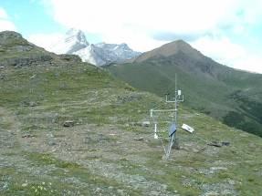
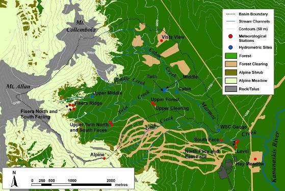
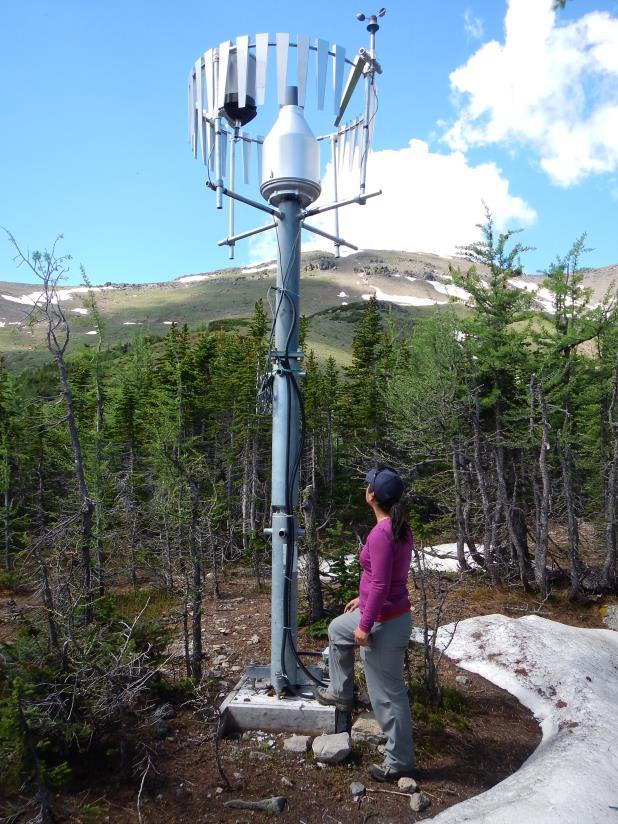
5 Marmot Creek Research Basin x x x x x x x
6 Marmot Creek Basin Hydrological Model

7 Hillslope Module
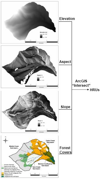
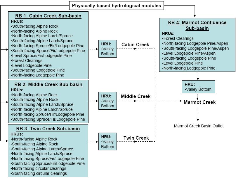
8 HRU Delineation and Model Structure
9 Forest Snow Dynamics Simulations Forest Clearing
10 North Face Alpine Snow Ridgetop Dynamics Simulations Upper South Face Lower South Face Snow redistribution from north face and ridgetop to south face and larch forest uncalibrated Larch Forest
11 Model Tests: Soil Moisture Level Forest Site Uncalibrated
12 No observed discharge during 2013 due to damaged gauges during flood. NSE MB NRMSD Cabin Middle Twin Marmot Daily Discharge (m^3/s) Uncalibrated Streamflow Test Daily Discharge (m^3/s) Marmot Creek Cabin Creek Simulation Observation Middle Creek Twin Creek

13 The Flood of June 2013

14 Marmot Creek Multi-elevation Precipitation Hay Meadow Upper Clearing Fisera Ridge
15 Hourly Rainfall Rate Marmot Creek 14 Rainfall Rate mm/hr /18/2013 6/19/2013 6/20/2013 6/21/2013 6/22/2013 6/23/2013 6/24/2013 6/25/2013 Hay Meadow (1436 m), Marmot Creek

16 Fisera Ridge Snowmelt
17 Clear-cut Soil Moisture Storage Upper Clearing, Marmot Creek
18 Flood Scenarios same time, different years
19 Flood Scenarios same time, different years

20 Scenario Flood Discharge over Last Eight Years Flood discharge: total discharge as result of the flood meteorology of June 2013 put as scenario in seven earlier years. Antecedent precipitation: total precipitation from beginning of hydrological year to onset of flood, i.e. 1 October to 16 June Antecedent air temperature: average temperature in June to onset of flood, i.e. 1 June to 16 June
 in order to forecast Smoky River")

21 Application: Operational Forecasting of Ungauged Snowmelt Runoff Smoky River Basin is 46% ungauged Need to simulate spring streamflow from the ungauged basin area (23,769 km 2 ) in order to forecast Smoky River contribution to the Peace River Run model on a daily basis during flood forecast period update ungauged flows Use daily updates of meteorological model forecast data to run for the future Route ungauged with gauged flows for forecast
22 Smoky River Basin: 51,839 km2

23 Challenge: Reliable Meteorological Observations and Forecasts


24 Interpolate, Predict, Forecast GEM-WISKI-CRHM North America Ensemble Forecast System: 21 ensemble forecasts, 16 days in the future Options to adjust forecast and run scenarios M

25 Land Cover and Soil Parameters

26 Sub-basins for Modelling Modelled all ungauged and gauged basins without real time hydrometric stations Sub-basins grouped into types based on ecoregion Real time gauged basins are estimated from gauge measurements and routed outside of CRHM using SSARR
27 Module Structure within each HRU

28 HRU Classification of Smoky Basin HRU classification and interpretation of land cover, topography, drainage, soils to determine parameters was guided by sub-basin type which depended on ecoregion
 for 3 HRUs")
29 Parameterisation Parameters measured where possible DEM, satellite-derived vegetation and soils maps Site visits for river roughness, interception Many parameters were brought in from research basin observations Hydraulic conductivity Soil depth Albedo, aerodynamic roughness One parameter calibrated from streamflow (sub-surface HRU travel time) for 3 HRUs
")
30 Routing between HRUs Routing sequence depends on sub-basin type (ecoregion)
31 Routing between Sub-basins Muskingum Routing used for river routing between sub-basins
32 Basin-scale Ungauged Prediction (a) (b) Great uncertainties in estimating local inflows for comparison to model results
 Predicted")

33 (a) Basin-scale Prediction Evaluation (b) Predicted flows, Nash-Sutcliff Statistic: 0.41 (Little Smoky) and 0.87 (Smoky)

34 Predicted Spring Discharge Volume 15 March-31 May
35 Predicted Spring Peak Discharge
36 Conclusions Uncertainty in hydrological prediction is gradually being reduced after decades of research in Western Canada. Incorporating snow redistribution, snowmelt, infiltration to frozen soils and fill and spill runoff generation processes in models can provide the basis for predictability in the Prairie Provinces. Physically based predictive models can interface with advanced weather forecasting models and be incorporated in flood forecasting procedures.
37
Snowmelt runoff sensitivity analysis to drought on the Canadian prairies
 HYDROLOGICAL PROCESSES Hydrol. Process. 21, 2594 2609 (2007) Published online in Wiley InterScience (www.interscience.wiley.com).6796 Snowmelt runoff sensitivity analysis to drought on the Canadian prairies
Impacts of snowpack accumulation and summer weather on alpine glacier hydrology
 Impacts of snowpack accumulation and summer weather on alpine glacier hydrology Caroline Aubry-Wake, Dhiraj Pradhananga, John W. Pomeroy GEWEX 8 th Open Science Meeting, Canmore AB, May 3-11 2018 Canadian
Preliminary Runoff Outlook February 2018
 Preliminary Runoff Outlook February 2018 Prepared by: Flow Forecasting & Operations Planning Water Security Agency General Overview The Water Security Agency (WSA) is preparing for 2018 spring runoff including
Snowcover accumulation and soil temperature at sites in the western Canadian Arctic
 Snowcover accumulation and soil temperature at sites in the western Canadian Arctic Philip Marsh 1, C. Cuell 1, S. Endrizzi 1, M. Sturm 2, M. Russell 1, C. Onclin 1, and J. Pomeroy 3 1. National Hydrology
Drought Monitoring with Hydrological Modelling
 st Joint EARS/JRC International Drought Workshop, Ljubljana,.-5. September 009 Drought Monitoring with Hydrological Modelling Stefan Niemeyer IES - Institute for Environment and Sustainability Ispra -
Flood Forecasting Methodology in Alberta
 Flood Forecasting Methodology in Alberta Evan Friesenhan, M.Eng., P.Eng Alberta Environment and Sustainable Resource Development March 17, 2014 River Forecast Team Mandate To provide Albertans with information
Development of the Hydrologic Model
 Kick-off meeting on enhancing hydrological data management and exchange procedures Water and Climate Adaptation Plan (WATCAP) for Sava River Basin Development of the Hydrologic Model David Heywood Team
APPLICATION OF AN ARCTIC BLOWING SNOW MODEL
 APPLICATION OF AN ARCTIC BLOWING SNOW MODEL J.W. Pomero l, P. ~arsh' and D.M. Gray2 -Hydrology Research Institute Saskatoon, Saskatchewan, Canada S7N 3H5 '~ivision of Hydrology, University of Saskatchewan
Climatic Change Implications for Hydrologic Systems in the Sierra Nevada
 Climatic Change Implications for Hydrologic Systems in the Sierra Nevada Part Two: The HSPF Model: Basis For Watershed Yield Calculator Part two presents an an overview of why the hydrologic yield calculator
Water information system advances American River basin. Roger Bales, Martha Conklin, Steve Glaser, Bob Rice & collaborators UC: SNRI & CITRIS
 Water information system advances American River basin Roger Bales, Martha Conklin, Steve Glaser, Bob Rice & collaborators UC: SNRI & CITRIS Opportunities Unprecedented level of information from low-cost
The Use of Inductive and Deductive Reasoning to Model Snowmelt Runoff from Northern Mountain Catchments
 International Congress on Environmental Modelling and Software Brigham Young University BYU ScholarsArchive 3rd International Congress on Environmental Modelling and Software - Burlington, Vermont, USA
Analysis of real-time prairie drought monitoring and forecasting system. Lei Wen and Charles A. Lin
 Analysis of real-time prairie drought monitoring and forecasting system Lei Wen and Charles A. Lin Back ground information A real-time drought monitoring and seasonal prediction system has been developed
NIDIS Intermountain West Regional Drought Early Warning System February 7, 2017
 NIDIS Drought and Water Assessment NIDIS Intermountain West Regional Drought Early Warning System February 7, 2017 Precipitation The images above use daily precipitation statistics from NWS COOP, CoCoRaHS,
Liliana Pagliero June, 15 th 2011
 Liliana Pagliero liliana.pagliero@jrc.ec.europa.eu June, 15 th 2011 2/18 SWAT MODELLING AT PAN EUROPEAN SCALE: THE DANUBE BASIN PILOT STUDY Introduction The Danube Model Available databases Model set up
12 SWAT USER S MANUAL, VERSION 98.1
 12 SWAT USER S MANUAL, VERSION 98.1 CANOPY STORAGE. Canopy storage is the water intercepted by vegetative surfaces (the canopy) where it is held and made available for evaporation. When using the curve
SNOW AND GLACIER HYDROLOGY
 SNOW AND GLACIER HYDROLOGY by PRATAP SINGH National Institute of Hydrology, Roorkee, India and VIJAY P. SINGH Department of Civil and Environmental Engineering, Louisiana State University, Baton Rouge,
Hydrologic Forecast Centre Manitoba Infrastructure, Winnipeg, Manitoba. FEBRUARY OUTLOOK REPORT FOR MANITOBA February 23, 2018
 Page 1 of 17 Hydrologic Forecast Centre Manitoba Infrastructure, Winnipeg, Manitoba FEBRUARY OUTLOOK REPORT FOR MANITOBA February 23, 2018 Overview The February Outlook Report prepared by the Hydrologic
Lecture 8: Snow Hydrology
 GEOG415 Lecture 8: Snow Hydrology 8-1 Snow as water resource Snowfall on the mountain ranges is an important source of water in rivers. monthly pcp (mm) 100 50 0 Calgary L. Louise 1 2 3 4 5 6 7 8 9 10
Sanjeev Kumar Jha Assistant Professor Earth and Environmental Sciences Indian Institute of Science Education and Research Bhopal
 Sanjeev Kumar Jha Assistant Professor Earth and Environmental Sciences Indian Institute of Science Education and Research Bhopal Email: sanjeevj@iiserb.ac.in 1 Outline 1. Motivation FloodNet Project in
Appendix D. Model Setup, Calibration, and Validation
 . Model Setup, Calibration, and Validation Lower Grand River Watershed TMDL January 1 1. Model Selection and Setup The Loading Simulation Program in C++ (LSPC) was selected to address the modeling needs
Assessment of extreme flood characteristics based on a dynamic-stochastic model of runoff generation and the probable maximum discharge
 Risk in Water Resources Management (Proceedings of Symposium H3 held during IUGG211 in Melbourne, Australia, July 211) (IAHS Publ. 347, 211). 29 Assessment of extreme flood characteristics based on a dynamic-stochastic
Tropics & Sub-Tropics. How can predictive approaches be improved: Data Sparse Situations
 Tropics & Sub-Tropics How can predictive approaches be improved: Data Sparse Situations 1. Protocol for catchment function diagnostics and model setup. Use of a decision tree as a preliminary stage to
Oregon Water Conditions Report May 1, 2017
 Oregon Water Conditions Report May 1, 2017 Mountain snowpack in the higher elevations has continued to increase over the last two weeks. Statewide, most low and mid elevation snow has melted so the basin
P. Marsh and J. Pomeroy National Hydrology Research Institute 11 Innovation Blvd., Saskatoon, Sask. S7N 3H5
 WATER AND ENERGY FLUXES DURING THE SNOWMELT PERIOD AT AN ARCTIC TREELINE SITE P. Marsh and J. Pomeroy National Hydrology Research Institute 11 Innovation Blvd., Saskatoon, Sask. S7N 3H5 marshp@nhrisv.nhrc.skdoe.ca
TABLE OF CONTENTS. 3.1 Synoptic Patterns Precipitation and Topography Precipitation Regionalization... 11
 TABLE OF CONTENTS ABSTRACT... iii 1 INTRODUCTION... 1 2 DATA SOURCES AND METHODS... 2 2.1 Data Sources... 2 2.2 Frequency Analysis... 2 2.2.1 Precipitation... 2 2.2.2 Streamflow... 2 2.3 Calculation of
Hydrologic Modelling of the Upper Malaprabha Catchment using ArcView SWAT
 Hydrologic Modelling of the Upper Malaprabha Catchment using ArcView SWAT Technical briefs are short summaries of the models used in the project aimed at nontechnical readers. The aim of the PES India
Merced Irrigation District Hydrologic and Hydraulic Operations (MIDH2O) Model
 Model") Merced Irrigation District Hydrologic and Hydraulic Operations (MIDH2O) Model September 05, 2018 Marco Bell, Merced Irrigation District Bibek Joshi, Dewberry Objective Introduce HEC-RTS Benefits of MIDH2O
Merced Irrigation District Hydrologic and Hydraulic Operations (MIDH2O) Model September 05, 2018 Marco Bell, Merced Irrigation District Bibek Joshi, Dewberry Objective Introduce HEC-RTS Benefits of MIDH2O
Flood Forecasting Methodology in Alberta
 Flood Forecasting Methodology in Alberta Evan Friesenhan, M.Eng., P.Eng Alberta Environment and Sustainable Resource Development February 18, 2014 River Forecast Team Mandate To provide Albertans with
FLORA: FLood estimation and forecast in complex Orographic areas for Risk mitigation in the Alpine space
 Natural Risk Management in a changing climate: Experiences in Adaptation Strategies from some European Projekts Milano - December 14 th, 2011 FLORA: FLood estimation and forecast in complex Orographic
MODELING STUDIES WITH HEC-HMS AND RUNOFF SCENARIOS IN YUVACIK BASIN, TURKIYE
 MODELING STUDIES WITH HEC-HMS AND RUNOFF SCENARIOS IN YUVACIK BASIN, TURKIYE Yener, M.K. Şorman, A.Ü. Department of Civil Engineering, Middle East Technical University, 06531 Ankara/Türkiye Şorman, A.A.
NIDIS Intermountain West Drought Early Warning System December 11, 2018
 NIDIS Drought and Water Assessment NIDIS Intermountain West Drought Early Warning System December 11, 2018 Precipitation The images above use daily precipitation statistics from NWS COOP, CoCoRaHS, and
Central Asia Regional Flash Flood Guidance System 4-6 October Hydrologic Research Center A Nonprofit, Public-Benefit Corporation
 http://www.hrcwater.org Central Asia Regional Flash Flood Guidance System 4-6 October 2016 Hydrologic Research Center A Nonprofit, Public-Benefit Corporation FFGS Snow Components Snow Accumulation and
Influence of rainfall space-time variability over the Ouémé basin in Benin
 102 Remote Sensing and GIS for Hydrology and Water Resources (IAHS Publ. 368, 2015) (Proceedings RSHS14 and ICGRHWE14, Guangzhou, China, August 2014). Influence of rainfall space-time variability over
Lake Tahoe Watershed Model. Lessons Learned through the Model Development Process
 Lake Tahoe Watershed Model Lessons Learned through the Model Development Process Presentation Outline Discussion of Project Objectives Model Configuration/Special Considerations Data and Research Integration
Water Supply Conditions and Outlook June 4, 2018
 Water Supply Conditions and Outlook June 4, 2018 Flow Forecasting & Operations Planning Water Security Agency Overview Water supply conditions across Saskatchewan are generally good with most reservoir
A Near Real-time Flood Prediction using Hourly NEXRAD Rainfall for the State of Texas Bakkiyalakshmi Palanisamy
 A Near Real-time Flood Prediction using Hourly NEXRAD for the State of Texas Bakkiyalakshmi Palanisamy Introduction Radar derived precipitation data is becoming the driving force for hydrological modeling.
CLIMATE CHANGE AND REGIONAL HYDROLOGY ACROSS THE NORTHEAST US: Evidence of Changes, Model Projections, and Remote Sensing Approaches
 CLIMATE CHANGE AND REGIONAL HYDROLOGY ACROSS THE NORTHEAST US: Evidence of Changes, Model Projections, and Remote Sensing Approaches Michael A. Rawlins Dept of Geosciences University of Massachusetts OUTLINE
MODULE 8 LECTURE NOTES 2 REMOTE SENSING APPLICATIONS IN RAINFALL-RUNOFF MODELLING
 MODULE 8 LECTURE NOTES 2 REMOTE SENSING APPLICATIONS IN RAINFALL-RUNOFF MODELLING 1. Introduction The most common application of the remote sensing techniques in the rainfall-runoff studies is the estimation
Hydrologic Forecast Centre Manitoba Infrastructure, Winnipeg, Manitoba. MARCH OUTLOOK REPORT FOR MANITOBA March 23, 2018
 Page 1 of 21 Hydrologic Forecast Centre Manitoba Infrastructure, Winnipeg, Manitoba MARCH OUTLOOK REPORT FOR MANITOBA March 23, 2018 Overview The March Outlook Report prepared by the Hydrologic Forecast
Study 16.5 Probable Maximum Flood (PMF)
") Initial Study Report Meeting Study 16.5 Probable Maximum Flood (PMF) March 30, 2016 Prepared by 3/30/2016 1 Study 16.5 Status ISR documents (ISR Part D Overview): Status: Initial Study Report: Parts A,
Initial Study Report Meeting Study 16.5 Probable Maximum Flood (PMF) March 30, 2016 Prepared by 3/30/2016 1 Study 16.5 Status ISR documents (ISR Part D Overview): Status: Initial Study Report: Parts A,
Workshop: Build a Basic HEC-HMS Model from Scratch
 Workshop: Build a Basic HEC-HMS Model from Scratch This workshop is designed to help new users of HEC-HMS learn how to apply the software. Not all the capabilities in HEC-HMS are demonstrated in the workshop
Environment Canada Modelling Systems and the 2013 Alberta Floods
 Environment Canada Modelling Systems and the 2013 Alberta Floods Calgary, Alberta February 19, 2014 Bruce Davison (EC) Al Pietroniro (EC) Nick Kouwen (UW) Anthony Liu (EC) Muluneh Mekonnen (AB) Ron Goodison
MARMOT CREEK BASIN: MANAGING FORESTS FOR WATER
 MARMOT CREEK BASIN: MANAGING FORESTS FOR WATER CABIN AND TWIN CREEK EXPERIMENTS 1962-1987 MARMOT CREEK SUBBASINS Subbasin Drainage Treatment Area (ha) (completion date) Cabin Creek 212 (50%)* Commercial
Hydrometeorological data from Marmot Creek Research Basin, Canadian Rockies
 Earth Syst. Sci. Discuss., https://doi.org/.194/essd-18-117 Manuscript under review for journal Earth Syst. Sci. Hydrometeorological data from Marmot Creek Research Basin, Canadian Rockies Xing Fang 1,
Terrestrial Snow Cover: Properties, Trends, and Feedbacks. Chris Derksen Climate Research Division, ECCC
 Terrestrial Snow Cover: Properties, Trends, and Feedbacks Chris Derksen Climate Research Division, ECCC Outline Three Snow Lectures: 1. Why you should care about snow: Snow and the cryosphere Classes of
How to integrate wetland processes in river basin modeling? A West African case study
 How to integrate wetland processes in river basin modeling? A West African case study stefan.liersch@pik-potsdam.de fred.hattermann@pik-potsdam.de June 2011 Outline Why is an inundation module required?
Oregon Water Conditions Report April 17, 2017
 Oregon Water Conditions Report April 17, 2017 Mountain snowpack continues to maintain significant levels for mid-april. By late March, statewide snowpack had declined to 118 percent of normal after starting
Canadian Prairie Snow Cover Variability
 Canadian Prairie Snow Cover Variability Chris Derksen, Ross Brown, Murray MacKay, Anne Walker Climate Research Division Environment Canada Ongoing Activities: Snow Cover Variability and Links to Atmospheric
Snowcover interaction with climate, topography & vegetation in mountain catchments
 Snowcover interaction with climate, topography & vegetation in mountain catchments DANNY MARKS Northwest Watershed Research Center USDA-Agricultural Agricultural Research Service Boise, Idaho USA RCEW
Precipitation. Standardized Precipitation Index. NIDIS Intermountain West Regional Drought Early Warning System January 3, 2017
 1/3/2017 NIDIS Drought and Water Assessment NIDIS Intermountain West Regional Drought Early Warning System January 3, 2017 Precipitation The images above use daily precipitation statistics from NWS COOP,
NIDIS Intermountain West Drought Early Warning System February 12, 2019
 NIDIS Intermountain West Drought Early Warning System February 12, 2019 Precipitation The images above use daily precipitation statistics from NWS COOP, CoCoRaHS, and CoAgMet stations. From top to bottom,
Land-Surface-Hydrological Models for Environmental Prediction
 Land-Surface-Hydrological Models for Environmental Prediction Dr. Alain Pietroniro P.Eng. Director Water Survey of Canada Environment Canada Dr. John Pomeroy Centre for Hydrology University of Saskatchewan
2 Development of a Physically Based Hydrologic Model of the Upper Cosumnes Basin
 2 Development of a Physically Based Hydrologic Model of the Upper Cosumnes Basin 2.1 Introduction The physically based watershed hydrologic model, WEHY (watershed environmental hydrology) model (Kavvas
APPENDIX B Hydrologic Model Spring Event
 Jock River Flood Risk Mapping (within the City of Ottawa) Hydrology Report July 2004 PageB1 APPENDIX B Hydrologic Model Spring Event Snowmelt+Rainfall Calibration and Validation Results Design Events Explanation
Flood Forecasting Methodology in Alberta
 Flood Forecasting Methodology in Alberta Colleen Walford, P.Eng Alberta Environment and Sustainable Resource Development March 24, 2014 River Forecast Team Mandate To provide Albertans with information
Water Yield and Precipitation Inputs for ECA-AB Analysis Grand Prairie Forest Management Area Weyerhaeuser Canada Ltd.
 Water Yield and Precipitation Inputs for ECA-AB Analysis Grand Prairie Forest Management Area Weyerhaeuser Canada Ltd. Prepared by Watertight Solutions August 30, 2007 Introduction The objective of this
NIDIS Intermountain West Drought Early Warning System May 23, 2017
 NIDIS Drought and Water Assessment NIDIS Intermountain West Drought Early Warning System May 23, 2017 Precipitation The images above use daily precipitation statistics from NWS COOP, CoCoRaHS, and CoAgMet
NIDIS Intermountain West Drought Early Warning System April 16, 2019
 NIDIS Intermountain West Drought Early Warning System April 16, 2019 Precipitation The images above use daily precipitation statistics from NWS COOP, CoCoRaHS, and CoAgMet stations. From top to bottom,
Operational Perspectives on Hydrologic Model Data Assimilation
 Operational Perspectives on Hydrologic Model Data Assimilation Rob Hartman Hydrologist in Charge NOAA / National Weather Service California-Nevada River Forecast Center Sacramento, CA USA Outline Operational
Operational Hydrologic Ensemble Forecasting. Rob Hartman Hydrologist in Charge NWS / California-Nevada River Forecast Center
 Operational Hydrologic Ensemble Forecasting Rob Hartman Hydrologist in Charge NWS / California-Nevada River Forecast Center Mission of NWS Hydrologic Services Program Provide river and flood forecasts
NIDIS Intermountain West Drought Early Warning System November 14, 2017
 NIDIS Intermountain West Drought Early Warning System November 14, 2017 Precipitation The images above use daily precipitation statistics from NWS COOP, CoCoRaHS, and CoAgMet stations. From top to bottom,
Overview of Data for CREST Model
 Overview of Data for CREST Model Xianwu Xue April 2 nd 2012 CREST V2.0 CREST V2.0 Real-Time Mode Forcasting Mode Data Assimilation Precipitation PET DEM, FDR, FAC, Slope Observed Discharge a-priori parameter
2017 Fall Conditions Report
 2017 Fall Conditions Report Prepared by: Hydrologic Forecast Centre Date: November 15, 2017 Table of Contents TABLE OF FIGURES... ii EXECUTIVE SUMMARY... 1 BACKGROUND... 4 SUMMER AND FALL PRECIPITATION...
ESTIMATING SNOWMELT CONTRIBUTION FROM THE GANGOTRI GLACIER CATCHMENT INTO THE BHAGIRATHI RIVER, INDIA ABSTRACT INTRODUCTION
 ESTIMATING SNOWMELT CONTRIBUTION FROM THE GANGOTRI GLACIER CATCHMENT INTO THE BHAGIRATHI RIVER, INDIA Rodney M. Chai 1, Leigh A. Stearns 2, C. J. van der Veen 1 ABSTRACT The Bhagirathi River emerges from
2015 Fall Conditions Report
 2015 Fall Conditions Report Prepared by: Hydrologic Forecast Centre Date: December 21 st, 2015 Table of Contents Table of Figures... ii EXECUTIVE SUMMARY... 1 BACKGROUND... 2 SUMMER AND FALL PRECIPITATION...
Hydrologic Forecast Centre. Manitoba Infrastructure. Winnipeg, Manitoba FEBRUARY FLOOD OUTLOOK REPORT FOR MANITOBA.
 Page 1 of 20 Hydrologic Forecast Centre Manitoba Infrastructure Winnipeg, Manitoba FEBRUARY FLOOD OUTLOOK REPORT FOR MANITOBA February 28, 2019 Overview The February Outlook Report prepared by the Hydrologic
The Importance of Snowmelt Runoff Modeling for Sustainable Development and Disaster Prevention
 The Importance of Snowmelt Runoff Modeling for Sustainable Development and Disaster Prevention Muzafar Malikov Space Research Centre Academy of Sciences Republic of Uzbekistan Water H 2 O Gas - Water Vapor
Floodplain modeling. Ovidius University of Constanta (P4) Romania & Technological Educational Institute of Serres, Greece
 Romania & Technological Educational Institute of Serres, Greece") Floodplain modeling Ovidius University of Constanta (P4) Romania & Technological Educational Institute of Serres, Greece Scientific Staff: Dr Carmen Maftei, Professor, Civil Engineering Dept. Dr Konstantinos
Floodplain modeling Ovidius University of Constanta (P4) Romania & Technological Educational Institute of Serres, Greece Scientific Staff: Dr Carmen Maftei, Professor, Civil Engineering Dept. Dr Konstantinos
GLACIER AND SNOWMELT MODELLING USING SWAT: GANGA BASIN CASE STUDY. INRM Consultants Pvt. Ltd.
 GLACIER AND SNOWMELT MODELLING USING SWAT: GANGA BASIN CASE STUDY INRM Consultants Pvt. Ltd. Introduction Snowmelt Runoff contribution in the Himalayan Rivers Estimation of Average contribution of Snowmelt
NIDIS Intermountain West Drought Early Warning System October 17, 2017
 NIDIS Drought and Water Assessment NIDIS Intermountain West Drought Early Warning System October 17, 2017 Precipitation The images above use daily precipitation statistics from NWS COOP, CoCoRaHS, and
Current and Future Plans. R. Srinivasan
 Current and Future Plans R. Srinivasan Contents 1 The ArcSWAT Interface 2 VizSWAT: Output Visualization 3 User online support 4 MapWindows SWAT interface 5 ArcGIS SWAT/APEX interfaces 6 Radar Rainfall
Study 16.5 Probable Maximum Flood (PMF)
") Initial Study Report Meeting Study 16.5 Probable Maximum Flood (PMF) October 22, 2014 Prepared by 10/22/2014 1 Study 16.5 Objectives Develop a site-specific PMP to be used for the derivation of the PMF
Initial Study Report Meeting Study 16.5 Probable Maximum Flood (PMF) October 22, 2014 Prepared by 10/22/2014 1 Study 16.5 Objectives Develop a site-specific PMP to be used for the derivation of the PMF
NIDIS Intermountain West Drought Early Warning System February 6, 2018
 NIDIS Intermountain West Drought Early Warning System February 6, 2018 Precipitation The images above use daily precipitation statistics from NWS COOP, CoCoRaHS, and CoAgMet stations. From top to bottom,
Results of Intensity-Duration- Frequency Analysis for Precipitation and Runoff under Changing Climate
 Results of Intensity-Duration- Frequency Analysis for Precipitation and Runoff under Changing Climate Supporting Casco Bay Region Climate Change Adaptation RRAP Eugene Yan, Alissa Jared, Julia Pierce,
Water Supply Conditions and Outlook October 1, 2018
 Water Supply Conditions and Outlook October 1, 2018 Flow Forecasting & Operations Planning Water Security Agency Overview Water supply conditions across Saskatchewan remain near normal, with most reservoirs
Abebe Sine Gebregiorgis, PhD Postdoc researcher. University of Oklahoma School of Civil Engineering and Environmental Science
 Abebe Sine Gebregiorgis, PhD Postdoc researcher University of Oklahoma School of Civil Engineering and Environmental Science November, 2014 MAKING SATELLITE PRECIPITATION PRODUCTS WORK FOR HYDROLOGIC APPLICATION
The Community Noah LSM with Multi-physics Options
 The Community Noah LSM with Multi-physics Options Guo-Yue Niu Collaborators: ZL Yang, KE Mitchell, F Chen, MB Ek, M. Barlage, L. Longuevergne, A Kumar, K Manning, D Niyogi, E Rosero, M Tewari, and Y. Xia
The Documentation of Extreme Hydrometeorlogical Events: Two Case Studies in Utah, Water Year 2005
 The Documentation of Extreme Hydrometeorlogical Events: Two Case Studies in Utah, Water Year 2005 Tim Bardsley1*, Mark Losleben2, Randy Julander1 1. USDA, NRCS, Snow Survey Program, Salt Lake City, Utah.
2016 Fall Conditions Report
 2016 Fall Conditions Report Prepared by: Hydrologic Forecast Centre Date: December 13, 2016 Table of Contents TABLE OF FIGURES... ii EXECUTIVE SUMMARY... 1 BACKGROUND... 5 SUMMER AND FALL PRECIPITATION...
Error Propagation from Radar Rainfall Nowcasting Fields to a Fully-Distributed Flood Forecasting Model
 Error Propagation from Radar Rainfall Nowcasting Fields to a Fully-Distributed Flood Forecasting Model Enrique R. Vivoni 1, Dara Entekhabi 2 and Ross N. Hoffman 3 1. Department of Earth and Environmental
KINEROS2/AGWA. Fig. 1. Schematic view (Woolhiser et al., 1990).
.") KINEROS2/AGWA Introduction Kineros2 (KINematic runoff and EROSion) (K2) model was originated at the USDA-ARS in late 1960s and released until 1990 (Smith et al., 1995; Woolhiser et al., 1990). The spatial
KINEROS2/AGWA Introduction Kineros2 (KINematic runoff and EROSion) (K2) model was originated at the USDA-ARS in late 1960s and released until 1990 (Smith et al., 1995; Woolhiser et al., 1990). The spatial
Watershed simulation and forecasting system with a GIS-oriented user interface
 HydroGIS 96: Application of Geographic Information Systems in Hydrology and Water Resources Management (Proceedings of the Vienna Conference, April 1996). IAHS Publ. no. 235, 1996. 493 Watershed simulation
Snow Melt with the Land Climate Boundary Condition
 Snow Melt with the Land Climate Boundary Condition GEO-SLOPE International Ltd. www.geo-slope.com 1200, 700-6th Ave SW, Calgary, AB, Canada T2P 0T8 Main: +1 403 269 2002 Fax: +1 888 463 2239 Introduction
ECCC/CCMEP variable resolution modelling of the Hudson Bay watershed
 ECCC/CCMEP variable resolution modelling of the Hudson Bay watershed Vincent Fortin (and many collaborators) Division de la recherche en météorologie Environnement en Changement climatique Canada GEM-based
Daytime long-wave radiation approximation for physical hydrological modelling of snowmelt: a case study of southwestern Ontario
 Soil-Vegetation-Atmosphere Transfer Schemes and Large-Scale Hydrological Models (Proceedings of a symposium held during tile Sixth I AI IS Scientific Assembly at Maastricht, The Netherlands. July 2001).
Evaluating extreme flood characteristics of small mountainous basins of the Black Sea coastal area, Northern Caucasus
 Proc. IAHS, 7, 161 165, 215 proc-iahs.net/7/161/215/ doi:1.5194/piahs-7-161-215 Author(s) 215. CC Attribution. License. Evaluating extreme flood characteristics of small mountainous basins of the Black
Snow and glacier change modelling in the French Alps
 International Network for Alpine Research Catchment Hydrology Inaugural Workshop Barrier Lake Field Station, Kananaskis Country, Alberta, Canada 22-24 October 2015 Snow and glacier change modelling in
Which map shows the stream drainage pattern that most likely formed on the surface of this volcano? A) B)
 B)") 1. When snow cover on the land melts, the water will most likely become surface runoff if the land surface is A) frozen B) porous C) grass covered D) unconsolidated gravel Base your answers to questions
1. When snow cover on the land melts, the water will most likely become surface runoff if the land surface is A) frozen B) porous C) grass covered D) unconsolidated gravel Base your answers to questions
Modelling snow accumulation and snow melt in a continuous hydrological model for real-time flood forecasting
 IOP Conference Series: Earth and Environmental Science Modelling snow accumulation and snow melt in a continuous hydrological model for real-time flood forecasting To cite this article: Ph Stanzel et al
Parameterization using ArcView GIS in medium and large watershed modelling
 50 GIS and Remote Sensing in Hydrology, Water Resources and Environment (Proceedings of ICGRHWE held at the Three Gorges Dam, China, September 2003). IAHS Publ. 289, 2004 Parameterization using ArcView
Interaction of North American Land Data Assimilation System and National Soil Moisture Network: Soil Products and Beyond
 Interaction of North American Land Data Assimilation System and National Soil Moisture Network: Soil Products and Beyond Youlong Xia 1,2, Michael B. Ek 1, Yihua Wu 1,2, Christa Peters-Lidard 3, David M.
Quantitative Flood Forecasts using Short-term Radar Nowcasting
 Quantitative Flood Forecasts using Short-term Radar Nowcasting Enrique R. Vivoni *, Dara Entekhabi *, Rafael L. Bras *, Matthew P. Van Horne *, Valeri Y. Ivanov *, Chris Grassotti + and Ross Hoffman +
APPLICATIONS OF DOWNSCALING: HYDROLOGY AND WATER RESOURCES EXAMPLES
 APPLICATIONS OF DOWNSCALING: HYDROLOGY AND WATER RESOURCES EXAMPLES Dennis P. Lettenmaier Department of Civil and Environmental Engineering For presentation at Workshop on Regional Climate Research NCAR
NIDIS Intermountain West Drought Early Warning System March 26, 2019
 NIDIS Intermountain West Drought Early Warning System March 26, 2019 The images above use daily precipitation statistics from NWS COOP, CoCoRaHS, and CoAgMet stations. From top to bottom, and left to right:
2017 January Conditions Report Manitoba Hydrologic Forecasting and Coordination Branch Manitoba Infrastructure
 2017 January Conditions Report Manitoba Hydrologic Forecasting and Coordination Branch Manitoba Infrastructure 1/30/2017 Page 1 of 22 Hydrologic Forecast Centre Manitoba Infrastructure and Transportation
NIDIS Intermountain West Drought Early Warning System December 18, 2018
 NIDIS Intermountain West Drought Early Warning System December 18, 2018 Precipitation The images above use daily precipitation statistics from NWS COOP, CoCoRaHS, and CoAgMet stations. From top to bottom,
Runoff-rainfall modelling: Predicting areal precipitation from runoff observations
 HydroPredict 212 Session M: Methodology, modelling, prediction and uncertainty 24. 27. September 212, Runoff-rainfall modelling: Predicting areal precipitation from runoff observations Mathew Herrnegger
Uncertainty analysis of nonpoint source pollution modeling:
 2013 SWAT Conference Uncertainty analysis of nonpoint source pollution modeling: An important implication for Soil and Water Assessment Tool Professor Zhenyao Shen 2013-07-17 Toulouse Contents 1 2 3 4
Hands On Applications of the Latin American and Caribbean Flood and Drought Monitor (LACFDM)
") Hands On Applications of the Latin American and Caribbean Flood and Drought Monitor (LACFDM) Colby Fisher, Eric F Wood, Justin Sheffield, Nate Chaney Princeton University International Training: Application
Hands On Applications of the Latin American and Caribbean Flood and Drought Monitor (LACFDM) Colby Fisher, Eric F Wood, Justin Sheffield, Nate Chaney Princeton University International Training: Application
Forest Hydrology: Lect. 9. Contents. Runoff, soil water and infiltration
 Forest Hydrology: Lect. 9 Contents Runoff, soil water and infiltration Learning objectives:. - Hillslope runoff generation processes; - Dynamics of runoff generation processes; - Hortonian and Dunnian