The Importance of Snowmelt Runoff Modeling for Sustainable Development and Disaster Prevention
|
|
|
- Spencer Lloyd
- 6 years ago
- Views:
Transcription

1 The Importance of Snowmelt Runoff Modeling for Sustainable Development and Disaster Prevention Muzafar Malikov Space Research Centre Academy of Sciences Republic of Uzbekistan
2 Water H 2 O Gas - Water Vapor Liquid - Rivers and Oceans Solid Ice and Snow Very strange substance (38 anomalies) Water shrinks on melting Hot water freezes faster than cold (clustering)
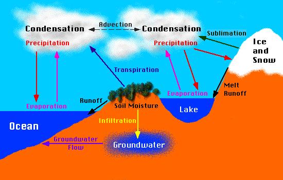
3 Hydrologic Cycle


4 Precipitation Rainfall Liquid water Produces immediate runoff Predictable runoff Snowfall Crystalline water Delayed runoff Difficult to predict


5 Why snowmelt runoff modeling? Drinking water supply


6 Why snowmelt runoff modeling? Flood control structures


7 Why snowmelt runoff modeling? Irrigation


8 Why snowmelt runoff modeling? Hydropower generation

9 Why snowmelt runoff modeling? Reservoir management
10 Types of models Physical models Based on strict physical laws Mass and energy balance Accuracy is high Conceptual Index models Empirical relationship to approximate mass balance Requires less parameters
11 Physical Models SNTHERM - US army corps CRREL LSM (land surface model) VIC (variable infiltration capacity) - U Washington WATCLASS (Watflood/class) - Env. Can SHE (Systeme Hydrologique Europeen) physically based, distributed, continuous Streamflow and sediment simulation, Abbott et al.
12 Conceptual Index Models SRM (Snowmelt Runoff Model) - USDA PRMS (precipitation runoff modeling system) - USGS SLURP (simple lumped reservoir) - Env. Can. UBC Watershed Model TOPMODEL (hydrologic simulation model) -Beven
13 Snowmelt Runoff Model Developed by Martinec Estimation of daily stream flow in Mountain basins Degree-day model (temperature) Applied in 25 countries for more than 80 basins Simple and Efficient
14 Remote Sensing Data SRM methodology Snow Cover Mapping Region of interest Cloud extrapolation Elevation zones DEM Meteorological data Daily temperature Daily precipitation Snow cover depletion Daily snow coverage Parameters Critical temperature Recession coefficient Snowmelt Runoff Model Snowmelt Runoff Simulation Forecast
15 SRM parameters Temperature (meteorological data) Precipitation (meteorological data) Daily Discharge Snow covered area (Remote Sensing data) DEM (topo map)
16 Q Heart of the model n+ 1 = [ Csn an( Tn + T n) Sn + Crn Pn ] (1 kn+ 1) + Qn kn+ 1 Q = average daily discharge [m 3 s -1 ] c = runoff coefficient: losses as a ratio (runoff/precipitation), with c Sn referring to snowmelt and c Rn to rain a = degree-day factor [cm oc -1 d -1 ] indicating the snowmelt depth resulting from 1 degree-day T = number of degree-days [ o C d] T = the adjustment by temperature lapse rate [ o C d] S = ratio of the snow covered area to the total area P = precipitation contributing to runoff [cm]. Threshold temperature, T CRIT, determines whether this contribution is rainfall or snowfall A = area of the basin or zone [km 2 ] k = recession coefficient indicating the decline of discharge in a period without snowmelt or rainfall n-number of days A
17 Parameters runoff Runoff coefficient, c = precipitation Degree day factor, a Amount of heat for a 24 hrs with a 1 ºC departure from a reference temperature. Converts number of degree-days into snowmelt depth Temperature lapse rate, γ Temperature change with the height Critical temperature, T crit Determines whether precipitation is snow or rain Rainfall contributing area, RCA Recession coefficient, k Decline of runoff in a period without precipitation Time Lag, L Time elapsed between the center of mass of the effective rainfall/snowmelt and the peak of direct runoff
18 Study Area Case Study Located at Kullu District Himachal Pradesh, India Geographical location: N, and E. Total area of the basin is 1790 km 2. Elevation difference from 800 m. to 6600 m. asl (Tichu Glacier). Temperature: min T=1 C, max T=30 C (Bhuntar 1000 m asl) Annual rainfall approximately 1000 mm (Bhuntar 1000 m asl)
19

20 Methodology RS data Snow Cover Mapping DEM Elevation zones Meteorological data Overlay Snowmelt simulation
21 Thematic Layers Elevation zones Snow cover maps Temperature distribution Rainfall distribution

22 Elevation Zones Map [m]

23 Calibration of Cr, Cs=0.5

24 Calibration of Cs, Cr-fixed
25 Variation of Snowmelt and Rainfall Runoff coefficients
26 Martinec-Rango SRM (calibration )
27 Actual discharge vs simulated ( )
28 Martinec-Rango SRM (validation )
29 Actual discharge vs simulated ( )
30 Results Martinec-Rango overestimates discharge during snowmelt season (10%) and underestimates in winter time (38%) It is possible to make short time forecasts (3-4 days), and approximate forecasts (1-2 month)
31 Limitations of Present Study 1. Snowmelt Runoff Model was developed for small European basins, but watersheds are highly varying all over the world. 2. Gauging stations are very less (Bhuntar) 3. Lapse rate is a good approximation of temperature variation vs elevation 4. Often discharge data is not available. 5. Very less snow gauging stations are available 6. Interpolation of Snow Cover Area Future Scope of Work 1. Reasonable temporal resolution of SRM inputs would significantly increase the accuracy of the model and allow SRM working in forecasting mode. 2. Weather simulation - long-term forecasts 3. Cost factor
32 System of Notification in Emergency Situations

33 Scenario of Central Asia SPOT 4 September 2001 Melt water is the major source of water Hydropower, Irrigation
34 What is being done? Data collection for similar project in Uzbekistan Practical application Higher temporary resolution of satellite imagery Availability of discharge data Close cooperation with interested ministries Ministry of Water and Agriculture Around sq km are under agriculture Ministry of Nature Protection Ministry of Emergency Situations More than 20 large water bodies Meteorological service


35
RELATIVE IMPORTANCE OF GLACIER CONTRIBUTIONS TO STREAMFLOW IN A CHANGING CLIMATE
 Proceedings of the Second IASTED International Conference WATER RESOURCE MANAGEMENT August 20-22, 2007, Honolulu, Hawaii, USA ISGN Hardcopy: 978-0-88986-679-9 CD: 978-0-88-986-680-5 RELATIVE IMPORTANCE
Snowmelt runoff forecasts in Colorado with remote sensing
 Hydrology in Mountainous Regions. I - Hydrologjcal Measurements; the Water Cycle (Proceedings of two Lausanne Symposia, August 1990). IAHS Publ. no. 193, 1990. Snowmelt runoff forecasts in Colorado with
SNOW AND GLACIER HYDROLOGY
 SNOW AND GLACIER HYDROLOGY by PRATAP SINGH National Institute of Hydrology, Roorkee, India and VIJAY P. SINGH Department of Civil and Environmental Engineering, Louisiana State University, Baton Rouge,
ESTIMATING SNOWMELT CONTRIBUTION FROM THE GANGOTRI GLACIER CATCHMENT INTO THE BHAGIRATHI RIVER, INDIA ABSTRACT INTRODUCTION
 ESTIMATING SNOWMELT CONTRIBUTION FROM THE GANGOTRI GLACIER CATCHMENT INTO THE BHAGIRATHI RIVER, INDIA Rodney M. Chai 1, Leigh A. Stearns 2, C. J. van der Veen 1 ABSTRACT The Bhagirathi River emerges from
Hydro-meteorological Analysis of Langtang Khola Catchment, Nepal
 Hydro-meteorological Analysis of Langtang Khola Catchment, Nepal Tirtha R. Adhikari 1, Lochan P. Devkota 1, Suresh.C Pradhan 2, Pradeep K. Mool 3 1 Central Department of Hydrology and Meteorology Tribhuvan
SNOWMELT RUNOFF ESTIMATION OF A HIMALIYAN WATERSHED THROUGH REMOTE SENSING, GIS AND SIMULATION MODELING
 SNOWMELT RUNOFF ESTIMATION OF A HIMALIYAN WATERSHED THROUGH REMOTE SENSING, GIS AND SIMULATION MODELING A. Alam g, *, A. H. Sheikh g, S. A. Bhat g, A. M.Shah g g Department of Geology & Geophysics University
Modelling runoff from large glacierized basins in the Karakoram Himalaya using remote sensing of the transient snowline
 Remote Sensing and Hydrology 2000 (Proceedings of a symposium held at Santa Fe, New Mexico, USA, April 2000). IAHS Publ. no. 267, 2001. 99 Modelling runoff from large glacierized basins in the Karakoram
EFFICIENCY OF THE INTEGRATED RESERVOIR OPERATION FOR FLOOD CONTROL IN THE UPPER TONE RIVER OF JAPAN CONSIDERING SPATIAL DISTRIBUTION OF RAINFALL
 EFFICIENCY OF THE INTEGRATED RESERVOIR OPERATION FOR FLOOD CONTROL IN THE UPPER TONE RIVER OF JAPAN CONSIDERING SPATIAL DISTRIBUTION OF RAINFALL Dawen YANG, Eik Chay LOW and Toshio KOIKE Department of
Measures Also Significant Factors of Flood Disaster Reduction
 Non-Structual Measures Also Significant Factors of Flood Disaster Reduction Babiaková Gabriela, Leškov ková Danica Slovak Hydrometeorological Institute, Bratislava Hydrological Forecasts and Warning Department
Modelling snow accumulation and snow melt in a continuous hydrological model for real-time flood forecasting
 IOP Conference Series: Earth and Environmental Science Modelling snow accumulation and snow melt in a continuous hydrological model for real-time flood forecasting To cite this article: Ph Stanzel et al
Using MODIS imagery to validate the spatial representation of snow cover extent obtained from SWAT in a data-scarce Chilean Andean watershed
 Using MODIS imagery to validate the spatial representation of snow cover extent obtained from SWAT in a data-scarce Chilean Andean watershed Alejandra Stehr 1, Oscar Link 2, Mauricio Aguayo 1 1 Centro
Central Asia Regional Flash Flood Guidance System 4-6 October Hydrologic Research Center A Nonprofit, Public-Benefit Corporation
 http://www.hrcwater.org Central Asia Regional Flash Flood Guidance System 4-6 October 2016 Hydrologic Research Center A Nonprofit, Public-Benefit Corporation FFGS Snow Components Snow Accumulation and
Abebe Sine Gebregiorgis, PhD Postdoc researcher. University of Oklahoma School of Civil Engineering and Environmental Science
 Abebe Sine Gebregiorgis, PhD Postdoc researcher University of Oklahoma School of Civil Engineering and Environmental Science November, 2014 MAKING SATELLITE PRECIPITATION PRODUCTS WORK FOR HYDROLOGIC APPLICATION
REMOTE SENSING OF SNOW COVER FOR OPERATIONAL FORECASTS *
 REMOTE SENSING OF SNOW COVER FOR OPERATIONAL FORECASTS * K. Seidel, J. Martinec, C. Steinmeier and W. Bruesch Remote Sensing Group Institute for Communication Technology Swiss Federal Institute of Technology
Operational snowmelt runoff forecasting in the Spanish Pyrenees using the snowmelt runoff model
 HYDROLOGICAL PROCESSES Hydrol. Process. 16, 1583 1591 (22) Published online in Wiley InterScience (www.interscience.wiley.com). DOI: 1.12/hyp.122 Operational snowmelt runoff forecasting in the Spanish
Climate change in Central Asia:Tienshan trends and future
 Climate change in Central Asia:Tienshan trends and future Ysmail Dairov, Regional Mountain Centre of Central Asia 23 October 2012, Eger, Hungary 1 The Regional Mountain Centre of Central Asia was established
Hands On Applications of the Latin American and Caribbean Flood and Drought Monitor (LACFDM)
") Hands On Applications of the Latin American and Caribbean Flood and Drought Monitor (LACFDM) Colby Fisher, Eric F Wood, Justin Sheffield, Nate Chaney Princeton University International Training: Application
Hands On Applications of the Latin American and Caribbean Flood and Drought Monitor (LACFDM) Colby Fisher, Eric F Wood, Justin Sheffield, Nate Chaney Princeton University International Training: Application
Drought Monitoring with Hydrological Modelling
 st Joint EARS/JRC International Drought Workshop, Ljubljana,.-5. September 009 Drought Monitoring with Hydrological Modelling Stefan Niemeyer IES - Institute for Environment and Sustainability Ispra -
Flood Forecasting Tools for Ungauged Streams in Alberta: Status and Lessons from the Flood of 2013
 Flood Forecasting Tools for Ungauged Streams in Alberta: Status and Lessons from the Flood of 2013 John Pomeroy, Xing Fang, Kevin Shook, Tom Brown Centre for Hydrology, University of Saskatchewan, Saskatoon
Modelling changes in the runoff regime in Slovakia using high resolution climate scenarios
 Modelling changes in the runoff regime in Slovakia using high resolution climate scenarios K. HLAVČOVÁ, R. VÝLETA, J. SZOLGAY, S. KOHNOVÁ, Z. MACUROVÁ & P. ŠÚREK Department of Land and Water Resources
CLIMATE CHANGE IMPACTS ON DISTRIBUTION AND MELT OF SNOW IN HIGH ALTITUDES AND LATITUDES
 CLIMATE CHANGE IMPACTS ON DISTRIBUTION AND MELT OF SNOW IN HIGH ALTITUDES AND LATITUDES JOSEF KRECEK Department of Hydrology Czech Technical University in Prague CRYOSPHERE Ice-caps Sea ice River and lake
DEVELOPMENT AND APPLICATION OF A HYDROCLIMATOLOGICAL STREAM TEMPERATURE MODEL WITHIN SWAT
 DEVELOPMENT AND APPLICATION OF A HYDROCLIMATOLOGICAL STREAM TEMPERATURE MODEL WITHIN SWAT Darren L. Ficklin 1, Yuzhou Luo 2, Iris T. Stewart 1, Edwin P. Maurer 3 1 Environmental Studies Institute, Santa
EVALUATION AND MONITORING OF SNOWCOVER WATER RESOURCES IN CARPATHIAN BASINS USING GEOGRAPHIC INFORMATION AND SATELLITE DATA
 EVALUATION AND MONITORING OF SNOWCOVER WATER RESOURCES IN CARPATHIAN BASINS USING GEOGRAPHIC INFORMATION AND SATELLITE DATA Gheorghe Stancalie, Simona Catana, Anisoara Iordache National Institute of Meteorology
Real-Time Meteorological Gridded Data: What s New With HEC-RAS
 Real-Time Meteorological Gridded Data: What s New With HEC-RAS Acquisition and Application of Gridded Meteorological Data in Support of the USACE s Real-Time Water Management Mission Fauwaz Hanbali, Tom
CARFFG System Development and Theoretical Background
 CARFFG Steering Committee Meeting 15 SEPTEMBER 2015 Astana, KAZAKHSTAN CARFFG System Development and Theoretical Background Theresa M. Modrick, PhD Hydrologic Research Center Key Technical Components -
Uncertainty in the SWAT Model Simulations due to Different Spatial Resolution of Gridded Precipitation Data
 Uncertainty in the SWAT Model Simulations due to Different Spatial Resolution of Gridded Precipitation Data Vamsi Krishna Vema 1, Jobin Thomas 2, Jayaprathiga Mahalingam 1, P. Athira 4, Cicily Kurian 1,
Lake Tahoe Watershed Model. Lessons Learned through the Model Development Process
 Lake Tahoe Watershed Model Lessons Learned through the Model Development Process Presentation Outline Discussion of Project Objectives Model Configuration/Special Considerations Data and Research Integration
Flash Flood Guidance System On-going Enhancements
 Flash Flood Guidance System On-going Enhancements Hydrologic Research Center, USA Technical Developer SAOFFG Steering Committee Meeting 1 10-12 July 2017 Jakarta, INDONESIA Theresa M. Modrick Hansen, PhD
Snowmelt Runoff Modelling under Projected Climate Change Patterns in the Gilgit River Basin of Northern Pakistan
 Pol. J. Environ. Stud. Vol. 26, No. 2 (2017), 525-542 DOI: 10.15244/pjoes/66719 Original Research Snowmelt Runoff Modelling under Projected Climate Change Patterns in the Gilgit River Basin of Northern
Heihe River Runoff Prediction
 Heihe River Runoff Prediction Principles & Application Dr. Tobias Siegfried, hydrosolutions Ltd., Zurich, Switzerland September 2017 hydrosolutions Overview Background Methods Catchment Characterization
Storm and Runoff Calculation Standard Review Snowmelt and Climate Change
 Storm and Runoff Calculation Standard Review Snowmelt and Climate Change Presented by Don Moss, M.Eng., P.Eng. and Jim Hartman, P.Eng. Greenland International Consulting Ltd. Map from Google Maps TOBM
Quenching the Valley s thirst: The connection between Sierra Nevada snowpack & regional water supply
 Quenching the Valley s thirst: The connection between Sierra Nevada snowpack & regional water supply Roger Bales, UC Merced Snow conditions Snow & climate change Research directions Sierra Nevada snow
Application of Satellite Data for Flood Forecasting and Early Warning in the Mekong River Basin in South-east Asia
 MEKONG RIVER COMMISSION Vientiane, Lao PDR Application of Satellite Data for Flood Forecasting and Early Warning in the Mekong River Basin in South-east Asia 4 th World Water Forum March 2006 Mexico City,
HyMet Company. Streamflow and Energy Generation Forecasting Model Columbia River Basin
 HyMet Company Streamflow and Energy Generation Forecasting Model Columbia River Basin HyMet Inc. Courthouse Square 19001 Vashon Hwy SW Suite 201 Vashon Island, WA 98070 Phone: 206-463-1610 Columbia River
Why modelling? Glacier mass balance modelling
 Why modelling? Glacier mass balance modelling GEO 4420 Glaciology 12.10.2006 Thomas V. Schuler t.v.schuler@geo.uio.no global mean temperature Background Glaciers have retreated world-wide during the last
The indicator can be used for awareness raising, evaluation of occurred droughts, forecasting future drought risks and management purposes.
 INDICATOR FACT SHEET SSPI: Standardized SnowPack Index Indicator definition The availability of water in rivers, lakes and ground is mainly related to precipitation. However, in the cold climate when precipitation
Hydrologic Overview & Quantities
 Hydrologic Overview & Quantities It is important to understand the big picture when attempting to forecast. This includes the interactive components and hydrologic quantities. Hydrologic Cycle The complexity
Hydrologic Forecast Centre Manitoba Infrastructure, Winnipeg, Manitoba. FEBRUARY OUTLOOK REPORT FOR MANITOBA February 23, 2018
 Page 1 of 17 Hydrologic Forecast Centre Manitoba Infrastructure, Winnipeg, Manitoba FEBRUARY OUTLOOK REPORT FOR MANITOBA February 23, 2018 Overview The February Outlook Report prepared by the Hydrologic
CHAPTER III DATA AND METHODOLOGY
 CHAPTER III DATA AND METHODOLOGY DATA AND METHODOLOGY 3.1 Study area Nuranang river basin (Fig. 3.1) located at Tawang district of Arunachal Pradesh, India with an area of 52 km 2 was selected for the
Operational Perspectives on Hydrologic Model Data Assimilation
 Operational Perspectives on Hydrologic Model Data Assimilation Rob Hartman Hydrologist in Charge NOAA / National Weather Service California-Nevada River Forecast Center Sacramento, CA USA Outline Operational
Inflow forecasting for lakes using Artificial Neural Networks
 Flood Recovery Innovation and Response III 143 Inflow forecasting for lakes using Artificial Neural Networks R. K. Suryawanshi 1, S. S. Gedam 1 & R. N. Sankhua 2 1 CSRE, IIT Bombay, Mumbai, India 2 National
Climate Change Impact on Drought Risk and Uncertainty in the Willamette River Basin
 Portland State University PDXScholar Geography Faculty Publications and Presentations Geography 5-24-2011 Climate Change Impact on Drought Risk and Uncertainty in the Willamette River Basin Heejun Chang
Enabling Climate Information Services for Europe
 Enabling Climate Information Services for Europe Report DELIVERABLE 6.5 Report on past and future stream flow estimates coupled to dam flow evaluation and hydropower production potential Activity: Activity
Study of Hydrometeorology in a Hard Rock Terrain, Kadirischist Belt Area, Anantapur District, Andhra Pradesh
 Open Journal of Geology, 2012, 2, 294-300 http://dx.doi.org/10.4236/ojg.2012.24028 Published Online October 2012 (http://www.scirp.org/journal/ojg) Study of Hydrometeorology in a Hard Rock Terrain, Kadirischist
Optimal Artificial Neural Network Modeling of Sedimentation yield and Runoff in high flow season of Indus River at Besham Qila for Terbela Dam
 Optimal Artificial Neural Network Modeling of Sedimentation yield and Runoff in high flow season of Indus River at Besham Qila for Terbela Dam Akif Rahim 1, Amina Akif 2 1 Ph.D Scholar in Center of integrated
The National Operational Hydrologic Remote Sensing Center Operational Snow Analysis
 The National Operational Hydrologic Remote Sensing Center Operational Snow Analysis World Meteorological Organization Global Cryosphere Watch Snow-Watch Workshop Session 3: Snow Analysis Products Andrew
Impacts of snowpack accumulation and summer weather on alpine glacier hydrology
 Impacts of snowpack accumulation and summer weather on alpine glacier hydrology Caroline Aubry-Wake, Dhiraj Pradhananga, John W. Pomeroy GEWEX 8 th Open Science Meeting, Canmore AB, May 3-11 2018 Canadian
Snow processes and their drivers in Sierra Nevada (Spain), and implications for modelling.
, and implications for modelling.") Snow processes and their drivers in Sierra Nevada (Spain), and implications for modelling. M.J. Polo, M.J. Pérez-Palazón, R. Pimentel, J. Herrero Granada,02 de November 2016 SECTIONS 1. 2. 3. 4. 5. Introduction
Snow processes and their drivers in Sierra Nevada (Spain), and implications for modelling. M.J. Polo, M.J. Pérez-Palazón, R. Pimentel, J. Herrero Granada,02 de November 2016 SECTIONS 1. 2. 3. 4. 5. Introduction
Operational Hydrologic Ensemble Forecasting. Rob Hartman Hydrologist in Charge NWS / California-Nevada River Forecast Center
 Operational Hydrologic Ensemble Forecasting Rob Hartman Hydrologist in Charge NWS / California-Nevada River Forecast Center Mission of NWS Hydrologic Services Program Provide river and flood forecasts
Statistical picture of climate changes in Central Asia: Temperature, precipitation, and river flow
 International Environmental Modelling and Software Society (iemss) 2010 International Congress on Environmental Modelling and Software Modelling for Environment s Sake, Fifth Biennial Meeting, Ottawa,
Development of the Hydrologic Model
 Kick-off meeting on enhancing hydrological data management and exchange procedures Water and Climate Adaptation Plan (WATCAP) for Sava River Basin Development of the Hydrologic Model David Heywood Team
The importance of the air temperature variable for the snowmelt runoff modelling using the SRM
 HYDROLOGICAL PROCESSES Hydrol. Process. 15, 3357 3370 (2001) DOI: 10.1002/hyp.1031 The importance of the air temperature variable for the snowmelt runoff modelling using the SRM C. Richard 1 * and D. J.
Inter-linkage case study in Pakistan
 7 th GEOSS Asia Pacific Symposium GEOSS AWCI Parallel Session: 26-28 May, 2014, Tokyo, Japan Inter-linkage case study in Pakistan Snow and glaciermelt runoff modeling in Upper Indus Basin of Pakistan Maheswor
MODULE 8 LECTURE NOTES 2 REMOTE SENSING APPLICATIONS IN RAINFALL-RUNOFF MODELLING
 MODULE 8 LECTURE NOTES 2 REMOTE SENSING APPLICATIONS IN RAINFALL-RUNOFF MODELLING 1. Introduction The most common application of the remote sensing techniques in the rainfall-runoff studies is the estimation
IMPLEMENTATION OF AN ICE JAM PREDICTOR WITH USER INTERFACE
 Ice in the Environment: Proceedings of the 16th IAHR International Symposium on Ice Dunedin, New Zealand, 2nd 6th December 2002 International Association of Hydraulic Engineering and Research IMPLEMENTATION
9. PROBABLE MAXIMUM PRECIPITATION AND PROBABLE MAXIMUM FLOOD
 9. PROBABLE MAXIMUM PRECIPITATION AND PROBABLE MAXIMUM FLOOD 9.1. Introduction Due to the size of Watana Dam and the economic importance of the Project to the Railbelt, the Probable Maximum Flood (PMF)
APPENDIX B Hydrologic Model Spring Event
 Jock River Flood Risk Mapping (within the City of Ottawa) Hydrology Report July 2004 PageB1 APPENDIX B Hydrologic Model Spring Event Snowmelt+Rainfall Calibration and Validation Results Design Events Explanation
investment decisions
 Climate modelling: A guide to investment decisions Vicky Pope Met Office Hadley Centre This is not an ADB material. The views expressed in this document are the views of the author/s and/or their organizations
ENGINEERING HYDROLOGY
 ENGINEERING HYDROLOGY Prof. Rajesh Bhagat Asst. Professor Civil Engineering Department Yeshwantrao Chavan College Of Engineering Nagpur B. E. (Civil Engg.) M. Tech. (Enviro. Engg.) GCOE, Amravati VNIT,
Hydrologic Forecast Centre Manitoba Infrastructure, Winnipeg, Manitoba. MARCH OUTLOOK REPORT FOR MANITOBA March 23, 2018
 Page 1 of 21 Hydrologic Forecast Centre Manitoba Infrastructure, Winnipeg, Manitoba MARCH OUTLOOK REPORT FOR MANITOBA March 23, 2018 Overview The March Outlook Report prepared by the Hydrologic Forecast
FLOODPLAIN MAPPING OF RIVER KRISHNANA USING HEC-RAS MODEL AT TWO STREACHES NAMELY KUDACHI AND UGAR VILLAGES OF BELAGAVI DISTRICT, KARNATAKA
 FLOODPLAIN MAPPING OF RIVER KRISHNANA USING HEC-RAS MODEL AT TWO STREACHES NAMELY KUDACHI AND UGAR VILLAGES OF BELAGAVI DISTRICT, KARNATAKA Sandhyarekha 1, A. V. Shivapur 2 1M.tech Student, Dept. of and
A HISTORICAL PERSPECTIVE ON THE SNOW STUDIES IN TURKEY. Prof.Dr. A. Ünal ŞORMAN 1,2
 A HISTORICAL PERSPECTIVE ON THE SNOW STUDIES IN TURKEY Prof.Dr. A. Ünal ŞORMAN 1,2 Aynur Şensoy 3, Arda Şorman 3, Gökçen Uysal 3, Cansaran Ertaş 3, Bulut Akkol 3, Cihan Çoşkun 3 1 N e a r E a s t U n i
MULTISENSOR AND MULTITEMPORAL SATELLITE DATA FOR RUNOFF FORECAST IN HIGH ALPINE ENVIRONMENT
 ABSTRACT: MULTISENSOR AND MULTITEMPORAL SATELLITE DATA FOR RUNOFF FORECAST IN HIGH ALPINE ENVIRONMENT A. N. Swamy*, P. A. Brivio and E. zilioli Remote Sensing Dept, Institute of Geophysics of the Lithosphere
NIDIS Intermountain West Drought Early Warning System October 17, 2017
 NIDIS Drought and Water Assessment NIDIS Intermountain West Drought Early Warning System October 17, 2017 Precipitation The images above use daily precipitation statistics from NWS COOP, CoCoRaHS, and
MODELING STUDIES WITH HEC-HMS AND RUNOFF SCENARIOS IN YUVACIK BASIN, TURKIYE
 MODELING STUDIES WITH HEC-HMS AND RUNOFF SCENARIOS IN YUVACIK BASIN, TURKIYE Yener, M.K. Şorman, A.Ü. Department of Civil Engineering, Middle East Technical University, 06531 Ankara/Türkiye Şorman, A.A.
Midwest and Great Plains Drought and Climate Summary 20 February 2014
 Midwest and Great Plains Drought and Climate Summary 20 February 2014 Wendy Ryan Assistant State Climatologist Colorado Climate Center Colorado State University wendy.ryan@colostate.edu 970-491-8506 General
MONITORING OF SEASONAL SNOW COVER IN YAMUNA BASIN OF UTTARAKAHND HIMALAYA USING REMOTE SENSING TECHNIQUES
 MONITORING OF SEASONAL SNOW COVER IN YAMUNA BASIN OF UTTARAKAHND HIMALAYA USING REMOTE SENSING TECHNIQUES Anju Panwar, Devendra Singh Uttarakhand Space Application Centre, Dehradun, India ABSTRACT Himalaya
Application of SWAT for the modelling of sediment yield at Pong reservoir, India
 Application of SWAT for the modelling of sediment yield at Pong reservoir, India A. R. Senthil kumar Tanmoyee Bhattacharya Suhas D Khobragade Manohar Arora National Institute of Hydrology Roorkee-247667,
GLACIER AND SNOWMELT MODELLING USING SWAT: GANGA BASIN CASE STUDY. INRM Consultants Pvt. Ltd.
 GLACIER AND SNOWMELT MODELLING USING SWAT: GANGA BASIN CASE STUDY INRM Consultants Pvt. Ltd. Introduction Snowmelt Runoff contribution in the Himalayan Rivers Estimation of Average contribution of Snowmelt
IMPACT OF CLIMATE CHANGE OVER THE ARABIAN PENINSULA
 IMPACT OF CLIMATE CHANGE OVER THE ARABIAN PENINSULA By: Talal Alharbi June, 29 2017 1 Motivation: In arid and semi-arid regions of the world the demand for fresh water resources is increasing due to: increasing
MODELLING DAILY RUNOFF FROM SNOW AND GLACIER MELT USING REMOTE SENSING DATA
 MODELLING DAILY RUNOFF FROM SNOW AND GLACIER MELT USING REMOTE SENSING DATA J. Schaper and K. Seidel Computer Vision Group, Communication Technology Laboratory ETH Zurich, Switzerland Tel: +41 1 632 42
NIDIS Intermountain West Regional Drought Early Warning System February 7, 2017
 NIDIS Drought and Water Assessment NIDIS Intermountain West Regional Drought Early Warning System February 7, 2017 Precipitation The images above use daily precipitation statistics from NWS COOP, CoCoRaHS,
Snowmelt Runoff Estimation of Jhelum Basin with SRM Model
 Snowmelt Runoff Estimation of Jhelum Basin with SRM Model Geeta Devi Assistant professor Chandigarh University Gharuan Mohali, Punjab, India Abstract Precipitation is a form of crystalline water ice is
Speakers: NWS Buffalo Dan Kelly and Sarah Jamison, NERFC Jeane Wallace. NWS Flood Services for the Black River Basin
 Speakers: NWS Buffalo Dan Kelly and Sarah Jamison, NERFC Jeane Wallace NWS Flood Services for the Black River Basin National Weather Service Who We Are The National Oceanic and Atmospheric Administration
Watershed simulation and forecasting system with a GIS-oriented user interface
 HydroGIS 96: Application of Geographic Information Systems in Hydrology and Water Resources Management (Proceedings of the Vienna Conference, April 1996). IAHS Publ. no. 235, 1996. 493 Watershed simulation
Hydrologic Modelling of the Upper Malaprabha Catchment using ArcView SWAT
 Hydrologic Modelling of the Upper Malaprabha Catchment using ArcView SWAT Technical briefs are short summaries of the models used in the project aimed at nontechnical readers. The aim of the PES India
Near Real-Time Runoff Estimation Using Spatially Distributed Radar Rainfall Data. Jennifer Hadley 22 April 2003
 Near Real-Time Runoff Estimation Using Spatially Distributed Radar Rainfall Data Jennifer Hadley 22 April 2003 Introduction Water availability has become a major issue in Texas in the last several years,
Supplementary Materials for
 advances.sciencemag.org/cgi/content/full/3/12/e1701169/dc1 Supplementary Materials for Abrupt shift in the observed runoff from the southwestern Greenland ice sheet Andreas P. Ahlstrøm, Dorthe Petersen,
Simulation of sedimentation rates using the SWAT model A case study of the Tarbela Dam, Upper Indus Basin
 Simulation of sedimentation rates using the SWAT model A case study of the Tarbela Dam, Upper Indus Basin Ahammad, H. I 1., Crosato A 2,3., Maskey, S 2., Masih, I 2,*, McClain, M 2. 1 Punjab Irrigation
An Overview of Operations at the West Gulf River Forecast Center Gregory Waller Service Coordination Hydrologist NWS - West Gulf River Forecast Center
 National Weather Service West Gulf River Forecast Center An Overview of Operations at the West Gulf River Forecast Center Gregory Waller Service Coordination Hydrologist NWS - West Gulf River Forecast
A Comparison of Rainfall Estimation Techniques
 A Comparison of Rainfall Estimation Techniques Barry F. W. Croke 1,2, Juliet K. Gilmour 2 and Lachlan T. H. Newham 2 SUMMARY: This study compares two techniques that have been developed for rainfall and
ANALYSIS OF FLOODS AND DROUGHTS IN THE BAGO RIVER BASIN, MYANMAR, UNDER CLIMATE CHANGE
 ANALYSIS OF FLOODS AND DROUGHTS IN THE BAGO RIVER BASIN, MYANMAR, UNDER CLIMATE CHANGE Myo Myat Thu* MEE15631 ABSTRACT 1 Supervisor: Dr. Maskym Gusyev** Dr. Akira Hasegawa** This study investigates floods
Climate Change and Water Supplies in the West. Michael Dettinger, USGS
 Climate Change and Water Supplies in the West Michael Dettinger, USGS During the past 30 years--and in the near-term future--natural climate variability has been augmented by warming trends associated
Precipitation. Standardized Precipitation Index. NIDIS Intermountain West Regional Drought Early Warning System January 3, 2017
 1/3/2017 NIDIS Drought and Water Assessment NIDIS Intermountain West Regional Drought Early Warning System January 3, 2017 Precipitation The images above use daily precipitation statistics from NWS COOP,
CLIMATE CHANGE AND REGIONAL HYDROLOGY ACROSS THE NORTHEAST US: Evidence of Changes, Model Projections, and Remote Sensing Approaches
 CLIMATE CHANGE AND REGIONAL HYDROLOGY ACROSS THE NORTHEAST US: Evidence of Changes, Model Projections, and Remote Sensing Approaches Michael A. Rawlins Dept of Geosciences University of Massachusetts OUTLINE
Assessment of Snowmelt Runoff in the Eastern Himalayan Region under Climate Change Scenarios
 A. J. Ind. Bandyopadhyay, Geophys. Union A. Bhadra, ( July 2015 N. Chiphang, ) K.T. Senzeba v.19, no.3, pp:312-321 Assessment of Snowmelt Runoff in the Eastern Himalayan Region under Climate Change Scenarios
Climate also has a large influence on how local ecosystems have evolved and how we interact with them.
 The Mississippi River in a Changing Climate By Paul Lehman, P.Eng., General Manager Mississippi Valley Conservation (This article originally appeared in the Mississippi Lakes Association s 212 Mississippi
4 th Joint Project Team Meeting for Sentinel Asia 2011
 A Revisit on the Structural Flood Mitigation Measure with the Application of Remote Sensing and GIS in Gin River Basin, Sri Lanka 4 th Joint Project Team Meeting for Sentinel Asia 2011 Geoinformatics Center
Delaware River Flood Advisory Committee
 Delaware River Flood Advisory Committee A Partnership to Support Flood Mitigation Alan Tamm Pennsylvania Emergency Management Agency Bureau of Recovery and Mitigation atamm@state.pa.us Peter Gabrielsen
Seasonal Rainfall Trend Analysis
 RESEARCH ARTICLE OPEN ACCESS Seasonal Rainfall Trend Analysis Devdatta V. Pandit Research Scholar, Dept. of SWCE, M.P.K.V, Rahuri- 413722, Ahmednagar. (M., India ABSTRACT This study aims to detect the
CHAPTER VII FULLY DISTRIBUTED RAINFALL-RUNOFF MODEL USING GIS
 80 CHAPTER VII FULLY DISTRIBUTED RAINFALL-RUNOFF MODEL USING GIS 7.1GENERAL This chapter is discussed in six parts. Introduction to Runoff estimation using fully Distributed model is discussed in first
January 25, Summary
 January 25, 2013 Summary Precipitation since the December 17, 2012, Drought Update has been slightly below average in parts of central and northern Illinois and above average in southern Illinois. Soil
Chapter-1 Introduction
 Modeling of rainfall variability and drought assessment in Sabarmati basin, Gujarat, India Chapter-1 Introduction 1.1 General Many researchers had studied variability of rainfall at spatial as well as
Hydrological modeling and flood simulation of the Fuji River basin in Japan
 Hydrological modeling and flood simulation of the Fuji River basin in Japan H. A. P. Hapuarachchi *, A. S. Kiem, K. Takeuchi, H. Ishidaira, J. Magome and A. Tianqi T 400-8511, Takeuchi-Ishidaira Lab, Department
Presentation Overview. Southwestern Climate: Past, present and future. Global Energy Balance. What is climate?
 Southwestern Climate: Past, present and future Mike Crimmins Climate Science Extension Specialist Dept. of Soil, Water, & Env. Science & Arizona Cooperative Extension The University of Arizona Presentation
Water information system advances American River basin. Roger Bales, Martha Conklin, Steve Glaser, Bob Rice & collaborators UC: SNRI & CITRIS
 Water information system advances American River basin Roger Bales, Martha Conklin, Steve Glaser, Bob Rice & collaborators UC: SNRI & CITRIS Opportunities Unprecedented level of information from low-cost
2015 Fall Conditions Report
 2015 Fall Conditions Report Prepared by: Hydrologic Forecast Centre Date: December 21 st, 2015 Table of Contents Table of Figures... ii EXECUTIVE SUMMARY... 1 BACKGROUND... 2 SUMMER AND FALL PRECIPITATION...
Folsom Dam Water Control Manual Update
 Folsom Dam Water Control Manual Update Public Workshop April 3, 2014 Location: Sterling Hotel Ballroom 1300 H Street, Sacramento US Army Corps of Engineers BUILDING STRONG WELCOME & INTRODUCTIONS 2 BUILDING
Missouri River Flood Task Force River Management Working Group Improving Accuracy of Runoff Forecasts
 Missouri River Flood Task Force River Management Working Group Improving Accuracy of Runoff Forecasts Kevin Grode, P.E. Reservoir Regulation Team Lead Missouri River Basin Water Management Northwestern
Watershed Modeling with GIS and Remote Sensing
 Britta Anderson 12/15/15 Watershed Modeling with GIS and Remote Sensing How do GIS & RS Support Watershed Modeling? A watershed model is a simplified, mathematical representation of the hydrologic cycle