Domain Land Use/Cover Data Model Enabling Multiple Use for Turkey
|
|
|
- Derek Ward
- 6 years ago
- Views:
Transcription
1 Domain Land Use/Cover Data Model Enabling Multiple Use for Turkey Key words: Spatial Data Management, LULC, Land Use/Cover SUMMARY Land use/ land cover (LULC) information, one aspect of GI, has huge important in natural resource management, environmental management, risk management, and the applications like this. By this way, land cover data presenting the physical coverage of the earth surface and land use data presenting its socio-economic purpose should be produced and used with common approaches. In Turkey, LULC data has been used in different standards and there is no a common definition and classification system accepted in public institutions. In this study, the public institutions working with LULC data were determined and data needs for their environmental projects and GIS applications were analyzed. Depending on this Field Work, LULC classification system was defined from local to national level hierarchically, based on CORINE (Coordination of information on the environment) classification system. That was done as to scale groups and data usage levels including 5 levels. Feature catalogues and application schemas were prepared to use LULC data effectively. To test this model, LULC feature class with high resolution (Level 5) was produced by using QuickBird satellite image and cases of Trabzon Municipality. To use this data on various domains, that was generalized to other use levels with low resolution (Level 4 to 1) by generalization techniques. As a case study, LULC data were used on various thematic applications at different levels, such as planning, urban atlas, and like this. By this way, Turkey LULC data model was designed and tested to promote the multiple use of LULC data to support environment, public health, and the sustainable development of urban areas, and like this. 1/10
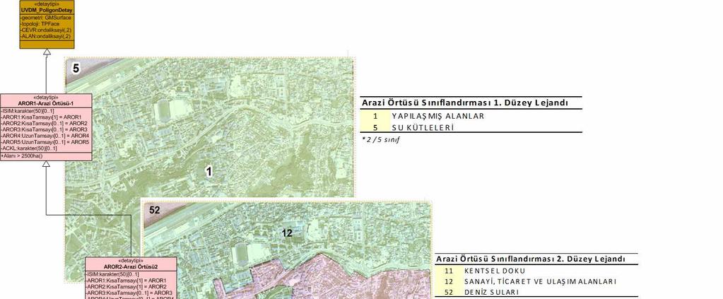
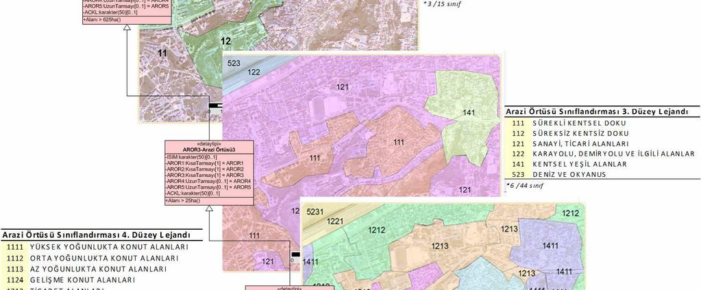
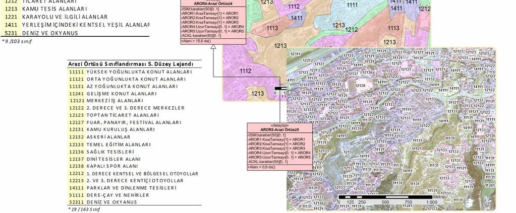
2 Domain Land Use/Cover Data Model Enabling Multiple Use for Turkey Arif Cagdas AYDINOGLU 1 and Oğuz GUNGOR 2, Turkey 1. INTRODUCTION Determining land cover/use types with their spatial and temporal distribution is necessary for a wide range of studies. Knowledge of the present distribution and area of such agricultural, recreational, and urban lands, as well as information on their changing proportions, is needed by legislators, planners, and state and local governmental officials to determine better land use policy, to project transportation and utility demand, to identify future development pressure points and areas, and to implement effective plans for regional development. In many cases, the terms land cover and land use are regarded as mutual, exchangeable expressions, although there are differences between them. Land cover refers to the physical material covering the surface of the Earth including vegetation, water, soil, and physical features those created by human activities such as buildings, asphalt, etc. On the other hand, land-use refers to the way how land is used by humans and their habitat [Ramachandra and Kumar 2004]. By this way, land use is characterized by the arrangement and activities people undertake in a certain land cover type to produce or change it [Gregoria and Jansen, 2000, Anderson, etc., 1976]. This can establish a direct link between land use and land cover and can be described with LULC acronym. Most land cover classification systems are also hierarchically structured because such a classification offers more consistency owing to its ability to accommodate different levels of information. These systems generally start with high classes and divide them into more detailed sub-classes to help us use land cover data efficiently [Car 1997; Glasgow 1995]. However, there is no a standard classification system that has been accepted internationally [Duhamel, 1995]. Many systems have been developed for a certain purpose, at a certain scale, and using a certain data type. As a result, countries define their own national land-cover classification systems. However, land-cover data coming from different countries should also be used in coordination. As an example, Coordination of information on the environment (CORINE) project was executed in 13 European countries in 1991 by European Commission (EC). The purpose of the CORINE programme was to combine and coordinate all the attempts which have been made over the years at international, community, national and regional levels to obtain more information on the environment and to monitor how it changes. Following the pilot project in Portugal, the methodology and the CORINE land-cover nomenclature, which consists of three levels, was defined. The first level, which includes five items, indicates the major categories of land cover on Earth. The second level, consisting of 15 items, is for use on scales of 1: and 1: and the third level, having 44 items, is to use in the projects on a scale of 1: [EEA, 1997, 2008].. Similar to CORINE project, HarmonISA project [Hall 2006] was also initiated in 2003 for the automatic integration of LULC data in the three regions of Friuli Venezia-Giulia (Italy), Slovenia and Carinthia (Austria). 2/10
3 In this study, The use of LULC data was examined in public institutions of Turkey. According to the field work, the needs and expectations of public institutions were determined to produce and use LULC data. LULC data was modeled and classified hierarchically as sub-classes of CORINE database. The model enables hierarchical classification of LULC based on scale of the map and data usage levels. This model aims at meeting user needs on all application levels of Turkey. To use spatial data on various domains, that was generalized to low resolution feature classes (Level 4 to 1) by generalization techniques as case study. 2. LAND USE/COVER DATA NEEDS OF PUBLIC INSTITUTIONS IN TURKEY Turkey has already achieved some success in standardization of land cover data at some degree. However, there are still different approaches while describing land cover types. When GIS projects implemented by Ministry of Forestry and Ministry of Agriculture are inspected, it can be seen easily that there is no standard in the description and definition of land covers; therefore, there is also no common hierarchic system used to determine classes and subclasses. As a result, projects executed by them have not reached to desired level as needed. Additionally, since these institutions have worked independently and without coordination, there are also many overlaps in the projects, which results in duplication of efforts to do the same thing. It also has been found that data collected for a specific purpose were of little or no value for a similar purpose. [LRCD, 2004]. According to Reconstruction and Development Act (No. 3194), land use in urban areas must be planned and implemented by considering given standard legends on the act [Offic.Gaz., 1985]. Ministry of Agriculture classifies agricultural land into four categories as arable land, land for specific products, orchard and groves, and marginal agricultural land (not suitable for agriculture) according to Soil Protection and Land Use Act (No. 5403). [Offic.Gaz., 2005].. Additionally, there is also no standard while describing land use information of land parcels. Directorates of Land Registry and Cadastre records the land use type of each land parcel during cadastre; however, this effort is far beyond setting standardization since defining the land use type of each land parcel is left to the initiative of the employees. According to ministrial reports [LRCD, 2006] and the Field Work executed to the public institutions of Turkey that produce and use spatial data, the public institutions using LULC data were determined and grouped hierarchically. Provincial System is the main administrative unit of Turkey. Main approach is that if a spatial database is modeled for a particular province, it should also be applicable from local to national level for all other provinces. 12 of Public Institutions, highlighted as yellow rectangles in Figure 1, have been analyzed to examine Land Cover/Use data needs in their environmental projects and GIS applications. Their administration levels, main functions as producer (P) or user (U), and responsibilities are listed in Table 1. Trabzon, one of the 81 provinces of Turkey, was chosen as a pilot province, so that proposed classification system will be a model for all other provinces. Land Cover/Use data needs were determined with Data /Function Matrix that was produced as a result of Fieldwork executed to public institutions of Trabzon on Table 1. User requirements are described in use case analysis. As a result of these analyses, land use classes for urban area, arable land, forest, wetlands, water bodies are determined and listed based on the map legends of various institutions. As a result, 163 land use classes were determined and categorized in local level. 3/10
4 Table 1. Public Institutions Use Level, Function, and Work Discipline about Land Cover/Use Data Public Institutions/ Organizations Provincial Public Administration (Municipalities/County/B elde Regional Directorate of Provincial Bank Provincial Dir. of Public works and settlement Use Level LCUD 3 P/U 3/4 P/U 2 P 3 U Dir. Of Cadastre 3/4 P Regional Dir. of State ports and airports Const Regional Dir. Of Transportation Regional Dir. Of Forestry and Management Regional Dir. Of State Hydraulic Works Regional Dir. of Mineral Research and Exploration Provincial Dir. of Agriculture 2 U 2 U 2/3 P 2 P 2 U 3 P/U Work Discipline Responsible from construction of infrastructure and control of illegal urbanization in areas out of reconstruction and development plans made by municipalities. Produces LULC data for environmental management plans and site selection analysis of public facilities. Responsible from all urbanization activities including construction and maintain of infrastructure, making and implementing urban plans, and generating land use data, etc. Provides financial support for the engineering projects conducted by local authorities. Supports mapping projects which also produce LULC data Uses LULC data to produce costal area management and disaster management plans. Determines land use attribute of land parcels when determining their area and ownership. Uses LULC data while making infrastructure and construction plans of airways and waterways and terminals such as airports and seaports. Uses LULC data while making infrastructure and construction plans of roads. Produces cadastre maps and lands use data and maps for forest. Produces forest management plans. Determines forest, park, recreational and conservation areas. Responsible from protection and control of flood and soil erosion. Uses LULC data while producing mining district maps and determining mineral locations Produces soil and land cover maps to determine the best locations for agriculture. Generates land use data of arable lands. P: Provider, U: User 3. UVDM:AR- Turkey National Spatial Data Exchange Model for Land Surface The name of LULC data model, produced in this study, is Turkey National Spatial Data Exchange Model for Land Surface with UVDM:AR acronym. The model enables hierarchical classification of land cover/use classes based on scale of the map and data usage levels. This classification system is based on CORINE Land Cover (CLC) classification, which is utilized in European countries. The CLC nomenclature is a physical and physiognomic land cover nomenclature comprising three levels. The nomenclature is strongly related to the process of image interpretation, scale, and the smallest spatial unit. The spatial unit corresponds both to an area of homogeneous land cover and to an aggregation of small 4/10
5 homogeneous areas that represent a land cover class such as water, forest, etc. The spatial unit represents a significant surface in relation to the work scale and can be distinguishable from other surrounding units. All spatial units are polygons. This structure guarantees the topology coherence because the overlapping of two polygons is impossible. As a spatial unit, the smallest area that can be represented as a land cover class in the map is 25 hectare. [EEA, 2000, 2008]. UVDM:AR includes LULC nomenclature comprising 5 levels as seen on Figure 2. The first, second, and third level classification of UVDM:AR are based on the CLC with coded attribute values hierarchically, as explained below; UVDM:AR Level-1 consists of 5 main classes described with integers between 1 and 5 to represent land covers at 1: or smaller scales. For example, Artificial surfaces is described by 1. UVDM:AR Level-2 contains 15 classes to be used at map scales between 1: and 1: These categories are described with two digit integers such that the digit to the left represents upper level (Level-1), whereas the digit to the right describes the land cover type at the second level. For example, 12 represent Industrial, Commercial, and Transport units, which is a sub-class of artificial surfaces represented with 1 at level-1. UVDM:AR Level-3 consists of 44 classes to be used at applications using maps at a scale of 1: and larger. In this level, the categories are described with three digit numbers as the children of categories at level-2. For example, Industrial or commercial units is represented with 121, which means that this land cover is sub-class of the unit represented with 12. In fact, these classes are not only categories of different land covers, but also categories of different land use. Therefore, a deductive analysis is required to determine level- 3 and sub-level classes. UVDM:AR classes at level-4 and level-5 was defined and grouped hierarchically as the subcategories of level-3 as explained below. Especially, 163 land use classes in level-5 were determined through negotiations with the representatives of various institutions using land-use data, as explained below; UVDM:AR Level-4 contains 103 categories to be used at applications using maps at a scale of 1: and larger. These categories are described with four digit integers such that the digit to the left represents upper level (Level-3), whereas the digit to the right describes the land use type at the second level. For example, 1211 represent Industry Areas, which is a sub-class of the unit represented with 121 at level-3. UVDM:AR Level-5 consists of 163 categories to be used at applications using maps at a scale of 1:5.000 and larger. In this level, the categories are described with three digit numbers as the children of categories at level-2. For example, Organized Industry Areas is represented with 12111, which means that this land cover is sub-class of the unit represented with 1211 at level-4. 5/10
6 Table 2. Example UVDM:AR LULC Nomenclature 1. Level 2. Level 3. Level 4. Level 5. Level > 1: > 1: > > 1: > 1: Artificial 11 Urban Fabric 111 Continuous urban fabric 1111 High Density Urban High Density Urban surfaces 1112 Mid-Density Urban Mid-Density Urban 112 Discontinuous urban fabric 12 Industrial, commercial, and transport 121 Industrial or commercial units 1211 Industry Areas Organized Industry Free Industry Zone Industy Areas 122 Road and rail networks 2 Agricultural 21 Arable land 211 Non irrigated arable land 2111 Cereal, Grain, etc Cereal, Grain, etc. areas 2112 Fallow Areas Fallow Areas 2113 Edible plants Edible plants 3 Forest and semi natural areas 4 Wetlands 5 Waterbodies 5 classes 15 classes 44 classes 103 classes 4. CASE STUDY 163 classes Hierarchical structure of UVDM:AR data classification enable LULC data to be produced at local level and to be used at different levels by generalization. Spatial rules such as attribute coding and the smallest area are used for LULC data generalization. For example, organized industrial zone at level-5 (>1:5000) is annotated with land class code The smallest area of this class in real world is 625m 2 in a map to the scale of 1:5000. Hence, if a class in level-5 is generalized using CORINE methodology, land cover class and its annotation at level-1 can be obtained as in the following example and Figure 1; Land class organized industrial zone at level-5, annotated as at scale >1:5000, is generalized as industrial zone for level-4 and annotated as 1211 at the scale >1:25000 with a minimum area of 15.6 da Land class industrial zone at level-4, annotated as 1211 at scale >1:25000, is generalized as trade and industrial zone for level-3 and annotated as 121 at the scale >1: with a minimum area of 25 ha Land class trade and industrial zone at level-3, annotated as 121 at scale >1:100000, is generalized as trade, transportation and industrial zone for level-2 and annotated as 12 at the scale >1: Land class trade, transportation and industrial zone at level-2, annotated as 12 at scale >1:500000, is generalized as urban area for level-1 and annotated as 1 at the scale >1: As seen on Figure 1, land use data was produced at level 5 with the using of QuickBird satellite image and land use plan of Trabzon city. Then, it was generalized to other level with ArcGIS Toolbox Generalization functions and manul editing techniques. 6/10
7 Figure 1. Generalization schema of LULC data among different levels 7/10


8 LULC data includes institutional, commercial, residential areas, and like these at local level. These can be used as base data for applications at different levels. As seen on Figure 2, industrial, institutional, and commercial features of LULC data was extracted and used on Trabzon Web Urban Atlas application as base layer. In addition to this, supervised classification technique on Landsat image was used to produce land cover map of East Blacksea region of Turkey. This land cover feature classes are based on Level-3 classification uf UVDM:AR. By this way, various applications and information products can be produced with the using of UVDM:AR model. Mezarlık Industry Figure 2. Trabzon Urban Atlas and Land Cover Map of East-BlackSea Region 5.. CONCLUSIONS A common LULC classification or data model is needed to produce GIS, Remote Sensing, and mapping applications on various disciplines. In this study, LULC classes were defined. Catalogues and application schemas were produced to support harmonized use. The applicability of this model was tested with case studies. As a result of this, LULC data that can be managed from local to national level enables local governments, provincial public administration, general directorates, and ministries to use the data in especially environmental applications. This approach can be the main principle for LULC aspect of spatial data management towards National SDI. 8/10
9 REFERENCES Anderson, J.R., Hardy, E.E., Roach, J.T., & Witmer, R.E. 1976, A land use and land cover classification system for use with remote sensor data. U.S. Geological Survey Professional Paper, No.964, USGS, Washington, D.C. Car, A., Hierarchical Spatal Reasoning: Theoretical Consideration and Its Applications to Modeling Wayfinding. Phd, Department of Geoinformation, Technical University Vienna. Duhamel, C. 1995, Programme télédétection et statistique. Cadre de travail statistique utilisation des sols. Draft. Eurostat/CESD-Communautaire, Luxembourg. EEA-European Environment Agency, EEA web site ( available on EEA, 1997, CORINE Land Cover Technical Guide. EEA, EC-JRC. Glasgow, J., 1995, A Formalism for Model-Based Spatial Planning. in Spatial Information Theory-A Theoretical basis for GIS. A. Frank and W. Kuhn (Eds.), Berlin-Heilderberg- New York: Springer Gregorio, A.D., Jansen, L.J.M., Land Cover Classification System (LCCS), Classification Concepts and User Manual. Food and Agriculture Organization of the United States, 2000, ISBN: Hall, M., 2006, A Semantic Similarity Measure for Formal Ontologies (With an application to ontologies of a geographic kind). Fakultät für Wirtschaftswissenschaften und Informatik, Alpen-Adria Universität Klagenfurt, Klagenfurt, Austria. LRCD-Land Registry and Cadastre Dir., 2004, A Preliminary Report to Build National GIS- Action 47. The Registry and Cadastre Directorate of Turkey, E-transformation Turkey Project, Ankara, Turkey. LRCD, 2006, A Preliminary Report to Build National GIS- Action 36. The Registry and Cadastre Directorate of Turkey, E-transformation Turkey Project, Ankara, Turkey. Prime Ministry of Republic of Turkey, 2006, Government Programme. Ankara, Turkey Ramachandra T.V. and Kumar, U., 2004, Geographic Resources Decision Support System for land use, land cover dynamics analysis. In: Proc. Of the FOSS/GRASS Users Conference, Bangkok, Thailand, September Official Gazzette of Rep. Of Turkey, 1985, 3194 numbered Reconstruction and Development Act. Issue: 18749, /10
10 Official Gazzette of Rep. Of Turkey, 2005, 5403 numbered Soil Protection and Land Use Act, Issue: 25880, BIOGRAPHICAL NOTES Arif Cagdas AYDINOGLU works as a research assistant at the Department of Geodesy and Photogrammetry Engineering at Karadeniz Technical University (KTU), Turkey. In 2003, he completed his MSc study and started his Phd study at KTU. He is following his researches in Technology University of Delft / The Netherlands since His research interests are GIS, SDI, Semantic Interoperability of spatial data. CONTACTS Arif Cagdas AYDINOGLU Delft University of Technology OTB Institute Section GIS-technology P.O. Box 5030, 2600 GA Delft, The Netherlands Tel: +31 (0) arifcagdas@gmail.com (AAydinoglu@tudelft.nl) 10/10
Key Words: geospatial ontologies, formal concept analysis, semantic integration, multi-scale, multi-context.
 Marinos Kavouras & Margarita Kokla Department of Rural and Surveying Engineering National Technical University of Athens 9, H. Polytechniou Str., 157 80 Zografos Campus, Athens - Greece Tel: 30+1+772-2731/2637,
Turkey s National SDI Implementation
 Onur PAŞAOĞULLARI Head of Department Turkey s National SDI Implementation Presentation Plan NSDI Background General Directorate of Geographic Information Systems NSDI Project INSPIRE Directive Urban Information
Plan4all (econtentplus project)
") Plan4all (econtentplus project) Karel CHARVAT 1, Tomáš MILDORF 2 1 Help service remote sensing, Ltd., Černoleská 1600, 256 01 Benešov u Prahy, Czech Republic charvat@bnhelp.cz 2 Department of Mathematics
Plan4all (econtentplus project) Karel CHARVAT 1, Tomáš MILDORF 2 1 Help service remote sensing, Ltd., Černoleská 1600, 256 01 Benešov u Prahy, Czech Republic charvat@bnhelp.cz 2 Department of Mathematics
CORINE LAND COVER CROATIA
 CORINE LAND COVER CROATIA INTRO Primary condition in making decisions directed to land cover and natural resources management is presence of knowledge and high quality information about biosphere and its
MANUAL ON THE BSES: LAND USE/LAND COVER
 6. Environment Protection, Management and Engagement 2. Environmental Resources and their Use 5. Human Habitat and Environmental Health 1. Environmental Conditions and Quality 4. Disasters and Extreme
Spanish national plan for land observation: new collaborative production system in Europe
 ADVANCE UNEDITED VERSION UNITED NATIONS E/CONF.103/5/Add.1 Economic and Social Affairs 9 July 2013 Tenth United Nations Regional Cartographic Conference for the Americas New York, 19-23, August 2013 Item
SDI Development in Georgia. Mari Khardziani Head of International Relations Unit National Agency of Public Registry
 SDI Development in Georgia Mari Khardziani Head of International Relations Unit National Agency of Public Registry Kehl, Germany September 5, 2017 2 National Agency of Public Registry Legal Entity of Public
Compact guides GISCO. Geographic information system of the Commission
 Compact guides GISCO Geographic information system of the Commission What is GISCO? GISCO, the Geographic Information System of the COmmission, is a permanent service of Eurostat that fulfils the requirements
Land accounting perspective on water resources management
 European Water 60: 161-166, 2017. 2017 E.W. Publications Land accounting perspective on water resources management G.T. Paschos, G.E. Bariamis * and E.A. Baltas Department of Water Resources and Environmental
Model Generalisation in the Context of National Infrastructure for Spatial Information
 Model Generalisation in the Context of National Infrastructure for Spatial Information Tomas MILDORF and Vaclav CADA, Czech Republic Key words: NSDI, INSPIRE, model generalization, cadastre, spatial planning
I&CLC2000 in support to new policy initiatives (INSPIRE, GMES,..)
") I&CLC2000 in support to new policy initiatives (INSPIRE, GMES,..) Manfred Grasserbauer, Director Joint Research Centre Institute for Environment and Sustainability 1 IMAGE 2000 European mosaic of satellite
I&CLC2000 in support to new policy initiatives (INSPIRE, GMES,..) Manfred Grasserbauer, Director Joint Research Centre Institute for Environment and Sustainability 1 IMAGE 2000 European mosaic of satellite
Land Accounts - The Canadian Experience
 Land Accounts - The Canadian Experience Development of a Geospatial database to measure the effect of human activity on the environment Who is doing Land Accounts Statistics Canada (national) Component
Land Use Planning and Agriculture: Austrian Experiences and Challenges I
 Land Use Planning and Agriculture: Austrian Experiences and Challenges I SULANET Summer School 2016 Walter Seher BOKU Vienna 1 Land Use Planning and Agriculture 2 Land Use Planning and Agriculture Agriculture
Standardization of the land cover classes using FAO Land Cover Classification System (LCCS)
") Sofia, 17-18 September 2008, LPIS Workshop LPIS applications and quality 1 Standardization of the land cover classes using FAO Land Cover Classification System (LCCS) Pavel MILENOV Agriculture Unit, JRC
Sofia, 17-18 September 2008, LPIS Workshop LPIS applications and quality 1 Standardization of the land cover classes using FAO Land Cover Classification System (LCCS) Pavel MILENOV Agriculture Unit, JRC
Summary Description Municipality of Anchorage. Anchorage Coastal Resource Atlas Project
 Summary Description Municipality of Anchorage Anchorage Coastal Resource Atlas Project By: Thede Tobish, MOA Planner; and Charlie Barnwell, MOA GIS Manager Introduction Local governments often struggle
Calculating Land Values by Using Advanced Statistical Approaches in Pendik
 Presented at the FIG Congress 2018, May 6-11, 2018 in Istanbul, Turkey Calculating Land Values by Using Advanced Statistical Approaches in Pendik Prof. Dr. Arif Cagdas AYDINOGLU Ress. Asst. Rabia BOVKIR
Mapping and Assessment of Ecosystems and their Services
 Mapping and Assessment of Ecosystems and their Services ALTER-Net Conference 2013: Science underpinning the EU 2020 Biodiversity Strategy. April 2013 Gent Joachim MAES 1 This presentation is based on the
AN OVERVIEW OF SPATIAL DATA INFRASTRUCTURE OF TURKEY WITH A VIEW TO COMPLYING WITH INSPIRE STANDARDS
 AN OVERVIEW OF SPATIAL DATA INFRASTRUCTURE OF TURKEY WITH A VIEW TO COMPLYING WITH INSPIRE STANDARDS Ebru Alarslan Halil Söğüt OUTLINE A Brief History of SDI in Turkey Milestones in the History of SDI
Validation and verification of land cover data Selected challenges from European and national environmental land monitoring
 Validation and verification of land cover data Selected challenges from European and national environmental land monitoring Gergely Maucha head, Environmental Applications of Remote Sensing Institute of
Evolution and development of National Spatial Data Infrastructure in Republic of Moldova
 Agency for Land Relations and Cadastre of the Republic of Moldova Evolution and development of National Spatial Data Infrastructure in Republic of Moldova Alexandru Morcov Deputy general director ALRC
a national geological survey perspective François ROBIDA BRGM (French Geological Survey)
") a national geological survey perspective François ROBIDA BRGM (French Geological Survey) Pre-Conference Seminar on Socio-Economic Value of Geospatial for National and Regional Development 21 August 2017,
a national geological survey perspective François ROBIDA BRGM (French Geological Survey) Pre-Conference Seminar on Socio-Economic Value of Geospatial for National and Regional Development 21 August 2017,
Open Data meets Big Data
 Open Data meets Big Data Max Craglia, Sven Schade, Anders Friis European Commission Joint Research Centre www.jrc.ec.europa.eu Serving society Stimulating innovation Supporting legislation JRC is Technical
Adding value to Copernicus services with member states reference data
 www.eurogeographics.org Adding value to Copernicus services with member states reference data Neil Sutherland neil.sutherland@os.uk GIS in the EU 10 November 2016 Copyright 2016 EuroGeographics 61 member
An Update on Land Use & Land Cover Mapping in Ireland
 An Update on Land Use & Land Cover Mapping in Ireland Progress Towards a National Programme Kevin Lydon k.lydon@epa.ie Office of Environmental Assessment, Environmental Protection Agency, Johnstown Castle,
Application of Topology to Complex Object Identification. Eliseo CLEMENTINI University of L Aquila
 Application of Topology to Complex Object Identification Eliseo CLEMENTINI University of L Aquila Agenda Recognition of complex objects in ortophotos Some use cases Complex objects definition An ontology
INVESTIGATION LAND USE CHANGES IN MEGACITY ISTANBUL BETWEEN THE YEARS BY USING DIFFERENT TYPES OF SPATIAL DATA
 INVESTIGATION LAND USE CHANGES IN MEGACITY ISTANBUL BETWEEN THE YEARS 1903-2010 BY USING DIFFERENT TYPES OF SPATIAL DATA T. Murat Celikoyan, Elif Sertel, Dursun Zafer Seker, Sinasi Kaya, Uğur Alganci ITU,
Turkey National Report
 UNITED NATIONS Working Paper GROUP OF EXPERTS ON No. 26 GEOGRAPHICAL NAMES Twenty-third Session Vienna, 28 March 4 April 2006 Item 5 of the Provisional Agenda: Reports of the division Turkey National Report
Land Administration and Cadastre
 Geomatics play a major role in hydropower, land and water resources and other infrastructure projects. Lahmeyer International s (LI) worldwide projects require a wide range of approaches to the integration
Preparation of Database for Urban Development
 Preparation of Database for Urban Development By PunyaP OLI, 1. Chairman, ERMC (P) Ltd., Kathmandu, Nepal. Email: punyaoli@ermcnepal.com 2. Coordinator, Himalayan College of Geomatic Engineering and Land
INSPIRE Basics. Vlado Cetl European Commission Joint Research Centre. https://ec.europa.eu/jrc/
 INSPIRE Basics Vlado Cetl European Commission Joint Research Centre https://ec.europa.eu/jrc/ Serving society Stimulating innovation Supporting legislation Outline SDI? Why European SDI? INSPIRE Policy
Systems (GIS) - with a focus on.
 - with a focus on.") Introduction to Geographic Information Systems (GIS) - with a focus on localizing the MDGs Carmelle J. Terborgh, Ph.D. ESRI www.esri.com Flying Blind Jul 24th 2003 The Economist We Live in Two Worlds Natural
Introduction to Geographic Information Systems (GIS) - with a focus on localizing the MDGs Carmelle J. Terborgh, Ph.D. ESRI www.esri.com Flying Blind Jul 24th 2003 The Economist We Live in Two Worlds Natural
INSPIRE - A Legal framework for environmental and land administration data in Europe
 INSPIRE - A Legal framework for environmental and land administration data in Europe Dr. Markus Seifert Bavarian Administration for Surveying and Cadastre Head of the SDI Office Bavaria Delegate of Germany
LAND USE, LAND COVER AND SOIL SCIENCES - Vol. I - Land Use and Land Cover, Including their Classification - Duhamel C.
 LAND USE AND LAND COVER, INCLUDING THEIR CLASSIFICATION Duhamel Landsis Groupement Européen d Intérêt Economique, Luxembourg Keywords: land cover, land use, classification systems, nomenclature, information
System of Environmental-Economic Accounting. Advancing the SEEA Experimental Ecosystem Accounting. Extent Account (Levels 1 and 2)
") Advancing the SEEA Experimental Ecosystem Accounting Extent Account (Levels 1 and 2) Overview: The Extent Account 1. Learning objectives 2. Review of Level 0 (5m) What is it? Why do we need it? What does
Advancing the SEEA Experimental Ecosystem Accounting Extent Account (Levels 1 and 2) Overview: The Extent Account 1. Learning objectives 2. Review of Level 0 (5m) What is it? Why do we need it? What does
Global Geospatial Information Management Country Report Finland. Submitted by Director General Jarmo Ratia, National Land Survey
 Global Geospatial Information Management Country Report Finland Submitted by Director General Jarmo Ratia, National Land Survey Global Geospatial Information Management Country Report Finland Background
Land Use and Land cover statistics (LUCAS)
") EUROPEAN COMMISSION EUROSTAT Directorate E: Sectoral and regional statistics Doc. ENV/DIMESA/7.1/2012 Original in EN Agenda point 7.1 Land Use and Land cover statistics (LUCAS) DIMESA Directors' Meeting
EUROPEAN COMMISSION EUROSTAT Directorate E: Sectoral and regional statistics Doc. ENV/DIMESA/7.1/2012 Original in EN Agenda point 7.1 Land Use and Land cover statistics (LUCAS) DIMESA Directors' Meeting
THE OVERALL EAGLE CONCEPT
 Sentinel Hub THE OVERALL EAGLE CONCEPT GEBHARD BANKO, 30. MAY 2018, COPENHAGEN ISO TC 211, STANDARDS IN ACTION SEMINAR CONTENT Background and Motivation Criteria and Structure of Data Model Semantic decomposition
Application of Remote Sensing Techniques for Change Detection in Land Use/ Land Cover of Ratnagiri District, Maharashtra
 IOSR Journal of Applied Geology and Geophysics (IOSR-JAGG) e-issn: 2321 0990, p-issn: 2321 0982.Volume 3, Issue 6 Ver. II (Nov. - Dec. 2015), PP 55-60 www.iosrjournals.org Application of Remote Sensing
Estimation of the area of sealed soil using GIS technology and remote sensing
 From the SelectedWorks of Przemysław Kupidura 2010 Estimation of the area of sealed soil using GIS technology and remote sensing Stanisław Białousz Przemysław Kupidura Available at: https://works.bepress.com/przemyslaw_kupidura/14/
FAO s LAND COVER AND LAND USE ACTIVITIES - UPDATE OCTOBER
 FAO s LAND COVER AND LAND USE ACTIVITIES - UPDATE OCTOBER 1997 - Background There is an increasing need to be able to precisely describe and classify land cover and land uses in order to define sustainable
Measuring and Monitoring SDGs in Portugal: Ratio of land consumption rate to population growth rate Mountain Green Cover Index
 Measuring and Monitoring SDGs in Portugal: 11.3.1Ratio of land consumption rate to population growth rate 15.4.2 Mountain Green Cover Index United Nations World Geospatial Information Congress João David
INSPIREd solutions for Air Quality problems Alexander Kotsev
 INSPIREd solutions for Air Quality problems Alexander Kotsev www.jrc.ec.europa.eu Serving society Stimulating innovation Supporting legislation The European data puzzle The European data puzzle 24 official
GIS BASED PIPELINE ROUTE SELECTION BY ARCGIS IN TURKEY
 GIS BASED PIPELINE ROUTE SELECTION BY ARCGIS IN TURKEY Volkan YILDIRIM A. Cagdas AYDINOGLU,Tahsin YOMRALIOGLU Karadeniz Technical University, Turkey Twenty-Seventh Annual ESRI International User Conference
A Case Study of Using Remote Sensing Data and GIS for Land Management; Catalca Region
 A Case Study of Using Remote Sensing Data and GIS for Land Management; Catalca Region Dr. Nebiye MUSAOGLU, Dr. Sinasi KAYA, Dr. Dursun Z. SEKER and Dr. Cigdem GOKSEL, Turkey Key words: Satellite data,
The Governance of Land Use
 The planning system Levels of government and their responsibilities The Governance of Land Use COUNTRY FACT SHEET NORWAY Norway is a unitary state with three levels of government; the national level, 19
Land Cover Classification Mapping & its uses for Planning
 Land Cover Classification Mapping & its uses for Planning What is Land Cover Classification Mapping? Examples of an actual product Why use Land Cover Classification Mapping for planning? Possible uses
LAND COVER CHANGES IN ROMANIA BASED ON CORINE LAND COVER INVENTORY
 LAND COVER CHANGES IN ROMANIA BASED ON CORINE LAND COVER INVENTORY 1990 2012 JENICĂ HANGANU, ADRIAN CONSTANTINESCU * Key-words: CORINE Land Cover inventory, Land cover changes, GIS. Abstract. From 1990
Investigation of the Effect of Transportation Network on Urban Growth by Using Satellite Images and Geographic Information Systems
 Presented at the FIG Congress 2018, May 6-11, 2018 in Istanbul, Turkey Investigation of the Effect of Transportation Network on Urban Growth by Using Satellite Images and Geographic Information Systems
INSPIRing Geospatial Framework For Local Administrations
 This project is financed by the European Union and the Republic of Turkey Presented at the FIG Congress 2018, May 6-11, 2018 in Istanbul, Turkey National Programme for Turkey 2010 Instrument for Pre-Accession
GEOMATICS. Shaping our world. A company of
 GEOMATICS Shaping our world A company of OUR EXPERTISE Geomatics Geomatics plays a mayor role in hydropower, land and water resources, urban development, transport & mobility, renewable energy, and infrastructure
EuroGEOSS Protected Areas Pilot
 EuroGEOSS Protected Areas Pilot Max Craglia European Commission Joint Research Centre Part 1: the present MyNatura2000 Mobile app. Awareness raising & volunteered data collection. Natura2000 covers 18%
APPLYING THE END FOR LOMBARDY S AIRPORTS
 APPLYING THE END FOR LOMBARDY S AIRPORTS Angela Alberici, Maurizio Bassanino, Paolo Deforza, Nadia Fibbiani, Paola Maggi, Mauro Mussin, Valeria Spirolazzi ARPA Lombardia Via Francesco Restelli 3\1, 20124,
EAGLE Data Model and Outcomes of HELM (Harmonised European Land Monitoring)
") EAGLE Data Model and Outcomes of HELM (Harmonised European Land Monitoring) Contribution towards better land information harmonisation and INSPIRE compliance EAGLE working group Stephan Arnold, Barbara
EAGLE Data Model and Outcomes of HELM (Harmonised European Land Monitoring) Contribution towards better land information harmonisation and INSPIRE compliance EAGLE working group Stephan Arnold, Barbara
The Governance of Land Use
 The planning system Levels of government and their responsibilities The Governance of Land Use Country fact sheet Germany Germany is a federal country with four levels of government. Below the national
Progress and Land-Use Characteristics of Urban Sprawl in Busan Metropolitan City using Remote sensing and GIS
 Progress and Land-Use Characteristics of Urban Sprawl in Busan Metropolitan City using Remote sensing and GIS Homyung Park, Taekyung Baek, Yongeun Shin, Hungkwan Kim ABSTRACT Satellite image is very usefully
Copernicus Land HRL Imperviousness: 2012 dataset, indicator Title
 Copernicus Land HRL Imperviousness: 2012 dataset, 06-09 indicator and outlook Title 2015+ Tobias LANGANKE First name SURNAME Project manager, Copernicus Position land services Name European of the Environment
GIS FOR MAZOWSZE REGION - GENERAL OUTLINE
 GIS FOR MAZOWSZE REGION - GENERAL OUTLINE S. Bialousz 1), K Mączewski 2), E. Janczar 2), K. Osinska-Skotak 1) 1) Warsaw University of Technology, Warsaw, Poland 2) Office of the Surveyor of the Mazowieckie
Pal NIKOLLI Bashkim IDRIZI Ismail KABASHI Adelajda HALILI THE IMPLEMENTATION OF NATIONAL SPATIAL DATA INFRASTRUCTURE IN ALBANIA
 Pal NIKOLLI Bashkim IDRIZI Ismail KABASHI Adelajda HALILI THE IMPLEMENTATION OF NATIONAL SPATIAL DATA INFRASTRUCTURE IN ALBANIA Overview: Goals of paper Some definitions of SDI NSDI Development NSDI in
The Role of Urban Planning and Local SDI Development in a Spatially Enabled Government. Faisal Qureishi
 The Role of Urban Planning and Local SDI Development in a Spatially Enabled Government Faisal Qureishi 1 Introduction A continuous increase in world population combined with limited resources has lead
2.1.2 Land cover data
 2.1.2 Land cover data Land cover data was used as an approximate measure of the different habitat groupings throughout Britain. Land cover data was obtained from three sources The European Environment
Fig. 1: Test area the Municipality of Mali Idjos, Cadastral Municipality Feketic
 Remote Sensing Application for Agricultural Land Value Classification Integrated in the Land Consolidation Survey Stojanka Brankovic, Ljiljana Parezanovic Republic Geodetic Authority, Belgrade, Serbia
March 2007 The Survey Department of Sri Lanka
 Contribution of Survey Department of Sri Lanka for Mitigation of Disasters in Sri Lanka K.A.U.N.Kasthuri Deputy Surveyor General (Information Technology) March 2007 The Survey Department of Sri Lanka 1
ESBN. Working Group on INSPIRE
 ESBN Working Group on INSPIRE by Marc Van Liedekerke, Endre Dobos and Paul Smits behalf of the WG members WG participants Marc Van Liedekerke Panos Panagos Borut Vrščaj Ivana Kovacikova Erik Obersteiner
Abstract: About the Author:
 REMOTE SENSING AND GIS IN LAND USE PLANNING Sathees kumar P 1, Nisha Radhakrishnan 2 1 1 Ph.D Research Scholar, Department of Civil Engineering, National Institute of Technology, Tiruchirappalli- 620015,
Sustainable and Harmonised Development for Smart Cities The Role of Geospatial Reference Data. Peter Creuzer
 Sustainable and Harmonised Development for Smart Cities The Role of Geospatial Reference Data Peter Creuzer 1. Introduction - Smart Cities and Geodata 2. Geodata in Germany 3. Examples 4. Data and Service
An Automated Object-Oriented Satellite Image Classification Method Integrating the FAO Land Cover Classification System (LCCS).
.") An Automated Object-Oriented Satellite Image Classification Method Integrating the FAO Land Cover Classification System (LCCS). Ruvimbo Gamanya Sibanda Prof. Dr. Philippe De Maeyer Prof. Dr. Morgan De
An Automated Object-Oriented Satellite Image Classification Method Integrating the FAO Land Cover Classification System (LCCS). Ruvimbo Gamanya Sibanda Prof. Dr. Philippe De Maeyer Prof. Dr. Morgan De
Yaneev Golombek, GISP. Merrick/McLaughlin. ESRI International User. July 9, Engineering Architecture Design-Build Surveying GeoSpatial Solutions
 Yaneev Golombek, GISP GIS July Presentation 9, 2013 for Merrick/McLaughlin Conference Water ESRI International User July 9, 2013 Engineering Architecture Design-Build Surveying GeoSpatial Solutions Purpose
Work Group A «Core Data» Report and Update François Chirié, Dominique Laurent, France
 JOINT UN-GGIM: EUROPE ESS MEETING ON THE INTEGRATION OF STATISTICAL AND GEOSPATIAL INFORMATION LUXEMBOURG 11 MARCH 2016 Work Group A «Core Data» Report and Update François Chirié, Dominique Laurent, France
Modelling of the Interaction Between Urban Sprawl and Agricultural Landscape Around Denizli City, Turkey
 Modelling of the Interaction Between Urban Sprawl and Agricultural Landscape Around Denizli City, Turkey Serhat Cengiz, Sevgi Gormus, Şermin Tagil srhtcengiz@gmail.com sevgigormus@gmail.com stagil@balikesir.edu.tr
Applied spatial data for sustainable development strategy in Germany
 Applied spatial data for sustainable development strategy in Germany Stephan Arnold Areal Statistics, Federal Statistical Office, Germany Federal Statistical Office Headquarter: Wiesbaden Branch Office:
IAEG SDGs WG GI, , Mexico City
 IAEG SDGs WG GI, 12-14.12.2016, Mexico City UN-GGIM:Europe s perspective and activities to support better integration of geospatial information and statistics and the UN SDG monitoring Pier-Giorgio Zaccheddu,
E-Government and SDI in Bavaria, Germany
 135 E-Government and SDI in Bavaria, Germany Wolfgang STOESSEL, Germany Key words: GDI-BY, Bavaria, Spatial Data Infrastructure SUMMARY Spatial Data Infrastructure (SDI) is an important part of the e-government
Towards a harmonised land monitoring system: NRC bottom-up activities in EAGLE and HELM H
 B. Kosztra Towards a harmonised land monitoring system: NRC bottom-up activities in EAGLE and HELM H Gebhard Banko Environment Agency Austria Geoland 2 Forum 18.-19. October 2012 Copenhagen 1 1 NRC * opinion
EO Information Services. Assessing Vulnerability in the metropolitan area of Rio de Janeiro (Floods & Landslides) Project
 Project") EO Information Services in support of Assessing Vulnerability in the metropolitan area of Rio de Janeiro (Floods & Landslides) Project Ricardo Armas, Critical Software SA Haris Kontoes, ISARS NOA World
EO Information Services in support of Assessing Vulnerability in the metropolitan area of Rio de Janeiro (Floods & Landslides) Project Ricardo Armas, Critical Software SA Haris Kontoes, ISARS NOA World
DEVELOPMENT OF DIGITAL CARTOGRAPHIC DATABASE FOR MANAGING THE ENVIRONMENT AND NATURAL RESOURCES IN THE REPUBLIC OF SERBIA
 DEVELOPMENT OF DIGITAL CARTOGRAPHIC BASE FOR MANAGING THE ENVIRONMENT AND NATURAL RESOURCES IN THE REPUBLIC OF SERBIA Dragutin Protic, Ivan Nestorov Institute for Geodesy, Faculty of Civil Engineering,
5/15/ Use of Geographic Information System (GIS) in Grazing Management Muhammad Farooq Hussain Faisal 12-Arid-604 (M.
 in Grazing Management Muhammad Farooq Hussain Faisal 12-Arid-604 (M.") 5/15/218 1 Use of Geographic Information ystem (GI) in Grazing Management Muhammad Farooq Hussain Faisal 12-Arid-64 (M.phill LM) 1 Contents History Back Ground Information Introduction of GI Who use GI?
5/15/218 1 Use of Geographic Information ystem (GI) in Grazing Management Muhammad Farooq Hussain Faisal 12-Arid-64 (M.phill LM) 1 Contents History Back Ground Information Introduction of GI Who use GI?
Great California Delta Trail Blueprint for Contra Costa and Solano Counties GIS AND MAPPING MEMORANDUM JULY 2010
 Great California Delta Trail Blueprint for Contra Costa and Solano Counties GIS AND MAPPING MEMORANDUM JULY 2010 {DRAFT} July 2010 Introduction Geographic Information Systems (GIS) are computer-based
The Process of Spatial Data Harmonization in Italy. Geom. Paola Ronzino
 The Process of Spatial Data Harmonization in Italy Geom. Paola Ronzino ISSUES Geospatial Information in Europe: lack of data harmonization the lack of data duplication of data CHALLENGES Challenge of INSPIRE:
Determining Regional Tourism Development Strategies of East Black Sea Region of Turkey by GIS
 Determining Regional Tourism Development Strategies of East Black Sea Region of Turkey by GIS H. Ebru COLAK and Arif Cagdas AYDINOGLU, Turkey Key words: GIM, Spatial Planning, Tourism Management/Planning,
ENV208/ENV508 Applied GIS. Week 1: What is GIS?
 ENV208/ENV508 Applied GIS Week 1: What is GIS? 1 WHAT IS GIS? A GIS integrates hardware, software, and data for capturing, managing, analyzing, and displaying all forms of geographically referenced information.
A Method for Mapping Settlement Area Boundaries in the Greater Golden Horseshoe
 A Method for Mapping Settlement Area Boundaries in the Greater Golden Horseshoe Purpose This paper describes a method for mapping and measuring the lands designated for growth and urban expansion in the
Quality and Coverage of Data Sources
 Quality and Coverage of Data Sources Objectives Selecting an appropriate source for each item of information to be stored in the GIS database is very important for GIS Data Capture. Selection of quality
SPATIAL DATA FOR LAND USE PLANNING IN NEPAL
 SPATIAL DATA FOR LAND USE PLANNING IN NEPAL Punya Prasad OLI, Nepal Key words: ABSTRACT Land use planning is the process of assigning land for agriculture, forestry, settlement/urban uses, grazing and
Legal problems of environmental management. Spatial planning and space management. M. Gajewski 2014 / 2015
 Legal problems of environmental management Spatial planning and space management M. Gajewski 2014 / 2015 Course contents (in brief) Constitutional basis of the environment protection system. General principles
2.2 Geographic phenomena
 2.2. Geographic phenomena 66 2.2 Geographic phenomena 2.2. Geographic phenomena 67 2.2.1 Defining geographic phenomena A GIS operates under the assumption that the relevant spatial phenomena occur in a
Geoservices in Hamburg
 Geoservices in Hamburg Dr.-Ing. Winfried Hawerk Freie und Hansestadt Hamburg Landesbetrieb Geoinformation und Vermessung FIG Commission 7 Symposium Celje 16 May 2006 Hamburg and the Metropolitan Area Hamburg
Site Suitability Analysis for Urban Development: A Review
 Site Suitability Analysis for Urban Development: A Review Santanu Kumar Misra Associate Professor (Dept. of CSE) Sikkim Manipal Institute of Technology Majitar, Sikkim misra_santanu@rediffmail.com Shrijana
Swedish examples on , and
 Swedish examples on 11.2.1, 11.3.1 and 11.7.1 Marie Haldorson, Director Seminar in Nairobi 7 Dec 2018 SDG Indicator Tests by Countries in Europe GEOSTAT 3: ESS Project with a purpose to guide countries
Land Cover and Land Use Diversity Indicators in LUCAS 2009 data
 Land Cover and Land Use Diversity Indicators in LUCAS 2009 data A. Palmieri, L. Martino, P. Dominici and M. Kasanko Abstract Landscape diversity and changes are connected to land cover and land use. The
SDI and VGI Parallel Universes? Max Craglia Institute for Environment and Sustainability Spatial Data Infrastructures Unit
 1 SDI and VGI Parallel Universes? Max Craglia Institute for Environment and Sustainability Spatial Data Infrastructures Unit 2 Background There is a growing awareness that we are living at a time when
Qatar Statistical Geospatial Integration
 Qatar Statistical Geospatial Integration A Presentation by the Ministry of Development Planning & Statistics (MDPS), State of Qatar http://www.mdps.gov.qa (Fourth UN-GGIM Arab States Committee Meeting,
Possible links between a sample of VHR images and LUCAS
 EUROPEAN COMMISSION EUROSTAT Directorate E: Sectoral and regional statistics Unit E-1: Farms, agro-environment and rural development CPSA/LCU/08 Original: EN (available in EN) WORKING PARTY "LAND COVER/USE
Proposal for a DIRECTIVE OF THE EUROPEAN PARLIAMENT AND OF THE COUNCIL. establishing an infrastructure for spatial information in the Community
 Proposal for a DIRECTIVE OF THE EUROPEAN PARLIAMENT AND OF THE COUNCIL establishing an infrastructure for spatial information in the Community INSPIRE http://inspire.jrc.it/ Alessandro Annoni 1 EU Commission
The Global Fundamental Geospatial Data Themes Journey. April Clare Hadley WG Chair
 The Global Fundamental Geospatial Data Themes Journey April 2018 Clare Hadley WG Chair The Road to here Why Global? Why Geospatial? Why Fundamental? Why Themes? The route we took Where does the road go
Land Use in the context of sustainable, smart and inclusive growth
 Land Use in the context of sustainable, smart and inclusive growth François Salgé Ministry of sustainable development France facilitator EUROGI vice president AFIGéO board member 1 Introduction e-content+
GIS = Geographic Information Systems;
 What is GIS GIS = Geographic Information Systems; What Information are we talking about? Information about anything that has a place (e.g. locations of features, address of people) on Earth s surface,
Comparing CORINE Land Cover with a more detailed database in Arezzo (Italy).
.") Comparing CORINE Land Cover with a more detailed database in Arezzo (Italy). Javier Gallego JRC, I-21020 Ispra (Varese) ITALY e-mail: javier.gallego@jrc.it Keywords: land cover, accuracy assessment, area
Comparing CORINE Land Cover with a more detailed database in Arezzo (Italy). Javier Gallego JRC, I-21020 Ispra (Varese) ITALY e-mail: javier.gallego@jrc.it Keywords: land cover, accuracy assessment, area
GIS Geographical Information Systems. GIS Management
 GIS Geographical Information Systems GIS Management Difficulties on establishing a GIS Funding GIS Determining Project Standards Data Gathering Map Development Recruiting GIS Professionals Educating Staff
Statistical-geospatial integration - The example of Sweden. Marie Haldorson Director, Statistics Sweden
 Statistical-geospatial integration - The example of Sweden Marie Haldorson Director, Statistics Sweden Spatial data and geospatial applications at Statistics Sweden Long tradition GI integrated in production
Economic and Social Council
 United Nations Economic and Social Council Distr.: General 2 July 2012 E/C.20/2012/10/Add.1 Original: English Committee of Experts on Global Geospatial Information Management Second session New York, 13-15