Tropical Update. 11 AM EDT Tuesday, October 9, 2018 Hurricane Michael, Tropical Storm Leslie, Tropical Storm Nadine
|
|
|
- Mildred Jordan
- 5 years ago
- Views:
Transcription

1 Tropical Update 11 AM EDT Tuesday, October 9, 2018 Hurricane Michael, Tropical Storm Leslie, Tropical Storm Nadine This update is intended for government and emergency response officials, and is provided for informational and situational awareness purposes only. Forecast conditions are subject to change based on a variety of environmental factors. For additional information, or for any life safety concerns with an active weather event please contact your County Emergency Management or Public Safety Office, local National Weather Service forecast office or visit the National Hurricane Center website at

2 Atlantic Basin Satellite Image


3 Hurricane Michael Satellite Image Thunderstorms are wrapping around the center of circulation, an indication of intensification. An eye is starting to become visible.

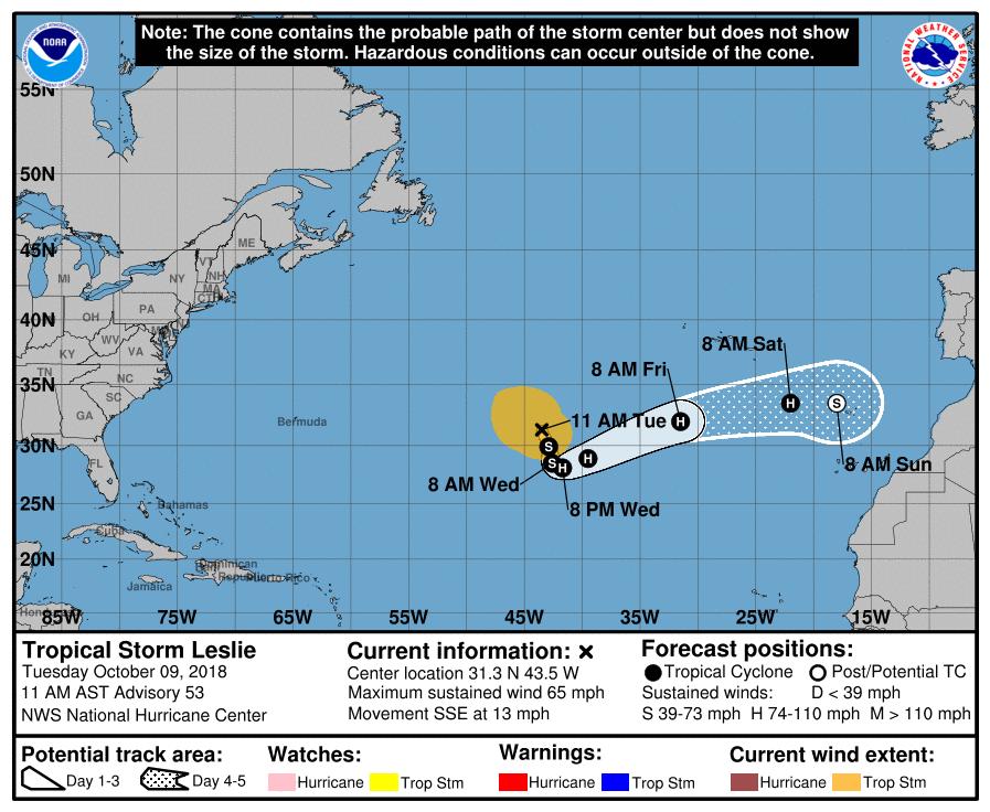
4 Leslie will move slowly southwestward over the next few days, but it will accelerate northeast again later this week. Leslie may strengthen to a hurricane when it moves southwest over warmer waters. Michael is currently forecast to strengthen to a Category 2 before landfall. 150 miles 330 miles

5 Tropical Storm Watch Tropical Storm Warning Hurricane Warning

6 NHC Cone + Chance of Hurricane Force Winds
 (all time eastern) Hurricane force winds approximately 6hrs")
7 Hurrevac Timing of onset of TS winds Wednesday (assumes a perfect forecast) (all time eastern) Hurricane force winds approximately 6hrs later

 (all")
8 Hurrevac Timing of onset of TS winds Wednesday (assumes a perfect forecast) (all times eastern)

9

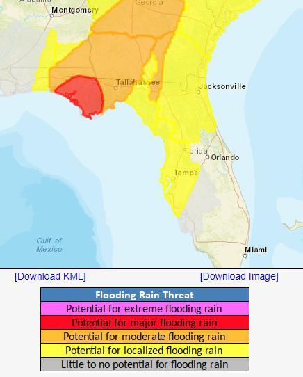
10 Forecast Cumulative Rain Totals Next 48 Hours Rain bands will begin impacting parts of the Panhandle, Big Bend, and West Coast today. Rain totals will be maximized east of where Michael tracks. A Flash Flood Watch is in effect for portions of the Big Bend and eastern Panhandle where 4-8 of rain is expected with isolated totals of possible.
")
11 Flash Flood Watch in effect (light green)

12 The risk for isolated tornadoes will increase as outer bands move onshore, especially to the northeast of the center of Michael.


13 Ocean swells will increase the rip current threat along the Panhandle coast and West Coast. Wave heights along the Panhandle and Big Bend may peak at at the beach and much higher offshore. Beach erosion likely. Forecast Wave Heights

14
15 Post-Storm High/Low Temperature Forecast - Thursday

16 Post-Storm High/Low Temperature Forecast - Friday
17 Post-Storm High/Low Temperature Forecast - Saturday
18

19 Nadine will move northwestward over the next few days. Weakening and dissipation is forecast this weekend.
20 Tropical Storm Leslie: Summary At 11 AM EDT Tuesday, Tropical Storm Leslie was located about in the central Atlantic Ocean with maximum sustained winds near 65 mph and moving south-southeast at 13mph. Leslie could become a hurricane later this week before turning toward the east-northeast toward Portugal. Tropical Storm Nadine: Tropical Depression #15 was upgraded to Tropical Storm Nadine in the eastern Atlantic Ocean with maximum sustained winds near 40 mph Some strengthening is forecast over the next couple days while moving northwest, but is forecast to dissipate this weekend. Hurricane Michael: As of 11 AM EDT Tuesday, Hurricane Michael was located about 335 miles south of Apalachicola, FL, and moving north at 12mph. Maximum sustained winds have increased to 110 mph, a Category 2 on the Saffir-Simpson Hurricane Wind Scale. Additional strengthening is expected, and Michael is expected to become a major hurricane later today. Landfall is expected in the Panhandle or Big Bend sometime on Wednesday. Tropical storm force winds extend up to 185 miles from the center and hurricane force winds extending up to 35 miles from the center.
21 Florida Outlook: The eastern Florida Panhandle and western Big Bend remain within the cone of error for landfall potential. An increase in water levels from Michael are already present and wave heights will continue to increase through Thursday morning. Tropical storm conditions may arrive in the Panhandle as soon as tonight but no later than late Wednesday morning. If the track shifts eastward or expands in size, the Florida West Coast could experience tropical storm force winds tonight or early tomorrow morning. Hurricane conditions should arrive in the Panhandle Wednesday afternoon or evening. Tropical Storm Wind Watches are in effect for 5 counties along the Florida West Coast, with a Tropical Storm Warning in effect for 10 counties in the eastern Big Bend, Suwannee Valley and Nature Coast. Hurricane Warnings are in effect for 18 Panhandle and Big Bend counties, including coastal portions of Taylor and Dixie. Storm surge will be one of the greatest impacts from this storm and may affect a large portion of the Florida Gulf Coast. Storm Surge Warnings have been issued between the Walton/Okaloosa border eastward to the Pasco/Pinellas County line for possible surge inundation of 6-9 for the eastern Panhandle coast and Nature Coast, and 8-12 for Apalachee Bay. Storm Surge Watches remain in effect for the western Panhandle and Tampa Bay region for possible surge values of 2-4. Widespread rainfall totals of 4-8 with locally higher amounts of can be expected across the Panhandle and Big Bend, with most of it occurring on Wednesday. Isolated tornadoes will be possible Wednesday across North Florida and even northern portions of Central Florida. Tornado Watches will likely be issued tomorrow. Ocean swells from Tropical Storm Leslie and breezy onshore winds from high pressure to the north of Florida will continue producing high risk of rip currents along all Atlantic beaches. Tropical Depression Nadine is not expected to affect Florida. Another briefing packet will be issued later this afternoon. For the latest information on the tropics, please visit the National Hurricane Center website at
22 Tropical Update Created by: Amy Godsey, Chief State Meteorologist State Meteorological Support Unit Florida Division of Emergency Management Users wishing to subscribe (approval pending) to this distribution list, register at _Tropics. Other reports available for subscription are available at
Tropical Update. 11 AM EDT Wednesday, October 10, 2018 Hurricane Michael, Hurricane Leslie & Tropical Storm Nadine, Caribbean Low (40%)
") Tropical Update 11 AM EDT Wednesday, October 10, 2018 Hurricane Michael, Hurricane Leslie & Tropical Storm Nadine, Caribbean Low (40%) This update is intended for government and emergency response officials,
Tropical Update 11 AM EDT Wednesday, October 10, 2018 Hurricane Michael, Hurricane Leslie & Tropical Storm Nadine, Caribbean Low (40%) This update is intended for government and emergency response officials,
Tropical Update. 5 AM EDT Monday, October 8, 2018 Tropical Storm Michael, Tropical Storm Leslie, Invest 92L (10%) & African Tropical Wave (50%)
 & African Tropical Wave (50%)") Tropical Update 5 AM EDT Monday, October 8, 2018 Tropical Storm Michael, Tropical Storm Leslie, Invest 92L (10%) & African Tropical Wave (50%) This update is intended for government and emergency response
Tropical Update 5 AM EDT Monday, October 8, 2018 Tropical Storm Michael, Tropical Storm Leslie, Invest 92L (10%) & African Tropical Wave (50%) This update is intended for government and emergency response
Tropical Update. 5 PM EDT Sunday, October 7, 2018 Tropical Storm Michael, Tropical Storm Leslie, & Invest 92L (30%)
") Tropical Update 5 PM EDT Sunday, October 7, 2018 Tropical Storm Michael, Tropical Storm Leslie, & Invest 92L (30%) This update is intended for government and emergency response officials, and is provided
Tropical Update 5 PM EDT Sunday, October 7, 2018 Tropical Storm Michael, Tropical Storm Leslie, & Invest 92L (30%) This update is intended for government and emergency response officials, and is provided
Tropical Update. 5 AM EDT Thursday, September 7, 2017 Hurricane Irma, Hurricane Jose, and Hurricane Katia
 Tropical Update 5 AM EDT Thursday, September 7, 2017 Hurricane Irma, Hurricane Jose, and Hurricane Katia This update is intended for government and emergency response officials, and is provided for informational
Tropical Update. 5 PM EDT Sunday, September 10, 2017 Hurricane Irma, Hurricane Jose, Tropical Wave (60%)
") Tropical Update 5 PM EDT Sunday, September 10, 2017 Hurricane Irma, Hurricane Jose, Tropical Wave (60%) This update is intended for government and emergency response officials, and is provided for informational
Tropical Update 5 PM EDT Sunday, September 10, 2017 Hurricane Irma, Hurricane Jose, Tropical Wave (60%) This update is intended for government and emergency response officials, and is provided for informational
Tropical Update. 5 PM EDT Thursday, September 7, 2017 Hurricane Irma, Hurricane Jose, and Hurricane Katia
 Tropical Update 5 PM EDT Thursday, September 7, 2017 Hurricane Irma, Hurricane Jose, and Hurricane Katia This update is intended for government and emergency response officials, and is provided for informational
Tropical Update. 5 AM EDT Wednesday, September 6, 2017 Hurricane Irma, Tropical Storm Jose, and Tropical Storm Katia
 Tropical Update 5 AM EDT Wednesday, September 6, 2017 Hurricane Irma, Tropical Storm Jose, and Tropical Storm Katia This update is intended for government and emergency response officials, and is provided
Tropical Update. 5 PM EDT Tuesday, September 5, 2017 Hurricane Irma, Tropical Storm Jose, and Tropical Depression Thirteen
 Tropical Update 5 PM EDT Tuesday, September 5, 2017 Hurricane Irma, Tropical Storm Jose, and Tropical Depression Thirteen This update is intended for government and emergency response officials, and is
Tropical Update. 5 AM EDT Tuesday, September 12, 2017 Post-Tropical Cyclone Irma, Hurricane Jose, & Tropical Wave (10%)
") Tropical Update 5 AM EDT Tuesday, September 12, 2017 Post-Tropical Cyclone Irma, Hurricane Jose, & Tropical Wave (10%) This update is intended for government and emergency response officials, and is provided
Tropical Update 5 AM EDT Tuesday, September 12, 2017 Post-Tropical Cyclone Irma, Hurricane Jose, & Tropical Wave (10%) This update is intended for government and emergency response officials, and is provided
Tropical Update 11 AM EDT Thursday, September 6, 2018 Tropical Depression Gordon, Hurricane Florence, Invest 92L (90%) & African Tropical Wave (50%)
 & African Tropical Wave (50%)") Tropical Update 11 AM EDT Thursday, September 6, 2018 Tropical Depression Gordon, Hurricane Florence, Invest 92L (90%) & African Tropical Wave (50%) This update is intended for government and emergency
Tropical Update 11 AM EDT Thursday, September 6, 2018 Tropical Depression Gordon, Hurricane Florence, Invest 92L (90%) & African Tropical Wave (50%) This update is intended for government and emergency
Atlantic Basin Satellite Image
 Tropical Update 11 AM EDT Friday, September 7, 2018 Tropical Depression Gordon, Tropical Storm Florence, Potential Tropical Cyclone #8 (90%), Invest 92L (90%) This update is intended for government and
Tropical Update. 1 PM EDT Monday, May 21, 2018 Caribbean Disturbance (20%)
") Tropical Update 1 PM EDT Monday, May 21, 2018 Caribbean Disturbance (20%) This update is intended for government and emergency response officials, and is provided for informational and situational awareness
Tropical Update 1 PM EDT Monday, May 21, 2018 Caribbean Disturbance (20%) This update is intended for government and emergency response officials, and is provided for informational and situational awareness
Tropical Update. 12 PM EDT Friday, October 7, 2016 Hurricane Matthew & Tropical Storm Nicole
 Tropical Update 12 PM EDT Friday, October 7, 2016 Hurricane Matthew & Tropical Storm Nicole This update is intended for government and emergency response officials, and is provided for informational and
Tropical Update 6 AM EDT Friday, October 7, 2016 Hurricane Matthew & Hurricane Nicole
 Tropical Update 6 AM EDT Friday, October 7, 2016 Hurricane Matthew & Hurricane Nicole This update is intended for government and emergency response officials, and is provided for informational and situational
GC Briefing. Weather Sentinel Tropical Storm Michael. Status at 8 AM EDT (12 UTC) Today (NHC) Discussion. October 11, 2018
 Today (NHC) Discussion. October 11, 2018") GC Briefing Weather Sentinel Tropical Storm Michael October 11, 2018 After making landfall as a high-end category-4 hurricane on the Florida Panhandle, Michael weakened to tropical storm status early this
GC Briefing Weather Sentinel Tropical Storm Michael October 11, 2018 After making landfall as a high-end category-4 hurricane on the Florida Panhandle, Michael weakened to tropical storm status early this
Tropical Update. 5 PM EDT Thursday, August 27, 2015 Tropical Storm Erika
 Tropical Update 5 PM EDT Thursday, August 27, 2015 Tropical Storm Erika This update is intended for government and emergency response officials, and is provided for informational and situational awareness
Major Hurricane Matthew Briefing Situation Overview
 Major Hurricane Matthew Briefing Situation Overview At 5 p.m. Tuesday, Category 4 Hurricane Matthew was about 860 miles South-Southeast of Mayport, Florida, moving north around 10 mph. Maximum sustained
Tropical Storm Harvey: SE Texas Impacts
 Tropical Storm Harvey: SE Texas Impacts 10 AM CDT UPDATE Thursday, August 24, 2017 Prepared by: Dan Reilly, Brian Kyle PLEASE MUTE YOUR LINES AND DON T PUT ON HOLD! Situation Overview Tropical Storm Harvey
GC Briefing. Weather Sentinel Hurricane Florence. Status at 5 PM EDT (21 UTC) Today (NHC) Discussion. September 13, 2018
 Today (NHC) Discussion. September 13, 2018") GC Briefing September 13, 2018 Weather Sentinel Hurricane Florence Tropical storm conditions have been reported for areas of North Carolina and will continue to spread inland to the west and south. Hurricane
GC Briefing September 13, 2018 Weather Sentinel Hurricane Florence Tropical storm conditions have been reported for areas of North Carolina and will continue to spread inland to the west and south. Hurricane
HURRICANE HARVEY COE Navigation BRIEFING
 HURRICANE HARVEY COE Navigation BRIEFING 10:00 AM CDT Friday, August 25, 2017 NWSNewOrleans www.weather.gov/neworleans Situation Overview New Information Harvey continues to strengthen Max sustained winds
TROPICAL STORM HARVEY BRIEFING
 TROPICAL STORM HARVEY BRIEFING 10:00 AM CDT Sunday, August 27, 2017 Prepared by: NWS LIX NWSNewOrleans www.weather.gov/neworleans Situation Overview New Information Tropical Storm Winds 40mph Immediate
TROPICAL STORM NATE BRIEFING
 TROPICAL STORM NATE BRIEFING 5:00 AM CDT Friday, October 6, 2017 Prepared by: NWS NWSNewOrleans www.weather.gov/neworleans Situation Overview No significant changes to the track forecast this morning.
Hurricane Matthew. Life Threatening Flash Flooding Likely. National Weather Service Wilmington NC. Josh Weiss, Meteorologist
 Hurricane Matthew Life Threatening Flash Flooding Likely Threat Assessment for northeast South Carolina & southeast North Carolina National Weather Service Wilmington NC 630 PM EDT Friday October 7, 2016
HURRICANE IRENE. CONFERENCE CALL BRIEFING SLIDES Saturday August 27, :30 AM
 HURRICANE IRENE CONFERENCE CALL BRIEFING SLIDES Saturday August 27, 2011 8:30 AM NHC TRACK AND CONE HURRICANE IRENE WATCHES/WARNINGS Hurricane Warning along south coast including all of Cape Cod and Islands
WEDNESDAY 30 TH AUGUST, :57 p.m. Tropical Storm Irma forms in the Atlantic. Don t let your guard down, always #Be Ready.
 Chapter 1 - The Set Up In the days leading up to Irma a series of composed and sobering text messages, presented in truncated form below, from Department of Disaster Management warned us of the pending
Hurricane Matthew Life Threatening Flash Flooding Likely
 Hurricane Matthew Life Threatening Flash Flooding Likely Threat Assessment for northeast South Carolina & southeast North Carolina National Weather Service Wilmington NC 12 AM EDT Saturday October 8, 2016
Hurricane Harvey: SE Texas Impacts. 10 PM CDT UPDATE Friday, August 25, 2017 Prepared by: Lance Wood
 Hurricane Harvey: SE Texas Impacts 10 PM CDT UPDATE Friday, August 25, 2017 Prepared by: Lance Wood Latest Observations Hurricane Harvey making landfall this evening near Rockport as a category 4 hurricane.
TROPICAL STORM HARVEY COE Navigation Call - Update
 TROPICAL STORM HARVEY COE Navigation Call - Update 10:00 AM CDT Tuesday, August 29, 2017 Prepared by: NWS LIX NWSNewOrleans www.weather.gov/neworleans Situation Overview New Information Drifting ENE at
TROPICAL DEPRESSION HARVEY BRIEFING
 TROPICAL DEPRESSION HARVEY BRIEFING 10:15 PM CDT Wednesday, August 23, 2017 Prepared by: Lara Beal NWSCorpus www.weather.gov/corpuschristi Situation Overview No changes to Watches. Hurricane Watch remains
TROPICAL STORM NATE BRIEFING
 TROPICAL STORM NATE BRIEFING 10:30 AM CDT Friday, October 06, 2017 Prepared by: NWS NWSNewOrleans www.weather.gov/neworleans Situation Overview Track forecast has shifted slightly eastward. Hurricane Watch
Hurricane Irma Page 1 HURRTRAK RM/Pro 2017 Summary Report for Tampa, FL 09/10/ EDT, Adv. # 46
 Hurricane Irma Page 1 Description of impact to Tampa, FL, Tampa, FL, is expected to receive a major impact from Hurricane Irma. The forecast maximum wind for this location has increased since the last
HURRICANE IRMA. 12 PM ET Saturday, September Prepared by: Kyle Thiem / Sid King.
 HURRICANE IRMA 12 PM ET Saturday, September 9 2017 Prepared by: Kyle Thiem / Sid King www.weather.gov/atlanta/briefings @NWSAtlanta www.weather.gov/atlanta Situation Overview 11:00 AM EDT Sat Sep 9 Location:
Hurricane Irma Page 1 HURRTRAK RM/Pro 2017 Summary Report for Tampa, FL 09/09/ EDT, Adv. # 43
 Hurricane Irma Page 1 Description of impact to Tampa, FL, Tampa, FL, is expected to receive a major impact from Hurricane Irma. The forecast maximum wind for this location has decreased since the last
TROPICAL STORM HARVEY BRIEFING
 TROPICAL STORM HARVEY BRIEFING 2:00 PM CDT Tuesday, August 29, 2017 Prepared by: NWS LIX NWSNewOrleans www.weather.gov/neworleans Situation Overview New Information Moving NNE Max sustained wind 45 mph
NOAA s National Weather Service Philadelphia/Mt. Holly NJ
 Next Briefing Package: Friday, October 2, 2015 no later than 300 PM Hazards and Impacts: Overview: A dangerous weather pattern still threatens our region. Threats include very heavy rainfall, inland river
Tropical Storm Ana. Created 6:00 AM Sun May 10, 2015 John Cole Warning Coordination Meteorologist
 Tropical Storm Ana Threat Assessment for Eastern North Carolina Created 6:00 AM Sun May 10, 2015 John Cole Warning Coordination Meteorologist John.cole@noaa.gov National Weather Service Newport/Morehead
Tropical Storm Ana. Created 615 AM Sat May 9, 2015 Reid Hawkins, Science Officer
 Tropical Storm Ana Threat Assessment for northeast South Carolina & southeast North Carolina Created 615 AM Sat May 9, 2015 Reid Hawkins, Science Officer National Weather Service Wilmington, NC 1 New Information
Storm Summary for Hurricane Joaquin
 Storm Summary for Hurricane Joaquin Wednesday, September 30, 2015 at 5 PM EDT (Output from Hurrevac, based on National Hurricane Center Forecast Advisory #12) Joaquin is currently a Category 1 hurricane
Florida Division of Emergency Management State Watch Office
 Florida Division of Emergency Management State Watch Office Morning Situation Report Monday, October 1, 2018 State Emergency Operations Center Activation Level Level 3 Monitoring SERT On-Call Personnel
Florida Division of Emergency Management State Watch Office
 Florida Division of Emergency Management State Watch Office Morning Situation Report Monday, October 8, 2018 State Emergency Operations Center Activation Level Level 1 Activation SERT On-Call Personnel
Hurricane Harvey: SE Texas Impacts. 10 AM CDT UPDATE Saturday, August 26, 2017 Prepared by: Dan Reilly, Brian Kyle
 Hurricane Harvey: SE Texas Impacts 10 AM CDT UPDATE Saturday, August 26, 2017 Prepared by: Dan Reilly, Brian Kyle Latest Observations and Radar Hurricane Harvey centered near Victoria and weakening Wind
Major Hurricane Earl
 Major Hurricane Earl Advisory 32 North Carolina Threat Assessment Prepared at: 8 AM Thursday September 2, 2010 Hurricane and Tropical Storm Warnings in effect for the North Carolina Coast and Sounds. NWS
Storm Summary for Hurricane Jose
 Storm Summary for Hurricane Jose Tuesday, September 19, 2017 at 11 AM EDT (Output from Hurrevac, based on National Hurricane Center Forecast Advisory #57) Jose is currently a Category 1 hurricane on the
TROPICAL STORM NATE BRIEFING
 TROPICAL STORM NATE BRIEFING 2:00 PM CDT Friday, October 06, 2017 Prepared by: NWS NWSNewOrleans www.weather.gov/neworleans Situation Overview Track forecast has not changed since the 10 am advisory. Hurricane
HURRICANE NATE BRIEFING
 HURRICANE NATE BRIEFING 2:00 PM CDT Saturday, October 07, 2017 Prepared by: NWS NWSNewOrleans www.weather.gov/neworleans Situation Overview continues to intensify. It is now forecast to be a category 2
Current Details from the National Hurricane Center (NHC)
") Current Watches and Warnings A Warning is in effect from Anclote River to the Okaloosa/Walton County Line; north of the Volusia/Brevard County line to the South Santee River A Surge Warning is in effect
Current Watches and Warnings A Warning is in effect from Anclote River to the Okaloosa/Walton County Line; north of the Volusia/Brevard County line to the South Santee River A Surge Warning is in effect
Florida Division of Emergency Management State Watch Office
 Florida Division of Emergency Management State Watch Office Morning Situation Report Wednesday, November 7, 2018 State Emergency Operations Center Activation Level Level 2 Activation SERT On-Call Personnel
Significant Flooding Expected
 Significant Flooding Expected Decision Support Briefing #5 As of: 9:00 AM September 14, 2018 What Has Changed? Flash Flood Watch now in effect for part of area, will be expanded later today 9/14/2018 9:23
Subtropical Storm Ana
 Subtropical Storm Ana Threat Assessment for northeast South Carolina & southeast North Carolina Created 745 AM Fri May 8, 2015 Reid Hawkins, Science Officer National Weather Service Wilmington, NC 1 New
Hurricane Matthew Page 1 Location Forecast Analysis Summary Report - Advanced Wind Estimation On
 Page 1 Current NHC Forecast Predictions Maximum Sustained Winds / Storm Category: 138 MPH / Category 4 Forward motion: 9 mph towards the North Hurricane Force winds extend from the center: 46 miles Tropical
Prolonged Coastal Storm October 9 th -12 th, 2013
 Prolonged Coastal Storm October 9 th -12 th, 2013 Prepared 400 PM EDT Tuesday, October 8th, 2013 Gary Szatkowski NOAA s NJ Forecast office http://www.erh.noaa.gov/phi/ Purpose of Briefing Briefing #1 for
Tropical Weather Briefing
 Tropical Weather Briefing August 28, 2012 700 AM CDT National Weather Service Weather Forecast Office Slidell, LA Current Satellite Tropical Storm Isaac Watches/Warnings Tropical Storm Isaac Track Guidance
NOAA s National Weather Service Philadelphia/Mt. Holly NJ
 Next Briefing Package: Thursday, October 1, 2015 no later than 300 PM Hazards and Impacts: Overview: A dangerous weather pattern is developing for our region. Threats include very heavy rainfall, inland
Wind field has expanded and is very large. Hurricane Wind field = 100 miles wide, Tropical Storm Wind field = 360 miles wide
 HURRICANE IRMA 12 PM ET Sunday, September 10 2017 Prepared by: Keith Stellman / Kyle Thiem www.weather.gov/atlanta/briefings @NWSAtlanta www.weather.gov/atlanta Situation Overview 11:10 AM EDT Sun Sep
Current Details from the National Hurricane Center (NHC)
") Current Watches and Warnings A Hurricane Warning is in effect from Port Mansfield to Sargent, Texas A Warning is in effect from north of Sargent to High Island, Texas A Surge Warning is in effect from
Current Watches and Warnings A Hurricane Warning is in effect from Port Mansfield to Sargent, Texas A Warning is in effect from north of Sargent to High Island, Texas A Surge Warning is in effect from
What s s New for 2009
 What s s New for 2009 Graphical Tropical Weather Outlook becomes operational Special Tropical Disturbance Statement replaced with Special Tropical Weather Outlook Tropical Cyclone Wind Field Graphic becomes
Current Details from the National Hurricane Center (NHC)
") Current Watches and Warnings A Hurricane Warning is in effect from South Santee River, South Carolina (SC) to Duck, North Carolina (NC); Albemarle and Pamlico Sounds A Hurricane Watch is in effect from
Current Watches and Warnings A Hurricane Warning is in effect from South Santee River, South Carolina (SC) to Duck, North Carolina (NC); Albemarle and Pamlico Sounds A Hurricane Watch is in effect from
Florida Division of Emergency Management State Watch Office
 Florida Division of Emergency Management State Watch Office Morning Situation Report Wednesday, October 24, 2018 State Emergency Operations Center Activation Level Level 2 Activation SERT On-Call Personnel
Florida Division of Emergency Management State Watch Office
 Florida Division of Emergency Management State Watch Office Morning Situation Report Wednesday, November 21, 2018 State Emergency Operations Center Activation Level Level 3 Monitoring SERT On-Call Personnel
National Hurricane Center Products. Jack Beven National Hurricane Center
 National Hurricane Center Products Jack Beven National Hurricane Center Florida Governor s Hurricane Conference 11 May 2014 NHC Tropical Cyclone Products NHC provides the big picture that complements and
Coastal Storm. Wednesday through Friday, 3/6-8/2013 Weather Briefing
 Coastal Storm Wednesday through Friday, 3/6-8/2013 Weather Briefing Prepared 2:00 PM EST Wednesday, March 6, 2013 National Weather Service New York, NY Purpose of Briefing Promote Situational Awareness
Tropical Storm Harvey: SE Texas Impacts. 10 AM CDT UPDATE Sunday August 27, 2017 Prepared by: Lance Wood
 Tropical Storm Harvey: SE Texas Impacts 10 AM CDT UPDATE Sunday August 27, 2017 Prepared by: Lance Wood Situation Overview Catastrophic flooding is ongoing with flash flood emergencies remaining in effect.
Storm Surge Forecast with Shifting Forecast Tracks
 Storm Surge Forecast with Shifting Forecast Tracks Storm Surge Findings in the Florida Keys Jon Rizzo Warning Coordination Meteorologist National Weather Service Florida Keys Florida Keys Life History
Current Details from the National Hurricane Center (NHC)
") Current Watches and Warnings A Hurricane Warning is in effect from Port Mansfield to Sargent, Texas A Warning is in effect from north of Sargent to High Island, Texas; south of Port Mansfield, Texas to
Current Watches and Warnings A Hurricane Warning is in effect from Port Mansfield to Sargent, Texas A Warning is in effect from north of Sargent to High Island, Texas; south of Port Mansfield, Texas to
Major Hurricane Matthew Briefing Situation Overview
 Major Hurricane Matthew Briefing Situation Overview THIS IS NOW A WORST CASE STORM SURGE SCENARIO Catastrophic Damage is Anticipated for Coastal Areas. Major Hurricane Matthew is still expected to move
Hurricane Matthew Threats and Impacts Briefing for Eastern NC
 Hurricane Matthew Threats and Impacts Briefing for Eastern NC October 6 th, 2016 Date/Time Created: 10/6/2016, Noon EDT National Weather Service Newport/Morehead City, NC Hurricane Matthew Key Points Changes
Hurricane Matthew. National Weather Service Wilmington NC. Steven Pfaff, WCM.
 Hurricane Matthew Threat Assessment for northeast South Carolina & southeast North Carolina National Weather Service Wilmington NC 730 AM EDT Tuesday October 4, 2016 Steven Pfaff, WCM Steven.Pfaff@noaa.gov
Saturday, October 6, :30 a.m. EDT
 Saturday, October 6, 2018 8:30 a.m. EDT Significant Activity Oct 5-6 Significant Events: None Tropical Activity: Atlantic Tropical Storm Leslie; Disturbance 1 (High: 90%) Eastern Pacific Hurricane Sergio
Monday, October 8, :30 a.m. EDT
 Monday, October 8, 2018 8:30 a.m. EDT Significant Activity Oct 7-8 Significant Events: Tropical Storm Michael Preparation Tropical Activity: Atlantic Tropical Storm Leslie; Tropical Storm Michael; Disturbance
Hurricane Matthew. National Weather Service Wilmington NC. Steven Pfaff, WCM.
 Hurricane Matthew Threat Assessment for northeast South Carolina & southeast North Carolina National Weather Service Wilmington NC 515 PM EDT Monday October 3, 2016 Steven Pfaff, WCM Steven.Pfaff@noaa.gov
Current Details from the National Hurricane Center (NHC)
") Current Watches/Warnings A Hurricane Warning is in effect from Surf City, North Carolina to the North Carolina/Virginia border; Pamlico Sound; Eastern Albemarle Sound A Hurricane Watch is in effect from
Current Watches/Warnings A Hurricane Warning is in effect from Surf City, North Carolina to the North Carolina/Virginia border; Pamlico Sound; Eastern Albemarle Sound A Hurricane Watch is in effect from
Current Details from the National Hurricane Center (NHC)
") Current Watches and Warnings A Hurricane Warning is in effect from South Santee River, South Carolina (SC) to Duck, North Carolina (NC); Albemarle and Pamlico Sounds A Hurricane Watch is in effect from
Current Watches and Warnings A Hurricane Warning is in effect from South Santee River, South Carolina (SC) to Duck, North Carolina (NC); Albemarle and Pamlico Sounds A Hurricane Watch is in effect from
Satellite and Radar. 5:55 am Infrared Satellite with Surface Wind Arrows. 6:15 am Ruskin Doppler Radar. Large southerly wind field
 Satellite and Radar 5:55 am Infrared Satellite with Surface Wind Arrows 6:15 am Ruskin Doppler Radar Large southerly wind field Developing showers rotating onshore NHC Forecast Hurricane Warning Big Bend
National Situation Report As of 3:00 a.m. EDT, Thursday, September 21, 2017 Table of Contents Current Operations Monitoring Recovery
 25k Overview National Situation Report As of 3:00 a.m. EDT, Thursday, September 21, 2017 Table of Contents Current Operations Monitoring Recovery FEMA Headquarters Status FEMA Region Status NRCC Level
Florida Division of Emergency Management State Watch Office
 Florida Division of Emergency Management State Watch Office Morning Situation Report Tuesday, March 5, 2019 State Emergency Operations Center Activation Level Level 3 Monitoring SERT On-Call Personnel
Florida Division of Emergency Management State Watch Office
 Florida Division of Emergency Management State Watch Office Morning Situation Report Saturday, December 1, 2018 State Emergency Operations Center Activation Level Level 3 Monitoring SERT On-Call Personnel
Current Details from the National Hurricane Center (NHC)
") Current Watches and Warnings A Warning is in effect from South Santee River, South Carolina to Cape Lookout, North Carolina; Pamlico Sound A Surge Warning is in effect from Myrtle Beach, South Carolina
Current Watches and Warnings A Warning is in effect from South Santee River, South Carolina to Cape Lookout, North Carolina; Pamlico Sound A Surge Warning is in effect from Myrtle Beach, South Carolina
An upper to mid level circulation (Low) in the NW Caribbean is
 in the NW Caribbean is") WEEKLY WEATHER OUTLOOK BELIZE, CENTRAL AMERICA PERIOD: Monday-Monday, Oct. 1 October 8, 2012 DATE ISSUED: Monday, Oct 1, 2012 6:00 am RFrutos EcoSolutions & Services SYNOPSIS: An upper to mid level circulation
WEEKLY WEATHER OUTLOOK BELIZE, CENTRAL AMERICA PERIOD: Monday-Monday, Oct. 1 October 8, 2012 DATE ISSUED: Monday, Oct 1, 2012 6:00 am RFrutos EcoSolutions & Services SYNOPSIS: An upper to mid level circulation
Florida Division of Emergency Management State Watch Office
 Florida Division of Emergency Management State Watch Office Morning Situation Report Saturday, January 19, 2019 State Emergency Operations Center Activation Level Level 3 Monitoring SERT On-Call Personnel
Current Details from the National Hurricane Center (NHC)
") Current Watches and Warnings A Hurricane Warning is in effect from Fernandina Beach southward around the Florida peninsula to Indian Pass; Florida Keys; Lake Okeechobee; Florida Bay A Hurricane Watch is
Current Watches and Warnings A Hurricane Warning is in effect from Fernandina Beach southward around the Florida peninsula to Indian Pass; Florida Keys; Lake Okeechobee; Florida Bay A Hurricane Watch is
There is a Storm. What s the Info? National Weather Service Tropical Cyclone Products
 NHC Forecasts There is a Storm. What s the Info? National Weather Service Tropical Cyclone Products National Weather Service Tropical Cyclone Products NHC provides the big picture that complements and
Florida Division of Emergency Management State Watch Office
 Florida Division of Emergency Management State Watch Office Morning Situation Report Wednesday, January 23, 2019 State Emergency Operations Center Activation Level Level 3 Monitoring SERT On-Call Personnel
Hurricane Michael Analysis
 10.10.18 Analysis Risk Services Division Legal Notice All consulting services performed by HUB are advisory in nature. All resultant reports are based upon conditions and practices observed by HUB and
RSMC-Miami Update Daniel Brown Warning Coordination Meteorologist
 RSMC-Miami Update 2016 Daniel Brown Warning Coordination Meteorologist L-0324 Emergency Management Hurricane Preparedness Training Course Funding provided by FEMA s National Hurricane Program - partnership
Weather Briefing Mixed Winter Storm Event February 26-27, 2013
 Weather Briefing Mixed Winter Storm Event February 26-27, 2013 Prepared 1200 PM EST Tuesday, February 26th, 2013 Joe Miketta NOAA s NJ Forecast Office http://www.erh.noaa.gov/phi/ Purpose of Briefing Briefing
Florida Division of Emergency Management State Watch Office
 Florida Division of Emergency Management State Watch Office Morning Situation Report Tuesday, February 12, 2019 State Emergency Operations Center Activation Level Level 3 Monitoring SERT On-Call Personnel
Florida Division of Emergency Management State Watch Office
 Florida Division of Emergency Management State Watch Office Morning Situation Report Sunday, December 9, 2018 State Emergency Operations Center Activation Level Level 3 Monitoring SERT On-Call Personnel
WEEKLY WEATHER OUTLOOK BELIZE, CENTRAL AMERICA
 WEEKLY WEATHER OUTLOOK BELIZE, CENTRAL AMERICA PERIOD: Sunday, June 17 until Monday, June 25, 2012 DATE ISSUED: Sunday, June 17, 2012; 3:00 pm RFrutos EcoSolutions & Services SYNOPSIS: An upper level trough
Active Weather Threat Halloween Week Nor easter October 28 th 31 st 2012
 Active Weather Threat Halloween Week Nor easter October 28 th 31 st 2012 Prepared 1130 AM EDT Wednesday, October 24, 2012 Gary Szatkowski NOAA s NJ Forecast Office Weather.gov/phi Purpose of Briefing Briefing
Weather briefing Strong Coastal Nor easter November 7 th -8 th, 2012
 Weather briefing Strong Coastal Nor easter November 7 th -8 th, 2012 Prepared 1245 PM EDT Tuesday November 6, 2012 Gary Szatkowski NOAA s NJ Forecast Office Weather.gov/phi Purpose of Briefing Briefing
Severe Weather Potential for Southeast Texas
 Severe Weather Potential for Southeast Texas Dan Reilly, Kent Prochazka, Scott Overpeck National Weather Service Houston/Galveston 10 am Synopsis Storm to likely bring severe weather to Southeast Texas
Daily Operations Briefing Thursday, September 29, :30 a.m. EDT
 Daily Operations Briefing Thursday, September 29, 2016 8:30 a.m. EDT Significant Activity - Sept 28-29 Significant Events: Midwest Flooding Tropical Activity: Atlantic Tropical Storm Matthew Eastern Pacific
Current Details from the National Hurricane Center (NHC)
") Current Watches and Warnings A Hurricane Warning is in effect from South Santee River, South Carolina (SC) to Bogue Inlet, North Carolina (NC); Pamlico Sound A Hurricane Watch is in effect from Edisto
Current Watches and Warnings A Hurricane Warning is in effect from South Santee River, South Carolina (SC) to Bogue Inlet, North Carolina (NC); Pamlico Sound A Hurricane Watch is in effect from Edisto
Florida Division of Emergency Management State Watch Office
 Florida Division of Emergency Management State Watch Office Morning Situation Report Thursday, February 14, 2019 State Emergency Operations Center Activation Level Level 3 Monitoring SERT On-Call Personnel
National Situation Report As of 5:00 a.m. EDT Tuesday, April 4, 2017
 Overview National Situation Report As of 5:00 a.m. EDT Tuesday, April 4, 2017 Table Of Contents Current Operations Monitoring Recovery National Response Coordination Center: Not Activated National Watch
photo courtesy of
 BRITISH VIRGIN ISLANDS REPORT TROPICAL STORM JEANNE photo courtesy of www.bviplatinum.com PREPARED BY THE DEPARTMENT OF DISASTER MANAGEMENT 1 EVENT 13 th -16 th September, 2004 TROPICAL STORM JEANNE Sequence
Tropical Storm Colin Briefing Last Briefing on this System
 Tropical Storm Colin Briefing Last Briefing on this System NWS WFO Jacksonville, Florida Tuesday, June 07, 2016 6:00 a.m. EDT Tropical Storm Colin s Impacts SE Georgia & North Florida Local Watches & Warnings:
Coastal Storm Potential
 Coastal Storm Potential Event Date/Time: 11/12/2009-11/14/2009 Today through Saturday National Weather Service Newport/Morehead City, NC Date: 11/12/2009 1000 am Coastal Storm Remnants of Ida, coupled
Major Hurricane Earl
 Major Hurricane Earl Advisory 33 North Carolina Threat Assessment Prepared at: 11 AM Thursday September 2, 2010 Hurricane and Tropical Storm Warnings in effect for the North Carolina Coast and Sounds NWS
Florida Division of Emergency Management State Watch Office
 Florida Division of Emergency Management State Watch Office Morning Situation Report Sunday, January 20, 2019 State Emergency Operations Center Activation Level Level 3 Monitoring SERT On-Call Personnel