Investigation of possible tsunami events on the eastern coast of Taiwan: case studies of Lu-Ye, Changping, and Tulan
|
|
|
- Godfrey Maxwell
- 5 years ago
- Views:
Transcription
1 Investigation of possible tsunami events on the eastern coast of Taiwan: case studies of Lu-Ye, Changping, and Tulan Speaker : FX. Anjar Tri Laksono Adviser : Louis Loung-Yie Tsai Date : October 19,
2 Outline Study area and geological background The location of sampling sites Aims of this study Literature review The result of previous studies. Geological, topographic, and bathymetric maps. Data description Earthquake records Primary data Methodology Preliminary result Conclusion 2


3 Study area and geological background N Fig.1. Location of the study area on the map (Google Earth, 2017) 3
4 Aims of this study Three aims of investigation of possible tsunami events on the eastern coast of Taiwan: To understand the history of tsunami on the eastern coast of Taiwan (age, frequency, and period). To determine the distribution pattern of tsunami sediment layers. To describe inundation distance, run-up, and flow height. 4
5 Literature Review The results of research A big sea wave struck Chenggong in 1850 AD. There were no tsunami deposit on marine terraces of Chenggong. There were tsunami deposits on marine terraces of Chenggong. Chenggong tsunami occurred in It was related to the 1771 tsunami south of Ishigaki Island. Three coral boulders were found resting on the Holocene coral terrace on the Jiupeng coast. Paleotsunamis occurred several times since the mid- Holocene high stand of sea level. References Abe, 1938, as cited in Ando et al., 2013 Hsieh and Rau, 2009, as cited in Lallemand et al., 2016 Ota et al., 2011 Ando et al., 2013 Matta, 2013 Ota et al.,
6 The comparison of tsunami research on eastern coast of Taiwan between previous studies and this study Previous studies Recent study Simulation approach (Ando et al., 2013) Observation and experiment approaches Boulder analysis study (Matta, 2013; Ota et al., 2015). Marine terrace deposits Study area in offshore (Lallemand et al., 2016) Study area in onshore 6
 Geological map of the Coastal")
 Topographic and bathymetric")
7 N (A) (B) Fig.2. (A) Geological map of the Coastal Range (Chen and Wang, 1997). (B) Topographic and bathymetric maps (Lallemand et al., 1997) 7
8 Data Description Data Primary data Advanced data Outcrops observation Sedimentary rocks Regional geology Topography and bathymetry maps Earthquake records 8

9 Earthquake Records Table 1. Earthquake and tsunami records in Taiwan since 1677-present (USGS, 2017). 9
 (B) Fig. 3.")

10 Primary Data Marine sand deposit (A) (B) Fig. 3. (A) Outcrop and (B) a sample of sedimentary rock at sampling site 20 (Tulan area). 10

 Beach")

 Fig.")

.")
11 Methodology Marine sand Beach sand (Fig. 11 D) Beach gravel Fluvial gravel and transported material (A) Fig. 4.(A) Observation at site 14 (Lu-Ye area). (B) Sand composition counting experiment (B) 11

12 Fig. 5. Fiji and ProSim free softwares for petrography analysis 12
")
 Solid")


13 (A) Loose sediments (B) Shaker machine (C) Solid microscope (E) Planktonic foraminifera (E) Planktonic foraminifera in the glass Fig. 6. Fossil analysis processes 13
 Beach gravel Fluvial gravel")
 (B) Fig. 7.")
14 Preliminary Results North North Beach gravel Marine sand (target) Fluvial gravel Marine sand (target) Beach gravel Fluvial gravel Alluvial fan Alluvial fan (A) Modern nearshore sand (Fig. 11 B) (B) Fig. 7. Marine terraces at sampling site 1 (A) and 13 (B) Lu-Ye. 14

 very coarse sand, (C) coarse sand, (D)")
15 North E D C B A A Fig.8. The intercalation between marine sand, fluvial gravel, and beach gravel at sampling site 24 (Changping). (A). Medium sand, (B) very coarse sand, (C) coarse sand, (D) beach gravel, (E) fluvial gravel. 15
 Fig. 9.")

16 Beach sand (Fig. 11 C) Fig. 9. Marine terrace at sampling site 25 (Changping Harbour area). 16

 Debris-flow")


17 Beach gravel Mud Debris-flow gravel Beach gravel (Fig. 11 A) Tsunami sediment candidate (B) Debris-flow gravel (A) (C) Fig. 10. Marine terrace at sampling site 26 (A), 29 (B), and coral boulder at sampling site 15 (C), Changping.


18 Pelecypod shell Fig. 10. Mollusca shells at marine terrace of Tulan (sampling site 19). 18
 Lm Fig. 11.")
, 13 (B),")


19 Qp Ls Qp PX Qm Qp Qp (A) (B) Qp Lm Qp Qp Qp Qp (C) Lm Fig. 11. Thin sections of sedimentary rock from sampling sites 29 (A), 13 (B), 25 (C), and 14 (D). Qp: polycrystalline quartz, Qm: monocrystalline quartz, : volcanic rock fragment, PX: Pyroxene, and Lm: metamorphic rock fragment. (D) Qp 19

20 Fig. 12. Sand composition counting from Lu-Ye (sampling sites 1 and 13) and Changping (sampling sites 3, 8, 9, and 12). 20

 Neogloboquadrina dutertrei, (B) Orbulina")
 Uvigerina")
21 Chamber Chamber (A) Suture (B) (C) Suture Suture Suture Suture Chamber Chamber Chamber (D) Fig. 13. (A) Neogloboquadrina dutertrei, (B) Orbulina universa, (C) Globigerinoides ruber, (D) Trilobatus sacculifer, (E) Uvigerina auberiana, (F) Globigerinoides diminutus (E) (F) 21
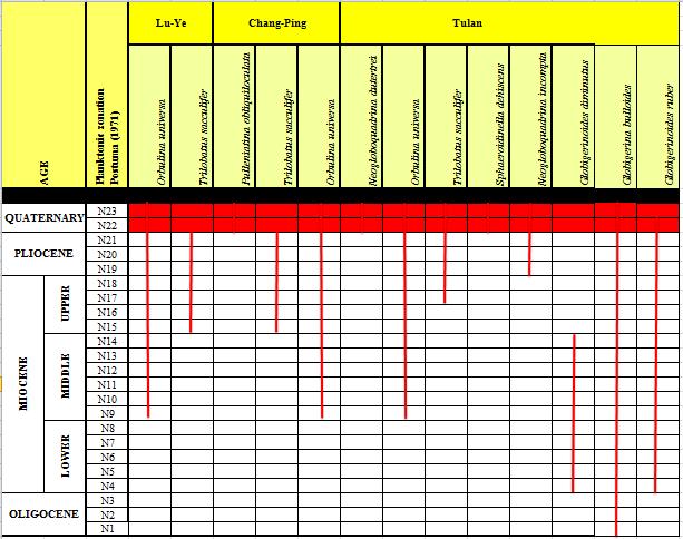
22 Biozonation 22

23 Paleobathymetry 23

24 Fig. 14. Marine zone (Nagy et al., 2000). 24
25 Conclusions There are 5 facies: alluvial fan, fluvial gravel, beach sand, beach gravel, and marine sand. Biozonation analysis exhibits that the age of marine deposits in Lu-Ye, Changping, and Tulan are Pleistocene-Holocene. Paleobathymetry of marine sand deposits depicts outer neritic. There were some super flood event deposits on the marine terraces of Lu-Ye, Changping, and Tulan. 25
26 Future Works Sand composition counting on marine terraces of northern Changping and Tulan. Construct stratigraphic columns. Classify the type of super flood events. Identify the age of super flood events (using carbon dating data). Inundation distance, run-up, and flow height descriptions. 26

27 27
A~3000 years-old sequence of extreme revealed by marine and shore deposits east of Taiwan Serge Lallemand, Remi Lehu, Fabien Retif, Shu-Kun Hsu,
 A~3000 years-old sequence of extreme revealed by marine and shore deposits east of Taiwan Serge Lallemand, Remi Lehu, Fabien Retif, Shu-Kun Hsu, Nathalie Babonneau, Gueorgui Ratzov, Maria-Angella Basseti,
THE DEPOSITS OF TSUNAMIS WESLEY PESANTEZ, CATHERINE NIELD, COLIN WINTER
 THE DEPOSITS OF TSUNAMIS WESLEY PESANTEZ, CATHERINE NIELD, COLIN WINTER AN OVERVIEW OF OUR SEMINAR WHAT IS A TSUNAMI WHY STUDY TSUNAMIS PROPERTIES OF TSUNAMIS TSUNAMI HYDRODYNAMICS IDEALIZED DEPOSITS SEDIMENT
Sediment erosion, resuspension, transportation and redeposition by tsunami: Evidences from the 2011 Tohoku-oki tsunami
 Paleotsunami Workshop 3 July 2013 Sediment erosion, resuspension, transportation and redeposition by tsunami: Evidences from the 2011 Tohoku-oki tsunami Ken Ikehara, Kazuko Usami (Geological Survey of
GEOLOGY MEDIA SUITE Chapter 5
 UNDERSTANDING EARTH, SIXTH EDITION GROTZINGER JORDAN GEOLOGY MEDIA SUITE Chapter 5 Sedimentation Rocks Formed by Surface Processes 2010 W.H. Freeman and Company Mineralogy of sandstones Key Figure 5.12
CHAPTER 1 INTRODUCTION
 1 CHAPTER 1 INTRODUCTION 1.1 GENERAL Washover sandsheets are often found in low-lying coastal embayment s (Sedgwick and Davis 2003). Washover deposition of marine sand is usually attributed to storm activity
Marine Sediments. Introductory Oceanography. Ray Rector: Instructor
 Marine Sediments Introductory Oceanography Ray Rector: Instructor Ocean Basins are Vast Sinks for Huge Amounts of Sediment from Numerous Different Sources Four Major Types of Seafloor Sediments 1. Lithogenous
GY 402: Sedimentary Petrology
 UNIVERSITY OF SOUTH ALABAMA GY 402: Sedimentary Petrology Lecture 13: Immature Siliciclastic Sedimentary Environments Alluvial Fans, Braided Streams Instructor: Dr. Douglas W. Haywick Last Time Immature
3.1 GEOLOGY AND SOILS Introduction Definition of Resource
 3.1 GEOLOGY AND SOILS 3.1.1 Introduction 3.1.1.1 Definition of Resource The geologic resources of an area consist of all soil and bedrock materials. This includes sediments and rock outcroppings in the
Chapter 10. Chapter Rocks and the Rock Cycle. Rocks. Section 1 Rocks and the Rock Cycle
 Chapter 10 Rocks 1 Chapter 10 Section 1 Rocks and the Rock Cycle 2 10.1 Rocks and the Rock Cycle Magma is the parent material for all rocks. Once the magma cools and hardens, many changes can occur. Geology:
NAME: GEL 109 Final Study Guide - Winter 2008 Questions 6-24 WILL be on the final exactly as written here; this is 60% of the test.
 GEL 109 Final Study Guide - Winter 2008 Questions 6-24 WILL be on the final exactly as written here; this is 60% of the test. 1. Sketch a map view of three types of deltas showing the differences in river,
Sediment and Sedimentary rock
 Sediment and Sedimentary rock Sediment: An accumulation of loose mineral grains, such as boulders, pebbles, sand, silt or mud, which are not cemented together. Mechanical and chemical weathering produces
GCE AS/A level 1211/01 GEOLOGY GL1 Foundation Unit
 Surname Centre Number Candidate Number Other Names 2 GCE AS/A level 1211/01 GEOLOGY GL1 Foundation Unit A.M. TUESDAY, 13 May 2014 1 hour For s use Question Maximum Mark 1. 17 2. 14 Mark Awarded 1211 010001
Sediment and sedimentary rocks Sediment
 Sediment and sedimentary rocks Sediment From sediments to sedimentary rocks (transportation, deposition, preservation and lithification) Types of sedimentary rocks (clastic, chemical and organic) Sedimentary
Lab 7: Sedimentary Structures
 Name: Lab 7: Sedimentary Structures Sedimentary rocks account for a negligibly small fraction of Earth s mass, yet they are commonly encountered because the processes that form them are ubiquitous in the
Sediment. Weathering: mechanical and chemical decomposition and disintegration of rock and minerals at the surface
 Sediment Some basic terminology Weathering: mechanical and chemical decomposition and disintegration of rock and minerals at the surface Erosion: removal of weathered rock and minerals from one place to
Pre-Lab Reading Questions ES202
 ES202 The are designed to encourage students to read lab material prior to attending class during any given week. Reading the weekly lab prior to attending class will result in better grade performance
Depositional Environments. Depositional Environments
 Depositional Environments Geographic area in which sediment is deposited Characterized by a combination of geological process & environmental conditions Depositional Environments Geological processes:
DATA REPOSITORY MATERIAL: PALEOCHANNEL GROUP MAPPING DESCRIPTIONS
 Data Repository item 2695 DATA REPOSITORY MATERIAL: PALEOCHANNEL GROUP MAPPING DESCRIPTIONS Groups 1 (North Myrtle Beach) and 2 (Atlantic Beach) Channel Groups 1 (North Myrtle Beach) and 2 (Atlantic Beach)
Reading Material. See class website. Sediments, from Oceanography M.G. Gross, Prentice-Hall
 Reading Material See class website Sediments, from Oceanography M.G. Gross, Prentice-Hall Materials filling ocean basins Dissolved chemicals especially from rivers and mid-ocean ridges (volcanic eruptions)
From the mountains to the ocean
 Background From the mountains to the ocean Using Google Earth and Ocean Cores to discover the concept of erosion and sediment transportation In 2004, a magnitude >9 earthquake struck North Sumatra and
INTRODUCTION. Climate
 INTRODUCTION Climate Landslides are serious natural disasters in many parts of the world. Since the past 30 years, rainfall triggered landslides and debris flows had been one of the natural disasters of
UK Field Training Courses
 UK Field Training Courses Bespoke courses for E&P companies For individual companies and/or partnerships Reservoir and exploration sedimentology oriented Integrated with company sedimentologist if desired
Depositional Environment
 Depositional Environment Sedimentary depositional environment describes the combination of physical, chemical and biological processes associated with the deposition of a particular type of sediment. Types
Beach Pebbles Tell a Story
 Maine Geologic Facts and Localities September, 2000 Text by Joseph T. Kelley, Department of Agriculture, Conservation & Forestry 1 Introduction The smooth, sandy beaches of southern Maine are popular with
Holocene evolution of Dahab coastline Gulf of Aqaba, Sinai Peninsula, Egypt 1
 Holocene evolution of Dahab coastline Gulf of Aqaba, Sinai Peninsula, Egypt 1 Magdy Torab* 2 * Prof. of Geomorphology, Department of Geography, Damanhour University, Egypt 3 E-mail: magdytorab@hotmail.com.
The 1700/01/26 Cascadia subduction zone Earthquake and Tsunami
 Jason R. Patton GEO 142 1/13/15 Abstract: Cascadia subduction zone earthquakes (CSZ) can generate strong ground shaking and deadly tsunamis. Geologists used sediment cores and stream bank exposures to
A multi-proxy study of planktonic foraminifera to identify past millennialscale. climate variability in the East Asian Monsoon and the Western Pacific
 This pdf file consists of all pages containing figures within: A multi-proxy study of planktonic foraminifera to identify past millennialscale climate variability in the East Asian Monsoon and the Western
TAKE HOME EXAM 8R - Geology
 Name Period Date TAKE HOME EXAM 8R - Geology PART 1 - Multiple Choice 1. A volcanic cone made up of alternating layers of lava and rock particles is a cone. a. cinder b. lava c. shield d. composite 2.
454/01 GEOLOGY GL4 INTERPRETING THE GEOLOGICAL RECORD. A.M. MONDAY, 12 June (2 Hours)
") Candidate Name Centre Number Candidate Number WELSH JOINT EDUCATION COMMITTEE General Certificate of Education Advanced CYD-BWYLLGOR ADDYSG CYMRU Tystysgrif Addysg Gyffredinol Uwch 454/01 GEOLOGY GL4 INTERPRETING
Candidate Name Centre Number Candidate Number WELSH JOINT EDUCATION COMMITTEE General Certificate of Education Advanced CYD-BWYLLGOR ADDYSG CYMRU Tystysgrif Addysg Gyffredinol Uwch 454/01 GEOLOGY GL4 INTERPRETING
Sedimentary Environments Chapter 8
 Sedimentary Environments Chapter 8 Does not contain complete lecture notes. To be used to help organize lecture notes and home/test studies. What is a sedimentary rock? Sedimentary rocks are products of
LAB 6: TRINIDAD BEACH FIELD TRIP
 OBJECTIVES: LAB 6: TRINIDAD BEACH FIELD TRIP 1) to develop your powers of observation, especially of geological phenomena; 2) to identify the rocks exposed at Trinidad Beach; 3) to reconstruct some of
Moosehead Lake and the Tale of Two Rivers
 Maine Geologic Facts and Localities June, 2005 45 o 53 5.09 N, 69 o 42 14.54 W Text by Kelley, A.R.; Kelley, J.T.; Belknap, D.F.; and Gontz, A.M. Department of Earth Sciences, University of Maine, Orono,
Objectives: Define Relative Age, Absolute Age
 S6E5. Students will investigate the scientific view of how the earth s surface is formed. c. Classify rocks by their process of formation. g. Describe how fossils show evidence of the changing surface
2013 SCEC Annual Report
 2013 SCEC Annual Report Collaborative research: Documentation of Tsunami Deposits in the Carpinteria Estuary: A signal of Great Earthquakes on the Pitas Point Thrust L. Reynolds, A. Simms, T.K. Rockwell,
RESULTS FROM THE TEXAS COASTAL SEDIMENT SOURCES: A GENERAL EVALUATION STUDY
 RESULTS FROM THE TEXAS COASTAL SEDIMENT SOURCES: A GENERAL EVALUATION STUDY JUAN MOYA KELSEY CALVEZ CRIS WEBER ANTHONY RISKO *KEVIN FRENZEL FREESE AND NICHOLS, INC. COASTAL AND WATERWAYS GROUP OBJECTIVES
Sedimentary Features in Expedition 341 Cores: A Guide to Visual Core Description
 Sedimentary Features in Expedition 341 Cores: A Guide to Visual Core Description 1. Typical Deep water Sediments in the Gulf of Alaska 1A & B: Mud and 1C: Laminated mud Description: Mud is representative
Ecoregions Glossary. 7.8B: Changes To Texas Land Earth and Space
 Ecoregions Glossary Ecoregions The term ecoregions was developed by combining the terms ecology and region. Ecology is the study of the interrelationship of organisms and their environments. The term,
Geology of the Hawaiian Islands
 Geology of the Hawaiian Islands Class 12 19 February 2004 A B C D F 97 94 92 91 88 87 86 85 85 84 82 77 73 73 mean 66 64 60 69 60 57 51 29 Exam Scores Mean = 71 Median = 82/77 Any Questions? Sedimentary
are unconsolidated particulate materials that either precipitate from or are deposited by a fluid (e.g., water, wind);
;") Sediments... are unconsolidated particulate materials that either precipitate from or are deposited by a fluid (e.g., water, wind); provide information about the past depositional environments and climatic
Sediments... are unconsolidated particulate materials that either precipitate from or are deposited by a fluid (e.g., water, wind); provide information about the past depositional environments and climatic
Earth s Seafloors. Ocean Basins and Continental Margins. Introductory Oceanography Ray Rector - Instructor
 Earth s Seafloors Ocean Basins and Continental Margins Introductory Oceanography Ray Rector - Instructor OCEAN BASINS and CONTINENTAL PLATFORMS Key Concepts I. Earth s rocky surface covered by of two types
Name: Period: Date: Sedimentary Rock Lab (Formation, Properties, and Ancient Depositional Environments)
") Name: Period: Date: Sedimentary Rock Lab (Formation, Properties, and Ancient Depositional Environments) BIG IDEA: Earth s immense history is recorded in the rocks. Sedimentary rocks tell us about ancient
Name: Period: Date: Sedimentary Rock Lab (Formation, Properties, and Ancient Depositional Environments) BIG IDEA: Earth s immense history is recorded in the rocks. Sedimentary rocks tell us about ancient
Lecture Outlines PowerPoint. Chapter 13 Earth Science 11e Tarbuck/Lutgens
 Lecture Outlines PowerPoint Chapter 13 Earth Science 11e Tarbuck/Lutgens 2006 Pearson Prentice Hall This work is protected by United States copyright laws and is provided solely for the use of instructors
Sedimentary Rocks. All sedimentary rocks begin to form when existing rocks are broken down into sediments Sediments are mainly weathered debris
 Rocks! Objectives Describe the major processes involved in the formation of sedimentary rock Distinguish between clastic sedimentary rocks and chemical sedimentary rocks Identify the features that are
Shallow marine facies. Outline 13: The Paleozoic World. Shallow marine and terrestrial facies
 Outline 13: The Paleozoic World Shallow marine and terrestrial facies Shallow marine facies Sea level was much higher than today during much of the Paleozoic. Shallow epicontinental seas flooded continental
The Coast: Beaches and Shoreline Processes
 1 2 3 4 5 6 7 8 9 The Coast: es and Shoreline Processes Trujillo & Thurman, Chapter 10 Oceanography 101 Chapter Objectives Recognize the various landforms characteristic of beaches and coastal regions.
PROCEEDINGS, INDONESIAN PETROLEUM ASSOCIATION Forty-First Annual Convention & Exhibition, May 2017
 IPA17-369-SG PROCEEDINGS, INDONESIAN PETROLEUM ASSOCIATION Forty-First Annual Convention & Exhibition, May 2017 FACIES ANALYSIS OF LATE NEOGENE DEPOSIT: MARINE TO CONTINENTAL ENVIRONMENT OF THE MERAPI
The Coast: Beaches and Shoreline Processes Trujillo & Thurman, Chapter 10
 The Coast: es and Shoreline Processes Trujillo & Thurman, Chapter 10 Oceanography 101 Chapter Objectives Recognize the various landforms characteristic of beaches and coastal regions. Identify seasonal
ROCK CLASSIFICATION AND IDENTIFICATION
 Name: Miramar College Grade: GEOL 101 - Physical Geology Laboratory SEDIMENTARY ROCK CLASSIFICATION AND IDENTIFICATION PRELAB SECTION To be completed before labs starts: I. Introduction & Purpose: The
SEDIMENTARY ROCKS. Processes, Environments, Structures and Rocks. Sedimentary Processes and Rocks
 SEDIMENTARY ROCKS Processes, Environments, Structures and Rocks Sedimentary Processes and Rocks Origins of Sedimentary Rocks Sediment transport and texture Sedimentary structures Lithification Classifying
Writing Earth s History
 Earths History Writing Earth s History How is Earths History like writing in your Journal? Everyday, something happens and, with a pen, it is written down in the pages of your journal. As you continue,
2008 POST-TSUNAMI FIELD SURVEY REPORT
 2008 POST-TSUNAMI FIELD SURVEY REPORT FIELD SURVEY ON ASSESSMENT OF TSUNAMI LONGTERM EFFECTS AND PILOT PALEOTSUNAMI SURVEY 29.01 0 NIRAN CHAIMANEE, WITOLD SZCZUCIŃSKI, PASSKORN KUNTHASAP, WISUT CHOTIKASATHIEN
RECENT COMPREHENSIVE TSUNAMI MODELING FOR COASTAL OREGON
 RECENT COMPREHENSIVE TSUNAMI MODELING FOR COASTAL OREGON Speaker: George R. Priest, Oregon Dept. of Geology and Mineral Industries Pardee Keynote Symposium Great Earthquakes, the Cascadia Subduction Zone,
=%REPORT RECONNAISSANCE OF CHISHOLM LAKE PROSPECT. October 25, 1977
 =%REPORT ON FIELD RECONNAISSANCE OF CHISHOLM LAKE PROSPECT October 25, 1977 Bruce D. Vincent Imperial Oil Limited, Minerals - Coal, CALGARY, ALBERTA CHISHOLM LAKE PROSPECT Introduction The Chisholm Lake
The Bedrock Geology of Mount Battie, Camden, Maine
 Maine Geologic Facts and Localities July, 2001, Maine 44 13 15.40 N, 69 4 5.10 W Text by Henry N. Berry IV, Department of Agriculture, Conservation & Forestry 1 Photo by Henry N. Berry IV Introduction
GY 112 Lecture Notes Significance of Fossils: Paleoenvironmental Interpretations
 GY 112 Lecture Notes D. Haywick (2006) 1 GY 112 Lecture Notes Significance of Fossils: Paleoenvironmental Interpretations Lecture Goals: A) The oceans today B) Estimating water depths C) Adaptations to
OFFSHORE SAND PROSPECTING IN HAWAII
 OFFSHORE SAND PROSPECTING IN HAWAII James H. Barry Sea Engineering, Inc. Waimanalo, HI Honolulu, Hawaii Makai Research Pier, Waimanalo, Hawaii Santa Cruz and Santa Barbara, California www.seaengineering.com
Lecture Outline Wednesday - Friday February 14-16, 2018
 Lecture Outline Wednesday - Friday February 14-16, 2018 Quiz 2 scheduled for Friday Feb 23 (Interlude B, Chapters 6,7) Questions? Chapter 6 Pages of the Past: Sedimentary Rocks Key Points for today Be
EARTH SURFACE PROCESSES AND SEDIMENTATION!
 Sed and Strat EARTH SURFACE PROCESSES AND SEDIMENTATION! 2/27 Lecture 7- Exposure: Weathering and the Sediment Factory 3/04 Lecture 8 - Rivers and Landscapes 3/06 Lecture 9 - Waves (not Tides) 3/11 Lecture
transform boundary Photograph by Robert E. Wallace, USGS.
 transform boundary The San Andreas Fault is undoubtedly the most famous transform boundary in the world. To the west of the fault is the Pacific plate, which is moving northwest. To the east is the North
Sedimentary Rocks, our most Valuable Rocks. Or, what you will probably find when you are outdoors exploring.
 Sedimentary Rocks, our most Valuable Rocks Or, what you will probably find when you are outdoors exploring. Sedimentary rocks give us evidence to earth s earlier history. We look at processes happening
The Montauk Peninsula: Data and Preliminary Interpretations of the Ditch Plains Area Introduction
 The Montauk Peninsula: Data and Preliminary Interpretations of the Ditch Plains Area John A. Black GSI Patchogue, New York R.S. Welch Suffolk Community College Selden, New York Introduction Sirkin, (1982)
Fossils and Geology of Litzsinger Road Ecology Center
 Fossils and Geology of Litzsinger Road Ecology Center Table of Content Key Terms 1 Key Terms 2 What you need to know Geologic Map of Missouri Geologic Time Chart More of what you need to know Digital map
As compaction and cementation of these sediments eventually occur, which area will become siltstone? A) A B) B C) C D) D
 A B) B C) C D) D") 1. A student obtains a cup of quartz sand from a beach. A saltwater solution is poured into the sand and allowed to evaporate. The mineral residue from the saltwater solution cements the sand grains together,
1. A student obtains a cup of quartz sand from a beach. A saltwater solution is poured into the sand and allowed to evaporate. The mineral residue from the saltwater solution cements the sand grains together,
GLY Coastal Geomorphology Notes
 GLY 4734 - Coastal Geomorphology Notes Dr. Peter N. Adams Spring 2011 2 Coastal Classification In this lecture, we discuss some successful classification schemes of the coastal landscape, and pay particular
Sediments and Sedimentary Rocks
 Sediments and Sedimentary Rocks (Shaping Earth s Surface, Part 2) Science 330 Summer 2005 What is a sedimentary rock? Products of mechanical and chemical weathering Account for about 5 percent of Earth
Active Coastal Processes in the Lubec Embayment
 The Lubec Embayment Maine Geologic Facts and Localities August, 1998 Active Coastal Processes in the Lubec Embayment 44 49 50.51 N, 66 59 34.16 W Text by Joseph T. Kelley, Department of Agriculture, Conservation
The Geology of Sebago Lake State Park
 Maine Geologic Facts and Localities September, 2002 43 55 17.46 N, 70 34 13.07 W Text by Robert Johnston, Department of Agriculture, Conservation & Forestry 1 Map by Robert Johnston Introduction Sebago
II Why study coastal landforms?
 COASTAL LANDFORMS (32) I Main topics A Why study coastal landforms? B Sediment budget and system response C Coastal landforms 3/26/15 GG454 1 II Why study coastal landforms? A Dynamic systems B Reflect
GEOLOGY MEDIA SUITE Chapter 8
 UNDERSTANDING EARTH, SIXTH EDITION GROTZINGER JORDAN GEOLOGY MEDIA SUITE Chapter 8 Clocks in Rocks Timing the Geologic Record 2010 W.H. Freeman and Company Stratigraphy and fossils Figure 8.4 (page 172)
Chapter 5 Sedimentary Environments
 Chapter 3 Notes 1 Chapter 5 Sedimentary Environments A. The Tectonic Setting 1.Factors that determine the kind of sedimentary rock that will be formed in a particular area: a. the climate under which processes
CORAL BIODIVERSITY AND ZONATION ON A PLEISTOCENE REEF, SOUTHEASTERN JAMAICA
 CORAL BIODIVERSITY AND ZONATION ON A PLEISTOCENE REEF, SOUTHEASTERN JAMAICA Sherene A. James PhD Student - University of the West Indies, Mona Education Outreach Officer - Natural History Division, Institute
Predicting tsunami waves and currents on the West Coast of Canada: A case study for Ucluelet, BC
 Predicting tsunami waves and currents on the West Coast of Canada: A case study for Ucluelet, BC Josef Cherniawsky, Kelin Wang and Roy Walters Institute of Ocean Sciences, Fisheries & Oceans Canada Pacific
Laboratory#6 Sediment Particle Size Distribution and Turbidity Flows
 Laboratory#6 Sediment Particle Size Distribution and Turbidity Flows Although this laboratory will pertain to oceanic sediments similar processes can also be observed on land and other aquatic systems
General Geology Lab #4: Sedimentary Rocks and Environments
 Name General Geology Lab #4: Sedimentary Rocks and Environments Please identify the following group of sedimentary rocks. Please determine whether they clastic, biogenic or chemical. Also, answer the sample
Subsurface Geology of the Kennebec River
 Maine Geologic Facts and Localities July, 1998 Subsurface Geology of the Kennebec River 43 54 40.75 N, 69 48 29.01 W Text by Daniel B. Locke, Department of Agriculture, Conservation & Forestry 1 Map by
A rock is a naturally occurring solid mixture of one or more minerals, or organic matter
 A rock is a naturally occurring solid mixture of one or more minerals, or organic matter Rocks are classified by how they are formed, their composition, and texture Rocks change over time through the rock
Paleo Lab #4 - Sedimentary Environments
 Paleo Lab #4 - Sedimentary Environments page - 1. CHARACTERISTICS OF SEDIMENT Grain size and grain shape: The sizes and shapes of sedimentary particles (grains) are modified considerably during their transportation
Chapter 6 Pages of Earth s Past: Sedimentary Rocks
 Chapter 6 Pages of Earth s Past: Sedimentary Rocks Introduction! Drilling into the bottom of the North Sea, we encounter: " Soft mud and loose sand, silt, pebbles, and shells. Then: " Similar materials
2.2.7 Backbarrier flats
 FIGURE 24. VERTICAL PHOTOGRAPH SHOWING THE DEVELOPMENT OF SMALL PARABOLIC DUNES FROM BLOWOUTS IN A LARGE RELICT FOREDUNE NORTHWEST OF HUNTER'S CREEK. PHOTOGRAPH COURTESY OF CAR'T'ER HOLT HARVEY FORESTS
GY 402: Sedimentary Petrology
 UNIVERSITY OF SOUTH ALABAMA GY 402: Sedimentary Petrology Lecture 17: Sandy Fluvial Depositional Environments Instructor: Dr. Douglas W. Haywick Last Time Volcaniclastic Sedimentary Rocks 1. Origin of
A TRIP THROUGH VIRGINIA GEOLOGY FROM AN ENGINEER S PERSPECTIVE
 A TRIP THROUGH VIRGINIA GEOLOGY FROM AN ENGINEER S PERSPECTIVE Bob Moss, PE Principal Engineer ECS Mid Atlantic, LLC The Engineer Parent WHY IS AN UNDERSTANDING OF LOCAL GEOLOGY IMPORTANT? It provides
Chapter 6 Sedimentary and Metamorphic Rock
 Chapter 6 Sedimentary and Metamorphic Rock Weathering and Erosion Wherever rock is exposed at Earth s surface, it is continuously being broken down by weathering a set of physical and chemical processes
Chapter 17. Ocean and Coastal Processes
 Chapter 17 Ocean and Coastal Processes Ocean Basins and Plates Ocean Basins Ocean Basins are profoundly different from the continents. Ocean crust is thin and dense and young. New ocean crust is generated
GEL 109 Midterm W05, Page points total (1 point per minute is a good pace, but it is good to have time to recheck your answers!
 GEL 109 Midterm W05, Page 1 50 points total (1 point per minute is a good pace, but it is good to have time to recheck your answers!) 1. Are the following flow types typically laminar or turbulent and
Changes in bottom morphology of Long Island Sound near Mount Misery Shoal as observed through Repeated Multibeam Surveys
 Changes in bottom morphology of Long Island Sound near Mount Misery Shoal as observed through Repeated Multibeam Surveys Laurie A. Zaleski Laurie.Zaleski@msrc.sunysb.edu Roger D. Flood rflood@notes.cc.sunysb.edu
SHORELINE AND BEACH PROCESSES: PART 2. Implications for Coastal Engineering
 SHORELINE AND BEACH PROCESSES: PART 2 Implications for Coastal Engineering Objectives of the lecture: Part 2 Show examples of coastal engineering Discuss the practical difficulties of ocean engineering
Sedimentary Rocks. Rocks made of bits & pieces of other rocks.
 Sedimentary Rocks Rocks made of bits & pieces of other rocks. Sedimentary Rocks Igneous rocks are the most common rocks on Earth, but because most of them exist below the surface you might not have seen
The Ocean Floor Chapter 14. Essentials of Geology, 8e. Stan Hatfield and Ken Pinzke Southwestern Illinois College
 The Ocean Floor Chapter 14 Essentials of Geology, 8e Stan Hatfield and Ken Pinzke Southwestern Illinois College The vast world ocean Earth is often referred to as the water planet 71% of Earth s surface
The Marine Environment
 The Marine Environment SECTION 16.1 Shoreline Features In your textbook, read about erosional landforms, beaches, estuaries, longshore currents, and rip currents. For each statement below, write or. 1.
Regional-scale understanding of the geologic character and sand resources of the Atlantic inner continental shelf, Maine to Virginia
 Regional-scale understanding of the geologic character and sand resources of the Atlantic inner continental shelf, Maine to Virginia Workshop on Dredging, Beach Nourishment and Bird Conservation Atlantic
Objectives. Introduction to Soils. Terms to know: What is soil? Study of Soils. The Soil Body 11/9/2012
 Objectives Explain what soil is and where it comes from Define a soil body List examples of the five soil-forming factors Explain how soils develop Introduction to Soils Terms to know: What is soil? Alluvial
Map shows 3 main features of ocean floor
 Map shows 3 main features of ocean floor 2017 Pearson Education, Inc. Chapter 3 Marine Provinces 2017 Pearson Education, Inc. 1 Chapter 3 Overview The study of bathymetry determines ocean depths and ocean
UNIT 3 GEOLOGY VOCABULARY FLASHCARDS THESE KEY VOCABULARY WORDS AND PHRASES APPEAR ON THE UNIT 3 CBA
 UNIT 3 GEOLOGY VOCABULARY FLASHCARDS THESE KEY VOCABULARY WORDS AND PHRASES APPEAR ON THE UNIT 3 CBA A map that shows Earth s Topographic Map surface topography, which is Earth s shape and features Contour
Figure 1 Extensional and Transform Fault Interaction, Influence on the Upper Cretaceous Hydrocarbon System, Equatorial Margin, West Africa.
 Figure 1 Extensional and Transform Fault Interaction, Influence on the Upper Cretaceous Hydrocarbon System, Equatorial Margin, West Africa. Presented to the 10th PESGB/HGS Conference on Africa E + P September
When last we left off. Western Cordillera NA. Cretaceous. Cretaceous, continued. Cretaceous to present
 When last we left off Western Cordillera NA Cretaceous to present Wild and weird things happened in the murky past of the Archean and precambrian Cambrian through Devonian development of deep water sediments
depression above scarp scarp
 1 LAB 1: FIELD TRIP TO McKINLEYVILLE AND MOUTH OF THE MAD RIVER OBJECTIVES: a. to look at geomorphic and geologic evidence for large scale thrust-faulting of young sediments in the Humboldt Bay region
Geology 229 Engineering Geology. Lecture 6. Basic Rock Classification and Engineering Considerations (West, Chs. 2, 3, 4, 5)
") Geology 229 Engineering Geology Lecture 6 Basic Rock Classification and Engineering Considerations (West, Chs. 2, 3, 4, 5) Outline of this Lecture 1. Rock types and rock cycle 2. Geological and engineering
Geology 229 Engineering Geology Lecture 6 Basic Rock Classification and Engineering Considerations (West, Chs. 2, 3, 4, 5) Outline of this Lecture 1. Rock types and rock cycle 2. Geological and engineering
GEO 103. OBJECTIVES Familiarity with general facts, principles and concepts of Earth and Earth Processes
 GEO 3 Familiarity with general facts, principles and concepts of Earth and Earth Processes 1 2 5 6 7 8 Identify Earth materials and use simple geological tools Become familiar with geologic data, as displayed
The development of palaeotsunami research
 The development of palaeotsunami research Sahra Skripsky, Undergraduate Student, Dalhousie University Abstract Over the last thirty years, the study of palaeotsunamis has received increasing attention.
GY 402: Sedimentary Petrology
 UNIVERSITY OF SOUTH ALABAMA GY 402: Sedimentary Petrology Lecture 12: Petrology of Immature Siliciclastic Sed. Rocks Instructor: Dr. Douglas W. Haywick Last Time 1. Factors promoting beach development