Spatially-Distributed Simulation of the Snowpack within the GSSHA Hydrologic Model for Areas with Limited Data
|
|
|
- Jason Lamb
- 5 years ago
- Views:
Transcription


1 Spatially-Distributed Simulation of the Snowpack within the GSSHA Hydrologic Model for Areas with Limited Data 2016 AWRA Specialty Conference Sacramento, CA 13 July 2016 Michael L. Follum*, Charles W. Downer, Jeffrey D. Niemann *
2 Outline Three Focus Areas of CHL Why is a Lab in Mississippi concerned about snow? GSSHA Hydrologic Model Snow Models within GSSHA Development of the RTI Snow Model Test Sites and Results Future Research Conclusions


3 CHL: Three Focus Areas Navigation Flood and Coastal Storm Damage Reduction Military Hydrology CHL deploys/develops physical and numerical models to answer questions in these areas


4 GSSHA Model GSSHA Gridded Surface Subsurface Hydrologic Analysis Model
 data from Global Climate Models. Observed snow cover area (SCA) from satellites and limited flow data available.")
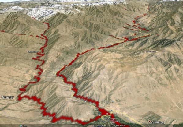
5 Example GSSHA Model: Helmand River Basin Details: Drainage Area ~ 50,000 km2 Snowmelt driven spring floods Operational flow forecast used to answer several Military RFI s. Hydrometeorological (HMET) data from Global Climate Models. Observed snow cover area (SCA) from satellites and limited flow data available. BUILDING STRONG
 Temperature Index (TI) (SNOW-17; Anderson 2006) Flow Processes Vertical")

6 Cold Region Hydrology (GSSHA) Snow Simulation Energy Balance (EB) (Downer et al., 2004) Temperature Index (TI) (SNOW-17; Anderson 2006) Flow Processes Vertical percolation through the snowpack Lateral flow through the snowpack Frozen Ground Geophysical Institute Permafrost Lab Physics based approach Continuous Frozen Ground Index Empirical approach
7 Snow is Spatially Heterogeneous Snow Heterogeneity Air Temperature (function of elevation; lapse rate) Topography (Blöschl et al., 1991; Kirnbauer et al., 1994) Cloud Cover (Aguado, 1985; Sicart et al., 2006) Vegetation (Jost et al., 2007) Energy Balance (Downer et al., 2004) Robust and can capture spatial heterogeneity Require high-quality spatiotemporal forcing data (e.g. temperature, pressure, relative humidity, shortwave radiation, etc.) (Franz et al., 2008). Temperature Index (SNOW-17; Anderson 2006) Widely used due to limited data requirements and tunable parameters. High number of parameters and accounts for spatial heterogeneity based only on elevation-temperature relationship.
8 Radiation-Derived Temperature Index (RTI) Model Start with commonly used SNOW-17 model; Melt=M f *T a Replace T a with a better representation of the energy available to melt the snowpack. We call this variable T rad Estimate T rad with a simple radiation balance: T rad = f(sw and LW ) Reduces number of calibration parameters Requires cloud cover data (from satellites or most airports) Accounts for topography, vegetation, cloud cover, and snow albedo SW = f(cloud cover, topography, vegetation, lat/long) LW = f(air temperature, cloud cover, vegetation) 8


9 Test Site: Senator Beck Basin, CO Highlights: Showed accurate snow simulation in an Alpine terrain (Follum et al., 2015) RTI model more accurate than TI and EB models


10 Test Site: Senator Beck Basin, CO 10


11 Test Site: Hubbard Brook, NH
 Contributes to most of the severe flooding and erosion events in the Pacific Northwest (Johnson & McArthur 1973) Increased erosion (Seyfried & Flerchinger 1994) and")
12 Future Work: Frozen Ground Why do we care about Frozen Ground: It s effect at the watershed-scale is still not very well understood Flooding (e.g. Red River of the North) Contributes to most of the severe flooding and erosion events in the Pacific Northwest (Johnson & McArthur 1973) Increased erosion (Seyfried & Flerchinger 1994) and water quality concerns It s Prevalent; 50% of exposed lands in Northern Hemisphere (Zhang et al., 2003) What influences presence of Frozen Ground: Vegetation (Diebold 1938; Kienholz, 1940; Shanley and Chalmers, 1999) Elevation / T a (Seyfried & Wilcox, 1995) Topography (Flerchinger et al., 1990) Snow Depth (Willis et al., 1961) Soil Moisture (Willis et al., 1961) Spatial Processes GSSHA Frozen Ground Physics-Based Approach Requires snow depth, T a, and soil thermal conductivity. Soil Moisture calculated within the model. Empirical Approach Requires T a and calibration We propose to replace T a with T rad and then test approach against observed data Average depth to which soil freezes in the winter (Davis 2001) 12
13 Conclusions The RTI model appears to outperform both TI and EB models at the few locations tested (Colorado and New Hampshire). The RTI model incorporates topography and vegetation into the simulation, improving SCA estimates. Compared to the TI model, the RTI model has fewer calibration parameters (depending on number of vegetation classes), and only adds cloud cover as a required input. Approach is transferable to other TI models that use a distributed domain. Similar approach may be applicable to Frozen Ground.

14 Questions
Flood Forecasting Tools for Ungauged Streams in Alberta: Status and Lessons from the Flood of 2013
 Flood Forecasting Tools for Ungauged Streams in Alberta: Status and Lessons from the Flood of 2013 John Pomeroy, Xing Fang, Kevin Shook, Tom Brown Centre for Hydrology, University of Saskatchewan, Saskatoon
Land Surface: Snow Emanuel Dutra
 Land Surface: Snow Emanuel Dutra emanuel.dutra@ecmwf.int Slide 1 Parameterizations training course 2015, Land-surface: Snow ECMWF Outline Snow in the climate system, an overview: Observations; Modeling;
Basic Hydrologic Science Course Understanding the Hydrologic Cycle Section Six: Snowpack and Snowmelt Produced by The COMET Program
 Basic Hydrologic Science Course Understanding the Hydrologic Cycle Section Six: Snowpack and Snowmelt Produced by The COMET Program Snow and ice are critical parts of the hydrologic cycle, especially at
Snowcover interaction with climate, topography & vegetation in mountain catchments
 Snowcover interaction with climate, topography & vegetation in mountain catchments DANNY MARKS Northwest Watershed Research Center USDA-Agricultural Agricultural Research Service Boise, Idaho USA RCEW
Effects of forest cover and environmental variables on snow accumulation and melt
 Effects of forest cover and environmental variables on snow accumulation and melt Mariana Dobre, William J. Elliot, Joan Q. Wu, Timothy E. Link, Ina S. Miller Abstract The goal of this study was to assess
Land Surface Processes and Their Impact in Weather Forecasting
 Land Surface Processes and Their Impact in Weather Forecasting Andrea Hahmann NCAR/RAL with thanks to P. Dirmeyer (COLA) and R. Koster (NASA/GSFC) Forecasters Conference Summer 2005 Andrea Hahmann ATEC
Central Asia Regional Flash Flood Guidance System 4-6 October Hydrologic Research Center A Nonprofit, Public-Benefit Corporation
 http://www.hrcwater.org Central Asia Regional Flash Flood Guidance System 4-6 October 2016 Hydrologic Research Center A Nonprofit, Public-Benefit Corporation FFGS Snow Components Snow Accumulation and
Flood Risk Assessment
 Flood Risk Assessment February 14, 2008 Larry Schick Army Corps of Engineers Seattle District Meteorologist General Assessment As promised, La Nina caused an active winter with above to much above normal
Quenching the Valley s thirst: The connection between Sierra Nevada snowpack & regional water supply
 Quenching the Valley s thirst: The connection between Sierra Nevada snowpack & regional water supply Roger Bales, UC Merced Snow conditions Snow & climate change Research directions Sierra Nevada snow
Inter-linkage case study in Pakistan
 7 th GEOSS Asia Pacific Symposium GEOSS AWCI Parallel Session: 26-28 May, 2014, Tokyo, Japan Inter-linkage case study in Pakistan Snow and glaciermelt runoff modeling in Upper Indus Basin of Pakistan Maheswor
How can flux-tower nets improve weather forecast and climate models?
 How can flux-tower nets improve weather forecast and climate models? Alan K. Betts Atmospheric Research, Pittsford, VT akbetts@aol.com Co-investigators BERMS Data: Alan Barr, Andy Black, Harry McCaughey
Modeling the Arctic Climate System
 Modeling the Arctic Climate System General model types Single-column models: Processes in a single column Land Surface Models (LSMs): Interactions between the land surface, atmosphere and underlying surface
Canadian Prairie Snow Cover Variability
 Canadian Prairie Snow Cover Variability Chris Derksen, Ross Brown, Murray MacKay, Anne Walker Climate Research Division Environment Canada Ongoing Activities: Snow Cover Variability and Links to Atmospheric
A Method for Prompt Streamflow and Flood Inundation Estimation Over Large Extents at a High Spatial Resolution
 A Method for Prompt Streamflow and Flood Inundation Estimation Over Large Extents at a High Spatial Resolution Michael L. Follum, Alan D. Snow, Ahmad A. Tavakoly, and Mark D. Wahl USACE-ERDC-CHL Vicksburg,
IP3 Workshop #3, November 2008, Whitehorse, Yukon
 River and Lake Ice: Quantification, Extremes and Historical i Trends; Advances under IPY cryosphere/hydrology & ArcticNet Terry Prowse Katrina Bennett Rheannon Brooks Laurent de Rham Holly Goulding Simon
Assessment of extreme flood characteristics based on a dynamic-stochastic model of runoff generation and the probable maximum discharge
 Risk in Water Resources Management (Proceedings of Symposium H3 held during IUGG211 in Melbourne, Australia, July 211) (IAHS Publ. 347, 211). 29 Assessment of extreme flood characteristics based on a dynamic-stochastic
Climate change projections for Ontario: an updated synthesis for policymakers and planners
 Ministry of Natural Resources and Forestry Climate change projections for Ontario: an updated synthesis for policymakers and planners Shannon Fera and Adam Hogg Ontario Ministry of Natural Resources and
Exploration of California High Resolution Snowpack Modeling with Realistic Surface-Atmospheric Radiation Physics
 Exploration of California High Resolution Snowpack Modeling with Realistic Surface-Atmospheric Radiation Physics Chaincy Kuo, Alan Rhoades, Daniel Feldman Lawrence Berkeley National Laboratory AMS 15th
Using MODIS imagery to validate the spatial representation of snow cover extent obtained from SWAT in a data-scarce Chilean Andean watershed
 Using MODIS imagery to validate the spatial representation of snow cover extent obtained from SWAT in a data-scarce Chilean Andean watershed Alejandra Stehr 1, Oscar Link 2, Mauricio Aguayo 1 1 Centro
Bill Kappel. Doug Hultstrand. Applied Weather Associates
 Cool-Season PMP/PMF Meteorological Time Series for Snow Melt Calculations Bill Kappel Senior Meteorologist/Vice President Doug Hultstrand Hydrometeorologist Applied Weather Associates www.appliedweatherassociates.com
Lake Tahoe Watershed Model. Lessons Learned through the Model Development Process
 Lake Tahoe Watershed Model Lessons Learned through the Model Development Process Presentation Outline Discussion of Project Objectives Model Configuration/Special Considerations Data and Research Integration
Atmospheric Moisture, Precipitation, and Weather Systems
 Atmospheric Moisture, Precipitation, and Weather Systems 6 Chapter Overview The atmosphere is a complex system, sometimes described as chaotic in nature. In this chapter we examine one of the principal
Evaluation of a MODIS Triangle-based Algorithm for Improving ET Estimates in the Northern Sierra Nevada Mountain Range
 Evaluation of a MODIS Triangle-based Algorithm for Improving ET Estimates in the Northern Sierra Nevada Mountain Range Kyle R. Knipper 1, Alicia M. Kinoshita 2, and Terri S. Hogue 1 January 5 th, 2015
UGRC 144 Science and Technology in Our Lives/Geohazards
 UGRC 144 Science and Technology in Our Lives/Geohazards Flood and Flood Hazards Dr. Patrick Asamoah Sakyi Department of Earth Science, UG, Legon College of Education School of Continuing and Distance Education
Modelling snow water equivalent and depth in Watershed Simulation and Forecasting System at SYKE
 Modelling snow water equivalent and depth in Watershed Simulation and Forecasting System at SYKE Vesa Kolhinen Finnish Environment Institute Pyry-seminar 2.11.2015 WSFS Watershed Simulation and Forecasting
Zachary Holden - US Forest Service Region 1, Missoula MT Alan Swanson University of Montana Dept. of Geography David Affleck University of Montana
 Progress modeling topographic variation in temperature and moisture for inland Northwest forest management Zachary Holden - US Forest Service Region 1, Missoula MT Alan Swanson University of Montana Dept.
SMAP and SMOS Integrated Soil Moisture Validation. T. J. Jackson USDA ARS
 SMAP and SMOS Integrated Soil Moisture Validation T. J. Jackson USDA ARS Perspective Linkage of SMOS and SMAP soil moisture calibration and validation will have short and long term benefits for both missions.
NIDIS Intermountain West Drought Early Warning System February 12, 2019
 NIDIS Intermountain West Drought Early Warning System February 12, 2019 Precipitation The images above use daily precipitation statistics from NWS COOP, CoCoRaHS, and CoAgMet stations. From top to bottom,
Daytime long-wave radiation approximation for physical hydrological modelling of snowmelt: a case study of southwestern Ontario
 Soil-Vegetation-Atmosphere Transfer Schemes and Large-Scale Hydrological Models (Proceedings of a symposium held during tile Sixth I AI IS Scientific Assembly at Maastricht, The Netherlands. July 2001).
Direction and range of change expected in the future
 Direction and range of Air Temperature Over the past 30 years, air Across the greater PNW and temperature has been Columbia Basin, an ensemble increasing an average of forecast from ten of the best 0.13
Snow, Snowpacks and Runoff. David G Tarboton Charles H Luce
 Snow, Snowpacks and Runoff David G Tarboton Charles H Luce Show and Tell Images from http://www.anri.barc.usda.gov/emusnow/default.htm Potential effects of climate change on snow Advance in snowmelt timing
Water Balance in the Murray-Darling Basin and the recent drought as modelled with WRF
 18 th World IMACS / MODSIM Congress, Cairns, Australia 13-17 July 2009 http://mssanz.org.au/modsim09 Water Balance in the Murray-Darling Basin and the recent drought as modelled with WRF Evans, J.P. Climate
Operational Perspectives on Hydrologic Model Data Assimilation
 Operational Perspectives on Hydrologic Model Data Assimilation Rob Hartman Hydrologist in Charge NOAA / National Weather Service California-Nevada River Forecast Center Sacramento, CA USA Outline Operational
Terrestrial Snow Cover: Properties, Trends, and Feedbacks. Chris Derksen Climate Research Division, ECCC
 Terrestrial Snow Cover: Properties, Trends, and Feedbacks Chris Derksen Climate Research Division, ECCC Outline Three Snow Lectures: 1. Why you should care about snow: Snow and the cryosphere Classes of
NIDIS Intermountain West Regional Drought Early Warning System February 7, 2017
 NIDIS Drought and Water Assessment NIDIS Intermountain West Regional Drought Early Warning System February 7, 2017 Precipitation The images above use daily precipitation statistics from NWS COOP, CoCoRaHS,
Appendix A Calibration Memos
 Appendix A Calibration Memos University of Washington Department of Civil and Environmental Engineering TO: Joe Dvorak FROM: Margaret Hahn and Richard Palmer RE: DVSVM Calibration DATE: June 28, 21 This
By Charis Smith, Cassie Scruggs, Erol Chandler, & Shawna Fox Anderson
 By Charis Smith, Cassie Scruggs, Erol Chandler, & Shawna Fox Anderson What are the different types of ice? How was the ice identified? What can we draw from comparing Mars ice with the ice seen here on
 Permafrost http://www.cbc.ca/news/canada/story/2011/11/16/north-bigfix-permafrost.html 1. What is permafrost? Permafrost is a thick layer of permanently frozen ground. 2. Large parts of northeastern Russia
Forecast Challenges for the Colorado Basin River Forecast Center
 Forecast Challenges for the Colorado Basin River Forecast Center John Lhotak, Development and Operations Hydrologist Improving Sub-Seasonal to Seasonal (S2S) Workshop May 16th, 2018 1 River Forecast Centers
The role of soil moisture in influencing climate and terrestrial ecosystem processes
 1of 18 The role of soil moisture in influencing climate and terrestrial ecosystem processes Vivek Arora Canadian Centre for Climate Modelling and Analysis Meteorological Service of Canada Outline 2of 18
5. General Circulation Models
 5. General Circulation Models I. 3-D Climate Models (General Circulation Models) To include the full three-dimensional aspect of climate, including the calculation of the dynamical transports, requires
Jennifer Jacobs, Bryan Carignan, and Carrie Vuyovich. Environmental Research Group University of New Hampshire
 Jennifer Jacobs, Bryan Carignan, and Carrie Vuyovich Environmental Research Group University of New Hampshire New Hampshire Water Conference March 21, 2014 Funding Provided By: NASA 1 Precipitation is
The Documentation of Extreme Hydrometeorlogical Events: Two Case Studies in Utah, Water Year 2005
 The Documentation of Extreme Hydrometeorlogical Events: Two Case Studies in Utah, Water Year 2005 Tim Bardsley1*, Mark Losleben2, Randy Julander1 1. USDA, NRCS, Snow Survey Program, Salt Lake City, Utah.
Missouri River Basin Water Management Monthly Update
 Missouri River Basin Water Management Monthly Update Participating Agencies 255 255 255 237 237 237 0 0 0 217 217 217 163 163 163 200 200 200 131 132 122 239 65 53 80 119 27 National Oceanic and Atmospheric
Satellite Observations and Climate Modeling: What They Can and Cannot Reveal About Future Climate
 Satellite Observations and Climate Modeling: What They Can and Cannot Reveal About Future Climate INCOSE Chesapeake Chapter JHU/APL March 21, 2012 Albert Arking Dept of Earth and Planetary Sciences Johns
Assimilation of satellite derived soil moisture for weather forecasting
 Assimilation of satellite derived soil moisture for weather forecasting www.cawcr.gov.au Imtiaz Dharssi and Peter Steinle February 2011 SMOS/SMAP workshop, Monash University Summary In preparation of the
ATMOSPHERIC CIRCULATION AND WIND
 ATMOSPHERIC CIRCULATION AND WIND The source of water for precipitation is the moisture laden air masses that circulate through the atmosphere. Atmospheric circulation is affected by the location on the
A SURVEY OF HYDROCLIMATE, FLOODING, AND RUNOFF IN THE RED RIVER BASIN PRIOR TO 1870
 A SURVEY OF HYDROCLIMATE, FLOODING, AND RUNOFF IN THE RED RIVER BASIN PRIOR TO 1870 W. F. RANNIE (UNIVERSITY OF WINNIPEG) Prepared for the Geological Survey of Canada September, 1998 TABLE OF CONTENTS
INTRODUCTION TO HEC-HMS
 INTRODUCTION TO HEC-HMS Hydrologic Engineering Center- Hydrologic Modeling System US Army Corps of Engineers Hydrologic Engineering Center HEC-HMS Uses Schematics Enter properties: watershed, rivers (reaches),
Coupling Climate to Clouds, Precipitation and Snow
 Coupling Climate to Clouds, Precipitation and Snow Alan K. Betts akbetts@aol.com http://alanbetts.com Co-authors: Ray Desjardins, Devon Worth Agriculture and Agri-Food Canada Shusen Wang and Junhua Li
Operational Hydrologic Ensemble Forecasting. Rob Hartman Hydrologist in Charge NWS / California-Nevada River Forecast Center
 Operational Hydrologic Ensemble Forecasting Rob Hartman Hydrologist in Charge NWS / California-Nevada River Forecast Center Mission of NWS Hydrologic Services Program Provide river and flood forecasts
Novel Snotel Data Uses: Detecting Change in Snowpack Development Controls, and Remote Basin Snow Depth Modeling
 Novel Snotel Data Uses: Detecting Change in Snowpack Development Controls, and Remote Basin Snow Depth Modeling OVERVIEW Mark Losleben and Tyler Erickson INSTAAR, University of Colorado Mountain Research
SPATIALLY DISTRIBUTED SNOWMELT INPUTS TO A SEMI-ARID MOUNTAIN WATERSHED
 SPATIALLY DISTRIBUTED SNOWMELT INPUTS TO A SEMI-ARID MOUNTAIN WATERSHED ABSTRACT Charles H. Luce 1, David G. Tarboton 2, Keith R. Cooley 3 Spatial variability in snow accumulation and melt due to topographic
Impacts of snowpack accumulation and summer weather on alpine glacier hydrology
 Impacts of snowpack accumulation and summer weather on alpine glacier hydrology Caroline Aubry-Wake, Dhiraj Pradhananga, John W. Pomeroy GEWEX 8 th Open Science Meeting, Canmore AB, May 3-11 2018 Canadian
CH. 3: Climate and Vegetation
 CH. 3: Climate and Vegetation GROUP WORK RUBRIC Score of 50 (5): Superior - 100% A 5 is superior work, and has completed all requirements of the assignments, it is in order and its presentation is almost
Persistence of Soil Moisture in the Cariboo Mountains, BC
 Persistence of Soil Moisture in the Cariboo Mountains, BC Tullia Leona Upton University of Northern Brithish Columbia M.Sc. Candidate Natural Resources and Environmental Studies upton@unbc.ca Overview
Why modelling? Glacier mass balance modelling
 Why modelling? Glacier mass balance modelling GEO 4420 Glaciology 12.10.2006 Thomas V. Schuler t.v.schuler@geo.uio.no global mean temperature Background Glaciers have retreated world-wide during the last
The elevations on the interior plateau generally vary between 300 and 650 meters with
 11 2. HYDROLOGICAL SETTING 2.1 Physical Features and Relief Labrador is bounded in the east by the Labrador Sea (Atlantic Ocean), in the west by the watershed divide, and in the south, for the most part,
Texas A & M University and U.S. Bureau of Reclamation Hydrologic Modeling Inventory Model description Form. September 2008
 Texas A & M University and U.S. Bureau of Reclamation Hydrologic Modeling Inventory Model description Form September 2008 Name of Model: National Weather Service River Forecast System (NWSRFS) Model Type:
Precipitation, Soil Moisture, Snow, and Flash Flood Guidance Components
 Precipitation, Soil Moisture, Snow, and Flash Flood Guidance Components HYDROLOGIC RESEARCH CENTER 6 May 2015 Flash Flood Basin Delineation GIS processing of digital elevation data to delineate small flash
ASO in Colorado: supporting resilient water management through research support & emerging partnerships
 ASO in Colorado: supporting resilient water management through research support & emerging partnerships Jeffrey S. Deems Airborne Snow Observatory Western Water Assessment National Snow and Ice Data Center
The National Integrated Drought Information System (NIDIS) Moving the Nation from Reactive to Proactive Drought Risk Management
 Moving the Nation from Reactive to Proactive Drought Risk Management") The National Integrated Drought Information System (NIDIS) Moving the Nation from Reactive to Proactive Drought Risk Management CSG-West Annual Meeting Agriculture & Water Committee Snowbird, UT September
The National Integrated Drought Information System (NIDIS) Moving the Nation from Reactive to Proactive Drought Risk Management CSG-West Annual Meeting Agriculture & Water Committee Snowbird, UT September
Preliminary Runoff Outlook February 2018
 Preliminary Runoff Outlook February 2018 Prepared by: Flow Forecasting & Operations Planning Water Security Agency General Overview The Water Security Agency (WSA) is preparing for 2018 spring runoff including
The Use of Inductive and Deductive Reasoning to Model Snowmelt Runoff from Northern Mountain Catchments
 International Congress on Environmental Modelling and Software Brigham Young University BYU ScholarsArchive 3rd International Congress on Environmental Modelling and Software - Burlington, Vermont, USA
Use of Snow Data from Remote Sensing in Operational Streamflow Prediction
 Use of Snow Data from Remote Sensing in Operational Streamflow Prediction Stacie Bender 1, Thomas H. Painter 2, Paul Miller 1, Michelle Stokes 1 1 NOAA/National Wear Service Colorado Basin River Forecast
Monthly Long Range Weather Commentary Issued: APRIL 18, 2017 Steven A. Root, CCM, Chief Analytics Officer, Sr. VP,
 Monthly Long Range Weather Commentary Issued: APRIL 18, 2017 Steven A. Root, CCM, Chief Analytics Officer, Sr. VP, sroot@weatherbank.com MARCH 2017 Climate Highlights The Month in Review The average contiguous
REMOTE SENSING OF PERMAFROST IN NORTHERN ENVIRONMENTS
 REMOTE SENSING OF PERMAFROST IN NORTHERN ENVIRONMENTS What is permafrost? What can we monitor with satellite data? Permafrost is an Essential Climate Variable About 25 % of the land surface is underlain
Midwest and Great Plains Climate- Drought Outlook 17 April 2014
 Midwest and Great Plains Climate- Drought Outlook 17 April 2014 Dr. Dennis Todey State Climatologist South Dakota State Univ. dennis.todey@sdstate.edu 605-688-5141 Photo taken Feb 19, 2013 Tornado-Trenton,
Hydrologic Forecast Centre Manitoba Infrastructure, Winnipeg, Manitoba. FEBRUARY OUTLOOK REPORT FOR MANITOBA February 23, 2018
 Page 1 of 17 Hydrologic Forecast Centre Manitoba Infrastructure, Winnipeg, Manitoba FEBRUARY OUTLOOK REPORT FOR MANITOBA February 23, 2018 Overview The February Outlook Report prepared by the Hydrologic
Lecture 8: Snow Hydrology
 GEOG415 Lecture 8: Snow Hydrology 8-1 Snow as water resource Snowfall on the mountain ranges is an important source of water in rivers. monthly pcp (mm) 100 50 0 Calgary L. Louise 1 2 3 4 5 6 7 8 9 10
Atmospheric Processes
 Atmospheric Processes Atmospheric prognostic variables Wind Temperature Humidity Cloud Water/Ice Atmospheric processes Mixing Radiation Condensation/ Evaporation Precipitation Surface exchanges Friction
Appendix D. Model Setup, Calibration, and Validation
 . Model Setup, Calibration, and Validation Lower Grand River Watershed TMDL January 1 1. Model Selection and Setup The Loading Simulation Program in C++ (LSPC) was selected to address the modeling needs
Modelling runoff from large glacierized basins in the Karakoram Himalaya using remote sensing of the transient snowline
 Remote Sensing and Hydrology 2000 (Proceedings of a symposium held at Santa Fe, New Mexico, USA, April 2000). IAHS Publ. no. 267, 2001. 99 Modelling runoff from large glacierized basins in the Karakoram
Lithosphere: (Rocky Sphere) Solid, rocky, outer layer of the Earth. Includes the crust and part of the upper mantle. Lithosphere
 Solid, rocky, outer layer of the Earth. Includes the crust and part of the upper mantle. Lithosphere") Lithosphere: (Rocky Sphere) Solid, rocky, outer layer of the Earth. Includes the crust and part of the upper mantle. Lithosphere Permafrost Permafrost Ground that is at a temperature of 0 or below for
Lithosphere: (Rocky Sphere) Solid, rocky, outer layer of the Earth. Includes the crust and part of the upper mantle. Lithosphere Permafrost Permafrost Ground that is at a temperature of 0 or below for
ESTIMATING SNOWMELT CONTRIBUTION FROM THE GANGOTRI GLACIER CATCHMENT INTO THE BHAGIRATHI RIVER, INDIA ABSTRACT INTRODUCTION
 ESTIMATING SNOWMELT CONTRIBUTION FROM THE GANGOTRI GLACIER CATCHMENT INTO THE BHAGIRATHI RIVER, INDIA Rodney M. Chai 1, Leigh A. Stearns 2, C. J. van der Veen 1 ABSTRACT The Bhagirathi River emerges from
NIDIS Intermountain West Drought Early Warning System January 15, 2019
 NIDIS Drought and Water Assessment NIDIS Intermountain West Drought Early Warning System January 15, 2019 Precipitation The images above use daily precipitation statistics from NWS COOP, CoCoRaHS, and
Presented by Jerry A. Gomez, P.E. National Hydropower Association Northeast Regional Meeting - September 17, 2009
 Presented by Jerry A. Gomez, P.E. National Hydropower Association Northeast Regional Meeting - September 17, 2009 Defining Probable Maximum Precipitation (PMP) PMP is the theoretically greatest depth of
Water cycle changes during the past 50 years over the Tibetan Plateau: review and synthesis
 130 Cold Region Hydrology in a Changing Climate (Proceedings of symposium H02 held during IUGG2011 in Melbourne, Australia, July 2011) (IAHS Publ. 346, 2011). Water cycle changes during the past 50 years
Christopher L. Castro Department of Atmospheric Sciences University of Arizona
 Spatiotemporal Variability and Covariability of Temperature, Precipitation, Soil Moisture, and Vegetation in North America for Regional Climate Model Applications Christopher L. Castro Department of Atmospheric
The in uence of the spatial distribution of snow on basin-averaged snowmelt
 Hydrological Processes Hydrol. Process. 12, 1671±1683 (1998) The in uence of the spatial distribution of snow on basin-averaged snowmelt Charles H. Luce, 1 * David G. Tarboton 2 and Keith R. Cooley 3 1
CW3E Atmospheric River Update
 CW3E Atmospheric River Update Update on Late Season AR Forecast to Impact West Coast Later This Week - Little change from yesterday s forecast - Ensemble GFS members are still in good agreement of the
Understanding land-surfaceatmosphere. observations and models
 Understanding land-surfaceatmosphere coupling in observations and models Alan K. Betts Atmospheric Research akbetts@aol.com MERRA Workshop AMS Conference, Phoenix January 11, 2009 Land-surface-atmosphere
Snow Data Assimilation
 Snow Data Assimilation Andrew G. Slater 1 and Martyn P. Clark 2 1 National Snow & Ice Data Centre (NSIDC), University of Colorado 2 National Institute of Water and Atmospheric Research (NIWA), New Zealand
Water, geology, climate & soils: Sierra Nevada, Merced River & Central Valley connections
 Water, geology, climate & soils: Sierra Nevada, Merced River & Central Valley connections Geography & geology Merced River basin Climate & hydrology Soils & soil formation Roger Bales UC Merced Water,
EVALUATION AND MONITORING OF SNOWCOVER WATER RESOURCES IN CARPATHIAN BASINS USING GEOGRAPHIC INFORMATION AND SATELLITE DATA
 EVALUATION AND MONITORING OF SNOWCOVER WATER RESOURCES IN CARPATHIAN BASINS USING GEOGRAPHIC INFORMATION AND SATELLITE DATA Gheorghe Stancalie, Simona Catana, Anisoara Iordache National Institute of Meteorology
NIDIS Intermountain West Drought Early Warning System May 23, 2017
 NIDIS Drought and Water Assessment NIDIS Intermountain West Drought Early Warning System May 23, 2017 Precipitation The images above use daily precipitation statistics from NWS COOP, CoCoRaHS, and CoAgMet
Advancing Remote-Sensing Methods for Monitoring Geophysical Parameters
 Advancing Remote-Sensing Methods for Monitoring Geophysical Parameters Christian Mätzler (Retired from University of Bern) Now consultant for Gamma Remote Sensing, Switzerland matzler@iap.unibe.ch TERENO
Environment Canada Modelling Systems and the 2013 Alberta Floods
 Environment Canada Modelling Systems and the 2013 Alberta Floods Calgary, Alberta February 19, 2014 Bruce Davison (EC) Al Pietroniro (EC) Nick Kouwen (UW) Anthony Liu (EC) Muluneh Mekonnen (AB) Ron Goodison
Snow Melt with the Land Climate Boundary Condition
 Snow Melt with the Land Climate Boundary Condition GEO-SLOPE International Ltd. www.geo-slope.com 1200, 700-6th Ave SW, Calgary, AB, Canada T2P 0T8 Main: +1 403 269 2002 Fax: +1 888 463 2239 Introduction
Evaluation of the ERA-40 Surface Water Budget and Surface Temperature for the Mackenzie River Basin
 1194 JOURNAL OF HYDROMETEOROLOGY VOLUME 4 Evaluation of the ERA-40 Surface Water Budget and Surface Temperature for the Mackenzie River Basin ALAN K. BETTS AND JOHN H. BALL Atmospheric Research, Pittsford,
Snow II: Snowmelt and energy balance
 Snow II: Snowmelt and energy balance The are three basic snowmelt phases 1) Warming phase: Absorbed energy raises the average snowpack temperature to a point at which the snowpack is isothermal (no vertical
The Hydrologic Cycle: How Do River Forecast Centers Measure the Parts?
 The Hydrologic Cycle: How Do River Forecast Centers Measure the Parts? Greg Story Meteorologist National Weather Service Fort Worth, TX Overview n Introduction What is the mission of an RFC? n The Hydrologic
Surface Hydrology Research Group Università degli Studi di Cagliari
 Surface Hydrology Research Group Università degli Studi di Cagliari Evaluation of Input Uncertainty in Nested Flood Forecasts: Coupling a Multifractal Precipitation Downscaling Model and a Fully-Distributed
Monthly Long Range Weather Commentary Issued: APRIL 1, 2015 Steven A. Root, CCM, President/CEO
 Monthly Long Range Weather Commentary Issued: APRIL 1, 2015 Steven A. Root, CCM, President/CEO sroot@weatherbank.com FEBRUARY 2015 Climate Highlights The Month in Review The February contiguous U.S. temperature
NIDIS Intermountain West Drought Early Warning System March 26, 2019
 NIDIS Intermountain West Drought Early Warning System March 26, 2019 The images above use daily precipitation statistics from NWS COOP, CoCoRaHS, and CoAgMet stations. From top to bottom, and left to right:
Chapter outline. Reference 12/13/2016
 Chapter 2. observation CC EST 5103 Climate Change Science Rezaul Karim Environmental Science & Technology Jessore University of science & Technology Chapter outline Temperature in the instrumental record
Investigation IV: Seasonal Precipitation and Seasonal Surface Runoff in the US
 Investigation IV: Seasonal Precipitation and Seasonal Surface Runoff in the US Purpose Students will consider the seasonality of precipitation and surface runoff and think about how the time of year can
P. Marsh and J. Pomeroy National Hydrology Research Institute 11 Innovation Blvd., Saskatoon, Sask. S7N 3H5
 WATER AND ENERGY FLUXES DURING THE SNOWMELT PERIOD AT AN ARCTIC TREELINE SITE P. Marsh and J. Pomeroy National Hydrology Research Institute 11 Innovation Blvd., Saskatoon, Sask. S7N 3H5 marshp@nhrisv.nhrc.skdoe.ca
Drought Monitoring with Hydrological Modelling
 st Joint EARS/JRC International Drought Workshop, Ljubljana,.-5. September 009 Drought Monitoring with Hydrological Modelling Stefan Niemeyer IES - Institute for Environment and Sustainability Ispra -
The Importance of Snowmelt Runoff Modeling for Sustainable Development and Disaster Prevention
 The Importance of Snowmelt Runoff Modeling for Sustainable Development and Disaster Prevention Muzafar Malikov Space Research Centre Academy of Sciences Republic of Uzbekistan Water H 2 O Gas - Water Vapor