Celebrate Your Region!
|
|
|
- Anne Carr
- 5 years ago
- Views:
Transcription


1 HANDS-ON SCIENCE ACTIVITIES Activity 7 Celebrate Your Region! For use with participants ages 10 to 13
2 Contents Discover Earth Themes and Overview of Activities... 3 How to Use These Activities in Your Programs... 5 Correlations to National Standards... 6 Activity Procedure... 9 Overview... 9 What s the Point?... 9 Materials Preparation Introduction Conclusion Part A: Climate Post Card Activity Procedure Materials for Part A Preparation for Part A Activity for Part A Part B: Recipe for a Region Activity Procedure Materials for Part B Preparation for Part B Activity for Part B Part C: Changes to Come Activity Procedure Materials for Part C Preparation for Part C Activity for Part C Contact Information STAR_Net Project Overview Online Community Credits and Acknowledgements Appendix: Activity Materials to Print STAR_Net Project
3 Discover Earth Themes and Overview of Activities The Discover Earth activities focus on Earth science topics close to home such as local weather and the plants, animals, crops, and environmental features particular to your region as well as a global view of our changing planet. Through hands-on investigations and discussions, young audiences discover that Earth s global environment changes and is changed by the local environment. The activities explore three key messages relating to this overall theme: A. We belong to Earth; B. Each region is unique; and C. Your home is changing. These messages all relate to the overall theme: Earth s global environment changes and is changed by the local environment. The activities were developed with guidelines set forth by the National Science Education Standards and American Association for the Advancement of Science (AAAS) benchmarks, and they were designed for audiences in the following four age ranges: 5 to 7, 8 to 9, 10 to 13, and teens. Overall Theme Earth s global environment changes and is changed by the local environment. A. We Belong to Earth We belong to a complex system of interacting water, ice, air, and life. Community Activities The community contributes to two exhibits: In Century of Change Display, the community gathers and compares photos and/or illustrations of the local areas taken a century and more ago with more contemporary photos of the same areas. In Weather Wall, children track the local weather over a period of two months or more, plotting weather data on a kid-friendly sticker chart. Icebreaker Activities Children ages 5 and up are introduced to Earth s major characteristics (or parts or systems) -- water, ice, air, and life through the brief icebreaker activities Catch!...the World s Ocean, Ice-y Experience, Share the Air, and Web of Life. Discover Earth through Reading I Belong to Earth can serve either as part of a kick-off celebration or as an outreach program to area schools. Children and teens discover Earth science questions and answers using the library s resources and participate in reading games customized for ages 5 to 9, 10 to 13, and teens that combine book lists and reading logs into take-home adventures! After this activity, the reading 3 STAR_Net Project
4 games continue to connect patrons with the Discover Earth activities and resources. Participants advance by reading, engaging in suggested at-home activities, attending Discover Earth library programs, or investigating Earth and the environment through a variety of citizen science programs. Completed game boards may be submitted to the library for display, and if desired, entry into promotional drawings. Participants earn a decal upon completion. B. Each Region Is Unique Changes to distant oceans, air moving freely around our globe, and all living things have an influence on our regional environment, now and in the past and future. Weather Explorations Children ages 5 to 7 explore various aspects of weather through a series of stations featuring games, crafts, and weather observations in Weather: The Many Faces of Mother Nature. Children ages 8 to 9 and 10 to 13 undertake more advanced investigations of rain, wind, clouds, and weather instruments and consider how locally collected weather data relate to the broader Earth systems of water, ice, air, and life in Weather Stations. Regional Explorations In Climate Tour, children ages 10 to 13 celebrate their region of the United States by creating a regionally-inspired postcard and recipe. Finally, they use a set of What if cards about their region to reconsider their postcards and recipes in light of future climate change. In Polar Bears or Penguins?, children ages 10 to 13 use a fast-action matching game to demonstrate how each of Earth s polar regions is distinct and special. C. Your Home Is Changing Earth s water, ice, air, and life will continue to interact over long-term scales, shaping the particular features of that place we each call home. Environmental Stewardship In teams, children ages 11 to 13 build an understanding of how human actions impact global change by playing a board game, Polar Bears Go with the Floes, in which chance and choice determine the fate of a lone polar bear on an ice floe. Teens, ages 14 to 18, engage their communities in science through art in Earth: Artistically Balanced. The teens first interact with a climate scientist to unravel, on a very basic level, the complexities of Earth s climate system, and then they create a three-dimensional artistic representation of Earth s climate. The art may be created on a large scale and displayed at the library or made on a smaller scale to take home. 4 STAR_Net Project


5 How to Use These Activities in Your Programs You may design your own program of one or more of these flexible activities, or you may choose to build the story of Earth and its changing environment through the complete series of activities! Background information and facilitator resources are provided to help you prepare to lead the activities. Encourage further exploration with the books, websites, and videos listed in the Facilitator s Resources packet. Programming ideas for all ages, infant to adult, are also provided. Reading games, geared toward different age levels, support this module and connect the activities and resources. The games combine the traditional reading log and book list into a board game, where participants advance by reading, engaging in suggested at-home activities, attending library programs, or investigating Earth and the environment through a variety of citizen science programs. These games are introduced in Activity 4: I Belong to Earth. The game boards may be customized with your institutions address, and if desired, an additional step in the instructions for winning prizes. Matching decals may be printed and awarded as prizes. Read Me bookmarks are available as a way for children to read, review, and recommend titles to others. These materials (shown below), including the supporting book lists, are available free for educational use at 5 STAR_Net Project
6 Correlations to National Standards National Science Education Standards Grades 5-8 Life Science - Content Standard C Populations and Ecosystems Populations of organisms can be categorized by the function they serve in an ecosystem. Understanding Regulation and Behavior All organisms must be able to obtain and use resources, grow, reproduce, and maintain stable internal conditions while living in a constantly changing external environment. Understanding Populations and Ecosystems The number of organisms an ecosystem can support depends on the resources available and abiotic factors, such as quantity of light and water, range of temperatures, and soil composition. Given adequate biotic and abiotic resources and no disease or predators, populations (including humans) increase at rapid rates. Lack of resources and other factors, such as predation and climate, limit the growth of populations in specific niches in the ecosystem. Earth and Space Science - Content Standard D Understanding the Structure of the Earth System Water, which covers the majority of the Earth's surface, circulates through the crust, oceans, and atmosphere (and cryosphere) in what is known as the water cycle. Clouds, formed by the condensation of water vapor, affect weather and climate. Global patterns of atmospheric movement influence local weather. Oceans have a major effect on climate, because water in the oceans holds a large amount of heat. Understanding Earth's History The earth processes we see today, including erosion, movement of lithospheric plates, and changes in atmospheric composition, are similar to those that occurred in the past. Earth history is also influenced by occasional catastrophes, such as the impact of an asteroid or comet. Science in Personal and Social Perspectives - Content Standard F Understanding Populations, Resources, and Environments 6 STAR_Net Project
7 Human activities also can induce hazards through resource acquisition, urban growth, land-use decisions, and waste disposal. Such activities can accelerate many natural changes. Natural hazards can present personal and societal challenges because misidentifying the change or incorrectly estimating the rate and scale of change may result in either too little attention and significant human costs or too much cost for unneeded preventive measures. Understanding Risks and Benefits Risk analysis considers the type of hazard and estimates the number of people that might be exposed and the number likely to suffer consequences. The results are used to determine the options for reducing or eliminating risks. Students should understand the risks associated with natural hazards (fires, floods, tornadoes, hurricanes, earthquakes, and volcanic eruptions), with chemical hazards (pollutants in air, water, soil, and food), with biological hazards (pollen, viruses, bacterial, and parasites), social hazards (occupational safety and transportation), and with personal hazards (smoking, dieting, and drinking). Important personal and social decisions are made based on perceptions of benefits and risks. Understanding Science and Technology in Society Science influences society through its knowledge and world view. Scientific knowledge and the procedures used by scientists influence the way many individuals in society think about themselves, others, and the environment. The effect of science on society is neither entirely beneficial nor entirely detrimental. Societal challenges often inspire questions for scientific research, and social priorities often influence research priorities through the availability of funding for research. National Geography Standards Grades K-12 NSS-G.K-12.1 THE WORLD IN SPATIAL TERMS Understand how to use maps and other geographic representations, tools, and technologies to acquire, process, and report information from a spatial perspective. Understand how to use mental maps to organize information about people, places, and environments in a spatial context. Understand how to analyze the spatial organization of people, places, and environments on Earth's surface. 7 STAR_Net Project
8 NSS-G.K-12.2 PLACES AND REGIONS Understand the physical and human characteristics of places. Understand that people create regions to interpret Earth's complexity. Understand how culture and experience influence people's perceptions of places and regions. NSS-G.K-12.3 PHYSICAL SYSTEMS Understand the characteristics and spatial distribution of ecosystems on Earth's surface. NSS-G.K-12.4 HUMAN SYSTEMS Understand the characteristics, distribution, and migration of human populations on Earth's surface. Understand the characteristics, distribution, and complexity of Earth's cultural mosaics. NSS-G.K-12.5 ENVIRONMENT AND SOCIETY Understand how human actions modify the physical environment. Understand how physical systems affect human systems. Understand the changes that occur in the meaning, use, distribution, and importance of resources. NSS-G.K-12.6 THE USES OF GEOGRAPHY Understand how to apply geography to interpret the present and plan for the future. National Standards for the English Language Arts NL-ENG.K-12.1 READING FOR PERSPECTIVE Students read a wide range of print and non-print texts to build an understanding of texts, of themselves, and of the cultures of the United States and the world; to acquire new information; to respond to the needs and demands of society and the workplace; and for personal fulfillment. Among these texts are fiction and nonfiction, classic and contemporary works. NL-ENG.K-12.7 EVALUATING DATA Students conduct research on issues and interests by generating ideas and questions, and by posing problems. They gather, evaluate, and synthesize data from a variety of sources (e.g., print and non-print texts, artifacts, people) to communicate their discoveries in ways that suit their purpose and audience. 8 STAR_Net Project
9 Overview Activity Procedure Children, ages 10 to 13, celebrate their region of the United States and consider the ways in which climate makes it a unique place. In Part A: Climate Postcard, children each create a postcard about a climate-related aspect of their region, such as weather, clothing or gear, or a plant or animal typical of the area. Facilitators have the option of mailing the postcards to another library in a pen pal arrangement. In Part B: Recipe for a Region, teams of children identify a type of food unique to the region and select a recipe that features that ingredient in children s cookbooks. The children discuss their collective efforts as a regional meal that is suited to the climate of the region. Finally, the teams are provided with a set of What if cards about their region, and they reconsider their postcards and recipes in light of future climate change. The children use a regional map and facts from a variety of sources to complete the components of this activity. Allow 1½ hours for this activity if all three parts are conducted in the same session, as written. Ideally, the icebreaker activity Web of Life is conducted immediately preceding this activity. What s the Point? Changes to distant oceans, air moving freely around our globe, and all living things have an influence on our local environment, now and in the past and future. The terms climate and weather cannot be used interchangeably to describe a region s environment. While weather can change in a matter of hours or with the seasons, climate is the typical weather pattern over a long period of time, generally 30 years or more. The United States consists of several regions that have defined characteristics that are influenced by climate. Our local region is influenced by climate. Climate dictates the weather and the varieties of plants and animals that inhabit a region. Climate influences human activities, including what clothing and gear we keep on hand and what crops we are able to grow. Other regions of the United States are unique in their own way and children living there may have experiences that are different from ours. 9 STAR_Net Project
10 The global climate is changing. Some changes are predicted to be negative, such as a loss of species unable to adapt to the warmer climate. Some changes are predicted to be positive, such as longer growing seasons. Other changes may not have clear impacts, such as the replacement of forests with open grasslands following droughts and wildfires. While change is normal, it is not normal that it is happening so fast. The changes are happening faster than during the last 10,000 years. Materials Facility Needs A large area where children can work in groups Optional: cooking facilities and implements for preparing the children s recipes Optional: dining area for sampling regional foods or prepared recipes For Each Child Optional: His/her Discover Earth reading game board 1 pencil or pen For the Facilitator Facilitator s Resources packet (available at /discoverearth), which includes: Background information Be a Science Guide! Resource lists Shopping list Facilitator s Regional Guide Resources for discussing the implications of climate change, such as: KIDS' QUESTIONS ABOUT GLOBAL WARMING cc_kids_questions This National Wildlife Federation Climate Classroom resource provides the answers to children s and teens common questions about global warming. 10 STAR_Net Project
11 Preparation Review the Facilitator s Resources packet and Facilitator's Regional Guide. Review the activity procedures for Parts A, B, and C. Determine the desired length of the program. If possible, conduct Parts A, B, and C in a single session. Otherwise, ensure that the postcards (Part A) and the Recipe Cards (Part B) are available for the children to look at during Part C. Introduction 1. Conduct the icebreaker activity Web of Life to set the stage for deeper explorations and a positive social experience. Briefly highlight the library s resources and remind the children how they can use their participation in today s activity to advance on their Discover Earth games. Children who were not able to attend the activity I Belong to Earth will benefit from this orientation. 2. Find out what children already know about how the local weather and climate influences our daily lives. What shoes are you wearing today? How did you decide what shoes to wear? Answers will vary, but listen for those that relate to the day s weather. What do we measure in order to describe how warm or cold the day is? Temperature. What s another word for rain and snow? Precipitation. What do we measure in order to describe how much precipitation we ve received? How many inches fell during the shower or storm. What other types of weather do we have here? Answers might include sun, wind, rain, snow, or fog. What types of extreme weather do we have here? Answers might include tornadoes, hurricanes, or blizzards. Do we have wildfires here? What kinds of weather conditions increase the risk of wildfires? Hot, dry, windy weather. What would you have worn if it was sunny? Raining? Snowing? Think about what shoes are in your closet. Are most of them sneakers, Crocs, sandals, flip-flops, hiking boots, galoshes? Are there kinds of shoes that you only rarely or never wear? Guide the discussion away from comfort and fashion and toward what is suitable for your local climate. For example, the children in northern regions or higher altitudes may only occasionally have the opportunity to wear warm-weather shoes such as sandals 11 STAR_Net Project
12 and flip-flops. Children in arid regions may not even own galoshes and those in warm, mild climates may not own snow boots. Think about a place that you ve been that s far away. Do you think the people who live there have different types of shoes in their closets than we do? Weather is what helped you decide what to wear today. Climate determines what you re likely to find in your closet. 3. Introduce the children to the idea that they will be using their knowledge of climate to celebrate their region s unique features in this three-part activity. Explain that, for this activity, the following seven regions of the United States are identified: Northwest High Plains Midwest/Ohio Valley New England/Mid-Atlantic Southeast Southern Southwest 4. Conduct Parts A, B, and C. Conclusion Summarize that Earth s systems interact to create the usual temperature and precipitation or climate and make each region special. Weather including wild weather crops, plants, and animals all depend on that climate. Our everyday lives, like what we keep in our closets, can depend on climate as well. Earth s global climate is changing in some ways that are good, but in many harmful ways. Our nation will likely be different in many climate-related ways 100 years from now. What could you do when you go home today and in the future to change the way you and your family use energy? How can you make sure that less fossil fuels are used to produce the food that you and your family eat? Encourage the children to think of ways to reduce energy and support local food production that they are willing to commit to. Provide a few ideas: 12 STAR_Net Project
13 Turning things off when we re not using them, Walking, biking, or taking the bus where it s safe to do so or carpooling instead of asking for a ride, Eating less meat and more vegetables, and Buying foods that are produced in nearby areas rather than in other states and countries. Invite the children to learn more about the science describing climate change and find ways to take action toward environmental stewardship by checking out library resources (see the Facilitator s Resources packet for suggestions). Leave them with a positive message that there is action that they can take to make our world a better place! If possible, build on the children's knowledge by offering them a future Discover Earth activity. Provide them with the date and time of the next activity and encourage them to return. 13 STAR_Net Project
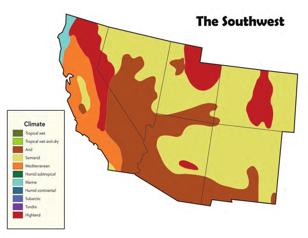
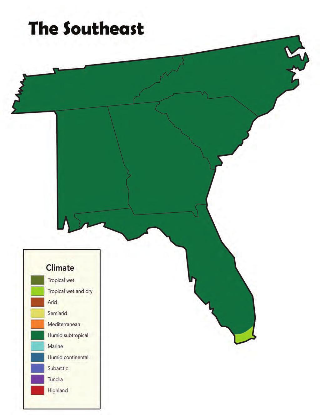
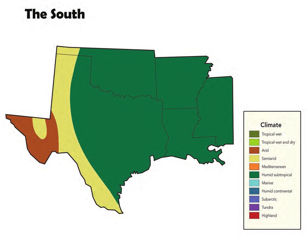
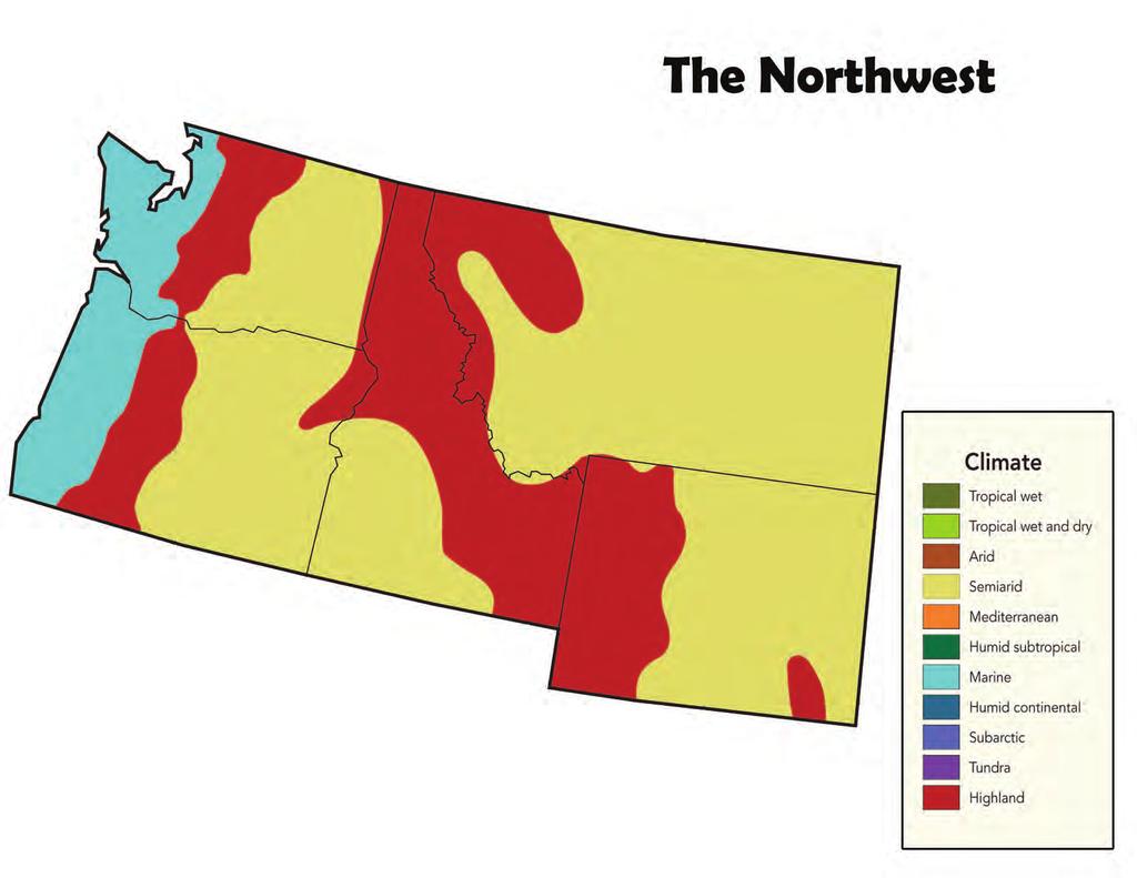
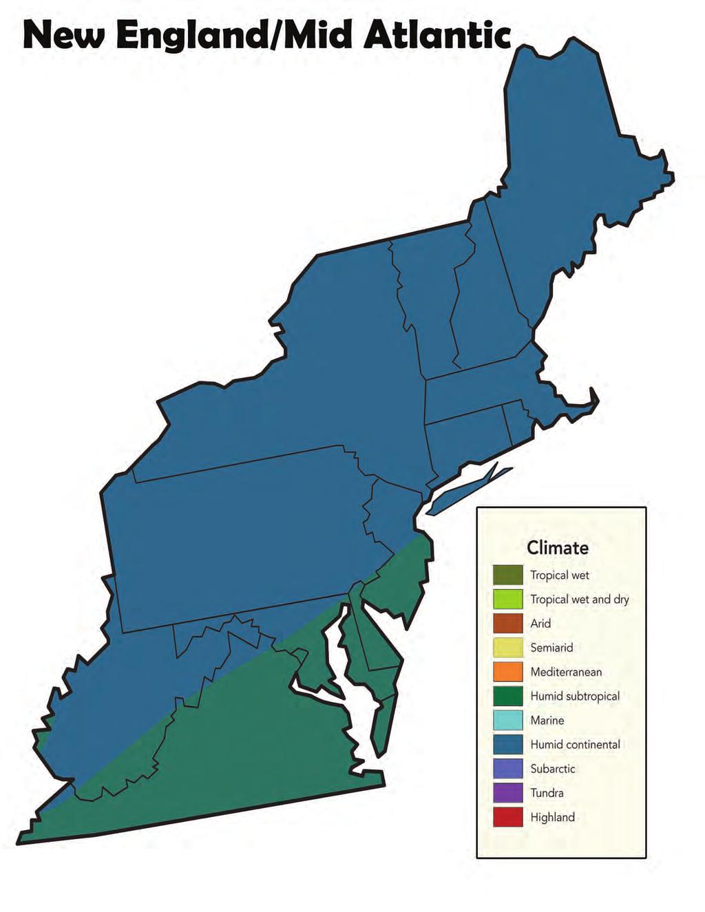
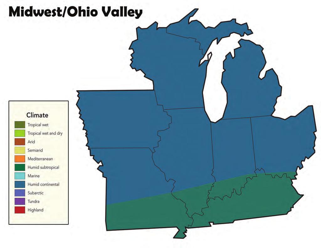
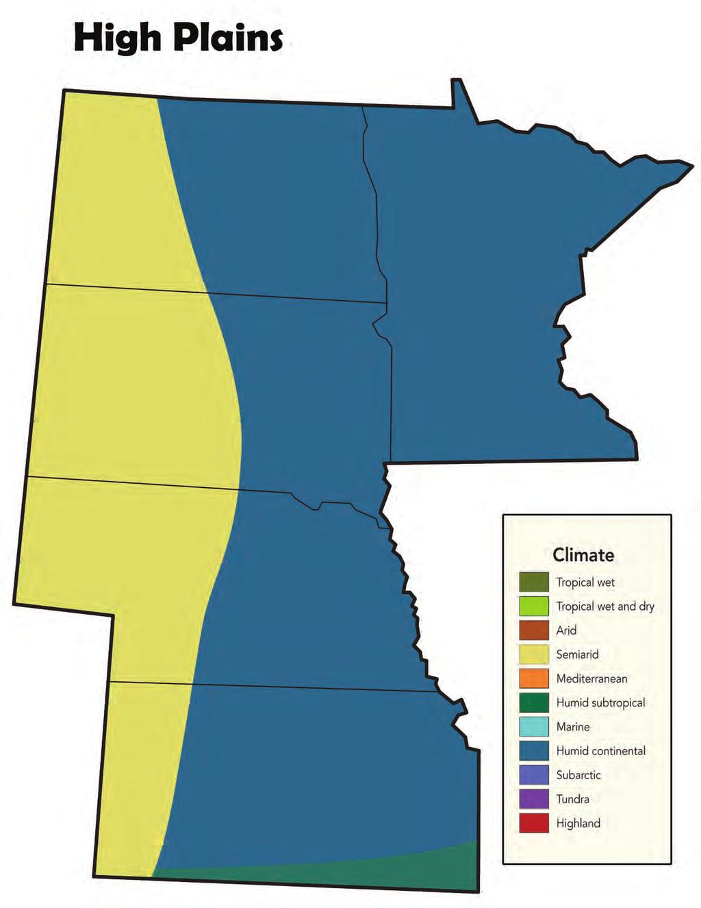
14 Part A: Climate Post Card Activity Procedure Materials for Part A For Each Group of 15 to 30 Children A selection of books and / or access to websites and videos about your region (suggestions are listed in the Facilitator s Resources packet); the sources must describe one or more or the following regional features: - Temperature (summer and winter average high and low) - Annual precipitation - Extreme weather events (e.g., tornados, hurricanes, wildfires) - Crops - Plants and animals and their special adaptations 1 (11 x 14 ) climate map of their region, printed in color: New England/Mid-Atlantic Climate Map Southeast Climate Map South Climate Map Midwest/Ohio Valley Climate Map High Plains Climate Map Southwest Climate Map Northwest Climate Map Art supplies, such as colored pencils, crayons, and markers For Each Child 1 Celebrate Your Region! postcard template (an editable version is available at printed on cardstock or compatible products (such as Avery 3256, 3263, 33380, 3377, 3380, 3381, 5689, 8383, 8387, 8577) 1 postage stamp (visit to determine the postage rate) Preparation for Part A If desired, work with another library in a different region before the program to set up a pen pal relationship. Invite them to conduct this activity and send the 14 STAR_Net Project
15 children s postcards to your institution for display during your program. Upon completion of the program, send the children s postcards in exchange. Facilitator s Note: Join the STAR_Net Project's Community of Practice at and identify a pen pal library through the network there. Print copies of the postcard template for the children. (If you will be sending the postcards to another library, follow this additional step before printing: Type the address of the destination library in the editable field on the editable Microsoft Word template, which can be downloaded from discoverearth.) Cut or tear the cardstock or template into individual postcards. Set out a variety of books, and if desired, provide access to websites and videos about your region. Activity for Part A 5. Explain to the children that they will be depicting how the region s climate shapes one aspect of their lives on a postcard. If the postcards are to be sent to another library, explain what the children can expect from the pen pal relationship and how they will see what other children in distant areas experience. Otherwise, invite the children to think of a family member or friend in another region. 6. Have the children decide which one of the following climate-related aspects of your location they would like to depict: Weather experienced during a typical summer or winter; Wild weather that sometimes occurs (e.g. tornados in Tornado Alley; Nor easters and hurricanes along eastern coastlines; blizzards in northern regions, etc.); Clothing and gear used by the people who live there in summer or winter; Or, wild plants or animals typically found there. 7. Invite the children to read and consider information about their region as they investigate the regional aspect they will depict on each of their postcards. Distribute appropriate library resources about their region, and provide a copy of the region s Climate Map for three to four children to share between themselves. Allow 30 minutes for the children to plan and research. Circulate among the teams and direct them to appropriate library resources, answer questions, and brainstorm ideas. 15 STAR_Net Project
16 8. Distribute the postcards and encourage the children to use their creativity in showcasing their region to the postcards distant recipients! Have them each write and decorate a postcard while leaving the postage and address area clear for mailing purposes. Point out that they will need to note their region s climate zones in the space provided on the postcard. Have them each write the recipient s mailing address and affix a postage stamp. 9. Together, discuss some or all of the weather, clothing, plants, and animals that the children chose to represent your region. After the children have had a chance to share their cards with the group, post them next to the climate map until Parts B and C are completed (or longer). At the end of the sharing period, announce when you will mail the postcards. What climate zones occur in our region? When is the best time to visit? How does the geography influence your region s climate? What plant and wildlife species live in your region? Answers may vary, but may include cactus in the Southwest and alligators in the South. Other examples are listed in the Facilitator s Guide. There are lots of different regions and climate zones across the United States and throughout the world. How might our region be same as and different than those? Accept all answers, but guide the children to consider the special regional features that they are aware of through tourism information, reputation, or in learning about a favorite animal (e.g. the diversity of life in tropical rain forests; warm weather and cool breezes on tropical coastlines; polar bears adapted to hunting on the ice in the Arctic; etc.). Facilitator s Note: Part A of this activity may be expanded with the children researching each region and designing a postcard about it. Compare the different regions to your own to help the children discover what is special about each. Print additional regional Recipe Cards and use them with the postcards to create a display. 16 STAR_Net Project
17 Part B: Recipe for a Region Activity Procedure Materials for Part B For Each Group of 10 to 15 Children A selection of books and / or access to websites and videos about your region s agricultural products, such as those listed in the Facilitator s Resources packet, in addition to children s encyclopedias A selection of cookbooks, such as: BETTY CROCKER KIDS COOK! Heidi Losleben, ed., Betty Crocker, 2007, ISBN: COOKING ROCKS! RACHAEL RAY 30-MINUTE MEALS FOR KIDS Racheal Ray, Lake Isle Press, Inc. 2004, ISBN SALAD PEOPLE AND MORE REAL RECIPES Mollie Katzen, Tricycle Press, 2005, ISBN: COOKING WITH HERB THE VEGETARIAN DRAGON: A COOKBOOK FOR KIDS Jules Bass, Barefoot Books, 1999, ISBN: X THE GOOD HOUSEKEEPING ILLUSTRATED CHILDREN S COOKBOOK Marianne Zanzarella, Morrow Junior Books, 1997, ISBN: THE MITSITAM CAFÉ COOKBOOK Richard Hetzler, Fulcrum Publishing, 2010, ISBN: X While many of these recipes from Smithsonian National Museum of the American Indian are complex, they often feature unique regional ingredients. Children ages 8-13 may find the recipes Fiddlehead Fern Salad, Crabapple and Cranberry Relish, and Cranberry Crumble applicable to this activity. Optional: Regional foods, either in small quantities for tasting or in large quantities for cooking 17 STAR_Net Project
18 For Each Team of Three to Four Children 1 (8 ½ x 11 ) Recipe Card for their region, printed double-sided on card stock: New England/Mid-Atlantic Recipe Card Southeast Recipe Card South Recipe Card Midwest/Ohio Valley Recipe Card High Plains Recipe Card Southwest Recipe Card Northwest Recipe Card Preparation for Part B Set out a variety of books, and if desired, provide access to websites about your region s agricultural products. Set out a selection of cookbooks, including any regional children s cookbooks that are available. If desired, expand Part B to include preparing the children s recipes. Consider identifying a partner to supply regional foods and / or kitchen facilities and implements to use during the program. Perhaps offer a pre-prepared regional dish or snack, or provide a regional snack recipe and the ingredients for the children to prepare themselves during the program. Activity for Part B 10. Set the stage for an Iron Chef-style activity! Explain that, like a complex recipe, many factors influence a region s climate, including latitude, elevation, how close it is to large bodies of water like oceans or lakes, ocean and air currents, and whether there are mountains. The children will work in teams to identify a unique food that grows in your region. Like a secret ingredient in Iron Chef, the teams will focus on this one food as they each search for a kid-friendly recipe that features it. Their recipes must include information about where the food grows and in what conditions it thrives in other words, what about the region s latitude, elevation, relationship to oceans, lakes, mountains, etc. is ideal for that food? 11. Divide the group into teams of three to four, and assign one of the following categories for each team to plan as they work together to design a full meal (or for larger groups, a banquet with multiple dishes in each category): 18 STAR_Net Project
19 Drinks Meat, beans, fish or shellfish, eggs, or nuts; Vegetables Fruits Grains Dessert Facilitator s Note: Eating well-balanced diets contributes to our physical and mental health. According to KidsHealth.org, each day 9 13 year old girls need: 5 ounce equivalents of grain, such as a cup of cereal (boys need 6 ounces); 2 cups of veggies (boys need 2 ½ cups); 1 ½ cups of fruit; 3 cups of milk (or another calcium-rich food); 5 ounce equivalents of meat, beans, fish, and nuts; and 6 to 8 glasses of water. 12. Ask the teams to each identify a regional food ingredient a native, edible plant (wild or cultivated); game, fish, or shellfish; or (non-native) crop that is representative of your region and select a recipe that features that ingredient. (Note that domesticated animals should not be considered as regional food ingredients for this activity, since their dependence on regional characteristics, such as climate, is less apparent.) Distribute a Recipe Card to each team and point out the regional information summarized on one side. Provide cook books as well as books, and if desired, access to websites and videos about your region. Provide them with 30 minutes to find information about their regional food ingredient and to summarize it, along with a recipe, on their team s Recipe Card. 13. Regroup the children and discuss how their recipes, taken together, make a regional meal. What is our average annual precipitation? What high temperatures do we usually have in summer? In winter? What regional food ingredients did you research that are grown here? What about the region s climate allows them to grow there? It s not too hot/cold, or it rains a lot, etc. Could you grow that crop in another region? For example, could you grow wheat in the desert regions of the southwest? Oranges in the northeast? Why not? Not enough rain; too hot or not enough sunny days; too cold. 19 STAR_Net Project
20 Which food ingredients were harvested in the fall? Summer? Spring? All year round? 14. Prepare copies of all of the team s Recipe Cards for each child to take home. Encourage them to use it as a way to incorporate more local foods into their meals. Explain that eating locally is a great way to preserve Earth s resources because local foods require less fuel to transport and so involve the release of less carbon dioxide. In addition, eating locally supports your community s agricultural industries! Facilitator s Note: For institutions with access to cooking facilities, this activity may be expanded to have the children actually prepare the kid-friendly recipes they identify. Consider partnering with a local chef to help facilitate the event. Ensure that there are plenty of adult helpers perhaps parents if the program is open to families and make cooking safety a priority. 15. Optional: Collect copies of the teams Recipe Cards and staple them into a booklet, then mail the booklet to your pen pal library. 20 STAR_Net Project
21 Part C: Changes to Come Activity Procedure Materials for Part C For Each Team of Three to Four Children For each team of three to four children: 1 set of the following What If...Cards for your region, printed double-sided on cardstock and preferably in color: New England/Mid-Atlantic cards Southeast cards South cards Midwest/Ohio Valley cards High Plains cards Southwest cards Northwest cards Preparation for Part C Print out copies of What If...Cards about your region, double-sided on cardstock and preferably in color. Make enough sets for every three to four children to have one. Cut out the cards, keeping each set separate for the different teams to use. Activity for Part C 16. Share that Earth s global climate is changing. The average global temperature has increased about 1 o F in the past 100 years. Scientists predict that the average temperature will continue to rise over the next 100 years, perhaps as much as 3-10 o F. Areas nearer the poles are more sensitive to warming than areas near the equator, and the Arctic is warming about twice as fast compared to the rest of Earth. It is normal for the temperature or precipitation to sometimes be a little different compared to the overall climate (as the children may have discovered while comparing their regions temperature and precipitation data with the overall regional climate). Weather changes all the time! Scientists are concerned because the overall climate is changing. Does weather change? Yes, every day and with the seasons. Does climate change? Yes. 21 STAR_Net Project

22 What was the climate like when the dinosaurs lived? Warm and wet. What was the climate like when saber-toothed tigers and mammoths lived? Many places were colder and drier. Is our climate changing now? Yes, our global climate is changing. Explain that while change is normal, it is not normal that it is happening so fast. The changes are happening faster than during the last 10,000 years. The children may have heard a lot about climate change or global warming in the news and from adults. Reassure them that scientists have been talking about it, too and trying to decide what might be best to do about it. In general, the scientists agree that global climate change is happening and our use of fossil fuels has a lot to do with it. There s a lot we can do about it, too! Use less energy: Turn the lights off when we leave a room, unplug our computers when we are not using them, walk, bike, or take public transportation where it s safe to do so or carpool instead of asking for a ride. Choose foods that take less fossil fuel to produce and transport them: Eat less meat and more vegetables, and buy foods that are produced in nearby areas rather than in other states and countries. We can all make changes every day to help reduce our impact on Earth s global climate! Facilitator s Note: Changes in Earth s orbit, in addition to less influential changes in the Sun s intensity, outgassing from volcanoes and other sources, and changes in ocean currents, have resulted in cycles of cooling and warming. For example, certain eras in the Age of the Dinosaurs were warmer than today, and the ice ages were colder. However, modern human society has never encountered such profound and rapid change. Ancient gases and chemical signatures trapped in ice cores, tree rings, and other data provide evidence that the amount of carbon dioxide in Earth's atmosphere, and Earth's 22 STAR_Net Project
23 temperature, have fluctuated in a cyclical pattern through time. These cycles of cooling and warming are natural, and caused, over the last 750,000 years, primarily by cyclic changes in Earth's orbit. During that time frame we have experienced alternating periods of warmth and periods of glaciations. However, at present, the levels of carbon dioxide in the atmosphere far exceed even the highest levels of the past half-million years. Our global temperature is increasing in response to this added heat-trapping gas. Image courtesy of the UN Intergovernmental Panel on Climate Change (IPCC), Third Assessment Report, Climate Change Have the children discuss, in teams, some of the ways in which your region might be different 100 years from now due to climate change. Divide the children into teams of three to four preferably in the same teams as in Part B and distribute the What if cards for your region. Explain that even the small increases in temperature and precipitation patterns will have big effects on the U.S. regions. Allow the teams ten minutes to read the cards and consider how they would change the postcards they created in Part A and the regional menu they created in Part B. What are some positive changes that might occur as temperature rise? Longer growing season, more warm days to enjoy the outdoors, more summer foods available for caribou calves, etc. What are some changes that may be difficult to judge as helpful or harmful? Grasslands taking over after forest fires, etc. What might be some difficult changes? Heat waves, butterflies and other species running out of places to live, many heavy rains (which can lead to erosion and flooding), etc. Imagine recreating your postcard to feature the same climate-related aspects as in Part A. How do the What if cards change what you would draw and write on your postcard? Which of the changes shown in the What if cards influence how well native food plants; game, fish, or shellfish; or crops survive in your region? Which changes might be negative? Temperatures are too high for some kinds of plants and animals, drought, severe storms occurring more often and possibly damaging crops. Which might be positive? Longer growing seasons, beneficial bugs also thrive. Do you think that your team s regional food ingredient from Part B will still be found here in 100 years? Why or why not? Facilitator s Note: Environmental responses to climate change are complex and interrelated. These cards explore just some of the potential changes and consequences of global warming. 23 STAR_Net Project
24 Contact Information Your questions and comments about the Discover Earth: Hands-on Science Activities are welcome! Explore Program Team Department of Education and Public Outreach The Lunar and Planetary Institute 3600 Bay Area Boulevard Houston, Texas STAR_Net Project Overview The STAR Library Education Network project (STAR_Net for short) is part of a national initiative to support libraries that are already providing informal STEM learning, or want to provide it. The STAR_Net project has a number of components, including: Two traveling exhibits for libraries: Discover Earth: A Century of Change, and Discover Tech: Engineers Make a World of Difference. An Education Program, which includes developing exemplary hands-on activities for libraries, as well as conducting training (both online and in-person) for library staff. An Outreach Program that helps libraries to develop STEM programming and find local partners for collaborations on programming. An online Community of Practice (CoP) ( for librarians (both hosts and non-hosts of the exhibits) and STEM professionals who want to support STEM programming in public libraries. The National Science Foundation (NSF) provided funding the STAR_Net project. STAR_Net is led by the National Center for Interactive Learning (NCIL) at the Space Science Institute. Dr. Paul Dusenbery is the project director. STAR stands for Science- Technology Activities and Resources. In addition to NCIL staff, the project team includes: The American Library Association (ALA), which is managing the exhibit tours and helping to raise awareness among librarians of the many opportunities for providing STEM programming 24 STAR_Net Project
25 The Lunar and Planetary Institute (LPI), which is leading the Education Program component. For some years, LPI has led the Explore program for libraries, which has been at the forefront of developing STEM programming and training for librarians. The National Girls Collaborative Project (NGCP), which is leading the project s Outreach Program. As a project partner, this NSF-funded project is helping libraries across the country partner with a variety of organizations to provide STEM programming. NCIL s Kate Haley Goldman and staff from Evaluation and Research Associates are conducting evaluations of the project s components. The project also includes a research component that explores how public libraries can serve as STEM learning centers in rural, under-served communities. The evaluation and research results will be shared with the informal science education community. The activity described in this packet was developed for libraries to use in support of the Discover Earth traveling exhibit, though it may be implemented independently. Online Community Librarians, scientists, engineers, educators, museum staff, and others are invited to join the STAR_Net online community! The website fosters collaboration among professionals who want to provide or support Science, Technology, Engineering, and Mathematics (STEM) learning experiences in libraries. The STAR_Net project team hopes you find the following activity useful. Please join the online community ( and share your experiences implementing it with your colleagues. For more information about the STAR_Net project, please contact: Lisa Curtis Projects and Exhibits Manager National Center for Interactive Learning at the Space Science Institute Boulder, CO (720) curtis@spacescience.org 25 STAR_Net Project
26 Credits and Acknowledgements This material is based upon work supported by the National Science Foundation under Grant No. DRL Any opinions, findings, and conclusions or recommendations expressed in this material are those of the authors and do not necessarily reflect the views of the National Science Foundation. Development Team (Lunar and Planetary Institute, Houston, TX) Discover Earth: Hands-on Science Activities was developed by the Lunar and Planetary Institute s Explore program team in support of the Discover Earth travelling exhibition by the Space Science Institute s National Center for Interactive Learning ( Module Development and Workshop Implementation Keliann LaConte Dr. Stephanie Shipp Yolanda Ballard Zimmermann Web Development and Graphics John Blackwell Ronna Hurd Resources Linda Chappell Thanks to Andrea Vaughn, coordinator of Central Library Youth Services at Brooklyn (N.Y.) Public Library, and the Public Library Association Virtual Symposium for reading game ideas. Content and Education Review Dr. Gil Compo, Research Scientist, Cooperative Institute for Research in Environmental Sciences, University of Colorado, Boulder, CO Dr. Sara Harris, University of British Columbia, Vancouver, BC Canada Dr. Walt Meier, National Snow and Ice Data Center, University of Colorado, Boulder, CO Beth Barrett, Louisville Public Library, Louisville, CO Dr. Susan Buhr, Cooperative Institute for Research in Environmental Sciences, University of Colorado, Boulder, CO Tiffany Clendenin, Ruby M. Sisson Memorial Library, Pagosa Springs, CO Dr. Paul Dusenbery, National Center for Interactive Learning at the Space Science Institute, Boulder, CO Deborah Morrison, University of Colorado, Boulder, CO Karen Peterson, National Girls Collaborative Project, Lynnwood, WA
27 Field Tests Appreciation is extended to the librarians who field tested the materials in their children s, youth, and teen programs. Justin Barkley, TLL Temple Memorial Library, Diboll, TX Sally Blevins, Bitterroot Public Library, Hamilton, MT Laura Goss, Adams County Library System, Gettysburg, PA Evaluation Team John Baek, National Oceanic and Atmospheric Administration Vicky Ragan Coulon, Evaluation & Research Associates, Lynnwood, WA Ginger Fitzhugh, Evaluation & Research Associates, Lynnwood, WA Kate Haley Goldman, National Center for Interactive Learning at the Space Science Institute 27 STAR_Net Project
28 Appendix: Activity Materials to Print 28 STAR_Net Project
29 Celebrate Your Region! Facilitator s Regional Guide...a cheat sheet to help you guide the children s explorations of U.S. regions

30 Northwest States: Idaho, Montana, Oregon, Washington, and Wyoming Climates: Mild, High Elevation, Dry Average Temperatures: Summer Highs: o F but highly variable throughout the region; as low at 50 o F and as high as 100 o F can be found there Wyoming. Image courtesy of Microsoft Office software. Summer Lows: o F with some areas reaching o F Winter Highs: o F with some areas reaching o F or o F Winter Lows: 0-20 o F with some areas reaching o F or o F Annual Precipitation: 64 or more on the coast and certain inland areas, but drier inland with only 8-16 in much of the region Extreme weather events: In this area where the Great Plains meet mountain ranges, warm, dry Chinook winds occur in the winter and can quickly and with great variability raise the frigid temperatures and melt/evaporate snow. Frequent strong winds occur in Wyoming. Washington is home to the world record for the most snowfall in one season the winter of delivered 1,140 to Mt. Baker. The southeastern corner of Wyoming is vulnerable to tornadoes. Blizzards and wildfires also occur in this region. Crops: Idaho produces potatoes and wheat while Montana contributes flaxseed and garbanzo beans. Oregon is the leading producer of blackberries, hazelnuts, loganberries, black raspberries, prunes and plums, Christmas trees, and dried herbs. Apples, wine grapes, and Christmas trees are grown in Washington. Wyoming is known for raising cattle and sheep, but also grows crops such as sugarbeets. Plants: This region has extensive coniferous forests. In fact, the Pacific Coast is home to a temperate rainforest. Grasslands and scrublands make up the unforested regions. Animals and their special adaptations: Caribou live in the Northwest, where their side hooves help them walk on snow and soft tundra. Bull trout inhabit the cold waters of the region. Gray wolves are adapted to a variety of habitats here, including temperate forests, mountains, and grasslands. Brown pelicans and leatherback sea turtles are found in many coastal regions of the U.S. Novels: Hattie Big Sky by Kirby Larson

31 High Plains States: Kansas, Minnesota, Nebraska, North Dakota, and South Dakota Climates: Dry, Continental Average Temperatures: Summer Highs: Summer Lows: Winter Highs: Winter Lows: Annual Precipitation: o F o F o F in the South Dakota. southern areas and Image courtesy of the National Park Service. decreasing northward to as low as 10 o F 0-20 o F with the southern areas dipping to 20 o F and -10 o F in the north 16-32, but reaching over 40 in southeast Kansas Extreme weather events: The region is prone to tornadoes. Nebraska has frequent winds. Blizzards and wildfires also occur here. Crops: Corn, wheat, soybeans, alfalfa, and pumpkins are grown in Kansas. Corn is an important crop in Nebraska, with a little under half of the total yield going into ethanol production and ultimately added to gasoline. In addition, soybeans, beans, and wheat are grown there. North Dakota farmers are great producers of flaxseed and canola, and most of the U.S. supply of wheat for pasta (durum) is grown there. Honey is also produced there. Minnesota produces corn and soybeans, and uniquely, wild rice (cultivated paddy rice and traditional Native American hand-harvested wild rice). Corn, grains, and sunflower seeds are grown in South Dakota. Plants: Grasslands are the native plants of the majority of this region. The tall-grass prairie of the region, which is distinct from the short-grass prairie of the Great Plains, is made up of big bluestem, Indian grass, and switchgrass. Minnesota is also home to forests. Animals and their special adaptations: Gray wolves are adapted to a variety of habitats here, including temperate forests and grasslands. Novels: The "Little House" books by Laura Ingalls Wilder

32 Midwest/Ohio Valley States: Illinois, Indiana, Iowa, Kentucky, Michigan, Missouri, Ohio, and Wisconsin Climates: Continental Average Temperatures: Summer Highs: Summer Lows: Winter Highs: Winter Lows: Annual Precipitation: o F with temperatures cooling to 70 o F around the Great Lakes and up to 100 o F in a few southern regions Wisconsin. Image courtesy of Microsoft Office software o F and as low as 50 o F in the north o F with the lowest temperatures in the north 0-30 o F 32-64, but Wisconsin and Michigan tend to be drier. Crops: Corn and soybeans are commonly grown in this region. Illinois also contributes pumpkins. The popcorn variety of corn, tomatoes, and mint are specialties of Indiana. In addition to crops, Iowa is the number one producer of hogs and eggs. Missouri contributes cotton and rice. The Great Lakes moderate temperatures by absorbing heat in summer and releasing it in fall; this unique effect permits Michigan to grow apples, grapes, and cherries fruits that are normally grown further south. Ohio is the number one producer of Swiss cheese in the U.S. and also produces a large crop of pumpkins. Wisconsin produces peas, carrots, and cranberries. Extreme weather events: The Gulf of Mexico and Great Lakes influence the weather patterns of this region. The Great Lakes influence on weather is called the lake effect. In the winter, winds from the west pick up moisture from the lakes and deposit heavy snowfall along eastern lakeshores, such as in Michigan and Ohio. Fog occurs along the shorelines. The region is highly prone to tornadoes, especially in Missouri. Blizzards and wildfires also occur here. Plants: Forests once covered much of this region, with grasslands predominating in some areas. Ohio s eastern and southern regions are covered in hardwood forests; red and white oak and walnut are used as logs, lumber, chips, and used to make furniture and paper. Other broadleaf trees abundant in the Midwest include elm, maple, beech, hickory, ash, and birch. Conifers are found here. Animals and their special adaptations: Kirtland's warblers nest in the young jack pine forests of Michigan, dining on insects, blueberries, and pine sap, before migrating to the southeastern coast of the U.S., and finally to the Bahamas. Gray wolves are adapted to a variety of habitats here, including temperate forests and grasslands. Novels: Adventures of Huckleberry Finn by Mark Twain; Chasing Redbird and Walk Two Moons by Sharon Creech

33 New England/Mid- Atlantic States: Connecticut, Delaware, the District of Columbia, Maine, Maryland, Massachusetts, New Hampshire, New York, Pennsylvania, Rhode Island, Vermont, Virginia, West Virginia Climates: Continental Average Temperatures: Summer Highs: Summer Lows: Winter Highs: Winter Lows: Maine. Image courtesy of the National Park Service o F o F o F, dipping to 10 o F in the north and rising to 60 o F in southern Virginia o F, dipping to -10 o F in the north (or even lower in northern Maine!) and rising to 40 o F in southern Virginia Annual Precipitation: Crops: Christmas trees, greenhouse, and nursery products are grown in this region, and ocean products are important. Most crops in Connecticut are nursery and greenhouse products. Delaware produces soybeans, corn, and apples. Maine is the number one producer of wild blueberries; maple syrup is another major crop. Massachusetts contributes cranberries; and New York, cabbage, corn, and onions. Pennsylvania ranks first in the production of mushrooms in the U.S. Vermont produces maple syrup and apples. Virginia contributes tomatoes and corn, while West Virginia produces apples and peaches. Extreme weather events: The Great Lakes have an influence on regional weather called the lake effect. In the winter, winds from the west pick up moisture from the lakes and deposit heavy snowfall along eastern lakeshores, such as in Pennsylvania and New York. Fog also occurs along the shorelines. Nor'easters are storms along the East Coast of the U.S. where the winds come from the northeast. Tropical storms and hurricanes, tornadoes, and wildfires occur in this region. Plants: Forests blanketed the East when the first Europeans arrived in America, but much has been cleared for farming and cities. Fir, spruce and red and white pines are common trees in the Northeast. Animals and their special adaptations: White-tailed deer are more abundant than in colonial times. Muskellunge, northern pike, and walleyed pike occupy Northeast waterways. Bullfrogs, the largest native frog, is found in the eastern U.S. Delmarva Peninsula Fox squirrels are found in mature forests and groves near waterways; they are protected by the Endangered Species Act. Brown pelicans and leatherback sea turtles are found in many coastal regions of the U.S. Novels: 26 Fairmount Avenue by Tomie depaola

34 Southeast States: Alabama, Georgia, Florida, South Carolina, Tennessee Climates: Mild, Tropical (southern tip of Florida) Average Temperatures: Summer Highs: Summer Lows: Winter Highs: Winter Lows: o F with northern areas slightly cooler and higher altitude regions dropping to o F Georgia. Image courtesy of Microsoft Office software o F o F, with cooler areas in the north and rising to 80 o F in Florida o F, dipping to 20 o F in the north and rising to 70 o F in southern Florida Annual Precipitation: with certain areas receiving Crops: Peanuts and cotton are major Alabama crops. Georgia also grows peanuts and cotton in addition to peaches, pecans, and onions. Florida supplies most of the U.S. production of citrus, especially oranges. Avacados, bok choy, tropical fruits, peanuts, and many other fresh vegetables are also grown in Florida, and in fact, most of the vegetables consumed in the U.S. in the winter are grown there. North Carolina supplies greenhouse and nursery products, cotton, soybeans, corn, sweet potatoes, wheat, peanuts, blueberries, cucumbers, and Christmas trees. South Carolina produces leafy greens and peaches; in addition, it is home to the only tea farm in North America. Tennessee contributes corn and soybeans. Extreme weather events: Tropical storms and hurricanes occur here, as well as tornadoes and wildfires. Plants: The South is home to extensive forests. Longleaf, shortleaf, and loblolly pines are coniferous trees that grow in the region. Bald cypress is found in swamps. The broadleaf trees tupelo, red gum, and magnolia grow in the region, and palms and other tropical trees are found in the Everglades. Animals and their special adaptations: For the red-cockaded woodpeckers who breed in the mature pine forests of the South and Southeast, raising young is a group effort: Juvenile males stick around to help their parents raise the next year s brood. Opossums, the only marsupials (pouched animals related to kangaroos) found in the U.S., are the subject of regional folklore. Florida is home to American alligators, crocodiles, Florida panthers, and West Indian manatees. The poisonous water moccasin snake is found in the Southeast. Kirtland's warblers nest in the young jack pine forests of Michigan, dining on insects, blueberries, and pine sap, before migrating to the southeastern coast of the U.S., and finally to the Bahamas. Red wolves are native to the region; they are Federally listed as Endangered. Brown pelicans and leatherback sea turtles are found in many coastal regions of the U.S. Novels: Alabama Moon by Watt Key; Hoot by Carl Hiaasen

35 Southern States: Arkansas, Louisiana, Mississippi, Oklahoma, Texas Climates: Mild, Dry Average Temperatures: Summer Highs: Summer Lows: Winter Highs: Winter Lows: Annual Precipitation: o F with certain areas spanning above and below that range o F Texas. Image courtesy of the National Park Service o F, with cooler areas in the north and rising to 80 o F in Texas o F, dipping to 10 o F in the northwest and rising over 40 o F along the coast with coastal areas of Louisiana receiving over 64 ; it is drier away from the Gulf central Texas receives and even less in the west Crops: Arkansas is the number one producer of rice in the U.S. and also grows soybeans and cotton. Sugarcane, cotton, rice, sweet potatoes, soybeans, and Tabasco peppers are grown in Louisiana; seafood is also produced there. Cotton and soybeans are Mississippi s most valuable crops. Oklahoma contributes peanuts, wheat, and pecans; and Texas, greenhouse and nursery plants, cotton, corn, and sorghum. Extreme weather events: The South central plains region is subject to unstable atmospheric conditions that can lead to large thunderstorms called supercells. Supercells produce tornados, making this region extremely vulnerable to these extreme weather events. Oklahoma has spring thunderstorms and tornados, and as it is on the plains with no shelter from mountains, there are strong winds. Tropical storms and hurricanes and wildfires also occur in the region. Plants: Vegetation is diverse in the South. Forests are common in the eastern areas, tallgrass prairie extends through Oklahoma and Texas, and western Texas is dominated by scrubland and desert. Longleaf, shortleaf, and loblolly pines are coniferous trees that grow in the region. The broadleaf trees tupelo, red gum, and magnolia grow here. Bald cypress is found in swamps. Tall-grass prairie, which is distinct from the short-grass prairie of the Great Plains, is made up of big bluestem, Indian grass, and switchgrass. Oklahoma is home to one of the last remaining tall-grass prairie preserves. Cotton grew wild in Texas in the Sixteenth Century and bluebonnets and Indian paintbrush still bloom there. Animals and their special adaptations: For the red-cockaded woodpeckers who breed in the mature pine forests of the South and Southeast, raising young is a group effort: Juvenile males help their parents raise the next year s brood. Coral snakes and American alligators are found here. Brown pelicans and leatherback sea turtles are found in many coastal regions of the U.S. Novels: Lorenzo and the Turncoat by Lila Guzman and Rick Guzman

36 Southwest States: Arizona, California, Colorado, Nevada, New Mexico, Utah Climates: Dry, High Elevation, Mild Average Temperatures: Summer Highs: Summer Lows: Winter Highs: Winter Lows: Annual Precipitation: o F but highly variable throughout the region; as low at 60 o F and greater than 110 o F can be found there o F, dipping to 30 o F at higher altitudes and rising to 90 o F in certain areas o F, with cooler areas in the highlands and rising to 50 o F or even 80 o F in the southern and western areas Arizona. Image courtesy of the National Park Service o F, dipping to 0-20 o F at higher altitudes and rising to o F in the southern and western areas 8-32 with some regions receiving and over 96 in certain areas of California Crops: The dairy and beef industries are important in the Southwest. Cattle and sheep are Arizona s main agricultural products, but the state also grows melons, lettuce, spinach, broccoli, cauliflower, and lemons. California is the top agricultural state and milk producer in the U.S. It benefits from its unique Mediterranean (mild) climate and year-round growing season. Almonds, artichokes, figs, olives, persimmons, pomegranates, prunes, raisins, and walnuts are all commercially produced only in California; the state is also known for its grapes. Colorado contributes cattle, onions, beans, lettuce, and peaches. New Mexico supplies onions and chili peppers. Barley, oats, and wheat are grown in Utah. Extreme weather events: The region is prone to wildfires. Tornadoes occur in the eastern areas of Colorado and New Mexico. Blizzards also occur in Colorado. Northern California is known for its fog. Plants: Scrubland, with sagebrush, creosote, scrub oak, chamise, manzanita, and mesquite, predominates. Coniferous forests and grasslands also make up large areas of the region. Coniferous (cone-bearing) trees grow in the region: Engelmann spruce, western white pine, and lodgepole pine grow in the Rocky Mountains and sugar pine, red cedar, and Sitka spruce grow on the Pacific Coast; Douglas fir and ponderosa pine are found in both areas. California is home to the giant redwoods. The Great Plains are home to short and medium grasses such as buffalo grass, side oats grama, and western wheatgrass; this unique ecosystem is distinct from the tall-grass prairie of High Plains and Southern grasslands. Sunflowers, blazing stars, pasqueflowers, and lupines are the flowering plants of the Great Plains. The Rockies are home to mosses, lichens, bitterroot, harebells, and Rocky Mountain
37 columbine. Poppies and godetias grow along the Pacific Coast. The southern areas are dominated by desert. Cacti, yuccas, mariposa lilies, and desert stars bloom there; saguaro cactus and a type of yucca called the Joshua tree are the largest specimens. Animals and their special adaptations: The vast herds of bison now persist only in preserves. Mule deer, moose, and American elk, minks, skunks, racoons, badgers, wolverines, beavers, rabbits, muskrats, porcupines, squirrels, marmots, and prairie dogs live here. Wolves, foxes, coyotes, mountain lions, bobcats, lynxes, and occasionally jaguars and ocelots are some of the region s predators. Mexican gray wolves have been reintroduced to the mountains of the Southwest. While rattlesnakes are found in almost all states, they are common in the Southwest. Tortoises, venomous Gila monsters, kangaroo rats, and desert tortoises inhabit the deserts. Brown pelicans and leatherback sea turtles are found in many coastal regions of the U.S. California condors and sea otters are both Federally listed as Endangered Species. Novels: Island of the Blue Dolphins by Scott O'Dell; Weedflower by Cynthia Kadohata
38
39
40
41
42
43
44
45
46 Recipe for the Northwest States: Idaho, Montana, Oregon, Washington, and Wyoming Latitude: 41 N to 49 N Elevation: The lowest areas are at sea level along the Pacific Ocean and the Snake River in Idaho (710 feet), and the highest areas are Mount Rainier in Washington (14,411 feet) and Gannett Peak in Wyoming (13,804). Largest nearby bodies of water (like oceans or lakes): Pacific Ocean Climates: Mild, High Elevation, Dry Average Temperatures: Summer Highs: Summer Lows: Winter Highs: Winter Lows: Annual Precipitation: region o F but highly variable throughout the region; as low at 50 o F and as high as 100 o F can be found there o F with some areas reaching o F o F with some areas reaching o F or o F 0-20 o F with some areas reaching o F or o F 64 or more on the coast and certain inland areas, but drier inland with only 8-16 in much of the Agriculture: Idaho produces potatoes and wheat while Montana contributes flaxseed and garbanzo beans. Oregon is the leading producer of blackberries, hazelnuts, loganberries, black raspberries, prunes and plums, and dried herbs. Apples and wine grapes are grown in Washington. Wyoming is known for raising cattle and sheep, but also grows crops such as sugar beets.
47 Our Recipe Title: Unique Regional Ingredient: This regional ingredient grows here because of the Northwest climate (and sometimes farmers give it the things it needs): Harvesting season (circle one): spring summer fall winter Preferred temperature (circle one): hot warm cool cold Preferred type of precipitation pattern (circle one or more): wet occasional rainfall drought is ok sometimes Other Ingredients: Directions:
48 Recipe for the High Plains States: Kansas, Minnesota, Nebraska, North Dakota, and South Dakota Latitude: 37 N to 49 23'N Highest and Lowest Elevations: The lowest areas are Lake Superior in Minnesota (601 feet) and Verdigris River (679 feet) in Kansas, and the highest are Harney Peak in South Dakota (7,242 feet) and Panorama Point in Nebraska (5,424 feet). Largest nearby bodies of water (like oceans or lakes): The only large body of water, Lake Superior, lies along the eastern boundary of Minnesota. Climates: Dry, Continental Average Temperatures: Summer Highs: Summer Lows: Winter Highs: Winter Lows: Annual Precipitation: o F o F o F in the southern areas and decreasing northward to as low as 10 o F 0-20 o F with the southern areas dipping to 20 o F and -10 o F in the north 16-32, but reaching over 40 in southeast Kansas Extreme weather events: The region is prone to tornadoes. Nebraska has frequent winds. Blizzards and wildfires also occur here. Agriculture: Corn, wheat, soybeans, alfalfa, and pumpkins are grown in Kansas. Corn is an important crop in Nebraska (for food and to make a gasoline additive). North Dakota farmers are great producers of flaxseed and canola, and most of the U.S. supply of wheat for pasta (durum) is grown there. Honey is also produced there. Minnesota produces corn and soybeans, and uniquely, wild rice (cultivated paddy rice and traditional Native American hand-harvested wild rice). Corn, grains, and sunflower seeds are grown in South Dakota.
49 Our Recipe Title: Unique Regional Ingredient: This regional ingredient grows here because of the High Plains climate (and sometimes farmers give it the things it needs): Harvesting season (circle one): spring summer fall winter Preferred temperature (circle one): hot warm cool cold Preferred type of precipitation pattern (circle one or more): wet occasional rainfall drought is ok sometimes Other Ingredients: Directions:
50 Recipe for the Midwest/Ohio Valley States: Illinois, Indiana, Iowa, Kentucky, Michigan, Missouri, Ohio, and Wisconsin Latitude: 36 N to 47 3'N Elevation: The lowest areas are the Saint Francis River in Missouri (230 feet) and Mississippi River in Kentucky (257 feet), and the highest are Black Mountain in Kentucky 4,145 and Mount Arvon in Michigan (1,979 feet). Largest nearby bodies of water (like oceans or lakes): Great Lakes Climates: Continental Average Temperatures: Summer Highs: o F with temperatures cooling to 70 o F around the Great Lakes and up to 100 o F in a few southern regions Summer Lows: o F and as low as 50 o F in the north Winter Highs: o F with the lowest temperatures in the north Winter Lows: 0-30 o F Annual Precipitation: 32-64, but Wisconsin and Michigan tend to be drier. Agriculture: Corn and soybeans are commonly grown in this region. Illinois also contributes pumpkins. The popcorn variety of corn, tomatoes, and mint are specialties of Indiana. In addition to crops, Iowa is the number one producer of hogs and eggs. Missouri contributes rice. The Great Lakes moderate temperatures by absorbing heat in summer and releasing it in fall; this unique effect permits Michigan to grow apples, grapes, and cherries fruits that are normally grown further south. Ohio is the number one producer of Swiss cheese in the U.S. and also produces a large crop of pumpkins. Wisconsin produces peas, carrots, and cranberries.
51 Our Recipe Title: Unique Regional Ingredient: This regional ingredient grows here because of the Midwest/Ohio Valley climate (and sometimes farmers give it the things it needs): Harvesting season (circle one): spring summer fall winter Preferred temperature (circle one): hot warm cool cold Preferred type of precipitation pattern (circle one or more): wet occasional rainfall drought is ok sometimes Other Ingredients: Directions:
52 Recipe for the Northwest/Mid-Atlantic States: Connecticut, Delaware, the District of Columbia, Maine, Maryland, Massachusetts, New Hampshire, New Jersey, New York, Pennsylvania, Rhode Island, Vermont, Virginia, West Virginia Latitude: 36 31'N to 47 28'N Elevation: The lowest areas are at sea level along the Atlantic Ocean as well as along the Potomac River in the District of Columbia (1 foot). The highest points are Mount Washington in New Hampshire (6,288 feet) and Mount Marcy in New York (1,803 feet). Largest nearby bodies of water (like oceans or lakes): Great Lakes, Atlantic Ocean Climates: Continental Average Temperatures: Summer Highs: o F Summer Lows: o F Winter Highs: o F, dipping to 10 o F in the north and rising to 60 o F in southern Virginia Winter Lows: o F, dipping to -10 o F in the north (or even lower in northern Maine!) and rising to 40 o F in southern Virginia Annual Precipitation: Agriculture: Seafood and shellfish are important in this region. Delaware produces soybeans, corn, and apples. Maine is the number one producer of wild blueberries; maple syrup is another major crop. Massachusetts contributes cranberries; and New York, cabbage, corn, and onions. Pennsylvania ranks first in the production of mushrooms in the U.S. Vermont produces maple syrup and apples. Virginia contributes tomatoes and corn, while West Virginia produces apples and peaches.
53 Our Recipe Title: Unique Regional Ingredient: This regional ingredient grows here because of the Northwest/Mid-Atlantic climate (and sometimes farmers give it the things it needs): Harvesting season (circle one): spring summer fall winter Preferred temperature (circle one): hot warm cool cold Preferred type of precipitation pattern (circle one or more): wet occasional rainfall drought is ok sometimes Other Ingredients: Directions:
54 Recipe for the Southeast States: Alabama, Florida, Georgia, North Carolina, South Carolina, Tennessee Latitude: 24 32' N to 36 21' N Elevation: The lowest areas are at sea level along the Atlantic Ocean and Gulf of Mexico, as well as the Mississippi River in Tennessee (178 feet). The highest points are Mount Mitchell in North Carolina (6,684 feet) and Clingmans Dome in Tennessee (6,643 feet). Largest nearby bodies of water (like oceans or lakes): Lake Okeechobee in Florida, Altantic Ocean, Gulf of Mexico Climates: Mild, Tropical (southern tip of Florida) Average Temperatures: Summer Highs: Summer Lows: Winter Highs: Winter Lows: o F with northern areas slightly cooler and higher altitude regions dropping to o F o F o F, with cooler areas in the north and rising to 80 o F in Florida o F, dipping to 20 o F in the north and rising to 70 o F in southern Florida Annual Precipitation: with certain areas receiving Agriculture: Peanuts are a major Alabama crop. Georgia also grows peanuts in addition to peaches, pecans, and onions. Florida supplies most of the U.S. production of citrus, especially oranges. Avacados, bok choy, tropical fruits, peanuts, and many other fresh vegetables are also grown in Florida, and in fact, most of the vegetables consumed in the U.S. in the winter are grown there. North Carolina soybeans, corn, sweet potatoes, wheat, peanuts, blueberries, and cucumbers. South Carolina produces leafy greens and peaches; in addition, it is home to the only tea farm in North America. Tennessee contributes corn and soybeans.
55 Our Recipe Title: Unique Regional Ingredient: This regional ingredient grows here because of the Southeast climate (and sometimes farmers give it the things it needs): Harvesting season (circle one): spring summer fall winter Preferred temperature (circle one): hot warm cool cold Preferred type of precipitation pattern (circle one or more): wet occasional rainfall drought is ok sometimes Other Ingredients: Directions:
56 States: Arkansas, Louisiana, Mississippi, Oklahoma, Texas Recipe for the South Latitude: 25 50' N to 37 N Elevation: The lowest areas are New Orleans (-8 feet) and at sea level along the Gulf of Mexico. The highest points are Guadalupe Peak in Texas (8,749 feet) and Black Mesa in Oklahoma (4,973 feet). Largest nearby bodies of water (like oceans or lakes): No large lakes, Gulf of Mexico Climates: Mild, Dry Average Temperatures: Summer Highs: Summer Lows: Winter Highs: Winter Lows: o F with certain areas spanning above and below that range o F o F, with cooler areas in the north and rising to 80 o F in Texas o F, dipping to 10 o F in the northwest and rising over 40 o F along the coast Annual Precipitation: with coastal areas of Louisiana receiving over 64 ; it is drier away from the Gulf central Texas receives and even less in the west Agriculture: Arkansas is the number one producer of rice in the U.S. and also grows soybeans. Sugarcane, rice, sweet potatoes, soybeans, and Tabasco peppers are grown in Louisiana; seafood is also produced there. Soybeans are one of Mississippi s most valuable crops. Oklahoma contributes peanuts, wheat, and pecans. Texas grows onions, melons, citrus, and pecans and nuts.
57 Our Recipe Title: Unique Regional Ingredient: This regional ingredient grows here because of the Southern climate (and sometimes farmers give it the things it needs): Harvesting season (circle one): spring summer fall winter Preferred temperature (circle one): hot warm cool cold Preferred type of precipitation pattern (circle one or more): wet occasional rainfall drought is ok sometimes Other Ingredients: Directions:
58 Recipe for the Southwest States: Arizona, California, Colorado, Nevada, New Mexico, Utah Latitude: 31 20' N to 42 N Elevation: The lowest point in the region and in the entire United States is Death Valley (-282 feet). The Colorado River in Arizona (70 feet) is another low area. The highest points are Mount Whitney in California (14,494 feet) and Mount Elbert in Colorado (14,433 feet). Largest nearby bodies of water (like oceans or lakes): Pacific Ocean, Great Salt Lake Climates: Dry, High Elevation, Mild Average Temperatures: Summer Highs: Summer Lows: Winter Highs: Winter Lows: Annual Precipitation: o F but highly variable throughout the region; as low at 60 o F and greater than 110 o F can be found there o F, dipping to 30 o F at higher altitudes and rising to 90 o F in certain areas o F, with cooler areas in the highlands and rising to 50 o F or even 80 o F in the southern and western areas o F, dipping to 0-20 o F at higher altitudes and rising to o F in the southern and western areas 8-32 with some regions receiving and over 96 in certain areas of California Agriculture: The dairy and beef industries are important in the Southwest. Cattle and sheep are Arizona s main agricultural products, but the state also grows melons, lettuce, spinach, broccoli, cauliflower, and lemons. California is the top agricultural state and milk producer in the U.S. It benefits from its unique Mediterranean (mild) climate and year-round growing season. Almonds, artichokes, figs, olives, persimmons, pomegranates, prunes, raisins, and walnuts are all commercially produced only in California; the state is also known for its grapes. Colorado contributes cattle, onions, beans, lettuce, and peaches. New Mexico supplies onions and chili peppers. Barley, oats, and wheat are grown in Utah.
59 Our Recipe Title: Unique Regional Ingredient: This regional ingredient grows here because of the Southwest climate (and sometimes farmers give it the things it needs): Harvesting season (circle one): spring summer fall winter Preferred temperature (circle one): hot warm cool cold Preferred type of precipitation pattern (circle one or more): wet occasional rainfall drought is ok sometimes Other Ingredients: Directions:

60 Too bad I don t migrate I d find a cooler place to lay my eggs!...the plants that Edith s checkerspot butterfly larvae rely on for survival dry up before the caterpillars are grown. Maybe I shouldn t have worn my fur coat......only those pikas living on the cool, isolated mountaintops are able to survive. The lower slopes of the mountains have become too warm for these relatives of rabbits. Water! Water! Heat, drought, and bugs...it s too much!...piñon pine trees are weakened by pine bark beetles and drought....drought causes wildfires in the region to burn larger areas and occur more frequently. Wildfire season lasts longer....the snow pack melts earlier in the spring, leaving alpine areas short on water in the summer....sea levels have risen in California as glaciers and ice shelves melted.
61 Will the amount of habitat available for pika increase or decrease? Butterflies feed on nectar from flowers, but how do they help the plants in return? What does it mean for an animal when it has fewer places to live? Fewer larvae mean fewer tt f _ s, and could mean fewer p _ ts. What will happen to the local lumber industry when grasses grow back in the burned areas instead of trees? What will fewer piñon pine trees mean for birds and other wildlife that depend on them for food and shelter? What will that mean for the forest animals? What will higher sea levels mean for buildings, houses, and roads along the coast? For plants, animals, and birds living in low wetlands? What will less summer water mean for the plants and animals living in alpine areas? What will happen to mountain streams in the summer?


62 I love this warmer climate! We re sour grapes! It s too hot!...there are fewer frosts to kill off mosquitoes and other pests. There are a lot of bugs!...skiers no longer spend their money at ski resorts the winters are too warm....wine grapes are no longer able to thrive under California s hot sunshine....people are visiting the doctor s office because diseases, pests, and pollution brought about by the warmer climate are making them sick. There are fewer coldrelated injuries and illnesses in the winter, though....spring comes earlier so there are more days when it s warm enough to play, picnic, and hike outside....average temperatures rise by 7-12 o F ( o C) by 2090 and water evaporates more quickly.
63 What will that mean for grape growers? For the wineries who turn the grapes into wine to sell across the country? Can you think of some bugs you would rather not see more of? What will the more frequent summer heat waves mean for people who already have health issues? What will that mean for ski resorts and shops that rent ski equipment? What will higher evaporation rates mean for the water sources in arid regions? How would you use the extra time to play outside? Hiking? Building sand castles at the beach? Picnicking? What will that mean for farmers and ranchers in the area? For the fish, plants, and animals? Would the extra time outside help people stay healthy? How?
64 Image Credits Edith s checkerspot butterfly. Credit: USDA Forest Service/Tom Kogut. Pika. Credit: National Park Service. Pinon pine. Credit: National Park Service/Stella Carroll. Smoke billows from a wildfire viewed from above. Credit: U.S. Fish and Wildlife Service. Alpine tundra. Credit: National Park Service. Roiling ocean. Credit: U.S. Global Change Research Program. Mosquito. Credit: National Park Service. Grapes. Credit: Microsoft Office Software. Ski boot. Credit: Microsoft Office Software. Doctor checkup. Credit: Microsoft Office Software. Hiker s legs and boots. Credit: Microsoft Office Software. Arid landscape. Credit: U.S. Global Change Research Project.
65
66 Nice and warm here! I ll think I ll stay....rufous hummingbirds stay all year long instead of just when migrating through....poison ivy loves the higher levels of carbon dioxide released from burning fossil fuels....when it rains, it rains heavily!...the ocean off the Florida Keys has become too warm and carbon dioxide has made it too acidic for the corals there to survive....cotton, oranges, and soybeans grow better with the higher levels of carbon dioxide in the air....sea levels rise 13 by 2100, causing flooding along the flat coastal plains.
67 How will floods impact people living along rivers? Hummingbirds feed on nectar from flowers, but how do they help the plants in return? When it becomes too hot, corals expel the colorful algae that lives inside them and turn white. What will happen to the tourism industry when the coral reefs are no longer colorful? What does all the extra poison ivy growing along trails and roadsides mean for hikers and people walking their dogs who brush against it? What will happen to the fish that depend on the coral? What will higher sea levels mean for people living along the coast? For plants, animals, and birds living in low wetlands? Soy can be used to make ink for printing newspapers. What can cotton be made into?
68 I love this warmer climate!...there are fewer frosts to kill off mosquitoes and other pests. There are a lot of bugs!...hurricanes are more intense....along the Gulf Coast, winters are warmer by 3-5 o F (1.7 o -2.8 o C) and summers by 3-7 o F (1.7 o -3.9 o C)...people are visiting the doctor s office because diseases, pests, and pollution brought about by the warmer climate are making them sick. There are fewer coldrelated injuries and illnesses in the winter, though.
69 What high temperature might be typical in one of your team s four cities on July 30? On January 30? How do they compare with the temperatures you recorded from last year on those dates? Can you think of some bugs that are helpful to farmers? Can you think of some bugs you would rather not see more of? What will the more frequent summer heat waves mean for people who already have health issues? Damaged buildings, houses, and roads are expensive to repair. How will that affect the economy?
70 Image Credits Rain. Credit: U.S. Department of Commerce, National Oceanic & Atmospheric Administration (NOAA). Poison ivy. Credit: National Park Service. Coral reef. Credit: U.S. Fish and Wildlife Service. Cotton. Credit: U.S. Department of Agriculture. Roiling ocean. Credit: U.S. Global Change Research Program. Mosquito. Credit: National Park Service. Doctor checkup. Credit: Microsoft Office Software. Thermometer. Credit: Microsoft Office Software. Rufous hummingbird visits a feeder. Credit: U.S. Forest Service/Dave Herr.
71


72 Nice and warm here! I ll think I ll stay....rufous hummingbirds stay all year long instead of just when migrating through....poison ivy loves the higher levels of carbon dioxide released from burning fossil fuels....when it rains, it rains heavily!...people are visiting the doctor s office because diseases, pests, and pollution brought about by the warmer climate are making them sick. There are fewer coldrelated injuries and illnesses in the winter, though....cotton and soybeans grow better with the higher levels of carbon dioxide in the air....sea levels rise 13 by 2100, causing flooding along the flat coastal plains.
73 How will floods impact people living along rivers? Hummingbirds feed on nectar from flowers, but how do they help the plants in return? What will the more frequent summer heat waves mean for people who already have health issues? What does all the extra poison ivy growing along trails and roadsides mean for hikers and people walking their dogs who brush against it? What will higher sea levels mean for people living along the coast? For plants, animals, and birds living in low wetlands? Soy can be made into useful materials or eaten. Circle the soy products you ve used or eaten. Edamame Tofu Soy milk Soap Plastics Crayons What can cotton be made into?
 and summers by 3-7 o F (1.7 o -3.9 o C).")
74 I love this warmer climate!...there are fewer frosts to kill off mosquitoes and other pests. There are a lot of bugs!...along the Gulf Coast, winters are warmer by 3-5 o F (1.7 o -2.8 o C) and summers by 3-7 o F (1.7 o -3.9 o C)...hurricanes are more intense.
75 What high temperature might be typical in one of your team s four cities on July 30? On January 30? How do they compare with the temperatures you recorded from last year on those dates? Can you think of some bugs that are helpful to farmers? Can you think of some bugs you would rather not see more of? Damaged buildings, houses, and roads are expensive to repair. How will that affect the economy?
76 Image Credits Mangrove forest. Credit: U.S. Fish and Wildlife Service. Rain. Credit: U.S. Department of Commerce, National Oceanic & Atmospheric Administration (NOAA). Poison ivy. Credit: National Park Service. Cotton. Credit: U.S. Department of Agriculture. Roiling ocean. Credit: U.S. Global Change Research Program. Mosquito. Credit: National Park Service. Doctor checkup. Credit: Microsoft Office Software. Thermometer. Credit: Microsoft Office Software.
77

78 Too bad I don t migrate I d find a cooler place to lay my eggs!...the plants that Edith s checkerspot butterfly larvae rely on for survival dry up before the caterpillars are grown. Maybe I shouldn t have worn my fur coat......only those pikas living on the cool, isolated mountaintops are able to survive. The lower slopes of the mountains have become too warm for these relatives of rabbits. Water! Water! This is cooler than a frying pan, but still......the streams where bull trout live have become too warm, and in some cases, have slowed to a trickle....drought causes wildfires in the region to burn larger areas and occur more frequently. Wildfire season lasts longer....the snow pack melts earlier in the spring, leaving alpine areas low on water in the summer....sea levels have risen as glaciers and ice shelves melted.
79 Will the amount of habitat available for pika increase or decrease? Butterflies feed on nectar from flowers, but how do they help the plants in return? What does it mean for an animal when it has fewer places to live? Fewer larvae mean fewer flowers and plants without these insects to pollinate them. What will happen to the local lumber industry when grasses grow back in the burned areas instead of trees? What will that mean for people who fish in those streams? What will that mean for the forest animals? How will that affect the predators that eat bull trout? What will higher sea levels mean for people living along the coast? For plants, animals, and birds living in low wetlands? What will less summer water mean for the plants and animals living in alpine areas?

80 I love this warmer climate!...there are fewer frosts to kill off mosquitoes and other pests. There are a lot of bugs!...skiers no longer spend their money at ski resorts the winters are too warm and there has been less snow....wheat loves the higher levels of carbon dioxide in the air from burning fossil fuels and grows like crazy!...people are visiting the doctor s office because diseases, pests, and pollution brought about by the warmer climate are making them sick. There are fewer coldrelated injuries and illnesses in the winter, though....spring comes earlier so there are more days when it s warm enough to play, picnic, and hike outside....winters are warmer and wetter in the forests and mountains, with rain falling more often than snow.
81 What will it mean for our food supply if farmers are able to grow more wheat? Can you think of some bugs that are helpful to farmers? What will it mean for our economy? Can you think of some bugs you would rather not see more of? What will the more frequent summer heat waves mean for people who already have health issues? What will that mean for ski resorts and shops that rent ski equipment? Will the people living in the Northwest have more or less snow gear, like boots and coats, in their closets than they do now? What types of boots will people living in the Northwest in the future wear most often? How would you use the extra time to play outside? Hiking? Building sand castles at the beach? Picnicking? What will warm, wet winters mean for the plants and animals? Would the extra time outside help people stay healthy? How?
82 Image Credits Edith s checkerspot butterfly. Credit: USDA Forest Service/Tom Kogut. Pika. Credit: National Park Service. Bull trout swimming in the Bull River, Montana. Credit: U.S. Forest Service/Jason Dunham. Smoke billows from a wildfire viewed from above. Credit: U.S. Fish and Wildlife Service. Alpine tundra. Credit: National Park Service. Roiling ocean. Credit: U.S. Global Change Research Program. Mosquito. Credit: National Park Service. Wheat. Credit: Microsoft Office Software. Ski boot. Credit: Microsoft Office Software. Doctor checkup. Credit: Microsoft Office Software. Hiker s legs and boots. Credit: Microsoft Office Software. Galoshes. Credit: Microsoft Office Software.
83


84 Go fish! It s too hot here I m moving to Maine....it is becoming extremely hot more often in the summer....lobstermen and women are no longer catching American lobsters in Long Island Sound. It has become too warm for lobsters to live there....poison ivy loves the higher levels of carbon dioxide released from burning fossil fuels....skiers no longer spend their money at ski resorts the winters are too warm. What if...the yellowbellied sapsuckers aren t adjusting well to the warmer climate and become less common in Northeastern forests....the Northeast s cities experience more storm surges as sea levels rise.
85 How will warmer temperatures change what tree species are able to live in the Northwestern forests? What other seafood might lobstermen and women be able to catch in Long Island Sound instead? What will that mean for ski resorts and shops that rent ski equipment? What does all the extra poison ivy growing along trails and roadsides mean for hikers and people walking their dogs who brush against it? What will higher sea levels mean for people living along the coast? For plants, animals, and birds living in low wetlands? Yellow-bellied sapsuckers make holes in trees and suck out the sap. What will happen to the number of these holes if there are fewer of these birds? What will happen to the flying squirrels and hummingbirds who use the holes made by the sapsuckers?


86 I love this warmer climate!...soybeans grow better with the higher levels of carbon dioxide in the air....there are fewer frosts to kill off mosquitoes and other pests. There are a lot of bugs!...the Northeast has become too warm for the maple trees to make the right kind of sap used to prepare syrup....people living in the Northeast s cities suffer more health problems caused by high summer temperatures. There are fewer coldrelated injuries and illnesses in the winter, though.
87 Soy can be made into useful materials or eaten. Circle the soy products you ve used or eaten. Can you think of some bugs that are helpful to farmers? Edamame Tofu Soy milk Soap Plastics Crayons Can you think of some bugs you would rather not see more of? What will the more frequent summer heat waves mean for people who already have health issues? What will it mean for maple syrup producers if the Northeast is too warm for maple trees? What might that mean for maple syrup producers in Canada, where it is still cold enough for their maple trees to make the right kind of sap?
88 Image Credits American lobster. Credit: Wikimedia Commons/Steven G. Johnson. Thermometer. Credit: Microsoft Office Software. Poison ivy. Credit: National Park Service. Yellow-bellied sapsucker. National Park Service. Cotton. Credit: U.S. Department of Agriculture. Roiling ocean. Credit: U.S. Global Change Research Program. Mosquito. Credit: National Park Service. Soybean plants. Credit: U.S. Department of Agriculture. Doctor checkup. Credit: Microsoft Office Software. Ski boot. Credit: Microsoft Office Software. Pancakes. Credit: Microsoft Office Software.


89 ...lakes, rivers, and wetlands are evaporating and their water is becoming warmer....poison ivy loves the higher levels of carbon dioxide released from burning fossil fuels....when it rains, it rains heavily!...prairie potholes small, isolated wetlands are drying up as their water is used for farming and because of drought. Whew! It s too hot! I love it!...cotton and soybeans grow better with the higher levels of carbon dioxide in the air....conifers and other cold-loving trees are unable to tolerate the heat.
90 How will floods impact people living along rivers? If some of the waterways of the Midwest dry up, what will that mean for boats used for shipping and recreation? As the water warms up, what will that mean for the fish that live there? How will the shrinking prairie potholes change the water supply for nearby farms? What does all the extra poison ivy growing along trails and roadsides mean for hikers and people walking their dogs who brush against it? What will happen to migrating birds, such as mallard ducks, who use the potholes as rest stops and nesting grounds. With fewer conifers taking up space and shading the forest floor, what is able to grow there? Soy can be made into useful materials or eaten. Circle the soy products you ve used or eaten. Edamame Tofu Soy milk In the future, will forests in the Midwest be made up of the same kinds of trees as they are now? Soap Plastics Crayons What can cotton be made into?

91 I love this warmer climate!...there are fewer frosts to kill off mosquitoes and other pests. There are a lot of bugs!...spring arrives sooner, so local birds nest earlier....spring comes earlier so there are more days when it s warm enough to play, picnic, and hike outside....people are visiting the doctor s office because diseases, pests, and pollution brought about by the warmer climate are making them sick. There are fewer coldrelated injuries and illnesses in the winter, though....lake trout move to deeper and colder waters. Their shallower habitats in the Great Lakes have gotten too warm.
92 How would you use the extra time to play outside? Hiking? Building sand castles at the beach? Picnicking? Can you think of some bugs that are helpful to farmers? Would the extra time outside help people stay healthy? How? Can you think of some bugs you would rather not see more of? What will the more frequent summer heat waves mean for people who already have health issues? What happens to the local food supply when the baby birds hatch? Migratory birds then arrive looking for food. Do they find enough? What will that mean for the bears, eagles, and other predators that depend on them for food? What will happen to populations of invasive species, like sea lampreys, when the deeper waters become warm enough for them to live there?
93 Image Credits Prairie pothole. Credit: U.S. Fish and Wildlife Service. Flood. Credit: National Park Service. Poison ivy. Credit: National Park Service. Prairie potholes. Credit: U.S. Fish and Wildlife Service. Cotton. Credit: U.S. Department of Agriculture. Wisconsin forest. Credit: Microsoft Office Software. Mosquito. Credit: National Park Service. Yellow-rumped warbler. Credit: U.S. Fish and Wildlife Service. Doctor checkup. Credit: Microsoft Office Software. Hiker s legs and boots. Credit: Microsoft Office Software. Lake trout. Credit: National Park Service.
94


95 ...spring comes earlier so there are more days when it s warm enough to play, picnic, and hike outside....poison ivy loves the higher levels of carbon dioxide released from burning fossil fuels....wheat and soybeans grow better with the higher levels of carbon dioxide in the air....snow melts earlier in the year and floods are much more likely in the spring....prairie potholes small, isolated wetlands are drying up as their water is used for farming and because of drought....people are visiting the doctor s office because diseases, pests, and pollution brought about by the warmer climate are making them sick. There are fewer cold-related injuries and illnesses in the winter, though.
96 How will springtime floods impact people living along rivers? How would you use the extra time to play outside? Hiking? Building sand castles at the beach? Picnicking? Would the extra time outside help people stay healthy? How? How will the shrinking prairie potholes change the water supply for nearby farms? What does all the extra poison ivy growing along trails and roadsides mean for hikers and people walking their dogs who brush against it? What will happen to migrating birds, such as mallard ducks, who use the potholes as rest stops and nesting grounds. What will the more frequent summer heat waves mean for people who already have health issues? How will more soybeans and wheat help our economy? What foods are made from soy? From wheat?
97 I love this warmer climate!...there are fewer frosts to kill off mosquitoes and other pests. There are a lot of bugs!
98 Can you think of some bugs that are helpful to farmers? Can you think of some bugs you would rather not see more of?
99 Image Credits High river. Credit: U.S. Department of Commerce, National Oceanic & Atmospheric Administration (NOAA). Poison ivy. Credit: National Park Service. Prairie potholes. Credit: U.S. Fish and Wildlife Service. Wheat. Credit: Microsoft Office Software. Thermometer. Credit: Microsoft Office Software. Mosquito. Credit: National Park Service. Doctor checkup. Credit: Microsoft Office Software. Hiker s legs and boots. Credit: Microsoft Office Software.
100


101 Mom! I m hungry!...shrubs invade the warming Arctic, making it hard for caribou to find their favorite wintertime food, lichens. There s just not enough room to raise a family......warmer temperatures have caused the sea ice to melt....trees grow better in the warmer climate, taking more of the carbon dioxide out of the air....the sea ice where walruses rest and raise their young is all melted away, and they must crowd onto beaches....arctic terns breed in the Arctic before flying to Antarctica for the Northern Hemisphere winter....glaciers are melting.
102 Native peoples rest and hunt in the sea ice in the Arctic. How will they find food? On the other hand, lots of plants that caribou like to eat are growing better during the summer because of warmer temperatures. What would this mean for caribou calves? What animals also hunt on the sea ice? What are trees used to make? More trees would mean more lumber. What affect would that have on the local lumber industry? On the economy? Walruses normally cruise along with an ice floe, feeding in new areas as they move. What does a crowd of walruses do to the local food supply if they live on the beach for a long period of time? When glaciers melt, the water flows into the _ c n (fill in the blanks). This causes the sea level to rise / fall (circle one). Migratory birds and whales come from all over the Earth to breed and feed in the Arctic. How far away will the changes in the habitats, animals, and plants of the Arctic be felt?


103 I love this warmer climate!...there are fewer frosts to kill off mosquitoes and other pests. There are a lot of bugs!...skiers no longer spend their money at ski resorts the winters are too warm and there has been less snow....there is less sea ice, so ringed seals don t have to rely on holes in the ice to breathe....people are visiting the doctor s office because diseases, pests, and pollution brought about by the warmer climate are making them sick. There are fewer coldrelated injuries and illnesses in the winter, though....spring comes earlier so there are more days when it s warm enough to play, picnic, and hike outside....white ice melts away, leaving dark ocean. Does this help cool or warm the Earth?
Earth Science through Food, Games, and Art: Library Programming Ideas for Tweens and Teens
 Earth Science through Food, Games, and Art: Library Programming Ideas for Tweens and Teens HANDS-ON SCIENCE ACTIVITIES Presenters: Eve Halligan, Keliann LaConte, and Stephanie Shipp Technical Support:
Weather and climate. reflect. what do you think? look out!
 reflect You re going on vacation in a week and you have to start thinking about what clothes you re going to pack for your trip. You ve read the weather reports for your vacation spot, but you know that
4 Changes in Climate. TAKE A LOOK 2. Explain Why is more land exposed during glacial periods than at other times?
 Name Class CHAPTER 3 Date Climate 4 Changes in Climate SECTION National Science Education Standards BEFORE YOU READ After you read this section, you should be able to answer these questions: ES 1k, 2a
Betty LaDuke. Biomes of the World PRESERVATION OF OREGON S ARTISTIC HERITAGE PROJECT. Grade Level no grade level listed on the word document
 Betty LaDuke PRESERVATION OF OREGON S ARTISTIC HERITAGE PROJECT Biomes of the World Grade Level no grade level listed on the word document Theme The artist in his or her environment Curriculum Framework
Ocean s Influence on Weather and Climate
 Earth is often called the Blue Planet because so much of its surface (about 71%) is covered by water. Of all the water on Earth, about 96.5%, is held in the world s oceans. As you can imagine, these oceans
My Community vs. Nunavut Weather and Climate
 My Community vs. Nunavut Content Areas Social Studies, Science, Technology Objective Students will differentiate between weather and climate. For 1 month, they will collect and graph daily temperature
Resources for Treasure Hunt In Earth s Attic Try This!
 Try This! Work in groups or as a family to determine the order of events that in the history of the Earth and Moon. More information and graphics are available at http://www.lpi.usra.edu/education/timeline/introduction.shtml
Science Standard 1: Students analyze monthly precipitation and temperature records, displayed in bar charts, collected in metric units (mm).
.") Title: Precipitation Patterns across the Globe NSF GK-12 Fellow: Terry Legg Type of Lesson: STEM Grade Level(s): 4 th - 7 th grade This activity can be tailored to older, more advanced students by having
Title: Precipitation Patterns across the Globe NSF GK-12 Fellow: Terry Legg Type of Lesson: STEM Grade Level(s): 4 th - 7 th grade This activity can be tailored to older, more advanced students by having
V Q \ = 7]Z 4IVL 126 Unit 5
![V Q \ = 7]Z 4IVL 126 Unit 5](/thumbs/77/75709676.jpg "V Q \ = 7]Z 4IVL 126 Unit 5") 126 Unit 5 Is it cold and windy? Or is it a sunny day? Is it raining cats and dogs? Or can we go out to play? I will learn to talk about seasons and weather plant life environments caring for the earth
126 Unit 5 Is it cold and windy? Or is it a sunny day? Is it raining cats and dogs? Or can we go out to play? I will learn to talk about seasons and weather plant life environments caring for the earth
National Science Standards Unit 1 Unit 2 Unit 3 Unit 4 Unit 5 Unit 6 Unit 7 Unit 8
 Unifying Concepts and Processes Geology Geologic Changes The Dynamic Earth Water and Water Systems National Science Standards Systems, order, and organization Evidence, models, and explanation Change,
Watching the Weather
 Watching the Weather Topic Observing the weather Key Question What is the weather like today? Focus Students will observe and record weather conditions over a long period of time. Guiding Documents NCTM
Section 8. North American Biomes. What Do You See? Think About It. Investigate. Learning Outcomes
 Section 8 North American Biomes What Do You See? Learning Outcomes In this section, you will Define the major biomes of North America and identify your community s biome. Understand that organisms on land
Barlows Primary School Geography Curriculum Content Key Stage 1 and
 Geography Curriculum Content Key Stage 1 and 2 2017-2018 Curriculum Content Year 1 The content for Year 1 is detailed below: WHAT ARE SEASONS? WHAT SIT LIKE WHERE WE LIVE? WHERE DO DIFFERENT ANIMALS LIVE?
1 What Is Climate? TAKE A LOOK 2. Explain Why do areas near the equator tend to have high temperatures?
 CHAPTER 17 1 What Is Climate? SECTION Climate BEFORE YOU READ After you read this section, you should be able to answer these questions: What is climate? What factors affect climate? How do climates differ
Thank you for choosing AIMS!
 Thank you for choosing AIMS! Please use this free activity in your classroom, and watch your students begin to experience the "Aha!" moments of real learning. We like hearing from you. Like us and share
What Is It Like Outside?
 What Is It Like Outside? Focus: Students will describe daily changes in temperature and weather. Specific Curriculum Outcomes Students will be expected to: 1.0 pose questions that lead to exploration and
5th social studies geography (5thsocstud_geography)
") Name: Date: 1. Many of the Native Americans who lived on the Great Plains were nomadic people. Why did they move from place to place? A. They were finding new areas to mine. B. They were looking for fertile
Name: Date: 1. Many of the Native Americans who lived on the Great Plains were nomadic people. Why did they move from place to place? A. They were finding new areas to mine. B. They were looking for fertile
Activity 2 Changes Close to Home
 Activity 2 Changes Close to Home Forces of Change >> Arctic >> Activity 2 >> Page 1 ACTIVITY 2 CHANGES CLOSE TO HOME ORAL CLIMATE HISTORY PROJECT Documenting Cultural Knowledge, Savoonga, Alaska Smithsonian
What s the Weather? [1st grade]
![What s the Weather? [1st grade]](/thumbs/72/66626982.jpg "What s the Weather? [1st grade]") Trinity University Digital Commons @ Trinity Understanding by Design: Complete Collection Understanding by Design 7-2012 What s the Weather? [1st grade] Lisa Hoveland Trinity University Follow this and
Trinity University Digital Commons @ Trinity Understanding by Design: Complete Collection Understanding by Design 7-2012 What s the Weather? [1st grade] Lisa Hoveland Trinity University Follow this and
Unit 2: The World in Spatial Terms (Lessons 6-7)
") Unit 2: The World in Spatial Terms (Lessons 6-7) Physical Features of Earth Create Challenges and Opportunities The physical features of Earth create both challenges and opportunities for the people living
Unit 2: The World in Spatial Terms (Lessons 6-7) Physical Features of Earth Create Challenges and Opportunities The physical features of Earth create both challenges and opportunities for the people living
Ebook Code: REAU1124. Developing English Skills Through Themes
 Ebook Code: REAU1124 Developing English Skills Through Themes Contents Teachers Notes 4 Curriculum Links 5 Antarctica 6 Activity Sheets 7-11 Dinosaurs 12 Activity Sheets 13-17 Natural Disasters 18 Activity
The map shows ocean currents in the northern Atlantic Ocean. Which location most likely has the warmest climate?
 6 th Grade Final Exam Study Guide 1. Use the map below to answer this question. The map shows ocean currents in the northern Atlantic Ocean. Which location most likely has the warmest climate? 2. Daylight
FOSSILS IN YOUR BACKYARD
 MOR BACKYARD 12 Activity Overview BIG IDEA OBJECTIVE BACKGROUND Millions of years ago, dinosaurs roamed all over our planet Why is it then that we only find dinosaurs in certain geographical locations?
Table of Contents. Introduction...3 How to Use This Book...4 Standards Information...6 The World in Spatial Terms
 Table of Contents Introduction...................................................................3 How to Use This Book..........................................................4 Standards Information...........................................................6
Exploring the World s Cultures 90 Minute Social Studies Lesson Gallery Program Grades: 3-7. Exploring the World s Cultures. Description.
 TEACHER GUIDE Exploring the World s Cultures 90 Minute Social Studies Lesson Gallery Program Grades: 3-7 Exploring the World s Cultures Description Travel the world and connect with cultures with which
Botany Basics Kitchen Botany Facilitator Guide
 Botany Basics Kitchen Botany Facilitator Guide Big Picture Concept: Plant parts have different functions and provide us with much of the food we eat. Program Description: What do plant parts and their
TUNKHANNOCK AREA SCHOOL DISTRICT SCIENCE CURRIULUM GRADE 2
 TUNKHANNOCK AREA SCHOOL DISTRICT SCIENCE CURRIULUM GRADE 2 Chapter 4 (How Living Things Grow and Change) 3.1.2.C.2. Explain that living things can only survive if their needs are being met. 3.1.2.A.3.
Social Studies. Chapter 2 Canada s Physical Landscape
 Social Studies Chapter 2 Canada s Physical Landscape Introduction Canada s geography its landforms and climate - has a great impact on Canadians sense of identity. Planet Earth The earth is divided into
Ebook Code: REAU4045. The Earth & Life Science Series. Weather. Science activities for 6 to 9 year olds
 Ebook Code: REAU4045 The Earth & Life Science Series Weather Science activities for 6 to 9 year olds Written by Judy Gabrovec. Ready-Ed Publications - 2005. Published by Ready-Ed Publications (2005) P.O.
How does the greenhouse effect maintain the biosphere s temperature range? What are Earth s three main climate zones?
 Section 4 1 The Role of Climate (pages 87 89) Key Concepts How does the greenhouse effect maintain the biosphere s temperature range? What are Earth s three main climate zones? What Is Climate? (page 87)
HOW GEOGRAPHY AND GEOLOGY AFFECT BIOLOGICAL DIVERSITY
 HOW GEOGRAPHY AND GEOLOGY AFFECT BIOLOGICAL DIVERSITY Factors Affecting Extinction Rates Natural Factors Climate change Cataclysmic event (volcano, earthquake) Human Activities Habitat Loss/Fragmentation
Climate Change: Why Worry?
 Climate Change: Why Worry? Lesson Overview Students will explore the meaning of Climate Change, with an emphasis on the impact expected on future human life, the adaptations which will be required, and
Chapter 2 Planet Earth
 Chapter 2 Planet Earth Section Notes Earth and the Sun s Energy Water on Earth The Land Close-up The Water Cycle World Almanac Major Eruptions in the Ring of Fire Quick Facts Chapter 2 Visual Summary Video
1 Earth s Oceans. TAKE A LOOK 2. Identify What are the five main oceans?
 CHAPTER 13 1 Earth s Oceans SECTION Exploring the Oceans BEFORE YOU READ After you read this section, you should be able to answer these questions: What affects the salinity of ocean water? What affects
Name Date Class. well as the inland, found near the Tropics. 4. In the, or the regions near the Equator, you may find a lush
 WATER, CLIMATE, AND VEGETATION Vocabulary Activity DIRECTIONS: Fill in the Blanks Select a term from below to complete each of the following sentences. CHAPTER 1. The constant movement of water, a process
(version 3) I. HumAN -Environment Interaction
 I. HumAN -Environment Interaction") (version 3) I. HumAN -Environment Interaction A. Landforms 1. Earth s topography is made up of many different types of landforms. 2. While the planet is covered primarily with water, the four major types
(version 3) I. HumAN -Environment Interaction A. Landforms 1. Earth s topography is made up of many different types of landforms. 2. While the planet is covered primarily with water, the four major types
Tornado Alley IMAX Film
 Tornado Alley IMAX Film Theme: Documenting and Predicting Tornadoes! The educational value of NASM Theater programming is that the stunning visual images displayed engage the interest and desire to learn
3 Weather and Climate
 CHAPTER 22 3 Weather and Climate SECTION The Atmosphere KEY IDEAS As you read this section, keep these questions in mind: What are fronts? What are some types of severe weather? How is climate different
Chapter Introduction. Earth. Change. Chapter Wrap-Up
 Chapter Introduction Lesson 1 Lesson 2 Lesson 3 Climates of Earth Chapter Wrap-Up Climate Cycles Recent Climate Change What is climate and how does it impact life on Earth? What do you think? Before you
THE CANADIAN CENTRE FOR CLIMATE MODELLING AND ANALYSIS
 THE CANADIAN CENTRE FOR CLIMATE MODELLING AND ANALYSIS As Canada s climate changes, and weather patterns shift, Canadian climate models provide guidance in an uncertain future. CANADA S CLIMATE IS CHANGING
Chapter 2: Physical Geography
 Chapter 2: Physical Geography Pg. 39-68 Learning Goals for Chp2: q q q q q Explain how the Earth moves in space and why seasons change. Outline the factors that influence climate and recognize different
Climate Change. Presenter s Script
 General Instructions Presenter s Script You will have 15 minutes to present your activity. When you hear the air horn blow, you will begin your presentation (please do not start presenting until the air
2nd Grade. Earth's Water. Slide 1 / 111 Slide 2 / 111. Slide 3 / 111. Slide 4 / 111. Slide 5 (Answer) / 111. Slide 5 / 111. Role of Water on Earth
 / 111. Slide 5 / 111. Role of Water on Earth") Slide 1 / 111 Slide 2 / 111 2nd Grade Role of Water on Earth 2015-11-20 www.njctl.org Slide 3 / 111 Slide 4 / 111 Table of Contents: The Role of Water on Earth Earth's Water The Use of Maps Click on the
Slide 1 / 111 Slide 2 / 111 2nd Grade Role of Water on Earth 2015-11-20 www.njctl.org Slide 3 / 111 Slide 4 / 111 Table of Contents: The Role of Water on Earth Earth's Water The Use of Maps Click on the
Natural Processes. Were you prepared for the fast approaching storm? Were you able to take shelter? What about pets, livestock or plants?
 Have you ever been caught in a storm? You are outside on a summer night and all of a sudden here come the wind, lightning and heavy rain. It starts raining so hard that you can hardly see in front of you.
Define Ecology. study of the interactions that take place among organisms and their environment
 Ecology Define Ecology Define Ecology study of the interactions that take place among organisms and their environment Describe each of the following terms: Biosphere Biotic Abiotic Describe each of the
Weather and Climate in Canada. October 2 nd, 2017
 Weather and Climate in Canada October 2 nd, 2017 Big Ideas How are climate and weather in Canada influenced by geography? How do weather and climate affect the lives of Canadians? Weather and Climate
Activity 5 Changes Ahoof?
 Activity 5 Changes Ahoof? Forces of Change >> Arctic >> Activity 5 >> Page 1 ACTIVITY 5 CHANGES AHOOF? COULD CLIMATE CHANGE AFFECT ARCTIC CARIBOU? Caribou or Reindeer? They are the same species, but called
Grade Five Social Studies Assessment Regions/Native Americans
 Name Grade Five Social Studies Assessment Regions/Native Americans Use the map below to answer questions 1 and 2 1. (Geo 1) For this location give the name of the city found there. 38 N, 100 W a. Scottsbluff
WEATHER AND CLIMATE SCIENCE
 WEATHER AND CLIMATE SCIENCE 4-H-1023 LEVEL 1 Reference in this publication to any specific commercial product, process, or service, or the use of any trade, firm, or corporation name is for general informational
Unit: Weather Study Guide
 Name: Period: Unit: Weather Study Guide Define each vocabulary word on a separate piece of paper or index card. Weather Climate Temperature Wind chill Heat index Sky conditions UV index Visibility Wind
Environments and Ecosystems
 Environments and Ecosystems A habitat is a place where organisms naturally live and grow. Habitats include biotic, living factors, such as plants and animals and abiotic, non-living factors, such as rocks,
1 What Is Climate? TAKE A LOOK 2. Explain Why do areas near the equator tend to have high temperatures?
 CHAPTER 17 1 What Is Climate? SECTION Climate BEFORE YOU READ After you read this section, you should be able to answer these questions: What is climate? What factors affect climate? How do climates differ
Weather Atmospheric condition in one place during a limited period of time Climate Weather patterns that an area typically experiences over a long
 Weather Atmospheric condition in one place during a limited period of time Climate Weather patterns that an area typically experiences over a long period of time Many factors influence weather & climate
What a Hurricane Needs to Develop
 Weather Weather is the current atmospheric conditions, such as air temperature, wind speed, wind direction, cloud cover, precipitation, relative humidity, air pressure, etc. 8.10B: global patterns of atmospheric
Physical Geography: Patterns, Processes, and Interactions, Grade 11, University/College Expectations
 Geographic Foundations: Space and Systems SSV.01 explain major theories of the origin and internal structure of the earth; Page 1 SSV.02 demonstrate an understanding of the principal features of the earth
Weather Vs. Climate. Weather Vs. Climate. Chapter 14
 Weather Vs. Climate Chapter 14 Weather: Conditions of the atmosphere at a particular time and place, for short periods of time (days). Climate: Long-term averages of weather (Averaged over 30 yrs). Weather
School Program Name: Name of Sanctuary: Grade Level: Grades 6 8 Location Options: Time:
 School Program Name: Name of Sanctuary: Grade Level: Grades 6 8 Location Options: Time: For more info: Landforms of New England Moose Hill Wildlife Sanctuary At the sanctuary 2 hours or combine with another
Student Name: Teacher: Date: District: London City. Assessment: 07 Science Science Test 4. Description: Life Science Final 1.
 Student Name: Teacher: Date: District: London City Assessment: 07 Science Science Test 4 Description: Life Science Final 1 Form: 301 1. A food chain is shown. Sunlight Grass Rabbit Snake What is the abiotic
Climate Change: How it impacts Canadians and what we can do to slow it down.
 Climate Change: How it impacts Canadians and what we can do to slow it down. Lesson Overview This lesson takes stock of how climate change has already affected Canadians in geographic, economic, and cultural
UNITED STATES AND SOUTH AMERICA OUTLOOK (FULL REPORT) Thursday, December 28, 2017
 Thursday, December 28, 2017") T-storm Weather Summary Despite scattered t-storms Sat.-Sun. in central and northern areas in Argentina, more will likely be needed especially in sunflower areas of the southwest. Some t-storms likely
T-storm Weather Summary Despite scattered t-storms Sat.-Sun. in central and northern areas in Argentina, more will likely be needed especially in sunflower areas of the southwest. Some t-storms likely
water cycle evaporation condensation the process where water vapor the cycle in which Earth's water moves through the environment
 cycle a series of events that happen over and over water cycle evaporation the cycle in which Earth's water moves through the environment process when the heat of the sun changes water on Earth s surface
Chapter 2 Earth s Interlocking Systems pg The Earth and Its Forces pg
 Chapter 2 Earth s Interlocking Systems pg. 24 55 2 1 The Earth and Its Forces pg. 27 33 Connecting to Your World and Internal Forces Shaping the Earth The Earth is unique in the solar system because it
Meteorology Study Guide
 Name: Date: Meteorology Study Guide 1. Label the following steps in the water cycle diagram. Be sure to include arrows to show the flow of water through the cycle. - Transpiration - Precipitation -Evaporation
MOR FOSSILS TEACHERS. Making a Fossil Activity Overview BIG IDEA
 Making a Fossil Activity Overview BIG IDEA OBJECTIVE BACKGROUND Not every organism that died, including dinosaurs, left behind a fossil. Explore fossilization with this activity. Students will follow a
Online Integrated Activity. Online Integrated Activity Link. Lindsey Crumley, Brandi Gore, and Angela Ward
 Online Integrated Activity Online Integrated Activity Link Lindsey Crumley, Brandi Gore, and Angela Ward Introduction The content that is covered in our Science Unit is weather and climate. The Science
What is Climate? Understanding and predicting climatic changes are the basic goals of climatology.
 What is Climate? Understanding and predicting climatic changes are the basic goals of climatology. Climatology is the study of Earth s climate and the factors that affect past, present, and future climatic
The Earth, the sun, the planets and the twinkling stars in the sky are all part of a galaxy, or family of stars. We call our galaxy the Milky Way
 Part One The Earth, the sun, the planets and the twinkling stars in the sky are all part of a galaxy, or family of stars. We call our galaxy the Milky Way because the lights from its billions of stars
HOMEWORK CURRICULUM Geography
 HOMEWORK CURRICULUM Geography 2013-2014 Year 7 Term 1 Weather and Climate (will run 2-3 weeks into term 2) Make a mini weather station. Record the weather daily for 3 weeks Write a report on what the data
Climate.tgt, Version: 1 1
 Name: Key Concepts Choose the letter of the best answer. (5 points each) 1. 2. 3. 4. 5. 6. 7. 8. 9. 10. Date: A city located in the middle of North America experiences extreme temperature changes during
Northwest Outlook October 2016
 Northwest Outlook October 2016 Rainfall Opportunities and Challenges Rainfall over the month of September presented some challenges for the fall harvest while other producers benefitted. Figure 1a shows
Hudson River Estuary Climate Change Lesson Project. Grades 5-8 Teacher s Packet. Lesson 2. Observing Changes at Mohonk Preserve
 Grades 5-8 Teacher s Packet Lesson 2 Observing Changes at Mohonk Preserve 2 Observing Changes at Mohonk Preserve NYS Intermediate Level Science Standard 1: Analysis, Inquiry and Design/Scientific Inquiry
Critical Thinking. about. GeoGRAPHY. United States, Canada, and Greenland. Jayne Freeman
 Critical Thinking about GeoGRAPHY United States, Canada, and Greenland Jayne Freeman WALCH EDUCATION Contents Introduction............................................................... v National Geography
Weather Atmospheric condition in one place during a limited period of time Climate Weather patterns that an area typically experiences over a long
 Weather Atmospheric condition in one place during a limited period of time Climate Weather patterns that an area typically experiences over a long period of time Many factors influence weather & climate
cycle water cycle evaporation condensation the process where water vapor a series of events that happen over and over
 cycle a series of events that happen over and over water cycle evaporation the cycle in which Earth's water moves through the environment process when the heat of the sun changes water on Earth s surface
Conceptual Understandings for K-2 Teachers
 AFK12SE/NGSS Strand Disciplinary Core Ideas ESS1: Earth s Place in the Universe What is the universe, and what is Earth s place in it? ESS1. A: The Universe and Its Stars What is the universe, and what
Most of the earth s weather occurs in the troposphere
 66 Atmosphere and Climate R E A D I N G Most of the earth s weather occurs in the troposphere (TROH-poh-sfeer). In Activity 58, The Causes of Climate, you learned that the ocean has currents that move
V Q \ = 5a?WZTL 156 Unit 6
 156 Unit 6 It is large and almost round. The colors are blue and brown. There are also swirls of white. It even glows at night. What a wonderful sight! What is it? I will learn to talk about physical features
Our Living Planet. Chapter 15
 Our Living Planet Chapter 15 Learning Goals I can describe the Earth s climate and how we are affected by the sun. I can describe what causes different climate zones. I can describe what makes up an organisms
Subject: Science, Biology, History, Geography
 Digging for Evidence Author: Jacqueline D. Grade Span: 6-8 Assignment Type: Individual, Small Group State: South Carolina Subject: Science, Biology, History, Geography Recommended Time Frame: 9 class periods
Earth Science Lesson Plan Quarter 2, Week 6, Day 1
 Earth Science Lesson Plan Quarter 2, Week 6, Day 1 1 Outcomes for Today Standard Focus: Earth Sciences 5.f students know the interaction of wind patterns, ocean currents, and mountain ranges results in
World Geography Chapter 3
 World Geography Chapter 3 Section 1 A. Introduction a. Weather b. Climate c. Both weather and climate are influenced by i. direct sunlight. ii. iii. iv. the features of the earth s surface. B. The Greenhouse
Natural Disasters and Storms in Philadelphia. What is a storm? When cold, dry air meets warm, moist (wet) air, there is a storm.
 air, there is a storm.") Natural Disasters and Storms in Philadelphia 1. What is a natural disaster? 2. Does Philadelphia have many natural disasters? o Nature (noun) everything in the world not made No. Philadelphia does not
Natural Disasters and Storms in Philadelphia 1. What is a natural disaster? 2. Does Philadelphia have many natural disasters? o Nature (noun) everything in the world not made No. Philadelphia does not
Third Grade Math and Science DBQ Weather and Climate/Representing and Interpreting Charts and Data - Teacher s Guide
 Third Grade Math and Science DBQ Weather and Climate/Representing and Interpreting Charts and Data - Teacher s Guide A document based question (DBQ) is an authentic assessment where students interact with
Multiple Choice Identify the choice that best completes the statement or answers the question.
 CH.15 practice TEST Multiple Choice Identify the choice that best completes the statement or answers the question. 1) The short-term state of the atmosphere is called a) climate. c) water cycle. b) weather.
A c t i v i t y G u i d e
 Activity Guide A product of the Science-Technology Activities and Resources for Libraries (STAR_Net) program. Visit our website at www.starnetlibraries.org for more information on our educational programs.
Bay Area Scientists in Schools Presentation Plan
 Bay Area Scientists in Schools Presentation Plan Lesson Name Presenter(s) The Water Cycle UC Berkeley PhD students Grade Level 1 Standards Connection(s) Earth Sciences, physics sciences CA Science Content
@CrawshawGeog. A Level Geography. Crawshaw Academy
 @CrawshawGeog A Level Geography Crawshaw Academy Why study Geography? Students who choose geography will gain a deeper understanding of how the world works and how the people in it interact. Geography
Grade 9 Social Studies Canadian Identity. Chapter 2 Review Canada s Physical Landscape
 Grade 9 Social Studies Canadian Identity Chapter 2 Review Canada s Physical Landscape Name: Unit 1: Empowerment Terms (notes or textbook) 1. Core 2. Crust 3. Mantle 4. Magma 5. Continental drift 6. Plate
Ta b l e o f C o n t e n t s
 Ta b l e o f C o n t e n t s Introduction..................................................................3 How to Use This Book.........................................................4 Standards Information.........................................................6
St John s Catholic Primary School. Geography Policy. Mission Statement
 St John s Catholic Primary School Geography Policy Mission Statement We at St John s strive for excellence in education by providing a safe, secure and caring family environment where individuals are valued
Climate versus Weather
 Climate versus Weather What is climate? Climate is the average weather usually taken over a 30-year time period for a particular region and time period. Climate is not the same as weather, but rather,
Science and Literacy. Lesson Sets. Weather vs. Climate. By Elementary Ali. Created by Elementary Ali 2014
 d Science and Literacy Lesson Sets Weather vs. Climate By Elementary Ali These activities are created to incorporate reading and writing into the Science curriculum. Each lesson is designed to last about
Climate change in the U.S. Northeast
 Climate change in the U.S. Northeast By U.S. Environmental Protection Agency, adapted by Newsela staff on 04.10.17 Word Count 1,109 Killington Ski Resort is located in Vermont. As temperatures increase
Drought lesson plan ITEMS. Teachers lesson plan. Student assignments. About droughts. Real life stories. Droughts: Be prepared.
 Drought lesson plan The drought lesson plan provides teachers and students with an opportunity to investigate the Australian climate, water table and the impacts of drought through individual or classroom
The following statements will be changed into TRUE/FALSE Questions. STUDY! (Hi-light important info)
") BIOME STUDY GUIDE!!!! ~There will be a map on your Biome Exam! ~ You will also need to know and understand the zones of the marine and freshwater biomes. ~FYI- I will collect your Biome Suitcases on WEDNESDAY
BIOME STUDY GUIDE!!!! ~There will be a map on your Biome Exam! ~ You will also need to know and understand the zones of the marine and freshwater biomes. ~FYI- I will collect your Biome Suitcases on WEDNESDAY
3rd Six Weeks Pre-Test (Review)
") Name 3rd Six Weeks Pre-Test (Review) Period 1 How can a model of the solar system be used in planning a trip from Earth to another planet? To estimate distance, travel time and fuel cost. B To anticipate
Name 3rd Six Weeks Pre-Test (Review) Period 1 How can a model of the solar system be used in planning a trip from Earth to another planet? To estimate distance, travel time and fuel cost. B To anticipate
Lesson 3 Latitude is Everything
 Latitude is Everything Essential Question: How does latitude affect the Amount of Solar Energy an Area Receives and that Area s Climate? Objective: Students will be able to explain how the sun s energy
WHAT CAN MAPS TELL US ABOUT THE GEOGRAPHY OF ANCIENT GREECE? MAP TYPE 1: CLIMATE MAPS
 WHAT CAN MAPS TELL US ABOUT THE GEOGRAPHY OF ANCIENT GREECE? MAP TYPE 1: CLIMATE MAPS MAP TYPE 2: PHYSICAL AND/OR TOPOGRAPHICAL MAPS MAP TYPE 3: POLITICAL MAPS TYPE 4: RESOURCE & TRADE MAPS Descriptions
Climate change in the U.S. Northeast
 Climate change in the U.S. Northeast By U.S. Environmental Protection Agency, adapted by Newsela staff on 04.10.17 Word Count 773 Level 800L Killington Ski Resort is located in Vermont. As temperatures
Weather and Climate 1. Elements of the weather
 Weather and Climate 1 affect = to have an effect on, influence, change altitude = the height of a place above the sea axis = the line around which an object rotates certain = special consist of = to be