STORM SURGE ATTENUATION IN CHESAPEAKE BAY WETLANDS
|
|
|
- Paula Johns
- 5 years ago
- Views:
Transcription

1 STORM SURGE ATTENUATION IN CHESAPEAKE BAY WETLANDS Seth Lawler, Dr. Celso Ferreira Department of Civil, Environmental and Infrastructure Engineering 1


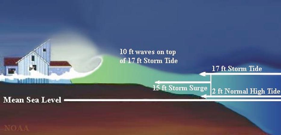
2 Background: Surge & Natural Defenses
3 Background: USACE Rule of Thumb : Storm Surge reduced 1 m per every 2.7 km of marsh Basis: Report correlated storm surge elevations for seven storms occurring across Southern Louisiana between 1909 and 1957 (Corps of Engineers, 1963). Scatter: Attenuation rates range from 1 m per 60 km to 1 m per 5 km (differing by a factor of 12). (Wamsley et al., 2010). 3
4 Objectives Specific Aim: Improved scientific understanding of storm surge flow in coastal wetlands Field Work Characterization of Vegetation Water level monitoring High Performance Computing Geospatial Analysis ADCIRC + SWAN 4


5 Field Work Vegetation Survey Water level Monitoring 5


6 Vegetation Characteristics: Summer & Winter 2015 Frontal Area Biomass Bio-mechanical Properties Seasonal Variation 6


7 Water Level Monitoring EVNWR: Tidal Records EVNWR Water Levels DMNAP Water Levels EVNWR Barometric Pressure 7


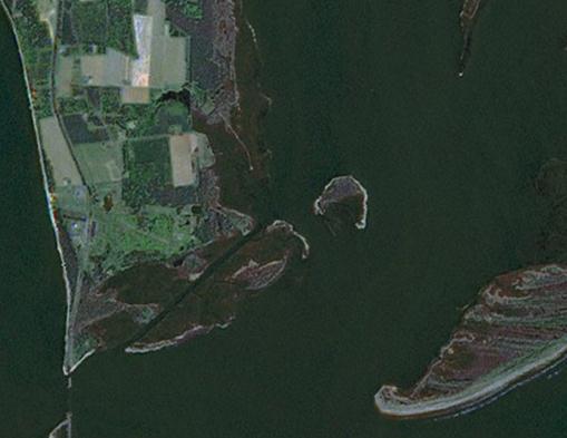
8 Monitoring Sites Dameron Marsh Natural Area Preserve Magothy Bay Natural Area Preserve Eastern Shore of Virginia National Wildlife Refuge 8

9 Eastern Shore of Virginia National Wildlife Refuge 9

10 Magothy Bay Natural AreaPreserve 10


11 Dameron Marsh Natural Area Preserve 11
")

12 Water Level Data Sensor 5 (ESVNWR) Sensor 4 Sensor 3 Sensor 2 Sensor 1 Preliminary Data: 12

13 Data Availability 13
14 Field Work: Next Steps Vegetation Characterization (Summer 2015) Increase water level monitoring capabilities 14

15 HPC: Modeling Storm Surge Stampede Cluster at U. Texas 15


16 High Performance Computing Storm Surge Model: Coupled ADCIRC + SWAN Base Mesh: FEMA Region III Photo courtesy of caseydietrich.com 16

17 Model Forcing: HURDAT Hurricane Isabel (2003) Hurricane Floyd (1999) 17

")

18 Model Validation: Hurricane Isabel (2003) 18


19 Model Sensitivity: Resolution FEMA Region III 100m Topo-bathy 50 50m Topo-bathy 10 10m 19

20 Sensitivity Results: 100m vs 10m Resolution 20


21 Model Sensitivity: Friction Uniform Manning s n at selected nodes Manning s n from NLCD 21

22 Spatial Scale: > 2km NLCD Friction High Friction 22


23 Model Sensitivity: Friction 23


24 Spatial Scale: <2km NLCD Friction High Friction 24

25 Sensitivity Results: High, Low, NLCD 25
26 Sensitivity Results: High, Low, NLCD 26
27 USACE Revisited Rule of Thumb : Storm Surge reduced 1 m per every 2.7 km of marsh That can t be right?... Modeling Results: Also show high degree of scatter even at the same spatial scale Potential Drivers: Storm Characteristics Geographic Context 27
28 Future Work Field Work: Vegetation Characterization (Summer 2015) Increase water level monitoring capabilities Modeling: Conclude Sensitivity Analysis Sub-domain Modelling Engineering: Evaluate Design Alternatives 28


29 Questions? The views expressed herein are those of the research group and do not necessarily reflect views of our sponsors or any sub agencies. The use of trade names does not constitute an endorsement in the use of these products by the U.S. Government 29
30 References Choi, J. and Harvey, J.W., Relative significance of microtopography and vegetation as controls on surface water flow on a low-gradient floodplain, Wetlands, doi: /s United States Army Corps of Engineering (1963), US Army District, New Orleans, Interim Survey Report, Morgan City, Louisiana and Vicinity, serial n. 63. Wamsley, T.;Cialone, M.; Smith, J.M.; Ebersole, B.A. and Grzegorzewski, A. S. (2010). "The potential of wetlands in reducing storm surge." Ocean Engineering, Wu, W., Ozeren, Y., Wren, D.G., Chen, Q., Zhang, G., Holland, M., Ding, Y., Kuiry, S.N., Zhang, M., Jadhave, R., Chatagnier, J., Chen, Y., Gordji, L Investigation of surge and wage reduction by vegetation: final report of phase I. Laboratory Publication. 1:315. Wu, W., Ozeren, Y., Wren, D.G., Chen, Q., Zhang, G., Holland, M., Ding, Y., Kuiry, S.N., Zhang, M., Jadhave, R., Chatagnier, J., Chen, Y., Gordji, L Investigation of surge and wage reduction by vegetation: final report of phase I. Laboratory Publication. 1:
Civil, Environmental, and Infrastructure Engineering VOLGENAU SCHOOL OF ENGINEERING
 Civil, Environmental, and Infrastructure Engineering VOLGENAU SCHOOL OF ENGINEERING Wetlands as a nature-based coastal defense A numerical modeling and field data integration approach to quantify storm
Assessing the relevance of wetlands for storm surge protection: a coupled hydrodynamic and geospatial framework
 Civil, Environmental, and Infrastructure Engineering VOLGENAU SCHOOL OF ENGINEERING Assessing the relevance of wetlands for storm surge protection: a coupled hydrodynamic and geospatial framework Jana
Dissipation due to Vegetation in Nearshore Wave Models
 Dissipation due to Vegetation in Nearshore Wave Models Jane McKee Smith US Army Engineer Research and Development Center, Coastal and Hydraulic Laboratory Alison Sleath Grzegorzewski, New Orleans District
Miami-Dade County Technical Update Meeting South Florida Coastal Study. May 11, 2016
 Miami-Dade County Technical Update Meeting South Florida Coastal Study May 11, 2016 Welcome and Introductions FEMA Region IV Christina Lindemer Technical Lead Production and Technical Services (PTS) Contractor
Influence of Marsh Restoration and Degradation on Storm Surge and Waves
 Influence of Marsh Restoration and Degradation on Storm Surge and Waves by Ty V. Wamsley, Mary A. Cialone, Joannes Westerink, and Jane M. Smith PURPOSE: The purpose of this CHETN is to examine storm surge
THE IMPORTANCE OF SCIENCE IN COASTAL RESTORATION IN LOUISIANA
 THE IMPORTANCE OF SCIENCE IN COASTAL RESTORATION IN LOUISIANA Barb Kleiss USACE, Mississippi Valley Division August 3, 2011 LCA S&T Office Authorized under WRDA 2007 Designed to address technical issues
2013 Louisiana Transportation Conference
 2013 Louisiana Transportation Conference Background FHWA/AASHTO study Objectives of LADOTD study Level III methodology Surge/Wave force methodology 100-Year Surge-Wave GIS Atlas Summary Questions Pensacola,
An Integrated Storm Surge, Hurricane Wave, Salinity and Sediment Transport Modeling System for Breton Sound, LA
 An Integrated Storm Surge, Hurricane Wave, Salinity and Sediment Transport Modeling System for Breton Sound, LA Q. Jim Chen Department of Civil and Environmental Engineering qchen@lsu.edu Acknowledgements
Benchmarking of Hydrodynamic Models for Development of a Coupled Storm Surge Hazard-Infrastructure Modeling Method to improve Inundation Forecasting
 Benchmarking of Hydrodynamic Models for Development of a Coupled Storm Surge Hazard-Infrastructure Modeling Method to improve Inundation Forecasting Abstract Fragility-based models currently used in coastal
COASTAL DATA APPLICATION
 2015 Coastal GeoTools Proactive By Design. Our Company Commitment COASTAL DATA APPLICATION Projecting Future Coastal Flood Risk for Massachusetts Bay Bin Wang, Tianyi Liu, Daniel Stapleton & Michael Mobile
Research Topic Updated on Oct. 9, 2014
 Research Topic Updated on Oct. 9, 2014 Wave Attenuation by Vegetation Sponsored by SERRI, DHS Lab/Field Experiments & Computational Modeling Ole Miss, LSU, NSL 2 Research Team PI: Dr. Weiming Wu Computational
Storm Surge Frequency Analysis using a Modified Joint Probability Method with Optimal Sampling (JPM-OS)
") Storm Surge Frequency Analysis using a Modified Joint Probability Method with Optimal Sampling (JPM-OS) Jay Ratcliff Coastal Hydraulics Lab, of Engineers (USACE) Engineering Research and Development Center
Storm Surge Frequency Analysis using a Modified Joint Probability Method with Optimal Sampling (JPM-OS) Jay Ratcliff Coastal Hydraulics Lab, of Engineers (USACE) Engineering Research and Development Center
Appendix A STORM SURGE AND WAVE HEIGHT ANALYSIS
 Appendix A STORM SURGE AND WAVE HEIGHT ANALYSIS Memo To: Jeff Robinson, P.E., GEC, Inc. From: Silong Lu, Ph.D., P.E., D.WRE, Dynamic Solutions, LLC. Date: 1/9/2014 CC: Re: Chris Wallen, Vice President,
Wetland attenuation of Hurricane Rita s storm surge
 Wetland attenuation of Hurricane Rita s storm surge Pat Fitzpatrick, Yee Lau, Yongzuo Li, Nam Tran, Chris Hill, and Suzanne Shean Geosystems Research Institute, Mississippi State University Sponsors: NOAA
South Florida Coastal Storm Surge and Mapping Study
 South Florida Coastal Storm Surge and Mapping Study Presented by Christopher Bender, Ph.D., P.E., D.CE June 2, 2015 Presentation Overview FEMA risk studies outline Overview South Florida surge study Work
US Army Corps of Engineers BUILDING STRONG. Mary Cialone, Norberto Nadal-Caraballo, and Chris Massey
 North Atlantic Coast Comprehensive Study Storm Selection and Numerical Modeling An Overview Computing the Joint Probability of Storm Forcing Parameters from Maine to Virginia Mary Cialone, Norberto Nadal-Caraballo,
Modeling Nearshore Waves for Hurricane Katrina
 Modeling Nearshore Waves for Hurricane Katrina Jane McKee Smith US Army Engineer Research & Development Center Coastal and Hydraulics Laboratory Outline Introduction Modeling Approach Hurricane Katrina
Chesapeake Bay Seminar Series
 Chesapeake Bay Seminar Series Sea level rise and coastal change: What the last several hundred years and Hurricane Isabel tell us about future coastal vulnerability in Chesapeake Bay Michael Kearney (Department
Computational Methods for Storm Surge
 Computational Methods for Storm Surge Columbia University Department of Applied Physics and Applied Mathematics 1 Source: Jocelyn Augustino / FEMA - http://www.fema.gov/photdata/original/38891.jpg Storm
Computing the Joint Probability of Hurricane Sandy and Historical Coastal Storm Forcing Parameters from Maine to Virginia
 Computing the Joint Probability of Hurricane Sandy and Historical Coastal Storm Forcing Parameters from Maine to Virginia Chris Massey and Jeff Melby USACE-ERDC Coastal & Hydraulics Lab Chris.Massey@usace.army.mil
THC-T-2013 Conference & Exhibition
 Modeling of Shutter Coastal Protection against Storm Surge for Galveston Bay C. Vipulanandan, Ph.D., P.E., Y. Jeannot Ahossin Guezo and and B. Basirat Texas Hurricane Center for Innovative Technology (THC-IT)
ADCIRC Based Storm Surge Analysis of Sea Level Rise in the Corpus Christi Bay Area
 the Corpus Christi Bay Area Publication CBBEP 86 Project Number 1306 July 2013 Prepared by ARCADIS U.S., Inc. 630 Plaza Drive Suite 200 Highlands Ranch, Colorado 80129 Submitted to: Coastal Bend Bays &
FEMA REGION III COASTAL HAZARD STUDY
 FEMA REGION III COASTAL HAZARD STUDY Impacts and Rollout June 11, 2013 Robin Danforth, FEMA Region III David Bollinger, FEMA Region III Jeff Gangai, RAMPP Christine Worley, RAMPP 1 Today s Discussion Overview
Forecast Predictions of Winds, Waves and Storm Surge during Hurricane Arthur (2014)
") Forecast Predictions of Winds, Waves and Storm Surge during Hurricane Arthur (2014) R Cyriac 1, JC Dietrich 1, JG Fleming 2, BO Blanton 3, RA Luettich Jr 4, C Kaiser 5 1 Dept. of Civil, Construction, and
Forecast Predictions of Winds, Waves and Storm Surge during Hurricane Arthur (2014) R Cyriac 1, JC Dietrich 1, JG Fleming 2, BO Blanton 3, RA Luettich Jr 4, C Kaiser 5 1 Dept. of Civil, Construction, and
The Coastal Change Analysis Program and the Land Cover Atlas. Rebecca Love NOAA Office for Coastal Management
 The Coastal Change Analysis Program and the Land Cover Atlas Rebecca Love NOAA Office for Coastal Management Natural Infrastructure = Greater Resilience NOAA C-CAP Regional Land Cover and Change coast.noaa.gov/digitalcoast/data/ccapregional
Phase II Storm Surge Analysis
 Phase II Storm Surge Analysis Post 45 Project, Charleston, SC Prepared for: USACE Charleston District Charleston, SC Prepared by: Water Environment Consultants Mount Pleasant, SC October 21, 2016 Table
Sea Level Rise and Hurricane Florence storm surge research methodology
 Sea Level Rise and Hurricane Florence storm surge research methodology Hurricane Florence storm surge analysis was conducted using a variety of input sources. In order to determine the maximum storm surge
A Longitudinal Analysis of the Drivers of Power Outages During Hurricanes: A Case Study with Hurricane Isaac
 A Longitudinal Analysis of the Drivers of Power Outages During Hurricanes: A Case Study with Hurricane Isaac Gina Tonn a*, Seth Guikema a, Celso Ferreira b, and Steven Quiring c a Johns Hopkins University,
Case 1:05-cv SGB Document Filed 11/12/13 Page 1 of 18
 Case 1:05-cv-01119-SGB Document 241-14 Filed 11/12/13 Page 1 of 18 Table of Contents Purpose of the Study Principal Findings Expert Background and Qualifications ADCIRC Models ADCIRC Models for Southern
Probabilistic Assessment of Coastal Storm Hazards
 Resilience of Coastal Infrastructure Conference Hato Rey, PR March 8-9, 2017 Probabilistic Assessment of Coastal Storm Hazards Dr. Norberto C. Nadal-Caraballo Leader, Coastal Hazards Group Team: Victor
PREDICTING TROPICAL CYCLONE FORERUNNER SURGE. Abstract
 PREDICTING TROPICAL CYCLONE FORERUNNER SURGE Yi Liu 1 and Jennifer L. Irish 1 Abstract In 2008 during Hurricane Ike, a 2-m forerunner surge, early surge arrival before tropical cyclone landfall, flooded
NORTH ATLANTIC COAST COMPREHENSIVE STUDY (NACCS) STORM MODELING AND STATISTICAL ANALYSIS FOR
 STORM MODELING AND STATISTICAL ANALYSIS FOR") NORTH ATLANTIC COAST COMPREHENSIVE STUDY (NACCS) STORM MODELING AND STATISTICAL ANALYSIS FOR 237 237 217 217 200 200 80 27 252 174.59 COMPUTING 255 0 163 COASTAL 131 239 110 HAZARDS 112 62 255 255 0 0
NORTH ATLANTIC COAST COMPREHENSIVE STUDY (NACCS) STORM MODELING AND STATISTICAL ANALYSIS FOR 237 237 217 217 200 200 80 27 252 174.59 COMPUTING 255 0 163 COASTAL 131 239 110 HAZARDS 112 62 255 255 0 0
ERDC Support for Hurricane Sandy
 ERDC Support for Hurricane Sandy Chris Massey, CHL; Aaron Byrd, CHL; Nawa Pradhan, CHL; Jeff Melby, CHL; Jane Smith, CHL; Robert Walker, ITL; and Jennifer Wozencraft, JALBTCX ERDC Support for Hurricane
Flood and Sea Level Rise Mapping Methodologies: The Way Forward
 Flood and Sea Level Rise Mapping Methodologies: The Way Forward Malcolm L. Spaulding Professor Emeritus, Ocean Engineering University of Rhode Island spaulding@egr.uri.edu Interagency Coordination Meeting
Location: Jacksonville, FL December 11, 2012
 Technical Update Meeting Northeast Florida Surge Study Location: Jacksonville, FL December 11, 2012 Agenda 2:00 2:15 Welcome/Introductions Tucker Mahoney, FEMA Region IV Michael DelCharco, BakerAECOM 2:15
Report on the Damage Survey Caused by Hurricane Katrina (Tentative Report)
") Report on the Damage Survey Caused by Hurricane Katrina (Tentative Report) November 1, 2005 Coastal Disaster Prevention Technology Survey Team 1. Introduction Hurricane Katrina struck the United States
Report on the Damage Survey Caused by Hurricane Katrina (Tentative Report) November 1, 2005 Coastal Disaster Prevention Technology Survey Team 1. Introduction Hurricane Katrina struck the United States
MEMORANDUM FOR SWG
 MEMORANDUM FOR SWG-2007-1623 Subject: Jurisdictional Determination (JD) for SWG-2007-1623 on Interdunal Wetlands Adjacent to Traditional Navigable Waters (TNWs) Summary The U.S. Environmental Protection
Storm Surge Analysis Update Meeting Cross City, Florida June 17, 2014
 Big Bend Coastal Storm Surge Study Storm Surge Analysis Update Meeting Cross City, Florida June 17, 2014 Introductions Risk MAP Project Team FEMA Region IV Florida Division of Emergency Management (FDEM)
THE NEW STORM SURGE MODULE IN AIR S U.S. HURRICANE MODEL
 THE NEW STORM SURGE MODULE IN AIR S U.S. HURRICANE MODEL Hurricane Ike storm surge devastation of Bolivar Peninsula near Galveston, Texas. (Source: Chuck Davis, flickr) When a hurricane comes onshore,
Simulation of storm surge and overland flows using geographical information system applications
 Coastal Processes 97 Simulation of storm surge and overland flows using geographical information system applications S. Aliabadi, M. Akbar & R. Patel Northrop Grumman Center for High Performance Computing
Coastal Emergency Risks Assessment - CERA Real-Time Storm Surge and Wave Visualization Tool
 Coastal Emergency Risks Assessment - CERA Real-Time Storm Surge and Wave Visualization Tool Introduction This document provides guidance for using the Coastal Emergency Risks Assessment (CERA) visualization
Background and Purpose of Meeting. River Towers Meeting. Flood Risk Management Study Alternatives Overview
 1 and Purpose of Meeting River Towers Meeting Flood Risk Management Study Alternatives Overview September 23, 2014 There is no "proposed" flood risk management solution for this area at this time Fairfax
3Chapter Three: Rescue and Response
 17 16 Report Science Title and the Storms: the USGS Response to the Hurricanes of 2005 3Chapter Three: Rescue and Response This chapter documents the U.S. Geological Survey s (USGS) humanitarian rescue
Identification and Selection of Representative Storm Events from a Probabilistic Storm Data Base
 Identification and Selection of Representative Storm Events from a Probabilistic Storm Data Base by Mark B. Gravens and Dylan R. Sanderson PURPOSE: This Coastal and Hydraulics Engineering Technical Note
An analysis of storm surge attenuation by wetlands using USGS, FEMA, and NASA data
 An analysis of storm surge attenuation by wetlands using USGS, FEMA, and NASA data Pat Fitzpatrick Geosystems Research Institute Mississippi State University Walter Peterson and Courtney Buckley NASA Marshall
ERDC S COASTAL STORM MODELING SYSTEM COASTAL TEXAS, USA
 ERDC S COASTAL STORM MODELING SYSTEM COASTAL TEXAS, USA Chris Massey Research Mathematician, USACE-ERDC Coastal & Hydraulics Lab Chris.Massey@usace.army.mil 1 st Int. Workshop on Waves, Storm Surge and
Whiskey Island Marsh Creation Rolling with the Punches
 Whiskey Island Marsh Creation Rolling with the Punches Santiago Alfageme, M&N Jerry Carroll, LADNR Brad Miller, LADNR Project Location Historic Island Retreat Previous Restoration Project Whiskey Island
Daily Operations Briefing. Wednesday, August 23, :30 a.m. EDT
 Daily Operations Briefing Wednesday, August 23, 2017 8:30 a.m. EDT Significant Activity August 22-23 Significant Events: Tropical Weather Threat Gulf Coast Tropical Activity: Atlantic Disturbance 1 High
How will mangrove encroachment and eroding impoundments impact coastal protection?
 How will mangrove encroachment and eroding impoundments impact coastal protection? A Case Study in the Merritt Island National Wildlife Refuge Cheryl Doughty 1, Kyle Cavanaugh 1, & Samantha Chapman 2 1
Construction complete on all HSDRRS projects across storm evacuation routes
 Task Force Hope Status Report August 29, 2013 Construction complete on all HSDRRS projects across storm evacuation routes Eastern Tie-In Swing Gates positioned across Hwy. 23 By Susan Spaht If a tropical
Effects of input DEM data spatial resolution on Upstream Flood modeling result A case study in Willamette river downtown Portland
 Effects of input DEM data spatial resolution on Upstream Flood modeling result A case study in Willamette river downtown Portland By Hue Duong GEOG 593 Fall 2015 Digital Terrain Analysis Photo: Anh Duc
Final Results and Outreach Lessons Learned
 FEMA REGION III COASTAL HAZARD STUDY Final Results and Outreach Lessons Learned June 4, 2014 Mari Radford Christine Worley Robin Danforth David Bollinger FEMA Region III RAMPP FEMA Region III FEMA Region
A multi-tiered ADCIRC-based storm surge and wave prediction system
 A multi-tiered ADCIRC-based storm surge and wave prediction system Brian Blanton, Renaissance Computing Institute, UNC-Chapel Hill Rick Luettich, Institute of Marine Sciences, UNC-Chapel Hill, co-pi Jason
HURRICANE IVAN CHARACTERISTICS and STORM TIDE EVALUATION
 HURRICANE IVAN CHARACTERISTICS and STORM TIDE EVALUATION By Robert Wang and Michael Manausa Sponsored by Florida Department of Environmental Protection, Bureau of Beaches and Coastal Systems Submitted
Hurricane Isaac: A Longitudinal Analysis of Storm Characteristics and Power Outage Risk
 Risk Analysis, Vol. 36, No. 10, 2016 DOI: 10.1111/risa.12552 Hurricane Isaac: A Longitudinal Analysis of Storm Characteristics and Power Outage Risk Gina L. Tonn, 1, Seth D. Guikema, 2 Celso M. Ferreira,
USACE-ERDC Coastal Storm Modeling System Updates Chris Massey, PhD
 USACE-ERDC Coastal Storm Modeling System Updates Chris Massey, PhD Research Mathematician USACE-ERDC Coastal & Hydraulics Lab Chris.Massey@usace.army.mil ERDC s Coastal Storm-Modeling System (ERDC CSTORM-MS)
Hurricane Isaac: A Longitudinal Analysis of Storm Characteristics and Power Outage Risk
 Hurricane Isaac: A Longitudinal Analysis of Storm Characteristics and Power Outage Risk Gina Tonn 1*, Seth Guikema 2, Celso Ferreira 3, and Steven Quiring 4 Abstract In August 2012, Hurricane Isaac, a
Estimation of Wave Heights during Extreme Events in Lake St. Clair
 Abstract Estimation of Wave Heights during Extreme Events in Lake St. Clair T. J. Hesser and R. E. Jensen Lake St. Clair is the smallest lake in the Great Lakes system, with a maximum depth of about 6
Geology Setting Management Options Management Structure
 Geology Setting Management Options Management Structure WFF = Wallops Flight Facility LST = Longshore sediment transport SLR = Sea level rise September 29, 2015 Accomack County/Accomack Northampton County
PROBABILISTIC DESIGN METHOD OF LEVEE AND FLOODWALL HEIGHTS FOR THE HURRICANE PROTECTION SYSTEM IN THE NEW ORLEANS AREA
 PROBABILISTIC DESIGN METHOD OF LEVEE AND FLOODWALL HEIGHTS FOR THE HURRICANE PROTECTION SYSTEM IN THE NEW ORLEANS AREA Mathijs van Ledden Haskoning Inc., 1 Galleria Blvd., Metairie, LA70001, United States,
Coupled, Unstructured Grid, Wave and Circulation Models: Validation and Resolution Requirements
 Coupled, Unstructured Grid, Wave and Circulation Models: Validation and Resolution Requirements J.C. Dietrich, J.J. Westerink University of Notre Dame C. Dawson University of Texas at Austin M. Zijlema,
SAGE. Systems Approach to Geomorphic Engineering. Barnegat Bay Pilot. Heather Jensen Philadelphia District. US Army Corps of Engineers BUILDING STRONG
 SAGE Systems Approach to Geomorphic Engineering Barnegat Bay Pilot Heather Jensen Philadelphia District US Army Corps of Engineers SAGE Nationwide program with a Regional Approach Innovative approach to
An Ensemble based Reliable Storm Surge Forecasting for Gulf of Mexico
 An Ensemble based Reliable Storm Surge Forecasting for Gulf of Mexico Umer Altaf Delft University of Technology, Delft ICES, University of Texas at Austin, USA KAUST, Saudi Arabia JONSMOD 2012, Ifremer,
The Use of Geographic Information Systems to Assess Change in Salt Marsh Ecosystems Under Rising Sea Level Scenarios.
 The Use of Geographic Information Systems to Assess Change in Salt Marsh Ecosystems Under Rising Sea Level Scenarios Robert Hancock The ecological challenges presented by global climate change are vast,
ERDC S COASTAL STORM MODELING SYSTEM (AND APPLICATIONS)
") ERDC S COASTAL STORM MODELING SYSTEM (AND APPLICATIONS) Chris Massey Research Mathematician, USACE-ERDC Coastal & Hydraulics Lab Chris.Massey@usace.army.mil November 1-2, 2017 Team Acknowledgements Hung
ERDC S COASTAL STORM MODELING SYSTEM (AND APPLICATIONS) Chris Massey Research Mathematician, USACE-ERDC Coastal & Hydraulics Lab Chris.Massey@usace.army.mil November 1-2, 2017 Team Acknowledgements Hung
2016 NC Coastal Local Governments Annual Meeting
 6 NC Coastal Local Governments Annual Meeting NCFMP Coastal Map Maintenance Flood Study Updates and Changes April, 6 Tom Langan, PE, CFM Engineering Supervisor NCEM-Risk Management - Floodplain Mapping
Erosion Information Paper - South Naknek, Alaska Current as of November 14, 2007
 U.S. Army Corps of Engineers ALASKA BASELINE EROSION ASSESSMENT Erosion Information Paper - South Naknek, Alaska Current as of November 14, 2007 Community Information South Naknek (NACK-neck), originally
Robert Weaver, Donald Slinn 1
 1 1 Robert Weaver, Donald Slinn 1 Department of Civil and Coastal Engineering, University of Florida, Gainesville, Florida Supported by the US Office of Naval Research AGU Fall Meeting 2002 Poster OS72A-0342
Development of Operational Storm Surge Guidance to Support Total Water Predictions
 Development of Operational Storm Surge Guidance to Support Total Water Predictions J. Feyen 1, S. Vinogradov 1,2, T. Asher 3, J. Halgren 4, Y. Funakoshi 1,5 1. NOAA/NOS//Development Laboratory 2. ERT,
Analysis of Tides and Storm Surge from Observational Records in the Delaware Inland Bays
 Analysis of Tides and Storm Surge from Observational Records in the Delaware Inland Bays John Callahan Delaware Geological Survey Coastal GeoTools Conference March 30 April 2, 2015 Charleston, SC Outline
Planning for Annapolis Sea Level Rise and Future Extreme Water Levels
 Planning for Annapolis Sea Level Rise and Future Extreme Water Levels U.S. Naval Academy Sea Level Rise Advisory Council 31 October 2017 CAPT Emil Petruncio, USN (Ret.), PhD Associate Professor Gina Henderson
IMAGE AND DATA CREDITS
 Image credits All images created by Keranen and Image (figure 03_basics_a.tif) from ArcGIS Help 10.2 http://resources.arcgis.com/en/help /main/10.2/index.html#/015w0000006n000000, courtesy of Esri. Image
Harrison 1. Identifying Wetlands by GIS Software Submitted July 30, ,470 words By Catherine Harrison University of Virginia
 Harrison 1 Identifying Wetlands by GIS Software Submitted July 30, 2015 4,470 words By Catherine Harrison University of Virginia cch2fy@virginia.edu Harrison 2 ABSTRACT The Virginia Department of Transportation
Conrad Blucher Institute for Surveying and Science
 d James Rizzo Assistant irector of Operations - Office: 361-825-5758 Mobile: 361-549-5120 james.rizzo@tamucc.edu d d Texas Coastal Ocean Observation N Network (TCOON) Began in 1988 with 2 stations in Bay
HFIP- Supported Improvements to Storm Surge Forecas6ng in 2012
 HFIP- Supported Improvements to Storm Surge Forecas6ng in 2012 Jesse C. Feyen (NOS/OCS), Jamie Rhome (NWS/NHC), Rick LueJch (UNC- CH), Jason Fleming (Seahorse Consul6ng), Brian Blanton (RENCI), Yuji Funakoshi
Simulating Hurricane Storm Surge in the Lower Mississippi River under Varying Flow Conditions
 Simulating Hurricane Storm Surge in the Lower Mississippi River under Varying Flow Conditions R. C. Martyr, M.ASCE 1 ; J. C. Dietrich 2 ; J. J. Westerink, M.ASCE 3 ; P. C. Kerr 4 ; C. Dawson 5 ; J. M.
Simulating Hurricane Storm Surge in the Lower Mississippi River under Varying Flow. Westerink 1
 1 2 3 4 5 Simulating Hurricane Storm Surge in the Lower Mississippi River under Varying Flow Conditions R.C. Martyr 1*, J.C. Dietrich 2, J.J. Westerink 1, P.C. Kerr 1, C. Dawson 2, J.M. Smith 3, H. Pourtaheri
PART 4 HURRICANE KATRINA STRIKES NEW ORLEANS AUGUST 2005
 PART 4 HURRICANE KATRINA STRIKES NEW ORLEANS AUGUST 2005 Hurricane Katrina Hurricane Katrina swept across southern Florida and lost momentum, then gained speed and water, showing the second lowest barometric
A GEOSPATIAL FRAMEWORK TO ESTIMATE DEPTH OF SCOUR UNDER BUILDINGS DUE TO STORM SURGE IN COASTAL AREAS
 A GEOSPATIAL FRAMEWORK TO ESTIMATE DEPTH OF SCOUR UNDER BUILDINGS DUE TO STORM SURGE IN COASTAL AREAS Committee: by Mariamawit Borga A Thesis Submitted to the Graduate Faculty of George Mason University
CLIMATE CHANGE IN HAMPTON ROADS PHASE III: SEA LEVEL RISE IN HAMPTON ROADS, VIRGINIA
 CLIMATE CHANGE IN HAMPTON ROADS PHASE III: SEA LEVEL RISE IN HAMPTON ROADS, VIRGINIA This report was funded, in part, by the Virginia Coastal Zone Management Program at the Virginia Department of Environmental
The reduction of storm surge by vegetation canopies: Three-dimensional simulations
 GEOPHYSICAL RESEARCH LETTERS, VOL. 39,, doi:10.1029/2012gl053577, 2012 The reduction of storm surge by vegetation canopies: Three-dimensional simulations Y. Peter Sheng, 1 Andrew Lapetina, 1 and Gangfeng
COASTAL WETLAND ENGINEERING: DESIGNING FOR FUNCTION, CASE STUDIES, AND MODELING TOOLS
 COASTAL WETLAND ENGINEERING: DESIGNING FOR FUNCTION, CASE STUDIES, AND MODELING TOOLS Candice Piercy, PhD, PE Susan Bailey, PE ERDC - Environmental Laboratory TAMU Ocean Engineering EWN Lecture Series
Coastal and Hydraulics Laboratory
 ERDC/CHL TR-11-1 FEMA Region III Storm Surge Study Coastal Storm Surge Analysis: Computational System Report 2: Intermediate Submission No. 1.2 Brian Blanton, Lisa Stillwell, Hugh Roberts, John Atkinson,
Earth Wind & Fire. Game Changing Restoration Options in the Texas Chenier Plain
 Earth Wind & Fire Game Changing Restoration Options in the Texas Chenier Plain EARTH: The Chenier Plain is a 5 million acre coastal region in Southwest Louisiana and Southeast Texas providing landscape
EVALUATION TECHNIQUES FOR THE PROTECTIVE BENEFITS OF DUNE SYSTEMS TO COASTAL HAZARDS
 EVALUATION TECHNIQUES FOR THE PROTECTIVE BENEFITS OF DUNE SYSTEMS TO COASTAL HAZARDS 5 th Coastal Hazards Symposium Key West 2015 Matthew Janssen Thomas Herrington Jon Miller 1 Abstract Quantify and predict
Adaptation to Sea Level Rise A Regional Approach
 Adaptation to Sea Level Rise A Regional Approach Project Partners: in Saco Bay, ME Peter Slovinsky, Marine Geologist Maine Geological Survey, Department of Conservation Project Funding from: Saco Bay Hazards
COASTAL EVOLUTION AND CLIMATE CHANGE: CHALLENGES OF MULTI-SCALE SPATIAL AND TEMPORAL VARIABILITY
 COASTAL EVOLUTION AND CLIMATE CHANGE: CHALLENGES OF MULTI-SCALE SPATIAL AND TEMPORAL VARIABILITY Dr. Jennifer L. Miselis Naval Research Laboratory Stennis Space Center, MS jmiselis@nrlssc.navy.mil 1 PRIMARY
STORM TIDE HINDCASTS FOR HURRICANE HUGO: INTO AN ESTUARINE AND RIVERINE SYSTEM
 ADVANCES IN HYDRO-SCIENCE AND ENGINEERING, VOLUME VI 1 STORM TIDE HINDCASTS FOR HURRICANE HUGO: INTO AN ESTUARINE AND RIVERINE SYSTEM Scott C. Hagen 1, Daniel Dietsche 2, and Yuji Funakoshi 3 ABSTRACT
6 - STORM SURGES IN PUERTO RICO_Power Plants-Aguirre. Aguirre
 1 6 - STORM SURGES IN PUERTO RICO_Power Plants-Aguirre Aguirre Figure 1 shows a GE image of the Aguirre Electric Power Plant inside Jobos Bay. Figure 2 shows a picture of the plant looking at base level
MISSISSIPPI COASTAL IMPROVEMENTS
 MISSISSIPPI COASTAL IMPROVEMENTS PROGRAM (MsCIP) Comprehensive Barrier 237 27 200 237 27 200 Island 237 Restoration 27 200 Plan 80 9 27 252 74.59 255 255 255 0 0 0 63 63 63 3 32 22 239 65 53 0 35 20 2
Flooding in Western North Carolina: Some Spatial, Hydrologic, and Seasonal Characteristics CAUTION!! Outline. Basic Flood Facts.
 Flooding in Western North Carolina: Some Spatial, Hydrologic, and Seasonal Characteristics J. Greg Dobson CAUTION!! National Environmental Modeling and Analysis Center RENCI at UNC-Asheville Engagement
HAZUS th Annual Conference
 HAZUS 2014 7 th Annual Conference VALIDATING THE HAZUS COASTAL SURGE MODEL FOR SUPERSTORM SANDY Spiridon Katehis 1 Jordan T. Hastings 1 1 University of Southern California 1 Superstorm Sandy, Oct 12 2
Delaware Bay Dikes Repair and Prevention Project Preliminary Design for New Castle Dikes
 City of New Castle Presentation Delaware Bay Dikes Repair and Prevention Project Preliminary Design for New Castle Dikes New Castle Conservation District DNREC August 22, 2012 Agenda Project Background
Quantifying effects of oil on coastal dune vegetation. Thomas Miller and Elise Gornish Biological Science, Florida State University
 Quantifying effects of oil on coastal dune vegetation Thomas Miller and Elise Gornish Biological Science, Florida State University Natural History of Barrier Islands in the Northern Gulf Make up ~70% of
American Oystercatcher Monitoring in Virginia 2009 Update. Alexandra Wilke AOWG Annual Meeting Oyster, VA November 9, 2009
 American Oystercatcher Monitoring in Virginia 2009 Update Alexandra Wilke AOWG Annual Meeting Oyster, VA November 9, 2009 Alexandra Wilke (TNC), Ruth Boettcher (VA DGIF) Carissa Smith (VA DGIF) Barry Truitt
Surge Generation Mechanisms in the Lower Mississippi River and Discharge Dependency
 Case Study Surge Generation Mechanisms in the Lower Mississippi River and Discharge Dependency Downloaded from ascelibrary.org by UNIVERSITY OF NOTRE DAME on 06/12/13. Copyright ASCE. For personal use
Coastal Processes and Shoreline Erosion on the Oregon Coast, Cascade Head to Cape Kiwanda
 State of Oregon Department of Geology and Mineral Industries Vicki S. McConnell, State Geologist Open File Report OFR O-04-11 Coastal Processes and Shoreline Erosion on the Oregon Coast, Cascade Head to
Impacts of Hurricane Rita on the Beaches of Western Louisiana
 Impacts of Hurricane Rita on the Beaches of Western Louisiana By Hilary F. Stockdon, Laura A. Fauver, Asbury H. Sallenger, Jr., and C. Wayne Wright Hurricane Rita made landfall as a category 3 storm in
SOUTHEAST COASTAL ASSESSMENT: Creating a shared vision
 SOUTHEAST COASTAL ASSESSMENT: Creating a shared vision November 12, 2017 Jacqueline Keiser, PG, PMP Regional Sediment Management Regional Center of Expertise SOUTH ATLANTIC DIVISION U.S. ARMY CORPS OF
North Carolina Coastal Flood Analysis System Hurricane Parameter Development. Submittal Number 1, Section 5
 North Carolina Coastal Flood Analysis System Hurricane Parameter Development Submittal Number 1, Section 5 A Draft Report for the State of North Carolina Floodplain Mapping Project Technical Report TR-08-06