Near-Real Time SNPP VIIRS Ocean Color Products from NOAA Okeanos Operational Production System
|
|
|
- Steven Miller
- 5 years ago
- Views:
Transcription
1 Near-Real Time SNPP VIIRS Ocean Color Products from NOAA Okeanos Operational Production System Dr. Banghua Yan* NOAA Ocean Color Operational Product Area Lead NOAA/NESDIS/OSPO/Satellite Products Branch *Co-authors: D. Jacob, I. Simpson, E. Rodriguez, A. Irving, and STAR Coastwatch Team AMS Meeting, 01/23/2017 1
2 OUTLINE Who Are We? NOAA Okeanos Ocean Color Operational Production System Near-Real Time (NRT) Operational Ocean Color Products Product Access Information 2
3 National Oceanic and Atmospheric Administration (NOAA) Line Offices National Environmental Satellite, Data, and Information Service (NESDIS) Office of Satellite and Product Operations (OSPO) Center for Satellite Applications and Research (STAR) Joint Polar Satellite System (JPSS) Office of Satellite Ground Services (OSGS) Geostationary Operational Environmental Satellite R-Series (GOES-R) International and Interagency Affairs Division (IIAD) Office of System Architecture & Advanced Planning (OSAAP) National Centers for Environmental Information (NCEI) Office of Space Commerce (OSC) National Marine Fisheries Service National Ocean Service National Weather Service Office of Oceanic and Atmospheric Research Office of Marine & Aviation Operations (Reference: 3

 NOAA Center for Weather")
 Command")
 NSOF Fairbanks CDA NCWCP Wallops CDA (Courtesy of")
4 Office of Satellite and Product Operations (OSPO) Locations at four facilities housing about 700 OSPO staff NOAA Satellite Operations Facility (NSOF) in Suitland, MD Mission Operations Division (MOD) NOAA Center for Weather & Climate Prediction (NCWCP) in College Park, MD Satellite Product and Services Division (SPSD) Command and Data Acquisition (CDA) in AK and VA NOAA Ice Center (NIC) NSOF Fairbanks CDA NCWCP Wallops CDA (Courtesy of Matthew Seybold) 4
 Fire and Smoke Hurricane Intensity and Position Volcanic Ash And many more (Reference: http://www.ospo.noaa.gov/products/index.")
5 Supporting Products in SPSD Satellite Products Branch Ocean Color Arctic composite imagery Ocean Heat Content Coral Bleaching Sea Lake Ice Sea Surface Temperature Ozone & Atmospheric Chemistry Precipitation (Rain & Snow) Fire and Smoke Hurricane Intensity and Position Volcanic Ash And many more (Reference: 5
6 Why Is Ocean Color So Important? Retrieve chlorophyll concentration from satellite observation of ocean color; Estimate the amount and general type of phytoplankton from chlorophyll; Phytoplankton, the base of the oceanic food web, use sunlight and carbon dioxide to produce organic carbon (photosynthesis); Monitor health of oceanic ecosystem from phytoplankton, etc. Air Quality (Marine Isoprene emission) Hurricane Path Oceanic Oil Analysis Climate Change (CO2 during Photosynthesis) Ocean Color Water Quality (ocean acidification & turbidity) Ocean Current (Phytoplankt on drift along water) Harmful Algal Blooms Coastal Habitat of Species (at risk) Sediment Transport 6
7 NOAA Okeanos System Concept The Okeanos system is a flexible, expandable Linux-based system capable of processing multiple satellite streams to produce multiple types of ocean color products. Ocean Color Product Software Component NOAA Ocean Color CoastWatch Automatic Processing Software (CWAPS) package (P. DiGiacomo et al., NOAA/STAR) including MSL12 algorithm (M.H., Wang et al., NOAA/STAR) and BOA Chl frontal algorithm (I. Belkin, URI) Hardware Configuration Components: Process manager nodes Update and stage nodes Processor nodes Shared data storage FTP servers Thredds servers NRT QA Monitoring Tools GUI tool Web-based QA tool 7
8 NOAA Okeanos Operational Production System (OPS) IT Architecture NEW ESPC ENV Prod Zone... DMZ oc-opsproc01 oc-opsproc02 oc-opsproc18 VM Physical Storage oc-opsmgt01 oc-opsstg01 oc-opsweb01 oc-opsmgt02 oc-opsstg02 4 Gluster Storage Servers: oc-ops-gluster01 to oc-ops-gluster04 R/O R/O R/O oc-opstds01 oc-opsftp01 oc-opstds02 Users 8
9 NOAA Okeanos OPS NRT OC Products Processing Streams SNPP/VIIRS MODIS/Aqua CONUS HAB Products Stream (L2, L3 &L4) VIIRS SNPP Level 1 (NDE-PE1) CONUS True Color Products Stream (L2 & L3) Global MSL12 Products Stream ((L2, L3 & L4) Global True Color Products Stream (L2 & L3) MODIS Aqua Level 0 to Level-1B (MODIS Ingest Server) 4 MODIS/Aqua OC products Streams (L2, L3, & L4) 9
10 NOAA Okeanos NRT Operational Ocean Color Product Specifications Satellites: SNPP and Aqua Instruments: VIIRS and MODIS Product Specifications Product Parameter Name: Chl-a, Chl-a fronts, K490, Kpar, and Rrs Coverage: VIIRS: CONUS (Caribbean, Hawaii, Great Lakes, Gulf of Mexico, North East, Southeast, West Coast) + Global (24 sectors) MODIS: CONUS Format: netcdf, HDF, Tif, PNG Horizontal Resolution: VIIRS: 750 m (CONUS + Global Sectors) + 4 km (Global Merged) MODIS: 1 km Timeliness: 12 hours Data Latency: 12 hours Algorithms: VIIRS: NOAA MSL12 + BOASNRA MODIS: NASA l2gen + NOAA SWIR +BOASNRA Distribution: new ftps and Thredds servers (DAR submission and approval are required) Backup Distribution: ftp://cw-okeanos.noaa.gov/pub/ (anonymous ftp) 10
11 NOAA NRT Operational SNPP/VIIRS Ocean Color Products List Daily Merged CW 750m Daily Merge d single 4km Daily Merged sectorised Global@ 750m *61 day Merge d CW region 750m Anomaly for CW 750m Granule *7 Day Merged single 4km *7 Day Merged sectorise d Global@ 750m *True month Merged single 4km Chl-a X X X X X X X X X X nlws X X X X X X X Kd par X X X X X X X X Kd 490 X X X X X X X X Rrs 672 X X X X *True Month Merged sectorise d Global@ 750m Fronts True Color X X (3 sectors) X 11


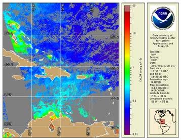


12 NOAA NRT Operational SNPP VIIRS OC Products: CONUS Coverage Caribbean Northeast Southeast Gulf of Mexico Great Lakes West Coast Hawaii 12

13 24 Sectors of Global VIIRS OC Products * Chl-a frontal Regions: UY, VY, and WY 13

14 NOAA NRT SNPP VIIRS OC Products: Example1 Global Chl-a 14

15 NOAA NRT SNPP VIIRS OC Products: Example2 Global KPAR 15
 MODIS Regions - Northeast (NE) - Southeast (SE) - Gulf of Mexico (GM) - Albers Projection - Gulf of Mexico (GM) - Mercator Projection - Carribbean (CB) - West")
16 Okeanos Web-based QA Imagery & Statistics Okeanos Images and Statistics are provided from the main page. (Statistics for Chl-a, K490 and KPAR) MODIS Regions - Northeast (NE) - Southeast (SE) - Gulf of Mexico (GM) - Albers Projection - Gulf of Mexico (GM) - Mercator Projection - Carribbean (CB) - West Coast (WC) - Alaska (AK) - East Tropical Pacific (EP) - Equatorial Atlantic (EA) - Great Lakes (GL) - Hawaii (HI) - North Atlantic (NA) - Pacific Basin (PB) - Chesapeake Bay (CY) Visit the link VIIRS CONUS Regions - Northeast (NE) - Southeast (SE) - Gulf of Mexico (GM) - Carribbean (CB) - West Coast (WC) - Great Lakes (GL) - Hawaii (HI) VIIRS Global Regions - 24 Sectors - Global Products (images) - Chlorophyll Concentration - Remote Sensing Reflectance - Chlorophyll Front - Kpar - K490 Products (Statistics) Time Series and Histograms - Chlorophyll - Kpar - K490 Products Quality Anomaly Monitoring - Chlorophyll Products Count Monitoring - Chlorophyll - Kpar - K490 16

17 Global SNPP VIIRS OC Products Histogram Tables 17
18 Monitor VIIRS OC Products Quality Anomaly 18
19 NOAA NRT Ocean Color Products Data Dissemination Flow Netcdf, HDF, TIF, & PNG Copy Okeanos FTP Server (sftp) L3 HDF FTP Pull CLASS Data Archive All users EMC/NMFS/HAB Netcdf, HDF, TIF, & PNG SCP & HTTP NOAA Coast Watch Web Server CoastWatch users Okeanos OPS (oc-opsmgt01/02) PNG SCP Okeanos QA Monitoring Tools All users PNG & Tif FTP Pull Netcdf, HDF & PNG HTTP PDA Okeanos External Thredds L3 PNG FTP Pull GeonetCast All users CoastWatch/ EMC/NMFS/HAB 19
20 NRT MODIS/Aqua and VIIRS Ocean Color Operational Products Access MODIS/Aqua Ocean Color Products ftp://cw-okeanos.noaa.gov/pub/data1/modis/ SNPP VIIRS OC products Short-term (by 2017) ftp://cw-okeanos.noaa.gov/pub/data1/viirs_test/ (netcdf, hdf, tiff, and png formats) Long-term: External Thredds server New Okeanos ftp server PDA (Submit a Data Access Request (DAR) form to nesdis.data.access@noaa.gov for approval) 20
NOAA Applications of OC data
 NOAA Applications of OC data Cara Wilson NOAA/NMFS/SWFSC/ERD 2017 IOCS Meeting, Lisbon, Portugal, May 16 NOAA poster presentations 2017 IOCS Meeting Name Foster et al. Hyde et al. Lance et al. Liu & Wang
NOAA Great Lakes CoastWatch Program
 Great Lakes Workshop Series on Remote Sensing of Water Quality May 7-8, 2014 NOAA GLERL, 4840 South State Rd, Ann Arbor, MI NOAA Great Lakes CoastWatch Program CoastWatch is a nationwide National Oceanic
Harmful Algal Blooms (HABs) 5 Applications
 5 Applications") Harmful Algal Blooms (HABs) 5 Applications Richard P. Stumpf NOAA, National Ocean Service HAB occurrences worldwide Image from whoi.edu/redtide HAB applications: short term Management: Monitoring and Response
Harmful Algal Blooms (HABs) 5 Applications Richard P. Stumpf NOAA, National Ocean Service HAB occurrences worldwide Image from whoi.edu/redtide HAB applications: short term Management: Monitoring and Response
Data Management for Algal Monitoring in the Gulf of Mexico
 Data Management for Algal Monitoring in the Gulf of Mexico Scott Cross NOAA National Oceanographic Data Center/ Coastal Data Development Center (NCDDC) Outline History Current & Future Directions Needs
Snowfall Detection and Rate Retrieval from ATMS
 Snowfall Detection and Rate Retrieval from ATMS Jun Dong 1, Huan Meng 2, Cezar Kongoli 1, Ralph Ferraro 2, Banghua Yan 2, Nai-Yu Wang 1, Bradley Zavodsky 3 1 University of Maryland/ESSIC/Cooperative Institute
GOES-16 & GOES-S: Natalia Donoho. Preparing Users for New Generation Satellites. WMO IPET-SUP-4 Geneva, Switzerland 26 February, 2018
 GOES-16 & GOES-S: Preparing Users for New Generation Satellites Natalia Donoho Satellite Products and Services Division (NOAA/NESDIS) WMO IPET-SUP-4 Geneva, Switzerland 26 February, 2018 GOES-R series
NOAA Update and Key Issues Dr. Stephen Volz, Assistant Administrator for Satellite and Information Services
 NOAA Update and Key Issues Dr. Stephen Volz, Assistant Administrator for Satellite and Information Services Space Studies Board Meeting April 28, 2016 NOAA Satellite and Information Service Outline NOAA
Evolution of NOAA s Observing System Integrated Analysis (NOSIA)
") Evolution of NOAA s Observing System Integrated Analysis (NOSIA) Presented to the 13th Symposium on Societal Applications: Policy, Research and Practice (paper 9.1) Louis Cantrell Jr., and D. Helms, R.
Evolution of NOAA s Observing System Integrated Analysis (NOSIA) Presented to the 13th Symposium on Societal Applications: Policy, Research and Practice (paper 9.1) Louis Cantrell Jr., and D. Helms, R.
JPSS GEONETCAST REQUIREMENTS DISCUSSION
 Joint Polar Satellite System (JPSS) JPSS GEONETCAST REQUIREMENTS DISCUSSION Mitch Goldberg Program Scientist Joint Polar Satellite System National Environmental Satellite, Data, and Information Service
Daily Operations Briefing Monday, December 26, :30 a.m. EST
 Daily Operations Briefing Monday, December 26, 2016 8:30 a.m. EST Significant Activity Dec 25-26 Significant Events: None Significant Weather: Heavy Snow Pacific Northwest, Northern Intermountain and the
Southern Florida to Cape Hatteras Spring Season Preview 2018 UPDATE ON U.S. EAST COAST GULF STREAM CONDITIONS
 Southern Florida to Cape Hatteras Spring Season Preview 2018 UPDATE ON U.S. EAST COAST GULF STREAM CONDITIONS By ROFFS Gregory J. Gawlikowski ROFFS continues its spring preview series by providing an overall
An Arctic Perspective NCEI's Prototype Arctic Data Viewer
 An Arctic Perspective NCEI's Prototype Arctic Data Viewer NCEI Arctic Action Team Kate Rose NOAA National Environmental Satellite, Data, and Information Service National Centers for Environmental Information
New NASA Ocean Observations and Coastal Applications
 New NASA Ocean Observations and Coastal Applications Duane Armstrong Chief, Applied Science & Technology Project Office August 20, 2014 1 Outline NASA s new Earth Science Ocean Science Missions for 2014
NOAA Direct Broadcast Real-Time Network Status
 NOAA Direct Broadcast Real-Time Network Status Liam Gumley (CIMSS/SSEC/UW-Madison) Mitch Goldberg (JPSS/NOAA) WMO DBNET Operators Meeting Sept 2016 Overview NOAA antennas for Honolulu, Madison, Miami,
Add NOAA nowcoast Layers to Maps
 WebEOC Maps Add-on Quick Reference Guide Add NOAA nowcoast Layers to Maps Overview With Maps Add-on, you can configure an unlimited number of map layers. These layers allow you to control the data you
ASCAT NRT Data Processing and Distribution at NOAA/NESDIS
 ASCAT NRT Data Processing and Distribution at NOAA/NESDIS Paul S. Chang, Zorana Jelenak, Seubson Soisuvarn, Qi Zhu Gene Legg and Jeff Augenbaum National Oceanic and Atmospheric Administration (NOAA) National
McIDAS support of Suomi-NPP /JPSS and GOES-R L2
 McIDAS support of Suomi-NPP /JPSS and GOES-R L2 William Straka III 1 Tommy Jasmin 1, Bob Carp 1 1 Cooperative Institute for Meteorological Satellite Studies, Space Science and Engineering Center, University
The Delaware Environmental Monitoring & Analysis Center
 The Delaware Environmental Monitoring & Analysis Center Tina Callahan Delaware Estuary Science & Environmental Summit 2013 January 27-30, 2013 What is DEMAC? Delaware Environmental Monitoring & Analysis
Altimetry for Coastal Applications. Paul M. DiGiacomo and Amanda Bittinger NOAA CoastWatchatch Program 5 February 2008
 Altimetry for Coastal Applications Paul M. DiGiacomo and Amanda Bittinger NOAA CoastWatchatch Program 5 February 2008 IGOS COASTAL THEME REPORT Published January 2006, IOC http://www.igospartners.org/d
NOAA Surface Weather Program
 NOAA Surface Weather Program Maintenance Decision Support System Stakeholder Meeting #9 Jim O Sullivan NOAA Surface Weather Program Manager NWS Office of Climate, Water, and Weather Services September
NOAA Report. Mitch Goldberg. NOAA/NESDIS Center for Satellite Applications and Research
 NOAA Report Mitch Goldberg NOAA/NESDIS Center for Satellite Applications and Research NOAA JOINT POLAR SATELLITE PROGRAM Mission Support to NOAA Programs Ecosystems NOAA CoastWatch Program Real-time distribution
GOES-R. Getting ready for the next generation earth observing system. Yuguang He AER April 10, 2015
 GOES-R Getting ready for the next generation earth observing system Yuguang He AER April 10, 2015 Outline! AER in research and applica0ons! AER on GOES- R! GOES- R: the next genera0on! Ge:ng ready for
WMO Coordination Group on Satellite Data Requirements for Region III and IV Sept 5-8, 2016 Willemstad, Curaçao
 WMO Coordination Group on Satellite Data Requirements for Region III and IV Sept 5-8, 2016 Willemstad, Curaçao 1. Current Satellite Reception 2. Preparation for Next-Gen GOES-R JPSS 3. Satellite Data Applications
Direct Readout at the Meteorological Service of Canada
 Direct Readout at the Meteorological Service of Canada CSPP Users Meeting 2015 Darmstadt, Germany April 14-16, 2015 David Bradley Manager, Earth Observation and Geomatics Meteorological Service of Canada
NWSEO CALLS FOR NATIONAL CLIMATE SERVICE TO BE MADE PART OF THE NATIONAL WEATHER SERVICE
 APRIL 2009 NWSEO CALLS FOR NATIONAL CLIMATE SERVICE TO BE MADE PART OF THE NATIONAL WEATHER SERVICE At its recent winter meeting, the NWSEO National Council decided to urge the Administration and Congress
Automated ocean color product validation for the Southern California Bight
 Automated ocean color product validation for the Southern California Bight Curtiss O. Davis a, Nicholas Tufillaro a, Burt Jones b, and Robert Arnone c a College of Earth, Ocean and Atmospheric Sciences,
MERSEA Marine Environment and Security for the European Area
 MERSEA Marine Environment and Security for the European Area Development of a European system for operational monitoring and forecasting of the ocean physics, biogeochemistry, and ecosystems, on global
Estimation of ocean contribution at the MODIS near-infrared wavelengths along the east coast of the U.S.: Two case studies
 GEOPHYSICAL RESEARCH LETTERS, VOL. 32, L13606, doi:10.1029/2005gl022917, 2005 Estimation of ocean contribution at the MODIS near-infrared wavelengths along the east coast of the U.S.: Two case studies
SCOTIA WEATHER SERVICES INC.
 SCOTIA WEATHER SERVICES INC. Mission To provide high quality, reliable valued-added environmental information services based on measured and modeled atmospheric, land and/or oceanographic physical parameters
NOAA S Arctic Program in 2017
 NOAA S Arctic Program in 2017 NOAA s Arctic Mission To determine how the Arctic system is changing on time scales of weeks to decades, particularly with respect to the consequences that the loss of sea
Ellen L. Mecray NOAA Regional Climate Services Director, Eastern Region Taunton, MA
 Ellen L. Mecray NOAA Regional Climate Services Director, Eastern Region Taunton, MA Regions of the US National Climate Assessment What we Observe: Climate changes and impacts Extreme precipitation and
an accessible interface to marine environmental data Russell Moffitt
 an accessible interface to marine environmental data Russell Moffitt The Atlas Project GOAL: To provide a single point of access to oceanographic and environmental data for use by marine resource researchers,
Hyperlocal Marine Weather: What s Happening?
 Hyperlocal Marine Weather: What s Happening? André van der Westhuysen 1,2 and Jeff McQueen 1 1 NOAA / National Weather Service National Centers for Environmental Prediction 2 I.M Systems Group, Rockville
A Time Series of Photo-synthetically Available Radiation at the Ocean Surface from SeaWiFS and MODIS Data
 A Time Series of Photo-synthetically Available Radiation at the Ocean Surface from SeaWiFS and MODIS Data Robert Frouin* a, John McPherson a, Kyozo Ueyoshi a, Bryan A. Franz b a Scripps Institution of
Preparing for NOAA s Next Generation GOES-R & JPSS
 Preparing for NOAA s Next Generation GOES-R & JPSS Mark Paese Deputy Assistant Administrator NOAA Environmental Satellite & Information Service (NESDIS) WMO Cg-17: Ensuring User Readiness for New Generation
Gulf of Mexico Early Season Preview 2018 PROMISING FISHING CONDITIONS IN GULF OF MEXICO
 Gulf of Mexico Early Season Preview 2018 PROMISING FISHING CONDITIONS IN GULF OF MEXICO By Daniel C. Westhaver and Matthew A. Upton Introduction As in previous years, ROFFS is providing an early spring
Research applications with Click to edit Master title style NOAA s Climate Data Record Program
 Research applications with Click to edit Master title style NOAA s Climate Data Record Program Click to edit Master subtitle style Jessica Matthews November 29, 2016 1 NOAA s CDR Program Mission: To develop
Satellite-derived environmental drivers for top predator hotspots
 Satellite-derived environmental drivers for top predator hotspots Peter Miller @PeterM654 South West Marine Ecosystems 2017 21 Apr. 2017, Plymouth University Satellite environmental drivers for hotspots
HAB Forecaster. For info on HABs in the Pacific Northwest see:
 HAB Forecaster BACKGROUND In this activity, students can take on the role as a resource manager or scientist, tasked with deciding if razor clam harvesters should go out onto the beach to harvest razor
HYSPLIT volcanic ash dispersion modeling R&D, NOAA NWS NCEP operations, and transfer to operations
 HYSPLIT volcanic ash dispersion modeling R&D, NOAA NWS NCEP operations, and transfer to operations Barbara Stunder 1, Alice Crawford 1,2, Tianfeng Chai 1,2, Michael Pavolonis 3 1 NOAA OAR Air Resources
NOAA Satellite & Information Service (NESDIS)
") Transition from Research to Operation for GNSS Radio Occultation Abigail D. Harper National Environmental Satellite, Data, and Information Service (NESDIS) Deputy Assistant Administrator, Systems April
Transition from Research to Operation for GNSS Radio Occultation Abigail D. Harper National Environmental Satellite, Data, and Information Service (NESDIS) Deputy Assistant Administrator, Systems April
Satellite-derived Wind, Cloud, and Surface Products at Direct Broadcast Sites in the Antarctic and Arctic
 Satellite-derived Wind, Cloud, and Surface Products at Direct Broadcast Sites in the Antarctic and Arctic William Straka III +, Jeff Key*, Dave Santek +, Matthew Lazzara #, Liam Gumley +, Kathy Strabala
Ocean Boundary Currents Guiding Question: How do western boundary currents influence climate and ocean productivity?
 Name: Date: TEACHER VERSION: Suggested Student Responses Included Ocean Boundary Currents Guiding Question: How do western boundary currents influence climate and ocean productivity? Introduction The circulation
NOAA VIIRS Ocean Color Products over Global Open Oceans and Turbid Coastal/Inland Waters
 NOAA VIIRS Ocean Color Products over Global Open Oceans and Turbid Coastal/Inland Waters Chris Brown Menghua Wang NOAA/NESDIS/STAR E/RA3, Room 3228, 5830 University Research Ct. College Park, MD 20740,
Standard 3: Students will understand the atmospheric processes that support life and cause weather and climate.
 Course: 9 th Grade Earth Systems Science Standard 3: Students will understand the atmospheric processes that support life and cause weather and climate. Instructions: In the space provided, write the letter
Increased phytoplankton blooms detected by ocean color
 Increased phytoplankton blooms detected by ocean color Mati Kahru & B. Greg Mitchell Scripps Institution of Oceanography/ University of California San Diego La Jolla, CA 92093-0218 ASLO Aquatic Sciences
Daily Operations Briefing Sunday, November 16, :30 a.m. EST
 Daily Operations Briefing Sunday, November 16, 2014 8:30 a.m. EST Significant Activity: Nov 15 16 Significant Events: None Tropical Activity: Atlantic/Eastern Pacific No tropical cyclone activity expected
The National Weather Service of the Future: Building a Weather-Ready Nation
 The of the Future: Building a Weather-Ready Nation Dr. Louis W. Uccellini Director, NOAA Assistant Administrator for Weather Services NCEP Production Suite Review December 2, 2014 Outline Building a Weather-Ready
Increased phytoplankton blooms detected by ocean color
 Increased phytoplankton blooms detected by ocean color Mati Kahru & B. Greg Mitchell Scripps Institution of Oceanography/ University of California San Diego La Jolla, CA 92093-0218 ASLO Aquatic Sciences
Southern Florida to Cape Hatteras Early Season Preview 2017 U.S. EAST COAST GULF STREAM CONDITIONS LOOKING PROMISING
 Southern Florida to Cape Hatteras Early Season Preview 2017 U.S. EAST COAST GULF STREAM CONDITIONS LOOKING PROMISING By Matthew A. Upton and Mitchell A. Roffer ROFFS continues its spring preview series
Latest Development on the NOAA/NESDIS Snowfall Rate Product
 Latest Development on the NOAA/NESDIS Snowfall Rate Product Jun Dong 1, Cezar Kongoli 1, Huan Meng 2, Ralph Ferraro 2, Banghua Yan 2, Nai-Yu Wang 1, Bradley Zavodsky 3 1 University of Maryland/ESSIC/Cooperative
4. In areas where tectonic plates collide, the seafloor has deep. 5. In areas where tectonic plates separate, the seafloor has mid- ocean
 Name Date Hour Table Chapter 14 Lesson One- General Directions: Use the word bank below to complete each statement. NOT all terms are used. abyssal plains brackish water condensation energy freshwater
Impacts of Atmospheric Corrections on Algal Bloom Detection Techniques
 1 Impacts of Atmospheric Corrections on Algal Bloom Detection Techniques Ruhul Amin, Alex Gilerson, Jing Zhou, Barry Gross, Fred Moshary and Sam Ahmed Optical Remote Sensing Laboratory, the City College
Global temperature record reaches one-third century
 Dec. 16, 2011 Vol. 21, No. 7 For Additional Information: Dr. John Christy, (256) 961-7763 john.christy@nsstc.uah.edu Dr. Roy Spencer, (256) 961-7960 roy.spencer@nsstc.uah.edu Global temperature record
The use of Direct Broadcast Processing System in Poland
 The use of Direct Broadcast Processing System in Poland B.Łapeta, P.Struzik Satellite Remote Sensing Department, Institute of Meteortology and Water Management National Reasearch Institute About IMWM-NRI
Hurricane Season 2010 & NOAA s Deepwater Response
 Hurricane Season 2010 & NOAA s Deepwater Response What s Happened? What Will 2010 Bring? Possible Shoreline Effects Darin Figurskey Meteorologist-in-Charge NOAA s NWS Raleigh, NC NOAA s National Weather
ERBE Geographic Scene and Monthly Snow Data
 NASA Contractor Report 4773 ERBE Geographic Scene and Monthly Snow Data Lisa H. Coleman, Beth T. Flug, Shalini Gupta, Edward A. Kizer, and John L. Robbins Science Applications International Corporation
HIGH RESOLUTION RAPID REFRESH COUPLED WITH SMOKE (HRRR- SMOKE): REAL-TIME AIR QUALITY MODELING SYSTEM AND ITS APPLICATION TO CASE STUDIES
: REAL-TIME AIR QUALITY MODELING SYSTEM AND ITS APPLICATION TO CASE STUDIES") HIGH RESOLUTION RAPID REFRESH COUPLED WITH SMOKE (HRRR- SMOKE): REAL-TIME AIR QUALITY MODELING SYSTEM AND ITS APPLICATION TO CASE STUDIES Ravan Ahmadov 1,2 (ravan.ahmadov@noaa.gov) Acknowledgement: G.
HIGH RESOLUTION RAPID REFRESH COUPLED WITH SMOKE (HRRR- SMOKE): REAL-TIME AIR QUALITY MODELING SYSTEM AND ITS APPLICATION TO CASE STUDIES Ravan Ahmadov 1,2 (ravan.ahmadov@noaa.gov) Acknowledgement: G.
Image Services Providing Access to Scientific Data at NOAA/NCEI
 Image Services Providing Access to Scientific Data at NOAA/NCEI Jesse Varner Cooperative Institute for Research in Environmental Sciences (CIRES), University of Colorado John Cartwright NOAA National Centers
Outlook 2008 Atlantic Hurricane Season. Kevin Lipton, Ingrid Amberger National Weather Service Albany, New York
 Outlook 2008 Atlantic Hurricane Season Kevin Lipton, Ingrid Amberger National Weather Service Albany, New York Summary 2007 Hurricane Season Two hurricanes made landfall in the Atlantic Basin at category-5
STATE OF THE CLIMATE IN 2017
 STATE OF THE CLIMATE IN 2017 Today s Presenters Jeff Rosenfeld Editor-In-Chief, Bulletin of the American Meteorological Society Boston, MA Deke Arndt Chief, Monitoring Branch, NOAA s National Centers for
Homework 9: Hurricane Forecasts (adapted from Pipkin et al.)
") November 2010 MAR 110 HW9 Hurricane Forecasts 1 Homework 9: Hurricane Forecasts (adapted from Pipkin et al.) Movement of Hurricanes The advance of a tropical storm or hurricane is controlled by the prevailing
November 2010 MAR 110 HW9 Hurricane Forecasts 1 Homework 9: Hurricane Forecasts (adapted from Pipkin et al.) Movement of Hurricanes The advance of a tropical storm or hurricane is controlled by the prevailing
5.5. Coastal and inland waters
 5.5. Coastal and inland waters 5. Atmospheric Correction SeaWiFS and MODIS Experiences Show: High quality ocean color products for the global open oceans (Case-1 waters). Significant efforts are needed
Joint Polar Satellite System. 3 rd Post-EPS User Consultation Workshop Mike Haas
 3 rd Post-EPS User Consultation Workshop Mike Haas Overview Introduction - Policy Drivers - Management System Description - Space Segment - Ground Segment Partnerships Status Benefits 2 Introduction (Policy
Climate Prediction Center National Centers for Environmental Prediction
 NOAA s Climate Prediction Center Monthly and Seasonal Forecast Operations Wassila M. Thiaw Climate Prediction Center National Centers for Environmental Prediction Acknowlegement: Mathew Rosencrans, Arun
Thursday, May 17, :30 a.m. EDT
 Thursday, May 17, 2018 8:30 a.m. EDT Significant Activity May 16-17 Significant Events: Kīlauea Volcano eruption Tropical Activity: Western Pacific no activity affecting U.S. interests Significant Weather:
Recent Developments in Climate Information Services at JMA. Koichi Kurihara Climate Prediction Division, Japan Meteorological Agency
 Recent Developments in Climate Information Services at JMA Koichi Kurihara Climate Prediction Division, Japan Meteorological Agency 1 Topics 1. Diagnosis of the Northern Hemispheric circulation in December
Interpretation of Polar-orbiting Satellite Observations. Atmospheric Instrumentation
 Interpretation of Polar-orbiting Satellite Observations Outline Polar-Orbiting Observations: Review of Polar-Orbiting Satellite Systems Overview of Currently Active Satellites / Sensors Overview of Sensor
National / Naval Ice Center (NIC) Operations Brief This brief is UNCLASSIFIED
 Operations Brief This brief is UNCLASSIFIED") National / Naval Ice Center (NIC) Operations Brief This brief is UNCLASSIFIED Christopher Szorc, Senior Ice Analyst/Forecaster USCG USN NOAA Outline NIC s mission is to provide timely, accurate and relevant
National / Naval Ice Center (NIC) Operations Brief This brief is UNCLASSIFIED Christopher Szorc, Senior Ice Analyst/Forecaster USCG USN NOAA Outline NIC s mission is to provide timely, accurate and relevant
Amita Mehta and Ana Prados
 Building Capacity in Utilizing NASA Remote Sensing Observations in SWAT for Water Resources and Agricultural Management Applications Amita Mehta and Ana Prados NASA - University of Maryland Baltimore County
THE PACIFIC DECADAL OSCILLATION (PDO)
") THE PACIFIC DECADAL OSCILLATION (PDO) The Pacific Decadal Oscillation (PDO) refers to cyclical variations in sea surface temperatures in the Pacific Ocean. A detailed summary of the PDO is given in D Aleo
THE PACIFIC DECADAL OSCILLATION (PDO) The Pacific Decadal Oscillation (PDO) refers to cyclical variations in sea surface temperatures in the Pacific Ocean. A detailed summary of the PDO is given in D Aleo
A 2016 CEOS Chair Initiative. Non-meteorological Applications for Next Generation Geostationary Satellites
 A 2016 CEOS Chair Initiative Committee on Earth Observation Satellites Non-meteorological Applications for Next Generation Geostationary Satellites Co-chaired by EUMETSAT (Holmlund), CSIRO (Schroeder),
Plans for NOAA s GOES-R Series Satellites
 Plans for NOAA s GOES-R Series Satellites G. Dittberner, E. Miller, M. Madden, and B. Nelson NOAA Satellite and Information Service 1315 East West Highway, Silver Spring, MD 20910 ABSTRACT NOAA s next
McIDAS Activities Within The NASA Langley Research Center Clouds And Radiation Group
 McIDAS Activities Within The NASA Langley Research Center Clouds And Radiation Group Kristopher Bedka Science Systems and Applications Inc @ NASA LaRC In Collaboration With (in alphabetical order) J. K.
CGMS-45-WMO-WP-05 Monitoring Extreme Weather and Climate from Space. World Meteorological Organization (WMO) Space Programme
 Space Programme") CGMS-45-WMO-WP-05 Monitoring Extreme Weather and Climate from Space World Meteorological Organization (WMO) Space Programme Introduction UNOSAT Report Satellite Detected Waters over Xieng Ngneun District,
CGMS-45-WMO-WP-05 Monitoring Extreme Weather and Climate from Space World Meteorological Organization (WMO) Space Programme Introduction UNOSAT Report Satellite Detected Waters over Xieng Ngneun District,
Alaska Ocean Observing System 101 Anchorage, Alaska
 Alaska Ocean Observing System 101 Anchorage, Alaska Molly McCammon, Director Alaska Ocean Observing System (AOOS) A Regional Observing System within the Integrated Ocean Observing System www.aoos.org IOOS
MADIS Airlines for America Briefing
 MADIS Airlines for America Briefing Meteorological Assimilated Data Ingest System (MADIS) FPAW Briefing Steve Pritchett NWS Aircraft Based Observations Program Manager MADIS Defined MADIS is a meteorological
Real-Time Meteorological Gridded Data: What s New With HEC-RAS
 Real-Time Meteorological Gridded Data: What s New With HEC-RAS Acquisition and Application of Gridded Meteorological Data in Support of the USACE s Real-Time Water Management Mission Fauwaz Hanbali, Tom
A Tutorial on Climate Change Science: The. 4 th National Climate Assessment CLIMATE SCIENCE. Don Wuebbles
 CLIMATE SCIENCE S P E C I A L R E P O R T A Tutorial on Climate Change Science: The Fourth National Climate Assessment Volume I 4 th National Climate Assessment Don Wuebbles Department of Atmospheric Sciences
New Generation Aerosol Satellite Products for Air Quality Mapping and Analysis
 New Generation Aerosol Satellite Products for Air Quality Mapping and Analysis Amy K. Huff Penn State University 2017 MARAMA Air Quality Monitoring Training Workshop November 3, 2017 Satellites Identify
Arctic Weather Every 10 Minutes: Design & Operation of ABI for PCW
 Arctic Weather Every 10 Minutes: Design and Operation of ABI for PCW Dr. Paul C. Griffith and Sue Wirth 31st Space Symposium, Technical Track, Colorado Springs, Colorado This document is not subject to
Seasonal variability in the vertical attenuation coefficient at 490 nm (K490) in waters around Puerto Rico and US Virgin Islands.
 in waters around Puerto Rico and US Virgin Islands.") Seasonal variability in the vertical attenuation coefficient at 490 nm (K490) in waters around Puerto Rico and US Virgin Islands. William J. Hernandez 1 and Fernando Gilbes 2 1 Department of Marine Science,
Seasonal variability in the vertical attenuation coefficient at 490 nm (K490) in waters around Puerto Rico and US Virgin Islands. William J. Hernandez 1 and Fernando Gilbes 2 1 Department of Marine Science,
Marine Spatial Planning: A Tool for Implementing Ecosystem-Based Management
 Marine Spatial Planning: A Tool for Implementing Ecosystem-Based Management Steven Murawski, Ph.D., Ecosystem Goal Team Lead National Oceanic and Atmospheric Administration NOAA November 16, 2009 1 To
R. Michael Laurs 1, David G. Foley 2, and Michael Musyl 2. RML Fisheries Oceanographer Consultant, LLC, Jacksonville, OR USA
 Update on Research Regarding Identification and Utilization Of Habitats by Large Pacific Sharks Using PSAT Archival Tags, Oceanic Satellite Remote Sensing, and SODA Ocean Assimilation Model Analyses R.
Module 12: Oceanography Topic 6 Content: Oceans and Climate Change Notes
 Introduction Module 12: Oceanography With water covering a large portion of the planet, it is very important to monitor the consequences of global warming in the oceans. Click NEXT to learn about the potential
Imaging Earth s Ocean Gardens
 Imaging Earth s Ocean Gardens Paula Bontempi NASA Headquarters (many thanks to Gene Feldman and Norman Kuring, NASA GSFC) International Ocean Color Science Meeting Lisbon, Portugal 15-18 May 2017 Autonomous
Coastal Ocean Applications Demonstrations of ALOS PALSAR Imagery for NOAA CoastWatch
 Coastal Ocean Applications Demonstrations of ALOS PALSAR Imagery for NOAA CoastWatch William Pichel Center for Satellite Applications and Research Frank Monaldo The Johns Hopkins University Applied Physics
Wednesday, May 23, :30 a.m. EDT
 Wednesday, May 23, 2018 8:30 a.m. EDT Significant Activity May 22-23 Significant Events: Kīlauea Volcano eruption Tropical Activity: Atlantic Invest 90L MEDIUM chance (60%) Significant Weather: Severe
Overview of NOS Coastal Ocean Operational Forecast Systems
 Overview of NOS Coastal Ocean Operational Forecast Systems Aijun Zhang NOAA/NOS Center for Operational Oceanographic Products and Services (CO-OPS) Frank Aikman III NOAA/NOS/OCS Coast Survey Development
The Value of Geostationary Satellite Imagery in IOOS, Now and Future
 The Value of Geostationary Satellite Imagery in IOOS, Now and Future A. S. Lomax Itri Corporation D. W. Colburn Lockheed Martin Civil Space M. K. Galbraith Itri Corporation Abstract- The United States
Update on SCOPE-Nowcasting Pilot Project Real Time Ocean Products Suman Goyal Scientist-E
 Update on SCOPE-Nowcasting Pilot Project Real Time Ocean Products Suman Goyal Scientist-E 19-22 Nov 2013 SCOPE-Nowcasting-1 Agenda Item 5 Pilot Projects Overview Users /Clients User requirements Product
Observing System Requirements for the Harmful Algal Bloom Forecast System in the Gulf of Mexico
 Observing System Requirements for the Harmful Algal Bloom Forecast System in the Gulf of Mexico July 2007 Background The Harmful Algal Bloom (HAB) Forecast System provides nowcasts and forecasts of Karenia
Analyzing and Visualizing Precipitation and Soil Moisture in ArcGIS
 Analyzing and Visualizing Precipitation and Soil Moisture in ArcGIS Wenli Yang, Pham Long, Peisheng Zhao, Steve Kempler, and Jennifer Wei * NASA Goddard Earth Science Data and Information Services Center
Climate Change Impacts in Alaska: the Weather Perspective
 Climate Change Impacts in Alaska: the Weather Perspective September 18, 2007 NOAA s National Weather Service, Alaska Region James Partain, Chief Environmental and Scientific Services Division NOAA NWS
Weather Satellite Data Applications for Monitoring and Warning Hazard at BMKG
 The 5th Meeting of the Coordinating Group of the RA II WIGOS Satellite Project 21 October 2017, Vladivostok city, Russky Island, Russia Far Eastern Federal University Weather Satellite Data Applications
The NOAA Meteorological Assimilation Data Ingest System (MADIS)
") The NOAA Meteorological Assimilation Data Ingest System (MADIS) Patricia A. Miller, Michael F. Barth, Leon A. Benjamin, Randall S. Collander, Thomas B. Kent, and Gopa Padmanabhan (OAR/ESRL/GSD) Steven
The NOAA Meteorological Assimilation Data Ingest System (MADIS) Patricia A. Miller, Michael F. Barth, Leon A. Benjamin, Randall S. Collander, Thomas B. Kent, and Gopa Padmanabhan (OAR/ESRL/GSD) Steven
Oceans. Sea Surface Temperature. Sea Level. Ocean Heat INDICATORS IN THIS CHAPTER
 Oceans INDICATORS IN THIS CHAPTER 36 Ocean Heat Sea Surface Temperature Sea Level The oceans and atmosphere interact constantly both physically and chemically exchanging energy, water, gases, and particles.
Rainfall-River Forecasting: Overview of NOAA s Role, Responsibilities, and Services
 Dr. Thomas Graziano Chief Hydrologic Services Division NWS Headquarters Steve Buan Service Coordination Hydrologist NWS North Central River Forecast Center Rainfall-River Forecasting: Overview of NOAA
Lawrence Younan Senior Applications Scientist, Turner Designs February 15, Fluorometers; Experiences with Autonomous Vehicles
 Lawrence Younan Senior Applications Scientist, Turner Designs February 15, 2017 Fluorometers; Experiences with Autonomous Vehicles Outline Fluorometers specifically designed for system-level integration
- satellite orbits. Further Reading: Chapter 04 of the text book. Outline. - satellite sensor measurements
 (1 of 12) Further Reading: Chapter 04 of the text book Outline - satellite orbits - satellite sensor measurements - remote sensing of land, atmosphere and oceans (2 of 12) Introduction Remote Sensing: