NOAA Applications of OC data
|
|
|
- Chester Kelley Maxwell
- 5 years ago
- Views:
Transcription

1 NOAA Applications of OC data Cara Wilson NOAA/NMFS/SWFSC/ERD 2017 IOCS Meeting, Lisbon, Portugal, May 16
2 NOAA poster presentations 2017 IOCS Meeting Name Foster et al. Hyde et al. Lance et al. Liu & Wang Mikelson & Wang Moore et al. Son et al. Son & Wang Sun & Wang Chu et al. Wilson Zheng & DiGiacomo Subject OC Cal/Val Fisheries Applications In situ validation OC DINEOF OCView SeaPRISM in Lake Erie GOCI-VIIRS Comparison VIIRS Evaluation VIIRS Calibration Update MODIS-VIIRS Comparison BioArgo data Estuarine Suspended Particles
3 NOAA User Applications of OC data Cara Wilson NOAA/NMFS/SWFSC/ERD 2017 IOCS Meeting, Lisbon, Portugal, May 16

4 NOAA User poster presentations 2017 IOCS Meeting NESDIS = Data Provider NMFS, NOS, NWS and OAR are Data Users NMFS: National Marine Fisheries Service NOS: National Ocean Service NWS: National Weather Service OAR: Oceanic and Atmospheric Research Name Foster et al. Hyde et al. Lance et al. Liu & Wang Mikelson & Wang Moore et al. Son et al. Son & Wang Sun & Wang Chu et al. Wilson Zheng & DiGiacomo Subject OC Cal/Val Fisheries Applications In situ validation OC DINEOF OCView SeaPRISM in Lake Erie GOCI-VIIRS Comparison VIIRS Evaluation VIIRS Calibration Update MODIS-VIIRS Comparison BioArgo data Estuarine Suspended Particles

 were statistically analyzed to establish")
.")
5 Ecosystem Based Management Physiographic and satellite derived lower trophic level datasets (i.e. chlorophyll, primary production, and chlorophyll gradients) were statistically analyzed to establish spatial management units, intended for Ecosystem Based Management (R. Gamble & M. Fogarty). From Hyde et al., poster


.")


6 Production Potential Phytoplankton size class and primary production data are used in food web models to estimate fisheries production potential and develop harvest strategies (K. Hyde & M. Fogarty). Upper Trophic Levels Planktivores Benthivores MicroZooplankton Nano- Picoplankton MesoZooplankton Nanoflagellates Bacteria Microplankton Deposit-Feeding Benthos Suspension- Feeding Benthos From Hyde et al., poster


7 Tagged Species Electronic tagging is a key methodology used by NOAA Fisheries to gather information on stock productivity and recruitment, fish behavior, feeding ecology and habitat selection information needed for accurate and responsible fisheries management.1 Satellite data, such as ocean color, SST, SSH and SVW, are necessary to place the telemetric data from tags in an environmental context as part of the transition to an ecosystem approach to management. 1Report of the NMFS Workshop on advancing electronic tag technologies and their use in stock assessment. NOAA Tech. Memo. NMFS-F/SPO-82, 82 pp,


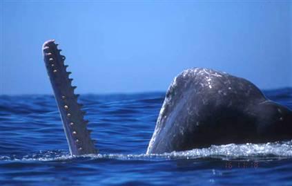
8 Whale Watch Dead whale


9 EcoCast Predicting fishery bycatch for management Predicted catch + Predicted bycatch EcoCast Using satellite data, areas optimized for fish catch and minimal bycatch can be predicted in near-real time for use by managers and fishers. Currently a RShiny app is under development. A NASA funded project. Elliott Hazen et al., NMFS/SWFSC


10 Salmon Survival in 2011 Adult Chinook Returns What happened in 2011? May 2008 May 2009 Forecasted return Observed return May 2010 May May 2012 May Time series of average April-May chlorophyll concentrations in coastal Gulf of Alaska. The lowest value (2011) suggests that low productivity could have negatively influenced salmon survival that year. Brian Burke Fish Ecology Division NWFSC, NOAA Fisheries

11 NRT Cruise support VIIRS chl image generated by NESDIS in support of a SEFSC survey cruise looking for bluefin tuna larvae. Images are used to position stations to cover frontal features, small and mesoscale oceanographic features, and to ensure as many different water masses as possible are sampled. They requested the images in gray scale. 2015/5/20 19:21-19:25 UTC (orig) John Lamkin, NOAA/NMFS/SEFSC

12 NRT Cruise support VIIRS chl image generated by NESDIS in support of a SEFSC survey cruise looking for bluefin tuna larvae. Images are used to position stations to cover frontal features, small and mesoscale oceanographic features, and to ensure as many different water masses as possible are sampled. They requested the images in gray scale. 2015/5/20 19:21-19:25 UTC (color) John Lamkin, NOAA/NMFS/SEFSC


13 HAB Operational Forecast System: Gulf of Mexico Karenia brevis Padre Island National Seashore Closes Park to Dogs (December 9, 2009) NOAA Coastal Ocean Science Forecast, Stone lab, July 07, 2016

14 Lake Eire cyanobacteria bloom, annual peak biomass: MERIS , MODIS NOAA Coastal Ocean Science Forecast, Stone lab, July 07, 2016


15 Ocean Data Assimilation (Navy Coupled Ocean Data Assimilation: NCODA) Hae-Cheol Kim, NWS/NCEP VIIRS NRT Ocean Color (K dpar, Chl-a)
 course aimed at NMFS or NOS participants (the wet side of NOAA) who want to learn how to access & use satellite data Objective is to help people access and use satellite data in the environment")
16 NOAA Ocean Satellite Course Aug 22-24, 2017 UW, Seattle, WA 3-day (free!) course aimed at NMFS or NOS participants (the wet side of NOAA) who want to learn how to access & use satellite data Objective is to help people access and use satellite data in the environment they are used to working in a challenging task! Focus has been on GIS, Matlab and R applications. Participants bring projects to work on. Course initiated by funding from NOAA s R&O project in The JPSS program has provided full or partial funding since The learning experience goes two ways. From conducting these courses we get a better idea of users needs and wants, and therefor are better able to address those needs.
17 Take Home Points Within NMFS, NOS and NWS, ocean color data is used in a variety of different applications, many of which are not a NRT or 24/7 usage. Examples include: Predicting and Monitoring HABs (NOS) Characterizing sanctuaries and MPA (NOS) Optimizing assessment surveys (NMFS) Improving Stock Assessments (NMFS) Characterizing Animal Habitat (NMFS) Dynamic Ocean Management (NMFS) Modeling & Data Assimilation (NWS) The biggest value of VIIRS is that it is part of a longer time-series of satellite chlorophyll measurements that extends back to Long-term climate-quality VIIRS ocean color data are needed for NMFS and NOS applications.


18 Thanks! Obrigada!
HAB Forecaster. For info on HABs in the Pacific Northwest see:
 HAB Forecaster BACKGROUND In this activity, students can take on the role as a resource manager or scientist, tasked with deciding if razor clam harvesters should go out onto the beach to harvest razor
53 contributors for 35 individual reports in 2009 show 5% of figures today
 A Group Approach to Understanding Ecosystem Dynamics in the Northeast Pacific Ocean William Crawford and James Irvine, Fisheries and Oceans Canada (DFO) * * * 53 contributors for 35 individual reports
Automated ocean color product validation for the Southern California Bight
 Automated ocean color product validation for the Southern California Bight Curtiss O. Davis a, Nicholas Tufillaro a, Burt Jones b, and Robert Arnone c a College of Earth, Ocean and Atmospheric Sciences,
Harmful Algal Blooms (HABs) 5 Applications
 5 Applications") Harmful Algal Blooms (HABs) 5 Applications Richard P. Stumpf NOAA, National Ocean Service HAB occurrences worldwide Image from whoi.edu/redtide HAB applications: short term Management: Monitoring and Response
Harmful Algal Blooms (HABs) 5 Applications Richard P. Stumpf NOAA, National Ocean Service HAB occurrences worldwide Image from whoi.edu/redtide HAB applications: short term Management: Monitoring and Response
Data Management for Algal Monitoring in the Gulf of Mexico
 Data Management for Algal Monitoring in the Gulf of Mexico Scott Cross NOAA National Oceanographic Data Center/ Coastal Data Development Center (NCDDC) Outline History Current & Future Directions Needs
Near-Real Time SNPP VIIRS Ocean Color Products from NOAA Okeanos Operational Production System
 Near-Real Time SNPP VIIRS Ocean Color Products from NOAA Okeanos Operational Production System Dr. Banghua Yan* NOAA Ocean Color Operational Product Area Lead NOAA/NESDIS/OSPO/Satellite Products Branch
OCEANOGRAPHIC DATA MANAGEMENT
 OCEANOGRAPHIC DATA MANAGEMENT Presented to: Environmental Disaster Data Management Meeting Russ Beard Director, National Coastal Data Development Center Interim Science Coordinator, Gulf Restoration Council
Egypt-NOAA Cooperation: Advancing our Environmental Science, Technology, and Education
 Egypt-NOAA Cooperation: Advancing our Environmental Science, Technology, and Education T. G. Onsager NOAA Space Weather Prediction Center and NWS International Activities Office (one-year detail) Terry.Onsager@noaa.gov
Operational Estuarine & Coastal Forecast Systems in NOAA s. National Ocean Service
 Operational Estuarine & Coastal Forecast Systems in NOAA s. National Ocean Service Eugene Wei, Frank Aikman III and Richard Patchen NOAA S S National Ocean Service Workshop on: Data Assimilation in Support
Distributional changes of west coast species and impacts of climate change on species and species groups
 Distributional changes of west coast species and impacts of climate change on species and species groups Elliott Hazen 1 Ole Shelton 2 Eric Ward 2 1 NOAA Southwest Fisheries Science Center 2 NOAA Northwest
Southern Florida to Cape Hatteras Spring Season Preview 2018 UPDATE ON U.S. EAST COAST GULF STREAM CONDITIONS
 Southern Florida to Cape Hatteras Spring Season Preview 2018 UPDATE ON U.S. EAST COAST GULF STREAM CONDITIONS By ROFFS Gregory J. Gawlikowski ROFFS continues its spring preview series by providing an overall
Evolution of NOAA s Observing System Integrated Analysis (NOSIA)
") Evolution of NOAA s Observing System Integrated Analysis (NOSIA) Presented to the 13th Symposium on Societal Applications: Policy, Research and Practice (paper 9.1) Louis Cantrell Jr., and D. Helms, R.
Evolution of NOAA s Observing System Integrated Analysis (NOSIA) Presented to the 13th Symposium on Societal Applications: Policy, Research and Practice (paper 9.1) Louis Cantrell Jr., and D. Helms, R.
Multivariate time-series forecasting of the NE Arabian Sea Oil Sardine fishery using satellite covariates
 Multivariate time-series forecasting of the NE Arabian Sea Oil Sardine fishery using satellite covariates Eli Holmes 1, Nimit Kumar 2, Sourav Maity 2, B.R Smitha 3, Sherine Cubelio 3, Cara Wilson 4, Narayanane
Summary of 2013 Activities
 Summary of 2013 Activities Name Affiliation Focus Area Frank Aikman NOAA-NOS Physical Cort Cooper, Chair Chevron Physical Dale Crockett Texas Water Development Board Coastal phys. Shejun Fan Shell (Formerly
Forecasting inshore red tide blooms using recent past offshore conditions on the West Florida Shelf
 Forecasting inshore red tide blooms using recent past offshore conditions on the West Florida Shelf Harford 1, Bill, Rykowski 2, MB, Babcock 2 EA, Karnauskas 3, M, Sagarese 3, SR, Walter 3, JF. (1) Cooperative
MERSEA Marine Environment and Security for the European Area
 MERSEA Marine Environment and Security for the European Area Development of a European system for operational monitoring and forecasting of the ocean physics, biogeochemistry, and ecosystems, on global
Add NOAA nowcoast Layers to Maps
 WebEOC Maps Add-on Quick Reference Guide Add NOAA nowcoast Layers to Maps Overview With Maps Add-on, you can configure an unlimited number of map layers. These layers allow you to control the data you
COVERAGE-Sargasso Sea
 COVERAGE-Sargasso Sea A Collaborative Project between NASA and the Sargasso Sea Commission Dr. Vardis Tsontos Dr. Jorge Vazquez NASA Jet Propulsion Laboratory, California Institute of Technology UN-HQ
Observing System Requirements for the Harmful Algal Bloom Forecast System in the Gulf of Mexico
 Observing System Requirements for the Harmful Algal Bloom Forecast System in the Gulf of Mexico July 2007 Background The Harmful Algal Bloom (HAB) Forecast System provides nowcasts and forecasts of Karenia
R. Michael Laurs 1, David G. Foley 2, and Michael Musyl 2. RML Fisheries Oceanographer Consultant, LLC, Jacksonville, OR USA
 Update on Research Regarding Identification and Utilization Of Habitats by Large Pacific Sharks Using PSAT Archival Tags, Oceanic Satellite Remote Sensing, and SODA Ocean Assimilation Model Analyses R.
Seasonal forecasting as a stepping stone to climate adaptation in marine fisheries and aquaculture
 Seasonal forecasting as a stepping stone to climate adaptation in marine fisheries and aquaculture Alistair Hobday Paige Eveson Jason Hartog Claire Spillman Projected changes (e.g. distribution) 11 species
NOAA Update and Key Issues Dr. Stephen Volz, Assistant Administrator for Satellite and Information Services
 NOAA Update and Key Issues Dr. Stephen Volz, Assistant Administrator for Satellite and Information Services Space Studies Board Meeting April 28, 2016 NOAA Satellite and Information Service Outline NOAA
Introduction to Ocean Numerical Modeling #0 General Introduction. Global model SSH regional model SST
 Introduction to Ocean Numerical Modeling #0 General Introduction Global model SSH regional model SST Gildas Cambon, IRD/LOPS, France gildas.cambon@ird.fr Global model SSH WEEK 1 regional model SST Day
NOAA/OAR Observing Systems
 NOAA/OAR Observing Systems Dr. Christopher L. Sabine Director NOAA s Pacific Marine Environmental Laboratory Workshop on Hydroclimate Monitoring Systems and Measurement Needs June, 2014 Global Ocean Observing
Satellite-derived environmental drivers for top predator hotspots
 Satellite-derived environmental drivers for top predator hotspots Peter Miller @PeterM654 South West Marine Ecosystems 2017 21 Apr. 2017, Plymouth University Satellite environmental drivers for hotspots
2017 ESRI CANADA GIS SCHOLARSHIP REPORT CURRENT POLLUTION PROBLEMS IN THE OCEANS
 MAY 31, 2017 2017 ESRI CANADA GIS SCHOLARSHIP REPORT CURRENT POLLUTION PROBLEMS IN THE OCEANS HASSAAN RAFIQUE BACHELOR OF APPLIED TECHNOLOGY GEOGRAPHIC INFORMATION SYSTEMS SOUTHERN ALBERTA INSTITUTE OF
NOAA Operational Forecast System Gulf of Mexico, Demonstration since Sep 1999; Operational since Sep 2004:
 NOAA Operational Forecast System Gulf of Mexico, Demonstration since Sep 1999; Operational since Sep 2004: An Operational forecast of impact: 0-3 days and a prediction of likelihood of a bloom for mgmt
Environmental forcing on forage fish and apex predators in the California Current: Results from a fully coupled ecosystem model
 Environmental forcing on forage fish and apex predators in the California Current: Results from a fully coupled ecosystem model Jerome Fiechter Institute of Marine Sciences, UC Santa Cruz Co-authors: K.
Observation system for early warning of HAB events
 Observation system for early warning of HAB events Vera L. Trainer, NOAA Fisheries Northwest Fisheries Science Center Marine Biotoxins Program Seattle, Washington, USA Juan de Fuca eddy Regional HAB OOS
The Emerging SIBER Initiative of IMBER/IOGOOS: Biogeochemical Observing Programs and Modeling Needs in the Indian Ocean
 The Emerging SIBER Initiative of IMBER/IOGOOS: Biogeochemical Observing Programs and Modeling Needs in the Indian Ocean Raleigh R. Hood (chair), Lynnath E. Beckley and S. Wajih A. Naqvi GSSC-XII Workshop,
NOAA s Big Data Project: Vision and Approach
 NOAA s Big Data Project: Vision and Approach Andy Bailey, BDP Technical Lead NOAA Office of the Chief Information Officer What is NOAA? United States Government Agency NOAA ~ National Oceanic and Atmospheric
NOAA S Arctic Program in 2017
 NOAA S Arctic Program in 2017 NOAA s Arctic Mission To determine how the Arctic system is changing on time scales of weeks to decades, particularly with respect to the consequences that the loss of sea
Gulf of Mexico Early Season Preview 2018 PROMISING FISHING CONDITIONS IN GULF OF MEXICO
 Gulf of Mexico Early Season Preview 2018 PROMISING FISHING CONDITIONS IN GULF OF MEXICO By Daniel C. Westhaver and Matthew A. Upton Introduction As in previous years, ROFFS is providing an early spring
Use of in-situ and remote sensors, sampling, and systems for assessing extent, fate, impact, and mitigation of oil and dispersants
 Use of in-situ and remote sensors, sampling, and systems for assessing extent, fate, impact, and mitigation of oil and dispersants Gustavo Jorge Goni (NOAA/AOML, Miami, FL) Gustavo.Goni@noaa.gov and the
Ocean currents from altimetry
 Ocean currents from altimetry Pierre-Yves LE TRAON - CLS - Space Oceanography Division Gamble Workshop - Stavanger,, May 2003 Introduction Today: information mainly comes from in situ measurements ocean
Impact of Climate Change on Chinook Salmon
 Region: Western Coastlines Grade Level(s): 5-8 Impact of Climate Change on Chinook Salmon Time Required: 2-3 class periods Focus Question(s): How will long term climate changes impact northwest Pacific
Increased phytoplankton blooms detected by ocean color
 Increased phytoplankton blooms detected by ocean color Mati Kahru & B. Greg Mitchell Scripps Institution of Oceanography/ University of California San Diego La Jolla, CA 92093-0218 ASLO Aquatic Sciences
Northeast U.S. Early Season Preview 2017 FISHING ACTION STARTING TO WARM UP ALREADY WITH LOTS OF FISH EXPECTED IN MAY
 Northeast U.S. Early Season Preview 2017 FISHING ACTION STARTING TO WARM UP ALREADY WITH LOTS OF FISH EXPECTED IN MAY By Matthew A. Upton and Mitchell A. Roffer ROFFS concludes its 2017 spring preview
Population Dynamics of Gulf Blue Crabs. Caz Taylor & Erin Grey Department of Ecology & Evolutionary Biology Tulane University
 Population Dynamics of Gulf Blue Crabs Caz Taylor & Erin Grey Department of Ecology & Evolutionary Biology Tulane University Blue Crab Callinectes sapidus Economically important in the Atlantic and the
The Relation between the Red Tide Occurrence and the Sea Water Temperature in South Sea of Korea
 , pp.132-136 http://dx.doi.org/10.14257/astl.2017.145.26 The Relation between the Red Tide Occurrence and the Sea Water Temperature in South Sea of Korea Do-Hyun Hwang 1, Su-Ho Bak 1, Heung-Min Kim 1,
Access to IOOS Data Relevant to OOI. Kathleen Bailey NOAA/NOS/IOOS January 6, 2016
 Access to IOOS Data Relevant to OOI Kathleen Bailey NOAA/NOS/IOOS January 6, 2016 The U.S. Integrated Ocean Observing System (IOOS) Federal Regional Satellites 600+: Buoys, Water Level stations, Coastal
C M E M S O c e a n C o l o u r S a t e l l i t e P r o d u c t s
 Implemented by C M E M S O c e a n C o l o u r S a t e l l i t e P r o d u c t s This slideshow gives an overview of the CMEMS Ocean Colour Satellite Products Marine LEVEL1 For Beginners- Slides have been
Hurricane Season 2010 & NOAA s Deepwater Response
 Hurricane Season 2010 & NOAA s Deepwater Response What s Happened? What Will 2010 Bring? Possible Shoreline Effects Darin Figurskey Meteorologist-in-Charge NOAA s NWS Raleigh, NC NOAA s National Weather
The Coastal Ocean Applications and Science Team (COAST): Science Support for a Geostationary Ocean Color Imager for Coastal Waters
: Science Support for a Geostationary Ocean Color Imager for Coastal Waters") The Coastal Ocean Applications and Science Team (COAST): Science Support for a Geostationary Ocean Color Imager for Coastal Waters PIs: Curt Davis and Mark Abbott NOAA Technical Contact: Paul Menzel, NOAA/STAR.
The Coastal Ocean Applications and Science Team (COAST): Science Support for a Geostationary Ocean Color Imager for Coastal Waters PIs: Curt Davis and Mark Abbott NOAA Technical Contact: Paul Menzel, NOAA/STAR.
CLIMAR-III Third JCOMM Workshop on Advances in Marine Climatology 6-9 May Gdynia, Poland
 CLIMAR-III Third JCOMM Workshop on Advances in Marine Climatology 6-9 May 2008. Gdynia, Poland Catherine Marzin Historical Ecology Program Manager National Marine Sanctuary Program Stefan Claesson Research
THE PORTUGUESE INSTITUTE FOR THE OCEAN AND ATMOSPHERE. Pedro Viterbo
 THE PORTUGUESE INSTITUTE FOR THE OCEAN AND ATMOSPHERE Pedro Viterbo pedro.viterbo@ipma.pt 2012 IPMA CREATION Before Now IM INRB/IPIMAR LNEG IPMA SOME NUMBERS: 506 Staff: Personnel 426 Budget 2014 11% 26%
Southern Florida to Cape Hatteras Early Season Preview 2017 U.S. EAST COAST GULF STREAM CONDITIONS LOOKING PROMISING
 Southern Florida to Cape Hatteras Early Season Preview 2017 U.S. EAST COAST GULF STREAM CONDITIONS LOOKING PROMISING By Matthew A. Upton and Mitchell A. Roffer ROFFS continues its spring preview series
RESEARCH REPORT SERIES
 GREAT AUSTRALIAN BIGHT RESEARCH PROGRAM RESEARCH REPORT SERIES Regional Availability of MODIS Imagery in the Great Australian Bight Ana Redondo Rodriguez1 Edward King2 and Mark Doubell1 SARDI Aquatic Sciences
NCODA Implementation with re-layerization
 NCODA Implementation with re-layerization HeeSook Kang CIMAS/RSMAS/U. Miami with W. Carlisle Thacker NOAA/AOML HYCOM meeting December 6 2005 1 GULF OF MEXICO MODEL CONFIGURATION: Horizontal grid: 1/12
Report Benefits and Challenges of Geostationary Ocean Colour Remote Sensing - Science and Applications. Antonio Mannino & Maria Tzortziou
 Report Benefits and Challenges of Geostationary Ocean Colour Remote Sensing - Science and Applications Antonio Mannino & Maria Tzortziou Time & Space Scales of OC Relevant Missions GOCI I & II Geo from
Gulf of Mexico Harmful Algal Bloom Bulletin. Region: Southwest Florida. Conditions Report. Additional Resources
 Gulf of Mexico Harmful Algal Bloom Bulletin Thursday, August 30, 2018 NOAA National Ocean Service NOAA Satellite and Information Service NOAA National Weather Service Instructions for viewing this geospatial
2001 State of the Ocean: Chemical and Biological Oceanographic Conditions in the Newfoundland Region
 Stock Status Report G2-2 (2) 1 State of the Ocean: Chemical and Biological Oceanographic Conditions in the Background The Altantic Zone Monitoring Program (AZMP) was implemented in 1998 with the aim of
Use of Ocean Observations to Develop Forecasts in Support of Fisheries Management
 Use of Ocean Observations to Develop Forecasts in Support of Fisheries Management Phillip R. Mundy Alaska Fisheries Science Center Juneau, Alaska Danielle F. Evenson Alaska Department of Fish and Game
HY-2A Satellite User s Guide
 National Satellite Ocean Application Service 2013-5-16 Document Change Record Revision Date Changed Pages/Paragraphs Edit Description i Contents 1 Introduction to HY-2 Satellite... 1 2 HY-2 satellite data
CICESE Update. S. G. Marinone Edgar G. Pavia. January 2017
 CICESE Update S. G. Marinone Edgar G. Pavia SCCOOS BOG Meeting Ca San Pedro, January 217 Outline/Highlights 1. Transboundary fisheries and biological migrations 2. Marginal Sea and MPA (Gulf of California)
an accessible interface to marine environmental data Russell Moffitt
 an accessible interface to marine environmental data Russell Moffitt The Atlas Project GOAL: To provide a single point of access to oceanographic and environmental data for use by marine resource researchers,
NOAA Arctic Priorities and Potential Contributions to PPP/YOPP. Randall Dole NOAA Earth System Research Laboratory Physical Sciences Division
 NOAA Arctic Priorities and Potential Contributions to PPP/YOPP Randall Dole NOAA Earth System Research Laboratory Physical Sciences Division 1 NOAA s Arctic Goals Forecast Sea Ice Strengthen Foundational
GREEN Grog : Global Reanalysis of Ocean. biogeochemistry :
 Colloque LEFE Clermont-Ferrand, 28-30 mars 2018 GREEN Grog : Global Reanalysis of Ocean biogeochemistry : Isabelle Dadou (LEGOS) Marion Gehlen (IPSL/LSCE) marion.gehlen@lsce.ipsl.fr and the GREEN Grog
NOAA Great Lakes CoastWatch Program
 Great Lakes Workshop Series on Remote Sensing of Water Quality May 7-8, 2014 NOAA GLERL, 4840 South State Rd, Ann Arbor, MI NOAA Great Lakes CoastWatch Program CoastWatch is a nationwide National Oceanic
JIMAR PFRP ANNUAL REPORT FOR FY 2007
 JIMAR PFRP ANNUAL REPORT FOR FY 2007 P.I. John Sibert Project Title: Integrative modeling in support of the Pelagic Fisheries Research Program: spatially disaggregated population dynamics models for pelagic
HYSPLIT volcanic ash dispersion modeling R&D, NOAA NWS NCEP operations, and transfer to operations
 HYSPLIT volcanic ash dispersion modeling R&D, NOAA NWS NCEP operations, and transfer to operations Barbara Stunder 1, Alice Crawford 1,2, Tianfeng Chai 1,2, Michael Pavolonis 3 1 NOAA OAR Air Resources
Synthesis and Integrated Modeling of Long-term Data Sets to Support Fisheries and Hypoxia Management in the Northern Gulf of Mexico
 Synthesis and Integrated Modeling of Long-term Data Sets to Support Fisheries and Hypoxia Management in the Northern Gulf of Mexico Dan Obenour (Scientific/Hypoxia PI) Kevin Craig (Applications/Fisheries
Increased phytoplankton blooms detected by ocean color
 Increased phytoplankton blooms detected by ocean color Mati Kahru & B. Greg Mitchell Scripps Institution of Oceanography/ University of California San Diego La Jolla, CA 92093-0218 ASLO Aquatic Sciences
Chapter 14: Primary Producers
 Chapter 14: Primary Producers Ernst Haeckel diatoms Diatom drawings by Ernst Haeckel Diatom art under a microscope slide 1 Images from Puget Sound: M. Guannel/H. van Tol 2 Images from Puget Sound: M. Guannel/H.
Post-Graduation Plans stock assessment scientist (NOAA, hopefully)
") Update Report Period 3/1/2013-2/28/2014 Project E/I-20 - NMFS Population Dynamics Sea Grant Graduate Fellowship An evaluation of the stock assessment method for eastern Bering Sea snow crab incorporating
Update Report Period 3/1/2013-2/28/2014 Project E/I-20 - NMFS Population Dynamics Sea Grant Graduate Fellowship An evaluation of the stock assessment method for eastern Bering Sea snow crab incorporating
What Maintains the Western Gulf of Maine Cod Stock?
 What Maintains the Western Gulf of Maine Cod Stock? James Churchill Woods Hole Oceanographic Inst.; Woods Hole MA, jchurchill@whoi.edu, Jeffrey Runge School of Marine Sciences, University of Maine, Gulf
Marine Spatial Planning: A Tool for Implementing Ecosystem-Based Management
 Marine Spatial Planning: A Tool for Implementing Ecosystem-Based Management Steven Murawski, Ph.D., Ecosystem Goal Team Lead National Oceanic and Atmospheric Administration NOAA November 16, 2009 1 To
Developing a nearshore geospatial framework for recovery assessment and planning
 Western Washington University Western CEDAR Salish Sea Ecosystem Conference 2018 Salish Sea Ecosystem Conference (Seattle, Wash.) Apr 6th, 10:30 AM - 10:45 AM Developing a nearshore geospatial framework
Copernicus Marine Environment Monitoring Service
 Copernicus Marine Environment Monitoring Service Mercator Ocean March 2017 Implemented by Entrusted to Mercator Ocean by the European Commission Cliquez et modifiez le titre French non-profit company Owned
The National Weather Service of the Future: Building a Weather-Ready Nation
 The of the Future: Building a Weather-Ready Nation Dr. Louis W. Uccellini Director, NOAA Assistant Administrator for Weather Services NCEP Production Suite Review December 2, 2014 Outline Building a Weather-Ready
water cycle evaporation condensation the process where water vapor the cycle in which Earth's water moves through the environment
 cycle a series of events that happen over and over water cycle evaporation the cycle in which Earth's water moves through the environment process when the heat of the sun changes water on Earth s surface
- Global Reanalysis of Ocean biogeochemistry : GREEN Grog -
 Journées GMMC Toulon, 7-9 juin 2016 - Global Reanalysis of Ocean biogeochemistry : - Marion Gehlen (IPSL/LSCE) marion.gehlen@lsce.ipsl.fr and the consortium A new PPR associating : Mercator-Océan CLS,
EDUCATION PROGRAMS GUIDE
 EDUCATION PROGRAMS GUIDE Inner Space Center University of Rhode Island Graduate School of Oceanography innerspacecenter.org ABOUT THE ISC The Inner Space Center (ISC) is an international leader in ocean
Great Lakes Information Network GIS (Queryable by topic, geography, organization, and upload date 73 layers as of October, 2009)
") Google Earth Files for the Great Lakes and Beyond GLOS Mapping Workshop Alpena, Michigan November 9, 2009 David Hart GIS Specialist University of Wisconsin Sea Grant Institute GREAT LAKES Great Lakes Information
Google Earth Files for the Great Lakes and Beyond GLOS Mapping Workshop Alpena, Michigan November 9, 2009 David Hart GIS Specialist University of Wisconsin Sea Grant Institute GREAT LAKES Great Lakes Information
Integrating climate forecasting tools into predictive models of marine mammal distribution
 Integrating climate forecasting tools into predictive models of marine mammal distribution Elizabeth Becker 1, Dave Foley 1, 2, Karin Forney 1, Jay Barlow 1 1 NOAA Fisheries, Southwest Fisheries Science
Figure 14 p.385 5/11/2016. Plankton Production and Food Webs. Plankton Production and Food Webs
 Plankton Production and Food Webs (Chapter 12) What is Plankton? Phytoplankton and Zooplankton Food Web: All the feeding relationships of a community including production, consumption, decomposition and
Capturing a Holistic Understanding of a Large Marine Ecosystem The NOAA Gulf of Mexico Data Atlas
 Capturing a Holistic Understanding of a Large Marine Ecosystem The NOAA Gulf of Mexico Data Atlas NODC / National Coastal Data Development Center gulfalas.noaa.gov Need: data that contribute to long-term
National Marine Sanctuary Program
 National Marine Sanctuary Program NMSP/USGS Joint Seabed Mapping Initiative: September 2004 AA National Ocean Service National Marine Sanctuaries Interim Report September 2004 Background: Since 2002,
NOAA Satellite & Information Service (NESDIS)
") Transition from Research to Operation for GNSS Radio Occultation Abigail D. Harper National Environmental Satellite, Data, and Information Service (NESDIS) Deputy Assistant Administrator, Systems April
Transition from Research to Operation for GNSS Radio Occultation Abigail D. Harper National Environmental Satellite, Data, and Information Service (NESDIS) Deputy Assistant Administrator, Systems April
Movements of striped bass in response to extreme weather events
 Movements of striped bass in response to extreme weather events Helen Bailey and David Secor E-mail: hbailey@umces.edu 1 Background 2 Outline What is movement ecology? Methods for analyzing animal tracks
Updated Stock Status Indicators for Silky Sharks in the Eastern Pacific Ocean (Document SAC 06 08b)
") Updated Stock Status Indicators for Silky Sharks in the Eastern Pacific Ocean (Document SAC 06 08b) A. Aires da Silva, C. Lennert Cody, M. N. Maunder, M. Román Verdesoto and M. G. Hinton Comisión Interamericana
Updated Stock Status Indicators for Silky Sharks in the Eastern Pacific Ocean (Document SAC 06 08b) A. Aires da Silva, C. Lennert Cody, M. N. Maunder, M. Román Verdesoto and M. G. Hinton Comisión Interamericana
Adjoint-based parameter estimation for the spatially explicit model of large pelagics (with application to skipjack tuna).
.") Inna Senina 1, John Sibert 1 and Patrick Lehodey 2 Adjoint-based parameter estimation for the spatially explicit model of large pelagics (with application to skipjack tuna). 1 Pelagic Fisheries Research
Inna Senina 1, John Sibert 1 and Patrick Lehodey 2 Adjoint-based parameter estimation for the spatially explicit model of large pelagics (with application to skipjack tuna). 1 Pelagic Fisheries Research
Biogeochemical modelling and data assimilation: status in Australia
 Biogeochemical modelling and data assimilation: status in Australia Richard Matear, Andrew Lenton, Matt Chamberlain, Mathieu Mongin, Emlyn Jones, Mark Baird www.cmar.csiro.au/staff/oke/ Biogeochemical
Organisms fill various energy roles in an ecosystem. Organisms can be producers, consumers, or decomposers
 Organisms fill various energy roles in an ecosystem An organism s energy role is determined by how it obtains energy and how it interacts with the other living things in its ecosystem Organisms can be
Background Field program information Examples of measurements Wind validation for synthetic modeling effort
 Background Field program information Examples of measurements Wind validation for synthetic modeling effort How do complex fine-scale structure and processes in coastal waters dominated by pulsed-river
Yi Chao Jet Propulsion Laboratory California Institute of Technology & Joint Institute for Regional Earth System Science and Engineering (JIFRESSE)
") Strategy to Develop a 3D Ocean Circulation Forecasting System for Cook Inlet Yi Chao Jet Propulsion Laboratory California Institute of Technology & Joint Institute for Regional Earth System Science and
Strategy to Develop a 3D Ocean Circulation Forecasting System for Cook Inlet Yi Chao Jet Propulsion Laboratory California Institute of Technology & Joint Institute for Regional Earth System Science and
Priority Conservation Areas: Baja California to Bering Sea
 Priority Conservation Areas: Baja California to Bering Sea Lance Morgan, Chief Scientist Marine Conservation Biology Institute Goal : Identify Unique Places How do you start conservation planning for an
Altimetry for Coastal Applications. Paul M. DiGiacomo and Amanda Bittinger NOAA CoastWatchatch Program 5 February 2008
 Altimetry for Coastal Applications Paul M. DiGiacomo and Amanda Bittinger NOAA CoastWatchatch Program 5 February 2008 IGOS COASTAL THEME REPORT Published January 2006, IOC http://www.igospartners.org/d
HIGH RESOLUTION RAPID REFRESH COUPLED WITH SMOKE (HRRR- SMOKE): REAL-TIME AIR QUALITY MODELING SYSTEM AND ITS APPLICATION TO CASE STUDIES
: REAL-TIME AIR QUALITY MODELING SYSTEM AND ITS APPLICATION TO CASE STUDIES") HIGH RESOLUTION RAPID REFRESH COUPLED WITH SMOKE (HRRR- SMOKE): REAL-TIME AIR QUALITY MODELING SYSTEM AND ITS APPLICATION TO CASE STUDIES Ravan Ahmadov 1,2 (ravan.ahmadov@noaa.gov) Acknowledgement: G.
HIGH RESOLUTION RAPID REFRESH COUPLED WITH SMOKE (HRRR- SMOKE): REAL-TIME AIR QUALITY MODELING SYSTEM AND ITS APPLICATION TO CASE STUDIES Ravan Ahmadov 1,2 (ravan.ahmadov@noaa.gov) Acknowledgement: G.
Factors impacting the formation & modification of sinking oil snow : Processes and Pathways
 Factors impacting the formation & modification of sinking oil snow : Processes and Pathways K.L. Daly 1, U. Passow 2, C. Hu 1, N. Prouty 3, F. Mienis 4,A. Remsen 1, K. Kramer 1, and S. Murasko 5 1 University
cycle water cycle evaporation condensation the process where water vapor a series of events that happen over and over
 cycle a series of events that happen over and over water cycle evaporation the cycle in which Earth's water moves through the environment process when the heat of the sun changes water on Earth s surface
Naturally. Westport... Wet and Wild...
 Westport... Wet and Wild... Naturally A revitalization concept for the City of Westport and Port of Grays Harbor presented by FOGH (Friends of Grays Harbor), Wildlife Forever of Grays Harbor and other
Regional Environmental Conditions & Impacts Coordination. NOAA West May 25, 2016
 Regional Environmental Conditions & Impacts Coordination NOAA West May 25, 2016 1 Call Agenda Welcome El Niño and Regional Climate brief (D. McEvoy) Climatology Application (NANOOS) Environmental conditions
JPSS GEONETCAST REQUIREMENTS DISCUSSION
 Joint Polar Satellite System (JPSS) JPSS GEONETCAST REQUIREMENTS DISCUSSION Mitch Goldberg Program Scientist Joint Polar Satellite System National Environmental Satellite, Data, and Information Service
What Lives in the Open Ocean and Where Do They Live?
 Open Ocean 2 Concepts What are some of the organisms in the ocean? How do the physical (abiotic) properties of the ocean define what organisms live there? Standards Addressed HCPS 5.1, 5.2, & 5.3 Duration
Multi-sensor Improved Sea-Surface Temperature (MISST) for IOOS Navy component
 for IOOS Navy component") DISTRIBUTION STATEMENT A. Approved for public release; distribution is unlimited. Multi-sensor Improved Sea-Surface Temperature (MISST) for IOOS Navy component Charlie N. Barron NRL Code 7321 Stennis Space
DISTRIBUTION STATEMENT A. Approved for public release; distribution is unlimited. Multi-sensor Improved Sea-Surface Temperature (MISST) for IOOS Navy component Charlie N. Barron NRL Code 7321 Stennis Space
Seasonal Climate Watch September 2018 to January 2019
 Seasonal Climate Watch September 2018 to January 2019 Date issued: Aug 31, 2018 1. Overview The El Niño-Southern Oscillation (ENSO) is still in a neutral phase and is still expected to rise towards an
Oct.23,2014. PICES2014,Yeosu
 PICES2014,Yeosu Oct.23,2014 A multi-model ensemble prediction of habitat suitability index (HSI) models for neon flying squid in central North Pacific by using 3-D ocean data assimilation product Hiromichi
SW Florida Escarpment Mapping Area
 Overview NOAA s Okeanos Explorer (EX) Program plans to conduct systematic mapping and telepresence-enabled ROV explorations in the Gulf of Mexico during Spring 2014. In 2011, the EX conducted mapping operations
Introduction: The Gulf of Mexico Alliance. The Gulf GAME project MERMAid and PHINS Results & Conclusions What s next? Examples
 AAG Las Vegas March 25, 2009 Introduction: Ocean governance and Ecosystem-Based Management The Gulf of Mexico Alliance Habitat Identification and Characterization The Gulf GAME project MERMAid and PHINS