Appendix C. Pleasure Lake Emergency Action Plan
|
|
|
- Ginger Parsons
- 5 years ago
- Views:
Transcription
1 Appendix C Pleasure Lake Emergency Action Plan
2

3 EMERGENCY ACTION PLAN PLEASURE LAKE DAM NYS ID DAM NO NAT DAM ID NO. NY00345 SULLIVAN COUNTY NEW YORK SUBMITTED TO: FALLSBURG FISHING AND BOATING CLUB SULLIVAN COUNTY, NEW YORK PAUL C. RIZZO ASSOCIATES, INC. NEW YORK REGION 580 WHITE PLAINS ROAD SUITE 425 TARRYTOWN, NEW YORK USA PROJECT NO JUNE 2008

4 Mr. Peter Connery, P.E. New York State Department of Environmental Conservation Dam Safety Section, 4 th Floor 625 Broadway Albany, New York TRANSMITTAL EMERGENCY ACTION PLAN PLEASURE LAKE DAM STATE DAM ID# TOWN OF FALLSBURG SULLIVAN COUNTY, NEW YORK June 13, 2008 Project No Dear Mr. Connery: Transmitted herewith are three (3) copies of the revised Emergency Action Plan for the Pleasure Lake Dam. The Plan has been reviewed and updated to reflect the Department s July 31, 2007, review comments. Our responses to these comments are presented in this letter. To facilitate your review, NYSDEC comments are presented in bold-faced type and our responses are presented in regular type. Draft EAP Comments COMMENT NO. 5: Cover page Add the State Dam ID # ( ) and the National Dam ID number (NY00345). sheet. RESPONSE NO. 5: The dam identification numbers have been added to the cover COMMENT NO. 6: Section 1.0 Is the same notification flow chart to be use for all three emergency scenarios? Note that this scenarios are more typically referred to as Condition A, B or C. Using common terminology may be less confusing to emergency responders that may also be involved with other dams and EAPs. RESPONSE NO. 6: The notification flow chart title box has been modified to indicate that the chart applies to all three condition classifications. In addition, the condition classifications descriptions in Section 4 have been changed to reflect the more typical alphabetic designations. L /08
5 Mr. Peter Connery 2 June 13, 2008 COMMENT NO. 7: Notification Flow Chart Make it clear that the Club s first call should be the County EMC. In the upper DEC box, delete the words Bureau of Flood Protection and substitute therefore Dam Safety Section. Also, Alon Dominitz should be listed first as the primary contact, with Joe Albert listed second as the backup. DEC only needs to be listed once on the flow chart, so consider deleting the lower box from the County EMC to DEC. RESPONSE NO. 7: The requested changes have been made to the notification flow chart. COMMENT NO. 8: Section 3 Figure No. 1 should be labeled Figure 3-1. In the last sentence on page 3, is the following intended: has a Reservoir volume at normal pool of less than 1000 acre-feet? RESPONSE NO. 8: The figure was previously corrected in the distribution sets and the suggested wording revisions have been incorporated in the text. COMMENT NO. 9: Section 4, Section 4.1, 1 st paragraph, second sentence, add the concept of unusual conditions with the dam. In Section 4.3.3, 1 st sentence, consider adding the words a condition when there is a situation of concern, such a flooding, but there is no danger of Dam failure. The 2 nd sentence seems redundant. RESPONSE NO. 9: We have added the concept of unusual conditions with the dam including examples to Section 4.1 and we have deleted the redundant sentence. COMMENT NO. 10: Section 5.1, 2 nd paragraph. Refer to Appendix B, which correctly states that EAPs should be reviewed and/or updated at least annually. RESPONSE NO. 10: Reference to Appendix B has been added to Section 5.1. COMMENT NO. 11: Section 5.3. A list of downstream residents should be included (perhaps in an Appendix for ease of future updates?), with contact information, organized in the specified order of notification from upstream to downstream. Consider dividing the list according to the sides of the stream, perhaps with separate teams responsible for notifications and evacuations for each side. Evacuation routes and collection centers should be identified, mapped and described. RESPONSE NO. 11: Reference to a list of downstream residents has been added to Section 1.0 and the list of downstream residents has been added to Appendix D. Since all the residences are group in a very small area it does not seem necessary to group them by location. Evacuation routes have identified and described in Section 7.0. Figure 7-2 is showing evacuation routes, suggested collection areas, and road block locations have been added to the Plan. L /08
6 Mr. Peter Connery 3 June 13, 2008 COMMENT NO. 12: Section 6. It s acceptable to refer to the discussion of the availability /location of emergency supplies listed in the I&M Plan, but note that the I&M Plan does not discuss over aspects of preparedness such as backup communications or any enhanced monitoring. It is implied in the flow chart that land lines are considered the primary means of communication, with cell phones as backup (and then perhaps radios?), but perhaps these (and any others, as appropriate) should be considered further and more explicitly discussed herein. Enhanced monitoring (i.e. more frequent, over and above that discussed in the I&M Plan) would be appropriate when an emergency condition is declared, especially during weekends, holidays, nights and inclement weather; perhaps with the increment of monitoring increasing as the emergency condition rating increases. RESPONSE NO. 12: The descriptions have been modified as suggested. COMMENT NO. 13: Figure 7-1, Note 3 refers to dam break plus base flood. Does base flood equal to 100 year event, or the ½ PMF event? Also, has the inundation analysis been extended far enough downstream? Analysis should extent until the incremental rise between the non break and the dam break condition for each scenario is 2 feet or less. RESPONSE NO. 13: The base flood is the Spillway Design Flood (SDF) for the Project which was selected by incremental analysis of the basin as submitted in the March, 2003, Hydrologic and Hydraulic Evaluation. The SDF for Pleasure Lake Dam is 0.4 PMF. Based on RIZZO's analysis as presented in the March, 2003, Report, a dam break under a 0.4 PMF condition causes a 0.1 foot increase in flood elevation at Thompsonville (see Table 3-7). The calculated water level at the confluence of Sheldrake Creek and the Neversink River due to a sunny day dam break is approximately El There are three structures immediately downstream that may have some level of flooding. We suggest that these structures be investigated and if they are residences, they should be included in an updated version of the notification list. COMMENT NO. 14: Include a designated list of plan holders to facilitate distribution of future revisions and updates, and for the coordination of training and exercises. RESPONSE NO. 14: A designated list of Plan holders has been added to Appendix E of the Plan. Please note that we have relocated our New York Area office. I can be reached at (914) , extension 401. Very truly yours, Paul C. Rizzo Associates, Inc. Hans Hasnay, P.E. Project Manager AHH/dc/crb/lsm cc: Fallsburg Fishing and Boating Club L /08
7 TABLE OF CONTENTS PAGE LIST OF FIGURES... iii 1.0 NOTIFICATION FLOWCHART STATEMENT OF PURPOSE PROJECT DESCRIPTION EMERGENCY DETECTION, EVALUATION, AND CLASSIFICATION DETECTION OF AN EMERGENCY CONDITION EVALUATION OF AN EMERGENCY CONDITION CLASSIFICATION OF THE DAM FAILURE CONDITION Condition Classification A Condition Classification B Condition Classification C GENERAL RESPONSIBILITIES UNDER THE EAP GENERAL RESPONSIBILITIES Fallsburg Fishing and Boating Club Responsibilities Responsibility for Notification of Emergency Condition to State and Local Officials Responsibility for Evacuation of Downstream Areas Responsibility for Duration, Security, Termination, and Follow-Up Evaluations of the EAP EAP Coordinator Responsibility PREPAREDNESS DAM SURVEILLANCE AND MONITORING PROGRAM INUNDATION MAP DAM BREAK ANALYSIS EMERGENCY ACTION PLAN REVIEWS AGENCY REVIEW AND APPROVAL...15 R /08 i
8 TABLE OF CONTENTS (CONTINUED) REFERENCES FIGURES APPENDIX A DAM BREAK ANALYSIS APPENDIX B EMERGENCY ACTION PLAN REVIEWS (NOT INCLUDED) APPENDIX C AGENCY REVIEW AND APPROVAL (NOT INCLUDED) APPENDIX D ORGANIZATIONAL FLOW CHART AND LIST OF DOWNSTREAM RESIDENTS APPENDIX E PLAN DISTRIBUTION LIST R /08 ii
9 LIST OF FIGURES FIGURE NO. FIGURE 3-1 FIGURE 3-2 FIGURE 7-1 FIGURE 7-2 TITLE SITE LOCATION MAP WATERSHED PLAN DAM BREAK INUNDATION MAP EMERGENCY ACTION PLAN R /08 iii
10
11 EMERGENCY ACTION PLAN PLEASURE LAKE DAM SULLIVAN COUNTY, NEW YORK 1.0 NOTIFICATION FLOWCHART The flowchart for a Dam failure condition will summarize the individuals to be notified and the responsibility for and priority of such notification in the event of a Dam failure emergency. Potential Dam failure conditions are further defined in Section 4.0. The Notification Flowchart and a list of the downstream residents to be contacted can be found in Appendix D. R /08
12 2 2.0 STATEMENT OF PURPOSE The purpose of this Emergency Action Plan (EAP) is to define responsibilities and provide procedures that are designed to notify the appropriate Emergency Management Personnel and other public safety officials of a possible, impending, or actual failure of Pleasure Lake Dam. R /08
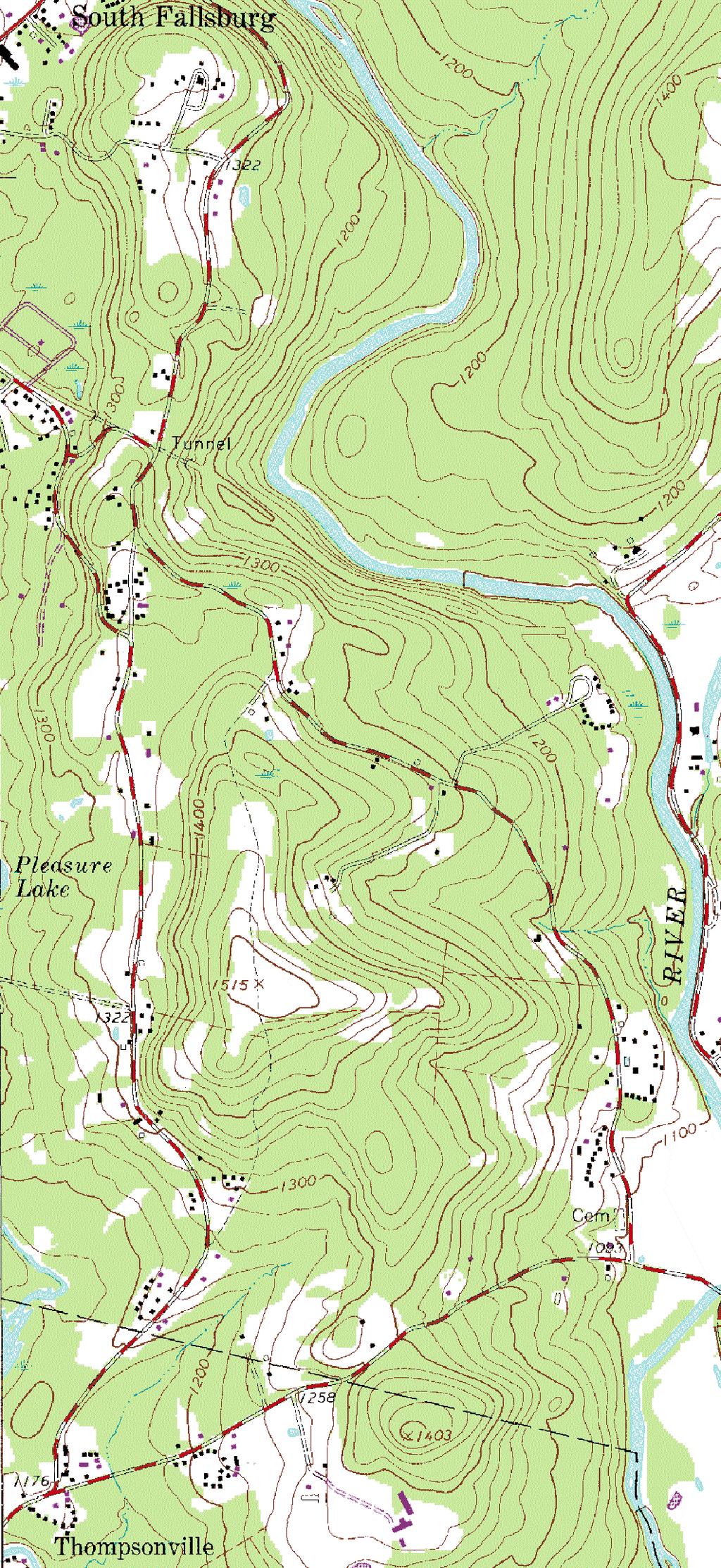
13 3 3.0 PROJECT DESCRIPTION Pleasure Lake Dam is located on the southern end of the Pleasure Lake on the Sheldrake Stream, a tributary of the Neversink River, located in Sullivan County, New York. It is owned and operated by the Fallsburg Fishing and Boating Club (CLUB). A Site Location Map is provided as Figure 3-1. The Pleasure Lake Dam is an earthfill embankment with a masonry gravity dam section along the downstream slope. The dam is less than 40 feet high and has a reservoir volume at normal pool of less than 1,000 acre-feet. The dam is approximately 470 feet long with a crest width that varies from 17 to 34 feet. The upstream slope of the earthfill has a one horizontal to one vertical (1H:1V) slope. The Emergency Spillway is 25 feet long and 35 feet wide at the crest. It is cut into the east abutment of the embankment. The Emergency Spillway has a 250-foot-long trapezoidal channel with a bottom width of approximately 21 feet and side slopes of 4H:1V. The exit slope is approximately 20H:1V. A single lane gravel roadway on the Dam Crest provides access to lakeside homes. Roadway traffic crosses a steel and wood bridge spanning two sluiceways and a spillway near the center of the dam. Two 4-foot-long sluiceways are located adjacent to an auxiliary spillway at the maximum dam section. The sluiceway walls are fitted with stoplog guides. Stoplogs are used to control the lake level and regulate flow from the reservoir. The Pleasure Lake Watershed is approximately 13.6 square miles in area and land use consists of the small towns of Loch Sheldrake, South Fallsburg, undeveloped wooded areas, farmland, rural homesteads, and a golf course. Undeveloped wooded areas comprise more than half of the total watershed area. The Pleasure Lake Watershed Plan is shown on Figure 3-2. Downstream areas that would be inundated in the event of a dam failure are located downstream of the Thompsonville-Sheldrake (Ranch Road) Bridge where there is a concentration of occupied dwellings. This bridge is located approximately one (1) mile from the dam. Based on the results of the dam break modeling, a catastrophic failure of the dam, either during sunny day or flood event conditions, could result in the loss of property or life. R /08
14 4 4.0 EMERGENCY DETECTION, EVALUATION, AND CLASSIFICATION This section presents the procedures for the timely detection, evaluation, and classification of an existing or potential emergency condition at Pleasure Lake Dam. 4.1 DETECTION OF AN EMERGENCY CONDITION The early detection of an emergency condition at Pleasure Lake Dam and the evaluation of information are a critical component to the EAP. The CLUB operations and/or maintenance personnel that observe unusual conditions with the dam such as signs of slope movements, depressions, sinkholes, sand boils, cracking of concrete surfaces, discharges, abnormal reservoir levels, or water overtopping the dam, should immediately report the conditions to the CLUBS s Dam Safety Official. The Dam Safety Official will analyze the incoming information and will determine if an emergency situation exists. The following list provides examples of discharges or reservoir levels that indicate if an abnormal condition exists at Pleasure Lake Dam. The examples are a partial listing of a dam emergency situation and in no means depict all potential emergency conditions of the Site. Example 1: Unusual rise in surface elevations downstream of the dam. An unusual rise in downstream waters could be an indication of a breach or piping dam failure. The spillway should be checked to see if the rise in downstream water levels is explained by an increase in water discharged over the spillway. Example 2: Water seepage at the dam, especially at the toe of the embankment. Any water that seeps through the dam, whether fast or slow moving, can indicate a potential piping dam failure. If the water source cannot be explained (such as water discharges by a toe drain), or if the water is murky or cloudy with sediment, an emergency condition may be imminent. Example 3: A high water reservoir elevation at Pleasure Lake. A water surface elevation within two feet from the top of the dam and rising would indicate that dam overtopping is possible. R /08
15 5 Example 4: An earthquake event. A slump or shift in the embankment alignment, a sinkhole, movement of the spillway, or other unusual depression/movement could indicate a potential dam failure emergency. The detection of an emergency condition may also be obtained from state, county, or town officials, and the general public. Once notification of an unusual condition is received by the CLUB from an external source, the CLUB will assess the data and determine if an emergency should be declared. 4.2 EVALUATION OF AN EMERGENCY CONDITION When the CLUB receives notification of a potential emergency condition at Pleasure Lake Dam, the Dam Safety Official must evaluate the data and determine if an emergency condition should be declared. Input from real-time observations at the dam, discussions with the CLUB s maintenance personnel and weather forecasts will be needed in the evaluation process. The evaluation of emergency conditions should consider the safety of the general public. The evaluation should be timely and on the side of caution. After the evaluation, a classification of the dam failure condition will be made. 4.3 Classification of the Dam Failure Condition Following the evaluation of the emergency condition, one of three classifications can be declared: Condition Classification A This classification is called a Dam Failure Warning which indicates a condition when dam failure is imminent or has occurred. Generally this situation is a condition where time has run out with respect to the failure of the dam. This is a situation where a failure has occurred, is occurring, or is about to occur. Once the CLUB has determined there is no longer any time available to attempt corrective measures to prevent dam failure, this warning should be issued and the emergency notification process should begin. R /08
16 6 Emergency management agencies should interpret a Dam Failure Warning Alert as notification that the dam is failing and immediately implement evacuation and road closure procedures. The CLUB will establish a command center on-site and assign a team of maintenance and engineering personnel who will be responsible for coordinating emergency action procedures, provide assistance to emergency management agencies, and, if possible, implement dam hazard reduction procedures Condition Classification B This classification is called a Dam Failure Watch which indicates a condition when a potentially hazardous dam situation is developing. Generally, a watch situation is a condition that some amount of time is available for further analyses to be made before dam failure is considered a foregone conclusion. This is a situation where a failure may eventually occur but pre-planned actions taken during certain events (e.g., major floods, earthquakes, evidence of piping) may moderate or alleviate failure. Even if failure is inevitable, more time is generally available in a Watch Condition than in a Warning Condition to issue warnings and/or take preparedness actions. The CLUB will establish a command center on-site and assign a team of maintenance and engineer personnel to implement steps for the reduction or the elimination of the hazard potential. Periodic status Reports will be provided to the Emergency Management Personnel and local authorities. The authorities will decide on the appropriate course of action. Because of the proximity of the residences near the Thompsonville-Sheldrake (Ranch Road) Bridge, this road should be closed and resident evacuation should be strongly considered. Emergency Management Agencies should interpret a Dam Failure Watch as a condition that requires constant evaluation to determine what action is needed to prevent injury or damage in the event of the dam failure Condition Classification C This classification is called a Non Failure Emergency which indicates a condition. When there is a situation of concern, such as flooding, but there is no danger of dam failure. R /08
17 7 The CLUB will continue to monitor the situation at the dam, and will have the option to notify the appropriate agencies of the situation. Appropriate agencies to contact may include highway departments and public safety personnel. R /08
18
19 8 5.0 GENERAL RESPONSIBILITIES UNDER THE EAP This section will specify the people and organizations responsible for the maintenance and operation of the dam and persons or groups responsible for implementing various phases of the EAP. 5.1 GENERAL RESPONSIBILITIES Fallsburg Fishing and Boating Club Responsibilities As Owner, the CLUB is responsible for the maintenance and operation of the Pleasure Lake Dam. CLUB personnel will review the EAP on a regular basis to ensure that the Plan is up-to-date and that all personnel involved in the Plan are familiar with their duties and responsibilities. Such personnel are to be advised of the importance of a thorough understanding of the Plan. Documentation of the EAP review will be included in Appendix B of future revisions. When initiating the EAP, CLUB personnel will clearly state that the Emergency Action Plan for Pleasure Lake Dam is now being initiated. They will briefly define what section will be implemented in the EAP (Dam Failure Warning or Dam Failure Watch) and if applicable, the portion of the dam that has failed or will fail, and the time of failure. An example of what may be said during a Dam Failure Warning is: This is (name of personnel) from Fallsburg Fishing and Boating Club calling to initiate the Emergency Action Plan for Pleasure Lake Dam. It is (time of call) and the (portion of the Dam) has failed. Please refer to the Dam Failure Warning Alert procedures described in your copy of the Emergency Action Plan for Pleasure Lake Dam and take appropriate action to notify the agencies/organizations under your jurisdiction and implement your own Emergency Plans. R /08
20 9 After making the necessary notifications, CLUB personnel will establish a command center onsite and assign a team of personnel to implement steps for the reduction or the elimination of the hazard potential Responsibility for Notification of Emergency Condition to State and Local Officials The CLUB will normally be the party responsible for notifying the Sullivan County Office of Emergency Management (SCOEM) of an emergency situation at Pleasure Lake Dam. SCOEM will be responsible for notifying the appropriate New York state and local officials (e.g., New York State Police, Town of Thompson) of an emergency situation at Pleasure Lake Dam. However, such notification may also be provided by the CLUB, or other party. The responsibility of these authorized personnel is the same under both Condition A Dam Failure Warning Alert (failure is imminent or has occurred) and Condition B Dam Failure Watch Alert (potential failure is developing) Responsibility for Evacuation of Downstream Areas The notification and evacuation of the downstream area is normally the responsibility of the Sullivan County Office of Emergency Management Office (SCOEM). The SCOEM will notify local police to dispatch personnel to the downstream residences. The SCOEM will also telephone the residences and notify them of the emergency declaration Responsibility for Duration, Security, Termination, and Follow-Up Evaluations of the EAP The CLUB is responsible for the on-site monitoring of the situation at the dam and will keep local authorities informed of developing conditions from the time the emergency starts until the emergency has been terminated. The CLUB and local law enforcement officials will secure the area immediately adjacent to the dam to keep the public from entering an unsafe area. The CLUB will coordinate with local authorities when determining that the emergency situation is to be terminated. Following implementation of the Emergency Action Plan for Pleasure Lake Dam, the CLUB will prepare a follow-up evaluation of the Plan. This evaluation should have critical input from the R /08
21 10 SCOEM and other officials involved in the Plan for recommendations on changes, additions, or deletions needed to improve the Plan EAP Coordinator Responsibility Emergency Action Plan related activities will be coordinated by the Club Dam Safety Chairman. The coordinator will be responsible for preparing and distributing revisions to the Plan, establishing training seminars, and coordinating EAP exercises. The coordinator will also act as the contact point for involved parties that have questions or comments about the Plan. The current coordinator for the CLUB is Mr. William Voegelin. He can be reached at R /08
22 PREPAREDNESS 6.1 DAM SURVEILLANCE AND MONITORING PROGRAM The normal Dam Surveillance and Monitoring Program for the Pleasure Lake Dam is fully described in the Pleasure Lake Inspection, Operation, and Maintenance Plan. The Plan addresses the action to be taken during a Non Failure Emergency flooding event. During a Dam Failure Warning or Dam Failure Watch event (Condition Classification A or B) the dam is to be monitored from a safe location throughout the event. Personnel monitoring the dam should use either land line telephones or mobile telephones to maintain communications. It is anticipated that emergency responders will use dedicated radio frequencies to communicate with the Sullivan County Emergency Control Center. If the event does not result in a dam failure, the CLUB s professional engineer should fully inspect the dam to verify it is safe to resume normal operation. R /08
23 INUNDATION MAP The Pleasure Lake Dam Break Inundation Map is shown on Figure 7-1. This map shows the areas that would potentially be flooded by a dam failure. Note that the inundation limits portrayed on this map are approximate and should be used for emergency planning only. Two failure events are shown on the inundation map. The red area shows the result of a sunny day dam break. This type of failure is one in which a normal, non-flooding stream flow exists before the dam failure. A sunny day failure is often considered to be more dangerous to the general public in that people don t expect such a significant and rapid rise in water elevation. People may be fishing or wading in the downstream area prior to the sunny day failure. The blue area shows the results of a flood situation dam break. This is often considered less dangerous to the downstream area since people are not likely to be utilizing the stream area during flooding conditions. The red and blue areas on the map illustrate those areas that will be flooded with a dam failure during high flow of 0.5 PMF. The inundation map was prepared using USGS quadrangle mapping. Water surface elevations were marked at the key cross-section locations and were interpolated for areas between the crosssections. The inundation map shows that both the towns of Fallsburg and Thompson will be affected by a dam break. It should be noted that the dam break analysis has been conducted for Pleasure Lake Dam does not imply that the dam is unstable or presents a safety concern to the public. Figure 7-2 shows recommended evacuation routes and road block locations in the Thompsonville area. R /08
24 DAM BREAK ANALYSIS A description of the dam break analyses performed to assess the flooding impact of catastrophic failure of the Pleasure Lake Dam is included in Appendix A. R /08
25 EMERGENCY ACTION PLAN REVIEWS Plan reviews will be held annually with all personnel who have designated responsibilities under this EAP. The reviews are to ascertain that the parties fully understand their responsibilities. Each time revisions are made to the Plan, the EAP will be re-distributed to the local agencies and company personnel who have responsibilities under this EAP. Those receiving revisions to the Plan will be requested to complete and sign a statement acknowledging receipt and understanding of the updated EAP. This document will be included in Appendix B. The EAP will be reviewed and updated as necessary and on an annual basis. The annual review of the EAP will include two actions. A review of the notification flow chart and proper tables and appendices will occur to verify that the telephone number and designated contacts are current. In addition, each agency of the notification flow chart will be contacted to review their responsibilities in the event of an emergency. Revision of the EAP should be distributed to the designated plan holders listed in Appendix E. R /08
26 AGENCY REVIEW AND APPROVAL The revised Plan will be submitted to the New York State Department of Environmental Conservation and the Sullivan County Emergency Control Center for review. Once a review has been conducted and approvals have been received, documentation of submittal and approval of the EAP by the responsible parties will be included in Appendix C. R /08
27 REFERENCES
28
29 REFERENCES Federal Energy Regulatory Commission (FERC), 1991, Engineering Guidelines for Evaluation of Hydropower Projects, Chapter III Gravity Dams, Federal Energy Regulatory Commission, Office of Hydropower Licensing, Report No. FERC , Washington DC, USA. National Weather Service, Simplified Dam Break (SMPDBK) computer program, NWS, Stetson-Harza, 1990, Phase II Hydrological/Hydraulic Investigation of Pleasure Lake Dam for the Fallsburg Fishing and Boating Club, Stetson-Harza, Utica, NY.
30
31 FIGURES
32

33
34

35
36
37 APPENDIX A DAM BREAK ANALYSIS
38
39 DAM BREAK ANALYSIS Dam break analyses were performed to assess the flooding impact of catastrophic failure of the Pleasure Lake Dam. The computer program Simplified Dam Break (NWS, 1991) was used to perform the analyses. The primary point of interest downstream is the Thompsonville-Sheldrake (Ranch Road) Bridge where there is a concentration of occupied dwellings; however, the entire stream valley to the confluence with the Neversink River was evaluated. The analyses consider both sunny day and flood event type dam failures. Input parameters include: Type of dam (earth); Reservoir stage-volume relationship; Reservoir volume (4,068 acre-feet); Reservoir area (206 acres); Reservoir level at time of failure (EL 1,214, one foot above crest); Dam breach elevation (EL 1,213); Average final breach width (90 feet); Breach bottom (EL 1,184); Time of dam failure (30 minutes); Non-breach flow at time of failure (4,700 cfs for flood event failure and 0 cfs for sunny day failure); and Downstream geometry and conditions. Reservoir volume, area, and elevation parameters are developed from the existing reservoir conditions. Dam break parameters (breach width, time of failure, and breach bottom) are selected based average recommended values published in federal dam evaluation guidelines (FERC, 1991). The trigger elevation was selected as one foot above the crest of the dam. The non-breach flow is selected as the flow at the Thompsonville-Sheldrake (Ranch Road) Bridge at the time of breach failure. A-1
40 Downstream geometry and conditions are selected based USGS topographic mapping, previous analyses (Stetson-Harza, 1990), and observed conditions. There are 21 downstream crosssections defined for the approximate 2.5-mile stretch of Sheldrake Stream to the confluence with Neversink Creek. The dam break model was run for both the sunny day failure and flood event failure conditions. At the downstream bridge, the peak dam break flood wave for the sunny day and flood event failures was estimated to be and , respectively. It was determined that the sunny day breach has a slightly higher floodplain elevation near the downstream point of interest and at points beyond, because during the flood event failure, water in the downstream channel provides energy dissipation and a quicker attenuation of the peak flood wave from the dam break. Based on the results of the dam break modeling, a catastrophic failure of the dam, either during sunny day or flood event conditions, could result in the loss of property or life. A-2
41 APPENDIX B EMERGENCY ACTION PLAN REVIEWS (NOT INCLUDED)
42
43 APPENDIX C AGENCY REVIEW AND APPROVAL (NOT INCLUDED)
44
45 APPENDIX D ORGANIZATIONAL FLOW CHART AND LIST OF DOWNSTREAM RESIDENTS
46
47 APPENDIX D Fallsburg Fishing and Boating Club Parties Responsible for Operations of the Dam Ronald Vance, President (845) William Voegelin, Dam Coordinator (845) (845) Jim Reynolds, Caretaker (845) (914) Mobile NEW YORK STATE DEPARTMENT OF ENVIROMENTAL CONSERVATION Dam Safety Section Alan Dominitz, Chief Dam Safety Section (518) Office (518) Mobile Joseph Albert, EAP Coordinator (518) Note: Pleasure Lake and its dam are located in the Town of Fallsburg. But any damaged caused by the dam failing would be in the Town of Thompson. Fallsburg Fishing and Boating Club PLEASURE LAKE DAM Thompsonville, New York Dam Break Emergency WARNING FLOW CHART FOR CONDITION CLASIFICATION A, B, & C FIRST CALL Sullivan County Emergency Control Center 911 Sullivan County Office of Emergency Management (845) Ext Town of Thompson SUPERVISOR (845) (845) Mobile HIGHWAY SUPERINTENDANT (845) New York State Police (845) DOWNSTREAM RESIDENTS See Attached List SULLIVAN COUNTY SHERIFF'S DEPARTMENT Michael Schiff, Sheriff (845) Sullivan County DPW (845) NEW YORK STATE DEPARTMENT OF TRANSPORTATION (845) NEW YORK STATE EMERGENCY COORDINATION CENTER Staffed 24 Hours (518) NATIONAL WEATHER SERVICE Binghamton, New York (607) Northeast River Forecast Center - Tauton, MA (508) R /08 Last Updated: July 1, 2007
48
49 DOWNSTREAM RESIDENTS LOT BLOCK OWNER TELEPHONE Gray / D Amico Francine (845) Ranch Road PO Box 60 Thompsonville, NY Sheldon P. Silverman (Eileen) (845) Ranch Road PO Box 6 Thompsonville, NY Natving Soloman Valerie Armand Breton 1057 Poplar Circle (845) Weston, FL Hinkley Rose Goetz PO Box 150 (845) Thompsonville, NY Kenneth Hopkins (845) Massive Marrin (845) PO Box 51 Thompsonville, NY Fernandez Juan (845) PO Box 221 Thompsonville, NY Last Updated: February 5, 2007
50
51 APPENDIX E PLAN DISTRIBUTION LIST
52
53 EMERGENCY ACTION PLAN PLEASURE LAKE DAM SULLIVAN COUNTY, NEW YORK. PLAN DISTRIBUTION LIST Town of Thompson, New York Supervisor Richard Martinkovic Town of Thompson, NY Highway Supervisor Office of Emergency Management Sullivan County Emergency Control Center Sullivan County Sheriff s Department Monticello, New York New York State Police Liberty, New York New York State Department of Environmental Conservation, Dam Safety Section, Albany, New York (3 copies)
54
Emergency Action Plan (EAP) Tata Pond Dam
 Tata Pond Dam") For Official Use Only Not for Public Distribution 02/03/16 Emergency Action Plan (EAP) Tata Pond Dam State of Connecticut Dam ID: 0000 Town or City, County, Connecticut Name of Dam Owner Dam Hazard Classification
For Official Use Only Not for Public Distribution 02/03/16 Emergency Action Plan (EAP) Tata Pond Dam State of Connecticut Dam ID: 0000 Town or City, County, Connecticut Name of Dam Owner Dam Hazard Classification
North Carolina Simplified Inundation Maps For Emergency Action Plans December 2010; revised September 2014; revised April 2015
 North Carolina Simplified Inundation Maps For Emergency Action Plans December 2010; revised September 2014; revised April 2015 INTRODUCTION Emergency Action Plans (EAPs) are critical to reducing the risks
Flood Scenario Worksheet
 Flood Scenario Worksheet Scenario adapted from: http://www.epa.gov/watersecurity/tools/trainingcd/simple/source/scenario-8/ssc8-0.pdf Simple Tabletop Exercise, Interdependency Natural Disaster Scenario,
Monitoring Scour Critical Bridges During Floods For Local Bridge Owners. Presented by
 Monitoring Scour Critical Bridges During Floods For Local Bridge Owners Presented by SAFETY FIRST DO NOT ENDANGER YOURSELF OR OTHERS WHILE MONITORING BRIDGES DO NOT ENTER FLOOD WATERS FLOOD WATERS INCLUDE
A Simple Procedure for Estimating Loss of Life from Dam Failure. Wayne J. Graham, P.E. 1
 A Simple Procedure for Estimating Loss of Life from Dam Failure Wayne J. Graham, P.E. 1 INTRODUCTION Evaluating the consequences resulting from a dam failure is an important and integral part of any dam
Emergency Action Plan
 EMERGENCY ACTION PLAN Emergency Action Plan Virginia Electric and Power Company Possum Point Power Station Inventory Number 153020 Ash Pond D Dam Dumfries, Virginia Submitted To: Dominion Energy 5000 Dominion
THE NEED FOR AN ADDITIONAL SPILLWAY AT THE SANFORD DAM BOILING SPRING LAKES, NC. Presentation for The Brunswick County Commissioners April 20, 2015
 THE NEED FOR AN ADDITIONAL SPILLWAY AT THE SANFORD DAM BOILING SPRING LAKES, NC Presentation for The Brunswick County Commissioners April 20, 2015 The Sanford Dam Earth Dam constructed in 1961 Drainage
VIRGINIA ELECTRIC AND POWER COMPANY CHESTERFIELD POWER STATION LOWER ASH POND CHESTERFIELD COUNTY, VIRGINIA
 Prepared for Dominion 5000 Dominion Boulevard Glen Allen, Virginia 23060 EMERGENCY ACTION PLAN VIRGINIA ELECTRIC AND POWER COMPANY CHESTERFIELD POWER STATION LOWER ASH POND CHESTERFIELD COUNTY, VIRGINIA
RESERVOIR DRAWDOWN RATES/RESERVOIR DRAWDOWN TEST Iron Gate, Copco (I & II), and JC Boyle Dams
, and JC Boyle Dams") TECHNICAL MEMORANDUM No. 1 TO: Michael Bowen California Coastal Conservancy Geotechnical & Earthquake Engineering Consultants CC: Eric Ginney Philip Williams & Associates PREPARED BY: Paul Grant SUBJECT:
TECHNICAL MEMORANDUM No. 1 TO: Michael Bowen California Coastal Conservancy Geotechnical & Earthquake Engineering Consultants CC: Eric Ginney Philip Williams & Associates PREPARED BY: Paul Grant SUBJECT:
President s Day Weekend Storm Community Meeting and Workshop April 17, 2017
 President s Day Weekend Storm Community Meeting and Workshop April 17, 2017 Meeting outline 1. Progress update on the City of San Jose s recovery efforts 2. Water district presentation on: Weather situation
Louisiana s NIKE Approach to EAPs: Just Do It
 Louisiana s NIKE Approach to EAPs: Presented to: Just Do It 2007 Louisiana Transportation Engineering Conference Navigating the Waves of Change Tuesday, February 13, 2007 Baton Rouge River Center Presented
PENNSYLVANIA DEPARTMENT OF TRANSPORTATION ENGINEERING DISTRICT 3-0
 PENNSYLVANIA DEPARTMENT OF TRANSPORTATION ENGINEERING DISTRICT 3-0 LYCOMING COUNTY S.R.15, SECTION C41 FINAL HYDROLOGIC AND HYDRAULIC REPORT STEAM VALLEY RUN STREAM RELOCATION DATE: June, 2006 REVISED:
COMMUNITY EMERGENCY RESPONSE TEAM FLOODS INTRODUCTION
 INTRODUCTION Floods are one of the most common hazards in the United States. A flood occurs any time a body of water rises to cover what is usually dry land. Flood effects can be local, impacting a neighborhood
U.S. ARMY CORPS OF ENGINEERS
 CORPS FACTS Regulating Mississippi River Navigation Pools U.S. ARMY CORPS OF ENGINEERS BUILDING STRONG Historical Background Federal improvements in the interest of navigation on the Mississippi River
The last three sections of the main body of this report consist of:
 Threatened and Endangered Species Geological Hazards Floodplains Cultural Resources Hazardous Materials A Cost Analysis section that provides comparative conceptual-level costs follows the Environmental
MUNICIPALITY OF ANCHORAGE PUBLIC TRANSPORTATION DEPARTMENT AnchorRIDES TRANSPORTATION SYSTEM
 Purpose: The Public Transportation Department and contracted provider will provide safe transportation for AnchorRIDES customers and employees during severe weather or emergency conditions. AnchorRIDES
LOMR SUBMITTAL LOWER NEHALEM RIVER TILLAMOOK COUNTY, OREGON
 LOMR SUBMITTAL LOWER NEHALEM RIVER TILLAMOOK COUNTY, OREGON Prepared for: TILLAMOOK COUNTY DEPARTMENT OF COMMUNITY DEVELOPMENT 1510-B THIRD STREET TILLAMOOK, OR 97141 Prepared by: 10300 SW GREENBURG ROAD,
UPPER COSUMNES RIVER FLOOD MAPPING
 UPPER COSUMNES RIVER FLOOD MAPPING DRAFT BASIC DATA NARRATIVE FLOOD INSURANCE STUDY SACRAMENTO COUTY, CALIFORNIA Community No. 060262 November 2008 Prepared By: CIVIL ENGINEERING SOLUTIONS, INC. 1325 Howe
Modeling Great Britain s Flood Defenses. Flood Defense in Great Britain. By Dr. Yizhong Qu
 Modeling Great Britain s Flood Defenses AIRCurrents Editor s note: AIR launched its Inland Flood Model for Great Britain in December 2008. The hazard module captures the physical processes of rainfall-runoff
Dunn County Snow Removal Policy
 Dunn County Snow Removal Policy OVERVIEW With the advent of another winter season in the northern plains comes the possibility of snow, freezing rain and slippery roadways, and area resident s concern
Floods. Floods COMMUNITY EMERGENCY RESPONSE TEAM FLOODS CONTENT INSTRUCTOR GUIDANCE
 Floods Floods Introduce this topic by explaining that floods are one of the most common hazards in the United States. A flood occurs any time a body of water rises to cover what is usually dry land. Display
INFLOW DESIGN FLOOD CONTROL SYSTEM PLAN 40 C.F.R. PART PLANT YATES ASH POND 2 (AP-2) GEORGIA POWER COMPANY
 GEORGIA POWER COMPANY") INFLOW DESIGN FLOOD CONTROL SYSTEM PLAN 40 C.F.R. PART 257.82 PLANT YATES ASH POND 2 (AP-2) GEORGIA POWER COMPANY EPA s Disposal of Coal Combustion Residuals from Electric Utilities Final Rule (40 C.F.R.
INFLOW DESIGN FLOOD CONTROL SYSTEM PLAN 40 C.F.R. PART 257.82 PLANT YATES ASH POND 2 (AP-2) GEORGIA POWER COMPANY EPA s Disposal of Coal Combustion Residuals from Electric Utilities Final Rule (40 C.F.R.
2014 San Gabriel Valley Water Forum. October 2, 2014
 2014 San Gabriel Valley Water Forum October 2, 2014 Panel 3 Are we Ready? Flooding, Fires and Earthquakes Don Boland, California Utilities Emergency Association Southern California Catastrophic Earthquake
WINTER STORM Annex II
 WINTER STORM Annex II I. PURPOSE A. This annex has been prepared to ensure a coordinated response by state agencies to requests from local jurisdictions to reduce potential loss of life and to ensure essential
CITY OF NEW LONDON WINTER ROAD & SIDEWALK MAINTENANCE POLICY
 CITY OF NEW LONDON WINTER ROAD & SIDEWALK MAINTENANCE POLICY GENERAL The purpose of this policy is to set up acceptable procedures and policies for the winter maintenance of public areas in the City of
Standard Operating Procedure
 Standard Operating Procedure Procedure: Emergency Weather Plan - Events Department/Division: Section: Date Originated: Culture & Recreation April 30, 2013 Approval: Approval: Date Revised: Reference: HUR130-016
MEDIA RELEASE FOR IMMEDIATE RELEASE March 17, 2014 Preparing for the Spring Thaw
 BRACEBRIDGE, ONT Springtime is fast approaching and flooding in low lying areas of the Town is a potential risk due to melting snow and spring rain fall. Flooding can also be experienced during extreme
United States Multi-Hazard Early Warning System
 United States Multi-Hazard Early Warning System Saving Lives Through Partnership Lynn Maximuk National Weather Service Director, Central Region Kansas City, Missouri America s s Weather Enterprise: Protecting
CITY OF EAST PEORIA SNOW AND ICE CONTROL PROGRAM INTRODUCTION
 CITY OF EAST PEORIA SNOW AND ICE CONTROL PROGRAM INTRODUCTION The responsibility for providing snow and ice control on East Peoria s 240 lane miles of streets and alleys rests with the Street Divisions
Limited Visual Dam Safety Inspections OA Oahu Reservoir No Oahu, Hawaii
 Limited Visual Dam Safety Inspections OA00137 Oahu Reservoir No. 155 Oahu, Hawaii Prepared by: U.S. ARMY CORPS OF ENGINEERS HONOLULU DISTRICT STATE OF HAWAII DEPARTMENT OF LAND AND NATURAL RESOURCES May
COPPER MOUNTAIN MINE TAILINGS MANAGEMENT FACILITY DAM BREACH INUNDATION STUDY REVISION 1. Submitted to: Copper Mountain Mine (BC) Ltd.
 Ltd.") AMEC Environment & Infrastructure a Division of AMEC Americas Limited Suite 600 4445 Lougheed Highway, Burnaby, BC Canada V5C 0E4 Tel +1 (604) 294-3811 Fax +1 (604) 294-4664 wwwameccom COPPER MOUNTAIN
AMEC Environment & Infrastructure a Division of AMEC Americas Limited Suite 600 4445 Lougheed Highway, Burnaby, BC Canada V5C 0E4 Tel +1 (604) 294-3811 Fax +1 (604) 294-4664 wwwameccom COPPER MOUNTAIN
LOMR SUBMITTAL LOWER NESTUCCA RIVER TILLAMOOK COUNTY, OREGON
 LOMR SUBMITTAL LOWER NESTUCCA RIVER TILLAMOOK COUNTY, OREGON Prepared for: TILLAMOOK COUNTY DEPARTMENT OF COMMUNITY DEVELOPMENT 1510-B THIRD STREET TILLAMOOK, OR 97141 Prepared by: 10300 SW GREENBURG ROAD,
EMERGENCY WARNING SYSTEM PROCEDURES FOR DEBRIS FLOWS IN WESTERN OREGON
 EMERGENCY WARNING SYSTEM PROCEDURES FOR DEBRIS FLOWS IN WESTERN OREGON Updated: 12/03/2007 by the Oregon Department of Forestry and the Oregon Department of Geology and Mineral Industries Debris flows
Emergency Action Guidelines for NH 4-H Animal Events
 Emergency Action Guidelines for NH 4-H Animal Events Purpose: This plan outlines guidelines designed to help ensure NH 4-H Animal Events and Shows are prepared for emergencies and severe weather conditions.
HISTORY OF CONSTRUCTION FOR EXISTING CCR SURFACE IMPOUNDMENT PLANT GASTON ASH POND 40 CFR (c)(1)(i) (xii)
(1)(i) (xii)") HISTORY OF CONSTRUCTION FOR EXISTING CCR SURFACE IMPOUNDMENT PLANT GASTON ASH POND 40 CFR 257.73(c)(1)(i) (xii) (i) Site Name and Ownership Information: Site Name: E.C. Gaston Steam Plant Site Location:
HISTORY OF CONSTRUCTION FOR EXISTING CCR SURFACE IMPOUNDMENT PLANT GASTON ASH POND 40 CFR 257.73(c)(1)(i) (xii) (i) Site Name and Ownership Information: Site Name: E.C. Gaston Steam Plant Site Location:
YELLOWSTONE RIVER FLOOD STUDY REPORT TEXT
 YELLOWSTONE RIVER FLOOD STUDY REPORT TEXT TECHNICAL REPORT Prepared for: City of Livingston 411 East Callender Livingston, MT 59047 Prepared by: Clear Creek Hydrology, Inc. 1627 West Main Street, #294
IOWA COUNTY ORDINANCE NO. 22 IOWA COUNTY SNOW & ICE POLICY
 IOWA COUNTY ORDINANCE NO. 22 IOWA COUNTY SNOW & ICE POLICY AN ORDINANCE REPEALING ESTABLISHING THE POLICY AND LEVEL OF SERVICE IN RESPECT TO CLEARANCE OF SNOW AND ICE AND MAINTENANCE OF IOWA COUNTY S SECONDARY
Resolution Number: (2) Resolution Title: Snow Policy Date Signed: 11/26/12. DAVIS COUNTY Snow Policy Resolution
 Resolution Title: Snow Policy Date Signed: 11/26/12. DAVIS COUNTY Snow Policy Resolution") Resolution Number: 112612(2) Resolution Title: Snow Policy Signed: 11/26/12 DAVIS COUNTY Snow Policy Resolution A RESOLUTION TO ESTABLISH THE POLICY AND LEVEL OF SERVICE IN RESPECT TO CLEARANCE OF SNOW
Resolution Number: 112612(2) Resolution Title: Snow Policy Signed: 11/26/12 DAVIS COUNTY Snow Policy Resolution A RESOLUTION TO ESTABLISH THE POLICY AND LEVEL OF SERVICE IN RESPECT TO CLEARANCE OF SNOW
City of Saginaw Right of Way Division Snow and Ice Removal Policy January 18, 2016
 Snow and Ice Removal Policy January 18, 2016 It is the policy of the to provide snowplowing and ice removal services in order to: Provide safe traveling conditions for motorists and pedestrians Assist
PUBLIC SAFETY POWER SHUTOFF POLICIES AND PROCEDURES
 PACIFIC GAS AND ELECTRIC COMPANY PUBLIC SAFETY POWER SHUTOFF POLICIES AND PROCEDURES SEPTEMBER 2018 1 PACIFIC GAS AND ELECTRIC COMPANY PUBLIC SAFETY POWER SHUTOFF POLICIES AND PROCEDURES SEPTEMBER 2018
Tornado Drill Exercise Plan (EXPLAN)
") Tornado Drill Exercise Plan (EXPLAN) As part of the National Weather Service s (NWS) Severe Weather Preparedness Week in Indiana Purdue University March 19, 2019 As of Feb 19, 2019 TABLE OF CONTENTS Introduction...
Tornado Drill Exercise Plan (EXPLAN) As part of the National Weather Service s (NWS) Severe Weather Preparedness Week in Indiana Purdue University March 19, 2019 As of Feb 19, 2019 TABLE OF CONTENTS Introduction...
Annex B Natural No-Notice Event
 Annex B Natural No-Notice Event Version: 1.0 Effective: 10/01/2015 Revision Date: 10/01/2015 Approved By: John Pitcher Purpose The purpose of Natural No-Notice Event Annex is to ensure the safety of BHCC
CCR Rule Annual Inspection Report (cont.) 2
 2") The inspection findings consisted of maintenance items and items that were not observed to be signs or potential signs of significant structural weakness. No deficiencies or disrupting conditions that
The inspection findings consisted of maintenance items and items that were not observed to be signs or potential signs of significant structural weakness. No deficiencies or disrupting conditions that
DRAFT - Tsunami Response Plan Playbook Santa Cruz Harbor Maritime Community
 DRAFT - Tsunami Response Plan Playbook Santa Cruz Harbor Maritime Community Page 1 Best to display on 11X17 paper Purpose and Use of this Real-time Tsunami Response Plan Playbook PURPOSE: This product
City of Punta Gorda Community Emergency Management Plan 2013
 City of Punta Gorda Community Emergency Management Plan 2013 Hurricane Andrew- August 24, 1992 Category 5 hurricane. The second-most-destructive hurricane in U.S. history. The first named storm of the
Tippecanoe County ARES Net Formats NET 1-4. Net Formats
 1. Introduction Net Formats To provide a basis for carrying out the mission of the Tippecanoe County, Indiana, Amateur Radio Emergency Service (ARES ), guidelines must be in place to meet the communications
Information Reception: Decision Support Standards: Public Notification Plan: Protection Program: Education:
 The National Weather Service (NWS) has implemented a voluntary recognition program to help large outdoor venues, including those on university campuses, better protect staff and patrons from the dangers
ANALYSIS OF THE 2010 AMERICAN SHAD RADIO TELEMETRY ANIMATIONS RSP 3.5 CONOWINGO HYDROELECTRIC PROJECT FERC PROJECT NUMBER 405
 ANALYSIS OF THE 2010 AMERICAN SHAD RADIO TELEMETRY ANIMATIONS RSP 3.5 CONOWINGO HYDROELECTRIC PROJECT FERC PROJECT NUMBER 405 Prepared for: Prepared by: Normandeau Associates, Inc. Gomez and Sullivan Engineers,
STRUCTURAL STABILITY ASSESSMENT
 STRUCTURAL STABILITY ASSESSMENT CFR 257.73(d) Bottom Ash Pond Complex Cardinal Plant Brilliant, Ohio October, 2016 Prepared for: Cardinal Operating Company Cardinal Plant Brilliant, Ohio Prepared by: Geotechnical
Table-Top Exercise for Emergency Preparedness Evaluation: Little Anse, Isle Madame
 Table-Top Exercise for Emergency Preparedness Evaluation: Little Anse, Isle Madame Alexander Chung, M.Sc. Candidate C-Change Student Research Associate May 2013 The Community of Little Anse Coastal community
Attachment B to Technical Memorandum No.2. Operations Plan of Ross Valley Detention Basins
 Attachment B to Technical Memorandum No.2 Operations Plan of Ross Valley Detention Basins Operations Plan of Ross Valley Detention Basins Stetson Engineers Inc. January 26, 2011 1.0 Introduction Achieving
The Leader in Landscape Solutions
 The Leader in Landscape Solutions Emergency Action Plan Hurricane Preparedness Go To Mainscape.com For More Information! Purpose: To provide the Federation at Kings Point and their residents an informative
Town of Barnstable. Department of Public Work. Snow and Ice Control Operations Plan
 Town of Barnstable Department of Public Work Snow and Ice Control Operations Plan I. Mission: The mission of the Department of Public Works is to remove accumulations of snow and ice from town, county
RESOLUTION NO INTRODUCTION
 RESOLUTION NO. 0824 A RESOLUTION TO ESTABLISH THIS CITY S SNOW AND ICE CONTROL POLICY DURING WINTER MONTHS, SPECIFICALLY DEFINED AS NOVEMBER THROUGH MARCH. BE IT RESOLVED BY THE CITY COUNCIL OF SOLON,
Interpretive Map Series 24
 Oregon Department of Geology and Mineral Industries Interpretive Map Series 24 Geologic Hazards, and Hazard Maps, and Future Damage Estimates for Six Counties in the Mid/Southern Willamette Valley Including
The City of Ottawa Flood Hazards
 The City of Ottawa Flood Hazards The City of Ottawa is located in North Central LaSalle County, approximately 45 miles West of Joliet and 90 miles South of Rockford. The primary water course and sources
Appendix E Guidance for Shallow Flooding Analyses and Mapping
 Appendix E Guidance for Shallow Flooding Analyses and Mapping E.1 Introduction Different types of shallow flooding commonly occur throughout the United States. Types of flows that result in shallow flooding
DE PUBLIC SERVICE COMPANY OF NEW HAMPSHIRE
 DE 05-142 PUBLIC SERVICE COMPANY OF NEW HAMPSHIRE Petition for License to Construct and Maintain Electric Lines Over and Across the Public Waters of the Nashua River in the City of Nashua, New Hampshire
PSEG Long Island LLC 111 Eighth Avenue, 13th Floor New York, NY 10011
 PSEG Long Island LLC 111 Eighth Avenue, 13th Floor New York, NY 10011 December 31, 2013 Mr. John D. McMahon Chief Operating Officer Long Island Lighting Company d/b/a/ LIPA 333 Earle Ovington Boulevard,
Lessons Learned and Shared
 Lessons Learned and Shared Plan for the worst. Hope for the best. Remember that hope is not a strategy. Agnes 8 Lessons 1. Identify Susceptible Communities 2. Develop a Plan 3. Threat Recognition 4. Review
Progress Report. Flood Hazard Mapping in Thailand
 Progress Report Flood Hazard Mapping in Thailand Prepared By: Mr. PAITOON NAKTAE Chief of Safety Standard sub-beuro Disaster Prevention beuro Department of Disaster Prevention and Mitigation THAILAND E-mail:
HISTORY OF CONSTRUCTION FOR EXISTING CCR SURFACE IMPOUNDMENT PLANT GADSDEN ASH POND 40 CFR (c)(1)(i)-(xii)
(1)(i)-(xii)") HISTORY OF CONSTRUCTION FOR EXISTING CCR SURFACE IMPOUNDMENT PLANT GADSDEN ASH POND 40 CFR 257.73(c)(1)(i)-(xii) (i) Site Name and Ownership Information: Site Name: Site Location: Site Address: Gadsden
HISTORY OF CONSTRUCTION FOR EXISTING CCR SURFACE IMPOUNDMENT PLANT GADSDEN ASH POND 40 CFR 257.73(c)(1)(i)-(xii) (i) Site Name and Ownership Information: Site Name: Site Location: Site Address: Gadsden
UNIVERSITY OF WISCONSIN-PARKSIDE TORNADO WARNINGS AND ALERT POLICY ADMINISTRATIVE POLICY NUMBER 39 TABLE OF CONTENTS
 UNIVERSITY OF WISCONSIN-PARKSIDE TORNADO WARNINGS AND ALERT POLICY ADMINISTRATIVE POLICY NUMBER 39 TABLE OF CONTENTS Page 1. PURPOSE 2 2. DEFINITIONS 2 3. GENERAL OVERVIEW 2 4. SPECIFIC PROCEDURES 3 4.1
FRIENDS OF THE EEL RIVER
 FRIENDS OF THE EEL RIVER Working for the recovery of our Wild & Scenic River, its fisheries and communities. Frank Blackett, Regional Engineer Office of Energy Projects Division of Dam Safety and Inspections
EXHIBIT H LOT 317 GRADING AND SITE PLAN
 EXHIBIT H LOT 317 GRADING AND SITE PLAN EXHIBIT I LOT 317 ELEVATIONS ridge height 4915'-6" GENERAL & KEYED NOTES ridge height 4905'-9" 3 7 4 A5.1 1 5 ridge height 4910'-6" 2 ridge height 4906'-3" 1 Provide
BOONE COUNTY Snow Removal Program and Policy SECTION 1, INTRODUCTION:
 BOONE COUNTY Snow Removal Program and Policy SECTION 1, INTRODUCTION: The Roads Department of Boone County is responsible for providing snow removal for approximately 1100 miles of county roads. The Roads
December 11, 2006 File:
 December 11, 2006 File: 15-85-38 Alberta Infrastructure and Transportation Room 301, Provincial Building 9621-96 Avenue Peace River, Alberta T8S 1T4 Attention: Mr. Ed Szmata PEACE REGION (SWAN HILLS AREA)
LOS ANGELES UNIFIED SCHOOL DISTRICT REFERENCE GUIDE
 TITLE: NUMBER: ISSUER: School Procedures During Inclement Weather Conditions REF-5706.2 Earl R. Perkins, Assistant Superintendent School Operations Thelma Meléndez de Santa Ana, Ph.D. Chief Executive Officer
OC Public Works El Niño Storm Preparation 2015
 OC Public Works El Niño Storm Preparation 2015 December 8, 2015 Overview About OC Public Works Storm Preparation Pre-Storm During Storm Post-Storm Storm Preparation Canyon and Burn Areas County Department
Flood Hazard Zone Modeling for Regulation Development
 Flood Hazard Zone Modeling for Regulation Development By Greg Lang and Jared Erickson Pierce County GIS June 2003 Abstract The desire to blend current digital information with government permitting procedures,
APPLICATION FOR CONDITIONAL ABSOLUTE WATER STORAGE RIGHT
 District Court, Water Division, Colorado Court Address: CONCERNING THE APPLICATION FOR WATER RIGHTS OF Applicant: In the River or its Tributaries In COUNTY Attorney or Party Without Attorney (Name and
Pequabuck River Flooding Study and Flood Mitigation Plan The City of Bristol and Towns of Plainville and Plymouth, CT
 Pequabuck River Flooding Study and Flood Mitigation Plan The City of Bristol and Towns of Plainville and Plymouth, CT Raymond Rogozinski and Maged Aboelata The City of Bristol and Towns of Plainville and
Materials. Use materials meeting the following.
 208.01 Section 208. SOIL EROSION AND SEDIMENTATION CONTROL 208.01 Description. Install and maintain erosion and sedimentation controls to minimize soil erosion and to control sedimentation from affecting
Practical aspects of dam break analysis
 Practical aspects of dam break analysis Louis C Hattingh Hattingh Anderson Associates CC Dam break analysis It is a model You need to understand what you model & have an idea of the answers that you expect
Daily Operations Briefing Monday, February 13, :30 a.m. EST
 Daily Operations Briefing Monday, February 13, 2017 8:30 a.m. EST Significant Activity Feb 10-13 Significant Events: Oroville Dam Spillway Erosion CA Significant Weather: Heavy Snow Southwest to Southern
Swift Creek Sediment Management Action Plan (SCSMAP)
") Swift Creek Sediment Management Action Plan (SCSMAP) PHASE 2 PROJECT PLAN PROPOSAL Whatcom County Public Works Department 322 N. Commercial Street, Suite 210 Bellingham, WA 98225 (360) 676-6692 June 2013
Swift Creek Sediment Management Action Plan (SCSMAP) PHASE 2 PROJECT PLAN PROPOSAL Whatcom County Public Works Department 322 N. Commercial Street, Suite 210 Bellingham, WA 98225 (360) 676-6692 June 2013
Edward R. Sajecki Commissioner of Planning and Building. Conservation Authority Regulations and Mapping
 Corporate Report Clerk s Files Originator s Files EC.19.CON DATE: TO: FROM: SUBJECT: Chair and Members of Planning and Development Committee Meeting Date: April 3, 2006 Edward R. Sajecki Commissioner of
Nurture Nature Center Receives Grant From National Oceanic and Atmospheric Administration To Study Flood Forecast and Warning Tools
 Nurture Nature Center Receives Grant From National Oceanic and Atmospheric Administration To Study Flood Forecast and Warning Tools One of four national awards by National Weather Service to advance weather
FRED BURR DAM FEASIBILITY STUDY
 FRED BURR DAM FEASIBILITY STUDY Fred Burr Dam Feasibility Study Purpose: Develop pre-feasibility risk reduction alternatives and recommendations for short-term operations and long-term rehabilitation.
StormReady Supporter Application Form updated by NWS Chanhassen on April 7, Name of Applying Entity: Point of Contact: Title:
 NATIONAL WEATHER SERVICE 1733 Lake Drive West Chanhassen, Minnesota www.weather.gov/twincities www.stormready.noaa.gov 952-361-6671, todd.krause@noaa.gov StormReady Supporter Application Form updated by
USGS Flood Inundation Mapping of the Suncook River in Chichester, Epsom, Pembroke and Allenstown, New Hampshire
 USGS Flood Inundation Mapping of the Suncook River in Chichester, Epsom, Pembroke and Allenstown, New Hampshire NH Water & Watershed Conference Robert Flynn, USGS NH-VT Water Science Center March 23, 2012
3.11 Floodplains Existing Conditions
 Other stormwater control practices may be needed to mitigate water quality impacts. In addition to detention facilities, other practices such as vegetated basins/buffers, infiltration basins, and bioswales
9. PROBABLE MAXIMUM PRECIPITATION AND PROBABLE MAXIMUM FLOOD
 9. PROBABLE MAXIMUM PRECIPITATION AND PROBABLE MAXIMUM FLOOD 9.1. Introduction Due to the size of Watana Dam and the economic importance of the Project to the Railbelt, the Probable Maximum Flood (PMF)
Inclement Weather Preparedness. Tornadoes and Severe Thunderstorms
 Inclement Weather Preparedness Tornadoes and Severe Thunderstorms Let s find out How do we prepare ahead of time? What is the difference between a watch and a warning? What are the severe weather communications
Paul Rooney 5/31/16 Paul Rooney Assistant Vice President of Operations Valencia College
 Section: VSP 2 Valencia Security Policy Title: Severe Weather Policy Date: May 24, 2016 Page Number: 1 of 9 SEVERE WEATHER POLICY Security Department Valencia College REVIEWED BY: Robert Pigman Bill Macauley
 Red River Flooding June 2015 Caddo and Bossier Parishes Presented by: Flood Technical Committee Where the Rain Falls Matters I-30 versus I-20 I-20 Backwater and Tributary Floods (Localized) 2016 Flood
Using Operating Experience to Prevent or Mitigate Nuclear Events. What Is, Was and Will Be Available
 Using Operating Experience to Prevent or Mitigate Nuclear Events What Is, Was and Will Be Available Introduction Remember, it is by understanding the lessons learned from past events that we can adequately
Wednesday, March 27, 2019
 Wednesday, March 27, 2019 8:30 a.m. EDT Significant Activity Mar 26-27 Significant Events: Central U.S. Mississippi Valley Flooding Tropical Activity: No activity affecting U.S. interests Significant Weather:
Estimated Sediment Volume: Bridge Street Dam Impoundment, Royal River, Yarmouth, Maine
 University of Southern Maine USM Digital Commons Publications Casco Bay Estuary Partnership (CBEP) 2015 Estimated Sediment Volume: Bridge Street Dam Impoundment, Royal River, Yarmouth, Maine Stantec Follow
Issue 44: Phase II & III H&H Issues Date: 07/03/2006 Page 1
 Background Phase I of the NCFMP studies have primarily focused on the coastal plain and sandhills physiographic regions in of the State. Phase II and III study areas will focus on the piedmont, foothills,
DAM SAFETY PROGRAM DAM INSPECTION REPORT FORM FOR REGULATORY INSPECTION
 DAM SAFETY PROGRAM DAM INSPECTION REPORT FORM FOR REGULATORY INSPECTION Please complete this form in accordance with the instructions (DEEP-DAM-INST-002). Part I: Summary of Dam Inspection Dam Name: Knofla
Smoke Fog Superfog - Smoke and Fog mixture Heavy rain and wind
 Smoke Fog Superfog - Smoke and Fog mixture Heavy rain and wind Florida Highway Patrol Training Academy Fog forms when water evaporates from a surface or is added to the air. Super fog is a combination
Chapter 3 Erosion in the Las Vegas Wash
 Chapter 3 Erosion in the Las Vegas Wash Introduction As described in Chapter 1, the Las Vegas Wash (Wash) has experienced considerable change as a result of development of the Las Vegas Valley (Valley).
DELAWARE COUNTY ORDINANCE NO. 3
 DELAWARE COUNTY ORDINANCE NO. 3 AN ORDINANCE TO ESTABLISH THE POLICY AND LEVEL OF SERVICE IN RESPECT TO CLEARANCE OF SNOW OR ICE AND MAINTENANCE OF THIS COUNTY'S SECONDARY ROADS DURING THE WINTER MONTHS.
June 9, R. D. Cook, P.Eng. Soils Engineer Special Services Western Region PUBLIC WORKS CANADA WESTERN REGION REPORT ON
 PUBLIC WORKS CANADA WESTERN REGION REPORT ON GEOTECHNICAL INVESTIGATION PROPOSED MARTIN RIVER BRIDGE MILE 306.7 MACKENZIE HIGHWAY Submitted by : R. D. Cook, P.Eng. Soils Engineer Special Services Western
Local Flood Hazards. Click here for Real-time River Information
 Local Flood Hazards Floods of the White River and Killbuck Creek are caused by runoff from general, and/or intense rainfall. Other areas of flooding concern are from the Boland Ditch and Pittsford Ditch.
SPEARFISH FIRE DEPARTMENT POLICIES AND PROCEDURES
 SPEARFISH FIRE DEPARTMENT POLICIES AND PROCEDURES Page 1 of 5 Volume: Operation Section: 20.00 Number: 20.09 Subject: Weather Watches, Warnings, Advisory s and Spotter Activation Date Issued: 28 March
Big Rivers Electric Corporation Disposal of Coal Combustion Residuals (CCR) from Electric Utilities Final Rule CCR Impoundment Liner Assessment Report
 from Electric Utilities Final Rule CCR Impoundment Liner Assessment Report") Big Rivers Electric Corporation Disposal of Coal Combustion Residuals (CCR) from Electric Utilities Final Rule CCR Impoundment Liner Assessment Report CCR Surface Impoundment Information Name: Operator:
Big Rivers Electric Corporation Disposal of Coal Combustion Residuals (CCR) from Electric Utilities Final Rule CCR Impoundment Liner Assessment Report CCR Surface Impoundment Information Name: Operator:
DRAFT. PRELIMINARY LANDSLIDE MODELING for KRAMER AVENUE LANDSLIDE SITKA, ALASKA. Prepared for: Andrew Friske 210 Kramer Ave. Sitka, Alaska 99835
 PRELIMINARY LANDSLIDE MODELING for KRAMER AVENUE LANDSLIDE SITKA, ALASKA Prepared for: Andrew Friske 210 Kramer Ave. Sitka, Alaska 99835 Prepared by: Northern Geotechnical Engineering, Inc. d.b.a. Terra
Rock & Aggregate Drop Inlet Protection
 Rock & Aggregate Drop Inlet Protection SEDIMENT CONTROL TECHNIQUE Type 1 System Sheet Flow Sandy Soils Type 2 System [1] Concentrated Flow Clayey Soils Type 3 System Supplementary Trap Dispersive Soils