FIRST STEERING COMMITTEE MEETING (SCM 1) MEKONG RIVER COMMISSION FLASH FLOOD GUIDANCE (MRCFFG) SYSTEM
|
|
|
- Rodney Stewart
- 5 years ago
- Views:
Transcription
 SYSTEM Pnom Penh, Cambodia 29 November 1 December 2016 FINAL REPORT March")
1 FIRST STEERING COMMITTEE MEETING (SCM 1) MEKONG RIVER COMMISSION FLASH FLOOD GUIDANCE (MRCFFG) SYSTEM Pnom Penh, Cambodia 29 November 1 December 2016 FINAL REPORT March 2017
2 TABLE OF CONTENTS 1. Executive Summary Opening of the Session Organization of the First Steering Committee Meeting (SCM 1) Proceedings of the Steering Committee Meeting 1 (SCM 1) Roles and Responsibilities of the Regional Centre and Participating NMHSs Individual Country Presentations Cambodia Lao PDR Myanmar Thailand SWFDP-SEA and MRCFFGS Linkages Mekong River Commission Region Flash Flood Guidance System (MRCFFGS) Training (Step 1) MRCFFG System Development and Theoretical Background Advances in FFGS Functionalities Overview of Current and Updated MRCFFG System and its Products Case Studies BSMEFFGS Verification Results MRCFFGS Hydrometeorological Training Project Implementation Plan Conclusions of the Steering Committee Meeting Closing of the Steering Committee Meeting ANNEX I ANNEX II ANNEX III ANNEX IV ANNEX V ANNEX VI ANNEX VII ANNEX VIII ANNEX IX ANNEX X ANNEX XI... 35

3 First Steering Committee Meeting 1 (SCM 1) of The Mekong River Commission Flash Flood Guidance (MRCFFG) Project Phnom Penh, Cambodia, 29 November- 1 December Executive Summary flash floods. In the Southeast Asia region, flash floods account for a significant portion of the lives lost and property damages caused by flooding. Given that flash floods can occur at any time or place with disastrous results so that there is an urgent need to prioritize efforts that aim to improve early warnings capabilities of the National Meteorological and Hydrological Services. Improvements help society to cope with flash flood threats by enabling the mandated national authorities to undertake appropriate measures, thereby contributing to protecting the population at risk from the disastrous effects of As part of WMO s Flood Forecasting Initiative and on the basis of a 4-party Memorandum of Understanding signed by the World Meteorological Organization (WMO); US NOAA National Weather Service (US NWS); the Hydrologic Research Center (HRC), San Diego, USA; and U.S. Agency for International Development/Office of U.S. Foreign Disaster Assistance (USAID/OFDA), the signatories have established a cooperative initiative for the Flash Flood Guidance System with Global Coverage Project. To attain global coverage, specific projects are planned and conducted on a regional basis with countries that have committed in writing to participate actively in the implementation and operation of the forecast system. The original Mekong River Commission Flash Flood Guidance (MRCFFG) system became operational in October The countries involved in the MRCFFG project include Cambodia, Lao PDR, Thailand, and Viet Nam. The Mekong River Commission Regional Flood Management and Mitigation Centre (MRC RFMMC), based in Phnom Penh, Cambodia, has the responsibility of being the Regional Centre for the MRCFFG system. The system was installed at the MRC RFMMC, with the system outputs being made available to forecasters in all four countries via the internet. Every day, the MRC analyses the MRCFFG output and provides critical system products for evaluating potential flash flood threats throughout the region on their website at The original installation of the MRCFFG System pre-dates the Memorandum of Understanding (MoU) signed by the project partners, namely WMO, HRC, NOAA, and USAID/OFDA. As such, WMO had not been involved in the realization of the previous project activities. The project now is under the auspices of the 4-party partnership, and the partners in consultation with the representatives of the participating countries deemed it necessary that the system be upgraded to reflect the latest advances in product development and in the flash flood hydrometeorlogist training programme to standardize and provide additional training to forecasters from the participating NMHSs. These efforts are needed to bring the MRCFFG in line with other regional FFGS projects. These new activities are specified in the Letter of Agreement, Revision 2 and 4, Work Plans III and V. 1
4 As per Letter of Agreement, Revision 2, Work Plan III, first Steering Committee Meeting (SCM1) of the MRCFFG system was held in Phnom Penh, Cambodia from 29 November to 1 December 2016 with the participation of representatives of NMHSs of Cambodia, Lao PDR, Myanmar, Thailand, and Viet Nam as well MRC, WMO and HRC. The objectives of the meeting were to: a) overview roles and responsibilities of the Regional Centre and participating NMHSs; b) become familiar with the upgraded HRCFFG System and its products; c) present case studies of past flash flood events; d) discuss ideas and possible agree on how to proceed on effective and efficient use of the MRCFFG system and its products in daily flash flood forecasts; e) enhancement of collaboration among MRC, NMHSs, and water management authorities. 2. Opening of the Session In opening the first Steering Committee Meeting, the representatives of MRC, WMO, and HRC highlighted the importance of improving the timely delivery of flash flood information and guidance to the populations at risk and in the importance of fostering stronger partnerships among countries in the region to strengthen national capabilities to forecast and warn populations at risk from flash flooding and other hydrometeorological hazards. Although the core aspects of the project focus on the enhancement of capacities of the participating NMHSs for the issuance flash flood warnings and watches, it was highlighted that the guiding indicator for the ultimate success of the project is effective outreach to people and reducing their risk of being affected by flash floods in a disastrous way. In his opening remarks, Mr Oudomsack Philavong, team leader at MRC, welcomed all participants and expressed his appreciations of hosting such important meeting in Phnom Penh, Cambodia. He said that MRCFFG was one of the pioneer Flash Flood Guidance System implementation and it has been used very efficiently by the MRC to provide services and products to its members states. He stated that he was very pleased to see that an upgrade of the MRCFFG system has been completed with new features to enable the participating NMHSs to issue timely and accurate flash flood warnings to save lives. He thanked all participants for attending the meeting and wished them successful meeting. He also thanked the representative of WMO for facilitating the meeting and HRC for developing and implementing the state-of-the-art-flash flood guidance system for the benefits of the people in the region. He concluded his welcome speech stressing the importance of regional cooperation in effective and efficient use of the MRCFFG system. Mr Eylon Shamir, HRC, welcomed everyone to the meeting and was pleased to see the representatives of the participating NMHSs attending the meeting. He emphasized its importance in enhancing the capacities of NMHSs of the Southeast Asian region for effective early warnings of flash floods. Mr Ayhan Sayin, WMO, recalled the objectives of the meeting and its expected results, welcomed the participants, and encouraged them to provide their active inputs into shaping this important regional Flash Flood Guidance system project. He also thanked the MRC for all its efforts including hosting the meeting, thereby helping to make a positive atmosphere that would undoubtedly contribute favorably to the success of the meeting. 3. Organization of the First Steering Committee Meeting (SCM 1) The First Steering Committee Meeting of the MRCFFG System was held in Phnom Penh, Cambodia from 29 th November to 1 sh December 2016, and was attended by the representatives of NMHSs from Cambodia, Lao PDR, Myanmar, Thailand, and Viet Nam. Other participants included representatives from WMO, MRC, HRC, and National MRC committee of Cambodia. The list of participants is provided in Annex I, while the annotated SCM 1 agenda is given in Annex II. 4. Proceedings of the Steering Committee Meeting 1 (SCM 1) 4.1 Roles and Responsibilities of the Regional Centre and Participating NMHSs 2
5 Mr Ayhan Sayin (WMO) provided an overview of the roles and responsibilities of the Regional Centre as being, inter alia: to assist all involved project partners including the HRC for the development and implementation of the MRCFFG system; to have sufficient infrastructure, including high speed internet access, WMO Global Telecommunication System (GTS) connection, and human resources to operate the system and provide services to the participating countries; to participate in the flash flood hydrometeorological training programme, including operational training at HRC, San Diego, CA, USA; to lead and evaluate flash flood potentials using MRCFFG system products and other available tools; to evaluate the MRCFFG system products from the regional perspective and verify the system products and warnings; to assist the participating NMHSs to issue flash flood watches and warnings; and to provide routinely training in collaboration with WMO to the forecasters from participating NMHSs. He also stated that roles and responsibilities of the participating NMHSs are to: have good cooperation, collaboration, and communication with the Regional Centre (RC) for the implementation and operation of the MRCFFG system; provide historical and in-situ local data to the FFG system developer through the RC as specified in Annex IV and V; ensure use of the MRCFFG system and its products as part of daily operational flash flood forecasting and warning; prepare and issue flash flood warnings and alerts to the public and national agencies including Emergency Management Authorities; participate in the Flash Flood Hydrometeorological Training Programme steps 1-5; provide training (Steps 4 and 5) on the MRCFFG approaches and products to their local duty/shift forecasters to make best use of the system to forecast hydrometeorological hazards; have close cooperation and collaboration with the national Disaster Management Authorities and to provide them with flash flood forecasts and warnings so that appropriate actions can be taken; and prepare case studies for local flash flood events and conduct forecast verification studies and distribute their results to the RC and HRC. 4.2 Individual Country Presentations Experts from each country provided in-depth presentations on the current situation of their national services related to hydrometeorological forecasting capabilities, practices and development plans. The presentations are available on the WMO website ( 1. The presentations revealed the similarities and differences that exist among the countries regarding their capabilities to deliver weather and flood forecasting and early warnings, especially for those pertaining to flash floods. Two countries, namely Thailand and Viet Nam, indicated that they have dedicated flahs flood forecasting systems apart from the MRCFFG system. Cambodia and Lao PDR do not presently have their own dedicated flash flood systems Cambodia The expert from Cambodia, Mr Oum Ryna, provided an overview of the hydrometeorological services, including hydrometeorological observation network, Numerical Weather Prediction Models, 1 The link to the material is 3
6 floods/flash floods forecasts and riverine monitoring, hydrological modelling and research, and forecasting of water level in pilot regions. He stated that weather observation network and forecast tools consist of 35 Automatic Weather Stations (AWS), manual weather stations, rain gauges, one S- Band weather RADAR, GTS connection, high performance servers, and a HIMAWARI weather satellite data reception and visualization station; while the hydrological observation network consists of 12 stations, 8 of which have been installed as part of the Mekong-HYCOS project. He articulated that the Ministry of Water Resources and Meteorology (MWRM) provides climate data and information; Nowcasting; three-day, one-week, and seasonal forecasts; and severe weather warnings as a public weather service. He further articulated that Cambodia faces Tropical Storms and severe thunderstorms that produce heavy rainfall, resulting in riverine flooding and flash floods. He showed the hydrometeorlogical warning preparation and dissemination process flowchart for severe weather and hydrological warnings including floods and flash flood warnings that are prepared by the MWRM. Such products are disseminated to local authorities, the National Committee for Disaster Management, the Ministries of Defense and Interior, the Red Cross, and media through fax, phone, , and public web portal. He further showed the flood warning system for the Mekong River basin and explained how the communities are informed through sirens. He concluded his presentation specifying strengths, weaknesses, and needs. He noted that recently substantial capacity development activities have taken place, with increased cooperation and collaborations among national institutions, including NGOs. He also noted that they were lacking sufficient human resources at the provincial level, and there was a need to extend the observational network. During the facilitated discussions, he said that forecasters at the Department of Meteorology and Hydrology do not work 24/7 except during emergency situations; unfortunately they are not able to access the MRCFFG system not use its products in issuance of flash flood warnings; and there are currently no trained forecasters who could use the MRCFFG system even if they were able to access it; and that one hydrologist has attended the operational training at HRC, but he is currently not working at the forecasts office that is responsible to prepare flash flood warnings Lao PDR The expert from Lao PDR, Mr Prasith Deemaneevong, provided an overview of the Department of Meteorology and Hydrology (DMH) focusing on use of the MRCFFG products in issuance of flash flood warnings and lessons learnt. First of all, he showed the organization chart of DMH and explained that there were two main administrative entities - a headquarters and provincial offices. Headquarter comprises of administrative and financial divisions and technical divisions consisting of weather forecasting and aeronotical, meteorological networks and earthquake management, hydrology, and climate; while 16 provincial and one special zone offices operate hydrometeorlogical stations. He cited that there are 123 hydrological stations, 117 meteorological stations, and 59 discharge stations. He articulated that DMH is using MRCFFG products to prepare operational flash flood warnings and that local forecasters were trained on the MRCFFG system in February He also noted that a user guide had been developed. He continued by explaining MRCFFG products for Lao PDR and their usage. He depicted data and information dissemination schema, showing dissemination of warnings to various national authorities and concerned organizations such as national Mekong River Committee, national disaster management office, and media. He stated experiences and lessons learnt from using the MRCFFG system, and how knowledge and skills of the forecasters on the interpretation of the MRCFFG products has increased. He also indicated that they are using Arcview GIS software with the MRCFFG products and are producing analyses of satellite rainfall and images for the flash flood affected regions, leading to enhanced awareness of the situation and preparations for floods. He concluded his presentation citing : 1) the need for calibration of satellite precipitation data with the ground measurements; 2) feedback and reporting of flash floods occurrences from the field are not sufficient; and 3) need a database for hydrometeorlogical hazards such as flash flood hazards, floods, and storms. 4
7 During the facilitated discussions, he mentioned that internet bandwidth of the DMH is not sufficient to access the hydrometeorlogical products available on the internet such as MRCFFGS and SWFDP- SEA Myanmar The expert from Myanmar, Mr Win Maw, provided an overview of the Department of Meteorology and Hydrology. He cited that there are 51 synoptic stations reporting to GTS, 8 aviation stations, 30 AWOS stations, 17 agro-met stations, 121 gauges, and 4 weather RADARs. He stated that WRF mesoscale model, global model from the Japan Meteorological Agency (JMA), DIANA tools from the Norwegian Meteorological Institute, and storm surge model from JMA are available for making short-term, medium-term weather and ocean forecasts. He articulated flood forecasting methods for daily and seasonal water level forecasts as being river stage correlation method, multiple regression method, Integrated Flood Analysis System (IFAS), and HEC-HMS are used for the former, while flood characteristic occurs in analogue years, seasonal weather forecast, compression of current flow with the individual hydrograph for the last ten years, average flow of the last ten years, and flood frequency analysis are used for the latter. After showing images of flow measurements and hydrometeorlogical network, he explained administration structure of the Department of Meteorology and Hydrology. He said that flood/flash floods and severe weather warnings and bulletins are prepared such as significant water level bulletin and flood bulletin and disseminated to relevant authorities such as public and media via SMS, , fax, and Common Alerting Protocol (CAP). He concluded his presentation showing cases of flash flood evets in Myanmar that inflicted heavy economical losses and caused loss of lives Thailand The expert from Thailand, Mr Surapong Sarapa, provided an overview of the Thai Meteorological Department (TMD) including the weather and climate of Thailand, administrative structure, current infrastructure, and weather forecasting and warning system. He stated that Thailand is under the influence of two monsoon seasons: first one is the southwest monsoon that takes places from May to October in which the Inter-Tropical Convergence Zone (ITCZ) moves northward, while the second period covers from November to February in which ITCZ is situated in the south. He showed the climatological rainfall distribution diagrams, including mean monthly rainfall from 1981 to 2010 for thirty years. It is of 17 mm in January and reaches its maximum value of 253 mm in September. As an example of showing influence of tropical storms on the rainfall distribution, he depicted development and dissipation of the tropical storm Rai that produced mm of rainfall on September He stressed that heavy rainfall, which causes flooding, is induced by the monsoon trough. He stated that approximately 1000 employees work for the TMD- 400 of whom work as meteorologists in various departments. He cited the observation network components include: 122 synoptic stations, 12 upper air stations including 5 radiosonde stations, 20 Doppler weather RADARs, 87 AWOS, 930 automatic rain gauges, and a seismic observation network. He described the satellite products and their applications such as cloud top temperature, rainfall estimate, and satellite nowcasting products. He articulated the use of the NWP products and placed them into two categories, the first being global NWP products are received from the global centres such as ECMWF, JMA, and NCEP; while mesoscale NWP products are being generated in house such as WRF and Wave Mode. He depicted some NWP products such as accumulated precipitation and their usage in weather and hydrological forecasting. He said that TMD has a very reliable GTS connection. He stated that severe weather forecasts and warnings and advisories are prepared by the TMD and disseminated to relevant users such as the Disaster Warning Center, local authorities, and media via TMD web portal, dedicated radio stations, SMS, fax, and hotline. He further stated that there is a dedicated Metalarm web portal for the severe weather warnings. 5
8 During the facilitated discussion, he mentioned that TMD prepares flash flood advisories and disseminates them to the National Disaster Warning Center, Department of Disaster Prevention and Mitigation of Ministry of Interior, which in turn warns public and takes responsive measurements. He also stated that Thailand has a separate flash flood warning system operationally used in issuance of the flash flood advisories but not the MRCFFG products. Participants recommended that it would be beneficial if forecasters use both systems, the MRCFFGS and flash flood warning system of the TMD, and compare the results. Samples of flash flood advisory and warning issued by the TMD and the National Disaster Warning Center are presented in ANNEX XI Viet Nam The expert from Viet Nam, Mr Phung Tien Dung, provided an overview of the National Center for Hydrometeorological Forecasting (NCHMF) including flash flood forecasting and warning, weather forecasting, nowcasting, and hydrometeorlogical network. He stated that Viet Nam is under the influence of the tropical monsoon of Southeast Asia where heavy rainfall induced by typhoons causes flooding, flash floods, and landslides particularly on the mountains of the northern and central regions. He then showed a flash flood frequency map for the period of 1990 and He explained that flash flood warning and forecasting are made in two ways. The first one is general forecasting and warning done in three steps: step 1, analysis of the weather conditions that may cause heavy rainfall; step 2, prepare warnings for the catchments based on the QPF; step 3, prepare warnings based on the observed rainfall. The second one is the automatic warning system installed in Son La and Lao Cai Provinces. He continued to explain the application of the MRCFFG products in issuance of flash flood warning for a flash flood event that took place in Lao Cai province in northern Viet Nam on 5 August He stated that satellite driven products are generated from the geostationary and polar orbiting weather satellites such as MTSAT, FY-2. HIMAVARI, NOAA, METOP, FY-1, and TRMM and showed their images. He articulated that Global Spectral Model (GSM), Global Forecast System (GFS), and Integrated Forecasting System (IFS) global models are used for daily weather forecasting, while HRM, WRF, COSMO, and NHM are run at the National Center for Hydrometeorological Forecasting. He said that WRF-ARW and HRM models have 15 km spatial resolutions and run twice and four times a day, respectively, while COSMO model has 7 km spatial resolution and runs once a day. He then showed NWP model products including QPE. He cited the components of the hydrometeorlogical network as: 186 synoptic stations, 1322 rain gauges, 400 automatic rain gauges, 257 hydrological stations, 8 pilot stations, 21 ocean meteorological stations, 6 radiosonde stations, and 7 weather RADARs. He showed organizational structure stressing that there are 20 employees with PhD degree and 151 employees with master degree. He concluded his presentation explaining the information flow of forecasts and warnings to the government authorities, media, and public through phone, fax and internet MRC The expert from MRC, Mr Nguyen Quoc Anh, provided an overview of the daily MRCFFG system operations and provided information on the flash flood events caused by Tropical Storms, Inter Tropical Convergence Zone (ITCZ), Tropical Depression, and low pressure depressions. He explained the daily workflow to prepare a flash flood report. He stated that weather analyses are conducted to find out if heavy rain producing systems such as ITCZ, Tropical Depression, or Depression exist, if so, forecasters continue to analyze the MRCFFG products such as Mean Areal Precipitation (MAP), Average Soil Moisture (ASM), Flash Flood Guidance (FFG), and Persistent Flash Flood Threat (PFFT), and finally prepare the flash flood bulletin. He showed images of flash flood events and associated FFG products for the wet season from June to October, indicating that flash floods are one of the main causes of human and economic losses in this period. He explained uncertainties associated with the MRCFFG system, based on his experience, are: Hydroestimator (HE) occasionally underestimates the precipitation intensity; Merged Mean Areal Precipitation (MAP) estimation is also underestimated 6
9 due to use of an incorrect bias adjustment factor. He concluded his presentation recommending these points: NWP QPE should be incorporated in the MRCFFG system to provide better indicator of possible flash flood occurrences such as Forecast Flash Flood Threat (FFFT) and that some model parameters should be reset by using newly available soil moisture and land use/land data and that refreshment training should be conducted for forecasters from participating countries as well as MRC. Current MRCFFG products are given in ANNEX VII. 4.3 Visit to MRC and NMHS of Cambodia Mr Ayhan Sayin had a meeting with MRC staff, including Mr Oudomsack Philavong, team leader, on 28 November 2016 to review the current status of the MRCFFG system and its operation. The MRCFFG user console and its produts were displayed. The MRCFFG system does not have the same standard FFG products as those being implemented in other regions such as the Black Sea and Middle East FFGS and South East Europe FFGS. Particularly, it does not include mesoscale NWP QPF, microwave bias adjusted Global Hydro Estimator (MWGHE), Forecast Flash Flood Threat (FFFT), snow products, and the dashboard. Participants agreed that it is imperative to upgrade the system-hardware and software to reflect the latest developments allowing provision of better products and service to the MRC member states. It was stated that MRC does not prepare any flash flood warnings for its members but it puts selected MRCFFG products on its public web portal. Participants pointed out that MRC employees are recruited from the member countries and work for a maximum of six years. He visited NMHS of Cambodia in the afternoon and had meetings in the Department of Hydrology and River Works and Department of Meteorology, respectively. After explaining the roles and responsibilities of the Department of Hydrology and Water Works, Mr Yim Saouth, Director, said that one hydrological forecaster has attended the FFG operational training at HRC but he is not using MRCFFGS products for his work. He further said that more forecaster training is needed for use of the MRCFFG products in issuance of flash flood warnings. He finally stated that Department of Hydrology, Department of Meteorology, and the National MR Committee are situated under the Ministry of Water Resources and Meteorology. Mr Oum Ryna, Director of Meteorology, briefed Mr Sayin on the current forecasting capabilities and capacities. These include: 1) global NWP products and their availability; 2) available ALADIN mesoscale model; 3) GTS connection; 4) HIMAVARI satellite data reception and visualization; 5) 35 AWOS stations in operation; 6) operational S-band weather RADAR; 7) available nowcasting products. He reaffirmed that that Department of Meteorology is responsible for issuing flash flood warnings but forecasters are not able to access the MRFFGS user console to use its products. He stated that no forecasters from his department have participated in MRCFFG training and that forecasters are not working 24/7 but if there is emergency particularly during the wet season, they work during the night. 4.4 SWFDP-SEA and MRCFFGS Linkages Mr Sayin informed the participants about the Severe Weather Forecasting Demonstration Project (SWFDP) of WMO, its objectives and goals, progress of SWFDP Regional Subprojects in different areas of the world including development of SWFDP for Southeast Asia (SWFDP-SEA). He also briefed participants on the potential expansion of SWFDP to cover many areas of the world within the next 5 years for the benefit of the developing countries including especially the least developed countries (LDCs) and Small Island Developing States (SIDSs). He also highlighted efforts being undertaken to integrate the SWFDP-Southern Africa with Southern Africa Region Flash Flood Guidance (SARFFG) project and prospects of potential linkages and integration of SWFDP-SA with SARFFG. 7
10 He stated that Quantitative Precipitation Forecasts (QPFs) from a high resolution numerical weather prediction model (also known as a Limited Area Model) covering specific domains within the project region would also be needed. He noted that in other regions, use was being made of Limited Area Models to estimate Forecast Mean Areal Precipitation (FMAP) for each sub-basin to establish the Forecast Flash Flood Threat (FFFT) thereby enhancingffgs warning capabilities. Participants discussed the importance of having high resolution limited area numerical weather prediction model products over areas where hazards of flash flooding exist and where populations and infrastructure are at risk. Participants also discussed in detail the merits and benefits of the linage of MRCFFGS and SWFDP-SEA. SWFDP-SEA has the following products on its web portal 2 : Guidance Products: Short range and medium range; Satellite based products: Satellite images, satellite based rainfall, storm tracks, SCAT, and SCOPE; Global and Regional NWP products: GSM (JMA), GFS (NCEP),NAVGEM, GEM (SMC), ICON, COSMO, and WRF; Global EPS products; and Regional EPS products. 4.5 Mekong River Commission Region Flash Flood Guidance System (MRCFFGS) Training (Step 1) MRCFFG System Development and Theoretical Background Mr Eylon Shamir explained the development and theoretical background of the updated MRCFFG system in each of the following major categories:1) Special analysis and threshold runoff; 2) Soil moisture, snow and FFG modelling; and 3) Satellite precipitation and bias adjustment. He stated that the basins, which were delineated from SRTM-90 meter DEM data, have average drainage areas of 150 square kilometers. He said that results of the delineation are used to compute geometric properties of each watershed, which are used, in turn, for the computation of Threshold Runoff 3. He indicated that this is a constant property of a watershed and that Flash Flood Guidance (FFG) is then estimated from the Threshold Runoff, soil moisture deficit, and evapotranspiration. He gave an overview of soil moisture, snow and Flash Flood Guidance modelling. He said that the Average Soil Moisture (ASM) product provides an estimate of current soil water in the upper soil layer, expressed as a fraction of saturation. He stated that Sacramento Soil Moisture Accounting (SAC- SMA) model, in which rainfall and snow melt are ingested as input data, is used to estimate ASM. He explained that parameter estimation within the soil model is based on soil texture and soil depth data as provided by the UN Food and Agriculture Organization (FAO). He then continued to explain the Flash Flood Guidance (FFG) model, specifying that it integrates Threshold Runoff, soil water content, and current precipitation and that it is updated every six hours. He continued by explaining that satellite precipitation estimates are derived from geostationary and polar orbiting satellites, providing valuable information for the region where ground-based hydrometeorological observations are sparse. He said that Global Hydro Estimator (GHE) precipitation Threshold Runoff is defined as the amount of effective precipitation of a given duration which produces the volume of runoff required to cause bankfull flow at the watershed outlet of the draining stream. 8
11 with 4 km resolution is calculated using the Infra-Red (IR) channel, such that the rainfall rate is correlated with cloud top brightness temperature, while microwave precipitation estimate with 8 km resolution is based on backscattering measurements from raindrops in the microwave spectrum. He also mentioned that there is hours latency in operation and that GHE is corrected using microwave precipitation data. He finally articulated that two kinds of bias adjustments were employed. The first one is the climatological bias adjustment to determine the long-term bias in satellite precipitation within a given region using historical precipitation observations, while the second one is the dynamic bias adjustment using in-situ observations disseminated through the GTS Advances in FFGS Functionalities Mr Eylon Shamir presented some of the FFG enhancements that could be complemented to the standard FFG system.. He touched upon the following four major topics: Multiple Mesoscale NWP ingestion; Urban Flash Flood Warning; Use of satellite inundation mapping to correct soil moisture; and Landslide susceptibility mapping. First of all, he mentioned that it was the forecasters demand to include multiple mesoscale model input display on the FFGS forecaster console because each model behaves differently in different seasons event in months. Secondly, he explained that there is a growing demand for an urban flash flood early warning system to be incorporated into FFGS. He continued saying that a demonstration project for the urban flash flood early warning has been conducted for the city of Pretoria, South Africa and second one is being developed for Istanbul, Turkey. Thirdly, he showed a case study to correct soil moisture in the inundated regions in northern Cambodia by using MODIS satellite images. Finally, He showed a demonstration case study of landslide risk warning conducted in El Salvador that is based on a priory analysis of landslide susceptibility and a risk prediction based on FFGS rainfall and soil moisture data Overview of Current and Updated MRCFFG System and its Products Mr Eylon Shamir provided an overview of the existing MRCFFG products. He stated that MRCFFGS, which became operational in 2009, does not include the latest developments such as microwave bias adjusted Global Hydro Estimator (MWGHE) precipitation, mesoscale NWP QPF, Forecast Flash Flood Threat (FFFT), and the dashboard. He showed the current MRCFFGS user console and explained its products: Hydro Estimator Satellite precipitation (HE Satellite); Merged Mean areal Precipitation (Merged MAP); Average Soil Moisture (ASM); Flash Flood Guidance (FFG); and Persistent Flash Flood Threat (PFFT). He mentioned that the system receives some real time gauge data but efforts should be made to incorporate other available observation network of data such as Synoptic Stations. The current operational MRCFFGS user console is presented in ANNEX VII. In his second presentation, he introduced the updated MRCFFG system, design philosophy and FFGS products by explaining their definitions and characteristics. He explained flash flood definitions of various organizations such as WMO and the American Meteorological Society (AMS). He listed the 9
12 natural causes of flash floods as being: 1) intensive rainfall from slow moving thunderstorms or tropical systems; 2) orographic rainfall in steep terrain; 3) soil saturation or impervious land surface; and 4) hydraulic channel properties. He cited the needs, saying that globally flash flooding is one of the deadliest hydrometeorological hazards, and there are very limited capabilities and capacities of the NMHSs to provide timely early warnings. He also explained the differences between riverine floods and flash floods, indicating that each has its own forecasting and early warning features. After explaining the importance of soil moisture on flash flooding, he provided an overview of the FFG fundamental concept, including definition of Flash Flood Guidance (FFG) with its applications; the end-to-end approach for flash flood warnings; and the FFG system components. Finally, he showed the updated MRCFFGS user interface and explained the following products: Global Hydro Estimator (GHE) precipitation, which is produced by US National Oceanic and Atmospheric Administration (NOAA) using Infrared (IR) channel (10.5 micrometre) of geostationary meteorological satellites; Micro Wave adjusted Global Hydro Estimator (MWGHE) precipitation, which is estimated by correcting GHE precipitation with Micro Wave satellite precipitation; Gauge Mean Areal Precipitation (Gauge MAP), which is estimated by using WMO synoptic reports obtained from the GTS network; Merged Mean Areal Precipitation (Merged MAP), which is derived from the best available mean areal precipitation estimates from GHE precipitation or MWGHE precipitation or Gauge MAP or Radar estimated precipitation. Average Soil Moisture (ASM), which indicates upper soil (20-30 cm) water content, including free and tension water; Flash Flood Guidance, which is an amount of actual rainfall that may cause bankfull flow conditions at the outlet of a sub-basin for a given duration (e.g., 1, 3, or 6 hours); WRF model QPF products; Forecast Mean Areal Precipitation (FMAP), which is estimated by using LAM QPF data such as WRF, ALADIN, and COSMOS models; and Flash Flood Threat (FFT) products, which indicate the possibility of flash flood occurrences at the outlet of a particular sub-basin, including Imminent Flash Flood Threat (IFFT), Persistence Flash Flood Threat (PFFT), and Forecast Flash Flood Threat (FFFT). The updated MRCFFGS user interface console, its products, and dashboard that are presented in ANNEX VIII and IX. During the facilitated discussions after his presentations, it was pointed out that MRCFFG products for entire Thailand were not displayed on the user interface console, but only the part of Thailand that is within the domain of Mekong River basin is displayed because MRC puts FFGS products on the MRC public web portal. Representatives of Thailand said that MRCFFG products should not be put on a public web portal because they should only be used by trained forecasters and interpreted by them for issuance of flash flood warnings. Participants discussed this matter in detail and concluded that MRC should work internally with its representatives to define a format to put the products on the MRC public web portal. Representatives of Thailand stated that if such a format is agreed, MRCFFG products for all of Thailand could then be displayed on the user portal. It was further pointed out that Myanmar is included in the MRCFFG system but its products masked due to the fact that MRC has not decided yet if Myanmar can be included in MRCFFGS. ANNEX X shows the current operational FFG (left) and upgraded FFG (right) and its display domains Case Studies Mr Ayhan Sayin presented two case studies in which he first depicted a flow chart describing how to prepare flash flood warnings by using a top-down approach from synoptic analysis to interpretation of 10
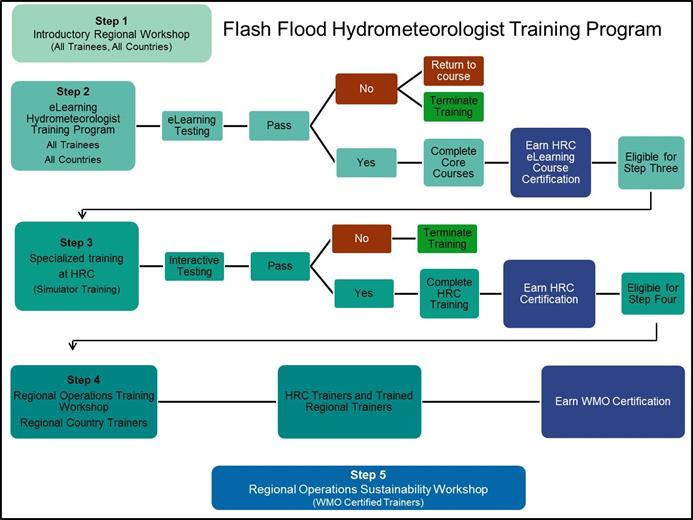
13 the FFGS products. He explained that firstly, weather analysis and forecasting tools and models such as surface charts, 850 HPa and 500 HPa charts, and NWP QPF products should be analyzed to see the current weather outlook and weather conditions are favorable for the occurrences of flash floods; secondly, mesoscale and nowcasting analysis including RADAR and weather satellite images, if available, should follow to make smaller scale analysis such as instability and development of convective clouds; thirdly, FFGS products should be interpreted starting from diagnostic products and ending with prognostic products; and finally, the preparation of flash flood bulletins and warnings should be made provided conditions for the flash flood occurrences are suitable. In Mr. Sayin s first presentation, he presented a flash flood event that occurred in South East Europe on 6-8 March 2016 causing loss of lives and extensive economical losses in Montenegro and Serbia. He articulate that flash floods and floods that were induced by the central Mediterranean depression associated with frontal system and coupled with the orographic lifting are very common phenomenon in the region. In his second presentation, he presented a case study on a flash flood event that took place in Georgia on June 2015 in which more than forty people were killed and millions of dollars economical damage were inflicted according to the UNDP report. He stated that the flash flood was caused by the occurrence of severe convective storms during the night. He said that there were two important lessons learned from this case study: firstly, convective rainfall may not be detected neither by FFG system nor NWP models. If this is the case, weather satellite and/or weather RADAR nowcasting products, depending on the availability of them, are very useful tools to be used in flash flood forecasting. Secondly, 24/7 working hours are extremely important because flash flood may happen at any time, which was the case in this event BSMEFFGS Verification Results Mr Ayhan Sayin s presentation built upon that of Mr Eylon Shamir s presentation where he demonstrated the operational capabilities of the Black Sea and Middle East Flash Flood Guidance (BSMEFFG) system and illustrated the use of its derived products. He also provided an overview of verification results for the BSMEFFG system for the years of 2013 and He stated that Probability of Detection (PoD) was 70% in 2013, while it was 55% in He concluded his presentation explaining that PoD was lower in 2014 because of the fact that frequency of the convective storms were higher and that satellite estimation and numerical weather forecasts of precipitations intensity and amount are relatively poor in comparison with synoptic and mesoscale systems. 4.6 MRCFFGS Hydrometeorological Training Mr Eylon Shamir stated that training was an integral part of the project, and extensive training would be provided to the participant countries forecasters. He showed the schematic diagram outlining the FFGS hydrometeorological training programme, which is contained in ANNEX III of this report. He explained that it consisted of five steps: Step 1 introductory regional workshop; Step 2 elearning hydrometeorological training; Step 3 specialized training at HRC; Step 4 regional operations training workshop; and Step 5 regional operational sustainability workshops. He stated that when the training was completed, forecasters should be confident and competent to use FFGS products for flash flood forecasting and the provision of early warnings. He emphasized the differences between previous training activities and new ones that Step-2 on-line training has been developed. He stated that it consists of five major modules: elements of meteorology, elements of hydrology, Flash Flood Guidance products, GIS, and remote sensing. He stressed that on-line training 11
14 is a prerequisite to be eligible to attend the Step-3 operational training at HRC. He further stated that those forecasters who successfully completed Step-3 and 4 training may receive WMO flash flood trainer certificate and involve in Step-5 sustainability training. During the facilitated discussions, participants stated that four MRC staff and one forecaster from each NMHS have attended two operational training at HRC in two different occasions. They suggested that within the scope of the new flash flood hydrometeorlogical training programme, more forecasters from the participating NMHSs should be involved in training because those MRC staff that had participated in the operational training are no longer working at MRC. It was also stated that employment duration of the MRC staff, who are recruited from the member countries, are limited to a maximum of six years. This could be a hurdle for the sustainability of provision of training activities by the MRC. 4.8 Project Implementation Plan Mr Ayhan Sayin described the revised project implementation plan, showing its major tasks, milestones, and timeline. The following activities were mentioned and had focused discussions on how the process may move forward: 1) joint Mekong River (MR) Committee meeting will decide on the submission of the letters of Agreement (LoC) to WMO and conclusion of a cooperation agreement with WMO; 2) provision of newly available historical hydrometeorological and in-situ data to HRC through the RC; 3) on-site installation of the upgraded system at the Regional Center; 4) completion of on-line training courses (Step 2); 5) operational training at HRC (Step 3); 6) other training activities (Step 4 and 5). Participants unanimously agreed on the implementation of the revised implementation plan saying that they would do their utmost to comply with the plan. Revised MRCFFGS implementation plan is provided in ANNEX VI of this document. 4.9 Management Aspects According to the typical implementation requirements document, a Project Steering Committee (PSC) is established to provide overall governance of the project and its related activities throughout the duration of the project. Its membership and the terms of reference are confirmed and amended as deemed necessary during the first constituting session of the PSC. The PSC consists of focal points or their alternates from each of the participating NMHSs as nominated by the Member s Permanent Representatives and representatives of the project partners, while additional experts/representatives are to be invited by the PSC as needed on an ad-hoc basis, and observers may also be invited by the PSC to participate in meetings. On the other hand, the project governance model for the current MRCFFG project is different than described above as it was implemented through MRC rather than through NMHSs, as it predated the WMO-NOAA NWS-HRC-USAID partnership. All decisions regarding the implementation of this project have been taken by the joint MR committee that consists of representatives of the national MR committees. As presented and discussed at the meeting, the existing governance structure of the MRCFFG system could be aligned with that of other regional FFG projects. 5. Conclusions of the Steering Committee Meeting 1 During the first Steering Committee Meeting of the MRCFFGS that consisted of representatives of MRC, Cambodia, Lao PDR, Thailand, Viet Nam, WMO, and HRC; participants discussed a variety issues in accordance with the meeting agenda and reached the following conclusions: 1. There was an agreement among the participants that an upgraded MRCFFG system would significantly improve the capabilities of NMHSs in Southeast Asia to produce timely and 12
15 accurate flash flood warnings induced by heavy rainfall, thereby contributing to disaster risk reduction by saving lives and reducing property damages. 2. Participants understood the roles and responsibilities of the Regional Centre and NHMSs, noting that cooperation and collaboration amongst the project partners is the key to success for the project. 3. Participants noted and expressed their appreciations on the upgraded MRCFFG system in which a number of new features have been included such as WRF mesoscale NWP model and its associated QPF, microwave adjusted GHE, snow products, and the dashboard. They agreed that the upgraded system would enhance capacities of the participating NMHSs to issue flash flood warnings. 4. Participants became familiar with the updated MRCFFGS forecaster interface and its products: Global Hydro Estimator (GHE), Microwave adjusted GHE (MWGHE), gauge Mean Areal Precipitation (MAP), merged MAP, Average Soil Moisture, Flash Flood Guidance (FFG), Flash Flood Threats (FFTs), Forecast Mean Areal Precipitation (FMAP), Mean Areal Temperature (MAT), and satellite snow coverage as well as dashboard. Participants agreed that these were complementary with each other and provided a good oversight of what conditions existed and what might happen over the forecast horizon. 5. Participants noted that the MRCFFG system became operational in 2009 and agreed on the provision of new historical hydrometeorological and geophysical spatial data, if such data exist, to the Hydrologic Research Center (HRC) through the RC to update model parameters and update the bias corrections. 6. Participants further noted the necessity of sharing real-time data through the GTS to allow realtime bias precipitation adjustment and use of other surface data in model calculations. They agreed to provide their updated lists of SYNOP stations reporting to GTS and their metadata to HRC. They further noted that inclusion of more in-situ observations into MRCFFG system that are not reporting to the GTS may improve the quality of its products. 7. Participants agreed that inclusion of available weather RADAR precipitation data may improve the accuracy of the MRCFFG products and affirmed that urban flash flooding is very important problem in the region during the wet season. 8. Participants urged linkages the between Severe Weather Forecasting Demonstration Project Southeast Asia (SWFDP-SA) and MRCFFG system and agreed that use of its products such as high resolution NWP QPF, if available, may improve the accuracy of assessing the flash flood threats to provide better flash flood warnings, particularly in the mountainous regions. They recommended that satellite nowcasting products retrieved from HIMAWARI satellite data of Japan Meteorological Agency, currently being the most advanced meteorological satellite, may also significantly contribute to the improvement of accuracy of flash flood warnings. 9. Participants agreed on the revised implementation plan and noted the milestones such as convening of the Joint MR Committee meeting to discuss submission of LoC from the participating countries to WMO and concluding a cooperation agreement between MRC and WMO; provision of hydrometeorlogical and in-situ data; on-site system installation; and flash flood hydrometeorlogist training programme. 10. Participants agreed on the implementation of the flash flood hydrometeorlogical training programme (step 1-5) and that efforts should focus on training forecasters from the participating NMHSs, stressing that the majority of the previous trainees who attended the 13
16 operational training at HRC were from MRC staff - four trainees from MRC and one trainee from each NMHS. 11. All aspects pertaining to the management of the MRCFFG system such as installation of the upgraded MRCFFG system at the MRC and conclusion of a cooperation agreement between the MRC and WMO, will be considered at the earliest possible joint MR committee as this is the current governing body of this regional project. 12. Noting that the MRCFFG products for areas of Thailand, that are outside the Mekong River Watershed, are currently masked on the MRCFFG forecaster console and MRC web portal, participants agreed that MRC and member states will work together to define a new format of the MRCFFG products that will be put on the MRC public web portal as requested by the representatives of Thailand who indicated that the mask could be removed after a satisfactory format would be agreed upon. 13. Participants appreciated that efforts are being made to develop the Flash Flood Guidance products for Myanmar and noted that decision on the inclusion of Myanmar in the MRCFFG System will only be made by the joint Mekong River Committee. 6. Closing of the Steering Committee Meeting 1 Closing remarks were made by WMO, HRC, MRC, and participants. Thanks were also extended to all attendees for their active participation in the workshop and spirited involvement in the discussions, which contributed to the successful conclusion of the workshop. 14
17 ANNEX I FIRST STEERING COMMITTEE MEETING (SCM 1) MEKONG RIVER COMMISSION FLASH FLOOD GUIDANCE (MRCFFG) SYSTEM Phnom Penh, Cambodia 29 November 1 October 2016 List of Participants MRC Mr Oudomsack Philavong Team Leader Flood Forecasting Team, Technical Support Division, Office of the MRC Secretariat in Phnom Penh (OSP), # 576 National Road No. 2, Chak Angre Krom, Meanchey, P.O. Box 623, Phnom Penh, Cambodia Dr Paradis Someth Water & Climate Change Monitoring Specialist Tech nical Support Division, Office of the MRC Secretariat in Phnom Penh (OSP), # 576 National Road No. 2, Chak Angre Krom, Meanchey, P.O. Box 623, Phnom Penh, Cambodia Mr Nguyen Quoc Anh Operational Hydro-Meteorologist/Forecaster Flood Forecasting Team, Technical Support Division, Office of the MRC Secretariat in Phnom Penh (OSP), # 576 National Road No. 2, Chak Angre Krom, Meanchey, P.O. Box 623, Phnom Penh, Cambodia Mr Yos Saravy System and IT Assistant Flood Forecasting Team, Technical Support Division, Office of the MRC Secretariat in Phnom Penh (OSP), # 576 National Road No. 2, Chak Angre Krom, Meanchey, P.O. Box 623, Phnom Penh, Cambodia Mr Nuon Kunthea Mapping and GIS Assistant Flood Forecasting Team, Technical Support Division, Office of the MRC Secretariat in Phnom Penh (OSP), # 576 National Road No. 2, Chak Angre Krom, Meanchey, P.O. Box 623, Phnom Penh, Cambodia Dr Phung Katry Hydrologist Tel: , Ext HP: Fax: oudomsack@mrcmekong.org Tel: , Ext HP: Fax: someth@mrcmekong.org Tel: , Ext HP: Fax: anh@mrcmekong.org Tel: , Ext HP: Fax: saravy@mrcmekong.org Tel: , Ext HP: Fax: kunthea@mrcmekong.org Tel: , Ext HP:
18 Flood Forecasting Team, Technical Support Division, Office of the MRC Secretariat in Phnom Penh (OSP), # 576 National Road No. 2, Chak Angre Krom, Meanchey, P.O. Box 623, Phnom Penh, Cambodia Ms Sotheavy Cheap Secretary Flood Forecasting Team, Technical Support Division, Office of the MRC Secretariat in Phnom Penh (OSP), # 576 National Road No. 2, Chak Angre Krom, Meanchey, P.O. Box 623, Phnom Penh, Cambodia Fax: Phungkatry11@gmail.com Tel: , Ext HP: or Fax: sotheavy@mrcmekong.org Mr Oum Ryna Director Department of Meteorology, Ministry of Water Resources and Meteorology (MOWRAM) # 364 Monivong Blvd, Sangkat Phsar Doerm Thkouv, Khan Chamkar Mon, Phnom Penh, Cambodia Cambodia Tel: HP: Fax: rynaoum@yahoo.com Mr So Im Monichoth Deputy Director Department of Meteorology, Ministry of Water Resources and Meteorology (MOWRAM) # 364 Monivong Blvd, Sangkat Phsar Doerm Thkouv, Khan Chamkar Mon, Phnom Penh, Cambodia Ms Pot Peou Vice Chief of Research and Flood Forecasting Office Department of Hydrology and River Works, Ministry of Water Resources and Meteorology # 364 Monivong Blvd, Sangkat Phsar Doerm Thkouv, Khan Chamkar Mon, Phnom Penh, Cambodia Mr Pheng Seng Meng Technical Officer Department of Hydrology and River Works, Ministry of Water Resources and Meteorology (MOWRAM) #364 Preah Monivong Blvd., Phnom Penh, Cambodia Mr Thoun Sokchea Deputy Director IKM Department, Cambodia National Mekong Committee # 364 Monivong Blvd, Sangkat Phsar Doerm Thkouv, Khan Chamkar Mon, Phnom Penh, Cambodia Mr Chhun Dara Technical Staff IKM Department, Cambodia National Mekong Committee # 364 Monivong Blvd, Sangkat Phsar Doerm Thkouv, Khan Chamkar Mon, Phnom Penh, Cambodia Tel: HP: Fax: Tel: Fax: Tel: Fax: Tel: Fax: Tel: Fax: Mr Khanmany Khounphonh Director General Lao PDR Tel: HP:
19 Hydrological Division, Department of Meteorology and Hydrology, Ban Akard, Souphanouvong Avenue, Sikhottabong District, Vientiane, Lao PDR Mr Prasith Deemaneevong Deputy Head Hydrological Division, Department of Meteorology and Hydrology, Ban Akard, Souphanouvong Avenue, Sikhottabong District, Vientiane, Lao PDR Tel: HP: Fax: Dr Tin Mar Htay Technical Officer Office No. 5, Department of Meteorology and Hydrology, (DMH), Ministry of Transport and Communication, Nay Pi Taw, Myanmar Myanmar Tel: HP: Fax: Mr Win Maw Assistant Director Hydrological Division, Department of Meteorology and Hydrology, (DMH), Ministry of Transport and Communication, Nay Pi Taw, Myanmar Assoc. Prof. Chaiyuth Sukhsri Technical Advisor/Member of TNMC Secretariat TNMS, Mekong Management Bureau, Department of Water Resources, Ministry of Natural Resources and Environment, 180/3 Rama 6 Road, Soi Phibul Watana Building,, Phayathai, Bangkok 10400, Thailand Thailand Tel: HP: Fax: HP: , or winmaw.kk@gmail.com dg.dmh1@gmail.com Tel: HP: Fax: csschaiyuth@yahoo.com Mr Surapong Sarapa Director Central Weather Forecast Division, weather Forecast Bureau, Thai Meteorological Department, # 4353, Sukumvit Road, Bang-na, Bangkok 10260, Thailand Tel: HP: Fax: kopaball@hotmail.com Mr Phung Tien Dung Deputy Chief Hydrology Forecasting Division (Central, Highland Southern Regional), National Center Hydro- Meteorological Forecasting (NCHMF), # 4 Dang Thai Than Street, Hoan Kiem, Ha Noi, Viet Nam Mr Ayhan Sayin Scientific officer World Meteorological Organization Hydrological Forecasting & Water Resources Division 7bis, avenue de Paix, Case Postale No. 2300, 1211 GENEVA 2 Switzerland Viet Nam WMO Tel: HP: Fax: ptdung77@gmail.com Phone: + 41 (0) Fax: +41 (0) asayin@wmo.int Dr Eylon Shamir Ph.D. HRC Phone:
20 Hydrologic Research Center West Bernardo Court, Suite 375 San Diego, CA

21 ANNEX II FIRST STEERING COMMITTEE MEETING (SCM 1) MEKONG RIVER COMMISSION FLASH FLOOD GUIDANCE (MRCFFG) SYSTEM Phnom Penh, Cambodia 29 November 1 October 2016 Final Agenda Day I 08:30-09:00 Registration 09:00-09:30 Opening Ceremony Welcome speeches by the representatives of MRC, WMO, and HRC 09:30 10:00 Photo session 10:00 10:30 Coffee Break 10:30 10:45 Selection of the session chair and review of the agenda and Participants selfintroductions (All) 10:45 11:15 Objectives of the meeting and overview of the global FFG System and (WMO) 11:15-11:30 MRCFFG Project implementation status (HRC) 11:30 12:30 Overviews of existing flash flood forecasting and warning infrastructures of the participating countries (Country presentations) Local capacity for the provision of flash flood early warnings Local capacity for weather forecasting and nowcasting (Global and limited Area Models, meteorological data processing and visualization software) Current hydrometeorological networks (number and types of meteorological and hydrological stations, data dissemination methods, GTS reporting, radiosonde stations, databases) Organizational structure and human resources (7/24 working, number of trained forecasters, forecasting department 19
22 Collaborations with emergency management agencies other governmental and non-governmental (private sector, TV, Radio etc.) organizations o Overview of products and services provided 12:30 14:00 Lunch Break 14:00 14:30 Roles and Responsibilities of the Regional Centre and participating NMHSs (WMO) 14:30-15:00 Current operational status of MRCFFG System and availability of MRCFFG services and producs to the participating countries for issuance of flash flood warnings (MRC) 15:00 15:30 Operational Aspect of BSMEFFG System (WMO) 15:30 16:00 Coffee Break 16:00-16:30 Organizational and Management Aspect and Project Cycle (WMO) 16:30 17:00 SWFDP-Southeast Asia (WMO) 19:00 Welcome dinner DAY II 09:00 09:15 Overview of day I presentations/discussions (All) 09:15 10:30 MRCFFG system development and review of theoretical background (HRC) Design Philosophy and Introduction to Modelling Components Data Used for Development Satellite Precipitation Estimation and bias adjustments Soil Moisture Model and Parameterization 10:30 11:00 Coffee Break 11:00-11:30 MRCFFG system development and review of theoretical background (HRC) (Cont.) Runoff Estimation Flash Flood Guidance Flash Flood Threat 11:30-12:00 Overview of the Mekong River Commission Flash Flood Guidance products (HRC) Diagnostic precipitation products (GHE, MWGHE, Merged MAP) Prognostic precipitation products (WRF, FMAP) Soil Moisture (ASM) Flash Flood Guidance (FFGS) 20
23 Threats (IFFT, PFFT, FFFT) 12:00 12:30 Demonstration of an Operational FFG System: Black Sea and Middle East Flash Flood Guidance (BSMEFFG) System (WMO) 12:30 14:00 Lunch Break 14:00 14:30 How to prepare flash flood warnings: Methodology (WMO) Weather analysis and forecasting Mesoscale and Nowcasting Analysis Weather RADAR and Satellite images Interpretation of FFG Products 14:30 15:00 A flash flood case study (WMO) 15:00 15:30 A flash flood case study (HRC) 15:30 16:00 Coffee Break 16:00 16:30 Preparation of Flash Flood Bulletins and their verification (WMO) 16: 30 17:00 Concept of Operation (WMO) Day III 09:00 09:15 Overview of previous day presentations/discussions (All) 09:15 10:30 Hands-on Exercise for Past Events in the region (Guided by HRC, All) (example daily operations ) Daily Weather Briefing Hydrologic Output FFG Product Analysis Flash Flood Threats Discussion 10:30 11:00 Coffee Break 11:00 11:30 Advances in FFG System (HRC) Multi-Model QPF Ingestion in FFGS Landslides Urban flooding early warning system Riverine Routing 11:30 12:00 Flash Flood Hydrometeorlogist Training Programme: Step 1-5 (HRC) 12:00 12:30 Cooperation Agreement between WMO and the Regional Centre (WMO) 12:30 14:00 Lunch Break 14:00 14:30 Review of Work Plan Adjustments and next steps 21
24 14:30 15:30 Final Discussions, conclusion and recommendation for further development (All) 15:30-16:00 Closing statements & closure of the meeting - End of Workshop 22
25 ANNEX III Flash Flood Hydrometeorological Training Programme During the course of the MRCFFG System implementation for a region, training will be provided to forecasters on the scientific basis and operations of the system. The training programme is a five step blended learning model - known as the Flash Flood Hydrometeorologist Training (FFHT) Programme. The five step programme includes: 1. Introductory in-country workshops and meetings; 2. elearning programme to support system operations, product interpretation, system validation, including the use, management, and interpretation of output from the system, and the development of protocols to alert response agencies and the public of an impending or existing threat. For each completed course learners earn an HRC Course Certification, once they have completed the core curriculum they are eligible for Step Three; 3. Advanced Operations and Interactive Simulator Training at the Hydrologic Research Centre to assist with reviewing and assessing the operating versions of the system. Included is the Interactive Simulator training to provide the user with the skill to interpret and validate skill using real flash flood events. Upon successful completion of the Advanced Operations Training each learner earns an HRC Advanced Training Operations Certification; once they have completed this step they are eligible for Step Four; 4. Regional Operations Training Workshop where HRC trainers in combination with Trained Regional Trainers provide in-country workshop. Upon successful completion of this stage of training Regional Trainers earn a WMO Certification as hydrometeorologists; and 5. Regional Operation Sustainability Workshop led by WMO certified trainers acts as refresher training in operations, overview of data requirements, system verification and user validation
26 - 24 -
27 ANNEX IV Data Requirements For the development and operation of Flash Flood Guidance System, local historical and/or climatological hydrometeorological and geomorphologic, and real-time data are required. They are used for, among others, model parameterizations, calibrations, bias adjustments. Use of the higher resolution spatial and temporal local data in the FFG models is critical for the system performances. At the absence of local data, they will be obtained from international organizations like soil data from FAO (Food and Agricultural Organization). Therefore, participant countries are advised to collect, arrange and provide the following data types in required formats, depending on the availability of them. A. NMHS Capacity Information Institutional capacities, responsibilities: Hydrometeorological observation network, data processing and visualization tools; River and flash flood forecasting and early warning tools; Nowcasting tools; QPE/QPF tools and models; IT capabilities; and Organization structure (forecasting department, regional offices etc.,). B. Spatial GIS Data, Maps Digital terrain elevation data (quality controlled); Stream network; Lakes/reservoirs/wetlands; Soil type, texture and depth; Vegetation cover, and land usage; and Monthly climatological maps of precipitation, temperature and potential evapotranspiration. C. Spatial GIS Data, Maps Channel cross-sectional Information for natural channels with drainage areas less than 2,000 km 2. The following hydrometeorological data, 5-20 years in record length, preferable in digital format: Precipitation (hourly, daily, monthly), covering at least past 5 years as much as available; Surface air temperature (hourly, daily, monthly); Top soil moisture (daily, weekly, monthly); Streamflow discharge for local streams with drainage areas less than 2000 km 2 (hourly, daily, monthly);if streamflow discharge data are unavailable, stream stage data (hourly, daily, monthly) and associated stage-discharge curves (rating curves), also for local streams;
28 Snow depth, snow water equivalent (SWE) and snow coverage (hourly, daily monthly); Flood frequency analysis (regional and local); Flash flood occurrences (regional and local); Stream geometry studies for small streams; Climatological precipitation and flood studies; and Karst flow measurement studies. If above data are unavailable, such hydro-meteorological and climatological data as monthly precipitation; surface air temperature; pan-evaporation/evapotranspiration; soil moisture; stream flow; radiation; wind and humidity; snow depth and coverage and SWE should be provided. D. Real-Time Data Requirements FFG system uses real-time meteorological observations in WMO synop format that are disseminated through WMO GTS, including the following parameters, among others: Precipitation; Surface temperature, humidity, wind speed/direction, pressure, solar radiation; Snow depth and SWE; and Soil moisture. Besides the synoptic reports, if additional hydrometeorological observations are available, that would be transferred to the regional centre through ftp services, may improve the system performances. NMHS Observation Network Metadata Requirements The following metadata for the rain gauges, weather stations, and stream gauges are to be provided: Geographical locations (latitude and longitude in decimal degrees); Elevation in meters; Type of stations and WMO station numbers(synoptic, climate); Current operational status (Automatic, Manuel); Observation interval (hourly, 3-hourly, 6-hourly etc); Available sensors (Precipitation, Temperature, Humidity, Soil Moisture, Dew Point, Snow, SWE etc.); Total number of stations and number of synoptic stations that reports to GTS; Data transmission type (HF/VHF radio, wide area network, GPRS, satellite etc.); Data quality control applied (y or n); and Existing database (Oracle, Informix etc.)
29 Data Priorities for the CARFFG System ANNEX V REAL-TIME DATA Real-time data is considered the highest priority for the operational FFG System. Priority Data Type Time Resolution 1 Meta data for all gauges + 1 Precipitation * Hourly or 6-hourly preferred -OR- 3-hourly or daily 1 Surface temperature * Hourly or 6-hourly preferred 2 Snow depth / snow water equivalent 6-hourly or daily 3 Stream flow 6-hourly or daily 4 Soil moisture measurements 6-hourly or daily 5 Humidity, wind, solar radiation 6-hourly or daily + Meta data includes station name &/or identifier, coordinates in LAT/LON, and elevation * Precipitation, temperature, and snow observations may be used directly by system. Soil moisture, stream flow and other meteorological observations (frequent less available) are provided as information through system interface and may be used by forecaster to evaluate certain system output products. HISTORICAL DATA Historical data is necessary for model development and evaluation of FFG System components. The items listed below in Section 1 are higher priority, and considered equal level of priority as the corresponding priority levels of real-time data. Additional information requested in Section 2 and 3 may be during development as such data is available. The priority assignments are grouped together for Sections 2 and 3, and follow the priority level of Section 1. (1) FOR ANALYSIS PERIOD OVERLAPPING SATELLITE ESTIMATES: 1.a) PRECIPITATION BIAS ANALYSIS Priority Data Type Time Resolution Period of Record 1 Gauge Precipitation* Hourly preferred current -OR- 3- or 6- hourly -OR- Daily 1 Meta data for all gauges + * Gauges with good spatial coverage and relatively uniform density across country. Quality controlled data is required. Typically, most information is available from daily reporting stations. + Meta data includes station name &/or identifier, coordinates in LAT/LON, and elevation
30 1.b) Hydrologic Model Calibration Priority Data Type Time Resolution Period of Record 1 Meta data for all gauges 2 Surface air temperature Hourly or Daily current preferred -OR- 3- or 6- hourly 3 Stream flow data ++ Hourly or Daily current 4 Pan evaporation / Daily preferred current evapotranspiration -OR- weekly or monthly 4 Snow depth, snow water Daily preferred current equivalent (SWE) -OR- weekly or monthly 4 Measured soil moisture Daily preferred current -OR- weekly or monthly 5 Radiation, wind & humidity Hourly or Daily current ++ if stream flow data is unavailable, stream stage (height) data plus rating curve may be used. 1.c) Hydrologic Model Calibration Spatial Data Priority Data Type Resolution Period of Record 1 Soil type, soil texture, soil depth 1 Land cover/vegetation cover/ Land use 2 Stream survey reports / channel geometry information Surveys within For small streams, draining < 2000km 2 recent years 3 Return period flow estimates & For small streams, draining < 2000km 2 4 Spatial coverage of karst regions & if return period flows are unavailable, stream flow data for years may be used to derive these estimates. (2) ADDITIONAL HISTORICAL DATA (NOT OVERLAPPING SATELLITE ESTIMATES, BUT RECENT TIME PERIOD PREFERRED* Priority Data Type Time Resolution Period of Record 1 Precipitation Hourly or Daily 5-20 years 1 Surface air temperature Hourly or Daily 5-20 years 1 Stream flow data ++ Hourly or Daily 5-20 years 2 Pan evaporation / Hourly or Daily 5-20 years evapotranspiration preferred -OR- weekly or monthly
31 3 Snow depth, snow water Daily preferred 5-20 years equivalent (SWE) -OR- weekly or monthly 3 Measured soil moisture Daily preferred 5-20 years -OR- weekly or monthly 5 Radiation, wind & humidity Hourly or Daily 5-20 years preferred -OR- weekly or monthly * spatial and period of record correspondence between meteorological (P,T,Evap,SWE) and hydrological (Q, soil moisture) observations is desired for hydrologic model calibration. If corresponding time series are unavailable, data is used to evaluate climatological response. ++ if stream flow data is unavailable, stream stage (height) data plus rating curve may be used. & if return period flows are unavailable, streamflow data for years may be used to derive these estimates. (3) ADDITIONAL HISTORICAL STUDIES Priority Data Type Resolution Period of Record 4 Location of reservoirs 4 GIS layers of watershed boundaries or stream network % 5 Historical flash flood occurrences or reports 6 Flood frequency studies 6 Karst flow measurements or studies % digital GIS layers based on digitization of topographic map preferred and used to evaluate automated watershed delineation results
32 ANNEX VI Revised MRCFFGS Implementation Plan TASK NAME Steering Committee Meeting 1 Joint MR Committee meeting to discuss submission of LoC and Cooperation agreement with WMO Letters of commitment (LoC) and points of contact provided to WMO Server Purchase by HRC Months 2018 Months Provision of newly available historical hydromet data to HRC through the RC Complete updated version of the system On-site system installation at the Regional Center Complete on-line courses - Step 2 training. Provision of real-time data to HRC by the Regional Center and participating countries Operational training at HRC - Step 3 training Steering Committee Meeting #2 Follow-up operational workshop (step 4) Sustainability training (Step 5)

33 Current MRCFFGS Forecaster Console ANNEX VII

34 Updated MRCFFGS Forecaster Console ANNEX VIII

35 New MRCFFGS Dashboard ANNEX IX


36 MRCFFGS Product Coverages ANNEX X


37 ANNEX XI Flash Flood Advisory issued by the Tai Meteorological Department. Flash Flood Warning issued by the National Disaster Warning Center of Thailand
Regional Flash Flood Guidance and Early Warning System
 WMO Training for Trainers Workshop on Integrated approach to flash flood and flood risk management 24-28 October 2010 Kathmandu, Nepal Regional Flash Flood Guidance and Early Warning System Dr. W. E. Grabs
Overview and purposes of the meeting
 Overview and purposes of the meeting 1 Flash Floods vs. River Floods Riverine Flooding: is caused by heavy rainfall (and/or snow melt) over long periods e.g., days, leading to rising water levels and flooding
Overview of the global FFGS
 Overview of the global FFGS 1 Definition of the Problem While there are several types of floods, flash floods are the most dangerous. Flash Flood is: a flood of short duration with a relatively high peak
Global Flash Flood Guidance System Status and Outlook
 Global Flash Flood Guidance System Status and Outlook HYDROLOGIC RESEARCH CENTER San Diego, CA 92130 http://www.hrcwater.org Initial Planning Meeting on the WMO HydroSOS, Entebbe, Uganda 26-28 September
An Example of FFGS Implementation: Black Sea and Middle East FFG System. WMO; Name of Department (ND)
") An Example of FFGS Implementation: Black Sea and Middle East FFG System WMO; Name of Department (ND) Black Sea and Middle East FFGS 1 Flash Floods in Turkey Flood Frequencies: 80 60 40 20 0 Human and Economic
An Example of FFGS Implementation: Black Sea and Middle East FFG System WMO; Name of Department (ND) Black Sea and Middle East FFGS 1 Flash Floods in Turkey Flood Frequencies: 80 60 40 20 0 Human and Economic
Second Steering Committee Meeting of the Central Asia Region Flash Flood Guidance (CARFFG) System. Overview of the Global FFG System
 System. Overview of the Global FFG System") Second Steering Committee Meeting of the Central Asia Region Flash Flood Guidance (CARFFG) System Overview of the Global FFG System 1 Impacts of Hydro-meteorological Hazards Total number of reported hydro-meteorological
Second Steering Committee Meeting of the Central Asia Region Flash Flood Guidance (CARFFG) System Overview of the Global FFG System 1 Impacts of Hydro-meteorological Hazards Total number of reported hydro-meteorological
Flash flood forecasting and warning infrastructures of National Meteorology and Hydrological Services of Cambodia
 Development and Implementation of the South East Asia Flash Flood Guidance System (SEAFFGS) Ha Noi, Viet Nam, 20-23 November 2017 Flash flood forecasting and warning infrastructures of National Meteorology
Haiti and Dominican Republic Flash Flood Initial Planning Meeting
 Dr Rochelle Graham Climate Scientist Haiti and Dominican Republic Flash Flood Initial Planning Meeting September 7 th to 9 th, 2016 Hydrologic Research Center http://www.hrcwater.org Haiti and Dominican
Development and Implementation of the Haiti and Dominican Republic Flash Flood Guidance (HDRFFG) System. Introduction to the Global FFG System
 System. Introduction to the Global FFG System") Development and Implementation of the Haiti and Dominican Republic Flash Flood Guidance (HDRFFG) System Introduction to the Global FFG System 1 Definition of the Problem Flash Flood is: a flood of short
Development and Implementation of the Haiti and Dominican Republic Flash Flood Guidance (HDRFFG) System Introduction to the Global FFG System 1 Definition of the Problem Flash Flood is: a flood of short
Flash Flood Guidance Gazette
 Volume 1, Issue 4 December 2012 Flash Flood Guidance Gazette Flash Flood Guidance (FFG) Gazette, a bi-annual newsletter bringing users of FFG products all the latest news operational information, technical
Flash Flood Guidance System On-going Enhancements
 Flash Flood Guidance System On-going Enhancements Hydrologic Research Center, USA Technical Developer SAOFFG Steering Committee Meeting 1 10-12 July 2017 Jakarta, INDONESIA Theresa M. Modrick Hansen, PhD
Demonstration of an Operational FFG System: Black Sea and Middle East FFG System. WMO; Name of Department (ND)
") Demonstration of an Operational FFG System: Black Sea and Middle East FFG System WMO; Name of Department (ND) Black Sea and Middle East FFGS 1 Black Sea and Middle East FFGS Black Sea and Middle East Flash
Demonstration of an Operational FFG System: Black Sea and Middle East FFG System WMO; Name of Department (ND) Black Sea and Middle East FFGS 1 Black Sea and Middle East FFGS Black Sea and Middle East Flash
ME KONG RIVER COMMISSION FLASH FLOOD GUIDANCE SYSTEM (MRCFFGS)
") NATIONAL HYDRO-METEOROLOGICAL SERVICE IN VIETNAM NATIONAL CENTER FOR HYDRO-METEOROLOGICAL FORECASTING ME KONG RIVER COMMISSION FLASH FLOOD GUIDANCE SYSTEM (MRCFFGS) http://www.nchmf.gov.vn 29 Nov 1 Dec
NATIONAL HYDRO-METEOROLOGICAL SERVICE IN VIETNAM NATIONAL CENTER FOR HYDRO-METEOROLOGICAL FORECASTING ME KONG RIVER COMMISSION FLASH FLOOD GUIDANCE SYSTEM (MRCFFGS) http://www.nchmf.gov.vn 29 Nov 1 Dec
FFGS Advances. Initial planning meeting, Nay Pyi Taw, Myanmar February, Eylon Shamir, Ph.D,
 FFGS Advances Initial planning meeting, Nay Pyi Taw, Myanmar 26-28 February, 2018 Eylon Shamir, Ph.D, EShamir@hrcwater.org Hydrologic Research Center San Diego, California FFG System Enhancements The following
CARFFG System Development and Theoretical Background
 CARFFG Steering Committee Meeting 15 SEPTEMBER 2015 Astana, KAZAKHSTAN CARFFG System Development and Theoretical Background Theresa M. Modrick, PhD Hydrologic Research Center Key Technical Components -
BLACK SEA AND MIDDLE EAST FLASH FLOOD GUIDANCE SYSTEM
 Republic of Turkey Ministry of Forestry and Water Works General Directorate of Turkish Meteorological Service BLACK SEA AND MIDDLE EAST FLASH FLOOD GUIDANCE SYSTEM Needs Floods occur mostly as flash floods
Haiti-Dominican Republic Flash Flood Guidance (HDRFFG) System: Development of System Products
 System: Development of System Products") Haiti-Dominican Republic Flash Flood Guidance (HDRFFG) System: Development of System Products Theresa M. Modrick, PhD Hydrologic Research Center HDRFFG Initial Planning Meeting 07-09 Sep 2015 Santo Domingo,
Haiti-Dominican Republic Flash Flood Guidance (HDRFFG) System: Development of System Products Theresa M. Modrick, PhD Hydrologic Research Center HDRFFG Initial Planning Meeting 07-09 Sep 2015 Santo Domingo,
National Hydro-Meteorological Service
 National Hydro-Meteorological Service IMPROVING INSTITUTIONAL NAL CAPACITY (IN CASE OF VIETNAM) Country Report for the first meeting of the RA-II (Asia) Working Group on Hydrological Forecasts and Assessments
Flash Flood Guidance: SARFFG modeling system
 Flash Flood Guidance: SARFFG modeling system Eugene Poolman Chief Forecasting: Disaster Risk Reduction RSMC Pretoria FCAST-PRES-20141021-001.1 Flash Floods vs. River Floods River floods are caused by heavy
The MRC Mekong Flood Forecasting and MRC Flash Flood Guidance Systems
 MEKONG RIVER COMMISSION The MRC Mekong Flood Forecasting and MRC Flash Flood Guidance Systems NGUYEN TIEN KIEN Regional Flood Management and Mitigation Centre Phnom Penh, Cambodia Outline 1. Operational
FFGS Additional Functionalities and Products. Konstantine P. Georgakakos, Sc.D. HYDROLOGIC RESEARCH CENTER 23 May 2018
 FFGS Additional Functionalities and Products Konstantine P. Georgakakos, Sc.D. HYDROLOGIC RESEARCH CENTER 23 May 2018 Advanced Functionalities 0. Multi-Model QPF A. Urban Flash Flood Warning B. Riverine
Application of Satellite Data for Flood Forecasting and Early Warning in the Mekong River Basin in South-east Asia
 MEKONG RIVER COMMISSION Vientiane, Lao PDR Application of Satellite Data for Flood Forecasting and Early Warning in the Mekong River Basin in South-east Asia 4 th World Water Forum March 2006 Mexico City,
World Meteorological Organization Working together in weather, climate and water
 WMO World Meteorological Organization Working together in weather, climate and water Strengthening Regional Cooperation to Support Forecasting with Multi-Hazard Approach in RA IV SWFDP concepts and lessons
FFGS Concept HYDROLOGIC RESEARCH CENTER. 2 May 2017
 FFGS Concept HYDROLOGIC RESEARCH CENTER 2 May 2017 Research and Development History 1970-1988: US NWS Produces FFG statistically for each River Forecast Center. Also, research in adaptive site specific
Recent development of the National Hydro-Meteorological Service (NHMS) of Viet Nam for disaster risk reduction
 of Viet Nam for disaster risk reduction") Ministry of Natural Resources and Environment National Hydro-Meteorological Service Recent development of the National Hydro-Meteorological Service (NHMS) of Viet Nam for disaster risk reduction Tran Van
Ministry of Natural Resources and Environment National Hydro-Meteorological Service Recent development of the National Hydro-Meteorological Service (NHMS) of Viet Nam for disaster risk reduction Tran Van
National Report on Weather Forecasting Service
 MINISTRY OF WATER RESOURCES AND METEOROLOGY DEPARTMENT OF METEOROLOGY, CAMBODIA National Report on Weather Forecasting Service Tokyo, 11-15 March 2014 Department of Meteorology, Cambodia Presentation Outline
WMO s Severe Weather Forecasting Demonstration Project (SWFDP)
") 5 th Meeting of the RA II WIGOS Project on Satellites Coordination Group, 21 Oct 2017 WMO s Severe Weather Forecasting Demonstration Project (SWFDP) Abdoulaye Harou Chief DPFS Division/WDS WMO Secretariat
5 th Meeting of the RA II WIGOS Project on Satellites Coordination Group, 21 Oct 2017 WMO s Severe Weather Forecasting Demonstration Project (SWFDP) Abdoulaye Harou Chief DPFS Division/WDS WMO Secretariat
Joint Meeting of RA II WIGOS Project and RA V TT-SU on 11 October 2018 BMKG Headquarter Jakarta, Indonesia. Mrs. Sinthaly CHANTHANA
 Joint Meeting of RA II WIGOS Project and RA V TT-SU on 11 October 2018 BMKG Headquarter Jakarta, Indonesia Mrs. Sinthaly CHANTHANA Lao PDR Background Department of Meteorology and Hydrology ( DMH ) in
JMA Contribution to SWFDDP in RAV. (Submitted by Yuki Honda and Masayuki Kyouda, Japan Meteorological Agency) Summary and purpose of document
 Summary and purpose of document") WORLD METEOROLOGICAL ORGANIZATION COMMISSION FOR BASIC SYSTEMS OPAG on DPFS DPFS/RAV-SWFDDP-RSMT Doc. 7.1(1) (28.X.2010) SEVERE WEATHER FORECASTING AND DISASTER RISK REDUCTION DEMONSTRATION PROJECT (SWFDDP)
WORLD METEOROLOGICAL ORGANIZATION COMMISSION FOR BASIC SYSTEMS OPAG on DPFS DPFS/RAV-SWFDDP-RSMT Doc. 7.1(1) (28.X.2010) SEVERE WEATHER FORECASTING AND DISASTER RISK REDUCTION DEMONSTRATION PROJECT (SWFDDP)
Regional Flash Flood Guidance
 Regional Flash Flood Guidance Konstantine Georgakakos, Director Theresa Carpenter, Hydrologic Engineer Jason Sperfslage, Software Engineer Hydrologic Research Center www.hrc-lab.org SAFFG - June 2007 Flash
WMO Priorities and Perspectives on IPWG
 WMO Priorities and Perspectives on IPWG Stephan Bojinski WMO Space Programme IPWG-6, São José dos Campos, Brazil, 15-19 October 2012 1. Introduction to WMO Extended Abstract The World Meteorological Organization
South Asian Climate Outlook Forum (SASCOF-6)
") Sixth Session of South Asian Climate Outlook Forum (SASCOF-6) Dhaka, Bangladesh, 19-22 April 2015 Consensus Statement Summary Below normal rainfall is most likely during the 2015 southwest monsoon season
Sixth Session of South Asian Climate Outlook Forum (SASCOF-6) Dhaka, Bangladesh, 19-22 April 2015 Consensus Statement Summary Below normal rainfall is most likely during the 2015 southwest monsoon season
Enhancements for FFGS improved operations
 Enhancements for FFGS improved operations Hydrologic Research Center 3-5 May 2017 3-5 May 2017 HRC CAFFG 1 Enhancements to be discussed A. Multiple Mesoscale Model Input B. Urban Flash Flood Warning C.
International Desks: African Training Desk and Projects
 The Climate Prediction Center International Desks: African Training Desk and Projects Wassila M. Thiaw Team Leader Climate Prediction Center National Centers for Environmental Predictions 1 African Desk
WMO Global Data-Processing and Forecasting System Operational weather forecast product delivery relevant to SDSWS
 WMO Global Data-Processing and Forecasting System Operational weather forecast product delivery relevant to SDSWS Peter Chen World Weather Watch Department, WMO WMO/GEO Expert Meeting for an International
Presented by Ertan TURGU*
 Ministry of Forestry and Water Affairs Turkish State Meteorological Service A Case Study: Analysis of Flash Flood Using FFGS Products on 17 January 2016 in Çeşme, Dikili, Izmir and Manisa. Presented by
CLIMATE CHANGE ADAPTATION BY MEANS OF PUBLIC PRIVATE PARTNERSHIP TO ESTABLISH EARLY WARNING SYSTEM
 CLIMATE CHANGE ADAPTATION BY MEANS OF PUBLIC PRIVATE PARTNERSHIP TO ESTABLISH EARLY WARNING SYSTEM By: Dr Mamadou Lamine BAH, National Director Direction Nationale de la Meteorologie (DNM), Guinea President,
Steering Committee on Global Flash Flood Guidance 29 November 2016, Inter-Continental Hotel, Phnom Penh. Cambodia National Weather Services
 Steering Committee on Global Flash Flood Guidance 29 November 2016, Inter-Continental Hotel, Phnom Penh Cambodia National Weather Services Activities and Responsibilities of Research and Flood Forecasting
SAWIDRA Southern Africa
 SAWIDRA Southern Africa Presenter: Thembani Moitlhobogi Assistant Database and IT Expert SADC Climate Services Centre 13 th EUMETSAT Forum in Africa 24-28 September 2018, Abidjan, Cote d Ivoire Context
United States Multi-Hazard Early Warning System
 United States Multi-Hazard Early Warning System Saving Lives Through Partnership Lynn Maximuk National Weather Service Director, Central Region Kansas City, Missouri America s s Weather Enterprise: Protecting
JCOMM-CHy Coastal Inundation Forecasting Demonstration Project (CIFDP)
") WMO World Meteorological Organization Working together in weather, climate and water JCOMM-CHy Coastal Inundation Forecasting Demonstration Project (CIFDP) Coastal Flooding & Vulnerable Populations Coastal
WMO World Meteorological Organization Working together in weather, climate and water JCOMM-CHy Coastal Inundation Forecasting Demonstration Project (CIFDP) Coastal Flooding & Vulnerable Populations Coastal
Joint RA II/V Workshop on WIGOS for DRR - The Jakarta Declaration - (12-14 October, Jakarta, Indonesia) NMSC/KMA
 NMSC/KMA") Joint RA II/V Workshop on WIGOS for DRR - The Jakarta Declaration - (12-14 October, Jakarta, Indonesia) /KMA dolong@korea.kr Background Enhancement of Member s capabilities for weather forecasts and warnings
Joint RA II/V Workshop on WIGOS for DRR - The Jakarta Declaration - (12-14 October, Jakarta, Indonesia) /KMA dolong@korea.kr Background Enhancement of Member s capabilities for weather forecasts and warnings
RCOF Review [Regional Climate Outlook Forum for the Gulf of Guinea region of Africa - PRESAGG] Status Report
![RCOF Review [Regional Climate Outlook Forum for the Gulf of Guinea region of Africa - PRESAGG] Status Report](/thumbs/78/77466191.jpg "RCOF Review [Regional Climate Outlook Forum for the Gulf of Guinea region of Africa - PRESAGG] Status Report") RCOF Review 2017 [Regional Climate Outlook Forum for the Gulf of Guinea region of Africa - PRESAGG] Status Report Specific Climate features of concerned region This region typically covers the area below
RCOF Review 2017 [Regional Climate Outlook Forum for the Gulf of Guinea region of Africa - PRESAGG] Status Report Specific Climate features of concerned region This region typically covers the area below
Application and verification of ECMWF products 2016
 Application and verification of ECMWF products 2016 Icelandic Meteorological Office (www.vedur.is) Bolli Pálmason and Guðrún Nína Petersen 1. Summary of major highlights Medium range weather forecasts
METEOROLOGICAL WARNINGS STUDY GROUP (METWSG) FOURTH MEETING. Montréal, 15 to 18 May 2012 REVIEW AND EVALUATION OF SIGMET ADVISORY TRIAL IN ASIA
 FOURTH MEETING. Montréal, 15 to 18 May 2012 REVIEW AND EVALUATION OF SIGMET ADVISORY TRIAL IN ASIA") 23/4/12 METEOROLOGICAL WARNINGS STUDY GROUP (METWSG) FOURTH MEETING Montréal, 15 to 18 May 2012 Agenda Item 5: SIGMET/AIRMET 5.1: SIGMET implementation REVIEW AND EVALUATION OF SIGMET ADVISORY TRIAL IN
23/4/12 METEOROLOGICAL WARNINGS STUDY GROUP (METWSG) FOURTH MEETING Montréal, 15 to 18 May 2012 Agenda Item 5: SIGMET/AIRMET 5.1: SIGMET implementation REVIEW AND EVALUATION OF SIGMET ADVISORY TRIAL IN
JMA/WMO WORKSHOP ON EFFECTIVE TROPICAL CYCLONE WARNING IN SOUTHEAST ASIA
 JMA/WMO WORKSHOP ON EFFECTIVE TROPICAL CYCLONE WARNING IN SOUTHEAST ASIA TROPICAL CYCLONE MONITORING IN LAO PDR TOKYO, JAPAN 11 14 March 2014 Ministry of Natural Resource and Environment (MONRE) Department
National Public Weather and Warning Services in the Swaziland Meteorological Service Dennis S.Mkhonta /
 National Public Weather and Warning Services in the Swaziland Meteorological Service Dennis S.Mkhonta dennis.mkhonta@gmail.com / dennis@swazimet.gov.sz Introduction Swaziland s geographical position exposes
WMO Public Weather Services: Enhanced Communication Skills for Improved Service Delivery. by S.W. Muchemi (WMO)
") WMO Public Weather Services: Enhanced Communication Skills for Improved Service Delivery by S.W. Muchemi (WMO) Functions of the Public Weather Services (PWS) programme of WMO To strengthen the capabilities
WMO Public Weather Services: Enhanced Communication Skills for Improved Service Delivery by S.W. Muchemi (WMO) Functions of the Public Weather Services (PWS) programme of WMO To strengthen the capabilities
INCA-CE achievements and status
 INCA-CE achievements and status Franziska Strauss Yong Wang Alexander Kann Benedikt Bica Ingo Meirold-Mautner INCA Central Europe Integrated nowcasting for the Central European area This project is implemented
EARLY WARNING IN SOUTHERN AFRICA:
 EARLY WARNING IN SOUTHERN AFRICA: Enhancing the Meteorological Early Warning System Eugene Poolman South African Weather Service OUTLINE OF PRESENTATION Impact of Climate Change Meteorological Early Warning
Weather Forecasting in Flood Forecasting Activities
 Weather Forecasting in Flood Forecasting Activities Eugene Poolman South African Weather Service Representing CBS Pretoria South Africa FCAST PRES 20130919 001 Main Activities of CBS Development, implementation
Development and Implementation of the Haiti and Dominican Republic Flash Flood Guidance (HDRFFG) Project
 Project") Development and Implementation of the Haiti and Dominican Republic Flash Flood Guidance (HDRFFG) Project Santo Domingo, Dominican Republic, 7-9 September 2016 FINAL REPORT OF THE INITIAL PLANNING MEETING
Development and Implementation of the Haiti and Dominican Republic Flash Flood Guidance (HDRFFG) Project Santo Domingo, Dominican Republic, 7-9 September 2016 FINAL REPORT OF THE INITIAL PLANNING MEETING
Operational Monsoon Monitoring at NCEP
 Operational Monsoon Monitoring at NCEP Wassila M. Thiaw Climate Prediction Center National Centers for Environmental Predictions Operational Monsoon Monitoring at NCEP Wassila M. Thiaw Climate Prediction
South Asian Climate Outlook Forum (SASCOF-12)
") Twelfth Session of South Asian Climate Outlook Forum (SASCOF-12) Pune, India, 19-20 April 2018 Consensus Statement Summary Normal rainfall is most likely during the 2018 southwest monsoon season (June
Twelfth Session of South Asian Climate Outlook Forum (SASCOF-12) Pune, India, 19-20 April 2018 Consensus Statement Summary Normal rainfall is most likely during the 2018 southwest monsoon season (June
Overview of Early Warning Systems and the role of National Meteorological and Hydrological Services
 Overview of Early Warning Systems and the role of National Meteorological and Hydrological Services South Africa Second Experts Symposium on Multi-Hazard Early Warning Systems With focus on the Role of
Workshop on hydrological modelling, forecasting and warnings
 WMO RAVI Hydrological Forum 2016 Workshop on hydrological modelling, forecasting and warnings 20 September 2016, Oslo, Norway Norwegian Water Resources and Energy Directorate (NVE) Middelthunsgate 29,
Space-based Weather and Climate Extremes Monitoring (SWCEM) Toshiyuki Kurino WMO Space Programme IPET-SUP-3, 2-4 May 2017
 Toshiyuki Kurino WMO Space Programme IPET-SUP-3, 2-4 May 2017") Space-based Weather and Climate Extremes Monitoring (SWCEM) Toshiyuki Kurino WMO Space Programme IPET-SUP-3, 2-4 May 2017 based on outcome from Workshop on Operational SWCEM 15-17 February 2017, Geneva
Space-based Weather and Climate Extremes Monitoring (SWCEM) Toshiyuki Kurino WMO Space Programme IPET-SUP-3, 2-4 May 2017 based on outcome from Workshop on Operational SWCEM 15-17 February 2017, Geneva
Briefing on the WMO Support to Viet Nam to cope with Typhoon Haiyan
 WMO Briefing on the WMO Support to Viet Nam to cope with Typhoon Haiyan A Case of WMO Emergency Response Typhoon Haiyan trajectory Background Typhoon Haiyan remained strong after devastating the Philippines
Tokyo, Japan March Discussed By: May Khin Chaw, Kyaw Lwin Oo. Department of Meteorology and Hydrology
 Tokyo, Japan 11-14 March 2014 Discussed By: May Khin Chaw, Kyaw Lwin Oo Department of Meteorology and Hydrology Manpower: Out of DMH s total (1425), we are Working with (780) Staffs. 55% (37) stations
Sixth Session of the ASEAN Climate Outlook Forum (ASEANCOF-6)
") Sixth Session of the ASEAN Climate Outlook Forum (ASEANCOF-6) Consensus Bulletin for June-July-August 2016 Season Introduction The Sixth ASEAN Climate Outlook Forum (ASEANCOF-6) was organised by the Philippine
Sixth Session of the ASEAN Climate Outlook Forum (ASEANCOF-6) Consensus Bulletin for June-July-August 2016 Season Introduction The Sixth ASEAN Climate Outlook Forum (ASEANCOF-6) was organised by the Philippine
Annex I to Resolution 6.2/2 (Cg-XVI) Approved Text to replace Chapter B.4 of WMO Technical Regulations (WMO-No. 49), Vol. I
 Approved Text to replace Chapter B.4 of WMO Technical Regulations (WMO-No. 49), Vol. I") Annex I to Resolution 6.2/2 (Cg-XVI) Approved Text to replace Chapter B.4 of WMO Technical Regulations (WMO-No. 49), Vol. I TECHNICAL REGULATIONS VOLUME I General Meteorological Standards and Recommended
Annex I to Resolution 6.2/2 (Cg-XVI) Approved Text to replace Chapter B.4 of WMO Technical Regulations (WMO-No. 49), Vol. I TECHNICAL REGULATIONS VOLUME I General Meteorological Standards and Recommended
Executive Summary and Recommendations
 ANNEX I: EXECUTIVE SUMMARY AND RECOMMENDATIONS OF THE 12RMSD TWELFTH REGIONAL MEETING OF THE METEOROLOGICAL SERVICE DIRECTORS 30 -JUNE to 6 -JULY 2007 Rarotonga, Cook Islands Executive Summary and Recommendations
Hydrological forecasting and decision making in Australia
 Hydrological forecasting and decision making in Australia Justin Robinson, Jeff Perkins and Bruce Quig Bureau of Meteorology, Australia The Bureau's Hydrological Forecasting Services Seasonal Forecasts
THE IMPACT OF EL NIÑO AND LA NIÑA ON SOUTHEAST ASIA
 THE IMPACT OF EL NIÑO AND LA NIÑA ON SOUTHEAST ASIA 21st-23rd February 2000 WORKSHOP SUMMARY Organized by the Indochina Global Change Network Funded by the Asia-Pacific Network for Global Change Research
An Overview of Operations at the West Gulf River Forecast Center Gregory Waller Service Coordination Hydrologist NWS - West Gulf River Forecast Center
 National Weather Service West Gulf River Forecast Center An Overview of Operations at the West Gulf River Forecast Center Gregory Waller Service Coordination Hydrologist NWS - West Gulf River Forecast
The WMO Integrated Global Observing System (WIGOS), current status and planned regional activities
, current status and planned regional activities") The WMO Integrated Global Observing System (WIGOS), current status and planned regional activities Dr. Lars Peter Riishojgaard WMO Secretariat, Geneva Outline Introduction to WIGOS WMO The Rolling Review
The WMO Integrated Global Observing System (WIGOS), current status and planned regional activities Dr. Lars Peter Riishojgaard WMO Secretariat, Geneva Outline Introduction to WIGOS WMO The Rolling Review
RESAP Progress Report
 RESAP Progress Report December 2016 to October 2017 Presentation to the Twenty-first session of the Intergovernmental Consultative Committee on the Regional Space Applications Programme for Sustainable
Bistandsprosjekter i Sørøst-Asia
 Bistandsprosjekter i Sørøst-Asia -Sikre liv og verdier Lars R. Hole, Hanneke Luijting, Tor Ivar Mathisen og Kristine Gjesdal September 2017 Norwegian Meteorological Institute Background Ministry of Foreign
FIRST STEERING COMMITTEE MEETING (SCM 1) BLACK SEA AND MIDDLE EAST FLASH FLOOD GUIDANCE (BSMEFFG) SYSTEM (Step-4 Training)
 BLACK SEA AND MIDDLE EAST FLASH FLOOD GUIDANCE (BSMEFFG) SYSTEM (Step-4 Training)") FIRST STEERING COMMITTEE MEETING (SCM 1) BLACK SEA AND MIDDLE EAST FLASH FLOOD GUIDANCE (BSMEFFG) SYSTEM (Step-4 Training) Tbilisi, 28 30 June 2016 Final Report July 2017 TABLE OF CONTENTS 1. Executive
FIRST STEERING COMMITTEE MEETING (SCM 1) BLACK SEA AND MIDDLE EAST FLASH FLOOD GUIDANCE (BSMEFFG) SYSTEM (Step-4 Training) Tbilisi, 28 30 June 2016 Final Report July 2017 TABLE OF CONTENTS 1. Executive
Operational Flash Flood Warning Systems with Global Applicability
 International Environmental Modelling and Software Society (iemss) 7th International Congress on Environmental Modelling and Software San Diego, California, USA, D.P. Ames, N. Quinn (Eds.) http://www.iemss.org/society/index.php/iemss-2014-proceedings
FINAL REPORT OF THE FIRST STEERING COMMITE MEETING
 FIRST STEERING COMMITTEE MEETING (SCM 1) CENTRAL ASIA REGION FLASH FLOOD GUIDANCE (CARFFG) SYSTEM Astana, Kazakhstan 14 16 September 2015 [W1] FINAL REPORT OF THE FIRST STEERING COMMITE MEETING September
INDONESIA IMPACT BASED FORECAST PROGRAM
 INDONESIA IMPACT BASED FORECAST PROGRAM Seoul, 19-21 November 2018 The 2nd Regional Workshop on Impact-based Forecasts in Asia Indonesia Agency for Meteorology Climatology and Geophysics (BMKG) A. Fachri
South Asia Flash Flood Guidance System Operational Workshop (Step-4)
") South Asia Flash Flood Guidance System Operational Workshop (Step-4) (5 th to 7 th June 2018) Operational Flash Flood Forecasting and Early Warnings Capabilities in Bhutan (Sonam Tashi) Weather Forecaster
South Asia Flash Flood Guidance System Operational Workshop (Step-4) (5 th to 7 th June 2018) Operational Flash Flood Forecasting and Early Warnings Capabilities in Bhutan (Sonam Tashi) Weather Forecaster
MEMBER REPORT. ESCAP/WMO Typhoon Committee 8 th Integrated Workshop/2 nd TRCG Forum (CAMBODIA)
") MEMBER REPORT ESCAP/WMO Typhoon Committee 8 th Integrated Workshop/2 nd TRCG Forum (CAMBODIA) Macao, China 2-6 December 2013 CONTENTS I. Overview of tropical cyclones which have affected/impacted Member
MEMBER REPORT ESCAP/WMO Typhoon Committee 8 th Integrated Workshop/2 nd TRCG Forum (CAMBODIA) Macao, China 2-6 December 2013 CONTENTS I. Overview of tropical cyclones which have affected/impacted Member
Project Name: Implementation of Drought Early-Warning System over IRAN (DESIR)
") Project Name: Implementation of Drought Early-Warning System over IRAN (DESIR) IRIMO's Committee of GFCS, National Climate Center, Mashad November 2013 1 Contents Summary 3 List of abbreviations 5 Introduction
Project Name: Implementation of Drought Early-Warning System over IRAN (DESIR) IRIMO's Committee of GFCS, National Climate Center, Mashad November 2013 1 Contents Summary 3 List of abbreviations 5 Introduction
[NEACOF] Status Report (Survey)
![[NEACOF] Status Report (Survey)](/thumbs/96/126988285.jpg "[NEACOF] Status Report (Survey)") [NEACOF] Status Report (Survey) Annotated Outline Specific Climate features of concerned region In North Eurasian region, wintertime temperature is mainly a result from interplay of advection of the warm
[NEACOF] Status Report (Survey) Annotated Outline Specific Climate features of concerned region In North Eurasian region, wintertime temperature is mainly a result from interplay of advection of the warm
The Regional Integrated Multi-Hazard Early Warning System for Africa and Asia CAP in RIMES
 The Regional Integrated Multi-Hazard Early Warning System for Africa and Asia CAP in RIMES 2018 CAP Implementation Workshop OUTLINE 1. RIMES Overview 2. DSS tools developed in RIMES 3. CAP Integration
Building Institutional Capacity for Multi-Hazard Early Warning in Asia and the Pacific Subtitle
 Building Institutional Capacity for Multi-Hazard Early Warning in Asia and the Pacific Subtitle Title Keran Wang Chief, Space Applications Section ICT and Disaster Risk Reduction Division 22 May 2018 Pillar
República de Angola Instituto Nacional de Meteorologia e Geofísica SWFDP - PWS. Pretoria, 2013
 República de Angola Instituto Nacional de Meteorologia e Geofísica SWFDP - PWS Pretoria, 2013 Public Weather Service Deliver for Disaster Risk Reduction The extensive use of global and regional NWP products
System Validation. SEEFFG Operations Workshop. Theresa M. Modrick, PhD Hydrologic Engineer Hydrologic Research Center
 SEEFFG Operations Workshop System Validation Theresa M. Modrick, PhD Hydrologic Engineer Hydrologic Research Center TModrick@hrcwater.org 09 May 2016 1 Fundamental Concepts for Flash Flood Guidance FFG
FINAL REPORT OF THE SECOND STEERING COMMITEE MEETING
 SECOND STEERING COMMITTEE MEETING (SCM 2) CENTRAL ASIA REGION FLASH FLOOD GUIDANCE (CARFFG) SYSTEM Astana, Kazakhstan 4 6 October 2016 FINAL REPORT OF THE SECOND STEERING COMMITEE MEETING May 2017 TABLE
Enhancing Weather Information with Probability Forecasts. An Information Statement of the American Meteorological Society
 Enhancing Weather Information with Probability Forecasts An Information Statement of the American Meteorological Society (Adopted by AMS Council on 12 May 2008) Bull. Amer. Meteor. Soc., 89 Summary This
Coastal Inundation Forecasting Demonstration Project CIFDP. Flood Forecasting Initiative-Advisory Group (FFI-AG 3), Geneva, 5-7 Dec, 2017
, Geneva, 5-7 Dec, 2017") Coastal Inundation Forecasting Demonstration Project CIFDP Flood Forecasting Initiative-Advisory Group (FFI-AG 3), Geneva, 5-7 Dec, 2017 Coastal Flooding & Vulnerable Populations Coastal populations are
Coastal Inundation Forecasting Demonstration Project CIFDP Flood Forecasting Initiative-Advisory Group (FFI-AG 3), Geneva, 5-7 Dec, 2017 Coastal Flooding & Vulnerable Populations Coastal populations are
World Bank Workshop ECONOMIC BENEFITS OF HYDROMET SERVICES Vienna, April 26-28, 28, 2005 HYDROMETEOROLOGICAL SERVICE OF MACEDONIA
 World Bank Workshop ECONOMIC BENEFITS OF HYDROMET SERVICES Vienna, April 26-28, 28, 2005 HYDROMETEOROLOGICAL SERVICE OF MACEDONIA Represented by Dr. Vlado Spiridonov - Director and P.R. for R. Macedonia
Progress Report. Flood Hazard Mapping in Thailand
 Progress Report Flood Hazard Mapping in Thailand Prepared By: Mr. PAITOON NAKTAE Chief of Safety Standard sub-beuro Disaster Prevention beuro Department of Disaster Prevention and Mitigation THAILAND E-mail:
Proposal Report On Flood Hazards Mapping Project In Xebangfai River
 Proposal Report On Flood Hazards Mapping Project In Xebangfai River Prepared By Mr. Boualaythong KOUMPHONH Climate Division Department of Meteorology and Hydrology Water Resources and Environment Administration
The current status, functions, challenges and needs of South Sudan Meteorological Department (SSMD)
") The current status, functions, challenges and needs of South Sudan Meteorological Department (SSMD) Presented: by Mojwok Ogawi Modo, South Sudan Meteorological Department. Background The present SSMD was
The current status, functions, challenges and needs of South Sudan Meteorological Department (SSMD) Presented: by Mojwok Ogawi Modo, South Sudan Meteorological Department. Background The present SSMD was
INCA CE: Integrating Nowcasting with crisis management and risk prevention in a transnational framework
 INCA CE: Integrating Nowcasting with crisis management and risk prevention in a transnational framework Yong Wang ZAMG, Austria This project is implemented through the CENTRAL EUROPE Programme co-financed
NOAA s National Weather Service. National Weather Service
 NOAA s National Weather Service Serving the Nation s Environmental Forecasting Needs Lynn Maximuk Regional Director National Weather Service Central Region Headquarters Kansas City, Missouri America s
Space Applications for Disaster Risk Reduction and Sustainable Development
 Space Applications for Disaster Risk Reduction and Sustainable Development Space Applications Section (SAS) ICT and Disaster Risk Reduction Division (IDD) UNESCAP Contents I. RESAP Activities 2016-2017
Creating a WeatherSMART nation: SAWS drought related research, services and products
 Creating a WeatherSMART nation: SAWS drought related research, services and products Drought Dialogue 23-24 June 2016 Western Cape Government Hannes Rautenbach South African Weather Service SAWS mandate
Satellite And Weather Information (SAWIDRA)/RARS
/RARS") Satellite And Weather Information for Disaster Resilience in Africa (SAWIDRA)/RARS Benjamin Lamptey, PhD ACMAD bllamptey@gmail.com EU funding and overall context 1. EUR 80 million Intra ACP Programme Building
Satellite And Weather Information for Disaster Resilience in Africa (SAWIDRA)/RARS Benjamin Lamptey, PhD ACMAD bllamptey@gmail.com EU funding and overall context 1. EUR 80 million Intra ACP Programme Building
Improving global coastal inundation forecasting WMO Panel, UR2014, London, 2 July 2014
 Improving global coastal inundation forecasting WMO Panel, UR2014, London, 2 July 2014 Cyclone Sidr, November 2007 Hurricane Katrina, 2005 Prof. Kevin Horsburgh Head of marine physics, UK National Oceanography
Meteorological instruments and observations methods: a key component of the Global Earth Observing System of Systems (GEOSS)
") GLOBAL OBSERVING SYSTEMS Instruments and Methods of Observation Programme Meteorological instruments and observations methods: a key component of the Global Earth Observing System of Systems (GEOSS) Dr.
GLOBAL OBSERVING SYSTEMS Instruments and Methods of Observation Programme Meteorological instruments and observations methods: a key component of the Global Earth Observing System of Systems (GEOSS) Dr.
Climate Services in Seychelles
 Climate Services in Seychelles Vincent Amelie Seychelles Met. Services Email: v.amelie@meteo.gov.sc Regional Consultation on Climate Services in the Indian Ocean Islands, Ebène, Mauritius, 14-16 March
WIGOS, the RRR, and the Vision for WIGOS in 2040
 WIGOS, the RRR, and the Vision for WIGOS in 2040 Lars Peter Riishojgaard WIGOS Project Office, WMO Secretariat WMO; Observing and Information Systems Department) Overview 1. Brief introduction to WIGOS
Early Warning System and Role of IMD. Manmohan Singh Meteorological Centre Shimla
 Early Warning System and Role of IMD Manmohan Singh Meteorological Centre Shimla India a land with a unique climatic regime Two monsoon seasons (southwest & northeast monsoons) Two cyclone seasons (pre
Mekong River Commission
 U Mekong River Commission Regional Flood Management and Mitigation Centre Weekly Flood Situation Report for the Mekong River Basin th Prepared on: Monday, /9, covering the week from P P August to 31 st
Economic and Social Council
 United Nations Economic and Social Council Distr.: General 18 July 2016 Original: English Committee of Experts on Global Geospatial Information Management Sixth session New York, 3-5 August 2016 Item 2
Economic and Social Council
 United Nation E/C.20/2012/4/Add.1 Economic and Social Council Distr.: General 2 July 2012 Original: English Committee of Experts on Global Geospatial Information Management Second session New York, 13-15