Monitoring on Subsidence Claims. John Parvin Subsidence Claims Manager
|
|
|
- Barnard Fields
- 6 years ago
- Views:
Transcription

1 Monitoring on Subsidence Claims John Parvin Subsidence Claims Manager
2 Key Milestones Subsidence cover 1972 Surge of claims1989/1990/1991 Project Management 1992 onwards Mitigation Surge 1995/2003 Delegated authority Schemes 2
3 What are the challenges for the industry in a changing market? 2006 challenges Up to 50,000 notifications and 450 Million Spend Subsidence Notification Frequency Jan Feb Mar Apr May Jun Jul Aug Sep Oct Nov Dec 3
4 Actual Claim Figures subsidence notifications 60,000 50,000 40,000 30,000 20,000 10, Number of claims Year
5 Subsidence Process Commence Recovery Finalise Recovery Fast Track Claim Notification Initial Quality Visit By Loss Adjuster Investigation Mitigation REPAIR DECISION Under take Repairs Network Contractor Finalise Claim Monitoring Tender Initial Schedule 5
6 Monitoring- Objectives 1. Monitoring to confirm that the cause of damage is not subsidence. 2. Monitoring to establish the cause of subsidence ( incl gaining evidence for a recovery.) 3. Monitoring to establish on going movement 4. Monitoring to check the success of mitigation /remedial action MONITORING IS NOT A MEANS OF DELAYING OR AVOIDING SOME OTHER DECISION 6


7 But it has a bad reputation Used to be a way of managing surge; When you think about the drivers then it causes delay; Excessive use and delay mean it is very much; monitoring by exception 7
8 When not to monitor In some cases we should go straight to repairs; Leaking drain and damage less than 5mm. Policyholders tree and damage less than 3mm. On other occasions we should repudiate; If the damage is not consistent with subsidence. 8

9 How? Traditional Crack Monitoring Demec Studs Take an initial reading Set up the template and ask technician to monitor. 9

10 Crack Width Monitoring 10

11 Crack Monitoring Monitoring Services - Results Crack Width Left Hand side mm Months across the bottom For clay shrinkage cracks close in the winter and open in the summer. If it s moving more than 1mm we need to find out why? 11
12 Alternative Level Monitoring To record foundation movement and assist in the diagnosis (or to prove the absence) of subsidence or heave within the terms of the insurance policy. It is considered a superior method to the use of proxy measurements (i.e. recording crack widths) or predictive assumptions (soils analysis). Required on TPO Tree cases 12

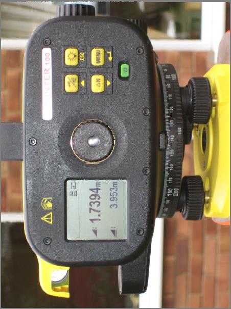
13 Level Monitoring 13
14 Traditional Frequency In cases where we suspect seasonal root induced clay shrinkage, the first reading would typically be taken at the onset of cracking between August and the end of September. The second reading will be taken 3 months later November through to mid-december. Further readings will only be taken in contentious or difficult cases, when it is likely they will be supported by site investigations. We need to ensure second visits are not over-looked. 14
15 Caution There is a potential for erroneous readings if we take the first and second readings prior to, and just after the peak when they could (in theory at least) be similar, suggesting the building to be stable, when in fact very large movements are taking place. Movement (mm) Movement Graph mths 1.5 mths MOVEMENT 3 mths 2.5 mths 2nd readings jun jul aug sep oct nov dec jan f eb mar apr may jun jul aug sep oct nov dec jan f eb mar apr may jun jul aug sep oct nov dec jan f eb mar apr may jun Timescale
16 Results Results require interpretation We are measuring deflection rather than crack damage Deflection Ratio - deflection/length = 0.2 to 0.4*10-3 before cracking develops (Burland and Wroth 1974) To more simple souls 10mm at foundations = 1mm crack. 16
17 Level Monitoring Level monitoring has been costly But it is a very powerful forensic tool. It provides a very clear picture of movement. 17


18 Example Huge Beech Tree Lots of damage We all agree it s the Beech. Whole house piling? 160,000? 18
19 Example The Level Survey What does it reveal? 19
20 Example Low Shrinkage Clay P.I s < 20% R.W. entering ground - not connected to system.? Crack movement of 1.4mm only - maximum. 20
21 Another Example 3D Presentation - Over Time No expensive deep datum just relative movement Station mm Station mm Station 1-6.7mm Station mm Station mm Station mm Station mm (extrapolated) Station mm Station mm 4th October nd September 1998 Station mm (extrapolated) Station mm 21
22 Another Example No expensive deep datum just relative movement Station mm Station mm If it goes down and then comes up Station 1-6.7mm Station mm Station mm Station mm Station mm (extrapolated) Station mm Station mm 4th October nd September 1998 Station mm (extrapolated) Station mm 22
23 Another Example No expensive deep datum just relative movement Station mm Station mm It is vegetation - clay shrinkage Station 1-6.7mm Station mm Station mm Station mm Station mm (extrapolated) Station mm Station mm 4th October nd September 1998 Station mm (extrapolated) Station mm 23
24 Another Example No expensive deep datum just relative movement Station mm Station mm Station 1-6.7mm Station mm Station mm Station mm Station mm (extrapolated) Station mm Station mm 4th October nd September 1998 Station mm (extrapolated) Station mm 24
25 Another Example No expensive deep datum just relative movement Station mm Station mm If it keeps going down, it s poor ground/water Station 1-6.7mm Station mm Station mm Station mm Station mm (extrapolated) Station mm Station mm 4th October nd September 1998 Station mm (extrapolated) Station mm 25
26 Another Example If it keeps going down, it s poor ground/water No expensive deep datum just relative movement Station mm Station mm Station 1-6.7mm Station mm Station mm Station mm Station mm (extrapolated) Station mm Station mm 4th October nd September 1998 Station mm (extrapolated) Station mm 26
27 Another Example If it keeps going down, it s poor ground/water No expensive deep datum just relative movement Station mm Station mm Station 1-6.7mm Station mm Station mm Station mm Station mm (extrapolated) Station mm Station mm 4th October nd September 1998 Station mm (extrapolated) Station mm 27
28 Results Results require interpretation We are measuring deflection rather than crack damage Deflection Ratio - deflection/length = 0.2 to 0.4*10-3 before cracking develops (Burland and Wroth 1974) To more simple souls 10mm at foundations = 1mm crack 28
29 Distortion Surveys 29

30 Example Cliff Cottage 30
31 Cliff Cottage 31
32 Cliff Cottage 32

33 How do we meet the challenges Innovation Education Collaborative working 33

34 Innovation - Remote monitoring Movement Graph mths 1.5 mths MOVEMENT Movement (mm) mths 2.5 mths 2nd readings jun jul aug sep oct nov dec jan feb mar apr may jun jul aug sep oct nov dec jan feb mar apr may jun jul aug sep oct nov dec jan feb mar apr may jun Timescale Speed, don t miss the peak readings But can it compete on cost? 34


")
35 The Power of Real Time Data Clay Shrinkage Seasonal Movement Opening (Summer) Closure Closure (Winter) Kent 35
36 Site Plan-Landslip 36
37 Plan of monitoring Locations 37

38 Crack Damage - Landslip 38


39 Crack Damage - Landslip 39
40 Landslip Case Remote monitoring 40


41 Tilt Sensors 3.30pm, Wednesday, 20th April, the Ash tree made the house move. 41
 sensor technology.")
42 Level and Time Domain Reflectometry (TDR) Dielectric Sensors SP Monitoring Services have been working closely with the clay research group to evaluate Level and TDR (which measures moisture content in the ground) sensor technology. 42
43 Remote - The Benefits! Sensor technology enables an early warning system of movement Reduced touch claim handling Accurate reporting and less opportunities for human error Web accessible by all interested parties in the claim process Fewer site visits - less disturbance to Policyholder Greater capability to handle increased volumes.? Tool to validate and compliment desk top risk assessment models Pre-claim applications 43
44 Collaboration Needs to be an industry wide agreement Subsidence Forum BRE CILA RICS 44
GAMINGRE 8/1/ of 7
 FYE 09/30/92 JULY 92 0.00 254,550.00 0.00 0 0 0 0 0 0 0 0 0 254,550.00 0.00 0.00 0.00 0.00 254,550.00 AUG 10,616,710.31 5,299.95 845,656.83 84,565.68 61,084.86 23,480.82 339,734.73 135,893.89 67,946.95
Computing & Telecommunications Services
 Computing & Telecommunications Services Monthly Report September 214 CaTS Help Desk (937) 775-4827 1-888-775-4827 25 Library Annex helpdesk@wright.edu www.wright.edu/cats/ Table of Contents HEAT Ticket
WHEN IS IT EVER GOING TO RAIN? Table of Average Annual Rainfall and Rainfall For Selected Arizona Cities
 WHEN IS IT EVER GOING TO RAIN? Table of Average Annual Rainfall and 2001-2002 Rainfall For Selected Arizona Cities Phoenix Tucson Flagstaff Avg. 2001-2002 Avg. 2001-2002 Avg. 2001-2002 October 0.7 0.0
Computing & Telecommunications Services Monthly Report January CaTS Help Desk. Wright State University (937)
") January 215 Monthly Report Computing & Telecommunications Services Monthly Report January 215 CaTS Help Desk (937) 775-4827 1-888-775-4827 25 Library Annex helpdesk@wright.edu www.wright.edu/cats/ Last
January 215 Monthly Report Computing & Telecommunications Services Monthly Report January 215 CaTS Help Desk (937) 775-4827 1-888-775-4827 25 Library Annex helpdesk@wright.edu www.wright.edu/cats/ Last
2019 Settlement Calendar for ASX Cash Market Products. ASX Settlement
 2019 Settlement Calendar for ASX Cash Market Products ASX Settlement Settlement Calendar for ASX Cash Market Products 1 ASX Settlement Pty Limited (ASX Settlement) operates a trade date plus two Business
Scarborough Tide Gauge
 Tide Gauge Location OS: 504898E 488622N WGS84: Latitude: 54 16' 56.990"N Longitude: 00 23' 25.0279"W Instrument Valeport 740 (Druck Pressure Transducer) Benchmarks Benchmark Description TGBM = 4.18m above
ENGINE SERIAL NUMBERS
 ENGINE SERIAL NUMBERS The engine number was also the serial number of the car. Engines were numbered when they were completed, and for the most part went into a chassis within a day or so. However, some
2017 Settlement Calendar for ASX Cash Market Products ASX SETTLEMENT
 2017 Settlement Calendar for ASX Cash Market Products ASX SETTLEMENT Settlement Calendar for ASX Cash Market Products 1 ASX Settlement Pty Limited (ASX Settlement) operates a trade date plus two Business
P7: Limiting Factors in Ecosystems
 P7: Limiting Factors in Ecosystems Purpose To understand that physical factors temperature and precipitation limit the growth of vegetative ecosystems Overview Students correlate graphs of vegetation vigor
ISO Lead Auditor Lean Six Sigma PMP Business Process Improvement Enterprise Risk Management IT Sales Training
 Training Calendar 2014 Public s (ISO LSS PMP BPI ERM IT Sales Training) (ISO, LSS, PMP, BPI, ERM, IT, Sales Public s) 1 Schedule Registration JANUARY ) FEBRUARY 2 days 26 JAN 27 JAN 3 days 28 JAN 30 JAN
ISO Lead Auditor Lean Six Sigma PMP Business Process Improvement Enterprise Risk Management IT Sales Training
 Training Calendar 2014 Public s (ISO LSS PMP BPI ERM IT Sales Training) (ISO, LSS, PMP, BPI, ERM, IT, Sales Public s) 1 Schedule Registration JANUARY IMS ) FEBRUARY 2 days 26 JAN 27 JAN 3 days 28 JAN 30
ISO Lead Auditor Lean Six Sigma PMP Business Process Improvement Enterprise Risk Management IT Sales Training
 Training Calendar 2014 Public s (ISO LSS PMP BPI ERM IT Sales Training) www.excelledia.com (ISO, LSS, PMP, BPI, ERM, IT, Sales Public s) 1 Schedule Registration JANUARY FEBRUARY 2 days 26 JAN 27 JAN 3
Published by ASX Settlement Pty Limited A.B.N Settlement Calendar for ASX Cash Market Products
 Published by Pty Limited A.B.N. 49 008 504 532 2012 Calendar for Cash Market Products Calendar for Cash Market Products¹ Pty Limited ( ) operates a trade date plus three Business (T+3) settlement discipline
Location. Datum. Survey. information. Etrometa. Step Gauge. Description. relative to Herne Bay is -2.72m. The site new level.
 Tide Gauge Location OS: 616895E 169377N WGS84: Latitude: 51 o 22.919196 N Longitude: 01 o 6.9335907 E Instrument Type Etrometa Step Gauge Benchmarks Benchmark TGBM = 5.524m above Ordnance Datum Newlyn
2018 Annual Review of Availability Assessment Hours
 2018 Annual Review of Availability Assessment Hours Amber Motley Manager, Short Term Forecasting Clyde Loutan Principal, Renewable Energy Integration Karl Meeusen Senior Advisor, Infrastructure & Regulatory
MISSION DEBRIEFING: Teacher Guide
 Activity 2: It s Raining Again?! Using real data from one particular location, students will interpret a graph that relates rainfall to the number of cases of malaria. Background The relationship between
Mountain View Community Shuttle Monthly Operations Report
 Mountain View Community Shuttle Monthly Operations Report December 6, 2018 Contents Passengers per Day, Table...- 3 - Passengers per Day, Chart...- 3 - Ridership Year-To-Date...- 4 - Average Daily Ridership
Interannual variation of MODIS NDVI in Lake Taihu and its relation to climate in submerged macrophyte region
 Yale-NUIST Center on Atmospheric Environment Interannual variation of MODIS NDVI in Lake Taihu and its relation to climate in submerged macrophyte region ZhangZhen 2015.07.10 1 Outline Introduction Data
YACT (Yet Another Climate Tool)? The SPI Explorer
? The SPI Explorer") YACT (Yet Another Climate Tool)? The SPI Explorer Mike Crimmins Assoc. Professor/Extension Specialist Dept. of Soil, Water, & Environmental Science The University of Arizona Yes, another climate tool for
YACT (Yet Another Climate Tool)? The SPI Explorer Mike Crimmins Assoc. Professor/Extension Specialist Dept. of Soil, Water, & Environmental Science The University of Arizona Yes, another climate tool for
Location. Datum. Survey. information. Etrometa. Step Gauge. Description. relative to Herne Bay is -2.72m. The site new level.
 Tide Gauge Location OS: 616895E 169377N WGS84: Latitude: 51 o 22.919196 N Longitude: 01 o 6.9335907 E Instrument Type Etrometa Step Gauge Benchmarks Benchmark TGBM = 5.524m above Ordnance Datum Newlyn
Dates and Prices ICAEW - Manchester In Centre Programme Prices
 Dates and Prices ICAEW - Manchester - 2019 In Centre Programme Prices Certificate Level GBP ( ) Intensive Accounting 690 Assurance 615 Law 615 Business, Technology and Finance 615 Mangement Information
TILT, DAYLIGHT AND SEASONS WORKSHEET
 TILT, DAYLIGHT AND SEASONS WORKSHEET Activity Description: Students will use a data table to make a graph for the length of day and average high temperature in Utah. They will then answer questions based
P7.7 A CLIMATOLOGICAL STUDY OF CLOUD TO GROUND LIGHTNING STRIKES IN THE VICINITY OF KENNEDY SPACE CENTER, FLORIDA
 P7.7 A CLIMATOLOGICAL STUDY OF CLOUD TO GROUND LIGHTNING STRIKES IN THE VICINITY OF KENNEDY SPACE CENTER, FLORIDA K. Lee Burns* Raytheon, Huntsville, Alabama Ryan K. Decker NASA, Marshall Space Flight
Outage Coordination and Business Practices
 Outage Coordination and Business Practices 1 2007 Objectives What drove the need for developing a planning/coordination process. Why outage planning/coordination is crucial and important. Determining what
Astrological Calendar. for Central Time
 2014 for Central Time January 2014 Capricorn Compliments of: Clayten Tylor Esoteric Astrologer (604)331-0251 Jan 15, 2014 Full Moon 10:53:09 PM CST Jan 1, 2014 New Moon 05:15:21 AM CST January 2014 Sun
Jackson County 2013 Weather Data
 Jackson County 2013 Weather Data 61 Years of Weather Data Recorded at the UF/IFAS Marianna North Florida Research and Education Center Doug Mayo Jackson County Extension Director 1952-2008 Rainfall Data
Country Presentation-Nepal
 Country Presentation-Nepal Mt.Everest, Shiva Pd. Nepal, DHM South Asia Drought Monitor Workshop Dhaka Bangladesh 2 th April 215 Overview Brief Climatology Climate activities- DHM PPCR (Pilot Program for
Memo. I. Executive Summary. II. ALERT Data Source. III. General System-Wide Reporting Summary. Date: January 26, 2009 To: From: Subject:
 Memo Date: January 26, 2009 To: From: Subject: Kevin Stewart Markus Ritsch 2010 Annual Legacy ALERT Data Analysis Summary Report I. Executive Summary The Urban Drainage and Flood Control District (District)
Chiang Rai Province CC Threat overview AAS1109 Mekong ARCC
 Chiang Rai Province CC Threat overview AAS1109 Mekong ARCC This threat overview relies on projections of future climate change in the Mekong Basin for the period 2045-2069 compared to a baseline of 1980-2005.
PREDICTING SOIL SUCTION PROFILES USING PREVAILING WEATHER
 PREDICTING SOIL SUCTION PROFILES USING PREVAILING WEATHER Ronald F. Reed, P.E. Member, ASCE rreed@reed-engineering.com Reed Engineering Group, Ltd. 2424 Stutz, Suite 4 Dallas, Texas 723 214-3-6 Abstract
Public Library Use and Economic Hard Times: Analysis of Recent Data
 Public Library Use and Economic Hard Times: Analysis of Recent Data A Report Prepared for The American Library Association by The Library Research Center University of Illinois at Urbana Champaign April
DAILY QUESTIONS 28 TH JUNE 18 REASONING - CALENDAR
 DAILY QUESTIONS 28 TH JUNE 18 REASONING - CALENDAR LEAP AND NON-LEAP YEAR *A non-leap year has 365 days whereas a leap year has 366 days. (as February has 29 days). *Every year which is divisible by 4
Calculations Equation of Time. EQUATION OF TIME = apparent solar time - mean solar time
 Calculations Equation of Time APPARENT SOLAR TIME is the time that is shown on sundials. A MEAN SOLAR DAY is a constant 24 hours every day of the year. Apparent solar days are measured from noon one day
GTR # VLTs GTR/VLT/Day %Δ:
 MARYLAND CASINOS: MONTHLY REVENUES TOTAL REVENUE, GROSS TERMINAL REVENUE, WIN/UNIT/DAY, TABLE DATA, AND MARKET SHARE CENTER FOR GAMING RESEARCH, DECEMBER 2017 Executive Summary Since its 2010 casino debut,
DOZENALS. A project promoting base 12 counting and measuring. Ideas and designs by DSA member (#342) and board member, Timothy F. Travis.
 and board member, Timothy F. Travis.") R AENBO DOZENALS A project promoting base 12 counting and measuring. Ideas and designs by DSA member (#342) and board member Timothy F. Travis. I became aware as a teenager of base twelve numbering from
R AENBO DOZENALS A project promoting base 12 counting and measuring. Ideas and designs by DSA member (#342) and board member Timothy F. Travis. I became aware as a teenager of base twelve numbering from
Changing Hydrology under a Changing Climate for a Coastal Plain Watershed
 Changing Hydrology under a Changing Climate for a Coastal Plain Watershed David Bosch USDA-ARS, Tifton, GA Jeff Arnold ARS Temple, TX and Peter Allen Baylor University, TX SEWRU Objectives 1. Project changes
Average 175, , , , , , ,046 YTD Total 1,098,649 1,509,593 1,868,795 1,418, ,169 1,977,225 2,065,321
 AGRICULTURE 01-Agriculture JUL 2,944-4,465 1,783-146 102 AUG 2,753 6,497 5,321 1,233 1,678 744 1,469 SEP - 4,274 4,183 1,596 - - 238 OCT 2,694 - - 1,032 340-276 NOV 1,979-5,822 637 3,221 1,923 1,532 DEC
Average 175, , , , , , ,940 YTD Total 944,460 1,284,944 1,635,177 1,183, ,954 1,744,134 1,565,640
 AGRICULTURE 01-Agriculture JUL 2,944-4,465 1,783-146 102 AUG 2,753 6,497 5,321 1,233 1,678 744 1,469 SEP - 4,274 4,183 1,596 - - 238 OCT 2,694 - - 1,032 340-276 NOV 1,979-5,822 637 3,221 1,923 1,532 DEC
Three main areas of work:
 Task 2: Climate Information 1 Task 2: Climate Information Three main areas of work: Collect historical and projected weather and climate data Conduct storm surge and wave modeling, sea-level rise (SLR)
Champaign-Urbana 2001 Annual Weather Summary
 Champaign-Urbana 2001 Annual Weather Summary ILLINOIS STATE WATER SURVEY 2204 Griffith Dr. Champaign, IL 61820 wxobsrvr@sws.uiuc.edu Maria Peters, Weather Observer January: After a cold and snowy December,
Minnesota s Climatic Conditions, Outlook, and Impacts on Agriculture. Today. 1. The weather and climate of 2017 to date
 Minnesota s Climatic Conditions, Outlook, and Impacts on Agriculture Kenny Blumenfeld, State Climatology Office Crop Insurance Conference, Sep 13, 2017 Today 1. The weather and climate of 2017 to date
Electricity Balancing System (EBS) Update. Philip Johnson Electricity Transition Manager, Business Change
 Update. Philip Johnson Electricity Transition Manager, Business Change") Electricity Balancing System (EBS) Update Philip Johnson Electricity Transition Manager, Business Change What s being changed and why? The BM system is for managing frequency and power flow in real time.
Electricity Balancing System (EBS) Update Philip Johnson Electricity Transition Manager, Business Change What s being changed and why? The BM system is for managing frequency and power flow in real time.
Determine the trend for time series data
 Extra Online Questions Determine the trend for time series data Covers AS 90641 (Statistics and Modelling 3.1) Scholarship Statistics and Modelling Chapter 1 Essent ial exam notes Time series 1. The value
DROUGHT INDICES BEING USED FOR THE GREATER HORN OF AFRICA (GHA)
") DROUGHT INDICES BEING USED FOR THE GREATER HORN OF AFRICA (GHA) Christopher Oludhe IGAD Climate Prediction and Applications Centre (ICPAC) Inter-Regional Workshop on Indices and Early Warning Systems for
DROUGHT INDICES BEING USED FOR THE GREATER HORN OF AFRICA (GHA) Christopher Oludhe IGAD Climate Prediction and Applications Centre (ICPAC) Inter-Regional Workshop on Indices and Early Warning Systems for
8.5. Modelling Data with Sinusoidal Functions. INVESTIGATE the Math
 8.5 Modelling Data with Sinusoidal Functions GOAL Determine the sinusoidal function that best models a set of data, and use your model to solve a problem. INVESTIGATE the Math Kelly lives in Winnipeg,
Technical note on seasonal adjustment for M0
 Technical note on seasonal adjustment for M0 July 1, 2013 Contents 1 M0 2 2 Steps in the seasonal adjustment procedure 3 2.1 Pre-adjustment analysis............................... 3 2.2 Seasonal adjustment.................................
PRELIMINARY DRAFT FOR DISCUSSION PURPOSES
 Memorandum To: David Thompson From: John Haapala CC: Dan McDonald Bob Montgomery Date: February 24, 2003 File #: 1003551 Re: Lake Wenatchee Historic Water Levels, Operation Model, and Flood Operation This
Name of business: Food Control Plan Diary 2017 Supplementary Records Hot-Hold
 Name of business: Food Control Plan Diary 2017 Supplementary Records Hot-Hold Th those s uitable for small to medium food businesses limited s Helpful Tips - Checking Food Temperatures Here are a few
EBS IT Meeting July 2016
 EBS IT Meeting 18 19 July 2016 Conference Call Details Conference call: UK Numbers Tel: 0808 238 9819 or Tel: 0207 950 1251 Participant code: 4834 7876... Join online meeting https://meet.nationalgrid.com/antonio.delcastillozas/hq507d31
Introduction to Forecasting
 Introduction to Forecasting Introduction to Forecasting Predicting the future Not an exact science but instead consists of a set of statistical tools and techniques that are supported by human judgment
CWV Review London Weather Station Move
 CWV Review London Weather Station Move 6th November 26 Demand Estimation Sub-Committee Background The current composite weather variables (CWVs) for North Thames (NT), Eastern (EA) and South Eastern (SE)
Life Cycle of Convective Systems over Western Colombia
 Life Cycle of Convective Systems over Western Colombia Meiry Sakamoto Uiversidade de São Paulo, São Paulo, Brazil Colombia Life Cycle of Convective Systems over Western Colombia Convective System (CS)
Practice Test Chapter 8 Sinusoidal Functions
 FOM 12 Practice Test Chapter 8 Sinusoidal Functions Name: Multiple Choice Identify the choice that best completes the statement or answers the question. Block: _ 1. Convert 120 into radians. A. 2" 3 B.
DROUGHT IN MAINLAND PORTUGAL
 DROUGHT IN MAINLAND Ministério da Ciência, Tecnologia e Ensino Superior Instituto de Meteorologia, I. P. Rua C Aeroporto de Lisboa Tel.: (351) 21 844 7000 e-mail:informacoes@meteo.pt 1749-077 Lisboa Portugal
Saudi Arabia. July present. Desert Locust Information Service FAO, Rome Red Sea coast outbreak
 Saudi Arabia July 2016 - present coast outbreak Desert Locust Information Service FAO, Rome www.fao.org/ag/locusts Keith Cressman (Senior Locust Forecasting Officer) updated: 24 January 2017 undetected
Safety effects of lower speed limits during winter months
 Safety effects of lower speed limits during winter months Jaakko Klang Traffic Safety Engineer Centres for Economic Development, Transport and the Environment Finland 13.9.2018 1 1. Finland 13.9.2018 2
STATISTICAL FORECASTING and SEASONALITY (M. E. Ippolito; )
") STATISTICAL FORECASTING and SEASONALITY (M. E. Ippolito; 10-6-13) PART I OVERVIEW The following discussion expands upon exponential smoothing and seasonality as presented in Chapter 11, Forecasting, in
STATISTICAL FORECASTING and SEASONALITY (M. E. Ippolito; 10-6-13) PART I OVERVIEW The following discussion expands upon exponential smoothing and seasonality as presented in Chapter 11, Forecasting, in
Salem Economic Outlook
 Salem Economic Outlook November 2012 Tim Duy, PHD Prepared for the Salem City Council November 7, 2012 Roadmap US Economic Update Slow and steady Positives: Housing/monetary policy Negatives: Rest of world/fiscal
AREP GAW. AQ Forecasting
 AQ Forecasting What Are We Forecasting Averaging Time (3 of 3) PM10 Daily Maximum Values, 2001 Santiago, Chile (MACAM stations) 300 Level 2 Pre-Emergency Level 1 Alert 200 Air Quality Standard 150 100
Agricultural Science Climatology Semester 2, Anne Green / Richard Thompson
 Agricultural Science Climatology Semester 2, 2006 Anne Green / Richard Thompson http://www.physics.usyd.edu.au/ag/agschome.htm Course Coordinator: Mike Wheatland Course Goals Evaluate & interpret information,
Combining sensor and forecast information to aid decision making: real-time determination of hydrological peat fire risk in Kalimantan
 Combining sensor and forecast information to aid decision making: real-time determination of hydrological peat fire risk in Kalimantan Jaap Schellekens Based on work by: Aljosja Hooijer, Ronald Vernimmen,
2008 Growing Season. Niagara Region
 28 Growing Season Niagara Region Weather INnovations Staff November 14, 28 Overview The start of the 28 growing season looked promising. After an extremely dry 27 growing season, soil moisture levels had
2003 Water Year Wrap-Up and Look Ahead
 2003 Water Year Wrap-Up and Look Ahead Nolan Doesken Colorado Climate Center Prepared by Odie Bliss http://ccc.atmos.colostate.edu Colorado Average Annual Precipitation Map South Platte Average Precipitation
Responsive Traffic Management Through Short-Term Weather and Collision Prediction
 Responsive Traffic Management Through Short-Term Weather and Collision Prediction Presenter: Stevanus A. Tjandra, Ph.D. City of Edmonton Office of Traffic Safety (OTS) Co-authors: Yongsheng Chen, Ph.D.,
Winter Season Resource Adequacy Analysis Status Report
 Winter Season Resource Adequacy Analysis Status Report Tom Falin Director Resource Adequacy Planning Markets & Reliability Committee October 26, 2017 Winter Risk Winter Season Resource Adequacy and Capacity
Wind Resource Data Summary Cotal Area, Guam Data Summary and Transmittal for December 2011
 Wind Resource Data Summary Cotal Area, Guam Data Summary and Transmittal for December 2011 Prepared for: GHD Inc. 194 Hernan Cortez Avenue 2nd Floor, Ste. 203 Hagatna, Guam 96910 January 2012 DNV Renewables
SYSTEM BRIEF DAILY SUMMARY
 SYSTEM BRIEF DAILY SUMMARY * ANNUAL MaxTemp NEL (MWH) Hr Ending Hr Ending LOAD (PEAK HOURS 7:00 AM TO 10:00 PM MON-SAT) ENERGY (MWH) INCREMENTAL COST DAY DATE Civic TOTAL MAXIMUM @Max MINIMUM @Min FACTOR
July 2017 LOGISTICAL HARMONY
 Li s&staging(wpedestriansidewalkprot.) (4/18/through7/18/2017) July2017 101BelvidereEastFaçadeWorkPipeStaging (4/18/through7/18/2017) 101BelvidereEastFaçadeWork (through8/31/2017) Legend RampaccesstoTMCX
Funding provided by NOAA Sectoral Applications Research Project CLIMATE. Basic Climatology Colorado Climate Center
 Funding provided by NOAA Sectoral Applications Research Project CLIMATE Basic Climatology Colorado Climate Center Remember These? Factor 1: Our Energy Source Factor 2: Revolution & Tilt Factor 3: Rotation!
CIMA Professional
 CIMA Professional 201819 Birmingham Interactive Timetable Version 3.1 Information last updated 12/10/18 Please note: Information and dates in this timetable are subject to change. A better way of learning
CIMA Professional
 CIMA Professional 201819 Manchester Interactive Timetable Version 3.1 Information last updated 12/10/18 Please note: Information and dates in this timetable are subject to change. A better way of learning
The Climate of Marshall County
 The Climate of Marshall County Marshall County is part of the Crosstimbers. This region is a transition region from the Central Great Plains to the more irregular terrain of southeastern Oklahoma. Average
Suppression of colonies of Reticulitermes spp. using the Sentricon termite colony elimination system: : A case study in Chatsworth, CA
 Suppression of colonies of Reticulitermes spp. using the Sentricon termite colony elimination system: : A case study in Chatsworth, CA Gail M. Getty, MS, Chris Solek, MS, Ron 1 1 Sbragia, Ph.D., Michael
Analysing The Temporal Pattern Of Crime Hotspots In South Yorkshire, United Kingdom
 Advances in Social Sciences Research Journal Vol.5, No.6 Publication Date: June. 25, 218 DoI:1.14738/assrj.56.4822. Abdullahi, H., & Abbas, I. I. (218). Analysing The Temporal Pattern Of Crime Hotspots
Public Disclosure Copy. Implementation Status & Results Report REVITALIZING EDUCATION DEVELOPMENT IN SIERRA LEONE (P133070)
") Public Disclosure Authorized AFRICA Sierra Leone Education Global Practice Recipient Executed Activities Investment Project Financing FY 2015 Seq No: 4 ARCHIVED on 27-Jun-2016 ISR24052 Implementing Agencies:
Public Disclosure Authorized AFRICA Sierra Leone Education Global Practice Recipient Executed Activities Investment Project Financing FY 2015 Seq No: 4 ARCHIVED on 27-Jun-2016 ISR24052 Implementing Agencies:
Constructing a typical meteorological year -TMY for Voinesti fruit trees region and the effects of global warming on the orchard ecosystem
 Constructing a typical meteorological year -TMY for Voinesti fruit trees region and the effects of global warming on the orchard ecosystem ARMEANU ILEANA*, STĂNICĂ FLORIN**, PETREHUS VIOREL*** *University
Highlights of the 2006 Water Year in Colorado
 Highlights of the 2006 Water Year in Colorado Nolan Doesken, State Climatologist Atmospheric Science Department Colorado State University http://ccc.atmos.colostate.edu Presented to 61 st Annual Meeting
Public Disclosure Copy
 EUROPE AND CENTRAL ASIA Bulgaria Water Global Practice IBRD/IDA Specific Investment Loan FY 2010 Seq No: 14 ARCHIVED on 07-Feb-2016 ISR22610 Implementing Agencies: Ministry of Regional Development and
The World Bank Caribbean Regional Communications Infrastructure Program (P114963)
") Public Disclosure Authorized LATIN AMERICA AND CARIBBEAN Caribbean Transport & ICT Global Practice IBRD/IDA Adaptable Program Loan FY 2012 Seq No: 9 ARCHIVED on 25-Jan-2017 ISR26209 Implementing Agencies:
Public Disclosure Authorized LATIN AMERICA AND CARIBBEAN Caribbean Transport & ICT Global Practice IBRD/IDA Adaptable Program Loan FY 2012 Seq No: 9 ARCHIVED on 25-Jan-2017 ISR26209 Implementing Agencies:
Earth Motions Packet 14
 Earth Motions Packet 14 Your Name Group Members Score Minutes Standard 4 Key Idea 1 Performance Indicator 1.1 Explain complex phenomena, such as tides, variations in day length, solar insolation, apparent
The Copernicus Climate Change (C3) service: State of play
 service: State of play") Enterprise and Industry The Copernicus Climate Change (C3) service: State of play B. Pinty (a) & J-N. Thépaut (b) (a) Copernicus G.2 unit (b) ECMWF CCI October2014 Legal frame & MS consultations Publica6on
Enterprise and Industry The Copernicus Climate Change (C3) service: State of play B. Pinty (a) & J-N. Thépaut (b) (a) Copernicus G.2 unit (b) ECMWF CCI October2014 Legal frame & MS consultations Publica6on
EVALUATION OF ALGORITHM PERFORMANCE 2012/13 GAS YEAR SCALING FACTOR AND WEATHER CORRECTION FACTOR
 EVALUATION OF ALGORITHM PERFORMANCE /3 GAS YEAR SCALING FACTOR AND WEATHER CORRECTION FACTOR. Background The annual gas year algorithm performance evaluation normally considers three sources of information
The Climate of Pontotoc County
 The Climate of Pontotoc County Pontotoc County is part of the Crosstimbers. This region is a transition region from the Central Great Plains to the more irregular terrain of southeast Oklahoma. Average
What is happening to the Jamaican climate?
 What is happening to the Jamaican climate? Climate Change and Jamaica: Why worry? Climate Studies Group, Mona (CSGM) Department of Physics University of the West Indies, Mona Part 1 RAIN A FALL, BUT DUTTY
OVERVIEW OF IMPROVED USE OF RS INDICATORS AT INAM. Domingos Mosquito Patricio
 OVERVIEW OF IMPROVED USE OF RS INDICATORS AT INAM Domingos Mosquito Patricio domingos.mosquito@gmail.com Introduction to Mozambique /INAM Introduction to AGRICAB/SPIRITS Objectives Material & Methods Results
Champaign-Urbana 2000 Annual Weather Summary
 Champaign-Urbana 2000 Annual Weather Summary ILLINOIS STATE WATER SURVEY 2204 Griffith Dr. Champaign, IL 61820 wxobsrvr@sws.uiuc.edu Maria Peters, Weather Observer January: January started on a mild note,
Proposal to limit Namakan Lake to 1970 Upper Rule Curve for remainder of summer
 July 7, 214 Subject: Proposal to limit Namakan Lake to 197 Upper Rule Curve for remainder of summer Background: Flooding in 214 has resulted in the highest water levels on Namakan Lake since 1968, and
WhatsApp, Sun, Equinox, Dehydration...
 WhatsApp, Sun, Equinox, Dehydration... Umesh P N May 22, 2018 1 Background The following message takes its rounds in whatsapp now: Drink more water for the next seven days (May 22-28) due to EQUINOX (Astronomical
ACCA Interactive Timetable & Fees
 ACCA Interactive Timetable & Fees 2018/19 Professional Version 2.1 Information last updated 01 November 2018 Please note: Information and dates in this timetable are subject to change. A better way of
Implementation Status & Results Burkina Faso TRANSPORT SECTOR PROJECT (P074030)
") losure Authorized Public Disclosure Authorized Public Disclosure Authorized Public Disclosure Authorized Implementation Status & Results Burkina Faso TRANSPORT SECTOR PROJECT (P074030) Operation Name:
losure Authorized Public Disclosure Authorized Public Disclosure Authorized Public Disclosure Authorized Implementation Status & Results Burkina Faso TRANSPORT SECTOR PROJECT (P074030) Operation Name:
Current and Future Impacts of Wildfires on PM 2.5, Health, and Policy in the Rocky Mountains
 Current and Future Impacts of Wildfires on PM 2.5, Health, and Policy in the Rocky Mountains Yang Liu, Ph.D. STAR Grants Kick-off Meeting Research Triangle Park, NC April 5, 2017 Motivation The Rocky Mountains
Effective Gross Revenue 3,335,005 3,130,591 3,320,552 3,338,276 3,467,475 3,606,962 3,509,653 3,981,103 3,984,065 4,147,197 4,300,790
 Schedule Of Prospective Cash Flow In Inflated Dollars for the Fiscal Year Beginning 1/1/2011 Potential Gross Revenue Base Rental Revenue $3,331,625 $3,318,220 $3,275,648 $3,270,394 $3,368,740 $3,482,312
Communicating Climate Change Consequences for Land Use
 Communicating Climate Change Consequences for Land Use Site: Prabost, Skye. Event: Kyle of Lochalsh, 28 th February 28 Further information: http://www.macaulay.ac.uk/ladss/comm_cc_consequences.html Who
The Climate of Kiowa County
 The Climate of Kiowa County Kiowa County is part of the Central Great Plains, encompassing some of the best agricultural land in Oklahoma. Average annual precipitation ranges from about 24 inches in northwestern
Monthly Magnetic Bulletin
 BRITISH GEOLOGICAL SURVEY Ascension Island Observatory Monthly Magnetic Bulletin December 2008 08/12/AS Crown copyright; Ordnance Survey ASCENSION ISLAND OBSERVATORY MAGNETIC DATA 1. Introduction Ascension
The Climate of Payne County
 The Climate of Payne County Payne County is part of the Central Great Plains in the west, encompassing some of the best agricultural land in Oklahoma. Payne County is also part of the Crosstimbers in the
The Climate of Texas County
 The Climate of Texas County Texas County is part of the Western High Plains in the north and west and the Southwestern Tablelands in the east. The Western High Plains are characterized by abundant cropland
CHAPTER-11 CLIMATE AND RAINFALL
 CHAPTER-11 CLIMATE AND RAINFALL 2.1 Climate Climate in a narrow sense is usually defined as the "average weather", or more rigorously, as the statistical description in terms of the mean and variability
Variability of Reference Evapotranspiration Across Nebraska
 Know how. Know now. EC733 Variability of Reference Evapotranspiration Across Nebraska Suat Irmak, Extension Soil and Water Resources and Irrigation Specialist Kari E. Skaggs, Research Associate, Biological
The Climate of Seminole County
 The Climate of Seminole County Seminole County is part of the Crosstimbers. This region is a transition region from the Central Great Plains to the more irregular terrain of southeastern Oklahoma. Average