REAL ESTATE AUCTION Saturday, April 14, 1:00pm
|
|
|
- Coleen Lester
- 5 years ago
- Views:
Transcription
 3.3+- Acres. A Private Wooded Site with Mature Timber. Hilltop Views.")


 Haines, Executor. DIRECTIONS: From Middleburg take Route 522 north/east. As you leave town turn right at Middleburg Rental Center onto Dock Hill Road.")
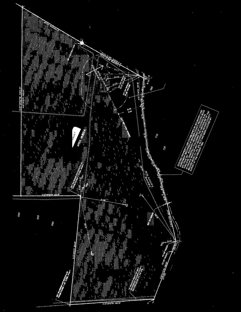
1 COMPLETE REAL ESTATE AUCTION Saturday, April 14, 1:00pm 147 Dock Hill Road, Middleburg PA ACRES OF PRIME COUNTRY REAL ESTATE 9 Parcels offered Individually, Any Combination, or in its Entirety Parcel 8: (known as Tract 2 of the Haines Subdivision) Acres. A Private Wooded Site with Mature Timber. Hilltop Views. Perc d Parcel 9: (known as Tract 1-B of the Haines Subdivision) Acres. The Acreage is approx. 90% Open & 10% Wooded. The Property has a Small Stream and Great Long Views. Perc d. Parcels 1-9 will be offered individually, any combination, or the entire property. Buy one or as many of these properties as you desire. All parcels are located within ¾ mile of the Midd-West Elementary, Middle, & High School. A Great Country Setting yet close to town. Join us for an Open House & Tour of the Property on Saturday, March 17 th from 1:00pm to 4:00pm, Friday, March 30 th from 1:00pm to 5:00pm, & Saturday, March 31 st from 1:00pm to 5:00pm. TERMS: 10% Down, Balance in 45 Days. No Buyer s Premium. Attorney: Tom Clark, Broker Participation Invited at 3%. SELLERS: The Estate of Lois Haines. Sue Gray, Executrix. Howard (Bucky) Haines, Executor. DIRECTIONS: From Middleburg take Route 522 north/east. As you leave town turn right at Middleburg Rental Center onto Dock Hill Road. Travel ¾ mile to auction on the right. Signs posted. SERVICE For photos and more information scan this QR Code with your smartphone. Parcel 1: (known as Lot 8 of the Haines Subdivision) Acres of Open Land. Nice Level Country Setting. Perc d. Parcel 2: (known as Lot 10 of the Haines Subdivision) Acres of Open Land. Nice Level Country Setting. Perc d. Parcel 3: (known as Lot 9 of the Haines Subdivision) Acres of Open Land. Nice Level Country Setting. Perc d. Parcel 4: (known as Lot 7 of the Haines Subdivision) Acres. Approx. 60% Wooded, 40% Open. A Private Country Setting with a Small Stream. Some Timber Value. Perc d. Parcel 5: (known as Tract 1-A of the Haines Subdivision) Acres. The Acreage is approx. 65% Open & 35% Wooded (has Mature Timber). A Great Mini-Farm for Horses or Cattle. Located on the Property is a Period Stone 2 Story Farm House with Living Room, Kitchen, Dining Room, & ½ Bath on the First Level and 3 Bedrooms & 1 Bath on the Second Level. The Home has an Enclosed Front Porch with Great Views of the Countryside, an Open Porch to the Rear of the Property, & a very quaint Stone & Frame Summer Kitchen retaining its Original Fireplace. This Parcel affords many possibilities for Permanent Home, Farmette with Horses, or Great Recreational Site as the Property has a Small Stream & Pond. Parcel 6: (known as Lot 6 of the Haines Subdivision) Acres. The Acreage is Level with Nice Views of the Countryside. Would make a Great Farmette or with Public Sewer the possibilities of Future Development. Perc d. Parcel 7: (known as Tract 1-C of the Haines Subdivision) Acres. The Acreage is approx. 80% Open & 20% Wooded (some Mature Timber). A Very Private Setting with Great Long Views of the Countryside. A Wonderful Property for Horses or Cattle with a Private Homesite overlooking the Schools & Mountains. A Must See. Great for Horseback Riding or Four-Wheeling. Perc d. KENNETH E. HASSINGER 330 Hassinger Way McClure, PA (570) : AU L NEIL A. COURTNEY 3442 Heister Valley Road Richfield, PA (570) : AU L
2 Information Packet Index For the Estate of Lois Haines, 147 Dock Hill Road, Middleburg PA Saturday, April 14 th, 2012 at 1:00pm Page 1: Flyer Page 2: Index Page 3: Key Map Page 4: Plat with Parcels Page 5: GIS Page 6: Parcel 1 Plat Page 7: Parcel 1 Legal Description Page 8: Parcel 1 Sewer Data Page 9: Parcel 2 Plat Page 10: Parcel 2 Legal Description Page 11 12: Parcel 2 Sewer Data Page 13: Parcel 3 Plat Page 14 15: Parcel 3 Legal Description Page 16: Parcel 3 Sewer Data Page 17: Plat Parcel 4 Page 18 19: Parcel 4 Legal Description Page 20: Parcel 4 Sewer Data Page 21: Parcel 4 Timber Evaluation Page 22: Parcel 5 Plat Page 23: Parcel 5 Photos of Home Page 24 26: Parcel 5 Legal Description Page 27: Parcel 5 Sewer Data Page 28: Page 29: Page 30: Page 31 32: Page 33: Page 34: Page 35 37: Page 38: Page 39: Page 40: Page 41 42: Page 43: Page 44: Page 45 48: Page 49: Page 50 51: Page 52: Page 53: Page 54 58: Page 59 61: Parcel 5 Timber Evaluation Parcel 6 Plat Parcel 6 Legal Description Parcel 6 Sewer Data Parcel 7 Plat Parcel 7 Long View Photos Parcel 7 Legal Description Parcel 7 Sewer Data Parcel 7 Timber Evaluation Parcel 8 Plat Parcel 8 Legal Description Parcel 8 Sewer Data Parcel 8 Timber Evaluation Reciprocal Agreement of Existing Rightof Way as Pertaining to Parcel 7 8 Parcel 9 Plat Parcel 9 Legal Description Parcel 9 Long View Photos Parcel 9 Sewer Data Stream Crossing Report Sample Terms & Conditions & Sales Agreement Disclaimer: The information contained herein is subject to verification by any parties relying on it. Although the Seller & Auctioneer have attempted to provide accurate information, neither the Seller nor the Auctioneers assume any liability for errors or omissions in the information provided both in the sales brochure or the informational packet. The terms of sale & sales agreement shall be the final & only agreement between the Buyer & Seller

3 KEY MAP DIAGRAM
4

5
6 AREA RESERVED FOR:ON LOT SEWAGE DISPOSAL SYSTEM. <-;1=7314"REBAI 30 50'53' - ~' 2,26' FROM FO 6"AXiLE,/;:".. /" // REFERENCE S WAGE PERMIT.' IL APPLICATION NO. 1'1-2. ", "i /.' ' RlW '.'-IH_ '1 ~" <l<) ' ~IJ"" (), ~ l n l" tjl ',..,(;r,~ 1 ' PliO;- I, CENI ERI A DI/IVn,./ FR.1/-fi ~ CO,v~;Tf{( TRI, 'GI./,...~ --.. '.~ ".".~-.. S 89~24'46"W '~89:B4;~---:--:'':'" " " -...~~...,. -P~----_.-- N 89" 4'46"E 309':84' '.", : '.. '.~. I Ace BUll ' ~ ~.. '.,.".... ".. ) 'c" < ". /. ~ ', '",>y -, ' ".~ '. --:-. _ l. -'. "-':--", '.,._:.-:-::-:..., '. -...: ~ l. / "--" ----,. I nmn
7 METES AND BOUNDS LEGAL DESCRIPTION LOT 8 FINAL SUBDIVISION PLAN For THE LOIS J. HAINES ESTATE Parcel 1 All that certain tract or parcel of land situate in the Township of Franklin, County of Snyder, Commonwealth of Pennsylvania, being more particularly bounded and described to wit: BEGINNING at a nail set in the approximate center of T-399, Dock Hill Road, located six tenths (0.6) of a mile southeast of the intersection with S.R. 0522, at the easternmost corner of Lot 5 of a previously approved plan of subdivision for the Lois J. Haines Estate, said beginning point being the northernmost corner of the herein described tract or parcel of land; THENCE South thirty eight (38) degrees twenty eight (28) minutes fifty one (51) seconds East, along the approximate centerline of T-399 and the southwest line of Lot 6 of the same plan of subdivision, a distance of two hundred forty six and forty nine hundredths (246.49) feet to a nail set in the approximate center of T-399 THENCE South fifty one (51) degrees thirty one (31) minutes nine (09) seconds West, along Lot 9 of the same plan of subdivision, through a ¾ diameter rebar set sixteen and fifty hundredths (16.50) feet on-line from the beginning of said course, a total distance of two hundred fifty six and thirty five hundredths (256.35) feet to a set ¾ diameter rebar; THENCE North thirty eight (38) degrees twenty eight (28) minutes fifty (50) seconds West, along the same, a distance of two hundred sixty two and twenty four hundredths (262.24) feet to a set ¾ diameter rebar on the south line of Lot 5; THENCE North fifty five (55) degrees two (02) minutes five (05) seconds East, along the south line of Lot 5, through a ¾ diameter rebar set sixteen and fifty three hundredths (16.53) feet online from the terminal end of said course, a total distance of two hundred fifty six and eighty three hundredths (256.83) feet to a nail set in the approximate center of T-399, the POINT OF BEGINNING. SAID tract or parcel of land containing one and four hundred ninety seven thousandths (1.497) acres of land gross area, more or less, and one and four hundred three thousandths (1.403) of an acre of land net area, more or less, as described on the Final Subdivision Plan for The Lois J. Haines Estate, prepared by Kreamer Survey Associates, Inc., dated August 31, 2011, revised October,
8 PARCEL 1
9 AREA RESERVED FOR:ON LOT SEWAGE DISPOSAL SYSTEM. <-;1=7314"REBAI 30 50'53' - ~' 2,26' FROM FO 6"AXiLE,/;:".. /" // REFERENCE S WAGE PERMIT.' IL APPLICATION NO. 1'1-2. ", "i /.' ' RlW '.'-IH_ '1 ~" <l<) ' ~IJ"" (), ~ l n l" tjl ',..,(;r,~ 1 ' PliO;- I, CENI ERI A DI/IVn,./ FR.1/-fi ~ CO,v~;Tf{( TRI, 'GI./,...~ --.. '.~ ".".~-.. S 89~24'46"W '~89:B4;~---:--:'':'" " " -...~~...,. -P~----_.-- N 89" 4'46"E 309':84' '.", : '.. '.~. I Ace BUll ' ~ ~.. '.,.".... ".. ) 'c" < ". /. ~ ', '",>y -, ' ".~ '. --:-. _ l. -'. "-':--", '.,._:.-:-::-:..., '. -...: ~ l. / "--" ----,. I nmn
10 METES AND BOUNDS LEGAL DESCRIPTION LOT 10 FINAL SUBDIVISION PLAN For THE LOIS J. HAINES ESTATE Parcel 2 All that certain tract or parcel of land situate in the Township of Franklin, County of Snyder, Commonwealth of Pennsylvania, being more particularly bounded and described to wit: BEGINNING at a nail set in the approximate center of T-399, Dock Hill Road, located approximately six tenths (0.6) of a mile southeast of the intersection with S.R. 0522, at the easternmost corner of Lot 7 of the same plan of subdivision, said beginning point being the northernmost corner of the herein described tract or parcel of land; THENCE South thirty eight (38) degrees twenty eight (28) minutes fifty one (51) seconds East, along the centerline of T-399 and the southwest line of Lot 6 and the Residual-Lot 1 of the same plan of subdivision, a distance of two hundred thirty and zero hundredths (230.00) feet to a nail set in the approximate center of T-399 THENCE South fifty one (51) degrees thirty one (31) minutes nine (09) seconds West, along Residual Lot 1, through a ¾ diameter rebar set sixteen and fifty hundredths (16.50) feet on-line from the beginning of said course, a total distance of three hundred sixty one and fifty one hundredths (361.51) feet to a set ¾ diameter rebar; THENCE North thirty eight (38) degrees twenty eight (28) minutes fifty one (51) seconds West, along the line of Lot 7, a distance of two hundred thirty and zero hundredths (230.00) feet to a set ¾ diameter rebar; THENCE North fifty one (51) degrees thirty one (31) minutes nine (09) seconds East, along the same, through a ¾ diameter rebar set sixteen and fifty hundredths (16.50) feet on-line from the terminal end of said course, a total distance of three hundred sixty one and fifty hundredths (361.50) feet to a nail set in the approximate center of T-399, the POINT OF BEGINNING. SAID tract or parcel of land containing one and nine hundred nine thousandths (1.909) acres of land gross area, more or less, and one and eight hundred twenty two thousandths (1.822) of an acre of land net area, more or less, as described on the Final Subdivision Plan for The Lois J. Haines Estate, prepared by Kreamer Survey Associates, Inc., dated August 31, 2011, revised October,
11 PARCEL 2
12 PARCEL 2
13 AREA RESERVED FOR:ON LOT SEWAGE DISPOSAL SYSTEM. <-;1=7314"REBAI 30 50'53' - ~' 2,26' FROM FO 6"AXiLE,/;:".. /" // REFERENCE S WAGE PERMIT.' IL APPLICATION NO. 1'1-2. ", "i /.' ' RlW '.'-IH_ '1 ~" <l<) ' ~IJ"" (), ~ l n l" tjl ',..,(;r,~ 1 ' PliO;- I, CENI ERI A DI/IVn,./ FR.1/-fi ~ CO,v~;Tf{( TRI, 'GI./,...~ --.. '.~ ".".~-.. S 89~24'46"W '~89:B4;~---:--:'':'" " " -...~~...,. -P~----_.-- N 89" 4'46"E 309':84' '.", : '.. '.~. I Ace BUll ' ~ ~.. '.,.".... ".. ) 'c" < ". /. ~ ', '",>y -, ' ".~ '. --:-. _ l. -'. "-':--", '.,._:.-:-::-:..., '. -...: ~ l. / "--" ----,. I nmn
14 METES AND BOUNDS LEGAL DESCRIPTION LOT 9 FINAL SUBDIVISION PLAN For THE LOIS J. HAINES ESTATE Parcel 3 All that certain tract or parcel of land situate in the Township of Franklin, County of Snyder, Commonwealth of Pennsylvania, being more particularly bounded and described to wit: BEGINNING at a nail set in the approximate center of T-399, Dock Hill Road, located approximately six tenths (0.6) of a mile southeast of the intersection with S.R. 0522, at the easternmost corner of Lot 8 of the same plan of subdivision, said beginning point being the northernmost corner of the herein described tract or parcel of land; THENCE South thirty eight (38) degrees twenty eight (28) minutes fifty one (51) seconds East, along the centerline of T-399 and the southwest line of Lot 6 of the same plan of subdivision, a distance of twenty five and zero hundredths (25.00) feet to a nail set in the approximate center of T-399 THENCE South fifty one (51) degrees thirty one (31) minutes nine (09) seconds West, along the line of Lot 7 of the same plan of subdivision, through a ¾ diameter rebar set sixteen and fifty hundredths (16.50) feet on-line from the beginning of said course, a total distance of four hundred fifteen and thirty nine hundredths (415.39) feet to a set ¾ diameter rebar; THENCE North sixty eight (68) degrees nineteen (19) minutes twenty four (24) seconds West, along the same, a distance of one hundred thirty five and fifty six hundredths (135.56) feet to a set ¾ diameter rebar; THENCE North thirty eight (38) degrees thirty six (36) minutes fifteen (15) seconds West, along the same, a distance of one hundred sixty and zero hundredths (160.00) feet to a set ¾ diameter rebar; THENCE North seventeen (17) degrees one (01) minutes twenty six (26) seconds East, along the same, a distance of thirty eight and twenty four hundredths (38.24) feet to a set ¾ diameter rebar at the southernmost corner of Lot 5 of a previously approved subdivision plan for the Lois J. Haines Estate; THENCE North fifty five (55) degrees two (02) minutes five (05) seconds East, along the south line of Lot 5, a distance of one hundred ninety five and seventy hundredths (195.70) feet to a set ¾ diameter rebar at the westernmost corner of Lot 8; THENCE South thirty eight (38) degrees twenty eight (28) minutes fifty (50) seconds East, along Lot 8, a distance of two hundred sixty two and twenty four hundredths (262.24) feet to a set ¾ diameter rebar at the southernmost corner of Lot 8; 1
15 THENCE North fifty one (51) degrees thirty one (31) minutes nine (09) seconds East, along the same, through a ¾ diameter rebar set sixteen and fifty hundredths (16.50) feet on-line from the terminal end of said course, a total distance of two hundred fifty six and thirty five hundredths (256.35) feet to a nail set in the approximate center of T-399, the POINT OF BEGINNING. SAID tract or parcel of land containing one and five hundred seventy eight thousandths (1.578) acres of land gross area, more or less, and one and five hundred sixty nine thousandths (1.569) of an acre of land net area, more or less, as described on the Final Subdivision Plan for The Lois J. Haines Estate, prepared by Kreamer Survey Associates, Inc., dated August 31, 2011, revised October,
16 PARCEL 3
RNER ''.. ' ~, _,.,~~,.:, ~ -# lf>i':~ 'lp0 ' pf'~o~ 1 l'i_p.ll-1 ~~0oO ' -t. v...r--~0 J-..,',.._. -...,... / ~ -z_ ~ ~ '6 '4.!z_ '\"-.~ ~~S'.")
'. ' 6'~;ii' '5 ~?~ ~, c<: y' \"'<\"', // '\",. -' \"0:?,.,.~/ \"}K.<?O> 1so / ' ' y,_,\" rnna' '4 I L\"'- HAINESESTA_TE. <,. \" \". ' ~ '\"\" ',., r, ~ c:&,.. GROSSAR.t569A...,,-- /. --.")
17 FD f 8~ ~~- '...- ' _...., ,-.f'r-"-,.., r--r- _,..._ '""" ::::::.. --=- - _.-/~ _... -~ '"// ""' - -- ',~o;;;;;;;.. -~.::::;. /j ~Lfirt'E'l~.9Qi.?.:.::.~. -~. FDfYB"REBARft.j INSTONES ~ 73 )RNER ''.. ' ~, _,.,~~,.:, ~ -# lf>i':~ 'lp0 ' pf'~o~ 1 l'i_p.ll-1 ~~0oO ' -t. v...r--~0 J-..,',.._. -...,... / ~ -z_ ~ ~ '6 '4.!z_ '"-.~ ~~S'.. '~ ' ' "- ' ',, ~~ ~~ 0)~ () ~ -:s:-.0 ~ '.....,. "' <?- q_ :. ~ --&. ~ ~- - f C> 5'11' REBAR- ~;... ~~ ' ~...._... '"'- ~: t. ~ j6"1b'3 "E _ ~( -,-z. '""' ' ~. ~~ "-,~ ":>-, ~ "-. ()'. ' 6'~;ii' '5 ~?~ ~, c<: y' "'<"', // '",. -' "0:?,.,.~/ "}K.<?O> 1so / ' ' y,_," rnna' '4 I L"'- HAINESESTA_TE. <,. " ". ' ~ '"" ',., r, ~ c:&,.. GROSSAR.t569A...,,-- /. --. ; Z'. "'~ ~.. ~ I-.""'-:" 00'.. ';'. '~ / r; "~/. I AREA RESERVED FOR ON-LOT. ~ ;:; _ SEWAGE DISPOSAL SYSTEM. ~ REFEFIENCE SEWAGE PERMIT APPLICATION NO 11-2 t:>' " <n C:S::o.;( o~~g;._j ~,...,co IJ.!J..,:o)o; ~~ititj &13~~.,;;;., ~~~~--.,. pr..u -.1 {!) <"" ~~ ' ~.,_ s. - ~' WOODED AREA. ~ /..._ ' NET AREA. r-- X, / ' 'y ~~-~ '.. '.', y ~ /,, ",_,/ """ ~.. /1 { / I I <;;,..1.//.. : 'fie / -...~.,<. / /....!:>.~ 'I"'S..( i / ~ ' "-. /... / " '.,_, - r-..._ <SiJ ~ - "' ~.._,_,_ ~<> --- -,.. "'~ - il. "'= , - (.:.._. "... ~- "'i... <?./',, ~~ ~ --.. " "~:,~ I -_' AREAS RESERVED FOR PRIMARY '~...;, ~Wv & REFLACEMENT ON-LOT SEWAGE ". j"-....:_:~0 h -... DISPOSAL SYSTEMS REFERENCE ~.,- '~. "- ~Vr. -.. SEWAGE PERMIT APPLICATIOII '"o' -~, ---!' '6~ -..:.:~Do.. - ' ' 50' MIN STREAM ENCROACHMENT SETBACK."-' ~0?, -~..-,.,. ' TYPICAL AL?_NG LENGTH OF STREAM. REF --.:; ~ r. v.,...,. >.,. -~-,.--,.., DEP CHAPTeR 105 FOR PERMIT/APPROVAL ~~... '- ""' REQUIREMENTS ' Q ") : _, II.,.P - uor ~ -~~ ~~~ 4W~.~4~ '""-: "".: ~ --- / ~.._'-'.'...'--t... ' -, "H,j ::-.. /./'~<:; - - ' y -..&~..~o''(fo '""' ' '--'~ ~- " /' "... t -...-'G-.:. _::::::.-....,'-.. ;J. I ---/ ~/ ""'.-,...,. -..._--.. :..:_: '"" --
18 METES AND BOUNDS LEGAL DESCRIPTION LOT 7 FINAL SUBDIVISION PLAN For THE LOIS J. HAINES ESTATE Parcel 4 All that certain tract or parcel of land situate in the Township of Franklin, County of Snyder, Commonwealth of Pennsylvania, being more particularly bounded and described to wit: BEGINNING at a nail set in the approximate center of T-399, Dock Hill Road, located approximately six tenths (0.6) of a mile southeast of the intersection with S.R. 0522, at the easternmost corner of Lot 9 of the same plan of subdivision, said beginning point being the northeast corner of the herein described tract or parcel of land; THENCE South thirty eight (38) degrees twenty eight (28) minutes fifty one (51) seconds East, along the approximate centerline of T-399, a distance of twenty five and zero hundredths (25.00) feet to a nail set in the same; THENCE South fifty one (51) degrees thirty one (31) minutes nine (09) seconds West, along the northwest line of Lot 10 of the same plan of subdivision, through a ¾ diameter rebar set sixteen and fifty hundredths (16.50) feet on-line from the beginning of said course, a total distance of three hundred sixty one and fifty hundredths (361.50) feet to a set ¾ diameter rebar at the westernmost corner of Lot 10; THENCE South thirty eight (38) degrees twenty eight (28) minutes fifty one (51) seconds East, along the southwest line of the same, a distance of two hundred thirty and zero hundredths (230.00) feet to a set ¾ diameter rebar on the north line of the Residual-Lot 1; THENCE South fifty one (51) degrees thirty one (31) minutes nine (09) seconds West, along the north line of the Residual Lot 1, a distance of fifty six and nineteen hundredths (56.19) feet to a set ¾ diameter rebar; THENCE South eighty nine (89) degrees twenty four (24) minutes forty six (46) seconds West, along the same, a distance of three hundred eighty nine and eighty four hundredths (389.84) feet to a set ¾ diameter rebar; THENCE South seventy six (76) degrees eighteen (18) minutes thirty six (36) seconds West, along the same, a distance of five hundred forty two and thirty hundredths (542.30) feet to a set ¾ diameter rebar on the east line of lands now or formerly of the Midd-West School District; THENCE North twenty six (26) degrees thirty one (31) minutes twenty eight (28) seconds West, along the east line of lands now or formerly of the Midd-West School District, through a 5/8 diameter rebar found twenty six and seventy three hundredths (26.73) feet on-line from the terminal end of said course, a total distance of five hundred sixty five and thirty eight hundredths (565.38) feet to a set ¾ diameter rebar; 1
19 THENCE North eighty nine (89) degrees twenty seven (27) minutes nineteen (19) seconds East, along the south line of the same, and along the south line of lands now or formerly of Roger T., Sr. & Shirley A. Long, a distance of five hundred four and twenty six hundredths (504.26) feet to a found 5/8" diameter rebar; THENCE North fifty six (56) degrees twenty eight (28) minutes seven (07) seconds East, along the south line of lands now or formerly of Roger T., Sr. & Shirley A. Long, a distance of two hundred fifty two and eight hundredths (252.08) feet to a set ¾ diameter rebar; THENCE South thirty eight (38) degrees twenty eight (28) minutes fifty one (51) seconds East, along the southwest line of lands now or formerly of Elwood E. & Rachael J. Kline, and along Lot 5 of a previously approved plan of subdivision, a distance of one hundred thirty three and ninety four hundredths (133.94) feet to a set ¾ diameter rebar at the northwest corner of Lot 9; THENCE South seventeen (17) degrees one (01) minute twenty six (26) seconds West, along Lot 9, a distance of thirty eight and twenty four hundredths (38.24) feet to a set ¾ diameter rebar; THENCE South thirty eight (38) degrees thirty six (36) minutes fifteen (15) seconds East, along the same, a distance of one hundred sixty and zero hundredths (160.00) feet to a set ¾ diameter rebar; THENCE South sixty eight (68) degrees nineteen (19) minutes twenty four (24) seconds East, along the same, a distance of one hundred thirty five and fifty six hundredths (135.56) feet to a set ¾ diameter rebar; THENCE North fifty one (51) degrees thirty one (31) minutes nine (09) seconds East, along the southeast line of the same, through a ¾ diameter rebar set sixteen and fifty hundredths (16.50) feet on-line from the terminal end of said course, a total distance of four hundred fifteen and thirty nine hundredths (415.39) feet to a nail set in the approximate center of T-399, the POINT OF BEGINNING. SAID tract or parcel of land containing nine and seven hundred nine thousandths (9.709) acres of land gross area, more or less, and nine and six hundred ninety nine thousandths (9.699) acres of land net area, more or less, as described on the Final Subdivision Plan for The Lois J. Haines Estate, prepared by Kreamer Survey Associates, Inc., dated August 31, 2011, revised October,
20 PARCEL 4
21 Haines Timber Estimate Parcel 4 SPECIES Tract Ave Intern. Scale % by Average "dia. "dia. "dia. "dia. "dia. "dia. "dia. "dia. "dia. "dia. "dia. "dia. "dia. "dia. "dia. Total # dbh Volume Volume Volume/tree ASH % 154 RED MAPLE % 126 SCARLET OAK % 263 ELM % 106 BLACK CHERRY % 92 BLACK WALNUT % 109 TOTALS Average diameter for tract is 16.9 "dbh. Average bd.ft. per Tree is: 155 Total # Trees: 59 Tot. Vol Total # Culls 7


22


23
24 METES AND BOUNDS LEGAL DESCRIPTION RESIDUAL LOT 1 FINAL SUBDIVISION PLAN FOR LANDS OF THE LOIS J. HAINES ESTATE Parcel 5 All that certain tract or parcel of land situate in the Township of Franklin, County of Snyder, Commonwealth of Pennsylvania, being more particularly bounded and described to wit: BEGINNING at a nail set approximately in the center of T-399, Dock Hill Road, located approximately two hundred eighty five (285) feet west of a found railroad spike in the pavement of T-399 at the northeast corner of lands now or formerly of Donald P. Billheim & Penny L. Knepp, said spike being approximately one tenth (0.1) of a mile west of the intersection with T-634, Renninger School Road, said beginning point being the southwest corner of Lot 2 of a previously approved plan of subdivision for the Lois J. Haines Estate, recorded in Snyder County Map File #4395 and being a corner on the east boundary of the herein described tract or parcel of land; THENCE North eighty six (86) degrees fifty (50) minutes thirty seven (37) seconds West, along the approximate center of T-399, a distance of one hundred seventeen and seventy six hundredths (117.76) feet to a nail set approximately in the center of T-399; THENCE along the same, on a curve to the right having a radius of two hundred seventy eight and thirty eight hundredths (278.38) feet, a central angle of seventeen (17) degrees thirty six (36) minutes three (03) seconds, an arc length of eighty five and fifty two hundredths (85.52) feet, a chord bearing North seventy eight (78) degrees two (02) minutes thirty six (36) seconds West, and chord distance of eighty five and eighteen hundredths (85.18) feet to a nail set approximately in the center of T-399; THENCE South twenty (20) degrees forty five (45) minutes twenty six (26) seconds West, along the west line of Lot 3 of the aforementioned plan of subdivision, through a ¾ diameter rebar set sixteen and fifty hundredths (16.50) feet on-line from the beginning of said course, a total distance of one hundred thirty two and eighty seven hundredths (132.87) feet to a set ¾ diameter rebar; THENCE South seven (07) degrees fifty five (55) minutes twenty five (25) seconds West, along the west line of Tract 1-B, other lands of The Lois J. Haines Estate, a distance of six hundred sixty and zero hundredths (660.00) feet to a found 5/8 diameter rebar at a common corner of Tract 1-B, other lands of The Lois J. Haines Estate, and lands now or formerly of Susan M. Heckman; THENCE South sixty seven (67) degrees twenty (20) minutes fifty two (52) seconds West, along the north line of Lot 4 of the aforementioned plan of subdivision, a distance of one thousand twenty three and thirty one hundredths ( ) feet to a set ¾ 1
25 diameter rebar on the east line of lands now or formerly of Carl E. Hall, Jr., Robert R. Hall, and Mary A. Boop; THENCE North twenty three (23) degrees six (06) minutes eight (08) seconds West, along the east line of lands now or formerly of Carl E. Hall, Jr., Robert R. Hall, & Mary A. Boop, a distance of seven hundred thirteen and forty three hundredths (713.43) feet to a set ¾ diameter rebar at the northeast corner of the same; THENCE North sixty six (66) degrees fifty five (55) minutes eighteen (18) seconds East, along the south line of lands now or formerly of the Midd-West School District, a distance of forty eight and twenty nine hundredths (48.29) feet to a found 5/8 diameter rebar in stones; THENCE North twenty six (26) degrees thirty one (31) minutes twenty eight (28) seconds West, along the east line of the same, a distance of four hundred five and ninety one hundredths (405.91) feet to a set ¾ diameter rebar at the southwest corner of Lot 7 of the same plan of subdivision; THENCE North seventy six (76) degrees eighteen (18) minutes thirty six (36) seconds East, along the south line of Lot 7, a distance of five hundred forty two and thirty hundredths (542.30) feet to a set ¾ diameter rebar; THENCE North eighty nine (89) degrees twenty four (24) minutes forty six (46) seconds East, along the same, a distance of three hundred eighty nine and eighty four hundredths (389.84) feet to a set ¾ diameter rebar; THENCE North fifty one (51) degrees thirty one (31) minutes nine (09) seconds East, along the same and along the southeast line of Lot 10 of the same plan of subdivision, through a ¾ diameter rebar set sixteen and fifty hundredths (16.50) feet on-line from the terminal end of said course, a total distance of four hundred seventeen and sixty nine hundredths (417.69) feet to a nail set approximately in the center of T-399; THENCE North thirty eight (38) degrees twenty eight (28) minutes fifty one (51) seconds West, along the approximate center of T-399 and lands of the same, a distance of thirty two and forty nine hundredths (32.49) feet to a nail set approximately in the center of T-399 at the southernmost corner of Lot 6 of the same plan of subdivision; THENCE North forty five (45) degrees thirty seven (37) minutes thirty six (36) seconds East, along the southeast line of Lot 6, through a ¾ diameter rebar set sixteen and fifty nine hundredths (16.59) feet on-line from the beginning of said course, a total distance of five hundred seventy two and thirty eight hundredths (572.38) feet to a set ¾ diameter rebar west line of lands now or formerly of Bruce N. & Dianne F. Hummel; THENCE South eighteen (18) degrees thirty eight (38) minutes forty two (42) seconds East, along the west line of lands now or formerly of Bruce N. & Dianne F. Hummel, through a ¾ diameter rebar set five and zero hundredths (5.00) feet on-line from the 2
26 terminal end of said course, a total distance of thirty one and thirty nine hundredths (31.39) feet to a 22 inch ash tree at the northwest corner of lands now or formerly of Daniel K. & Mary Ann Gift; THENCE South twenty six (26) degrees forty six (46) minutes fifty (50) seconds East, along the west line of lands now or formerly of Daniel K. & Mary Ann Gift and through a ¾ diameter rebar set five and zero hundredths (5.00) feet on-line from the beginning of said course, a total distance of one hundred seventy one and eight hundredths (171.08) feet to a set ¾ diameter rebar at the northernmost corner of the aforementioned Lot 2 of a previously approved plan of subdivision; THENCE South forty five (45) degrees thirty nine (39) minutes eleven (11) seconds West, along the northwest line of the aforementioned Lot 2, a distance of three hundred seventeen and eighty six hundredths (317.86) feet to a set ¾ diameter rebar; THENCE South thirty four (34) degrees twenty two (22) minutes ten (10) seconds East, along the west line of Lot 2, through a ¾ diameter rebar set twenty and eighty one hundredths (20.81) feet on-line from the terminal end of said course, a total distance of three hundred sixty seven and ninety five hundredths (367.95) feet to a nail set approximately in the center of T-399, the POINT OF BEGINNING. SAID tract or parcel of land containing thirty two and seven hundred six thousandths (32.706) acres of land gross area, more or less, and thirty two and three hundred forty one thousandths (32.341) acres of land net area, more or less, as described on the Final Subdivision Plan for The Lois J. Haines Estate, prepared by Kreamer Survey Associates, Inc., dated August 31, 2011 and revision dates of October 8, 2011 and 3
27 PARCEL 5
28 Haines Timber Estimate Parcel 5 SPECIES Tract Ave Intern. Scale % by Average "dia. "dia. "dia. "dia. "dia. "dia. "dia. "dia. "dia. "dia. "dia. "dia. "dia. "dia. "dia. Total # dbh Volume Volume Volume/tree RED OAK % 329 BLACK OAK % 276 WHITE OAK % 209 CHESTNUT OAK % 164 POPLAR % 348 ASH % 210 RED MAPLE % 178 BLACK WALNUT % 106 VIRGINIA PINE % 203 HICKORY % 140 TOTALS Average diameter for tract is 19.9 "dbh. Average bd.ft. per Tree is: 267 Total # Trees: 289 Tot. Vol Total # Culls 12
29 I # ~.~ I ~- 4"~!, ~':9~~~_~z::- S«;O~v ~--.s 18 ~ 0 '" I ( "'.0."...,..~SO'18' I r '-.l.~tf.!..n'l _. "..._" ' -'!n-_, ~ I ',,--.':" i - ~S7.<:?... I '~.~::; - ~ ~ ~ " 'y- - -;: , I' -. _ :-... L"J, "" ~,,/. -,0,. -~ I - ::--'0. / / ~ ' ' l<f4iled PERC re;rs ~,,.,' If " I I 7.: ~ ~0.t I, /,' I,f(}, 1, 1... I I Grj//;,'1/.' : /' I' / : I I O"j. C-" ",., I,,,, ,"/ I I 1 I '''-c;,-... ' f.:::' "-J I, 0 I I " '<r 1::> / I,,, " 01 1 ' "" 1/,, I i ~':J~, a:>ra:. '( "&r"--.~: 'V' ";.1 _o.~~"{' f.j~o ~~! ",.,!; " '" u 'N' <9 ~ 0 rtf~!<i~ 1'.:... " CJ, 't'...v~0 NN ~'~ r<)~ I~ c',,<~<o ~ ~ «0 >-o«:-<8(;~ ~K~ /,' ~r'j.! '.nl I ~,.vfflo"~oq;-f:'':j <> cr". >J,.'0. C,,'!J,, ~ f'.,,~4''' "'" r; ~ -",",,«. ro't " " I.~ ::.,.(j ~.,' ~, '., ).8 "r8 ().~ : ;~ " '." C 0". ""." ~,_ "'.S"",,.g=.f'" ""~.,, l';.,. c~ ~r.. _,- " '".'<'''I.cr "'''.'''4~,...,... «:-'V uf()~f<:>- col'" I C,W I ~ ". lands ~I"- OF THE""s If6'1;/{{,~ " " oj,.f'.:f.~«' "".. I J.HAJNEse;7ATE, ~Vf8o'&,'<>, o',j"/'l~ ~I~ GROSSARa"'2A II 'fi'.,f},j ;:;z O'~,. ""0', ~f.<, o I '?,,"-: ~.c;' 0~(; / 'AILED.PCRC rests f( v<i; O~o~ (-)~0 "{' -Q.-4.;f."{' l'w, NET A_7.5«>, "!'1t-;t"C-.'.., I' I'~ ''7 ', ~.' 0 " C 6 '~"I v o /./'. ~ '" l~o> _.,_ -- '-?-?'- '?:.J, ~ ~...,.(j v"q.- ' "', -- '", '. J' f: ';-:. - ""~,.., :./ f / ~,~.'",...."'0,, ~., '6, -~rsj O ""0,. 9 (Y~.. '.,. 'f"b", f~.s-v fq"{' ~ I '",,.", ", ~~ ~ ~ il' I' "'., _ ~'~i,0 I' jj>'v.. _~. _ DOCK HILL ROAD '?,,~ -" ( [f( "t PAVE 33'RIW ~~--.t=---"o:"?1 -, '.. ']., }: /~--'---~~~' N3';'8~t1Y-"1:"u:.. ~,7-..,..,./. _ H --'. -"f(;~r-" - ll),~ _ ~ _ ::! _ d _ - ~ 1,
30 METES AND BOUNDS LEGAL DESCRIPTION LOT 6 FINAL SUBDIVISION PLAN For THE LOIS J. HAINES ESTATE Parcel 6 All that certain tract or parcel of land situate in the Township of Franklin, County of Snyder, Commonwealth of Pennsylvania, being more particularly bounded and described to wit: BEGINNING at a nail set in the approximate center of T-399, Dock Hill Road, located six tenths (0.6) of a mile southeast of the intersection with S.R. 0522, said beginning point being the northernmost corner of lands now or formerly of Elwood E. & Rachael J. Kline and the westernmost corner of the herein described tract or parcel of land; THENCE North sixty two (62) degrees two (02) minutes forty four (44) seconds East, along the southeast line of lands now or formerly of Cletus & Betty J. Clotfelter, through a ¾ diameter rebar set sixteen and seventy eight hundredths (16.78) feet on-line from the beginning of said course, a total distance of six hundred seventy and eleven hundredths (670.11) feet to a set ¾ diameter rebar at the westernmost corner of Tract 3 of lands of the Lois J. Haines Estate which is part of this same plan of subdivision; THENCE North sixty two (62) degrees two (02) minutes forty four (44) seconds East, along the same, a distance of sixty four and thirty five hundredths (64.35) feet to a ¾ diameter rebar set on the west line of lands now or formerly of Bruce N. & Dianne F. Hummel; THENCE South eighteen (18) degrees thirty eight (38) minutes forty two (42) seconds East, along the west line of lands now or formerly of Bruce N. & Dianne F. Hummel, through a ¾ diameter rebar set two hundred three and ninety one hundredths (203.91) feet on-line from the beginning of said course, a total distance of four hundred fifty and thirteen hundredths (450.13) feet to a set ¾ diameter rebar at the northernmost corner of the Residual-Lot 1; THENCE South forty five (45) degrees thirty seven (37) minutes thirty six (36) seconds West, along the Residual Lot 1, through a ¾ diameter rebar set sixteen and fifty nine hundredths (16.59) feet on-line from the terminal end of said course, a total distance of five hundred seventy two and thirty eight hundredths (572.38) feet to a nail set in the approximate center of T-399; THENCE North thirty eight (38) degrees twenty eight (28) minutes fifty one (51) seconds West, along the approximate centerline of T-399 and Lot 10, Lot 7, Lot 9, and Lot 8 of the same plan of subdivision and also lands now of formerly of Elwood E. & Rachael J. Kline, a distance of six hundred sixteen and thirty six hundredths (616.36) feet to a nail set in the approximate center of T-399, the POINT OF BEGINNING. SAID tract or parcel of land containing seven and seven hundred seventy two thousandths (7.772) acres of land gross area, more or less, and seven and five hundred forty thousandths (7.540) of an acre of land net area, more or less, as described on the Final Subdivision Plan for The Lois J. Haines Estate, prepared by Kreamer Survey Associates, Inc., dated August 31, 2011 and revised October,
31 PARCEL 6
32 PARCEL 6


33
34
35 METES AND BOUNDS LEGAL DESCRIPTION LOIS J. HAINES ESTATE TAX PARCEL F-12-O30, TRACT 1-C AS INCORPORATED WITH LOT ADDITION and REVISED PER BOUNDARY AGREEMENT Parcel 7 All that certain tract or parcel of land situate in the Township of Franklin, County of Snyder, Commonwealth of Pennsylvania, being more particularly bounded and described to wit: BEGINNING at a rebar set in the approximate center of a sixteen foot wide private rightof-way, located approximately one thousand nine hundred fifty (1950) feet southeast of the intersection with T-399, Dock Hill Road, as measured along said sixteen foot wide private right-of-way, located on the north line of lands now or formerly of Holly D. Sprenkle as established by Boundary Line Agreement recorded in Snyder County Record Book 923, Page 267, said rebar being the southeast corner of the herein described tract or parcel of land; THENCE generally following along the approximate centerline of a sixteen foot wide private right-of-way recorded in Record Book 771, Page 876 and being the north line of lands now or formerly of Holly E. Sprenkle as established by Boundary Line Agreement recorded in Snyder County Record Book 923, Page 267, and more accurately described by the following fifteen (15) courses; South sixty nine (69) degrees forty three (43) minutes seven (07) seconds West, a distance of eight and eighty five hundredths (8.85) feet to a point; South seventy three (73) degrees thirty six (36) minutes thirty eight (38) seconds West, a distance of fifty three and eighty two hundredths (53.82) feet to a point; South seventy one (71) degrees fifty five (55) minutes three (03) seconds West, a distance of fifty three and twenty six hundredths (53.26) feet to a point; South sixty five (65) degrees fifty nine (59) minutes forty six (46) seconds West, a distance of twenty six and thirty five hundredths (26.35) feet to a point; South sixty (60) degrees four (04) minutes twenty one (21) seconds West, a distance of twenty five and eighty nine hundredths (25.89) feet to a point; South fifty eight (58) degrees forty eight (48) minutes fifty six (56) seconds West, a distance of seventy six and fifty five hundredths (76.55) feet to a point; South sixty (60) degrees twenty one (21) minutes zero (00) seconds West, a distance of one hundred thirty three and thirteen hundredths (133.13) feet to a point; 1
36 South fifty two (52) degrees thirty one (31) minutes six (06) seconds West, a distance of twenty nine and sixty five hundredths (29.65) feet to a point; South forty two (42) degrees forty three (43) minutes twenty two (22) seconds West, a distance of thirty eight and fifty five hundredths (38.55) feet to a point; South thirty seven (37) degrees four (04) minutes fifty eight (58) seconds West, a distance of fifty six and sixteen hundredths (56.16) feet to a point; South forty three (43) degrees twenty five (25) minutes twenty nine (29) seconds West, a distance of twenty eight and forty nine hundredths (28.49) feet to a point; South fifty two (52) degrees seven (07) minutes fifty one (51) seconds West, a distance of twenty eight and thirty three hundredths (28.33) feet to a point; South fifty four (54) degrees forty six (46) minutes six (06) seconds West, a distance of twenty seven and twenty one hundredths (27.21) feet to a point; South fifty one (51) degrees eighteen (18) minutes four (04) seconds West, a distance of fifty one and forty one hundredths (51.41) feet to a point; South fifty (50) degrees four (04) minutes thirteen (13) seconds West, along and through the said private right-of-way and along the north line of lands now or formerly of Holly E. Sprenkle, a distance of sixty four and seventy five hundredths (64.75) feet to a 5/8 diameter rebar found approximately 1.5 feet northwest of the centerline at the northeast corner of lands now or formerly of Donald P. & Penny L. Billheim; THENCE South fifty three (53) degrees forty five (45) minutes twelve (12) seconds West, along the north line of lands now or formerly of Donald P. & Penny L. Billheim, a distance of two hundred nine and ninety seven hundredths (209.97) feet to a found 5/8 diameter rebar; THENCE South eighty seven (87) degrees forty one (41) minutes twelve (12) seconds West, along the north line of lands now or formerly of Carl E. Hall, Jr. et. al., through a 5/8 diameter rebar found fifty eight and seventy eight hundredths (58.78) feet on-line from the beginning of said course, a total distance of three hundred thirty six and twenty six hundredths (336.26) feet to a found 5/8 diameter rebar at the southeast corner of lands now or formerly of Roy W. Risser & Sons; THENCE North twenty six (26) degrees thirty five (35) minutes forty three (43) seconds West, along the east line of lands now or formerly of Roy W. Risser & Sons, a distance of four hundred fifty six and twenty eight hundredths (456.28) feet to a set ¾ diameter rebar at the southwest corner of lands now or formerly of Carl E. Hall Jr., et.al.; 2
37 THENCE North seventy two (72) degrees twenty eight (28) minutes thirty two (32) seconds East, along the south line of lands now or formerly of Carl E. Hall, Jr. et. al., a distance of five hundred ninety four and zero hundredths (594.00) feet to a set ¾ diameter rebar at the southeast corner of lands of the same; THENCE North twenty three (23) degrees six (06) minutes eight (08) seconds West, along the east line of the same, a distance of three hundred twenty five and six hundredths (325.06) feet to a set ¾ diameter rebar at the southwest corner of the Residual - Lot 1 of the same plan of subdivision; THENCE North sixty seven (67) degrees twenty (20) minutes fifty two (52) seconds East, along the Residual Lot 1, a distance of one thousand twenty three and thirty one hundredths ( ) feet to a found 5/8 diameter rebar at the southwest corner of Tract 1-B, other lands of the Lois J. Haines Estate and being the northwest corner of lands now or formerly of Susan M Heckman; THENCE South seven (07) degrees fifty five (55) minutes twenty five (25) seconds West, along the west line of lands now or formerly of Susan M. Heckman, a distance of three hundred seventy nine and twenty six hundredths (379.26) feet to a 24 inch diameter chestnut oak; THENCE South six (06) degrees forty six (46) minutes thirty six (36) seconds West, through a ¾ diameter rebar set thirty two and fifty three hundredths (32.53) feet online from the terminal end of said course and also a ¾ diameter rebar set twenty and zero hundredths (20.00) feet on-line from the terminal end of said course, a total distance of three hundred eighty six and seventy four hundredths (386.74) feet to a ¾ diameter rebar set in the approximate center of a sixteen feet wide private right-of-way, the POINT OF BEGINNING. SAID tract or parcel of land containing nineteen and six hundred thirty four thousandths (19.634) acres of land, more or less, being Tract 1-C on the Amended Subdivision Plan for The Lois J. Haines Estate, prepared by Kreamer Survey Associates, Inc., dated, recorded in Map File #. 3
38 PARCEL 7
39 Haines Timber Estimate Parcel 7 SPECIES Tract Ave Intern. Scale % by Average "dia. "dia. "dia. "dia. "dia. "dia. "dia. "dia. "dia. "dia. "dia. "dia. "dia. "dia. Total # dbh Volume Volume Volume/tree RED OAK % 242 BLACK OAK % 281 WHITE OAK % 252 CHESTNUT OAK % 161 POPLAR % 204 ASH % 161 RED MAPLE % 178 SUGAR MAPLE % 166 BLACK WALNUT % 78 ELM % 136 BLACK CHERRY % 118 HICKORY % 139 TOTALS Average diameter for tract is 18.4 "dbh. Average bd.ft. per Tree is: 201 Total # Trees: 96 Tot. Vol Total # Culls 4
40 .~ /... SrS5'25'l;l' ~.
41 METES AND BOUNDS LEGAL DESCRIPTION TAX PARCEL F-12-O31, TRACT 2 LOIS J. HAINES ESTATE REVISED PER BOUNDARY AGREEMENT Parcel 8 All that certain tract or parcel of land situate in the Township of Franklin, County of Snyder, Commonwealth of Pennsylvania, being more particularly bounded and described to wit: BEGINNING at a rebar set in the approximate center of a sixteen foot wide private rightof-way, located approximately one thousand nine hundred fifty (1950) feet southeast of the intersection with T-399, Dock Hill Road, as measured along said sixteen foot wide private right-of-way, located on the north line of lands now or formerly of Holly D. Sprenkle as established by Boundary Line Agreement recorded in Snyder County Record Book 923, Page 267, said rebar being the southwest corner of the herein described tract or parcel of land; THENCE North six (06) degrees forty six (46) minutes thirty six (36) seconds East, through a ¾ diameter rebar set twenty and zero hundredths (20.00) feet on-line from the beginning of said course and also a ¾ diameter rebar set thirty two and fifty three hundredths (32.53) feet on-line, a total distance of three hundred eighty six and seventy four hundredths (386.74) feet to a twenty four (24) inch diameter chestnut oak tree at the common corner of lands of Tract 1-C and lands now or formerly of Susan M. Heckman; THENCE North seventy seven (77) degrees fifty three (53) minutes twenty three (23) seconds East, along the southern line of lands now or formerly of Susan M. Heckman, a distance of four hundred seventy and eighty one hundredths (470.81) feet to a found 5/8 diameter rebar; THENCE South twenty (20) degrees thirty seven (37) minutes seven (07) seconds East, along lands of the same, a distance of thirty three and forty one hundredths (33.41) feet to a found 5/8 inch diameter rebar at the northwest corner of lands now or formerly of Douglas W. & Debra L. Hayes; THENCE South twenty (20) degrees forty (40) minutes fifty three (53) seconds East, along the west line of lands now or formerly of Douglas W. Debra L. Hayes and the west line of lands now or formerly of Daniel K. & Mary Ann Gift, a distance of one hundred forty eight and nine hundredths (148.09) feet to a ¾ diameter rebar set at the northeast corner of lands now or formerly of Holly E. Sprenkle; THENCE South sixty three (63) degrees thirty seven (37) minutes forty eight (48) seconds West, along the north line of lands now or formerly of Holly E. Sprenkle, through a ¾ diameter rebar set thirty and zero hundredths (30.00) feet on-line from the terminal end of said course, a total a total distance of three hundred fifty and twenty two hundredths (350.22) feet to a rebar set in the approximate center of a sixteen foot wide private right-of-way; 1
42 THENCE South fifty (50) degrees fifty five (55) minutes twenty nine (29) seconds West, along the approximate center of said private right-of-way and along the north line of lands now or formerly of Holly E. Sprenkle, a distance of fifty one and ten hundredths (51.10) feet to a point in the approximate center of a sixteen foot wide private right-ofway; THENCE South fifty eight (58) degrees twenty four (24) minutes ten (10) seconds West, along the same, a distance of seventy nine and sixty five hundredths (79.65) feet to a point in the approximate center of a sixteen foot wide private right-of-way; THENCE South fifty seven (57) degrees thirty four (34) minutes thirty three (33) seconds West, along the same, a distance of one hundred six and seventy one hundredths (106.71) feet to a point in the approximate center of a sixteen foot wide private right-of-way; THENCE South sixty four (64) degrees twenty three (23) minutes forty nine (49) seconds West, along the same, a distance of forty six and fifty hundredths (46.50) feet to a point in the approximate center of a sixteen foot wide private right-of-way; THENCE South sixty nine (69) degrees forty three (43) minutes seven (07) seconds West, along the same, a distance of seventeen and eighty five hundredths (17.85) feet to a ¾ diameter rebar set in the approximate center of a sixteen foot wide private right-ofway, the POINT OF BEGINNING. SAID tract or parcel of land containing three and two hundred fifty one thousandths (3.251) acres of land, more or less, being Tract 2 on the Amended Subdivision Plan for The Lois J. Haines Estate, prepared by Kreamer Survey Associates, Inc., dated, recorded in Map File 2
43 PARCEL 8
44 Haines Timber Estimate Parcel 8 SPECIES Tract Ave Intern. Scale % by Average "dia. "dia. "dia. "dia. "dia. "dia. "dia. "dia. "dia. "dia. "dia. "dia. "dia. "dia. "dia. Total # dbh Volume Volume Volume/tree RED OAK % 222 BLACK OAK % 231 WHITE OAK % 190 CHESTNUT OAK % 237 POPLAR % 188 VIRGINA PINE % 160 WHITE PINE % 233 BLACK CHERRY % 106 HICKORY % 106 TOTALS Average diameter for tract is 18.7 "dbh. Average bd.ft. per Tree is: 220 Total # Trees: 122 Tot. Vol Total # Culls 4
45 RECIPROCAL AGREEMENT OF EXISTING RIGHT-OF-WAY THIS Reciprocal Agreement of Existing Right-of-Way is made and entered into the ~ '-f i~ay of January, in the year two thousand eight (2008), by and between Eugene Tittle and Sharon Tittle, husband and wife, hereinafter referred to as "Tittles"; Donald P. Billheim and Penny L. Billheim, husband and wife, hereinafter referred to as "Billheims"; Daniel K. Gift and Mary Ann Gift, husband and wife, hereinafter referred to as "Gifts"; Douglas W. Hayes and Debra L. Hayes, husband and wife, hereinafter referred to as "Hayes"; Lois J. Haines, widow, hereinafter referred to as "Haines"; Holly E. Sprenkle, widow, hereinafter referred to as "Sprenkle"; and Carl E. Hall, Jr. and Marlene Hall, husband and wife, Robert R. Hall, single person, and Mary A. Boop and Arthur Boop, wife and husband, hereinafter referred to as "Halls & Boops". WITNESSETH: WHEREAS, Tittles are the owners of a certain tract of land in Franklin Township, Snyder County, designated as Parcel No , title of record in Snyder County Deed Book 151, Page 486; and WHEREAS, Billheims are the owners of two (2) certain tracts of land in Franklin Township, Snyder County, designated as Parcel Nos, A and , title of record in Snyder County Record Book 218, Page 160; and 80Dr; 771 hg>? 877 Station View1-10/18/2010 3:3706 PM SNYDER COUNTY, PA Inst.# Page 2 of 9
46 WHEREAS, Gifts are the owners of a certain tract of land in Franklin Township, Snyder County, designated as Parcel No , title of record in Snyder County Record Book 764, Page 635; and WHEREAS, Hayes are the owners of two (2) certain tracts of land in Franklin Township, Snyder County, designated as Parcel Nos and , title of record in Snyder County Record Book 162, Page 042 and Record Book 739, Page 907; and WHEREAS, Haines is the owner of a certain tract of land in Franklin Township, Snyder County, designated as Parcel No , title of record in Snyder County Deed Book 86, Page 338; and WHEREAS, Sprenkle is the owner of a certain tract of land in Franklin Township, Snyder County, designated as Parcel No , title of record in Snyder County Deed Book 139, Page 077; and WHEREAS, Halls and Boops are the owners of two (2) certain tracts of land in Franklin Township, Snyder County, designated as Parcel Nos (14 Acre Tract) and (65 Acre Tract), title of record in Snyder County Record Book 650, Page 376 (Tract No. Two and Tract No. Four (Parcel No Five); and WHEREAS, the parties are entering into this agreement to confirm the right-of-way that extends from the properties of Halls and Boops to Dock Hill Road for the consideration hereafter stated and subject to terms and conditions hereinafter set forth. WITNESSETH, that in consideration of the mutual covenants recited herein, and intending to be legally bound hereby, the parties hereto agree to the following reciprocal easement in and through a certain existing sixteen (16) foot private right-of-way which Book 771 Pjl~'" 878 Station View1-10/18/2010 3:3706 PM SNYDER COUNTY, PA Inst.# Page 3 of 9
47 passes in and through realty of the respective parties situate in Franklin Township, Snyder County, Pennsylvania, which existing right-ot-way is described as follows: Said existing dirt road runs along the western boundary line of Tittles' tract and the eastern boundary line otbillheim's tract leading from Dock Hill Road and extending in a southerly direction; then continuing in a westerly direction across the Billheims' tract to the Gifts' tract; then extending in a southerly direction across the Gifts' tract and then continuing in a southwesterly direction across the Gifts' tract to the Hayes' tract; then extending across the Hayes' tract in a westerly direction to the Haines' tract; then extending across the Haines' tract in a westerly direction to the Sprenkle's tract; then extending across the Sprenkle tract in a westerly direction to the Haines' tract; then extending across the Haines' tract in a northerly direction to the 65 acre tract of Halls and Boops; then extending across the 65 acre tract of Halls and Boops in a westerly direction to the Haines' tract; then extending along the Western boundary line of the Haines' tract in a northerly direction to the 14 acre tract of Halls and Boops. Together with the full right of the parties hereto, their respective heirs and assigns, to use said existing and proposed private right-of-way as set forth herein in common with all of the other parties hereto, their respective heirs and assigns, as a means of ingress, egress and regress, in to, over and through the said existing private road to access the parties' respective properties. All of the parties shall have the right and privilege to maintain and improve the said right-of-way, but not the duty, and it is understood and agreed that none of the parties have a duty to maintain or improve the said right-of-way. Station View1-10/18/ PM SNYDER COUNTY, PA InsL# Page 4 of 9
48 (SEAL) (SEAL) (SEAL) ~..::...:..--=----''---=--~~~~ Daniel K. Gift (SEAL) Witness ~t~d- >!<. ljd",""",,-,,-=-,--,~_ Witness (j ~d! y"l w~ a~~-<-- Witness ----;;y ~~"'.~ ( ~ ry/-/~ ::. Lois J. Haines (SEAL) (SEAL) Witness ~.,--p It I _ ~ 0-'--'-- (A ----4""-.ct.o...:.;k=" ~=-- Witness ~;.~ Arthur Boop Book 771 P1y", 880 Station View1-10/18/ PM SNYDER COUNTY, PA Inst.# Page 5 of 9
49 GROSS AREA: 7.31"' A NET -AREA: A'. LOCATIONFOR DRIVEWAYSTREAM i CROSSING GP.7 REQUIRED Ul t o -----_.. ~ ~ ~ -';;N ~~ r DOCK HIl.l. ROAD 20't PAVE 33' pjw
50 METES AND BOUNDS LEGAL DESCRIPTION TAX PARCEL: F , TRACT 1-A, LOT 3 & TAX PARCEL: F , TRACT 1-B INCORPORATED FINAL SUBDIVISION PLAN FOR LANDS OF THE LOIS J. HAINES ESTATE Parcel 9 All that certain tract or parcel of land situate in the Township of Franklin, County of Snyder, Commonwealth of Pennsylvania, being more particularly bounded and described to wit: BEGINNING at a nail set in the pavement of T-399, Dock Hill Road, located approximately two hundred ten (210) feet west of a found railroad spike in the pavement of T-399 at the northeast corner of lands now or formerly of Donald P. Billheim & Penny L. Knepp, said spike being approximately one tenth (0.1) of a mile west of the intersection with T-634, Renninger School Road, said beginning point being the northeast corner of the herein described tract or parcel of land; THENCE South twenty six (26) degrees forty (40) minutes eleven (11) seconds East, along the west line of lands now or formerly of Donald P. Billheim & Penny L. Knepp, through a ¾ diameter rebar set twenty three and fifty four hundredths (23.54) feet online from the beginning of said course, a total distance of fifty eight and seventy eight hundredths (58.78) feet to a ¾ diameter rebar; THENCE South twenty six (26) degrees forty (40) minutes eleven (11) seconds East, along the same, a distance of three hundred seventy nine and fifty one hundredths (379.51) feet to a ¾ diameter rebar set at the common corner of lands now or formerly of Donald P. Billheim & Penny L. Knepp and lands now or formerly of Susan M. Heckman; THENCE South forty one (41) degrees twenty two (22) minutes fifty seven (57) seconds West, along the north line of lands now or formerly of Susan M. Heckman, a distance of four hundred twenty three and eighty five hundredths (423.85) feet to a found 5/8 diameter rebar in stones; THENCE South eighty two (82) degrees nineteen (19) minutes fifty nine (59) seconds West, along lands of the same, a distance of three hundred thirty three and sixty one hundredths (333.61) feet to a found 5/8 diameter rebar at a corner of lands now or formerly of Susan M. Heckman, and Tract 1-A of the same plan of survey, other lands of The Lois J. Haines Estate; THENCE North seven (07) degrees fifty five (55) minutes twenty five (25) seconds East, along the east line of Tract 1-A, other lands of The Lois J. Haines Estate, a distance of six hundred sixty and zero hundredths (660.00) feet to a set ¾ diameter rebar; 1
51 THENCE North twenty (20) degrees forty five (45) minutes twenty six (26) seconds East, along the same, through a ¾ diameter rebar set sixteen and fifty hundredths (16.50) feet on-line from the terminal end of said course, a total distance of one hundred thirty two and eighty seven hundredths (132.87) feet to a nail set approximately in the center of T- 399; THENCE along the approximate center of T-399, on a curve to the left having a radius of two hundred seventy eight and thirty eight hundredths (278.38) feet, a central angle of seventeen (17) degrees thirty six (36) minutes three (03) seconds, an arc length of eighty five and fifty two hundredths (85.52) feet, a chord bearing South seventy eight (78) degrees two (02) minutes thirty six (36) seconds East, and chord distance of eighty five and eighteen hundredths (85.18) feet to a nail set approximately in the center of T-399; THENCE South eighty six (86) degrees fifty (50) minutes thirty seven (37) seconds East, along the same, a distance of one hundred seventeen and seventy six hundredths (117.76) feet to a nail set approximately in the center of T-399; THENCE North eighty nine (89) degrees forty two (42) minutes twenty five (25) seconds East, along and through the pavement of T-399, a distance of seventy five and eleven hundredths (75.11) feet to a nail set in the pavement of T-399, the POINT OF BEGINNING. SAID tract or parcel of land containing seven and three hundred eleven thousandths (7.311) acres of land gross area, more or less, and seven and one hundred ninety eight thousandths (7.198) acres of land net area, more or less, as described on the Final Subdivision Plan for The Lois J. Haines Estate, prepared by Kreamer Survey Associates, Inc., dated August 1,

52
53 PARCEL 9

54
55

56
WHITEHEAD 30 (10) (570) (30) (10) & TRACY MILLER.
 (570) (30) (10) & TRACY MILLER.") BEGINNING at a point in the center of Pennsylvania State Highway Route No. 414, said point located on the boundary between the lands herein described and lands now or formerly of Carman Tartaglia; thence
BEGINNING at a point in the center of Pennsylvania State Highway Route No. 414, said point located on the boundary between the lands herein described and lands now or formerly of Carman Tartaglia; thence
VILLAGE OF ORLAND PARK
 14700 Ravinia Avenue Orland Park, IL 60462 www.orland-park.il.us Ordinance No: File Number: 2013-0239 AN ORDINANCE PROPOSING THE ESTABLISHMENT OF SPECIAL SERVICE AREA NUMBER 2 IN THE, AND PROVIDING FOR
CONGLETON INDUSTRIAL PARK LT 6 EX W 300' & E 350' LT 7 BLK 1, a subdivision of land in the City of Overland Park, Johnson County, Kansas.
 NOTICE OF PUBLIC HEARING CITY PLANNING COMMISSION CITY OF OVERLAND PARK, KANSAS Notice is hereby given that the City Planning Commission of Overland Park, Kansas, will hold a public hearing Monday, July
TOWN OF SEVERANCE, COLORADO. NOTICE OF PUBLIC HEARINGS FOR A PROJECT Hunters Crossing Annexation & Zoning
 TOWN OF SEVERANCE, COLORADO NOTICE OF PUBLIC HEARINGS FOR A PROJECT Hunters Crossing Annexation & Zoning NOTICE IS HEREBY GIVEN that the Public Hearing required by C.R.S. 31-12-108 before the Severance
VILLAGE OF ORLAND PARK
 14700 Ravinia Avenue Orland Park, IL 60462 www.orland-park.il.us Ordinance No: File Number: 2013-0373 AN ORDINANCE ESTABLISHING SPECIAL SERVICE AREA NUMBER 3 STATE OF ILLINOIS, COUNTIES OF COOK AND WILL
1 i12 4( H nnd Fl) (2 F Fxhtht I} Pa:e of
 (2 F Fxhtht I} Pa:e of") 28231 11iB9 Exhibit 621A GIS Approved PROPOSED METES AND BOUNDS PD 621 PROPERTY AND SUBDISTRICT DESCRIPTIONS SUBDISTRICT 1 EXCLUDING Planned Development District (PDD) No. 339 (containing 9,865 square
28231 11iB9 Exhibit 621A GIS Approved PROPOSED METES AND BOUNDS PD 621 PROPERTY AND SUBDISTRICT DESCRIPTIONS SUBDISTRICT 1 EXCLUDING Planned Development District (PDD) No. 339 (containing 9,865 square
CITY OF PAPILLION PLANNING COMMISSION STAFF REPORT MAY 27, 2015 AGENDA 2015 ANNEXATION MISC
 PLANNING COMMISSION STAFF REPORT MAY 27, 2015 AGENDA 2015 ANNEXATION MISC-15-0005 I. GENERAL INFORMATION A. APPLICANT: City of Papillion 122 East Third St. Papillion, NE 68046 B. LEGAL DESCRIPTION: See
73-2 have been satisfied; and
 RESOLUTION NO. R- 86-104 W'dEREAS, the Board of County Commissioners, as the governing body, pursuant to the authority vested in Chapter 163 and Chapter 125, Florida Statutes, is authorized and empowered
Mental Math 5 th Grade
 Mental Math 5 th Grade 1. If a faucet drips three-hundred and four times in sixteen minutes, how many drips, on average, occurred each minute? 2. What is the radius of a circle with a circumference of
SWITCH TEAM MEMBERS SWITCH TEAM MEMBERS
 Grade 4 1. What is the sum of twenty-three, forty-eight, and thirty-nine? 2. What is the area of a triangle whose base has a length of twelve and height of eleven? 3. How many seconds are in one and a
ATTACHMENT A. Item #1 Minimum Bid: $3, Parcel No Assessed Value: $10,000 Acreage: 0
 ATTACHMENT A Item #1 Minimum Bid: $3,634.59 Parcel No. 0610540500 Assessed Value: $10,000 Acreage: 0 Lots 5 and 6, Block 54, Town of Coulee Dam, Washington, according to the Second Revised Okanogan County
MILLS COUNTY, IOWA FARMLAND FOR SALE PRICE REDUCED
 MILLS COUNTY, IOWA FARMLAND FOR SALE PRICE REDUCED Owners: Riverdale Farm Corp. Acres: 302.59 Legal Description: Location: Description: See Attached From I-29/Highway 370 exit, 1 ¾ Miles west on Highway
Summary of Legal Descriptions
 Perimeter Descriptions Bounds Descriptions - perimeter descriptions without a direction of travel. Metes Descriptions - perimeter descriptions with a direction of travel described by a series of measurements.
[915^ December, 1922] W
![[915^ December, 1922] W](/thumbs/87/96325585.jpg "[915^ December, 1922] W") No 3243. An Act to authorize the Construction by the Melbourne and Metropolitan Trarmyays Board of an Electric 1 ramway from Melbourne to West Brunswick. [915^ December, 1922] W HERE is under the Melbourne
No 3243. An Act to authorize the Construction by the Melbourne and Metropolitan Trarmyays Board of an Electric 1 ramway from Melbourne to West Brunswick. [915^ December, 1922] W HERE is under the Melbourne
Proclaiming Certain Lands as Reservation for the Confederated Tribes of the
 This document is scheduled to be published in the Federal Register on 11/05/2018 and available online at https://federalregister.gov/d/2018-24174, and on govinfo.gov [4337-15] DEPARTMENT OF THE INTERIOR
one two three four five six seven eight nine ten eleven twelve thirteen fourteen fifteen zero oneteen twoteen fiveteen tenteen
 Stacking races game Numbers, ordinal numbers, dates, days of the week, months, times Instructions for teachers Cut up one pack of cards. Divide the class into teams of two to four students and give them
CITY OF PORTLAND, TEXAS SERVICE PLAN FOR ANNEXATION AREA
 CITY OF PORTLAND, TEXAS SERVICE PLAN FOR ANNEXATION AREA Location and Acreage Approximately 1,863 acres of land in San Patricio County, located in the ETJ northwest of the existing City Limits. Metes and
EXPRESSING NUMBERS IN ENGLISH
 EXPRESSING NUMBERS IN ENGLISH Cardinal numbers from 1 through 1,000,000 1 one 11 eleven 21 twenty-one 31 thirty-one 2 two 12 twelve 22 twenty-two 40 forty 3 three 13 thirteen 23 twenty-three 50 fifty 4
WHEREAS, a zoning district map and legaldescription for the subject property are provided in Ordinance Exhibits A and B, respectively; and
 ORDINANCE NO S.907. AN ORDINANCE AMENDING ORDINANCE NO 4441, WHICH ADOPTED THE CITY OF ALBANY ZONING MAP, BY AMENDING THE ALBANY ZONING MAP AND ADOPTING FINDINGS FOR UNADDRESSED PARCELS, LINN COUNTY ASSESSOR'
Thirteen Million Six Hundred One Thousand
 Thirteen Million Six Hundred One Thousand Eleven In Standard Form How do you write thirteen million six hundred one thousand eleven in How do you write one hundred six thousand five hundred and five in
Chapter 1 Homework - Elements of Real Estate Law
 Chapter 1 Homework - Elements of Real Estate Law The following questions are a small example of what you might expect to see on the Real Estate Law portion of the Cadastral Mapping exam. First try answering
TOWNSHIP OF SCHUYUULL COUNTY OF SCRUYLMLL RESOLUTIONS ADOPTED 7.9 RESOLUTION
 TOWNSHIP OF SCHUYUULL COUNTY OF SCRUYLMLL RESOLUTIONS ADOPTED 7.9, 1999 RESOLUTION C/9.3, DECLARING ThE INTENT OF THE TOWNSHIP OF SCHUYLKILL THAT THE PORTION OF UMON STREET ADJACENT TO THE PROPERTY OF
NOTICES OF SHERIFF'S SALE
 Updated: 04/11/19 at 1:12 AM NOTICES OF SHERIFF'S SALE Date & Time of Sale: Thu, Mar 14, 2019 at 1:00 pm Sheriff Sale File number: 87-19-0016-SS Judgment to be Satisfied: $139,685.32 Cause Number: 87C01-1404-MF-000584
For Sale on Bids. Open House By Appointment
 For Sale on Bids Written Bid Deadline: Friday, September 7, by 12:00 P.M. Noon 52+/- Acres & Storage Facility Grand Forks, ND Property Location: Conveniently located off Interstate 29 and North Washington
PENNSYLVANIA DEPARTMENT OF TRANSPORTATION ENGINEERING DISTRICT 3-0
 PENNSYLVANIA DEPARTMENT OF TRANSPORTATION ENGINEERING DISTRICT 3-0 LYCOMING COUNTY S.R.15, SECTION C41 FINAL HYDROLOGIC AND HYDRAULIC REPORT STEAM VALLEY RUN STREAM RELOCATION DATE: June, 2006 REVISED:
Let s suppose that the manufacturer of a popular washing powder announced a change in how it packages its product.
 Show Me: Rate of Change M8049 Let s suppose that the manufacturer of a popular washing powder announced a change in how it packages its product. The original amount of washing powder in a pack was eighty
NOTICE OF PUBLIC HEARING GREEN MEADOWS ANNEXATION (Formally Known as Rude Annexation) (File No. A-17-04)
 (File No. A-17-04)") NOTICE OF PUBLIC HEARING GREEN MEADOWS ANNEXATION (Formally Known as Rude Annexation) (File No. A-17-04) NOTICE IS HEREBY GIVEN that the City Council of Post Falls will hold a public hearing at City Hall,
NOTICE OF PUBLIC HEARING GREEN MEADOWS ANNEXATION (Formally Known as Rude Annexation) (File No. A-17-04) NOTICE IS HEREBY GIVEN that the City Council of Post Falls will hold a public hearing at City Hall,
Some questions (c) 2012 by Region 10 Educational Service Center. Some questions (c) 2012 by STAAR Test Maker. Page 2 GO ON
 2012 by Region 10 Educational Service Center. Some questions (c) 2012 by STAAR Test Maker. Page 2 GO ON") 3.1A Place value Some questions (c) 2012 by Region 10 Educational Service Center. Some questions (c) 2012 by STAAR Test Maker. Page 2 1 The SBC Center in San Antonio seats eighteen thousand, fifty people.
3.1A Place value Some questions (c) 2012 by Region 10 Educational Service Center. Some questions (c) 2012 by STAAR Test Maker. Page 2 1 The SBC Center in San Antonio seats eighteen thousand, fifty people.
C-62 RELATED ACTS. Priv. Acts 1955, Ch. 275, "An Act to redefine the boundaries of the City of Belle Meade... C-63
 C-62 RELATED ACTS Priv. Acts 1955, Ch. 275, "An Act to redefine the boundaries of the City of Belle Meade... C-63 C-63 CHAPTER NO. 275 1 HOUSE BILL NO. 758 (By Davidson Delegation) AN ACT to redefine the
THE SOUTHAMPTON MARITIME. at The Lobster Inn
 DEVELOPMENT OPPORTUNITY - 1 INLET ROAD WEST, NY 11968 - OVERVIEW The site of the Lobster Inn is the entryway to the Hamptons. The development site is comprised of approximately 10 acres of residentially
Part One: Typical mistakes writing English numbers
 Typical Mistakes with English Numbers- Error Correction Task Find one mistake in each line of the three sections below. All have exactly one mistake (of many different kinds). Part One: Typical mistakes
Label the lines below with S for the same meanings or D for different meanings.
 Time Expressions- Same or Dates, times, frequency expressions, past times and future times Without looking below, listen to your teacher and raise one of the cards that you ve been given depending on what
TVARRICK COUNTY I [Indiana Territory]
![TVARRICK COUNTY I [Indiana Territory]](/thumbs/96/128531130.jpg "TVARRICK COUNTY I [Indiana Territory]") 800 INDIANA HISTORICAL COLLECTIONS TVARRICK COUNTY I [Indiana Territory] MARCI-I 9, 1813: Formation by statute, effective April 1, 1813. The formation affected Knox County. BOUNDARIES: "Beginning at the
800 INDIANA HISTORICAL COLLECTIONS TVARRICK COUNTY I [Indiana Territory] MARCI-I 9, 1813: Formation by statute, effective April 1, 1813. The formation affected Knox County. BOUNDARIES: "Beginning at the
TREASURE COAST REGIONAL PLANNING COUNCIL M E M O R A N D U M. To: Council Members AGENDA ITEM 4B10
 TREASURE COAST REGIONAL PLANNING COUNCIL M E M O R A N D U M To: Council Members AGENDA ITEM 4B10 From: Date: Subject: Staff December 14, 2018 Council Meeting Local Government Comprehensive Plan Review
CHAPTER 5 DOWNTOWN DEVELOPMENT AUTHORITY
 CHAPTER 5 DOWNTOWN DEVELOPMENT AUTHORITY Sec. 5-1. Purposes. Sec. 5-2. Definitions. Sec. 5-3. Determination of Necessity. Sec. 5-4. Establishment; Title. Sec. 5-5. Ordinance approving development plan
3. Student will read teacher's notes and examples for each concept. 4. Student will complete skills practice questions for each concept.
 Welcome to 8 th Grade, 8th Grade Summer Math Assignment: 1. Student will complete all 25 assignments on Buzz Math 2. Student will complete Pretest. 3. Student will read teacher's notes and examples for
Revision. 5 Mona had 8 pounds, she bought a doll for 3 pounds. How much money left with her? The money left with her =.. =.. pounds.
 Date: / / 2012 Revision 1 Find: a 2 + 5 =. b 7 1 = c 6 + 3 = d 4 2 = e 8 4 =.. f 2 + 6 =. g 9 7 =.. h 3 + 3 = 2 Put the suitable sign >, < or = : a 7 3 2 + 3 b 8 4. Four c Six.. 5 1 d 5 2. 5 + 2 3 Arrange
NCEES FS Practice Exam
 NCEES FS Practice Exam Terrametra Resources Lynn Patten 1. One corner of a 60-ft. 120-ft. lot, otherwise rectangular, is a curve with a radius of 20 ft. and a central angle of 90. The area (ft. 2 ) of
The Dance Hall Goes in What School District?
 The Dance Hall Goes in What School District? Vern C. Svatos Jarrod S. Doucette Abstract This paper presents the results of a GIS mapping effort created for the Delaware State Department of Education using
10/21/2016 Geauga County Auditors Office REALink
 10/21/2016 Geauga County Auditors Office REALink New Search Parcel Number Location Address Owner Name Acres 02 421302 9205 STAFFORD RD GOFORTH TRACEY MARIE & WELTLICH SHANNON 10.07 Main Information Map
CHAPTER 12 PLANNING & ZONING ARTICLE 6 - BUSINESS DISTRICT. Section Legal boundary descriptions for central business district.
 CHAPTER 12 PLANNING & ZONING ARTICLE 6 - BUSINESS DISTRICT SECTIONS: Sections 12-6-101 to 199, inclusive. Central business district. Section 12-6-101. Legal boundary descriptions for central business district.
Hampton Park Secondary College
 Hampton Park Secondary College Year 10 Mathematics Semester 1, 2009 Reading time: Completion time: Section A: Section B: Section C: Section D: 10 minutes 80 minutes 15 Questions 40 Questions 17 Questions
Request Applicant Owner Zoning Location Attachments Site and Surrounding Area Direction Surrounding Zoning Surrounding Land Use Access
 Planning & Zoning Commissionn Planning & Development Department September, 0 Preliminary/Final Plat Westwood, Section, Phase Request Applicant Owner Zoning Location Attachments Subdivision of approximately.
VIKING INSPECTION PROPERTY 4921 U.S. Hwy. 85, Williston, ND 58801
 SALE PRICE: $799,000 LOT SIZE: +/-2.49 Acres BUILDING SIZE: +/-3,800 SF DRIVE-IN DOORS 2 CEILING HEIGHT: 16' YEAR BUILT: 2007 ZONING: Commercial PROPERTY OVERVIEW Highly visible, hard-to-find small shop/office/apartment
Directions: This is a practice final exam which covers all chapters in this course. (A) (B) 3 10 (C) 10 3 (D) (E) None of the above
 (B) 3 10 (C) 10 3 (D) (E) None of the above") MAT 1012 PRACTICE FINAL EXAM Page 1 of 28 Directions: This is a practice final exam which covers all chapters in this course. Question: 1 Simplify. 9 Question: 2 Write the number 1000 using an exponent
MAT 1012 PRACTICE FINAL EXAM Page 1 of 28 Directions: This is a practice final exam which covers all chapters in this course. Question: 1 Simplify. 9 Question: 2 Write the number 1000 using an exponent
APPLICATION TO AMEND THE FUTURE LAND USE MAP (FLUM) SMALL SCALE
 SMALL SCALE") DEPARTMENT OF DEVELOPMENT & PLANNING 825 Ohio Avenue - Lynn Haven, FL 32444 (850) 265-2961 - (850) 265-3478 APPLICATION TO AMEND THE FUTURE LAND USE MAP (FLUM) SMALL SCALE Deadline to submit is 30 days
DEPARTMENT OF DEVELOPMENT & PLANNING 825 Ohio Avenue - Lynn Haven, FL 32444 (850) 265-2961 - (850) 265-3478 APPLICATION TO AMEND THE FUTURE LAND USE MAP (FLUM) SMALL SCALE Deadline to submit is 30 days
Numeracy Application of Number Workbook 1 Understanding Number
 Numeracy Application of L1 Workbook 1 N1/L1.1 N1/L1.1 The position of a digit in a number shows its value: Exercise 1 100 one hundred 1000 one thousand 10,000 ten thousand 100,000 one hundred thousand
Coyote Creek Apache County, Arizona
 Coyote Creek Apache County, Arizona Listed for sale exclusively by: Traegen Knight Headquarters West Ltd. PO BOX 1980 St. Johns, AZ 85936 Phone: (928) 524-3740, Fax: (928) 563-7004, Cell: (602) 228-3494
Alamito Creek Preserve Ranches for Sale Marfa, Presidio County, Texas
 Alamito Creek Preserve Ranches for Sale Marfa, Presidio County, Texas James King, Agent Office 432 426.2024 Cell 432 386.2821 James@KingLandWater.com Alamito Creek Preserve Various size Ranch Properties,
CITY OF AURORA ORDINANCE NO. 82 AN ORDINANCE AMENDING CHAPTER 153: ZONING. The City Council of the City of Aurora does ordain as follows:
 CITY OF AURORA ORDINANCE NO. 82 AN ORDINANCE AMENDING CHAPTER 153: ZONING The City Council of the City of Aurora does ordain as follows: Section 1. CHAPTER 153: ZONING, is hereby amended in accordance
Mathematics. By Examples. By Courtney A. Pindling Department of Mathematics - SUNY New Paltz. First Edition, Summer 2001 FOR ELEMENTARY TEACHERS
 Cover: Math for teachers Mathematics FOR ELEMENTARY TEACHERS By Examples By Courtney A. Pindling Department of Mathematics - SUNY New Paltz First Edition, Summer 2001 file:///c /HP/Math/Math_Teachers/Resource/example/cover.html
UTILITY REPORT FOR THORNTON SELF STORAGE THORNTON, COLORADO
 UTILITY REPORT FOR THORNTON SELF STORAGE THORNTON, COLORADO Prepared by: Bowman Consulting 63 Park Point Dr. Suite 1 Golden, CO 841 (33)-81-29 June 29, 215 Revised August 14, 215 Revised September 3, 215
COUNTY OF SONOMA PERMIT AND RESOURCE MANAGEMENT DEPARTMENT 2550 Ventura Avenue, Santa Rosa, CA (707) FAX (707)
 FAX (707)") COUNTY OF SONOMA PERMIT AND RESOURCE MANAGEMENT DEPARTMENT 2550 Ventura Avenue, Santa Rosa, CA 95403 (707) 565-1900 FAX (707) 565-1103 DATE : TO: FROM: SUBJECT: July 21, 2009 at 2:30 p.m. Board of Supervisors
COUNTY OF SONOMA PERMIT AND RESOURCE MANAGEMENT DEPARTMENT 2550 Ventura Avenue, Santa Rosa, CA 95403 (707) 565-1900 FAX (707) 565-1103 DATE : TO: FROM: SUBJECT: July 21, 2009 at 2:30 p.m. Board of Supervisors
#1 I don't want to be a janitor! Long Divisions Packet 1 Version 1
 Name: Class: Date: #1 I don't want to be a janitor! Long Divisions Packet 1 Version 1 Multiple Choice Identify the choice that best completes the statement or answers the question. Divide. 1. 7 539 a.
Expressions, Equations, Inequalities, and Evaluating Equations Mini-Unit Includes guided notes, sort activities, guided and independent worksheets.
 Expressions, Equations, Inequalities, and Evaluating Equations Mini-Unit Includes guided notes, sort activities, guided and independent worksheets. Unit discusses vocabulary, translating expressions and
Print & Go. math & literacy practice. Down on the Farm Themed. The Curriculum Corner. FREE from.
 Print & Go Down on the Farm Themed math & literacy practice FREE from The Curriculum Corner My Down on the Farm Practice Book Name: Count to 20 1 6 12 15 17 Count to 100 1 4 7 9 12 15 18 23 27 30 31 34
NOTICES OF SHERIFF'S SALE
 Updated: 07/11/18 at 1:21 AM NOTICES OF SHERIFF'S SALE Date & Time of Sale: Thu, Feb 08, 2018 at 1:00 pm Sheriff Sale File number: 87-18-0010-SS Judgment to be Satisfied: $86,786.24 Cause Number: 87C01-1708-MF-001401
Writing and Comparing Numbers Through Hundred Thousands Ordinal Numbers
 LESSON 7 Writing and Comparing Numbers Through Hundred Thousands Ordinal Numbers Power Up facts Power Up A count aloud Count up and down by 20s between 0 and 200. Count up and down by 200s between 0 and
McHenry County Property Search Sources of Information
 Disclaimer: The information in this system may contain inaccuracies or typographical errors. The information in this system is a digital representation of information derived from original documents; as
STORMWATER REPORT FRITO LAY SUBDIVISION NO. 3
 STORMWATER REPORT FRITO LAY SUBDIVISION NO. 3 May 2018 STORMWATER REPORT I. Subdivision Data a. The parcel is adjacent to the existing Frito Lay property in Topeka; and the subject plat application encompasses
Overstory only. Overstory only (cont) Medial DBH (inches) Merchantable Medial DBH (inches)
 Medial DBH (inches) Merchantable Medial DBH (inches)") NED report for Compartment 15 Generated: 09/27/2015 23:15 File name: C:\Users\hutnib\Documents\WDNR Forestry\Silviculture\Silviculture Trials\Flexible diameter limit\flexible Diameter Limit Trial.mdb Timber
NED report for Compartment 15 Generated: 09/27/2015 23:15 File name: C:\Users\hutnib\Documents\WDNR Forestry\Silviculture\Silviculture Trials\Flexible diameter limit\flexible Diameter Limit Trial.mdb Timber
LAKEHAYEN UTILITY DISTRICT King County, Washington. Resolution No
 LAKEHAYEN UTILITY DISTRICT King County, Washington Resolution No. 2014-1242 A Resolution of the Board of Commissioners of the Lakehaven Utility District, King County, Washington, approving the establishment
McHenry County Property Search Sources of Information
 Disclaimer: The information in this system may contain inaccuracies or typographical errors. The information in this system is a digital representation of information derived from original documents; as
Grade 5 Large Numbers
 ID : gb-5-large-numbers [1] Grade 5 Large Numbers For more such worksheets visit www.edugain.com Answer t he quest ions (1) Arrange the f ollowing numbers in Ascending Order: 34606246, 33371563, 23968628,
TABLE OF CONTENTS LIST OF FIGURES PROJECT LOCATION MAP LIST OF APPENDICES WATER DISTRICT MAP & DESCRIPTION OPINION OF PROBABLE COSTS
 TABLE OF CONTENTS I. GENERAL... 1 II. PROJECT PLANNING AREA... 1 III. EXISTING FACILITIES... 2 IV. NEED FOR PROJECT... 2 V. ALTERNATIVES CONSIDERED... 3 VI. RECOMMENDED ALTERNATIVE... 5 VII. ANNUAL OPERATING
BEFORE THE BOARD OF COUNTY COMMISSIONERS OF LANE COUNTY, OREGON
 BEFORE THE BOARD OF COUNTY COMMISSIONERS OF LANE COUNTY, OREGON ORDER NO. 18-04-10-06 IN THE MATTER OF SETTING A PUBLIC HEARING FOR THE PROPOSED SURRENDER OF A PORTION OF COAST GUARD STATION ROAD (COUNTY
Math is Cool Masters
 Math is Cool Masters 0-11 Individual Multiple Choice Contest 0 0 0 30 0 Temperature of Liquid FOR QUESTIONS 1, and 3, please refer to the following chart: The graph at left records the temperature of a
5. Arrange the following decimal numbers in order from least to greatest
 ( No Calculator Allowed) New material covered: F2.3-F2.4, F3.-F3.2, F4.-F4.2, and handouts Exercise Sets F3.2 & F4.2. Represent the shaded part of the 00 square grid a. as a fraction of the whole grid.
ORDINANCE NO A municipal setting designation ordinance prohibiting the use of designated groundwater from
 City 1 53 1 2-11-15 ORDNANCE NO. 2 9 6 4 2 A municipal setting designation ordinance prohibiting the use of designated groundwater from beneath property generally located in the Dallas Floodway on the
Answers. Chapter thirteen thousand, one hundred twenty-six 14. one thousand, eight hundred eightythree
 Copyright 008 Pearson Education, Inc., publishing as Pearson Prentice Hall Chapter.. words. standard form. expanded form. period. place value. whole. ten 8. thousand 9. ten thousand 0. four hundred three.
REQUEST FOR PROPOSALS CLOSING DATE:
 Request for Proposals 110 Westlake Drive City of West Lake Hills 110 Westlake Drive REQUEST FOR PROPOSALS CLOSING DATE: Tuesday, October 23, 2018 City of West Lake Hills Request for Proposals 1 I. INTRODUCTION
Engineer's Report. Main Street Business Area. Festoon Lighting and Sidewalk Cleaning Assessment District (Fiscal Year )
") Engineer's Report for the Main Street Business Area Festoon Lighting and Sidewalk Cleaning Assessment District (Fiscal Year 2008-09) Prepared under the provisions of the Benefit Assessment Act of 1982
Engineer's Report for the Main Street Business Area Festoon Lighting and Sidewalk Cleaning Assessment District (Fiscal Year 2008-09) Prepared under the provisions of the Benefit Assessment Act of 1982
Chapter 1: Whole Numbers
 1 Chapter 1: Whole Numbers Prep Test 1. 8 2. 1 2 3 5 6 7 8 9 1 3. a and D; b and E; c and A; d and B; e and F; f and C. 5. fifty Go Figure Section 1.1 On the first trip, the two children row over. The
Section 1: Whole Numbers TERM 1
 Grade Play! Mathematics Answer Book Section : Whole Numbers TERM Question Value and Place Value: -digit Numbers [Revision]. Write down the value of each underlined digit. Value is how much a digit in a
SECOND AMENDMENT TO DEVELOPMENT ORDER
 1, I. MEL WILLS JR., CLERK OF THE CIRCUIT COURT - OSCEOLA CTY BK 1193 06/08/94 15:13 VERIFIED: LSS INSTR # 94-049250 PG 2861 SECOND AMENDMENT TO DEVELOPMENT ORDER THIS SECOND AMENDMENT TO DEVELOPMENT ORDER
BEFORE THE OIL AND GAS CONSERVATION COMMISSION OF THE STATE OF COLORADO
 BEFORE THE OIL AND GAS CONSERVATION COMMISSION OF THE STATE OF COLORADO IN THE MATTER OF THE APPLICATION OF ) BLACK HILLS PLATEAU PRODUCTION, LLC ) CAUSE NO. 166 FOR AN ORDER ALLOWING TWO HORIZONTAL )
AGENDA CLAYTON BOARD OF ADJUSTMENT
 AGENDA CLAYTON BOARD OF ADJUSTMENT APRIL 15, 2015 6:00 P.M. CLAYTON TOWN HALL 111 East Second Street, Clayton NC I. ROLL CALL II. III. IV. ANNOUNCEMENT OF QUORUM / VOTING MEMBERS ADJUSTMENTS TO AGENDA
Deschutes County Property Information
 Deschutes County Property Information Report Date: 1/25/2015 3:11:23 PM Disclaimer The information and maps presented in this report are provided for your convenience. Every reasonable effort has been
Attachment 1 AUGUST 8, 2018 JOB NO: REAL PROPERTY IN THE CITY OF RIO VISTA, COUNTY OF SOLANO, STATE OF CALIFORNIA, DESCRIBED AS FOLLOWS:
 Attachment 1 EXHIBIT A LEGAL DESCRIPTION 'LIBERTY, PHASE 1' (84 SD 1) CITY OF RIO VISTA, COUNTY OF SOLANO, CALIFORNIA REAL PROPERTY IN THE CITY OF RIO VISTA, COUNTY OF SOLANO, STATE OF CALIFORNIA, DESCRIBED
AP Environmental Science Math Prep
 AP Environmental Science Math Prep Courtesy of Kara House, Franklin Central High School, Indiana This year in APES you will hear the two words most dreaded by high school students NO CALCULATORS! That
5J Minimum Technical Standards: Definitions. As used in this chapter, the following terms have the following meanings: (1) Benchmark: a
 Benchmark: a") 5J-17.050 Minimum Technical Standards: Definitions. As used in this chapter, the following terms have the following meanings: (1) Benchmark: a relatively permanent material object, natural or artificial,
5J-17.050 Minimum Technical Standards: Definitions. As used in this chapter, the following terms have the following meanings: (1) Benchmark: a relatively permanent material object, natural or artificial,
ALLEGHENY COUNTY AIRPORT AUTHORITY PITTSBURGH INTERNATIONAL AIRPORT
 ALLEGHENY COUNTY AIRPORT AUTHORITY PITTSBURGH INTERNATIONAL AIRPORT SURVEYING STANDARDS AND RECOVERY NOTES Prepared by: BSC Group, Inc. 15 Elkins Street Boston, Massachusetts 02127 August 2003 Survey Standards
 Page 1 of 8 ARTICLE XXXV. HOMESTEAD AIR FORCE BASE ZONING* *Editor's note: Article XXXV, 33-292--33-301, is derived from Ord. No. 68-33, 1, adopted May 21, 1968. This ordinance amended said sections to
Sales Date Grantor Convey No. Convey Typ # Parcels Sales Price
 Owner Name FINDLEY FRANK A Prop. Class Land Use C - Commercial 471 - DWELLING CONVERTED TO Site Address LegalDescriptions 2584 BRIGGS RD 2584 BRIGGS RD LOT 89 BLK 2 EUREKA PARK Tax District Sch. District
2. That the designated areas consists of approximately acres, the population in the subject area is zero, and the land use type is industrial.
 Joint Resolution City of Lewiston Minnesota Resolution 2016-16 Utica Township Resolution 6A In the matter of the Orderly Annexation Between the City of Lewiston and Utica Township Pursuant to Minnesota
RESOLUTION TO VACATE NO (California Streets and Highways Code Sections 8324 and 8325)
") RESOLUTION TO VACATE NO. 15-1401027 (Califrnia Streets and Highways Cde Sectins 8324 and 8325) Vacatin f: 1. 2. 3. th Alley sutheasterly f Bixel Street fr 6 Street t apprxiately 420 feet suthwesterly theref.
RESOLUTION TO VACATE NO. 15-1401027 (Califrnia Streets and Highways Cde Sectins 8324 and 8325) Vacatin f: 1. 2. 3. th Alley sutheasterly f Bixel Street fr 6 Street t apprxiately 420 feet suthwesterly theref.
REZONING GUIDE. Zone Map Amendment (Rezoning) - Application. Rezoning Application Page 1 of 3. Return completed form to
 - Application. Rezoning Application Page 1 of 3. Return completed form to") Zone Map Amendment (Rezoning) - Application COMMUNITY PLANNING & DEVELOPMENT REZONING GUIDE Rezoning Application Page 1 of 3 PROPERTY OWNER INFORMATION* CHECK IF POINT OF CONTACT FOR APPLICATION Property
Zone Map Amendment (Rezoning) - Application COMMUNITY PLANNING & DEVELOPMENT REZONING GUIDE Rezoning Application Page 1 of 3 PROPERTY OWNER INFORMATION* CHECK IF POINT OF CONTACT FOR APPLICATION Property
ORDINANCE NO
 ORDINANCE NO. 174421 VAN NUYS CENTRAL BUSINESS DISTRICT COMMUNITY DESIGN OVERLAY PERMANENT [Q] CONDITIONS ORDINANCE An ordinance AMENDING Section 12.04 of the Los Angeles Municipal Code by amending the
PUP R-4 R-3 R-4 R-3 R-4 B-1 B-3 B-1 B-1 B-1 R-3 C-1 R-3 R-3 A-1 M-2C SUBJECT PROPERTY B-3 R-5 B-3C B-3C B-3C B-3C B-2.
 0 0 0 0 0 00 0 EARLY AVE 00 0 0 0 0 0 R- 0 0 0 C- 0 0 0 0 0 0 R- 0 B- 00 0 0 0 0 0 0 CARTER AVE EAST SIDE LN 0 0 0 JACKSON AVE 00 0 0 A- Parcels or Portions thereof identified on this sheet are within
Approve or disapprove Concept Plan as presented. (II A)
") TO: Planning and Zoning Commission FROM: Ben White, City Manager DATE: May 28, 2015 SUBJECT: Consider, discuss and act upon a Concept Plan for development of a cemetery situated in the James Innerarity
TO: Planning and Zoning Commission FROM: Ben White, City Manager DATE: May 28, 2015 SUBJECT: Consider, discuss and act upon a Concept Plan for development of a cemetery situated in the James Innerarity
FOR SALE. Chapel Lane, West Ella, East Yorkshire, HU10 7SE RESIDENTIAL CONVERSION AND NEW BUILD OPPORTUNITY
 Chapel Lane, West Ella, East Yorkshire, HU10 7SE FOR SALE RESIDENTIAL CONVERSION AND NEW BUILD OPPORTUNITY Conversion, extension and adaptation of former chapel to form a detached three bedroom dwelling
An ordinance changing the zoning classification on the following property:
 Page 150449 2-24-15 2 9 664 An ordinance changing the zoning classification on the following property: BEING part of Lots 5, 6, 10, 11, 13, 14, 15, 16, 17, and 18 in City Block 5/7077; fronting approximately
Town of Round Hill Virginia
 2017-2037 Comprehensive Plan Town of Round Hill Virginia JANUARY 10, 2017 ADOPTED BY THE ROUND HILL TOWN COUNCIL Acknowledgements Mayor Scott Ramsey Town Council Mary Anne Graham, Vice Mayor Janet Heston
[LLAZC X.L EA0000; AZ SRP ] Notice of Temporary Closures: Selected Public Lands in La Paz County, AZ
![[LLAZC X.L EA0000; AZ SRP ] Notice of Temporary Closures: Selected Public Lands in La Paz County, AZ](/thumbs/89/100188672.jpg "[LLAZC X.L EA0000; AZ SRP ] Notice of Temporary Closures: Selected Public Lands in La Paz County, AZ") This document is scheduled to be published in the Federal Register on 12/29/2017 and available online at https://federalregister.gov/d/2017-28217, and on FDsys.gov 4310-32 DEPARTMENT OF THE INTERIOR Bureau
This document is scheduled to be published in the Federal Register on 12/29/2017 and available online at https://federalregister.gov/d/2017-28217, and on FDsys.gov 4310-32 DEPARTMENT OF THE INTERIOR Bureau
Free Pre-Algebra Lesson 31! page 1
 Free Pre-Algebra Lesson! page Lesson Decimal Fractions Expressing parts of a whole is a mathematical problem with several solutions. One way to do this is the ordinary fractions (classically called the
Summer Math Packet 2017
 Summer Math Packet 2017 According to the National Summer Learning Association, students lose about two months of math skills over the summer months! This is known as summer slide! Stop the slide and practice
SHADOW STUDY REPORT REGARDING
 SHADOW STUDY REPORT REGARDING an APPLICATION TO REDEVELOP Three 6 Storey Condominiums Regional Road 25 (Ontario Street) and Britannia Road Milton, Ontario KNYMH FILE # 17030 Prepared by: Krista Lilley
Road Scholar. Williamette Valley Invitational Practice Tournament
 Road Scholar Williamette Valley Invitational Practice Tournament Rules for this Event As you complete this event, enter your answers on the online data sheet. You may click "submit" when done and quietly
Gravestones for Hugh and Bathsheba Canedy. Gate to Christian Hill Cemetery. Colrain Township Franklin County, Massachusetts
 Gravestones for Hugh and Bathsheba Canedy Christian Hill Cemetery Colrain Township Franklin County, Massachusetts Photos: Loren Caneday, October 2004 Both photos look westward Gate to Christian Hill Cemetery
Lesson 9.1 Skills Practice
 Lesson 9.1 Skills Practice Name Date Call to Order Inequalities Vocabulary Write the term that best completes each statement. 1. A(n) graph of an inequality in one variable is the set of all points on