Roger Edwards and Jeff Evans
|
|
|
- Sabina Barnett
- 5 years ago
- Views:
Transcription


1 Hurricane Harvey's Tornadoes: Challenges for Forecasting and Communication Roger Edwards and Jeff Evans SPC Norman OK, and NWS WFO Houston/Galveston, Texas


2 HARVEY TORNADOES HIT HOUSTON
3 GENERAL FACTS: TC TORNADOES MOST COMMON IN <50-kt (tropical storm or weaker) WIND AREA MOST COMMON NNW-NE-SE OF CENTER MOSTLY WEAK (EF0-EF1), RARELY EF3-4 CAN OCCUR FAR INLAND for SEVERAL DAYS MOST COMMON AND DAMAGING FROM MIDDLE-OUTER SUPERCELLS (EF0-EF3, TWO F4S SINCE 1950) MORE COMMON in DAYTIME OCCUR OVER WATER AND CAN MOVE ASHORE OCCUR IN EVERY STAGE OF CLASSIFICATION DETAILED DISCUSSION IN EDWARDS (2012), EJSSM


4 TC TORNADO FACTS & CLIMATOLOGY Geography of 1313 TCTOR events

5 TC TORNADO FACTS & CLIMATOLOGY TCTOR DATA: TC STRENGTH AT TORNADO TIME (from Hurricane Database)
6 TC TORNADO FACTS & CLIMATOLOGY Highly variable year-to-year in WSR-88D era

7 TC TORNADO FACTS & CLIMATOLOGY Doppler radar era: Many more weak TC tornado reports, many more TC tornado reports PERIOD! data from Schultz and Cecil (2009) and TCTOR


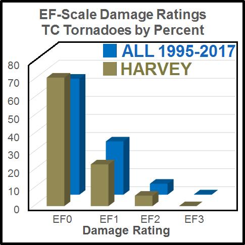
8 TC TORNADO FACTS & CLIMATOLOGY DAMAGE RATINGS PERCENT by EF RATING

9 TC TORNADO FACTS & CLIMATOLOGY DAYTIME FAVORED In deep moist environment, even subtle warming under cloud cover or in clear slots greatly increases instability. Harvey s 52 total tornadoes skewed toward morning


10 TC TORNADO FACTS & CLIMATOLOGY ALL TCs H Tornadoes more common in SE sectors as TCs weaken WHY? TS TD and Unc. That sector s over water in most mature hurricanes!
11 TC TORNADO FORECASTING CONCEPTS INGREDIENTS-BASED THINKING VALID WHETHER MIDLATITUDE OR TROPICAL! MOISTURE: usually no problem!!! INSTABILITY: daytime heating offsets weak instability aloft LIFT: Spiral bands, embedded boundaries, FREQUENT ANALYSIS is CRUCIAL! VERTICAL SHEAR: Max in favored N NE - SSE sector Edwards 2012

12 SPC FORECASTS for HARVEY Day-4 8 Outlooks

13 SPC FORECASTS for HARVEY Day-3 Outlooks
14 SPC FORECASTS for HARVEY Day-2 Outlooks
15 SPC FORECASTS for HARVEY Day-1 Outlooks


16 SPC FORECASTS for HARVEY CITY of HOUSTON: 60 HOURS in TORNADO WATCHES WFO WARNING AREA: 96 HOURS!

17 PRELIMINARY TORNADO MAP: HARVEY (25 31 AUGUST 2017)

18 HARVEY vs. ALL-TIME LEADERS TROPICAL CYCLONE YEAR TORNADO REPORTS ALL- TIME TOP-10 LIST H Ivan H Beulah H Frances H Rita H Katrina H Andrew TS Fay H Gustav H Cindy H Georges From TCTOR and pre-1995 formal studies H Harvey


19 Hurricane Harvey: The greatest rainfall from a U.S. Tropical Cyclone Allison 2001


 -23 of these")
20 Tornadoes were a legitimate threat, too 96 hours continuous under a tornado watch - 4 full days 60 hours for Houston 157 tornado warnings Fri. morning - Mon. evening 24* confirmed tornadoes near Houston (*few surveys ) -23 of these Friday aftn-saturday night


21 Environment east/northeast of center Late afternoon/evening Aug. 25 SIGNIFICANT TORNADO PARAMETER RADAR COMPOSITE INFRARED SATELLITE


22 Environment east/northeast of center Late afternoon/evening Aug. 26 SIGNIFICANT TORNADO PARAMETER RADAR COMPOSITE INFRARED SATELLITE


23 Environment east/northeast of center Late afternoon/evening Aug. 27 SIGNIFICANT TORNADO PARAMETER RADAR COMPOSITE INFRARED SATELLITE

24 Harvey was a messaging nightmare! How do you process all this?! Record rainfall forecast Historic flooding Flooding- flash and then river Reservoirs and levee issues So many overlapping hazards!! 6 days of Tropical Storm and/or Storm Surge watches and warnings 4 consecutive days under a tornado watch A named storm helped!


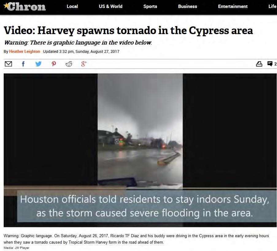
25 Harvey: The Epitome of Overlapping Tornado and Flash Flood Warnings/Threats Tornado Warning calls to action and Civil Emergency messaging were sending conflicting messages: Seek shelter now Get on your roof

26 Life-saving Messaging Tweet Impressions: r 1,831,082 As water rises in the home, an electrocution threat can develop. Didn t want people to become trapped in their attics. Also can not see that they need to be rescued if in the attic.

27 Harvey Alert Fatigue and Mixed Messages Because of repeated tornado/flash flood warnings some likely turned off their phone emergency alerts. We want to make sure our most critical warnings/alerts are received, and people take appropriate actions. The Tornado Alert is Extreme and the Flash Flood Warning is Severe.

28 Tornadoes and Flash Flooding: Not a new problem Nielson et al., WAF overlapping warnings/year occurred on average between verified TORFF events between results indicate that TORFF events occur with appreciable frequency and in complex meteorological scenarios....present difficult challenges both from the perspective of forecasting and public communication. Life-saving actions for each hazard are contradictory! Fig. 1 from Nielsen et al, WAF 2015

29 Oklahoma City: May 31, 2013 Tornadoes and Flooding Recommendation: The NWS needs to develop warning protocol when there are multiple severe weather elements in the warning so that each element of the warning is weighted based on its urgency and severity. This protocol should include wording on how the public should prepare and respond to multiple, simultaneous dangers such as tornadoes and flooding.
30 Overarching Challenges NWS short fuse warning program is designed for individual threats Prioritizing and effectively messaging multiple and dynamic threats (can change during an event) Must not forget Human Element in catastrophic events Fear, anxiety, excitement, etc We tend to warn more, when perhaps we need to scale back to focus on the more serious threat(s)?

31 Harvey Example: Tornado > Flooding PRECAUTIONARY/PREPAREDNESS ACTIONS... Tornado Warning Heavy rainfall may hide this tornado. Do not wait to see or hear the tornado. TAKE COVER NOW! Tornadoes are extremely difficult to see and confirm at night. Do not wait to see or hear the tornado. TAKE COVER NOW! Friday Night (1249 AM 8/26/17) Landfall occurring

32 Harvey Example: Tornado > Flooding * At 1231 AM CDT, local law enforcement officials reported heavy rain across the warned area. Water is covering FM 655 and CR 521 near Rosharon. Flash Flood Warning Flash flooding is expected to begin shortly. Friday Night (1233 AM 8/26/17)

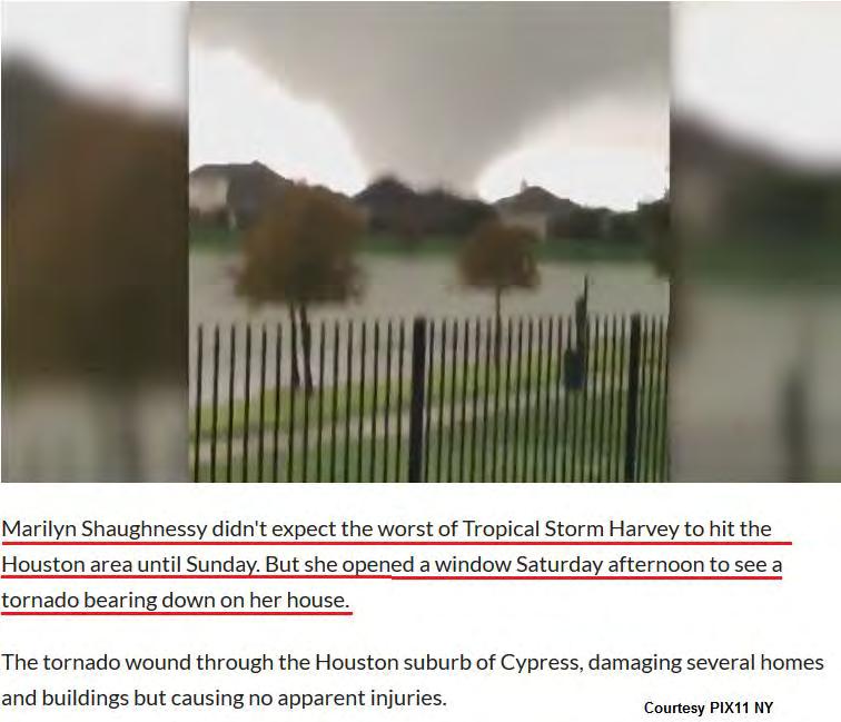
33 High-end EF1 Tornado Damage A tornado swept through Sienna Plantation in Missouri City, damaging at least 50 houses. Houston Press.

34 Example: FF Emergency > Tornadoes torrential rainfall rates of 4 to 6 inches per hour. Some of these areas have had already had 6 to 15 Flash Flood Emergency inches Flash flooding is ongoing and many rivers and bayous in the area are out of banks. This is a FLASH FLOOD EMERGENCY for portions of Galveston, Brazoria and Harris county. This is a PARTICULARLY DANGEROUS SITUATION. PRECAUTIONARY/PREPAREDNESS ACTIONS... Move to higher ground now. This is an extremely dangerous and life-threatening situation. Do not attempt to travel unless you are fleeing an area subject to flooding or under an evacuation order. Saturday Night (1130 PM 8/26/17)

35 Example: FF Emergency > Tornadoes IMPACT...Flying debris will be dangerous to those caught without shelter. Mobile homes will be damaged or destroyed. Damage to roofs, windows, and vehicles will occur. Tree damage is likely. Tornado Warning PRECAUTIONARY/PREPAREDNESS ACTIONS... TAKE COVER NOW! Move an interior room on the lowest floor of a sturdy building. Avoid windows. If you are outdoors, in a mobile home, or in a vehicle, move to the closest substantial shelter and protect yourself from flying debris. Saturday Night (1130 PM 8/26/17)


36 Historic flooding Dickinson, TX Aug 27th I-45 Sunday morning, Aug 27th A gasoline pump awning at the Dude Stop convenience store in Webster, Texas, is partially collapsed on Sunday, Aug. 27, after remnants of Hurricane Harvey inundated the area.(photo: Stuart Villanueva/The Galveston County Daily News via AP) Kelsey Walling/The Daily News Kelsey Walling/The Daily News Bay Area Houston Magazine

 Bay Area")
37 EF0 Tornado Damage at The Dude Stop A gasoline pump awning at the Dude Stop convenience store in Webster, Texas, is partially collapsed on Sunday, Aug. 27, after remnants of Hurricane Harvey inundated the area.(photo: Stuart Villanueva/The Galveston County Daily News via AP) Bay Area Houston Magazine
38 We Can Improve Need to be able to quickly adjust our calls to action and remove those that contradict a more severe hazard. I.E. in a tornado warning during a Flash Flood Emergency, actually state that the most dangerous threat is flooding. The other warning could be considered an awareness of a lesser threat, or not issued at all - if expecting a weak tornado or marginal flash flood threat. Concerning the Wireless Emergency Alerts (WEA) and the tornado warning call to action Take shelter now : we need to be able to change it when necessary. We could develop a trigger in the warning that would make this call to action selectable. For example: Avoid flood waters, take shelter if possible
39 A Suggested Call to Action TAKE COVER NOW! Move to an interior room on the lowest floor of a sturdy building. Avoid windows. If you are outdoors, in a mobile home, or in a vehicle, move to the closest substantial shelter and protect yourself from flying debris. Call to action changed to The main threat remains life threatening flooding. If your home is flooded, avoid flood waters. If possible, take shelter in an interior room. Avoid windows.

40 David J. Phillip / AP Thanks for your Attention!
 NWS Houston: www.weather.gov/hgx Contact: Jeffry.Evans@noaa.")
41 Storm Prediction Center: Contact: (former NHC meteorologist) NWS Houston: Contact: (former SPC meteorologist)
TROPICAL CYCLONE TORNADOES
 TROPICAL CYCLONE TORNADOES 2018 GOVERNOR S HURRICANE CONFERENCE TUESDAY, MAY 15, 2018 WILL ULRICH NWS FORECAST OFFICE MELBOURNE WHERE ARE THE TORNADOES? WHERE ARE THE TORNADOES? C B A WEST MELBOURNE, FL
Frank Revitte National Weather Service. Weather Forecast Office New Orleans/Baton Rouge
 Frank Revitte National Weather Service Weather Forecast Office New Orleans/Baton Rouge Above normal activity 17 Total Named Storms 7 Tropical Storms 4 Hurricanes 6 Major Hurricanes Not the most active,
National Weather Service
 National Weather Service Integrated Warning Team Workshops: NWS Warnings and Outdoor Warning Sirens Tim Halbach Warning Coordination Meteorologist Milwaukee NWS Integrated Warning Team NWS State Officials
Hurricane Harvey: SE Texas Impacts. 10 AM CDT UPDATE Saturday, August 26, 2017 Prepared by: Dan Reilly, Brian Kyle
 Hurricane Harvey: SE Texas Impacts 10 AM CDT UPDATE Saturday, August 26, 2017 Prepared by: Dan Reilly, Brian Kyle Latest Observations and Radar Hurricane Harvey centered near Victoria and weakening Wind
Hurricane Harvey: SE Texas Impacts. 10 PM CDT UPDATE Friday, August 25, 2017 Prepared by: Lance Wood
 Hurricane Harvey: SE Texas Impacts 10 PM CDT UPDATE Friday, August 25, 2017 Prepared by: Lance Wood Latest Observations Hurricane Harvey making landfall this evening near Rockport as a category 4 hurricane.
Tropical Storm Harvey: SE Texas Impacts. 10 AM CDT UPDATE Sunday August 27, 2017 Prepared by: Lance Wood
 Tropical Storm Harvey: SE Texas Impacts 10 AM CDT UPDATE Sunday August 27, 2017 Prepared by: Lance Wood Situation Overview Catastrophic flooding is ongoing with flash flood emergencies remaining in effect.
Tropical Storm Harvey: SE Texas Impacts
 Tropical Storm Harvey: SE Texas Impacts 10 AM CDT UPDATE Thursday, August 24, 2017 Prepared by: Dan Reilly, Brian Kyle PLEASE MUTE YOUR LINES AND DON T PUT ON HOLD! Situation Overview Tropical Storm Harvey
GC Briefing. Weather Sentinel Tropical Storm Michael. Status at 8 AM EDT (12 UTC) Today (NHC) Discussion. October 11, 2018
 Today (NHC) Discussion. October 11, 2018") GC Briefing Weather Sentinel Tropical Storm Michael October 11, 2018 After making landfall as a high-end category-4 hurricane on the Florida Panhandle, Michael weakened to tropical storm status early this
GC Briefing Weather Sentinel Tropical Storm Michael October 11, 2018 After making landfall as a high-end category-4 hurricane on the Florida Panhandle, Michael weakened to tropical storm status early this
NWS HURRICANES June 3, 2015
 NWS HURRICANES June 3, 2015 Hurricane Season June 1 November 30 2 What s the concern? All tropical systems passing within 125nm of central Maryland since 1950 Mid-Atlantic Hurricanes Greatest Risk: August
Significant Flooding Expected
 Significant Flooding Expected Decision Support Briefing #5 As of: 9:00 AM September 14, 2018 What Has Changed? Flash Flood Watch now in effect for part of area, will be expanded later today 9/14/2018 9:23
Name Earth Science Pd. Hurricanes. Directions: Read the information, view diagrams and answer the questions in the worksheet.
 Hurricanes Directions: Read the information, view diagrams and answer the questions in the worksheet. Hurricane Basics The ingredients for a hurricane include a pre-existing weather disturbance, warm tropical
Are You Ready For Hurricane Season? 2018 Hurricane Talk B Y : S T O R M T E A M 8 M E T E O R O L O G I S T J U L I E P H I L L I P S
 Are You Ready For Hurricane Season? 2018 Hurricane Talk B Y : S T O R M T E A M 8 M E T E O R O L O G I S T J U L I E P H I L L I P S About Me I am Currently a Weekday Meteorologist at WFLA Channel 8.
Hurricane Matthew Threats and Impacts Briefing for Eastern NC
 Hurricane Matthew Threats and Impacts Briefing for Eastern NC October 6 th, 2016 Date/Time Created: 10/6/2016, Noon EDT National Weather Service Newport/Morehead City, NC Hurricane Matthew Key Points Changes
MET Lecture 29 Tornadoes IV
 MET 4300 Lecture 29 Tornadoes IV Outline Definition, life cycle, & climatology of tornadoes Tornado formation within supercells Tornado formation within nonsupercell thunderstorms Fujita scale Tornado
2013 Tornado and Severe Weather Awareness Drill
 2013 Tornado and Severe Weather Awareness Drill Scheduled for Thursday April 18, 2013 The 2013 Tornado Drill will consist of a mock tornado watch and a mock tornado warning for all of Wisconsin. This is
Major Hurricane Matthew Briefing Situation Overview
 Major Hurricane Matthew Briefing Situation Overview THIS IS NOW A WORST CASE STORM SURGE SCENARIO Catastrophic Damage is Anticipated for Coastal Areas. Major Hurricane Matthew is still expected to move
Hurricane Harvey and What is to come. Eric Berger, Space City Weather
 Hurricane Harvey and What is to come Eric Berger, Space City Weather Today s talk A word about Space City Weather Social media-rology A look back at Hurricane Harvey Why does Houston get these storms Rainfall
Tornadoes. A. T. Willett/The Image Bank/Getty Images
 Tornadoes A. T. Willett/The Image Bank/Getty Images Created by Chelsea Austin Introduction to Physical Science, EMPACTS Project, Fall 2012 How are Tornadoes related to Hurricanes? Tornadoes are spawned
Hurricane Matthew. Life Threatening Flash Flooding Likely. National Weather Service Wilmington NC. Josh Weiss, Meteorologist
 Hurricane Matthew Life Threatening Flash Flooding Likely Threat Assessment for northeast South Carolina & southeast North Carolina National Weather Service Wilmington NC 630 PM EDT Friday October 7, 2016
IN VEHICLES: Do not try to outrun a tornado. Abandon your vehicle and hide in a nearby ditch or depression and cover your head.
 TORNADO SAFETY TORNADO! The very word strikes fear in many people. While a tornado is perhaps nature's most destructive storm, deaths and injuries can be prevented. By following Tornado Safety Rules, lives
Severe Weather Hazards Are Real
 Severe Weather Hazards Are Real In the past 10 years, more than 40 people have died and dozens more injured as a result of weatherrelated events in Minnesota (not including motor vehicles.) The top severe
Your Task: Read each slide then use the underlined red or underlined information to fill in your organizer.
 Severe Weather: Tornadoes and Hurricanes Thunderstorms and Lightning S6E4 d. Construct an explanation of the relationship between air pressure, weather fronts, and air masses and meteorological events
TROPICAL STORM NATE BRIEFING
 TROPICAL STORM NATE BRIEFING 5:00 AM CDT Friday, October 6, 2017 Prepared by: NWS NWSNewOrleans www.weather.gov/neworleans Situation Overview No significant changes to the track forecast this morning.
Hurricane Matthew Life Threatening Flash Flooding Likely
 Hurricane Matthew Life Threatening Flash Flooding Likely Threat Assessment for northeast South Carolina & southeast North Carolina National Weather Service Wilmington NC 12 AM EDT Saturday October 8, 2016
HURRICANES. Source:
 HURRICANES Source: http://www.dc.peachnet.edu/~pgore/students/w97/matheson/hpage.htm What is a hurricane? Violent cyclonic storm that develops in the tropical region Wind speeds are > 74 mph Source: http://www.google.com/imgres?hl=en&sa=x&biw=1920&bih=955&tbm=
The Wind Hazard: Messaging the Wind Threat & Corresponding Potential Impacts
 The Wind Hazard: Messaging the Wind Threat & Corresponding Potential Impacts Scott Spratt Warning Coordination Meteorologist NWS Melbourne, FL David Sharp Science & Operations Officer NWS Melbourne, FL
TROPICAL STORM HARVEY BRIEFING
 TROPICAL STORM HARVEY BRIEFING 10:00 AM CDT Sunday, August 27, 2017 Prepared by: NWS LIX NWSNewOrleans www.weather.gov/neworleans Situation Overview New Information Tropical Storm Winds 40mph Immediate
Severe Weather Potential for Southeast Texas
 Severe Weather Potential for Southeast Texas Dan Reilly, Kent Prochazka, Scott Overpeck National Weather Service Houston/Galveston 10 am Synopsis Storm to likely bring severe weather to Southeast Texas
Advisory #35 Briefing 630 PM EDT Thursday October 06, 2016
 Advisory #35 Briefing 630 PM EDT Thursday October 06, 2016 Disclaimer: The information contained within this briefing is time-sensitive, do not use beyond 6 hours after the issuance Next Webinar Update:
Tornadoes. tornado: a violently rotating column of air
 Tornadoes tornado: a violently rotating column of air Tornadoes What is the typical size of a tornado? What are typical wind speeds for a tornado? Five-stage life cycle of a tornado Dust Swirl Stage Tornado
Tropical Cyclone Hazards. Presentation
 Tropical Cyclone Hazards Presentation Kerry N Mallory AE5JY September 7, 2011 Tropical Cyclone Hazards The Four Primary Weapons of a Tropical Cyclone are: 1. Wind 2. Storm Surge 3. Rain/Freshwater Flooding
TROPICAL STORM HARVEY BRIEFING
 TROPICAL STORM HARVEY BRIEFING 8:00 AM CDT Monday, August 28, 2017 Prepared by: Brian Hoeth, Jason Johnson, on behalf of WGRFC www.weather.gov Current Storm Total Rainfall and River Flood Status 24 Storm
2008 Hurricane Caravan. Daniel Noah Meteorologist National Weather Service x1 May 22, 2008
 2008 Hurricane Caravan Daniel Noah Meteorologist National Weather Service daniel.noah@noaa.gov, 813-645-2323 x1 May 22, 2008 National Weather Service We never close! Open 24 hours a day 365 days per year
United States Multi-Hazard Early Warning System
 United States Multi-Hazard Early Warning System Saving Lives Through Partnership Lynn Maximuk National Weather Service Director, Central Region Kansas City, Missouri America s s Weather Enterprise: Protecting
State Of Wisconsin Department of Military Affairs
 State Of Wisconsin Department of Military Affairs Division of Emergency Management Brian M. Satula Administrator Scott Walker Governor For more information contact: Tod Pritchard Office: 608-242-3324 Cell:
Severe Weather: Tornadoes and Hurricanes
 Severe Weather: Tornadoes and Hurricanes Tornadoes Grab Toto!! TORNADOES Are a low pressure storm that usually forms over land in an average year, 800 tornadoes are reported in the U.S. a tornado is defined
2017 Hurricane Season and Beyond
 2017 Hurricane Season and Beyond Ken Graham National Hurricane Center Building a Weather-Ready Nation Much of U.S. Coast Saw Tropical Wind Watches or Warnings 2017 Hurricane Season Facts and Figures 7th
Severe Weather Watches, Advisories & Warnings
 Severe Weather Watches, Advisories & Warnings Tornado Watch Issued by the Storm Prediction Center when conditions are favorable for the development of severe thunderstorms and tornadoes over a larger-scale
LECTURE #15: Thunderstorms & Lightning Hazards
 GEOL 0820 Ramsey Natural Disasters Spring, 2018 LECTURE #15: Thunderstorms & Lightning Hazards Date: 1 March 2018 (lecturer: Dr. Shawn Wright) I. Severe Weather Hazards focus for next few weeks o somewhat
COMMUNITY EMERGENCY RESPONSE TEAM TORNADOES
 Tornadoes are powerful, circular windstorms that may be accompanied by winds in excess of 200 miles per hour. Tornadoes typically develop during severe thunderstorms and may range in width from several
Tropical Update. 5 PM EDT Sunday, September 10, 2017 Hurricane Irma, Hurricane Jose, Tropical Wave (60%)
") Tropical Update 5 PM EDT Sunday, September 10, 2017 Hurricane Irma, Hurricane Jose, Tropical Wave (60%) This update is intended for government and emergency response officials, and is provided for informational
Tropical Update 5 PM EDT Sunday, September 10, 2017 Hurricane Irma, Hurricane Jose, Tropical Wave (60%) This update is intended for government and emergency response officials, and is provided for informational
Tornadoes pose a high risk because the low atmospheric pressure, combined with high wind velocity, can:
 Tornadoes are powerful, circular windstorms that may be accompanied by winds in excess of 200 miles per hour. Tornadoes typically develop during severe thunderstorms and may range in width from several
HURRICANES AND TORNADOES
 HURRICANES AND TORNADOES The most severe weather systems are hurricanes and tornadoes. They occur in extremely low pressure systems, or cyclones, when the air spirals rapidly into the center of a low.
Mark Fox Meteorologist NWS Fort Worth, TX
 Mark Fox Meteorologist NWS Fort Worth, TX Mark Fox Meteorologist NWS Fort Worth, TX What does severe really mean? Heavy Rain? Hail? Flooding? Wind? Lightning? What does severe really mean? Photo: Mike
TROPICAL DEPRESSION HARVEY BRIEFING
 TROPICAL DEPRESSION HARVEY BRIEFING 10:15 PM CDT Wednesday, August 23, 2017 Prepared by: Lara Beal NWSCorpus www.weather.gov/corpuschristi Situation Overview No changes to Watches. Hurricane Watch remains
May 31, Flood Response Overview
 May 31, 2013 Flood Response Overview Suppression 867 Personnel on three (3) shifts 289 Red Shift (A) 289 Blue Shift (B) 289 Green Shift (C) Department Overview Department Overview EMS: 40,934 False Alarm:
We Had No Warning An Overview of Available Forecast Products Before and During Severe Weather Events
 We Had No Warning An Overview of Available Forecast Products Before and During Severe Weather Events Two main sources for severe weather info NOAA/NWS Storm Prediction Center (SPC) Convective Outlooks
4/18/2010. National Weather Service. Severe Weather Forecasting: A Western North Carolina Case Study
 National Weather Service Severe Weather Forecasting: A Western North Carolina Case Study Laurence G. Lee Science and Operations Officer National Weather Service Greer, SC Plus 13 River Forecast Centers
1st Tornado Photograph
 Lecture 26 Part II Tornados Environment Storm Structure Life Cycle Source of Spin Forecasting Climatology Damage Marilee Thomas of Beaver City, NE took this photograph of her daughter Audra about two miles
2015 Hurricane Season BY: STORM TEAM 8 METEOROLOGIST JULIE PHILLIPS
 2015 Hurricane Season BY: STORM TEAM 8 METEOROLOGIST JULIE PHILLIPS FORECAST COLORADO STATE UNIVERSITY FORECAST IS CALLING FOR ONE OF THE LEAST ACTIVE SEASONS SINCE THE MID 20 TH CENTURY! THE OFFICIAL
Tornadoes. Tornadoes COMMUNITY EMERGENCY RESPONSE TEAM TORNADOES
 Tornadoes Tornadoes Tell the participants that tornadoes are powerful, circular windstorms that may be accompanied by winds in excess of 200 miles per hour. Tornadoes typically develop during severe thunderstorms
Mature Tornado. Tornado funnel and debris cloud. Mature Tornado
 Mature Tornado Tornado funnel and debris cloud 43 Mature Tornado 44 Tornado in Final Rope Stage 45 Source of Spin 46 Source of Spin Updraft Stretches Rotating Column 47 Simulation of Tornado Formation
Tornadoes. Be able to define what a tornado is. Be able to list several facts about tornadoes.
 Tornadoes Be able to define what a tornado is. Be able to list several facts about tornadoes. 1. Where do tornadoes most U.S. is # 1 occur in the world? Tornadoes are most common in Tornado Alley. Tornado
TORNADOES. DISPLAY VISUAL A Tornado Is... Tornadoes can: Rip trees apart. Destroy buildings. Uproot structures and objects.
 TORNADOES Introduce tornadoes by explaining what a tornado is. DISPLAY VISUAL A Tornado Is... A powerful, circular windstorm that may be accompanied by winds in excess of 250 miles per hour. Tell the participants
TROPICAL STORM HARVEY BRIEFING
 TROPICAL STORM HARVEY BRIEFING 1 PM CDT Saturday, August 26, 2017 Prepared by: John Metz NWSCorpus www.weather.gov/corpuschristi Overview Life-threatening conditions continue. Storm Surge Warnings remain
Hydrologic Briefing Tropical Storm Harvey
 Hydrologic Briefing Tropical Storm Harvey 10:30 AM CDT Sunday, August 27, 2017 Prepared by: John Metz NWSCorpus www.weather.gov/corpuschristi Situation Overview Tropical Storm Harvey Harvey to remain a
State Of Wisconsin. Department of Military Affairs. Division of Emergency Management
 State Of Wisconsin Department of Military Affairs Division of Emergency Management Brian M. Satula Administrator Scott Walker Governor For more information contact: Tod Pritchard Office: 608-242-3324 Cell:
2A.5 A Climatology of Catastrophic Flooding in Texas From Tropical Cyclones Derek Ortt and Cameron Self StormGeo Inc, Houston, Texas
 2A.5 A Climatology of Catastrophic Flooding in Texas From Tropical Cyclones Derek Ortt and Cameron Self StormGeo Inc, Houston, Texas 1. INTRODUCTION In August 2017, Hurricane Harvey produced catastrophic
THE IMPACT OF WEATHER
 The United States is the most severe weather prone country in the world. Each year, people in this country cope with an average of 10,000 thunderstorms, 5,000 floods, 1,200 tornadoes and two landfalling
A guide to thunderstorms and how to stay safe when they strike!
 A guide to thunderstorms and how to stay safe when they strike! Thunderstorms, are a violent example of convection. At any given moment, there are an estimated 1,500 thunderstorms in progress somewhere
NOAA s National Weather Service Philadelphia/Mt. Holly NJ
 Next Briefing Package: Friday, October 2, 2015 no later than 300 PM Hazards and Impacts: Overview: A dangerous weather pattern still threatens our region. Threats include very heavy rainfall, inland river
Hurricane Irma. City of Cocoa Beach September 8 12, 2017
 Hurricane Irma City of Cocoa Beach September 8 12, 2017 Monitoring prior to landfall Expected effects What happened What went well What didn t go well Changes and improvements After Action Outline Storm
Thunderstorms. Thunderstorm Recipe
 Thunderstorms A thunderstorm is a storm with lightning and thunder. It's produced by a cumulonimbus cloud, usually producing gusty winds, heavy rain and sometimes hail. A typical thunderstorm is 15 miles
National Weather Service
 National Weather Service Performance and Challenges Warning Systems Kenneth E. Graham Meteorologist-in-Charge New Orleans Busy 2008 Number of Tornadoes Number of Tornado Fatalities *Preliminary So Far
GC Briefing. Weather Sentinel Hurricane Florence. Status at 5 PM EDT (21 UTC) Today (NHC) Discussion. September 13, 2018
 Today (NHC) Discussion. September 13, 2018") GC Briefing September 13, 2018 Weather Sentinel Hurricane Florence Tropical storm conditions have been reported for areas of North Carolina and will continue to spread inland to the west and south. Hurricane
GC Briefing September 13, 2018 Weather Sentinel Hurricane Florence Tropical storm conditions have been reported for areas of North Carolina and will continue to spread inland to the west and south. Hurricane
Continuity in the Face of Hurricanes: What Every Business Needs To Know. Cameron Self, Tropical Meteorologist. StormGeo
 Continuity in the Face of Hurricanes: What Every Business Needs To Know Cameron Self, Tropical Meteorologist. StormGeo A Hurricane is a Big Heat Engine Forming over warm tropical waters, wind speeds range
ERTH 365 Homework #2: Hurricane Harvey. 100 points
 ERTH 365 Homework #2: Hurricane Harvey 100 points Due by 6pm, Tuesday 30 October 2018, ELECTRONIC SUBMISSON BY EMAIL ONLY BY 6PM (send to klevey@sfsu.edu) (acceptable formats: MS Word, Google Doc, plain
A LOOK AT TROPICAL STORM GASTON FLOODING IN VIRGINIA
 J12B.4 A LOOK AT TROPICAL STORM GASTON FLOODING IN VIRGINIA John Billet* and Keith Lynch NOAA/NWS Wakefield, VA 1. INTRODUCTION Hurricane Gaston made landfall north of Charleston, SC on Sunday morning
Safety Issue: Types of weather emergencies and natural. Weather Emergencies
 Overview Safety Issue: Rapid and effective response to weather emergencies and other natural disasters whether during or after work hours takes forethought and careful planning. Types of weather emergencies
Tropical Storm Ana. Created 6:00 AM Sun May 10, 2015 John Cole Warning Coordination Meteorologist
 Tropical Storm Ana Threat Assessment for Eastern North Carolina Created 6:00 AM Sun May 10, 2015 John Cole Warning Coordination Meteorologist John.cole@noaa.gov National Weather Service Newport/Morehead
Hurricane Recipe. Hurricanes
 Hurricanes A hurricane is a powerful, rotating storm that forms over warm oceans near the Equator. Hurricanes have strong, rotating winds (at least 74 miles per hour), a huge amount of rain, low air pressure,
High Resolution Numerical Weather Prediction for High Impact and Extreme Weather Events in 2014 across Southern California
 High Resolution Numerical Weather Prediction for High Impact and Extreme Weather Events in 2014 across Southern California Alex Tardy Alexander.Tardy@noaa.gov NWS San Diego Warning Coordination Meteorologist
Module 11: Meteorology Topic 6 Content: Severe Weather Notes
 Severe weather can pose a risk to you and your property. Meteorologists monitor extreme weather to inform the public about dangerous atmospheric conditions. Thunderstorms, hurricanes, and tornadoes are
Major Hurricane Earl
 Major Hurricane Earl Advisory 32 North Carolina Threat Assessment Prepared at: 8 AM Thursday September 2, 2010 Hurricane and Tropical Storm Warnings in effect for the North Carolina Coast and Sounds. NWS
HURRICANE HARVEY COE Navigation BRIEFING
 HURRICANE HARVEY COE Navigation BRIEFING 10:00 AM CDT Friday, August 25, 2017 NWSNewOrleans www.weather.gov/neworleans Situation Overview New Information Harvey continues to strengthen Max sustained winds
TROPICAL STORM NATE BRIEFING
 TROPICAL STORM NATE BRIEFING 10:30 AM CDT Friday, October 06, 2017 Prepared by: NWS NWSNewOrleans www.weather.gov/neworleans Situation Overview Track forecast has shifted slightly eastward. Hurricane Watch
Ben Hogben. RRLC October 12, 2016
 Ben Hogben RRLC October 12, 2016 What is your procedure for handling books that are returned damaged? 1. Meet with other staff who may be involved with the process 2. Talk about processes 3. Develop a
Lightning Realizing the Danger. ABOVE ALL Lightning is UNPREDICTABLE!!! Can Strike 15+ Miles Away from Thunderstorm
 Lightning Safety Lightning Realizing the Danger ABOVE ALL Lightning is UNPREDICTABLE!!! Can Strike 15+ Miles Away from Thunderstorm X Lightning Realizing the Danger Lightning Deaths So Far This Year Lightning
Charles Kuster Leadville, CO. Personal Overview
 Charles Kuster Leadville, CO Personal Overview Personal Overview Charles Kuster Leadville, CO OU to study meteorology Charles Kuster Leadville, CO Personal Overview OU to study meteorology Graduated in
Severe Weather. Copyright 2006 InstructorWeb
 Severe Weather People need to know what the weather is going to do. Sometimes severe weather can happen. Severe weather can cause property damage, injuries to people and animals, and even loss of life.
National Hurricane Program. FEMA Region IV
 National Hurricane Program FEMA Region IV Percent NHP A quick background Hurricane Program major buckets (Toolboxes) Hurricane Evacuation Study HURREVAC Post Storm Assessments Training Hurricane Liaison
Lessons Learned from Hurricane Harvey and Irma
 EOL Visit to NSF 3 March 2016 Lessons Learned from Hurricane Harvey and Irma Wen-Chau Lee National Center for Atmospheric Research 23 November 2017 Outline: Meteorological elements of the active 2017 Atlantic
SPC Mission Statement. Tornado in Miami, FL Photo: Miami Herald. What is SPC s Responsibility? More SPC Products. SPC Products
 The NOAA/NWS Storm Prediction Center Adapted from a presentation to UNCA atmospheric science students by David Imy SPC Mission Statement SPC exists to protect life and property of the American people through
Hurricane Harvey Flood Emergency Response
 Hot Science - Cool Talk # 114 Hurricane Harvey Flood Emergency Response Dr. David Maidment September 14, 2018 Produced by and for Hot Science - Cool Talks by the Environmental Science Institute. We request
A HURRICANE IS COMING. Presented by Atiba Upchurch Broward Emergency Management Division
 A HURRICANE IS COMING Presented by Atiba Upchurch Broward Emergency Management Division Mission Statement To safeguard the lives and property of the people of Broward County from major hazards and emergencies
Storm Surge Forecast with Shifting Forecast Tracks
 Storm Surge Forecast with Shifting Forecast Tracks Storm Surge Findings in the Florida Keys Jon Rizzo Warning Coordination Meteorologist National Weather Service Florida Keys Florida Keys Life History
10 years after Hurricane Charley
 10 years after Hurricane Charley Hurricane Charley (2004) A Retrospective Scott M. Spratt Warning Coordination Meteorologist NWS Melbourne, FL Florida Governors Hurricane Conference May 15, 2014 11 AM
Impact Based Warning Tornado - Infrastructure
 National Weather Service Impact Based Warning Tornado - Infrastructure Jim Kramper Warning Coordination Meteorologist St. Louis, MO NOAA s National Weather Service 2011 was a devastating year for tornado
Hurricanes. Environmental Geology Mr. Paul Lowrey. Stacey Singleton, Cassandra Combs, Dwight Stephenson, Matt Smithyman
 Environmental Geology Mr. Paul Lowrey Stacey Singleton, Cassandra Combs, Dwight Stephenson, Matt Smithyman Hurricanes EMPACTS Project, Spring 2017 Northwest Arkansas Community College, Bentonville, AR
Tropical Update. 11 AM EDT Wednesday, October 10, 2018 Hurricane Michael, Hurricane Leslie & Tropical Storm Nadine, Caribbean Low (40%)
") Tropical Update 11 AM EDT Wednesday, October 10, 2018 Hurricane Michael, Hurricane Leslie & Tropical Storm Nadine, Caribbean Low (40%) This update is intended for government and emergency response officials,
Tropical Update 11 AM EDT Wednesday, October 10, 2018 Hurricane Michael, Hurricane Leslie & Tropical Storm Nadine, Caribbean Low (40%) This update is intended for government and emergency response officials,
Daily Operations Briefing. Wednesday, August 23, :30 a.m. EDT
 Daily Operations Briefing Wednesday, August 23, 2017 8:30 a.m. EDT Significant Activity August 22-23 Significant Events: Tropical Weather Threat Gulf Coast Tropical Activity: Atlantic Disturbance 1 High
1C.4 TROPICAL CYCLONE TORNADOES: SYNOPTIC SCALE INFLUENCES AND FORECASTING APPLICATIONS
 1C.4 TROPICAL CYCLONE TORNADOES: SYNOPTIC SCALE INFLUENCES AND FORECASTING APPLICATIONS Daniel J. Cecil and Lori A. Schultz University of Alabama in Huntsville, Huntsville, AL, 35805 1. INTRODUCTION Several
TROPICAL STORM NATE BRIEFING
 TROPICAL STORM NATE BRIEFING 2:00 PM CDT Friday, October 06, 2017 Prepared by: NWS NWSNewOrleans www.weather.gov/neworleans Situation Overview Track forecast has not changed since the 10 am advisory. Hurricane
Hurricane Charley: A Retrospective 2014 Florida Governor s Hurricane Conference
 Hurricane Charley: A Retrospective 2014 Florida Governor s Hurricane Conference 2004 Hurricane Season: Storm Tracks Satellite Images of 2004 Hurricanes Charley Frances Ivan Jeanne Three Hurricanes in Polk
HURRICANE NATE BRIEFING
 HURRICANE NATE BRIEFING 2:00 PM CDT Saturday, October 07, 2017 Prepared by: NWS NWSNewOrleans www.weather.gov/neworleans Situation Overview continues to intensify. It is now forecast to be a category 2
Key Takeaways: - Rain: Coastal NC: ; isolated totals to 40 Central, Western, & Northeastern NC: 5-10 ; isolated totals to 20
 Key Takeaways: - Life-Threatening Impacts Will Extend Far From The Storm s Center: Despite the southward shift in track, widespread and extreme impacts from heavy rain, storm surge, and wind are still
WEATHER SYSTEMS IMPACTING THE CAYMAN ISLANDS Prepared by the staff of the Cayman Islands National Weather Service
 WEATHER SYSTEMS IMPACTING THE CAYMAN ISLANDS 2008 Prepared by the staff of the Cayman Islands National Weather Service TROPICAL STORM DOLLY Formed 194 miles west of Grand Cayman July 19 th. The tropical
The 2015 NWS Spring and Summer Weather Update
 http://weather.gov The 2015 NWS Spring and Summer Weather Update Western North Carolina severe weather climatology Tony Sturey, WCM Greenville/Spartanburg, SC North Carolina Spring and Summer Outlooks
California OES Weather Threat Briefing
 California OES Weather Threat Briefing Wednesday, January 16, 2019 9:00 AM PST Day 1: Strong winds, heavy mountain snow and heavy rain with isolated thunderstorms across much of the state through Thursday