LOG OF FEWS_TAIWAN IN MORAKOT -TOWARD RELIABLE PRIDICTION OF A EXTREME RAINFALL EVENT
|
|
|
- Candice Wilson
- 5 years ago
- Views:
Transcription
1 LOG OF FEWS_TAIWAN IN MORAKOT -TOWARD RELIABLE PRIDICTION OF A EXTREME RAINFALL EVENT Che-Hao Chang National Taipei University of Technology Department of Civil Engineering Taiwan
 Highest")
 Density 668 /km 2 (1,730")
2 GEOGRAPHICAL ENVIRONMENT AND WATER RESOURCES IN TAIWAN Area 35,980 km 2 (13,892 sq mi) Highest elevation 3,952 m (12,966 ft) Population 23,046,177 (as of 2009) Density 668 /km 2 (1,730 /sq mi) wiki


3 GEOGRAPHICAL ENVIRONMENT AND WATER RESOURCES IN TAIWAN Average annual rainfall 2489mm 2009 N 2937 M 2156 S 2518 E 2540 Total Rainfall 2502mm(1949~2008) 2489mm(2009)

4 From:


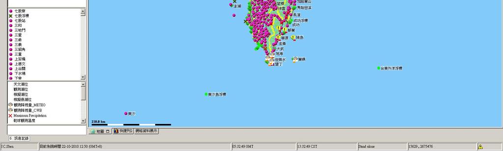
5 Water Resources Agency River water level station Central Weather Bureau Rainfall station Station: 156 Station: 471


6 Radar 10min 1.3 * 1.3km QPE unit : mm/hr 3 hour QPF unit : mm/hr


7 TYPHOON 2005~2010
8 MAJOR TYPHOON 2005~2010 AGRICULTURAL LOSSES 2010 MEGI 2,256, FANAPI 50,119, MORAKOT 388,921, JANGMI 7,529, SINLAKU 20,189, FUNG-WONG 4,182, KALMAEGI 13,728, KROSA 27,573, HAITANG 90,483,803 Order by losses Year Typhoon Billion(EUR) 2009 MORAKOT HAITANG FANAPI HERB KROSA MINDULLE SINLAKU TORAJI BILIS ZEB KALMAEGI NARI XANGSANE 1.127

9 MORAKOT CWB

10
11 RAINFALL STATISTICS Rainfall intensity with respect to durations 24hrs up to 1000mm 31 stations (max:1623.5mm) 48hrs up to 1500mm 23 stations (max:2361mm) 72hrs up to 2000mm 12 stations (max:2748mm)
12 8/5~8/10 Rainfall station Cumulative rainfall (mm) 1 Alishan Fencihu Weiliaoshan Shipanlong Yuyoushan Xinan Nantianchi Laitou Matoushan Shangdewen FROM: WRA

13 Rainfall station Cumulative rainfall (mm) Kaoping basin 1 Alishan Fencihu Weiliaoshan Shipanlong Yuyoushan Xinan Nantianchi Laitou Matoushan Shangdewen

14 TOP 10 STATIONS FOR 24 HOURS Basin Rainfall station Cumulative rainfall (mm) time 1 Choshui Alishan /8 14:00~8/9 14:00 2 Pachang Shipanlong /8 11:00~8/9 11:00 3 Pachang Fencihu /8 12:00~8/9 12:00 4 Kaoping Nantianchi /8 12:00~~8/9 12:00 5 Kaoping Weiliaoshan /7 23:00~8/8 23:00 6 Tsengwen Matoushan /8 07:00~8/9 07:00 7 Kaoping Xinan /8 05:00~8/9 05:00 8 Kaoping Yuyoushan /8 01:00~8/9 01:00 Kaoping basin 9 Kaoping Xiaoguansha /8 06:00~8/9 06:00 10 Kaoping Fuxing /8 12:00~8/9 12:00 31 stations

15 TOP 10 STATIONS FOR 48 HOURS Basin Rainfall station Cumulative rainfall (mm) time 1 Choshui Alishan /7 18:00~8/9 18:00 2 Kaoping Weiliaoshan /7 09:00~8/9 09:00 3 Pachang Fencihu /7 16:00~8/9 16:00 4 Pachang Shipanlong /7 14:00~8/9 14:00 5 Kaoping Nantianchi /8 06:00~8/10 06:00 6 Kaoping Xinan /7 18:00~8/9 18:00 7 Tsengwen Matoushan /7 08:00~8/9 08:00 8 Kaoping Yuyoushan /7 13:00~8/9 13:00 9 Kaoping Shangdewen /6 23:00~8/8 23:00 10 Kaoping Xiaoguansha /7 18:00~8/9 18:00 Kaoping basin 23 stations

16 TOP 10 STATIONS 72 HOURS Basin Rainfall station Cumulative rainfall (mm) time 1 Choshui Alishan /7 00:00~8/10 00:00 2 Pachang Fencihu /6 19:00~8/9 19:00 3 Kaoping Weiliaoshan /6 21:00~8/9 21:00 4 Pachang Shipanlong /6 16:00~8/9 16:00 5 Kaoping Yuyoushan /7 04:00~8/10 04:00 6 Kaoping Xinan /7 03:00~8/10 03:00 7 Kaoping Nantianchi /7 08:00~8/10 08:00 8 Tsengwen Matoushan /6 15:00~8/9 15:00 9 Pachang Dahu /6 19:00~8/9 19:00 Kaoping basin 10 Tsengwen Laitou /6 20:00~8/9 20:00 12 stations

17 TOP 10 CUMULATIVE RAINFALL Basin Rainfall station Cumulative rainfall (mm) Average annual rainfall (mm) % 1 Choshui Alishan Pachang Fencihu Kaoping Weiliaoshan Pachang Shipanlong Kaoping Yuyoushan Kaoping Xinan Kaoping Nantianchi Tsengwen Laitou Tsengwen Matoushan Kaoping Shangdewen Kaoping basin

18 RIVER WATER LEVEL STATIONS Over Warning Level 1 34 Station Over Warning Level 2 48 Station Warning level 1 Warning level 2 Warning level 3
19 DISASTER AND LOSS Flood area :765 KM 2 Bridge: 196 destroyed Kaohsiung 97 bridge were destroyed (49.5%) Dike :31 locations broken

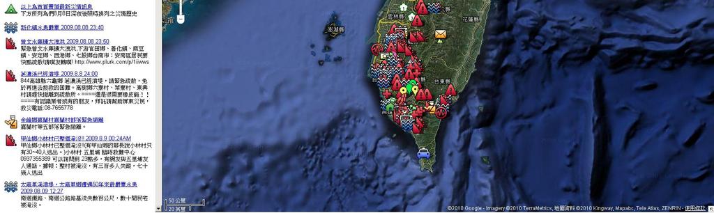
20 DISASTER INFORMATION THROUGH INTERNET


21 Photo From


22 Renwu, Kaohsiung Dashe,Kaohsiung Laiyi, Pingtung Taimali, Taitung Photo From WRA Linbian, Pingtung Linbian, Pingtung


23 DRIFTWOOD Pingtung Port of Taitung

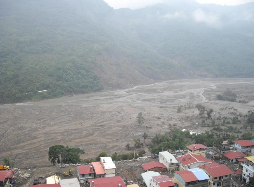
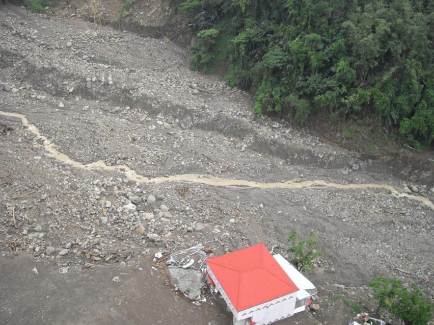
24 XIAOLIN VILLAGE LANDSLIDE (Kaoping Basin)


25 XIAOLIN VILLAGE LANDSLIDE Photo From:


26 Xiaolin village Water level station Kaoping basin Kaoping basin

27 XIAOLIN VILLAGE LANDSLIDE 1730H058 Basin 1730H046 Basin 1730H058 Sudden Jumping of Water Leverl Downstream 1730H046 Lost Signal Upstream
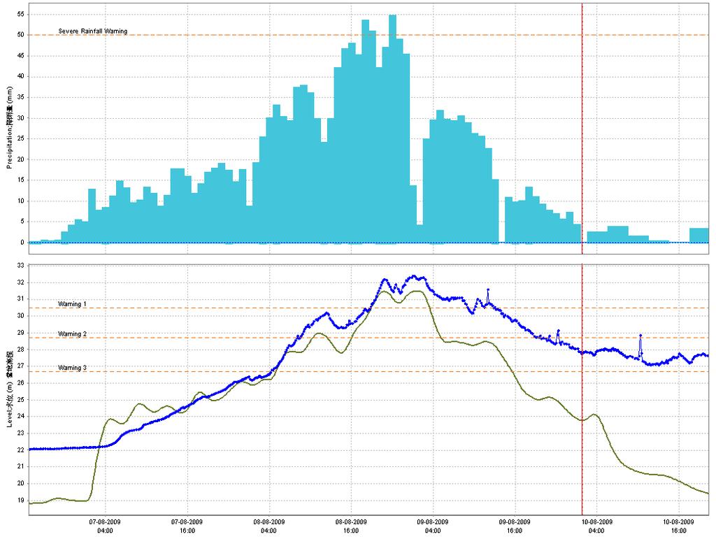
28 XIAOLIN VILLAGE LANDSLIDE 06:09 Landslide Dam 07:00 dam break H m


29 RAINFALL FORECAST IN DIFFERENT TIME Station: 1730H043 SAN-TI-MEN WRF CMT WRF GMT


30 EXTREME RAINFALL IN KAOHSIUNG TYPHOON FANAPI CWB NASA


31 TYPHOON FANAPI 17km Unit :mm/10min

32 EXTREME RAINFALL IN KAOHSIUNG TYPHOON FANAPI C1V410 5 hour : 539mm Max rainfall:124mm/hr C1V430 5 hour : 289.5mm Max rainfall:87mm/hr C1V440 5 hour : 280mm Max rainfall:78mm/hr C1V420 5 hour : 477mm Max rainfall :124.5mm/hr


33 Typhoon FANAPI in Kaohsiung City Photo from :National Airborne Service Corps


34 EXTREME RAINFALL NORTHEAST MONSOON WITH TYPHOON MEGI CWB NASA


35 EXTREME RAINFALL NORTHEAST MONSOON WITH TYPHOON MEGI Unit :mm/10min

36 EXTREME RAINFALL NORTHEAST MONSOON WITH TYPHOON MEGI C0U760 10min max:29mm C0U760 1hour max:121.5mm hour max:181.5mm


37 From wiki Photo from :National Airborne Service Corps 108k
38 Forcating on Extreme Events Chanllege Severe Events Limited Responding Time What we try to do Reliable Forecasting Ensemble Results from several data sources and models Developing forecasting with Probabilities Fair accuracy is good enough Robust in-situ instrument High Spatial and Temporal Resolution Huge Computation


39 FEWS_TAIWAN CWB Station 319 Town Rainfall

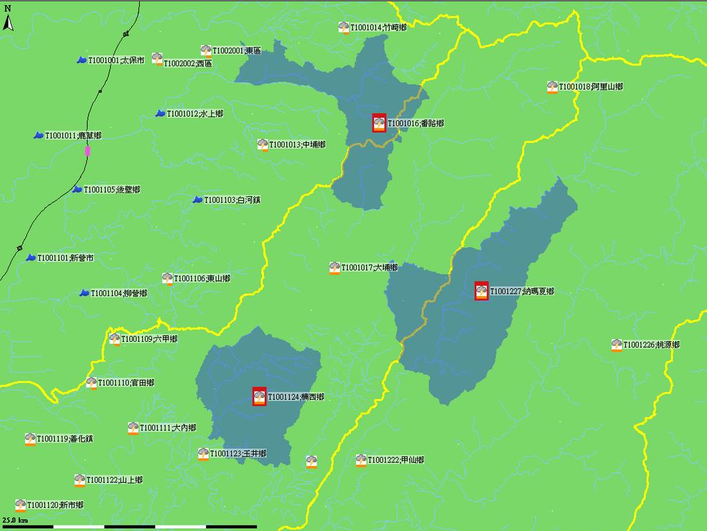
40 BASINS with Forecast Main Basin: Forecast Basin River water level station 156 station 127 Forecast Location
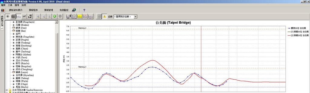

41 FEWS_TAIWAN
42 PROGRESS AND RESULTS Based on General Adaptor SOBEK RR-CF 23 basin KW-GIUH RR 1 basin NCHC-Sacramento RR 3 basin NCHC-RTEC (Real Time Error Correction ) 23 basin Shihmen-ANN inflow PMWIN (groundwater) 2 area

43 DIFFERENT CATCHMENTS FOR RAINFALL RUNOFF Main Station Sub basin Thiessen Polygon


44 USE OPENEARTH METHOD DISPLAY QPE DATA

45 3D COUNTRY RAINFALL DATA

46 HYDROLOGICAL MONITORING BOARD A widget-like program to automatically display water level observed and forecasting Water level stations Observed water level Forecasting water level

47 COMPUTING TUNE-UP 23 basins & rivers Forecast hourly Before tune-up : a full run needs 20~30min After tune-up : a full run need 12~15min


48 FLOOD EVEN RECORD WALL Photo From Dr. Ching-Fang, Lee
49 THANKS FOR YOUR ATTENTION.
Statistical Characteristic of Heavy Rainfall Associated with Typhoons near Taiwan Based on the High-Density Automatic Rain Gauge Data
 1 2 Statistical Characteristic of Heavy Rainfall Associated with Typhoons near Taiwan Based on the High-Density Automatic Rain Gauge Data 3 4 Chun-Chieh Wu 1, Tzu-Hsiung Yen 1, Yi-Hsuan Huang 1, Cheng-Ku
Understanding disaster risk ~ Lessons from 2009 Typhoon Morakot, Southern Taiwan
 Understanding disaster risk ~ Lessons from 2009 Typhoon Morakot, Southern Taiwan Wen Chi Lai, Chjeng-Lun Shieh Disaster Prevention Research Center, National Cheng-Kung University 1. Introduction 08/10
Bias correction of Dynamic Downscaled Typhoons Rainfall Data for Hydrological Applications
 Bias correction of Dynamic Downscaled Typhoons Rainfall Data for Hydrological Applications National Science and Technology Center for Disaster Reduction Dr. Yuan-Fong Su 27 May 2015 2015 International
THE CASE STUDY OF DEBRIS FLOW hazard CAUSED BY TYPHOON MORAKOT IN TAIWAN, 2009
 DOI: 10.4408/IJEGE.2011-03.B-076 THE CASE STUDY OF DEBRIS FLOW hazard CAUSED BY TYPHOON MORAKOT IN TAIWAN, 2009 Meei-Ling LIN (*), Kuo-Lung WANG (*), Tien-Chien CHEN (**) & Shen-Chi LIN (***) (*) Department
U.S.-Taiwan Workshop on the Advancement of Societal Responses to Mega-Disasters afflicting Mega-Cities. Introduction of Taiwan Typhoon and
 U.S.-Taiwan Workshop on the Advancement of Societal Responses to Mega-Disasters afflicting Mega-Cities Introduction of Taiwan Typhoon and Flood Research Institute Ching-Yuang Huang TTFRI On behalf of Cheng-Shang
A Roundup of Recent Debris Flow Events in Taiwan
 2015 International Workshop on Typhoon and Flood APEC Experience Sharing on Hazardous Weather Events and Risk Management A Roundup of Recent Debris Flow Events in Taiwan Hsiao-Yuan(Samuel) Yin Ph.D. sammya@mail.swcb.gov.tw
A Numerical Method for Determine the Dredging Requirements for Channel Restoration Using Alishan Creek in Central Taiwan as an Example
 A Numerical Method for Determine the Dredging Requirements for Channel Restoration Using Alishan Creek in Central Taiwan as an Example Instructors : Dr. Jie-Dar Cheng Dr. Honglay Chen Dr. Chao-Yuan Lin
Trends of Tropical Cyclone and China Summer Monsoon Extreme Rainfall and Taiwan Typhoon Rain Intensity
 Trends of Tropical Cyclone and China Summer Monsoon Extreme Rainfall and Taiwan Typhoon Rain Intensity C.P. Chang 1, 2, C.H. Sui 1, H.C. Kuo 1, YH Lei 3, Y.T. Yang 1, XH Lin 4, and FM Ren 5 1 National
Outline. Research Achievements
 Taiwan Typhoon and Flood Research Institute, National Applied Research Laboratories 11F., No.97, Sec. 1, Roosevelt Rd., Zhongzheng Dist., Taipei City 10093, Taiwan (R.O.C.) http://www.ttfri.narl.org.tw/eng/index.html
Record Breaking Increase in Taiwan Typhoon Rainfall in the Recent Decade: Is it Related to Global Warming?
 Record Breaking Increase in Taiwan Typhoon Rainfall in the Recent Decade: Is it Related to Global Warming? C.P. Chang 1,2, Y.T. Yang 1,H.C. Kuo 1, C.H. Sui 1, YH. Lei 3, XH. Lin 4, and FM. Ren 5 1 Department
Date : 2018/10/18 Presenter : Yu-Cheng Tai Advisor : Chyi-Tyi Lee
 The exploration of the relation among landslide susceptibility, probability of failure and rainfall by using independent events - Lanyang catchment and neighboring area for a case study Date : 2018/10/18
Striving Sufficient Lead Time of Flood Forecasts via Integrated Hydro-meteorological Intelligence
 Striving Sufficient Lead Time of Flood Forecasts via Integrated Hydro-meteorological Intelligence Dong-Sin Shih Assistant Professor, National Chung Hsing University, Taiwan, Sep. 6, 2013 Outlines Introductions
GIS Application in Landslide Hazard Analysis An Example from the Shihmen Reservoir Catchment Area in Northern Taiwan
 GIS Application in Landslide Hazard Analysis An Example from the Shihmen Reservoir Catchment Area in Northern Taiwan Chyi-Tyi Lee Institute of Applied Geology, National Central University, No.300, Jungda
Taipei MRT protection measures Typhoon Nari lessens and responses
 Taipei MRT protection measures Typhoon Nari lessens and responses Tsang-Jung Chang and Tsung-Yi Pan Hydrotech Research Institute, Center for Weather Climate and Disaster Research, National Taiwan University
New Conceptual Model of Large-Scale Landslide
 The Second Global Summit of Research Institutes for Disaster Risk Reduction Development of a Research Road Map for the Next Decade March 19-20, 2015 New Conceptual Model of Large-Scale Landslide Reported
An Impact Study of GPS RO Data on the Typhoon Track Forecast using the CWB Global Forecast System
 An Impact Study of GPS RO Data on the Typhoon Track Forecast using the CWB Global Forecast System Ming-Jen Yang 1, Yu-Chun Chen 2,1, Yen-Chih Shen 2, Chin-Tzu Fong 2, and Wen-Mei Chen 2 1 National Central
Flash Flood Guidance System On-going Enhancements
 Flash Flood Guidance System On-going Enhancements Hydrologic Research Center, USA Technical Developer SAOFFG Steering Committee Meeting 1 10-12 July 2017 Jakarta, INDONESIA Theresa M. Modrick Hansen, PhD
EFFICIENCY OF THE INTEGRATED RESERVOIR OPERATION FOR FLOOD CONTROL IN THE UPPER TONE RIVER OF JAPAN CONSIDERING SPATIAL DISTRIBUTION OF RAINFALL
 EFFICIENCY OF THE INTEGRATED RESERVOIR OPERATION FOR FLOOD CONTROL IN THE UPPER TONE RIVER OF JAPAN CONSIDERING SPATIAL DISTRIBUTION OF RAINFALL Dawen YANG, Eik Chay LOW and Toshio KOIKE Department of
Hui Hsuan Yang, Su Ying Chen, Sung Ying Chien, and Wei Sen Li
 NCDR 102-T28 Forensic Investigation of Typhoon Morakot Disaster: Nansalu and Daniao Village Case Study Hui Hsuan Yang, Su Ying Chen, Sung Ying Chien, and Wei Sen Li 2014.05 Contents CONTENTS... I TABLES....
FORECAST-BASED OPERATIONS AT FOLSOM DAM AND LAKE
 FORECAST-BASED OPERATIONS AT FOLSOM DAM AND LAKE 255 237 237 237 217 217 217 200 200 200 0 163 131 Bridging the Gap163Conference 255 0 132 255 0 163 122 The Dana on Mission Bay San Diego, CA January 28,
TRANSBOUNDARY FLOOD FORECASTING THROUGH DOWNSCALING OF GLOBAL WEATHER FORECASTING AND RRI MODEL SIMULATION
 TRANSBOUNDARY FLOOD FORECASTING THROUGH DOWNSCALING OF GLOBAL WEATHER FORECASTING AND RRI MODEL SIMULATION Rashid Bilal 1 Supervisor: Tomoki Ushiyama 2 MEE15624 ABSTRACT The study comprise of a transboundary
Non-structural Countermeasures against Debris Flow Disaster in Taiwan
 Non-structural Countermeasures against Debris Flow Disaster in Taiwan Wang,Chin-Lun Ph.D, Deputy Director General Soil and Water Conservation Bureau Council of Agriculture, Executive Yuan, Taiwan August
Temporal and spatial responses of river discharge to tectonic and climatic perturbations: Choshui River, Taiwan, and Typhoon Mindulle (2004)
") doi:10.5194/piahs-367-29-2015 Sediment Dynamics from the Summit to the Sea 29 (Proceedings of a symposium held in New Orleans, Louisiana, USA, 11 14 December 2014) (IAHS Publ. 367, 2014). Temporal and
doi:10.5194/piahs-367-29-2015 Sediment Dynamics from the Summit to the Sea 29 (Proceedings of a symposium held in New Orleans, Louisiana, USA, 11 14 December 2014) (IAHS Publ. 367, 2014). Temporal and
Research Article Applications of Cluster Analysis and Pattern Recognition for Typhoon Hourly Rainfall Forecast
 Hindawi Advances in Meteorology Volume 217, Article ID 519646, 17 pages https://doi.org/1.1155/217/519646 Research Article Applications of Cluster Analysis and Pattern Recognition for Typhoon Hourly Rainfall
Incorporation of SMOS Soil Moisture Data on Gridded Flash Flood Guidance for Arkansas Red River Basin
 Incorporation of SMOS Soil Moisture Data on Gridded Flash Flood Guidance for Arkansas Red River Basin Department of Civil and Environmental Engineering, The City College of New York, NOAA CREST Dugwon
Impact of FORMOSAT 3/COSMIC Radio Occultation. near Taiwan
 Impact of FORMOSAT 3/COSMIC Radio Occultation Data on Predictions i of Typhoon and Mei yu Fronts near Taiwan CHING YUANG HUANG 1,2, CHAN SENG WONG 1, CHIEN JU WANG 2, and CHIN CHENG TSAI 2 1 Department
FLORA: FLood estimation and forecast in complex Orographic areas for Risk mitigation in the Alpine space
 Natural Risk Management in a changing climate: Experiences in Adaptation Strategies from some European Projekts Milano - December 14 th, 2011 FLORA: FLood estimation and forecast in complex Orographic
An Overview of Operations at the West Gulf River Forecast Center Gregory Waller Service Coordination Hydrologist NWS - West Gulf River Forecast Center
 National Weather Service West Gulf River Forecast Center An Overview of Operations at the West Gulf River Forecast Center Gregory Waller Service Coordination Hydrologist NWS - West Gulf River Forecast
FLO-2D Simulation of Mudflow Caused by Large Landslide Due to Extremely Heavy Rainfall in Southeastern Taiwan during Typhoon Morakot
 FLO-2D Simulation of Mudflow Caused by Large Landslide Due to Extremely Heavy Rainfall in Southeastern Taiwan during Typhoon Morakot PENG Szu-Hsien 1*, LU Shih-Chung 1 Department of Spatial Design, Chienkuo
Results of Intensity-Duration- Frequency Analysis for Precipitation and Runoff under Changing Climate
 Results of Intensity-Duration- Frequency Analysis for Precipitation and Runoff under Changing Climate Supporting Casco Bay Region Climate Change Adaptation RRAP Eugene Yan, Alissa Jared, Julia Pierce,
Folsom Dam Water Control Manual Update
 Folsom Dam Water Control Manual Update Public Workshop April 3, 2014 Location: Sterling Hotel Ballroom 1300 H Street, Sacramento US Army Corps of Engineers BUILDING STRONG WELCOME & INTRODUCTIONS 2 BUILDING
Haiti and Dominican Republic Flash Flood Initial Planning Meeting
 Dr Rochelle Graham Climate Scientist Haiti and Dominican Republic Flash Flood Initial Planning Meeting September 7 th to 9 th, 2016 Hydrologic Research Center http://www.hrcwater.org Haiti and Dominican
National Taiwan University
 National Taiwan University 1 1 Prof. Harold Yih-Chi Tan Director of Center for Weather Climate and Disaster Research Professor of National Taiwan University 2 2 1 3 3 Cooperation of University and Local
Eyewall Evolution of Typhoons Crossing the Philippines and Taiwan: An
 1 Eyewall Evolution of Typhoons Crossing the Philippines and Taiwan: An 2 Observational Study 3 Kun-Hsuan Chou 1, Chun-Chieh Wu 2, Yuqing Wang 3, and Cheng-Hsiang Chih 4 4 1 Department of Atmospheric Sciences,
Robert Shedd Northeast River Forecast Center National Weather Service Taunton, Massachusetts, USA
 Robert Shedd Northeast River Forecast Center National Weather Service Taunton, Massachusetts, USA Outline River Forecast Centers FEWS Implementation Status Forcing Data Ensemble Forecasting The Northeast
Large Increasing Trend of Tropical Cyclone Rainfall in Taiwan and the Roles of Terrain and Southwest Monsoon
 January 3, 2017 16:1 The Global Monsoon System: Research and Forecast (3rd Edition) - 10.25in x 7.5in b2503-ch20 page 255 255 Chapter 20 Large Increasing Trend of Tropical Cyclone Rainfall in Taiwan and
Impact of GPS RO Data on the Prediction of Tropical Cyclones
 Impact of GPS RO Data on the Prediction of Tropical Cyclones Ying-Hwa Kuo, Hui Liu, UCAR Ching-Yuang Huang, Shu-Ya Chen, NCU Ling-Feng Hsiao, Ming-En Shieh, Yu-Chun Chen, TTFRI Outline Tropical cyclone
Challenges in providing effective flood forecasts and warnings
 Challenges in providing effective flood forecasts and warnings National Centre for Flood Research Inaugural Symposium Justin Robinson Bureau of Meteorology October 2018 Zero Lives Lost A key responsibility
FFGS Additional Functionalities and Products. Konstantine P. Georgakakos, Sc.D. HYDROLOGIC RESEARCH CENTER 23 May 2018
 FFGS Additional Functionalities and Products Konstantine P. Georgakakos, Sc.D. HYDROLOGIC RESEARCH CENTER 23 May 2018 Advanced Functionalities 0. Multi-Model QPF A. Urban Flash Flood Warning B. Riverine
To facilitate efficiency of emergency operations through integrating knowledge and information for decision makers
 To facilitate efficiency of emergency operations through integrating knowledge and information for decision makers Hongey Chen Director National Science and Technology Center for Disaster Reduction (NCDR)
High Resolution (20-km Mesh) Global Climate Model and Projected Hydro- Meteorological Extremes in the Future. Akio Kitoh
 Global Climate Model and Projected Hydro- Meteorological Extremes in the Future. Akio Kitoh") 2011.6.29, U-02, IUGG, Melbourne High Resolution (20-km Mesh) Global Climate Model and Projected Hydro- Meteorological Extremes in the Future Akio Kitoh Climate Research Department Meteorological Research
2011.6.29, U-02, IUGG, Melbourne High Resolution (20-km Mesh) Global Climate Model and Projected Hydro- Meteorological Extremes in the Future Akio Kitoh Climate Research Department Meteorological Research
Folsom Dam Water Control Manual Update Joint Federal Project, Folsom Dam
 Folsom Dam Water Control Manual Update Joint Federal Project, Folsom Dam Public Workshop May 28, 2015 Library Galleria 828 I Street, Sacramento, CA US Army Corps of Engineers BUILDING STRONG WELCOME &
STUDY ON THE PRECISION OF 1-MINUTE X-BAND MP RADAR RAINFALL DATA IN A SMALL URBAN WATERSHED
 Y. Yonese, et al., Int. J. Sus. Dev. Plann. Vol. 13, No. 4 (2018) 614 625 STUDY ON THE PRECISION OF 1-MINUTE X-BAND MP RADAR RAINFALL DATA IN A SMALL URBAN WATERSHED YOSHITOMO YONESE 1, AKIRA KAWAMURA
Journal of Hydrology
 Journal of Hydrology xxx (2012) xxx xxx Contents lists available at SciVerse ScienceDirect Journal of Hydrology journal homepage: www.elsevier.com/locate/jhydrol Assessment of sewer flooding model based
Global Flash Flood Guidance System Status and Outlook
 Global Flash Flood Guidance System Status and Outlook HYDROLOGIC RESEARCH CENTER San Diego, CA 92130 http://www.hrcwater.org Initial Planning Meeting on the WMO HydroSOS, Entebbe, Uganda 26-28 September
THE DISCUSS ON THE SEDIMENT DISASTERS CAUSED REASON IN HAOCHA TRIBE AREA
 THE DISCUSS ON THE SEDIMENT DISASTERS CAUSED REASON IN HAOCHA TRIBE AREA Chun-Li Hsu 1, Shin-Yi Dai 2 * ABSTRACT From 2005 to 2008 series of typhoons and heavy rainfall makes Haocha tribe suffered serious
THE DEVELOPMENT AND APPLICATION OF THE DISPATCH MODEL FOR MOBILE DEBRIS FLOW MONITORING STATION AT TYPHOON EVENT
 THE DEVELOPMENT AND APPLICATION OF THE DISPATCH MODEL FOR MOBILE DEBRIS FLOW MONITORING STATION AT TYPHOON EVENT Chao-Hsien Yeh 1*, Bing-Jean Lin 2, Yao-Min Fang 3, Hsian-Yuan Yin 4, Hua-wei Lu 5 ABSTRACT
Recent development of the National Hydro-Meteorological Service (NHMS) of Viet Nam for disaster risk reduction
 of Viet Nam for disaster risk reduction") Ministry of Natural Resources and Environment National Hydro-Meteorological Service Recent development of the National Hydro-Meteorological Service (NHMS) of Viet Nam for disaster risk reduction Tran Van
Ministry of Natural Resources and Environment National Hydro-Meteorological Service Recent development of the National Hydro-Meteorological Service (NHMS) of Viet Nam for disaster risk reduction Tran Van
Application of Radar QPE. Jack McKee December 3, 2014
 Application of Radar QPE Jack McKee December 3, 2014 Topics Context Precipitation Estimation Techniques Study Methodology Preliminary Results Future Work Questions Introduction Accurate precipitation data
Wales real time forecasting for fast responding rivers. Andy Wall Flood Forecasting Team Leader Environment Agency Wales
 Wales real time forecasting for fast responding rivers Andy Wall Flood Forecasting Team Leader Environment Agency Wales Flood risk & forecasting in Wales Fast responding rivers 220,000 properties at
THE DEVELOPMENT OF RAIN-BASED URBAN FLOOD FORECASTING METHOD FOR RIVER MANAGEMENT PRACTICE USING X-MP RADAR OBSERVATION
 Research Paper Advances in River Engineering, JSCE, Vol.19, 2013,June THE DEVELOPMENT OF RAIN-BASED URBAN FLOOD FORECASTING METHOD FOR RIVER MANAGEMENT PRACTICE USING X-MP RADAR OBSERVATION Seongsim YOON
Detailed Storm Rainfall Analysis for Hurricane Ivan Flooding in Georgia Using the Storm Precipitation Analysis System (SPAS) and NEXRAD Weather Radar
 and NEXRAD Weather Radar") Detailed Storm Rainfall Analysis for Hurricane Ivan Flooding in Georgia Using the Storm Precipitation Analysis System (SPAS) and NEXRAD Weather Radar Ed Tomlinson, PhD and Bill Kappel Applied Weather Associates
Detailed Storm Rainfall Analysis for Hurricane Ivan Flooding in Georgia Using the Storm Precipitation Analysis System (SPAS) and NEXRAD Weather Radar Ed Tomlinson, PhD and Bill Kappel Applied Weather Associates
Speakers: NWS Buffalo Dan Kelly and Sarah Jamison, NERFC Jeane Wallace. NWS Flood Services for the Black River Basin
 Speakers: NWS Buffalo Dan Kelly and Sarah Jamison, NERFC Jeane Wallace NWS Flood Services for the Black River Basin National Weather Service Who We Are The National Oceanic and Atmospheric Administration
Pompton Lakes Dam Downstream Effects of the Floodgate Facility. Joseph Ruggeri Brian Cahill Michael Mak Andy Bonner
 Pompton Lakes Dam Downstream Effects of the Joseph Ruggeri Brian Cahill Michael Mak Andy Bonner ASFPM 2013: Overview Page 2 Overview Page 3 Overview Page 4 Overview Page 5 Overview - Historical Pompton
DEPTH-AREA-DURATION ANALYSIS IN A KOREAN RIVER BASIN
 Annual Journal of Hydraulic Engineering, JSCE, Vol.57, 213, February DEPTH-AREA-DURATION ANALYSIS IN A KOREAN RIVER BASIN Young-a SHIN 1, Kaoru TAKARA 2 and Maja OSTRIC 1 1 Student Member of JSCE, Dept.
Areal Reduction Factors for the Colorado Front Range and Analysis of the September 2013 Colorado Storm
 Areal Reduction Factors for the Colorado Front Range and Analysis of the September 2013 Colorado Storm Doug Hultstrand, Bill Kappel, Geoff Muhlestein Applied Weather Associates, LLC - Monument, Colorado
9. PROBABLE MAXIMUM PRECIPITATION AND PROBABLE MAXIMUM FLOOD
 9. PROBABLE MAXIMUM PRECIPITATION AND PROBABLE MAXIMUM FLOOD 9.1. Introduction Due to the size of Watana Dam and the economic importance of the Project to the Railbelt, the Probable Maximum Flood (PMF)
Study 16.5 Probable Maximum Flood (PMF)
") Initial Study Report Meeting Study 16.5 Probable Maximum Flood (PMF) October 22, 2014 Prepared by 10/22/2014 1 Study 16.5 Objectives Develop a site-specific PMP to be used for the derivation of the PMF
Initial Study Report Meeting Study 16.5 Probable Maximum Flood (PMF) October 22, 2014 Prepared by 10/22/2014 1 Study 16.5 Objectives Develop a site-specific PMP to be used for the derivation of the PMF
HYDRO-METEOROLOGICAL INVESTIGATION OF 2015 FLASH FLOOD IN EASTERN HILL BASIN BANGLADESH
 HYDRO-METEOROLOGICAL INVESTIGATION OF 2015 FLASH FLOOD IN EASTERN HILL BASIN BANGLADESH M.S. Hossain 1*, G. M. T. Islam 2, S. U. Raihan 1, S. M. Q. Hassan 3 & R. H. Khan 4 1 Flood Forecasting and Warning
Integrating Weather Forecasts into Folsom Reservoir Operations
 Integrating Weather Forecasts into Folsom Reservoir Operations California Extreme Precipitation Symposium September 6, 2016 Brad Moore, PE US Army Corps of Engineers Biography Brad Moore is a Lead Civil
Application of Satellite Data for Flood Forecasting and Early Warning in the Mekong River Basin in South-east Asia
 MEKONG RIVER COMMISSION Vientiane, Lao PDR Application of Satellite Data for Flood Forecasting and Early Warning in the Mekong River Basin in South-east Asia 4 th World Water Forum March 2006 Mexico City,
Author's personal copy
 Journal of Hydrology 58 (14) 374 384 Contents lists available at ScienceDirect Journal of Hydrology journal homepage: www.elsevier.com/locate/jhydrol Watershed rainfall forecasting using neuro-fuzzy networks
Estimating Design Rainfalls Using Dynamical Downscaling Data
 Estimating Design Rainfalls Using Dynamical Downscaling Data Ke-Sheng Cheng Department of Bioenvironmental Systems Engineering Mater Program in Statistics National Taiwan University Introduction Outline
Central Water Commission Ministry of WR,RD & GR. Operational Flood Forecasting
 Central Water Commission Ministry of WR,RD & GR 1 Operational Flood Forecasting Flood Forecasting by CWC 2 The work of flood forecasting and warning in India is entrusted with the Central Water Commission
Joint Meeting of RA II WIGOS Project and RA V TT-SU on 11 October 2018 BMKG Headquarter Jakarta, Indonesia. Mrs. Sinthaly CHANTHANA
 Joint Meeting of RA II WIGOS Project and RA V TT-SU on 11 October 2018 BMKG Headquarter Jakarta, Indonesia Mrs. Sinthaly CHANTHANA Lao PDR Background Department of Meteorology and Hydrology ( DMH ) in
Use of Geospatial data for disaster managements
 Use of Geospatial data for disaster managements Source: http://alertsystemsgroup.com Instructor : Professor Dr. Yuji Murayama Teaching Assistant : Manjula Ranagalage What is GIS? A powerful set of tools
Landslide Disaster Management in Sri Lanka and Nichola Oya as a Case study. Group 16 Gamini Jayathissa Udeni Nawagamuwa
 Landslide Disaster Management in Sri Lanka and Nichola Oya as a Case study Group 16 Gamini Jayathissa Udeni Nawagamuwa Taiwan Sri lanka >2582 mm, max >5000mm NE= Nov. to Feb 1750 2500 mm >2500 mm Central
Flash Flood Guidance: SARFFG modeling system
 Flash Flood Guidance: SARFFG modeling system Eugene Poolman Chief Forecasting: Disaster Risk Reduction RSMC Pretoria FCAST-PRES-20141021-001.1 Flash Floods vs. River Floods River floods are caused by heavy
ENGINEERING HYDROLOGY
 ENGINEERING HYDROLOGY Prof. Rajesh Bhagat Asst. Professor Civil Engineering Department Yeshwantrao Chavan College Of Engineering Nagpur B. E. (Civil Engg.) M. Tech. (Enviro. Engg.) GCOE, Amravati VNIT,
Preliminary assessment of socio-economic benefits from CMA Meteorological Satellite Programmes. Dr. ZHENG Guoguang / YANG Jun
 Preliminary assessment of socio-economic benefits from CMA Meteorological Satellite Programmes Dr. ZHENG Guoguang / YANG Jun China Meteorological Administration CMA report to CM-12 WMO HQ, June 21, 2014
The Impacts of GPS Radio Occultation Data on the Analysis and Prediction of Tropical Cyclones. Bill Kuo, Xingqin Fang, and Hui Liu UCAR COSMIC
 The Impacts of GPS Radio Occultation Data on the Analysis and Prediction of Tropical Cyclones Bill Kuo, Xingqin Fang, and Hui Liu UCAR COSMIC GPS Radio Occultation α GPS RO observations advantages for
URBAS Prediction and management of flash floods in urban areas
 URBAS Prediction and management of flash floods in urban areas 1 Thomas Einfalt, Klaus Friedeheim, Andreas Wagner Project funded by the Federal Ministry of Education and Research BMBF (Germany) as a part
Areal Reduction Factors for the Colorado Front Range and Analysis of the September 2013 Colorado Storm
 Areal Reduction Factors for the Colorado Front Range and Analysis of the September 2013 Colorado Storm Doug Hultstrand, Bill Kappel, Geoff Muhlestein Applied Weather Associates, LLC - Monument, Colorado
Enhancing Regional Digital Preparedness on Natural Hazards The Application of Science and Technology in DRR Decision Making
 Enhancing Regional Digital Preparedness on Natural Hazards The Application of Science and Technology in DRR Decision Making Hongey Chen, Director Wei Sen Li, Secretary General National Sceince and Technology
On the use of radar rainfall estimates and nowcasts in an operational heavy rainfall warning service
 On the use of radar rainfall estimates and nowcasts in an operational heavy rainfall warning service Alan Seed, Ross Bunn, Aurora Bell Bureau of Meteorology Australia The Centre for Australian Weather
Solution: The ratio of normal rainfall at station A to normal rainfall at station i or NR A /NR i has been calculated and is given in table below.
 3.6 ESTIMATION OF MISSING DATA Data for the period of missing rainfall data could be filled using estimation technique. The length of period up to which the data could be filled is dependent on individual
CIVIL ENGINEERING. Engineering Hydrology RIB-R T11 RIB. Detailed Explanations. Rank Improvement Batch ANSWERS. RIB(R)-18 CE Engineering Hydrology
-18 CE Engineering Hydrology") RIB-R T11 RIB Rank Improvement Batch Session 18-1 S.No. : 118_SK CIVIL ENGINEERING Engineering Hydrology ANSWERS 1. (b) 7. (c) 1. (c) 1. (b). (d). (c) 8. (a) 1. (a). (b). (c). (a). (d) 1. (c) 1. (a) 7.
RIB-R T11 RIB Rank Improvement Batch Session 18-1 S.No. : 118_SK CIVIL ENGINEERING Engineering Hydrology ANSWERS 1. (b) 7. (c) 1. (c) 1. (b). (d). (c) 8. (a) 1. (a). (b). (c). (a). (d) 1. (c) 1. (a) 7.
Rapid Flood Evaluation Systems in Taiwan Metropolitan Areas
 SPOTLIGHT: Information Automation and Disaster Responses Guest edited by Kuang-Chong Wu Rapid Flood valuation Systems in Taiwan Metropolitan Areas Wen-Dar Guo*, Wei-Sheng Feng, Yu-chi Wang, and Hsin-Ya
The Variation of Sediment Discharge During Flood Period
 The Variation of Sediment Discharge During Flood Period Yu-Chieh LIN 1, Yu-Min WANG 2*, and Shaing-Min CHEN 3 1 PHD student, Dept. of Civil Engineering, Pingtung University of Science and Technology E-mail:
Rapid Hazard Assessment of Heavy Rainfall Triggered Landslide Dams A Review
 Rapid Hazard Assessment of Heavy Rainfall Triggered Landslide Dams A Review Focus on the developed technologies in Taiwan J. J. Dong Graduate Institute of Applied Geology, National Central University,
NRC Workshop Probabilistic Flood Hazard Assessment (PFHA) Jan 29-31, Mel Schaefer Ph.D. P.E. MGS Engineering Consultants, Inc.
 Jan 29-31, Mel Schaefer Ph.D. P.E. MGS Engineering Consultants, Inc.") Stochastic Event Flood Model (SEFM) Stochastic Modeling of Extreme Floods A Hydrological Tool for Analysis of Extreme Floods Mel Schaefer Ph.D. P.E. MGS Engineering Consultants, Inc. Olympia, WA NRC Workshop
Stochastic Event Flood Model (SEFM) Stochastic Modeling of Extreme Floods A Hydrological Tool for Analysis of Extreme Floods Mel Schaefer Ph.D. P.E. MGS Engineering Consultants, Inc. Olympia, WA NRC Workshop
EFFECT OF TWO SUCCESIVE CHECK DAMS ON DEBRIS FLOW DEPOSITION
 DOI: 10.4408/IJEGE.2011-03.B-116 EFFECT OF TWO SUCCESIVE CHECK DAMS ON DEBRIS FLOW DEPOSITION Farouk Maricar (*), Haruyuki Hashimoto (*), Shinya Ikematsu (*) & Tomohiro Miyoshi (*) (*) Department of Civil
Overview and purposes of the meeting
 Overview and purposes of the meeting 1 Flash Floods vs. River Floods Riverine Flooding: is caused by heavy rainfall (and/or snow melt) over long periods e.g., days, leading to rising water levels and flooding
Operational Hydrologic Ensemble Forecasting. Rob Hartman Hydrologist in Charge NWS / California-Nevada River Forecast Center
 Operational Hydrologic Ensemble Forecasting Rob Hartman Hydrologist in Charge NWS / California-Nevada River Forecast Center Mission of NWS Hydrologic Services Program Provide river and flood forecasts
Souris River Basin Spring Runoff Outlook As of March 1, 2019
 Souris River Basin Spring Runoff Outlook As of March 1, 2019 Prepared by: Flow Forecasting & Operations Planning Water Security Agency Basin Conditions Summer rainfall in 2018 over the Saskatchewan portion
ON THE CORRELATION OF SEDIMENTATION AND LANDSLIDES IN WU RIVER CATCHMENT INFLUENCED BY THE 1999 CHI-CHI EARTHQUAKE
 ON THE CORRELATION OF SEDIMENTATION AND LANDSLIDES IN WU RIVER CATCHMENT INFLUENCED BY THE 1999 CHI-CHI EARTHQUAKE Keh-Jian Shou 1*, Li-Yuan Fei 2, Jiin-Fa Lee 2, Cheng-Yueh Wei 2, Chiu-Ching Wu 1, Chia-Yue
A distributed runoff model for flood prediction in ungauged basins
 Predictions in Ungauged Basins: PUB Kick-off (Proceedings of the PUB Kick-off meeting held in Brasilia, 2 22 November 22). IAHS Publ. 39, 27. 267 A distributed runoff model for flood prediction in ungauged
Journal of Hydrology
 Journal of Hydrology 506 (2013) 101 113 Contents lists available at ScienceDirect Journal of Hydrology journal homepage: www.elsevier.com/locate/jhydrol Assessment of sewer flooding model based on ensemble
COUNTRY PRESENTATION ON MR JAYNAL ABEDIN JOINT SECRETARY ( WORKS & DEVELOPMENT ) MINISTRY OF DEFENCE
 MINISTRY OF DEFENCE") COUNTRY PRESENTATION ON By MR JAYNAL ABEDIN JOINT SECRETARY ( WORKS & DEVELOPMENT ) MINISTRY OF DEFENCE Bangladesh Geographical Location of Bangladesh Bangladesh Country at a Glance Physical Features 1,230
COUNTRY PRESENTATION ON By MR JAYNAL ABEDIN JOINT SECRETARY ( WORKS & DEVELOPMENT ) MINISTRY OF DEFENCE Bangladesh Geographical Location of Bangladesh Bangladesh Country at a Glance Physical Features 1,230
How to integrate wetland processes in river basin modeling? A West African case study
 How to integrate wetland processes in river basin modeling? A West African case study stefan.liersch@pik-potsdam.de fred.hattermann@pik-potsdam.de June 2011 Outline Why is an inundation module required?
EFFECTIVE DAM OPERATION METHOD BASED ON INFLOW FORECASTING FOR SENANAYAKA SAMUDRA RESERVOIR, SRI LANKA
 EFFECTIVE DAM OPERATION METHOD BASED ON INFLOW FORECASTING FOR SENANAYAKA SAMUDRA RESERVOIR, SRI LANKA Muthubanda Appuhamige Sanath Susila GUNASENA (MEE13632) Supervisors: Dr. Mamoru Miyamoto, Dr. Duminda
8 Current Issues and Research on Sediment Movement in the River Catchments of Japan
 8 Current Issues and Research on Sediment Movement in the River Catchments of Japan YUTAKA ICHIKAWA INTRODUCTION Prediction of sediment movement is one of the challenging tasks in water-related research.
Inflow forecasting for lakes using Artificial Neural Networks
 Flood Recovery Innovation and Response III 143 Inflow forecasting for lakes using Artificial Neural Networks R. K. Suryawanshi 1, S. S. Gedam 1 & R. N. Sankhua 2 1 CSRE, IIT Bombay, Mumbai, India 2 National
Parameter Automatic Calibration Approach for Neural-Network-Based Cyclonic Precipitation Forecast Models
 Water 2015, 7, 3963-3977; doi:10.3390/w7073963 Article OPEN ACCESS water ISSN 2073-4441 www.mdpi.com/journal/water Parameter Automatic Calibration Approach for Neural-Network-Based Cyclonic Precipitation
Large Increasing Trend of Tropical Cyclone Rainfall in Taiwan and the Roles of Terrain
 4138 J O U R N A L O F C L I M A T E VOLUME 26 Large Increasing Trend of Tropical Cyclone Rainfall in Taiwan and the Roles of Terrain CHIH-PEI CHANG Department of Atmospheric Sciences, National Taiwan
Caribbean Early Warning System Workshop
 Caribbean Early Warning System Workshop Hamonization in Existing EWS April 14-16, 2016 Presenter: Shawn Boyce Caribbean Institute for Meteorology and Hydrology Husbands, St. James Barbados Background Between
FFGS Advances. Initial planning meeting, Nay Pyi Taw, Myanmar February, Eylon Shamir, Ph.D,
 FFGS Advances Initial planning meeting, Nay Pyi Taw, Myanmar 26-28 February, 2018 Eylon Shamir, Ph.D, EShamir@hrcwater.org Hydrologic Research Center San Diego, California FFG System Enhancements The following
Study 16.5 Probable Maximum Flood (PMF)
") Initial Study Report Meeting Study 16.5 Probable Maximum Flood (PMF) March 30, 2016 Prepared by 3/30/2016 1 Study 16.5 Status ISR documents (ISR Part D Overview): Status: Initial Study Report: Parts A,
Initial Study Report Meeting Study 16.5 Probable Maximum Flood (PMF) March 30, 2016 Prepared by 3/30/2016 1 Study 16.5 Status ISR documents (ISR Part D Overview): Status: Initial Study Report: Parts A,
Using rainfall thresholds and ensemble precipitation forecasts to issue and improve urban inundation alerts
 Hydrol. Earth Syst. Sci., 20, 4731 4745, 2016 doi:10.5194/hess-20-4731-2016 Author(s) 2016. CC Attribution 3.0 License. Using rainfall thresholds and ensemble precipitation forecasts to issue and improve
Flood Hazard Vulnerability Mapping Using Remote Sensing and GIS: A Case Study of Surat Dhruvesh KM 1*, Praful MU 2 and Aditya MV 1 1
 Flood Hazard Vulnerability Mapping Using Remote Sensing and GIS: A Case Study of Surat Dhruvesh KM 1*, Praful MU 2 and Aditya MV 1 1 CU Shah University, Wadhwan, India 2 ISTAR-CVM, Vallabh Vidyanagar,