FLIGHT FOLDER. Flight No. B403 Date: 22/09/08 Take Off: 07:48:00 Landing: 12:50:07 Flight Time 5h 02m 07s. Campaign: Operating Area:
|
|
|
- Kerry Whitehead
- 5 years ago
- Views:
Transcription

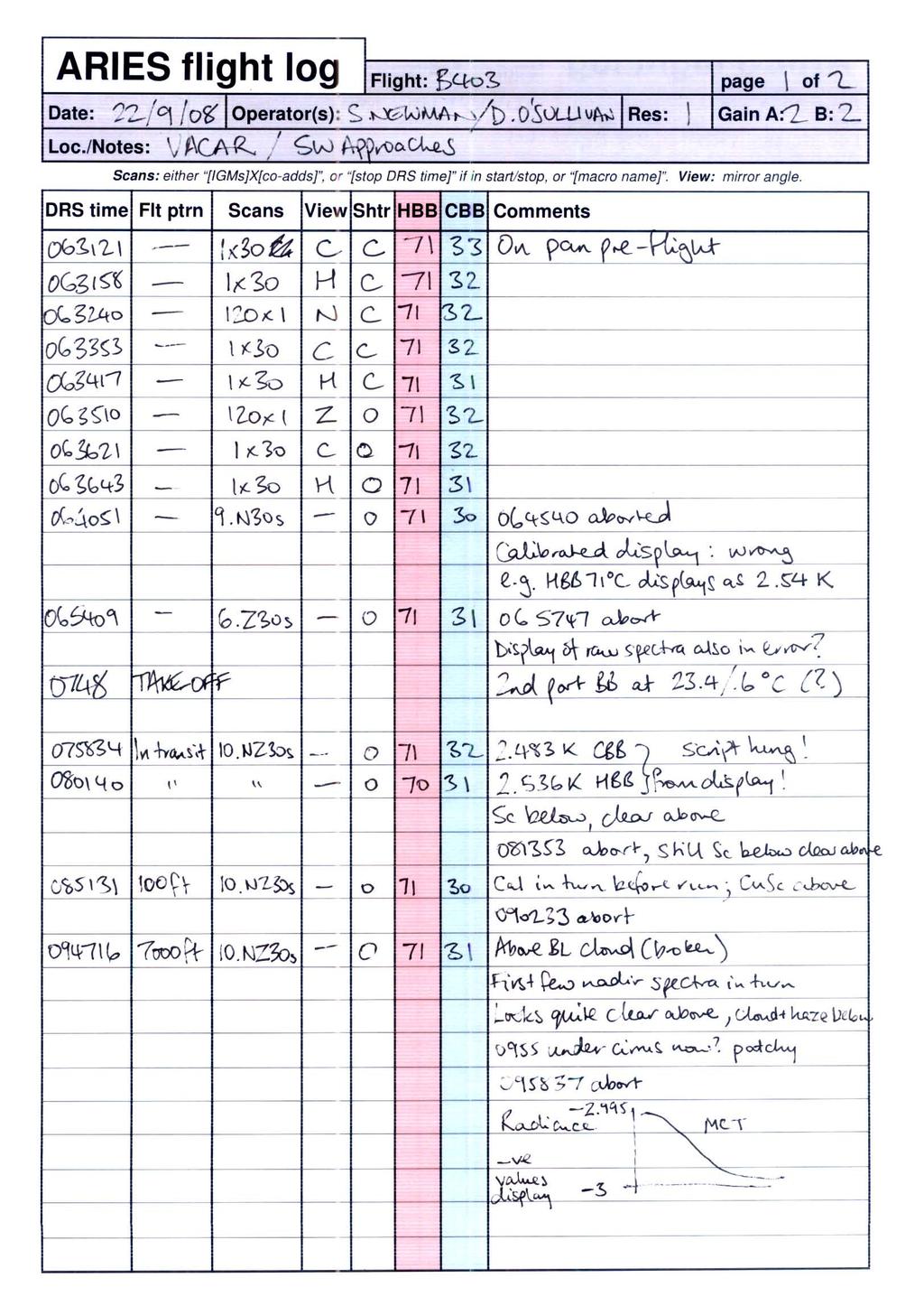
1 FLIGHT FOLDER Campaign: VACAR Flight No. B403 Date: 22/09/08 Take Off: 07:48:00 Landing: 12:50:07 Flight Time 5h 02m 07s Operating Area: SW Approaches POB Position Name Institute Logs y/n 1 Captain Alan Foster Directflight 2 Co-pilot Luc Lathouwers Directflight 3 CCM1 Gaynor Ottaway Directflight 4 Mission Scientist Chawn Harlow Met Office 5 Flight Manager Steve Devereau FAAM 6 Core Chem / AVAPS / CCM2 Doug Anderson FAAM 7 Cloud Physics Phil Rosenberg FAAM 8 ARIES / Wet Neph / PSAP Stuart Newman Met Office 9 ARIES Debbie O Sullivan Met Office 10 Wet Neph / SHIMS Andy Wilson Met Office 11 CVI / FWVS Jeff Norwood-Brown Met Office 12 TAFTS Ralph Beeby Imperial College 13 MARSS/DEIMOS / Mission Scientist 2 Dave Pollard Met Office Flight Track:
2 FLIGHT SUMMARY Flight No B403 Date: 22nd September 2008 Project: VACAR Location: SW Approaches Start End Time Time Event Height (s) Hdg Comments Start-Up 0.00 kft '04.36N, 0'37.48W Start-Up 0.00 kft 003 engine start event 0.00 kft 009 start taxy T/O 0.00 kft 282 Cranfield event 7.2 kft 275 Nevzorov, JW zero event 10.0 kft 055 Nevzorov, JW zero event 20.0 kft 255 Nevzorov, JW zero event 20.0 kft 255 JW zero Profile kft event 18.7 kft 267 extend BBR event 4.4 kft 261 JW zero event 1.6 kft 261 retract BBR Run kft 178 Heimann cal Profile kft event 0.76 kft 344 bbr extend Profile kft Profile kft Profile kft Profile kft event 0.36 kft 008 Nevzorov, JW zero event 7.0 kft 279 bbr retract Run kft event 7.0 kft 008 Nevzorov, JW zero Profile kft Run kft Sonde kft Run kft 352 contrailing at FL Sonde kft Run kft Sonde kft event 33.7 kft 196 Nevzorov, JW zero Sonde kft Profile kft Profile kft Profile kft Profile kft Profile kft fpm event -.02 kft 050 Nevzorov, JW zero
3 Land 0.00 kft Shutdown 0.00 kft 306 at Cranfield

4
5
6 VACAR -Variational Assimilation of Cloud Affected Radiances. Cirrus with stratocumulus or broken cumulus below and IASI overpass at 1045Z Aim To gather a data set that can be used to test the 1d-var assimilation of cloud affected ARIES and/or IASI spectra. Measurement Requirement 1. Profiles of temperature, water vapour and ozone, 2. Measure of the sea surface temperature and emissivity and surface wind speed 3. Measurements of the physical position of the clouds e.g. cloud top and base altitude and temperature 4. Measurements of the cloud microphysical properties vertical structure and horizontal variability 5. Measurements of ARIES, SWS and MARSS spectra looking down through clouds and upwards above clouds. 6. Dropsondes through the atmosphere during high level runs above clouds. 7. Ideally coincident with IASI satellite overpass during high level runs. Sortie structure 1. Take off and transit to area profiling to arrive at 50ft (45 mins) 2. Straight and level run at 100ft over fixed ground positions oriented to cross sub-satellite track diagonally if near nadir or at angle ~30deg off satellite track for runs further away from sub satellite track (10 mins, 55 total) 3. Profile to level above cloud tops (10 mins, 65 total) 4. If Stratocumulus then: A series of saw tooth profiles crossing the cloud top boundary from 1000ft above cloud to 1000ft below cloud tops (60 mins) If broken cumulus then: A series of saw tooth profiles from 1000ft above cloud tops to 1000ft below cloud base adjust some profiles to ensure that some pass through cloud and others through the breaks (60 mins, 140 total) 5. Straight and level run above boundary layer cloud (10 mins, 135 total) 6. Profile to level safely above cirrus clouds (30 mins, 165 total) 7. Two straight and level runs above cirrus clouds, one to be coincident with IASI overpass at 1045Z, launch two sondes on each run, run duration 10 mins (25 mins, 190 total) 8. Series of saw tooth profiles through the cirrus from above cloud to 1000ft below cloud (60 mins, 250 total) 9. Profile to lowest permitted altitude stepping to remain in same geographic area (30 mins, 280 total) 10. Transit back to Cranfield (45 mins, 325 total)
7 Cirrus Clouds Stratocumulus Sea Surface Time Cirrus Clouds Broken Cumulus Sea Surface Time
8 B403 Flight Debrief Campaign: VACAR Mission Scientist: Chawn Harlow Decision for go/no-go were complicated by slow MO computing facilities at FAAM. Prior to flight both areas A and C were holding promise for a mixed SCu/Ci VACAR sortie. Decision for area A were based on easier low level operation in SW Approaches. Models and satellite images were showing good SCu/Cu in NW portions of area A (south of Irish FIR) with some Ci forecast to arrive during the early part of the sortie. The conditions for this VACAR sortie were slightly marginal. However, discussions with the PI on the project have confirmed that this is likely to be a good case. There was a fairly good deck of broken Cu between 1000 and 7000, but the Ci overhead was fairly variable in space and time with the overall cover increasing between the low level and high level work. During low level work the Ci appeared to be constrained to the N ern half of the SLR at The instruments worked beyond expectations throughout with several profiles through the low level cloud layer and three through the Ci. The aircraft was in position in the high level run during the 1045Z IASI overpass. Profiles where at 500 fpm in the boundary layer and 1000 fpm above except in the last descending profile. During this latter profile from FL330 to 50, the rate of descent was increased during the cloud-free portion down to the top of the boundary layer due to fuel constraints. After transiting to the operating area, a profile descent was carried out from FL200 to 50 above the sea. A straight and level run (SLR) was carried out at 100 above the sea surface to sample sea surface temperature and emissivity as well as the low level wind conditions. Broken Cu were observed above on the whole of this run. A profile was then carried out to 4000 during which cloud bases and tops where at approximately 1000 and 3200 asl, respectively. Two profiles were performed from 1000 above cloud top to 50 and back up again. The final of the saw-tooth profiles was terminated at 7000 as the cloud appeared to have grown during the saw-teeth. An SLR was carried out at 7000 followed by a profile up to FL 340 during which thin Ci was observed between FL 280 and FL 310. two SLR s were then performed at FL340 coincident with the satellite overpass and launching two sondes on each. A saw-tooth profile was then carried out from FL 340 to FL 270 and back up again. One final deep profile was then carried out to 50 with the above mentioned steep descent before transiting back to Cranfield.
9
10
11
12
13 CLOUD PHYSICS LOG Flight B403 Date:22/09/08 Operator:PDR DRS time: DAU1 time: DAU2 time: DAU3 time: AUX1 time: AUX2 time: Page 1 of 1 Pcasp vref 7.5, flow 0.82, ffssp vref 3.3, 2dc end elements 1.3,1.4 G.M.T PCASP FFSSP SID1 SID2 2D2-C 2D2-P CIP25 CIP100 Habit Remarks Conc/c c Mean R Block TX Count Count Conc/L Max size Conc/m3 Max size Conc m3 Max size LWC Conc m3 Max size LWC Not running 2dp Start profil e :33: :38: Entered boundary layer at ~fl 70 08:43: Fl 30 08:45: Fl 23 08:45: Fl 16 passed through cloud 08:47: Fl 10 08:49:00 Possible noise spikes seen on pcasp ch1 correlating with sapikes in ffssp strobe counts 08:51: ft end profile 1.1 Start ru n :55: :59: :02: End run 1.1 Start Profil e :06: Fl 15 some cloud penetrated 09:08: Fl 30 End profile 2.1 start profile :14: Fl 5 some cloud penetration during descent conc 10/L seen on 2dc 09:16: End profile 3.1 start profile ft 09:22: End profile 4.1 start profile :28: Fl 10 09:32: ft end profile 5.1 start profile :38: Fl 30 09:43: Fl 50 09:47: Fl70 exit boundary layer end profile 6.1 start run :56: :58: End run 2.1 start profile :05: Initial steep decrease to ~50 counts/cc on pacsp at start of ascent followed by gradual decrease to ~10 counts/cc 10:24: One spike on 2dc to 250 counts/l 10:37:00 Noise on pcasp ch1 caused by cold conditions at high alt 10:09: :14: Fl cloud layers seen by 2dc 11:18: Fl : Entered boundary layer 11:37: Fl 40 11:39: Fl30 11:44: ft MetOffice 2005
14 CLOUD PHYSICS PROCESSING LOG Flight number: B403 T/O: 07:48:00 Date of flight: 22/09/08 Land: 12:50:07 Revision date: 11/12/2008 3:22 PM A) FFSSP PROCESSING DONE IN EXETER Processing Stage Done? Comments 1) Transfer *.txt files from DVD to processing PC Bnnn_FFSSP_hh.txt for each hour of data hh = Bnnn_FFSSP_HVMS.txt Last sec processed = 2) FTP the files (ascii) from the PC to directory File size = PMSDATA: on FLOODS 3) FLOODS> RUN MRFB:[PMS.FAST_FSSP]FSSP_EXTRACT_TAS a) Flight number: Bnnn b) Path name: MFDDATA:Bnnn_MFDX c) Output directory: PMSDATA: d) Start time: 0 if unknown (see comment box) Use time just before/after take-off/landing. If T/O /landing just after/before the hour, ensure start/end time is before/after the hour if there is an FFSSP_hh.txt file for that hour. e) End time: if unknown 4) FLOODS> RUN MRFB:[PMS.FAST_FSSP]FFSSP_PROCESS_TXT a) Flight number: Bnnn b) Directory: PMSDATA: Total glitches = c) TAS in processing: Y Sec file written ok? d) Vel threshold (clicks) 0 e) Calibration file: Use the most recent calibration file. Note calibration file used Format FFSSP_CALddmmyyyy.txt Calibration files to be stored in MRFB:[PMS.FAST_FSSP] f) Adjust FFSSP time Y/N Yes only if gross errors occur g) If Y, enter value to add to data time (seconds) in FFSSP time eg; ~ 1hour 5) FLOODS> WAVE Use PVWAVE for this section a) WAVE> write_procffssp_to_m5,'pmsdata:bnnn_procffssp.dat', 'mfddata:bnnn_mfdx','pmsdata:bnnn_m5procffssp',/auto Note time correction applied to FFSSP by /auto = b) WAVE> exit 6) FLOODS> MODIFY a) Modifying datasets: pmsdata:bnnn_m5procffssp Input file size = b) Dataset: mfddata:bnnn_mfdx M5 output file size = c) New dataset: mfddata:bnnn_mfdy (y=x+1) d) Parameter description file: leave blank to use default 7) CHECKS: i). Are FFSSP and JW/Nevzorov LWC synchronized in time? Synchronized? In flight_plot, parameters JW LWC para 535 Nevzorov LWC para 602 FFSSP LWC para 1202 ii). If not, repeat from step 5b replacing /auto with addt=x which adds x+20 secs to FFSSP time.
15 CLOUD PHYSICS PROCESSING LOG Revision date: 11/12/2008 3:22 PM Flight number: B403 Date of Flight: 22/09/08 B) 2D PROCESSING REPROCESS +1hr Processing Stage Done? Comments 1) Transfer Bnnn.dat file from CD/DVD to PC Y 2) Zip up file on PC (Bnnn.zip) Y 3) FTP the zipped file (binary) from the PC to the directory Y blocks SEADAS_DATA:[SEADAS_DATA] on FLOODS 4) Log on to FLOODS 5) Unzip SEADAS_DATA:[SEADAS_DATA]Bnnn.zip Y Size of Bnnn.dat = ) FLOODS> WAVE Y Use PVWAVE for this section WAVE> CONVERT_SEADAS_FILE Blocks read = a) Input file: SEADAS_DATA:[SEADAS_DATA]Bnnn.dat Blocks written = b) Output file: SEADAS_DATA:[SEADAS_DATA]Bnnn_seadas.dat Bad reads = 0 WAVE> exit 7) FLOODS> RUN MRFB:[PMS.SEADAS]READM200_FILE Y a) Default directory: PMSDATA: b) Flight number: Bnnn c) Disk file name: SEADAS_DATA:[SEADAS_DATA]Bnnn_seadas.dat d) Comment string: e) Start time: 0 if unknown (T/O 5 min) Start = f) End time: if unknown (Land + 5 min) End = g) Read 2DC: Y Ignore error message scroll h) Read 2DP: Y (vestigial error from tapes) i) Secondary data: Y j) FSP-SYNC: Y Are FRW, FSP, IMB, PCA,SEC k) cmd.str: Y files in PMSDATA? Y l) Auto time correction: N Are they non-zero in size? Y m) Full length secondary:n 8) FLOODS> WAVE Y 2D image display and printing i). WAVE> imagedisplay Must be done from FLOODS a) 2D directory name: PMSDATA: itself. b) Flight number: Bnnn c) File generation no: 0 d) Time from IWC plot: N e) Select probe: (1) 2DC (2) 2DP f) Start time: As in 7e above g) End time: As in 7f above h) Time interval (sec): 5 recommended (0 for all images) ii). WAVE> auto_image Note any problems with images Occasional noise on 2dc but mostly good images. Mainly ice. No 2dp Prepare imagery for Core data a) 2D directory name: PMSDATA: From own PC again b) Flight number: Bnnn c) Enter date: YYYYMMDD d) Enter start time: 0 if unknown (T/O 1 min) Start = e) Enter end time: if unknown (Land 1 min) End = f) Enter time interval (sec) between successive imaged blocks: 10 iii). WAVE> exit to create files FAAM_YYYYMMDD_R0_ iv). FTP ascii *.PS files from PMSDATA: to PC Bnnn_2Dx-images.ps v). Load each into Ghostview or other pdf-converter Notes on this in instructions vi). Output as pdf file (720 dpi resolution), appending name prefix of CORE-CLOUD-PHY_ to converted files 4 pages 2dc
16 Revision date: 11/12/2008 3:22 PM 9) FLOODS> RUN MRFB:[PMS.SPEC2D.AUTO]PROCESS2D_AUTO y NB. an error message may a) Flight number: Bnnn appear, floating point b) Directory: PMSDATA: exception, rerun and use c) File generation: Hit enter time quoted in error d) Time correction: Time offset of the 2D data message, repeat until e) TAS: Y successful. f) MFD directory: MFDDATA:Bnnn_tas X = b403_tas g) Probe number: (1) 2DC (2) 2DP (0) Both 0 unless either probe known to be faulty h) Start time: 0 if unknown (T/O + 30sec) Start = i) End time: if unknown (Land 30sec) End = j) Nominal averaging: 0.2 seconds for conversion to M5 k) Particle type 2DC: 8 if known to be in ice cloud Time data processed to = 11 if known to be in water cloud l) Particle type 2DP: 8 if known to be in mixed-phase 2dproc files present? Y 8 if unknown *.2dc, *.2dp and *.dat m) Coefficient choice: 2 n) Output root filename: PMSDATA:Bnnn_PROC2D 10) FLOODS> WAVE Y Use PVWAVE for this section i) WAVE> WRITE_PROC2D_TO_M5, 'PMSDATA:BNNN_PROC2D.DAT', PMSDATA:BNNN_M5PROC2D' Error message about HDDR file should be ignored. ii). exit Records = ) FLOODS> MODIFY Y a) Modifying datasets: pmsdata:bnnn_m5proc2d b) Datset: mfddata:bnnn_tas X = b403_tas c) New dataset: mfddata:bnnn_tas_2d Y = (X+1) = b403_tas_2d d) Parameter description file: leave blank to use default 12) CHECKS: N Are 2DC/2DP IWC of comparable magnitude and well-correlated with Nevzorov TWC? Use flight_plot to check data is present in mfd file? In flight_plot, parameters Nevzerov TWC para 605 2DC IWC para DP IWC para 1312
17 Flight number: B403 Date of Flight: 22/09/08 CLOUD PHYSICS PROCESSING LOG Revision date: 11/12/2008 3:22 PM C) PCASP PROCESSING Processing Stage Done? Comments 1) Complete stage 7) in 2D processing Y Ensures Bnnn_FSP.DAT containing raw PCASP data is written to directory PMSDATA: 2) FLOODS> RUN MRFB:[PMS.PCASP]PROCPCASP_NEW Y a) Flight number: Bnnn b) File name: PMSDATA:Bnnn_FSP.DAT c) Root output name: PMSDATA:Bnnn_PROCPCASP Produces PMSDATA:Bnnn_PROCPCASP.DAT (binary) PMSDATA:Bnnn_PROCPCASP.OUT (ascii) d) Minimum size channel: default = 1 Min size = 1 If smallest size channel are known to be noisy the value of the highest noise free channel to be entered here e) Calibration volume flow rate: Use the most recent value. (1.15ccs -1 Feb 07) Vol flow rate = 0.82 Calibration files to be stored in Exeter Entering zero gives default value = 1.0 cm 3 s -1 f) Time correction: Same value as used in 2D processing stage 9d g) Start time: 0 if unknown h) End time: if unknown 3) FLOODS> WAVE Y Use PVWAVE for this section i).wave> write_procpcasp_to_m5, 'pmsdata:bnnn_procpcasp.dat', 'pmsdata:bnnn_m5procpcasp' ii). WAVE> exit 4) FLOODS> MODIFY Y a) Modifying datasets: pmsdata:bnnn_m5procpcasp b) Dataset: mfddata:bnnn_tas_2d X = b403_tas_2d c) New dataset: mfddata:bnnn_tas_2d_pcasp Y = X+1 =_tas_2d_pcasp d) Parameter description file: leave blank to use default 5) CHECKS N Are PCASP and JW peaks synchronous? Is data present in mfd? Y In flight_plot, parameters Use flight_plot to check. Neph total blue scatter. Noise PCASP ? PCASP conc para 1550
18 FAAM Dropsonde Flight Log Flight No. B03 Date 22/09/2008 Operator Doug Anderson Page No. 1 of 1 GMT Sonde No. Event Comments eg land, splashdown pressure hpa, T deg C, RH %, wind direction deg, wind speed m/s, longitude, latitude, height m 10:40:06 1 Launch :52:26 1 Splashdown Surface alt unknown ticked 10:45:09 2 Launch :57:22 2 Splashdown End drop pressure override Surface alt unknown ticked 10:56:36 3 Launch :09:08 3 Splashdown End drop time override Surface alt unknown ticked 11:01:24 4 Launch :13:36 4 Splashdown End drop time override Surface alt unknown ticked
19 B403CVI.txt 9/22/08 8:26:58 AM Start of profile descent 9/22/08 8:33:28 AM Into SC5 9/22/08 8:34:06 AM And out again 9/22/08 8:37:48 AM Back in sc5 9/22/08 8:41:09 AM sc5 to thin/bkn coming out of cvi mode 9/22/08 8:45:42 AM back into small cu1 9/22/08 8:47:57 AM below cloud 9/22/08 8:51:19 AM end of profile descent 9/22/08 8:52:30 AM start of run 1 9/22/08 9:02:39 AM end of run 1 9/22/08 9:04:04 AM start of profile 2 9/22/08 9:05:08 AM into cu1 9/22/08 9:08:45 AM profile descent 9/22/08 9:08:54 AM profile descent 3.1 9/22/08 9:09:34 AM Re-entering sct cu1 9/22/08 9:10:11 AM per mission sci - now cloud free so back out of cvi mode 9/22/08 9:16:42 AM end of profile 3.1 and start of profile 4.1 9/22/08 9:22:28 AM end of profile 4.1 start of profile 5.1 9/22/08 9:32:29 AM end of profile 5.1 start of 6.1 9/22/08 9:46:51 AM end of profile climb 9/22/08 9:48:42 AM start of slf run 2.1 9/22/08 9:58:39 AM end of run 9/22/08 9:58:51 AM start of profile climb 9/22/08 10:37:22 AM end of profile climb and start of run 9/22/08 10:38:26 AM end of profile climb and start of run 9/22/08 10:44:15 AM start of run 3.2 9/22/08 10:45:05 AM iasi overpass (dropsonde 2) 9/22/08 10:47:48 AM spike on hygrometer appears to be coincident with sonde launch. Possibly detacting small pressure change?!? 9/22/08 10:53:56 AM end of run 9/22/08 10:56:24 AM start of run 3.3 9/22/08 10:57:20 AM Hygro spike occured 1 min before dropsonde - ruining my theory almost instantly 9/22/08 11:00:28 AM Spike occured as dropmaster confirmed "sonde ready"... 9/22/08 11:06:24 AM end of run 9/22/08 11:06:54 AM start of profile descent 9/22/08 11:10:35 AM Ok hygro spikes appear to be random 9/22/08 11:13:23 AM end of profile descent and start of profile climb from fl270 9/22/08 11:19:38 AM end of profile climb at fl300 9/22/08 11:22:09 AM profile climb resumed to fl310 9/22/08 11:24:22 AM end of profile 9.1 at fl310 9/22/08 11:24:35 AM start of profile descent /22/08 11:44:25 AM end of profile - end of science
20

21
22 Microwave Radiometers FLIGHT LOG Operator(s) Pollard Campaign Date 22/09/08 Flight B403 VACAR log pages 3 Departure Cranfield Arrival Cranfield System start MARSS Visual pod inspection X Close 3 SSP circuit breakers X Close all MARSS circuit breakers X FERA on at time 05:58 Temperature controller initial temps Ch C Ch 17.4 C Ch C Temperature controller set points 54 C C C MARSS CPU on at time 05:59 Initial target temperatures Hot Cold Target heating X *** CHECK SCAN HEAD CLEAR *** X Scanning on (LMD box) at time 06:00 Scan indication Monitor X Visual X Deimos Deimos Orientation (Nadir or Zenith) Z Close all Deimos circuit breakers X Turn on Deimos CPU X *** CHECK SCAN HEAD CLEAR *** X Start Deimos Software at time 06:00 Initial target temperatures Hot Cold Target heating X Scan indication Monitor X Visual X Weather Cloud Precip Surface Pressure Other System functionality check (after initial system warmup, approx 1 hour) PC to DRS Time error t PC =t DRS + 0 at time 07:24 Brightness temps 'sensible' Target temps MARSS: Hot Cold Deimos: Hot Cold Channel gains 'sensible' Ch1 A Ch3 A Ch1 B Ch3 B ( - ) ( - ) ( - ) ( - ) Ch16 Ch17 Ch18 Ch19 Ch20 (40-44) (45-49) (40-44) (40-44) (44-48) x Power changeover Headset on before start Listen to engine start sequence 4, 3, 2, 1. LMD off (3 switches, bottom to top) Exit Deimos Software (x) POWER CHANGEOVER LMD on (3 switches, top to bottom) then pushbutton Restart Deimos Software System running again at time
23 log Flight # B403 Date 22/09/08 Operator(s) Pollard page 2 of 3 Run id Alt/FL Sys Time Remarks Scanner NOT shut down during pre-flight, no double bounce problem. All deimos channels giving ve brightness 07:30 temps, crazy! 09:03 Spike in ch 16, 17 and 20 TBs at end of run 1 Inc in 183 Zenith TBs coincident with Ci seen in 09:57 UFC 11:48 EndEx, instruments orf MARSS 8 sec fast, Deimos ok.
24 log Flight # B403 Date 22/09/08 Operator(s) Pollard page 3 of 3 Run id Alt/FL Sys Time Remarks Data Processing Log Initials Date Flight data copied from MARSS/Deimos PC flash disk to Martian C:\Bxxx\ Check disc space on flash disk (need >~10 MB free) Copy * Martian logged data from to C:\Bxxx\ Wave processing run and BT files generated DQM file generated and uploaded NetCDF file generated and uploaded C:\Bxxx\ copied to USB drive or CD Data processing issues/notes:
25 Flight: Thermometers B403 KEY Not Fitted Fitted, Not Operated Duff Data Minor Problems OK Chemistry CO Aerolaser 5002: 1 NOx TE42C: 5 Cabin Temperature: 1 Heimann: 5 Deiced Temp: 5 Non-deiced Temp: 5 Hygrometers FWVS: 3 Buck CR2: 1 General Eastern: 5 Johnson Williams: 5 Nevzorov: 5 Total Water Probe: 5 Cameras Downward Facing: 5 Forward Facing: 5 Rearward Facing: 5 Upward Facing: 5 Navigation + Aircraft Cruciform GPS: 1 GIN Applanix: 5 INU Honeywell: 2 Radar Altimeter: 5 RVSM IAS: 5 RVSM Static Pressure: 5 XR5 GPS: 5 Misc Core AMTG: 5 AVAPS: 5 Cabin Pressure: 5 Fax machine: 2 Printer: 5 S9 Static Pressure: 5 Satcom C: 5 Satcom H: 5 Turb Centre-Static: 5 Turb Left Right: 5 Turb Up-Down: 5 Turb Horizontal Chk: 5 Turb Vertical Chk: 5 Weather Radar: 2 DLUs: DLU AERACK: 5 DLU BBR Lower: 5 DLU BBR Upper: 5 DLU Core Chem: 5 DLU Core Consoles: 5 DLU Port Aft: 5 DLU Port Fwd: 1 DLU Stbd Fwd: 1 Radiometers Lower: BBR (clear) Lower: 5 BBR (IR) Lower: 5 BBR (red) Lower: 5 Upper: BBR (clear) Upper: 5 BBR (IR) Upper: 5 BBR (red) Upper: 5 ARIES: 5 DEIMOS: 4 IR Camera: 1 JNO2 Lower: 1 JNO2 Upper: 1 JO1D Lower: 1 JO1D Upper: 1 MARSS: 5 SHIMS Lower: 4 SHIMS Upper: 5 SWS: 5 TAFTS: 5 Cloud Probes 2DC: 5 2DP: 2 FFSSP: 4 PCASP: 4 2DS: 2 ADA: 1 CAPS: 1 CCN: 5 CDP (fuselage): 1 CDP (Canister): 1 CIP 100: 5 CIP 25: 3 CPI: 2 CVI: 5 SID1: 1 SID2: 1 Aerosol CPC 3025A: 3 CPC 3786 H2O: 3 Filters 47mm: 2 Filters 90mm: 1 Neph - Dry: 5 Neph - Wet: 4 PSAP: 2 AMS: 5 CPC 3025 (AMS): 5 INC: 1 VACC: 1 CPC 3010A (CVI): 5 SP2: 5 UHSAS: 1 Ozone TE49C: 5 Ozone TE49: 2 SO2 TE43C: 1 TDLAS (NIR) CH4: 2 TDLAS (NIR) CO2: 2 FAGE: 1 Formaldehyde: 1 NOx FAAM: 2 NOxy: 1 ORAC: 1 PAN: 2 PERCA: 1 Peroxide: 1 PTRMS: 1 TDLAS (1C): 1 WAS Bags: 1 WAS Bottles: 2 Misc Non-Core CASI/ATM: 1 LIDAR: 1 LTI: 1 SAW Hygrometer: 2 Report Created 11/12/ :38:27 Last Updated: 20/10/ :34:25
26 Faults / Incidents Log Flight No. B403 Date: 22/09/08 Instruments 1. GIN failed to initialise correctly, navigating at a position 84N. Turned off/on (twice) then ok. CPC could not get AIM software to run, i.e. would not go past Error messages The parameter is not correct and AIM MFC Application Error. Pre-flight and in flight 2. Mission Scientist laptop mouse not working correctly 3. Noise on PCASP and FSSP 4. 2DP not run 5. SWS module dropped out twice 6. ARIES display problem 7. FWVS not working in auto mode Aircraft ISDN s nil MPDS Tested during flight - FAAM Satcom-H Calls Nil Issues Nil Post Flight - Turb Probe Water Traps 1. Indicate Amount of Water: a) Nil b) 1-2 drops c) ¼ full or more d) Ice present 2. Emptied by: 3. Dried by

27
28 MISSING LOG SHEETS: The following log sheets are not available for flight B403: Log Core Chemistry / TDLAS PSAP log SHIMS Wet Neph CPI log AMS log Dry Neph Reason no In Flight log except in cases of instrument problems No log as Stuart Newman was operating Wet Neph and not trained on PSAP Awaiting confirmation of whether a log was created Awaiting confirmation of whether a log was created CPI operator does not create a log sheet AMS operator does not create a log sheet operator does not create a log sheet Document control Revision Date Author Comments r0 09 Sep 2009 Doug Anderson Initial version missing the above noted logs r1 r2 VIDEO RECORDINGS: The following video recordings in avi format should be available at the BADC : faam-video-dfc_faam_ _r0_b403_075424_1hz.avi faam-video-dfc_faam_ _r0_b403_085424_1hz.avi faam-video-dfc_faam_ _r0_b403_095424_1hz.avi faam-video-dfc_faam_ _r0_b403_105424_1hz.avi faam-video-dfc_faam_ _r0_b403_115424_1hz.avi faam-video-ffc_faam_ _r0_b403_075410_1hz.avi faam-video-ffc_faam_ _r0_b403_085410_1hz.avi faam-video-ffc_faam_ _r0_b403_095410_1hz.avi faam-video-ffc_faam_ _r0_b403_105410_1hz.avi faam-video-ffc_faam_ _r0_b403_115410_1hz.avi faam-video-rfc_faam_ _r0_b403_075415_1hz.avi faam-video-rfc_faam_ _r0_b403_085415_1hz.avi faam-video-rfc_faam_ _r0_b403_095415_1hz.avi faam-video-rfc_faam_ _r0_b403_105415_1hz.avi faam-video-rfc_faam_ _r0_b403_115415_1hz.avi faam-video-ufc_faam_ _r0_b403_075419_1hz.avi faam-video-ufc_faam_ _r0_b403_085419_1hz.avi faam-video-ufc_faam_ _r0_b403_095419_1hz.avi faam-video-ufc_faam_ _r0_b403_105419_1hz.avi faam-video-ufc_faam_ _r0_b403_115419_1hz.avi No Digital8 video recordings were made on this flight.
FLIGHT FOLDER. Flight No. B359 Date: 23 April 2008 Take Off: 08:21:41Z Landing: 10:45:52Z Flight Time 2h 24. Campaign: Operating Area:
 FLIGHT FOLDER Campaign: ACAS Flight No. B359 Date: 23 April 2008 Take Off: 08:21:41Z Landing: 10:45:52Z Flight Time 2h 24 Operating Area: Rotterdam North Sea POB Position Name Institute 1 Captain Alan
FLIGHT FOLDER. Flight No.: B145 Date: 5 Dec 2005 Take Off 10:55:24 Exeter Landing: 13:55:15 Exeter Flight Time 2h59m51. Campaign:
 FLIGHT FOLDER Campaign: Test Flying Operating Area: SW approaches Flight No.: B145 Date: 5 Dec 2005 Take Off 10:55:24 Exeter Landing: 13:55:15 Exeter Flight Time 2h59m51 POB Position Name Institute 1 Captain
FLIGHT FOLDER. Flight No.: B150 Date: 15 Dec 2005 Take Off 10:22:24 Landing: 15:22:45 Flight Time 5h00m21. Campaign: Operating Area: Chilbolton
 FLIGHT FOLDER Campaign: Cirrus Operating Area: Chilbolton Flight No.: B150 Date: 15 Dec 2005 Take Off 10:22:24 Landing: 15:22:45 Flight Time 5h00m21 POB Position Name Institute 1 Captain Alan Roberts Directflight
FLIGHT FOLDER. Flight No.: B267 Date: 07 Feb 2007 Take Off 10:34:36 Landing: 15:48:39 Flight Time 5h14m03. Campaign: Operating Area:
 FLIGHT FOLDER Campaign: VISURB Flight No.: B267 Date: 07 Feb 2007 Take Off 10:34:36 Landing: 15:48:39 Flight Time 5h14m03 Operating Area: East & South coast POB Position Name Institute 1 Captain Alan Foster
FLIGHT FOLDER. Flight No.: B306 Date: 15 July 2007 Take Off 13:04:13 Landing: 17:01:17 Flight Time 3h57m04s. Campaign: Operating Area:
 FLIGHT FOLDER Campaign: COPS Flight No.: B306 Date: 15 July 2007 Take Off 13:04:13 Landing: 17:01:17 Flight Time 3h57m04s Operating Area: Baden-Baden, Germany POB Position Name Institute 1 Captain Alan
FLIGHT FOLDER. Flight No.: B272 Date: 26 February 2007 Take Off 08:54:54 Landing: 14:23:35 Flight Time 5h28m41. Campaign: Operating Area:
 FLIGHT FOLDER Campaign: Flight No.: B272 Date: 26 February 2007 Take Off 08:54:54 Landing: 14:23:35 Flight Time 5h28m41 GFDEX Mesoscale Cyclone and Targeted observations of SAP south of Iceland (Plan 44)
FLIGHT FOLDER. Flight No.: B174 Date: 15 Feb 2006 Take Off 09:44:00 Landing: 14:31:54 Flight Time 4h47m54s. Campaign:
 FLIGHT FOLDER Campaign: DODO Trials Instructions: Biomass / Aerosol Sampling Operating Area: North of Dakar for source, south for advection Flight No.: B174 Date: 15 Feb 2006 Take Off 09:44:00 Landing:
FLIGHT FOLDER. Flight No.: B239 Date: 24 th August 2006 Take Off 09:51:41 Landing: 13:53:28 Flight Time 4h01m47. Campaign: Operating Area:
 FLIGHT FOLDER Campaign: DODO Flight No.: B239 Date: 24 th August 2006 Take Off 09:51:41 Landing: 13:53:28 Flight Time 4h01m47 Operating Area: Dakar to W POB Position Name Institute 1 Captain Alan Foster
FLIGHT FOLDER. Flight No.: B040 Date: 20 Aug 2004 Take Off 13:10:02 Landing: 17:44:27 Flight Time 4h34m25
 FLIGHT FOLDER Flight No.: B040 Date: 20 Aug 2004 Take Off 13:10:02 Landing: 17:44:27 Flight Time 4h34m25 Trials Instructions: Pre-ADRIEX shakedown flight to test ADRIEX instrumentation with particular
Cathryn Fox, Juliet Pickering Jon Murray, Alan Last.
 Cathryn Fox, Juliet Pickering Jon Murray, Alan Last c.fox11@imperial.ac.uk Campaign overview Cirrus Coupled Cloud-Radiation Experiment Aims: to understand the link between cirrus microphysical properties
Flight Report September 12, 2014 Summary
 Flight Report September 12, 2014 Summary 1. HALO Flight Report AC10... 2 1.1 Flight Strategy... 2 1.2 Weather Conditions Before the Flight... 2 1.3 Conditions During the Flight... 5 1. HALO Flight Report
Aircraft and satellite hyperspectral measurements investigating the radiative impact of atmospheric water vapour
 Aircraft and satellite hyperspectral measurements investigating the radiative impact of atmospheric water vapour Stuart Newman and co-workers ITSC-17, Monterey, 14-20 April 2010 Acknowledgements Many thanks
Flight Report September 09, 2014 Summary
 Flight Report September 09, 2014 Summary 1. HALO Flight Report - AC08... 2 1.1 Flight Strategy... 2 1.2 Weather Conditions Before the Flight... 3 1.3 Conditions During the Flight... 5 1. HALO Flight Report
UK Contribution to YMC Observational Field Campaign
 UK Contribution to YMC Observational Field Campaign Land, air and sea, operational modelling YMC 3 rd Workshop, Malaysia 2017 Paul Barrett paul.barrett@metoffice.gov.uk UK Involvement in YMC HotHouse TerraMaris
C-130 and instrumentation for RICO
 C-130 and instrumentation for RICO Flight schedule and staff limitations Hardpoint allocation and cabin layout Time synchronization Flight issues expectation around convection Sensor groups and expected
Flight Report September 11, 2014 Summary
 Flight Report September 11, 2014 Summary 1. HALO Flight Report AC09... 2 1.1 Flight Strategy... 2 1.2 Weather Conditions Before the Flight... 3 1.3 Conditions During the Flight... 4 1. HALO Flight Report
Remote sensing with FAAM to evaluate model performance
 Remote sensing with FAAM to evaluate model performance YOPP-UK Workshop Chawn Harlow, Exeter 10 November 2015 Contents This presentation covers the following areas Introduce myself Focus of radiation research
Post Flight Report. Other crew: Other Details
 Post Flight Report Prepared by Guy Gratton General Details Type: Dornier 228 ARSF Purpose of Sortie: Reg: D-CALM P1: Joseph Date: 16 April 2010 P2: Davies Airfield(s): Cranfield / Cranfield Other crew:
Lambertian surface scattering at AMSU-B frequencies:
 Lambertian surface scattering at AMSU-B frequencies: An analysis of airborne microwave data measured over snowcovered surfaces Chawn Harlow, 2nd Workshop on Remote Sensing and Modeling of Land Surface
Basic FAAM Data Guide
 Basic FAAM Data Guide, Angela Dean, Matt Gascoyne, Duncan MacLeod,, Jamie Trembath Version 1.0 3 rd March 2014 Table Of Contents 1. Introduction... 2 2. Access to Data... 2 2.1 The BADC Archive... 2 3.
07/16/02. Obs: Two strong cells near Miami Anvils blowing toward western ground site Will try E-W legs as far east as we can get FC:
 07/16/02 Obs: Report: Two strong cells near Miami Anvils blowing toward western ground site Will try E-W legs as far east as we can get FC: Summary: Aircraft: Convection should develop mid-afternoon along
Flight Report September,
 Flight Report September, 06-2014 Summary 1. Strategy Flight... 2 2. Weather Conditions Before Flight... 3 3. Weather Conditions During Flight... 4 Attachment...8 1 1. Strategy flight Strategy flight for
Airborne and satellite observations of volcanic ash from the Eyjafjallajökull eruption
 Airborne and satellite observations of volcanic ash from the Eyjafjallajökull eruption Stuart Newman and co-authors ITSC-18, Toulouse, France, 21-27 March 2012 Photo credit: Arnar Thorisson 17.4.10 Acknowledgements
Dynamic Infrared Land Surface Emissivity Atlas based on IASI Retrievals
 Dynamic Infrared Land Surface Emissivity Atlas based on IASI Retrievals EUMETSAT Fellowship 2015-2018 Rory Gray rory.gray@metoffice.gov.uk Thanks to: Ed Pavelin, Bill Bell, Chawn Harlow www.metoffice.gov.uk
Aircraft and satellite hyperspectral measurements investigating the radiative impact of atmospheric water vapour
 Aircraft and satellite hyperspectral measurements investigating the radiative impact of atmospheric water vapour S. M. Newman 1, A. Larar 2, W. L. Smith 3, K. P. Shine 4, I. V. Ptashnik 4, F. I. Hilton
C-130 Flight Plan Refinement
 C-130 Flight Plan Refinement Cross-section lose MASTER? return leg at 3 km? length of outbound legs? number of levels? POC-drift/lagrangian fewer levels in stack (subcloud, cloud base, cloud top, free-troposphere)
AEROSOL-CLOUD INTERACTIONS AND PRECIPITATION IN A GLOBAL SCALE. SAHEL Conference April 2007 CILSS Ouagadougou, Burkina Faso
 AEROSOL-CLOUD INTERACTIONS AND PRECIPITATION IN A GLOBAL SCALE SAHEL Conference 2007 2-6 April 2007 CILSS Ouagadougou, Burkina Faso The aerosol/precipitation connection Aerosol environment has changed
Preliminary Observations of Cloud and Precipitation Characteristics in the Brisbane, Australia Region
 Preliminary Observations of Cloud and Precipitation Characteristics in the Brisbane, Australia Region Sarah Tessendorf April 23, 2008 R. Bruintjes,, J. Wilson, R. Roberts, E. Brandes,, P. May, J. Peter,
Twin O'er Observa.ons for the MATERHORN. Dave Emmi', Simpson Weather Associates Stephan de Wekker, University of Virginia
 Twin O'er Observa.ons for the MATERHORN Dave Emmi', Simpson Weather Associates Stephan de Wekker, University of Virginia Particle probes TODWL scanner TODWL STV Surface Temperature Sensor CIRPAS Twin O'er
Sample Alignment (2D detector) Part
 Part") Sample Alignment (2D detector) Part Contents Contents 1 How to set Part conditions...1 1.1 Setting conditions... 1 1.2 Customizing scan conditions and slit conditions... 6 2 Sample alignment sequence...13
Sample Alignment (2D detector) Part Contents Contents 1 How to set Part conditions...1 1.1 Setting conditions... 1 1.2 Customizing scan conditions and slit conditions... 6 2 Sample alignment sequence...13
MACSSIMIZE. Measurements of Arctic Clouds, Snow, and Sea Ice nearby the Marginal Ice ZonE. Principal investigator. Chawn Harlow
 MACSSIMIZE Measurements of Arctic Clouds, Snow, and Sea Ice nearby the Marginal Ice ZonE Principal investigator Chawn Harlow chawn.harlow@metoffice.gov.uk Met Office Areas of contribution Polar atmospheric
REVISION OF THE STATEMENT OF GUIDANCE FOR GLOBAL NUMERICAL WEATHER PREDICTION. (Submitted by Dr. J. Eyre)
") WORLD METEOROLOGICAL ORGANIZATION Distr.: RESTRICTED CBS/OPAG-IOS (ODRRGOS-5)/Doc.5, Add.5 (11.VI.2002) COMMISSION FOR BASIC SYSTEMS OPEN PROGRAMME AREA GROUP ON INTEGRATED OBSERVING SYSTEMS ITEM: 4 EXPERT
WORLD METEOROLOGICAL ORGANIZATION Distr.: RESTRICTED CBS/OPAG-IOS (ODRRGOS-5)/Doc.5, Add.5 (11.VI.2002) COMMISSION FOR BASIC SYSTEMS OPEN PROGRAMME AREA GROUP ON INTEGRATED OBSERVING SYSTEMS ITEM: 4 EXPERT
Duncan Axisa*, Amit Teller, Roelof Bruintjes, Dan Breed, Roelof Burger National Center for Atmospheric Research (NCAR), Boulder CO USA
, Boulder CO USA") J12.1 AEROSOL - CLOUD INTERACTIONS OVER ISTANBUL, TURKEY AND CENTRAL SAUDI ARABIA Duncan Axisa*, Amit Teller, Roelof Bruintjes, Dan Breed, Roelof Burger National Center for Atmospheric Research (NCAR),
J12.1 AEROSOL - CLOUD INTERACTIONS OVER ISTANBUL, TURKEY AND CENTRAL SAUDI ARABIA Duncan Axisa*, Amit Teller, Roelof Bruintjes, Dan Breed, Roelof Burger National Center for Atmospheric Research (NCAR),
Projeto Temático FAPESP 2013/ Climate Ecosystems Atmospheric Composition
 Projeto Temático FAPESP 2013/05014-0 Climate Ecosystems Atmospheric Composition GoAmazon2014/15 Experiment Manaus is a city of 2 million people surrounded by just forest in a radius of 1.500 Km. UNIQUE
Calibration and Validation of Metop/ATOVS and AVHRR products. Éamonn McKernan (Rhea System S. A.)
") Calibration and Validation of Metop/ATOVS and AVHRR products Éamonn McKernan (Rhea System S. A.) François Montagner, Dieter Klaes, Peter Schlüssel, Yves Buhler (EUMETSAT) With contributions from John Jackson,
Calibration and Validation of Metop/ATOVS and AVHRR products Éamonn McKernan (Rhea System S. A.) François Montagner, Dieter Klaes, Peter Schlüssel, Yves Buhler (EUMETSAT) With contributions from John Jackson,
GOSAT mission schedule
 GOSAT mission schedule 29 21 12 1 2 3 4 6 7 8 9 1 11 12 1 2 214 1 2 3 ~ Jan. 23 Launch Initial Checkout Initial function check Initial Cal. and Val. Mission life Normal observation operation Extra Operati
2.1 OBSERVATIONS AND THE PARAMETERISATION OF AIR-SEA FLUXES DURING DIAMET
 2.1 OBSERVATIONS AND THE PARAMETERISATION OF AIR-SEA FLUXES DURING DIAMET Peter A. Cook * and Ian A. Renfrew School of Environmental Sciences, University of East Anglia, Norwich, UK 1. INTRODUCTION 1.1
Fine atmospheric structure retrieved from IASI and AIRS under all weather conditions
 Fine atmospheric structure retrieved from IASI and AIRS under all weather conditions Daniel K. Zhou 1, William L. Smith 2,3, Allen M. Larar 1, Xu Liu 1, Jonathan P. Taylor 4, Peter Schlüssel 5, L. Larrabee
Observational campaigns Informing weather and climate model development for aerosols
 Observational campaigns Informing weather and climate model development for aerosols Clouds Aerosol Radiation Interaction and Forcing Year 2017 (CLARIFY) Steven Abel, Paul Barrett, Malcolm Brooks, Hugh
McIDAS Activities Within The NASA Langley Research Center Clouds And Radiation Group
 McIDAS Activities Within The NASA Langley Research Center Clouds And Radiation Group Kristopher Bedka Science Systems and Applications Inc @ NASA LaRC In Collaboration With (in alphabetical order) J. K.
Atmospheric Lidar The Atmospheric Lidar (ATLID) is a high-spectral resolution lidar and will be the first of its type to be flown in space.
 is a high-spectral resolution lidar and will be the first of its type to be flown in space.") www.esa.int EarthCARE mission instruments ESA s EarthCARE satellite payload comprises four instruments: the Atmospheric Lidar, the Cloud Profiling Radar, the Multi-Spectral Imager and the Broad-Band Radiometer.
www.esa.int EarthCARE mission instruments ESA s EarthCARE satellite payload comprises four instruments: the Atmospheric Lidar, the Cloud Profiling Radar, the Multi-Spectral Imager and the Broad-Band Radiometer.
Status of P3 Doppler Wind Lidar (P3DWL) data processing and archiving
 data processing and archiving") Status of P3 Doppler Wind Lidar (P3DWL) data processing and archiving Prepared by G. D. Emmitt Simpson Weather Associates 2 3 May, 2009 TPAERC/TCS08 Data Management Workshop Presented by Michael Riemer
Status of P3 Doppler Wind Lidar (P3DWL) data processing and archiving Prepared by G. D. Emmitt Simpson Weather Associates 2 3 May, 2009 TPAERC/TCS08 Data Management Workshop Presented by Michael Riemer
HY-2A Satellite User s Guide
 National Satellite Ocean Application Service 2013-5-16 Document Change Record Revision Date Changed Pages/Paragraphs Edit Description i Contents 1 Introduction to HY-2 Satellite... 1 2 HY-2 satellite data
Measurement and simulation of mid- and far-infrared spectra in the presence of cirrus
 Quarterly Journal of the Royal Meteorological Society Q. J. R. Meteorol. Soc. 136: 718 739, April 2010 Part A Measurement and simulation of mid- and far-infrared spectra in the presence of cirrus C. V.
BUFR Table D - List of common sequences
 BUFR Table D - List of common sequences Category of sequences 3 00 BUFR table entries sequences 3 01 Location and identification sequences 3 02 Meteorological sequences common to surface data 3 03 Meteorological
I. Objectives Describe vertical profiles of pressure in the atmosphere and ocean. Compare and contrast them.
 ERTH 430: Lab #1: The Vertical Dr. Dave Dempsey Fluid Dynamics Pressure Gradient Force/Mass Earth & Clim. Sci. in Earth Systems SFSU, Fall 2016 (Tuesday, Oct. 25; 5 pts) I. Objectives Describe vertical
17 August 2016: Russian Aircraft Laboratory available for Arctic Environmental Studies
 17 August 2016: Russian Aircraft Laboratory available for Arctic Environmental Studies A Russian aircraft laboratory is available for scientific use during the Year of Polar Prediction to carry out meteorological
Sentinel-3 Sea and Land Surface Temperature Radiometer (SLSTR) Mireya Etxaluze (STFC RAL Space)
 Mireya Etxaluze (STFC RAL Space)") Sentinel-3 Sea and Land Surface Temperature Radiometer (SLSTR) Mireya Etxaluze (STFC RAL Space) RAL Space Radiometry Group Dave Smith Mireya Etxaluze, Ed Polehampton, Caroline Cox, Tim Nightingale, Dan
Sentinel-3 Sea and Land Surface Temperature Radiometer (SLSTR) Mireya Etxaluze (STFC RAL Space) RAL Space Radiometry Group Dave Smith Mireya Etxaluze, Ed Polehampton, Caroline Cox, Tim Nightingale, Dan
INDIAN INSTITUTE OF TROPICAL METEOROLOGY PASHAN, PUNE (An Autonomous Body under the Ministry of Earth Sciences, Govt.
 INDIAN INSTITUTE OF TROPICAL METEOROLOGY PASHAN, PUNE-411008 (An Autonomous Body under the Ministry of Earth Sciences, Govt. of India) Notification NO.: IITM/CAIPEEX-2012-2016/1 CORRIGENDUM TO PUBLIC NOTIFICATION
Analysis of emissivity data from POLEX: Initial results and Development of FASTEM for Arctic Surfaces. Tim Hewison
 Analysis of emissivity data from POLEX: Initial results and Development of FASTEM for Arctic Surfaces Tim Hewison MRF Technical Note No. 35 Issue: 2 27 February 2002 (14 pages) Controlled Copy Number:
A two-season impact study of the Navy s WindSat surface wind retrievals in the NCEP global data assimilation system
 A two-season impact study of the Navy s WindSat surface wind retrievals in the NCEP global data assimilation system Li Bi James Jung John Le Marshall 16 April 2008 Outline WindSat overview and working
Aircraft Validation of Infrared Emissivity derived from Advanced InfraRed Sounder Satellite Observations
 Aircraft Validation of Infrared Emissivity derived from Advanced InfraRed Sounder Satellite Observations Robert Knuteson, Fred Best, Steve Dutcher, Ray Garcia, Chris Moeller, Szu Chia Moeller, Henry Revercomb,
Toward assimilation of CrIS and ATMS in the NCEP Global Model
 Toward assimilation of CrIS and ATMS in the NCEP Global Model Andrew Collard 1, John Derber 2, Russ Treadon 2, Nigel Atkinson 3, Jim Jung 4 and Kevin Garrett 5 1 IMSG at NOAA/NCEP/EMC 2 NOAA/NCEP/EMC 3
Direct radiance validation of IASI - results from JAIVEx
 Direct radiance validation of IASI - results from JAIVEx Stuart Newman, Jonathan Taylor, Fiona Hilton, Andrew Collard, Bill Smith, Allen Larar and many others from the JAIVEx science team ITSC-XVI, Angra
MEASUREMENTS AND MODELLING OF WATER VAPOUR SPECTROSCOPY IN TROPICAL AND SUB-ARCTIC ATMOSPHERES.
 MEASUREMENTS AND MODELLING OF WATER VAPOUR SPECTROSCOPY IN TROPICAL AND SUB-ARCTIC ATMOSPHERES. J.P. Taylor, T.J. Hewison, A. McGrath and A. Vance. Airborne Remote Sensing Group, The Met Office, Y70 Building,
CONSTRAIN proposal for grey zone model comparison case. Adrian Hill, Paul Field, Adrian Lock, Thomas Frederikse, Stephan de Roode, Pier Siebesma
 CONSTRAIN proposal for grey zone model comparison case Adrian Hill, Paul Field, Adrian Lock, Thomas Frederikse, Stephan de Roode, Pier Siebesma Contents Introduction CONSTRAIN Overview of UM Limited Area
Joint Airborne IASI Validation Experiment (JAIVEx) - An Overview
 - An Overview") Joint Airborne IASI Validation Experiment (JAIVEx) - An Overview W. Smith 1,2, A. Larar 3, J.Taylor 4, H. Revercomb 2, S. Kireev 1, D. Zhou 3, X. Liu 3, D. Tobin 2, S. Newman 4, P. Schluessel 5, X. Calbet
Joint Airborne IASI Validation Experiment (JAIVEx) - An Overview W. Smith 1,2, A. Larar 3, J.Taylor 4, H. Revercomb 2, S. Kireev 1, D. Zhou 3, X. Liu 3, D. Tobin 2, S. Newman 4, P. Schluessel 5, X. Calbet
IASI Level 2 Product Processing
 IASI Level 2 Product Processing Dieter Klaes for Peter Schlüssel Arlindo Arriaga, Thomas August, Xavier Calbet, Lars Fiedler, Tim Hultberg, Xu Liu, Olusoji Oduleye Page 1 Infrared Atmospheric Sounding
SOFTWARE USER MANUAL. Weather Capture Advance WS1640 WM9280
 SOFTWARE USER MANUAL Weather Capture Advance WS1640 WM9280 1 TABLE OF CONTENTS 1. Introduction 3 1.1 System requirements 1.2 Connection of the weather station 1.3 Installation of the Weather Capture Advance
Weather Launch Console and Jobs. Stephanie Stevenson
 Weather Launch Console and Jobs Stephanie Stevenson 1 NASA s Mission NASA's mission is to pioneer future space exploration, scientific discovery, and aeronautics research. Your job is to support the mission
Hampton University 2. University of Wisconsin-Madison 3. NASA Langley Research Center
 Ultra High Spectral Resolution Satellite Remote Sounding - Results from Aircraft and Satellite Measurements W. L. Smith Sr. 1,2, D.K. Zhou 3, A. M. Larar 3, and H. E. Revercomb 2 1 Hampton University 2
Overlaying GRIB data over NOAA APT weather satellite images using OpenCPN
 Overlaying GRIB data over NOAA APT weather satellite images using OpenCPN I receive NOAA weather satellite images which are quite useful when used alone but with GRIB wind and rain data overlaid they can
OpenWeatherMap Module
 OpenWeatherMap Module Installation and Usage Guide Revision: Date: Author(s): 1.0 Friday, October 13, 2017 Richard Mullins Contents Overview 2 Installation 3 Import the TCM in to accelerator 3 Add the
Introducing Atmospheric Motion Vectors Derived from the GOES-16 Advanced Baseline Imager (ABI)
") Introducing Atmospheric Motion Vectors Derived from the GOES-16 Advanced Baseline Imager (ABI) Jaime Daniels NOAA/NESDIS, Center for Satellite Applications and Research Wayne Bresky, Andrew Bailey, Americo
Introducing Atmospheric Motion Vectors Derived from the GOES-16 Advanced Baseline Imager (ABI) Jaime Daniels NOAA/NESDIS, Center for Satellite Applications and Research Wayne Bresky, Andrew Bailey, Americo
Energy of a Tossed Ball. Evaluation Copy. Motion Detector. Figure 1. volleyball, basketball, or other similar
 Energy of a Tossed Ball Computer 16 When a juggler tosses a bean ball straight upward, the ball slows down until it reaches the top of its path and then speeds up on its way back down. In terms of energy,
Studying Topography, Orographic Rainfall, and Ecosystems (STORE)
") Studying Topography, Orographic Rainfall, and Ecosystems (STORE) Introduction Basic Lesson 3: Using Microsoft Excel to Analyze Weather Data: Topography and Temperature This lesson uses NCDC data to compare
Studying Topography, Orographic Rainfall, and Ecosystems (STORE) Introduction Basic Lesson 3: Using Microsoft Excel to Analyze Weather Data: Topography and Temperature This lesson uses NCDC data to compare
IOP-2 Summary of Operations 03 June UTC 04 June UTC Authors: Market, Kastman
 IOP-2 Summary of Operations 03 June 2014 2200 UTC 04 June 2014 1200 UTC Authors: Market, Kastman IOP-2 focused on the slow-moving warm front that extended east from a cyclone that was situated over eastern
EPIC2001 was conceived as an intensive process study along and near 95 o W during September and October 2001 used to make measurements of the atmosphe
 EPIC2001 was conceived as an intensive process study along and near 95 o W during September and October 2001 used to make measurements of the atmosphere and ocean in this region. Two aircraft, the National
ON SITE SYSTEMS Chemical Safety Assistant
 ON SITE SYSTEMS Chemical Safety Assistant CS ASSISTANT WEB USERS MANUAL On Site Systems 23 N. Gore Ave. Suite 200 St. Louis, MO 63119 Phone 314-963-9934 Fax 314-963-9281 Table of Contents INTRODUCTION
Introduction. Sunny Partly Cloudy Cloudy. Flurries Snow Ice. Showers Thunderstorms Rain. High Pressure Low Pressure FRONTS. Cold Warm Stationary
 Introduction Weather can change from minute to minute, hour to hour, day to day, or season to season. Meteorologists are scientists who study Earth s atmosphere in order to predict these changes. Meteorologists
Introduction to Aerospace Engineering
 Introduction to Aerospace Engineering Lecture slides Challenge the future 1 Introduction Aerospace Engineering Flight Mechanics Dr. ir. Mark Voskuijl 15-12-2012 Delft University of Technology Challenge
Climate & Earth System Science. Introduction to Meteorology & Climate. Chapter 05 SOME OBSERVING INSTRUMENTS. Instrument Enclosure.
 Climate & Earth System Science Introduction to Meteorology & Climate MAPH 10050 Peter Lynch Peter Lynch Meteorology & Climate Centre School of Mathematical Sciences University College Dublin Meteorology
NAVIGATION (1) GENERAL NAVIGATION
 GENERAL NAVIGATION") 1 Which is the highest latitude listed below at which the sun will rise above the horizon and set every day? A 68 B 66 C 62 D 72 2 An aircraft flies a great circle track from 56 N 070 W to 62 N 110 E.
1 Which is the highest latitude listed below at which the sun will rise above the horizon and set every day? A 68 B 66 C 62 D 72 2 An aircraft flies a great circle track from 56 N 070 W to 62 N 110 E.
ea980r Digital Anemometer User Manual
 ea980r Digital Anemometer User Manual 1. Overview Thank you for purchasing the ennologic ea980r anemometer, a high quality instrument which measures 8 parameters: Wind Speed (mph, m/s, ft/min, knots, km/h)
William H. Bauman III * NASA Applied Meteorology Unit / ENSCO, Inc. / Cape Canaveral Air Force Station, Florida
 12.5 INTEGRATING WIND PROFILING RADARS AND RADIOSONDE OBSERVATIONS WITH MODEL POINT DATA TO DEVELOP A DECISION SUPPORT TOOL TO ASSESS UPPER-LEVEL WINDS FOR SPACE LAUNCH William H. Bauman III * NASA Applied
Sentinel-3A Product Notice STM L2 Marine ( Spring-2018 Reprocessing Campaign )
") Sentinel-3A Product Notice STM L2 Marine ( Spring-2018 Reprocessing Campaign ) Mission Sensor Product S3-A SRAL/MWR L2 NTC (Marine Reprocessed Dataset from Spring-2018 Reprocessing Campaign ) Product Notice
Sentinel-3A Product Notice STM L2 Marine ( Spring-2018 Reprocessing Campaign ) Mission Sensor Product S3-A SRAL/MWR L2 NTC (Marine Reprocessed Dataset from Spring-2018 Reprocessing Campaign ) Product Notice
Meteorological Satellite Image Interpretations, Part III. Acknowledgement: Dr. S. Kidder at Colorado State Univ.
 Meteorological Satellite Image Interpretations, Part III Acknowledgement: Dr. S. Kidder at Colorado State Univ. Dates EAS417 Topics Jan 30 Introduction & Matlab tutorial Feb 1 Satellite orbits & navigation
MSG system over view
 MSG system over view 1 Introduction METEOSAT SECOND GENERATION Overview 2 MSG Missions and Services 3 The SEVIRI Instrument 4 The MSG Ground Segment 5 SAF Network 6 Conclusions METEOSAT SECOND GENERATION
Atmosphere and Weather Revision Notes
 Atmosphere and Weather Revision Notes Atmosphere The blanket of gases that surrounds the Earth is called the atmosphere. The main gases are nitrogen (78 %), oxygen (21 %), water vapour, ozone and carbon
GPS RO Retrieval Improvements in Ice Clouds
 Joint COSMIC Tenth Data Users Workshop and IROWG-6 Meeting GPS RO Retrieval Improvements in Ice Clouds Xiaolei Zou Earth System Science Interdisciplinary Center (ESSIC) University of Maryland, USA September
Effect of Predictor Choice on the AIRS Bias Correction at the Met Office
 Effect of Predictor Choice on the AIRS Bias Correction at the Met Office Brett Harris Bureau of Meterorology Research Centre, Melbourne, Australia James Cameron, Andrew Collard and Roger Saunders, Met
data Successful ozonesonde flight except overheating at lower levels. Profile looks plausible although > 40 ppb at all levels.
 ACTIVE First Campaign Log Events First Campaign 31-Oct York advance guard arr 3.00 am 01-Nov Most of ACTIVE arrived Darwin 5.30 pm 02-Nov 03-Nov Dornier arr. 2000 04-Nov Equipment arr 0830, Jorg + Dimona
The EarthCARE mission: An active view on aerosols, clouds and radiation
 The EarthCARE mission: An active view on aerosols, clouds and radiation T. Wehr, P. Ingmann, T. Fehr Heraklion, Crete, Greece 08/06/2015 EarthCARE is ESA s sixths Earth Explorer Mission and will be implemented
Aircraft Observations of Tropical Cyclones. Robert Rogers NOAA/AOML Hurricane Research Division Miami, FL
 Aircraft Observations of Tropical Cyclones Robert Rogers NOAA/AOML Hurricane Research Division Miami, FL 1 Motivation Why are observations important? Many important physical processes within hurricanes
The reviewer s comments are presented in italics, followed by our responses. We thank the reviewer for his comments.
 Anonymous Referee #1 The reviewer s comments are presented in italics, followed by our responses. We thank the reviewer for his comments. The authors describe cloud microphysical measurements made at Storm
How to display RGB imagery by SATAID
 How to display RGB imagery by SATAID Akihiro SHIMIZU Meteorological Satellite Center (MSC), Japan Meteorological Agency (JMA) Ver. 2015110500 RGB imagery on SATAID SATAID software has a function of overlapping
Aircraft Observations for ONR DRI and DYNAMO. Coupled Air-sea processes: Q. Wang, D. Khelif, L. Mahrt, S. Chen
 Aircraft Observations for ONR DRI and DYNAMO (NOAA/ONR/NSF) Coupled Air-sea processes: Q. Wang, D. Khelif, L. Mahrt, S. Chen Deep convection/mjo initiation: Dave Jorgensen, S. Chen, R. Houze Aerosol/Cloud
Satellite data assimilation for Numerical Weather Prediction II
 Satellite data assimilation for Numerical Weather Prediction II Niels Bormann European Centre for Medium-range Weather Forecasts (ECMWF) (with contributions from Tony McNally, Jean-Noël Thépaut, Slide
An Alternate Algorithm to Evaluate the Reflected Downward Flux Term for a Fast Forward Model
 An Alternate Algorithm to Evaluate the Reflected Downward Flux Term for a Fast Forward Model Introduction D.S. Turner Meteorological Service of Canada Downsview, Ontario, Canada In order to assimilate
Geologic Hazards Field Assessment
 Geologic Hazards Field Assessment Instructions: This version of the Geologic Hazards Field Assessment form is designed to be completed in hardcopy rather than digitally. However, note underscores indicating
SIMBAD RADIOMETER - INSTRUCTIONS
 SIMBAD RADIOMETER - INSTRUCTIONS The SIMBAD radiometer measures direct sunlight intensity by viewing the sun, and water-leaving radiance by viewing the ocean surface at 45 degrees from nadir and 135 degrees
Recent Data Assimilation Activities at Environment Canada
 Recent Data Assimilation Activities at Environment Canada Major upgrade to global and regional deterministic prediction systems (now in parallel run) Sea ice data assimilation Mark Buehner Data Assimilation
Thermal Design and Analysis of the BroadBand Radiometer. Oliver Poyntz-Wright (Rutherford Appleton Laboratory, United Kingdom)
") 255 Appendix T Thermal Design and Analysis of the BroadBand Radiometer Oliver Poyntz-Wright (Rutherford Appleton Laboratory, United Kingdom) 256 Thermal Design and Analysis of the BroadBand Radiometer
255 Appendix T Thermal Design and Analysis of the BroadBand Radiometer Oliver Poyntz-Wright (Rutherford Appleton Laboratory, United Kingdom) 256 Thermal Design and Analysis of the BroadBand Radiometer
Simulated Radiances for OMI
 Simulated Radiances for OMI document: KNMI-OMI-2000-004 version: 1.0 date: 11 February 2000 author: J.P. Veefkind approved: G.H.J. van den Oord checked: J. de Haan Index 0. Abstract 1. Introduction 2.
Creating Empirical Calibrations
 030.0023.01.0 Spreadsheet Manual Save Date: December 1, 2010 Table of Contents 1. Overview... 3 2. Enable S1 Calibration Macro... 4 3. Getting Ready... 4 4. Measuring the New Sample... 5 5. Adding New
Aircraft measurements during GoAmazon2014/5 G1 and HALO inter-comparison
 Aircraft measurements during GoAmazon2014/5 G1 and HALO inter-comparison Fan Mei 1, Micael A. Cecchini 3, Jian Wang 2, John Shilling 1, Jason Tomlinson 1, Jennifer Comstock 1, John Hubbe 1, Mikhail Pekour
Assimilation of IASI data at the Met Office. Fiona Hilton Nigel Atkinson ITSC-XVI, Angra dos Reis, Brazil 07/05/08
 Assimilation of IASI data at the Met Office Fiona Hilton Nigel Atkinson ITSC-XVI, Angra dos Reis, Brazil 07/05/08 Thanks to my other colleagues! Andrew Collard (ECMWF) Brett Candy, Steve English, James
Chapter 4 Nadir looking UV measurement. Part-I: Theory and algorithm
 Chapter 4 Nadir looking UV measurement. Part-I: Theory and algorithm -Aerosol and tropospheric ozone retrieval method using continuous UV spectra- Atmospheric composition measurements from satellites are
Generating a Climate data record for SST from Passive Microwave observations
 ESA Climate Change Initiative Phase-II Sea Surface Temperature (SST) www.esa-sst-cci.org Generating a Climate data record for SST from Passive Microwave observations Jacob L. Høyer, Jörg Steinwagner, Pia
NATS 101 Section 13: Lecture 11. Clouds
 NATS 101 Section 13: Lecture 11 Clouds Cloud Classification Luke Howard (English naturalist) developed a system in 1803 that employed Latin words to describe clouds as they appear to a ground observer.