DYNAMICAL STRUCTURES AND PRECIPITATION DISTRIBUTIONS OF TRANSITIONING TROPICAL CYCLONES IN EASTERN CANADA,
|
|
|
- Adela Harmon
- 5 years ago
- Views:
Transcription
1 6B.1 DYNAMICAL STRUCTURES AND PRECIPITATION DISTRIBUTIONS OF TRANSITIONING TROPICAL CYCLONES IN EASTERN CANADA, SHAWN MILRAD 1, EYAD ATALLAH and JOHN GYAKUM Department of Atmospheric and Oceanic Sciences McGill University Montreal, Quebec, Canada 1. Introduction From , 32 storms originally tropical in nature (as classified by the National Hurricane Center) have affected Eastern Canada to various degrees during or after extratropical transition (ET). This study examines the dynamical structure of these 32 cases from a quasi-geostrophic (QG) perspective using the Sutcliffe (Trenberth) approximation (Sutcliffe 1947; Sutcliffe and Forsdyke 1950; Trenberth 1978) to the QG omega equation (advection of midtropospheric vorticity by the thermal wind), primarily utilizing the NCEP North American Regional Reanalysis (NARR). Using the Sutcliffe approximation (Equation 1) method described above, the storms were partitioned into two groups, intensifying and decaying, based upon the QG forcing for ascent. Composite synoptic structures, from both QG and potential vorticity (PV) views, will be presented for both partitioned groups of storms. In addition, the precipitation distribution of the cases in the study is analyzed using the 3-hour accumulated precipitation field in the NARR, in a similar to manner to the work of Atallah and Bosart (2004), which utilized the United Precipitation Dataset (UPD), for precipitation analyses over the continental United States. NCEP/NCAR Global Reanalysis (Kalnay et al. 1996) led us to utilize the new NCEP North American Regional Reanalysis (NARR), with a 32 km horizontal resolution (Mesinger et al. 2004). This choice is important from a timeline standpoint since the NARR covers only the 1979-present period. This limited our storm selection process to the past 26 years ( ). Storms were chosen by examining the National Hurricane Center (NHC) best track archive dataset, available online at Thirty-two storms were found to have affected the Canadian mainland during these 26 years. We defined affected as the NHC track line touching some part of Canada during the storm s life cycle. The tracks of all 32 cases ( ) can be found in Figure 1. The map was created using the National Oceanic and Atmospheric Agency s (NOAA) Coastal Service Center tropical cyclone track page, available online at Composite plots were completed using the NCEP/NCAR global reanalysis (Kalnay et al. 1996), with a horizontal grid resolution of 2.5 degrees. This dataset was chosen for composites for the sake of expedience and the large-scale synoptic features are quite adequately represented by the NCEP/NCAR global reanalysis. 2. Data and Methodology The pursuit of a higher horizontal resolution study than allowed by the 2.5 degree grid in the 1 Corresponding Author Address: Shawn M. Milrad, Dept. of Atmospheric and Oceanic Sciences, McGill University, Montreal, Quebec, H3H 2P2; milrad@zephyr.meteo.mcgill.ca. 1
2 3. Composite Methodology and Results The primary objective of the large-scale composite synoptic analyses is to analyze the similarities and differences in synoptic structure between the intensifying and decaying storm groupings before, during, and after ET occurs. In order to partition the storms dynamically and subsequently analyze precipitation distributions, the Sutcliffe/Trenberth approximation to the QG omega equation was utilized (Equation 1). The Sutcliffe approximation allows for a diagnosis of forcing for ascent by combining vorticity and temperature advections into one term, the mb absolute vorticity as advected by the mb thermal wind (Sutcliffe 1947; Sutcliffe and Forsdyke 1950; Trenberth 1978; Atallah and Bosart 2004). ( 2 p + f 02 σ 2 p2 ) ω = f ( ) 0 σ 2 vg p pη g (1) The steps involved in the compositing methodology are as follows: The four weakest vortices in the study (Alberto (1988), Chris (1988), Unnamed (1991) and Dennis (1999)) had minimum Sea Level Pressure values (SLP) more than one standard deviation above the average minimum SLP value and were therefore dropped prior to compositing. This was done so that a very weak vortex could not be classified in the intensifying category, even if it was intensifying to something not quite as weak. The remaining 28 storms were partitioned into two groups, intensifying and decaying based upon the slope of the low-level ( mb) relative vorticity; an intensifying case is one with a minimum low-level relative vorticity increase of over a time period of twelve hours, with a decreasing relative vorticity of similar magnitude defined for a decaying case. Ten storms were found to fit the intensifying criterion, while twelve cases were determined to be decaying. Five cases had vorticity slopes too small to fit in either bin, and Juan (2003) was classified as a special case due to the NARR s shoddy representation of the storm. All composites were done using a grid-centered method (similar to Atallah and Bosart (2004)), thus making the background geography essentially irrelevant. Quasigeostophic composite analyses were performed using the Sutcliffe/Trenberth approximation 1, with mb absolute vorticity values ( 10 5 ) shaded and mb thickness contours (parallel to the thermal wind) overlayed. Composite images are displayed for t=-12 hrs, t=0, and t=12, where t=0 is defined as the initial time that the lowlevel absolute vorticity begins to change significantly, as previously defined in the methodology. Important similarities and difference in the dynamical structures of the intensifying and decaying composites are observed and are summed up as follows: At t=-12, a stronger precursor trough is found over the Great Lakes in intensifying cases (Figure 2) as compared to the decaying cases (Figure 3). The tilt and geographical proximity of the precursor trough to the tropical cyclone are crucial; in particular, the trough has a noticeable positive tilt in the intensifying composite, as well as being physically closer to the tropical cyclone than in the decaying cases. These findings suggest that the lean and proximity of the trough to the cyclone are just as important as intensity. The baroclinic zone that sets up between the tropical cyclone and upstream trough is much more meridional in the intensifying composite (Figure 4) as opposed to more zonal in the decaying composite (Figure 5). The magnitude of the scale increase of the tropical cyclone is much larger in the intensifying 2
3 composite (Figure 6) than is observed in the decaying storms (Figure 7). The downstream ridge is more amplified in the intensifying cases following the interaction of the upstream trough and the tropical cyclone. This is primarily due to latent heat release as a result of heavy precipitation and is more easily observed in the Potential Vorticity composites found later in this section. Potential Vorticity (PV) composites are very useful in ET studies because of the conservative property of PV in an adiabatic frictionless environment (Hoskins et al. 1985; Morgan and Nielsen- Gammon 1998). In other words, areas of intense diabatic heating and ridge enhancement due to latent heat release from heavy precipitation are easily spotted on a PV map, represented as areas of nonconservative PV. In addition, the PV composites in the study (following the logic of Atallah and Bosart (2004)) allow one to observe the interaction of the low-level (tropical) and mid-level (trough) systems on one map. Thus, all PV composite maps are comprised of mb PV (warm colors) and mb relative vorticity (cool colors) with winds at both the upper (white) and lower (black) levels overlayed. Important conclusions about dynamic structures in the PV composites are summed up as follows: As seen in the quasigeostrophic composites, the upstream trough is stronger, more positively tilted and closer to the tropical cyclone in the intensifying composite (Figure 8) than in the decaying composite (Figure 9) at t=-12 hrs. Prior to interaction and transition (i.e. at t=- 12), the tropical cyclone is actually more intense in the decaying composite (Figure 9) than in the intensifying (Figure 8). This result is similar to that found by Atallah (personal communication) and is possibly due to the storm s position directly in a large-scale ridge environment, which is a prime condition for strengthening for purely tropical cyclones. At t=0, while the decaying storms (Figure 11) do interact with the baroclinic zone, the intensifying composite (Figure 10) shows the tropical cyclone interaction with the upstream trough, within the baroclinic zone. This suggests that it is the proximity and tilt of the trough, not the strength of the mid-latitude baroclinic zone, that is the primary difference between the intensifying and decaying cases. The downstream ridge progressively becomes more amplified from t=-12 to t=12 in the intensifying cases, unlike in the decaying composite. At t=12, the intensifying composite (Figure 12) shows a dramatic ridge impingement on the upstream trough to the northwest of the transitioning cyclone. The enhancement of the ridge (and thus non-conservation of PV) is more than likely due to latent heat release from heavy precipitation associated with the intensifying systems. No likewise westward ridge impingement is seen in the decaying composite (Figure 13). 4. Precipitation Distributions After comparing the dynamic structures of both the intensifying and decaying composite cases, one can subsequently perform a precipitation distribution analysis using the 3-hourly accumulated precipitation field from the NARR. Atallah and Bosart (2004) performed a precipitation distribution analysis by examining whether the predominant area of precipitation in a storm during and after transition was left-ofcenter (LOC), right-of-center (ROC), or along track. The NARR 3-hourly precipitation field is presented here for the storms with the greatest absolute vorticity increase and decrease in 12 hours, Luis (1995) and Isabel (2003), respectively. In September 1995, Hurricane Luis underwent an extremely powerful ET into a 956 mb extratropical low near Newfoundland. In a span of nine hours during this transition, the main area of precipitation rotated cyclonically around the surface low pressure, going from a distinct ROC distribution on 3
4 UTC (Figure 14) to a clear LOC distribution by 2100 UTC (Figure 15) on the same day. This cyclonic rotation of the precipitation distribution was found to be the case in all intensifying storms within the composite and can be related to the wrapping around of the area of warm air advection (WAA) as the storm deepens explosively. In turn, the heavy LOC precipitation that results from an explosive storm releases latent heat which helps to enable the westward impinging of the downstream ridge, as discussed in section 3. Hurricane Isabel struck the North Carolina coast in September 2003 and at the time was considered a major threat to be a repeat of Hazel over Southern Ontario as it moved northward and underwent ET. Hazel (1954) (Palmn 1958; Anthes 1990; Weese 2003) is perhaps the most infamous flooding event in the recent history Eastern Canada, devastating Toronto and Southern Ontario following an ET over the Mid- Atlantic region. However, such an event never occurred with Isabel, largely due to a lack of interaction with a slower moving than expected mid-latitude trough to the west. Consequently, the NARR precipitation analysis depicts the rainfall distribution of a rapidly decaying Isabel, which was nearly completely dissipated by friction in less than twelve hours, given the lack of a reinforcing mid-latitude feature. At 0600 UTC (Figure 16) on 9/19/03, the main area of precipitation is in the northwest quadrant of Isabel, or LOC. As Isabel rapidly weakens by 1800 UTC (Figure 17), however, the predominant rainfall area is to the east-southeast of the weak low pressure center. Consequently, the precipitation distribution has rotated anticyclonically in this extreme decaying case, in contrast to that which occurred during the transition of Luis. Similar results (i.e. the anticyclonic rotation) are found for other cases within the decaying composite. References Anthes, R., 1990: Advances in the understanding and prediction of cyclone development with limitedarea fine-mesh models. The Erik Palmen Memorial Volume, Atallah, E. H. and L. F. Bosart, 2004: An evaluation of the precipitation distribution in landfalling tropical cyclones. preprints,. 20th Conference on Weather Analysis and Forecasting, American Meteorological Society, Seattle, WA. Hoskins, B., M. McIntyre, and A. Robertson, 1985: On the use and significance of isentropic potential vorticity maps. Quarterly Journal of the Royal Meteorological Society, 111, Kalnay, E., M. Kanamitsu, R. Kistler, W. Collins, D. Deaven, L. Gandin, M. Iredell, S. Saha, G. White, J. Woollen, Y. Zhu, M. Chelliah, W. Ebisuzaki, W. Higgins, J. Janowiak, K. Mo, C. Ropelewski, J. Wang, A. Leetmaa, R. Reynolds, R. Jenne, and D. Joseph, 1996: The ncep/ncar 40- year reanalysis project. Bulletin of the American Meteorological Society, 77, Mesinger, F., G. DiMego, E. Kalnay, P. Shafran, W. Ebisuzaki, D. Jovic, J. Woollen, K. Mitchell, E. Rogers, M. Ek, Y. Fan, R. Grumbine, W. Higgins, H. Li, Y. Lin, G. Manikin, D. Parrish, and W. Shi, 2004: North american regional reanalysis. Morgan, M. C. and J. W. Nielsen-Gammon, 1998: Using tropopause maps to diagnose midlatitude weather systems. Monthly Weather Review, 126, Palmn, E., 1958: Vertical circulation and release of kinetic energy during the development of hurricane hazel into an extratropical storm. Tellus, 10, Sutcliffe, R., 1947: A contribution to the problem of development. Quarterly Journal of the Royal Meteorological Society, 73, Sutcliffe, R. and A. Forsdyke, 1950: The theory and use of upper air thickness patterns in forecasting. Quarterly Journal of the Royal Meteorological Society, 76, Acknowledgements This research has been sponsored by the Natural Sciences and Engineering Research Council of Canada and by the Canadian Foundation for Climate and Atmospheric Sciences. 4 Trenberth, K. E., 1978: On the interpretation of the diagnostic quasi-geostropic omega equation. Monthly Weather Review, 106, Weese, S. R., 2003: A reanalysis of Hurricane Hazel (1954). Master s thesis, McGill University.


5 Figure 1: All 32 storm tracks ( ) Figure 2: Intensifying quasigeostrophic composite at t=-12 hrs Figure 3: Decaying quasigeostrophic composite at t=- 12 hrs 5

6 Figure 4: Intensifying quasigeostrophic composite at t=0 hrs Figure 5: Decaying quasigeostrophic composite at t=0 hrs Figure 6: Intensifying quasigeostrophic composite at t=12 hrs Figure 7: t=12 hrs Decaying quasigeostrophic composite at 6


7 Figure 8: Intensifying PV composite at t=-12 hrs Figure 9: Decaying PV composite at t=-12 hrs Figure 10: Intensifying PV composite at t=0 hrs Figure 11: Decaying PV composite at t=0 hrs Figure 12: Intensifying PV composite at t=12 hrs Figure 13: Decaying PV composite at t=12 hrs 7

 (shaded); Sea Level")

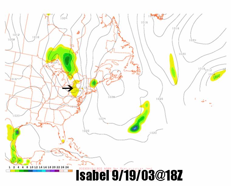
8 Figure 14: NARR 3-hourly accumulated precipitation Figure 15: NARR 3-hourly accumulated precipitation (shaded); Sea Level Pressure (contoured) (shaded); Sea Level Pressure (contoured) Figure 16: NARR 3-hourly accumulated precipitation Figure 17: NARR 3-hourly accumulated precipitation (shaded); Sea Level Pressure (contoured) (shaded); Sea Level Pressure (contoured) 8
Shawn M. Milrad Atmospheric Science Program Department of Geography University of Kansas Lawrence, Kansas
 Shawn M. Milrad Atmospheric Science Program Department of Geography University of Kansas Lawrence, Kansas Eyad H. Atallah and John R. Gyakum Department of Atmospheric and Oceanic Sciences McGill University
SEASONAL ENVIRONMENTAL CONDITIONS RELATED TO HURRICANE ACTIVITY IN THE NORTHEAST PACIFIC BASIN
 SEASONAL ENVIRONMENTAL CONDITIONS RELATED TO HURRICANE ACTIVITY IN THE NORTHEAST PACIFIC BASIN Jennifer M. Collins Department of Geography and Geosciences Bloomsburg University Bloomsburg, PA 17815 jcollins@bloomu.edu
Northern hemisphere storm tracks in strong AO anomaly winters
 ATMOSPHERIC SCIENCE LETTERS Atmos. Sci. Let. (2008) Published online in Wiley InterScience (www.interscience.wiley.com).186 Northern hemisphere storm tracks in strong AO anomaly winters Ji Nie,* Peng Wang,
Lower-Tropospheric Height Tendencies Associated with the Shearwise and Transverse Components of Quasigeostrophic Vertical Motion
 JULY 2007 N O T E S A N D C O R R E S P O N D E N C E 2803 Lower-Tropospheric Height Tendencies Associated with the Shearwise and Transverse Components of Quasigeostrophic Vertical Motion JONATHAN E. MARTIN
1. INTRODUCTION: 2. DATA AND METHODOLOGY:
 27th Conference on Hurricanes and Tropical Meteorology, 24-28 April 2006, Monterey, CA 3A.4 SUPERTYPHOON DALE (1996): A REMARKABLE STORM FROM BIRTH THROUGH EXTRATROPICAL TRANSITION TO EXPLOSIVE REINTENSIFICATION
10B.2 THE ROLE OF THE OCCLUSION PROCESS IN THE EXTRATROPICAL-TO-TROPICAL TRANSITION OF ATLANTIC HURRICANE KAREN
 10B.2 THE ROLE OF THE OCCLUSION PROCESS IN THE EXTRATROPICAL-TO-TROPICAL TRANSITION OF ATLANTIC HURRICANE KAREN Andrew L. Hulme* and Jonathan E. Martin University of Wisconsin-Madison, Madison, Wisconsin
THE EXTRATROPICAL TRANSITION OF TYPHOON WINNIE (1997): SELF-AMPLIFICATION AFTER LANDFALL
: SELF-AMPLIFICATION AFTER LANDFALL") THE EXTRATROPICAL TRANSITION OF TYPHOON WINNIE (1997): SELF-AMPLIFICATION AFTER LANDFALL Chih-Shin Liu *1,2 and George Tai-Jen Chen 2 1 Weather Forecast Center, Central Weather Bureau, 2 Department of
THE EXTRATROPICAL TRANSITION OF TYPHOON WINNIE (1997): SELF-AMPLIFICATION AFTER LANDFALL Chih-Shin Liu *1,2 and George Tai-Jen Chen 2 1 Weather Forecast Center, Central Weather Bureau, 2 Department of
Synoptic Meteorology II: Self-Development in the IPV Framework. 5-7 May 2015
 Synoptic Meteorology II: Self-Development in the IPV Framework 5-7 May 2015 Readings: Section 5.3.6 of Midlatitude Synoptic Meteorology. Introduction In this and other recent lectures, we have developed
Multiscale Analyses of Inland Tropical Cyclone Midlatitude Jet Interactions: Camille (1969) and Danny (1997)
 and Danny (1997)") Multiscale Analyses of Inland Tropical Cyclone Midlatitude Jet Interactions: Camille (1969) and Danny (1997) Matthew Potter, Lance Bosart, and Daniel Keyser Department of Atmospheric and Environmental
Multiscale Analyses of Inland Tropical Cyclone Midlatitude Jet Interactions: Camille (1969) and Danny (1997) Matthew Potter, Lance Bosart, and Daniel Keyser Department of Atmospheric and Environmental
Subtropical and Hybrid Systems IWTC VII Topic 1.6
 Subtropical and Hybrid Systems IWTC VII Topic 1.6 John R. Gyakum Department of Atmospheric and Oceanic Sciences McGill University, Montreal Canada Working group: John L. Beven II, Lance F. Bosart, Fermin
5A.3 THE USE OF ENSEMBLE AND ANOMALY DATA TO ANTICIPATE EXTREME FLOOD EVENTS IN THE NORTHEASTERN U.S.
 5A.3 THE USE OF ENSEMBLE AND ANOMALY DATA TO ANTICIPATE EXTREME FLOOD EVENTS IN THE NORTHEASTERN U.S. Neil A. Stuart(1), Richard H. Grumm(2), John Cannon(3), and Walt Drag(4) (1)NOAA/National Weather Service,
Chapter 5. Summary and Conclusions
 Chapter 5. Summary and Conclusions Two cases of heavy rainfall were analyzed using observational data sets and model simulations. The first case was the landfall of Hurricane Floyd in North Carolina in
Final Examination, MEA 443 Fall 2008, Lackmann
 Place an X here to count it double! Name: Final Examination, MEA 443 Fall 2008, Lackmann If you wish to have the final exam count double and replace your midterm score, place an X in the box above. As
Tropical-Extratropical Transition
 Tropical-Extratropical Transition Extratropical Transition A significant number of tropical cyclones move into the midlatitudes and transform into extratropical cyclones. This process is generally referred
3A.6 HURRICANES IVAN, JEANNE, KARL (2004) AND MID-LATITUDE TROUGH INTERACTIONS
 AND MID-LATITUDE TROUGH INTERACTIONS") 27 th Conference on Hurricanes and Tropical Meteorology 24-28 April 2006, Monterey, CA 3A.6 HURRICANES IVAN, JEANNE, KARL (2004) AND MID-LATITUDE TROUGH INTERACTIONS Ryan N. Maue *, Melinda S. Peng, Carolyn
27 th Conference on Hurricanes and Tropical Meteorology 24-28 April 2006, Monterey, CA 3A.6 HURRICANES IVAN, JEANNE, KARL (2004) AND MID-LATITUDE TROUGH INTERACTIONS Ryan N. Maue *, Melinda S. Peng, Carolyn
Synoptic Meteorology II: Petterssen-Sutcliffe Development Theory Application March 2015
 Synoptic Meteorology II: Petterssen-Sutcliffe Development Theory Application 10-12 March 2015 In our lecture on Petterssen-Sutcliffe Development Theory, we outlined the principle of selfdevelopment in
Precipitation Distribution Associated with Landfalling Tropical Cyclones over the Eastern United States
 JUNE 2007 A T A L L A H E T A L. 2185 Precipitation Distribution Associated with Landfalling Tropical Cyclones over the Eastern United States EYAD ATALLAH Department of Atmospheric and Oceanic Sciences,
1. Introduction. 3. Climatology of Genesis Potential Index. Figure 1: Genesis potential index climatology annual
 C. ENSO AND GENESIS POTENTIAL INDEX IN REANALYSIS AND AGCMS Suzana J. Camargo, Kerry A. Emanuel, and Adam H. Sobel International Research Institute for Climate and Society, Columbia Earth Institute, Palisades,
Joshua M. Boustead *1, and Barbara E. Mayes NOAA/NWS WFO Omaha/Valley, NE. William Gargan, George Phillips, and Jared Leighton NOAA/NWS WFO Topeka, KS
 7B.3 Composite Analysis of Environmental Conditions Favorable for Significant Tornadoes across Eastern Kansas Joshua M. Boustead *1, and Barbara E. Mayes NOAA/NWS WFO Omaha/Valley, NE William Gargan, George
Lec 10: Interpreting Weather Maps
 Lec 10: Interpreting Weather Maps Case Study: October 2011 Nor easter FIU MET 3502 Synoptic Hurricane Forecasts Genesis: on large scale weather maps or satellite images, look for tropical waves (Africa
THE IMPACT OF SATELLITE-DERIVED WINDS ON GFDL HURRICANE MODEL FORECASTS
 THE IMPACT OF SATELLITE-DERIVED WINDS ON GFDL HURRICANE MODEL FORECASTS Brian J. Soden 1 and Christopher S. Velden 2 1) Geophysical Fluid Dynamics Laboratory National Oceanic and Atmospheric Administration
2D.1 DETERMINATION OF A CONSISTENT TIME FOR THE EXTRATROPICAL TRANSITION OF TROPICAL CYCLONES
 2D.1 DETERMINATION OF A CONSISTENT TIME FOR THE EXTRATROPICAL TRANSITION OF TROPICAL CYCLONES David E. Kofron*, Elizabeth A. Ritchie, and J. Scott Tyo University of Arizona, Tucson, Arizona 1. INTRODUCTION
John Gyakum, Ron McTaggart-Cowan, Eyad Atallah, and Lance Bosart
 Hurricane Juan (2003): Forecasting and numerical simulation John Gyakum, Ron McTaggart-Cowan, Eyad Atallah, and Lance Bosart Outline Case Background Operational Forecasts and NWP Improved NWP Guidance
Chapter 24. Tropical Cyclones. Tropical Cyclone Classification 4/19/17
 Chapter 24 Tropical Cyclones Tropical Cyclones Most destructive storms on the planet Originate over tropical waters, but their paths often take them over land and into midlatitudes Names Hurricane (Atlantic
Synoptic Meteorology
 M.Sc. in Meteorology Synoptic Meteorology [MAPH P312] Prof Peter Lynch Second Semester, 2004 2005 Seminar Room Dept. of Maths. Physics, UCD, Belfield. Part 9 Extratropical Weather Systems These lectures
Quasi-Geostrophic Implications
 Chapter 10 Quasi-Geostrophic Implications When you look at a weather chart with all its isolines and plotted data, you need a framework upon which to interpret what you see. Quasi-geostrophic theory provides
Mid-Latitude Cyclones and Fronts. Lecture 12 AOS 101
 Mid-Latitude Cyclones and Fronts Lecture 12 AOS 101 Homework 4 COLDEST TEMPS GEOSTROPHIC BALANCE Homework 4 FASTEST WINDS L Consider an air parcel rising through the atmosphere The parcel expands as it
Early May Cut-off low and Mid-Atlantic rains
 Abstract: Early May Cut-off low and Mid-Atlantic rains By Richard H. Grumm National Weather Service State College, PA A deep 500 hpa cutoff developed in the southern Plains on 3 May 2013. It produced a
National Weather Service-Pennsylvania State University Weather Events
 National Weather Service-Pennsylvania State University Weather Events Heavy rainfall of 23 November 2011 by Richard H. Grumm National Weather Service State College PA 16803 Abstract:. A fast moving mid-tropospheric
TOWARDS A BETTER UNDERSTANDING OF AND ABILITY TO FORECAST THE WIND FIELD EXPANSION DURING THE EXTRATROPICAL TRANSITION PROCESS
 P1.17 TOWARDS A BETTER UNDERSTANDING OF AND ABILITY TO FORECAST THE WIND FIELD EXPANSION DURING THE EXTRATROPICAL TRANSITION PROCESS Clark Evans* and Robert E. Hart Florida State University Department
The Impact of the Extratropical Transition of Typhoon Dale (1996) on the Early Wintertime Stratospheric Circulation
 on the Early Wintertime Stratospheric Circulation") The Impact of the Extratropical Transition of Typhoon Dale (1996) on the Early 1996-97 Wintertime Stratospheric Circulation Andrea L. Lang 1, Jason M. Cordeira 2, Lance F. Bosart 1 and Daniel Keyser 1
The Impact of the Extratropical Transition of Typhoon Dale (1996) on the Early 1996-97 Wintertime Stratospheric Circulation Andrea L. Lang 1, Jason M. Cordeira 2, Lance F. Bosart 1 and Daniel Keyser 1
Tropical Cyclone Formation/Structure/Motion Studies
 Tropical Cyclone Formation/Structure/Motion Studies Patrick A. Harr Department of Meteorology Naval Postgraduate School Monterey, CA 93943-5114 phone: (831) 656-3787 fax: (831) 656-3061 email: paharr@nps.edu
(April 7, 2010, Wednesday) Tropical Storms & Hurricanes Part 2
 Tropical Storms & Hurricanes Part 2") Lecture #17 (April 7, 2010, Wednesday) Tropical Storms & Hurricanes Part 2 Hurricane Katrina August 2005 All tropical cyclone tracks (1945-2006). Hurricane Formation While moving westward, tropical disturbances
Lecture #17 (April 7, 2010, Wednesday) Tropical Storms & Hurricanes Part 2 Hurricane Katrina August 2005 All tropical cyclone tracks (1945-2006). Hurricane Formation While moving westward, tropical disturbances
A 40-year climatology of extratropical transition in the eastern North Pacific continued (and some other stuff)
") GOES-EAST image of Hurricane Dora, 1445 UTC 21 July 2011 A 40-year climatology of extratropical transition in the eastern North Pacific continued (and some other stuff) Elizabeth A. Ritchie and Kimberly
GOES-EAST image of Hurricane Dora, 1445 UTC 21 July 2011 A 40-year climatology of extratropical transition in the eastern North Pacific continued (and some other stuff) Elizabeth A. Ritchie and Kimberly
Estimating the intermonth covariance between rainfall and the atmospheric circulation
 ANZIAM J. 52 (CTAC2010) pp.c190 C205, 2011 C190 Estimating the intermonth covariance between rainfall and the atmospheric circulation C. S. Frederiksen 1 X. Zheng 2 S. Grainger 3 (Received 27 January 2011;
The Arctic Ocean's response to the NAM
 The Arctic Ocean's response to the NAM Gerd Krahmann and Martin Visbeck Lamont-Doherty Earth Observatory of Columbia University RT 9W, Palisades, NY 10964, USA Abstract The sea ice response of the Arctic
Modulation of Eastern North Pacific Hurricanes by the Madden-Julian Oscillation
 Modulation of Eastern North Pacific Hurricanes by the Madden-Julian Oscillation Eric D. Maloney* and Dennis L. Hartmann Department of Atmospheric Sciences University of Washington Seattle, Washington 98195-1640
13.3 CHARACTERIZATION OF EXTRATROPICAL TRANSITION USING CLUSTER ANALYSIS
 13.3 CHARACTERIZATION OF EXTRATROPICA TRANSITION USING CUSTER ANAYSIS Justin M. Arnott* and Jenni. Evans The Pennsylvania State University, Department of Meteorology, University Park, Pennsylvania 1. INTRODUCTION
P1.14 THE SPATIAL PATTERNS OF RAINFALL PRODUCED BY HURRICANE IRENE (2011) AND OTHER TROPICAL CYCLONES WITH SIMILAR TRACKS
 AND OTHER TROPICAL CYCLONES WITH SIMILAR TRACKS") P1.14 THE SPATIAL PATTERNS OF RAINFALL PRODUCED BY HURRICANE IRENE (2011) AND OTHER TROPICAL CYCLONES WITH SIMILAR TRACKS Corene J. Matyas * University of Florida, Gainesville, Florida 1. INTRODUCTION
P1.14 THE SPATIAL PATTERNS OF RAINFALL PRODUCED BY HURRICANE IRENE (2011) AND OTHER TROPICAL CYCLONES WITH SIMILAR TRACKS Corene J. Matyas * University of Florida, Gainesville, Florida 1. INTRODUCTION
Cyclolysis: A Diagnosis of Two Extratropical Cyclones
 2714 MONTHLY WEATHER REVIEW VOLUME 129 Cyclolysis: A Diagnosis of Two Extratropical Cyclones WILLIAM E. MORRIS JR.* AND PHILLIP J. SMITH Department of Earth and Atmospheric Sciences, Purdue University
5D.6 EASTERLY WAVE STRUCTURAL EVOLUTION OVER WEST AFRICA AND THE EAST ATLANTIC 1. INTRODUCTION 2. COMPOSITE GENERATION
 5D.6 EASTERLY WAVE STRUCTURAL EVOLUTION OVER WEST AFRICA AND THE EAST ATLANTIC Matthew A. Janiga* University at Albany, Albany, NY 1. INTRODUCTION African easterly waves (AEWs) are synoptic-scale disturbances
The Impact of air-sea interaction on the extratropical transition of tropical cyclones
 The Impact of air-sea interaction on the extratropical transition of tropical cyclones Sarah Jones Institut für Meteorologie und Klimaforschung Universität Karlsruhe / Forschungszentrum Karlsruhe 1. Introduction
Extratropical transition of North Atlantic tropical cyclones in variable-resolution CAM5
 Extratropical transition of North Atlantic tropical cyclones in variable-resolution CAM5 Diana Thatcher, Christiane Jablonowski University of Michigan Colin Zarzycki National Center for Atmospheric Research
P2.4 THE IMPACT OF TROPICAL CYCLONE REMNANTS ON THE RAINFALL OF THE NORTH AMERICAN SOUTHWEST REGION
 P2.4 THE IMPACT OF TROPICAL CYCLONE REMNANTS ON THE RAINFALL OF THE NORTH AMERICAN SOUTHWEST REGION by Elizabeth A. Ritchie 1 and David Szenasi University of New Mexico 1. INTRODUCTION New Mexico has a
Examples of Pressure Gradient. Pressure Gradient Force. Chapter 7: Forces and Force Balances. Forces that Affect Atmospheric Motion 2/2/2015
 Chapter 7: Forces and Force Balances Forces that Affect Atmospheric Motion Fundamental force - Apparent force - Pressure gradient force Gravitational force Frictional force Centrifugal force Forces that
ATM OCN 452. The Frontal Cyclone. Fall 2013
 ATM OCN 452 The Frontal Cyclone Fall 2013 Instructor: Dr. Jonathan E. Martin 1425A Meteorology and Space Science jemarti1@wisc.edu 262-9845 Office Hours: Wed. 12:30 2:25 (or by appointment) T. A.: Andrew
The Interdecadal Variation of the Western Pacific Subtropical High as Measured by 500 hpa Eddy Geopotential Height
 ATMOSPHERIC AND OCEANIC SCIENCE LETTERS, 2015, VOL. 8, NO. 6, 371 375 The Interdecadal Variation of the Western Pacific Subtropical High as Measured by 500 hpa Eddy Geopotential Height HUANG Yan-Yan and
Description of the ET of Super Typhoon Choi-Wan (2009) based on the YOTC-dataset
 based on the YOTC-dataset") High Impact Weather PANDOWAE Description of the ET of Super Typhoon Choi-Wan (2009) based on the YOTC-dataset ¹, D. Anwender¹, S. C. Jones2, J. Keller2, L. Scheck¹ 2 ¹Karlsruhe Institute of Technology,
High Impact Weather PANDOWAE Description of the ET of Super Typhoon Choi-Wan (2009) based on the YOTC-dataset ¹, D. Anwender¹, S. C. Jones2, J. Keller2, L. Scheck¹ 2 ¹Karlsruhe Institute of Technology,
Predecessor Rain Events: A Literature Review. By: Tony Viramontez
 Predecessor Rain Events: A Literature Review By: Tony Viramontez Introduction Predecessor Rain Event (PRE): meso- and subsynopticscale regions of high-impact heavy rainfall that occur well in advance of
Interaction of Potential Vorticity Anomalies in Extratropical Cyclogenesis. Part I: Static Piecewise Inversion
 2546 MONTHLY WEATHER REVIEW VOLUME 127 Interaction of Potential Vorticity Anomalies in Extratropical Cyclogenesis. Part I: Static Piecewise Inversion ZONGHUI HUO CMRP, School of Meteorology, University
SHORT COMMUNICATION INTERANNUAL VARIATIONS OF STORM TRACKS IN THE SOUTHERN HEMISPHERE AND THEIR CONNECTIONS WITH THE ANTARCTIC OSCILLATION
 INTERNATIONAL JOURNAL OF CLIMATOLOGY Int. J. Climatol. 23: 1537 1545 (2003) Published online in Wiley InterScience (www.interscience.wiley.com). DOI: 10.1002/joc.948 SHORT COMMUNICATION INTERANNUAL VARIATIONS
3. Midlatitude Storm Tracks and the North Atlantic Oscillation
 3. Midlatitude Storm Tracks and the North Atlantic Oscillation Copyright 2006 Emily Shuckburgh, University of Cambridge. Not to be quoted or reproduced without permission. EFS 3/1 Review of key results
CHAPTER 13 WEATHER ANALYSIS AND FORECASTING MULTIPLE CHOICE QUESTIONS
 CHAPTER 13 WEATHER ANALYSIS AND FORECASTING MULTIPLE CHOICE QUESTIONS 1. The atmosphere is a continuous fluid that envelops the globe, so that weather observation, analysis, and forecasting require international
Conference on Teleconnections in the Atmosphere and Oceans November 2008
 1968-38 Conference on Teleconnections in the Atmosphere and Oceans 17-20 November 2008 Mid-latitude - MJO teleconnection over East Asia in the Northern winter KIM Baekmin Yonsei University Dept. of Atmospheric
General Circulation. Nili Harnik DEES, Lamont-Doherty Earth Observatory
 General Circulation Nili Harnik DEES, Lamont-Doherty Earth Observatory nili@ldeo.columbia.edu Latitudinal Radiation Imbalance The annual mean, averaged around latitude circles, of the balance between the
Simulations of the Extratropical Transition of Tropical Cyclones: Contributions by the Midlatitude Upper-Level Trough to Reintensification
 2112 MONTHLY WEATHER REVIEW Simulations of the Extratropical Transition of Tropical Cyclones: Contributions by the Midlatitude Upper-Level Trough to Reintensification ELIZABETH A. RITCHIE Department of
Variations of total heat flux during typhoons in the South China Sea
 78 Variations of total heat flux during typhoons in the South China Sea Wan Ruslan Ismail 1, and Tahereh Haghroosta 2,* 1 Section of Geography, School of Humanities, Universiti Sains Malaysia, 11800 Minden,
Vertical structure. To conclude, we will review the critical factors invloved in the development of extratropical storms.
 Vertical structure Now we will examine the vertical structure of the intense baroclinic wave using three visualization tools: Upper level charts at selected pressure levels Vertical soundings for selected
Snow water equivalent variability and forecast in Lithuania
 BOREAL ENVIRONMENT RESEARCH 7: 457 462 ISSN 1239-6095 Helsinki 23 December 2002 2002 Snow water equivalent variability and forecast in Lithuania Egidijus Rimkus and Gintautas Stankunavichius Department
Investigating Daily Summertime Circulation and Precipitation Over West Africa with the WRF Model: A Regional Climate Model Adaptation Study
 University of Colorado, Boulder CU Scholar Environmental Studies Graduate Theses & Dissertations Environmental Studies Spring 1-1-2014 Investigating Daily Summertime Circulation and Precipitation Over
Response of Baroclinic Life Cycles to Barotropic Shear
 VOL. 55, NO. 3 JOURNAL OF THE ATMOSPHERIC SCIENCES 1FEBRUARY 1998 Response of Baroclinic Life Cycles to Barotropic Shear DENNIS L. HARTMANN AND PETER ZUERCHER Department of Atmospheric Sciences, University
Tropical Storm Hermine: Heavy rainfall in western Gulf By Richard H. Grumm National Weather Service Office State College, PA 16803
 Tropical Storm Hermine: Heavy rainfall in western Gulf By Richard H. Grumm National Weather Service Office State College, PA 16803 1. INTRODUCTION Tropical storm Hermine, the eighth named tropical system
Evaluation of Extreme Severe Weather Environments in CCSM3
 Evaluation of Extreme Severe Weather Environments in CCSM3 N. McLean, C. Radermacher, E. Robinson, R. Towe, Y. Tung June 24, 2011 The ability of climate models to predict extremes is determined by its
Shawn M. Milrad and John R. Gyakum Department of Atmospheric and Oceanic Sciences McGill University Montreal, QC, Canada
 Shawn M. Milrad and John R. Gyakum Department of Atmospheric and Oceanic Sciences McGill University Montreal, QC, Canada Motivation Outline 6-8 December 2010 surprise snow Meteorological Issues Case overview
AN EXTRATROPICAL CYCLONE ATLAS
 AN EXTRATROPICAL CYCLONE ATLAS A tool for illustrating cyclone structure and evolution characteristics BY H. F. DACRE, M. K. HAWCROFT, M. A. STRINGER AND K. I. HODGES Authors Affiliations H.F.Dacre, Department
Divergence, Spin, and Tilt. Convergence and Divergence. Midlatitude Cyclones. Large-Scale Setting
 Midlatitude Cyclones Equator-to-pole temperature gradient tilts pressure surfaces and produces westerly jets in midlatitudes Waves in the jet induce divergence and convergence aloft, leading to surface
A Preliminary Climatology of Extratropical Transitions in the Southwest Indian Ocean
 A Preliminary Climatology of Extratropical Transitions in the Southwest Indian Ocean Kyle S. Griffin Department of Atmospheric and Environmental Sciences, University at Albany, State University of New
EXAMINING PLANETARY, SYNOPTIC, AND MESOSCALE FEATURES THAT ENHANCE PRECIPITATION ASSOCIATED WITH TROPICAL CYCLONES MAKING LANDFALL OVER NORTH CAROLINA
 EXAMINING PLANETARY, SYNOPTIC, AND MESOSCALE FEATURES THAT ENHANCE PRECIPITATION ASSOCIATED WITH TROPICAL CYCLONES MAKING LANDFALL OVER NORTH CAROLINA Meredith S. Croke*, Michael L. Kaplan and Lian Xie
Fronts in November 1998 Storm
 Fronts in November 1998 Storm Much of the significant weather observed in association with extratropical storms tends to be concentrated within narrow bands called frontal zones. Fronts in November 1998
COMPOSITE MEANS AND ANOMALIES OF METEOROLOGICAL PARAMETERS FOR SUMMERTIME FLASH FLOODING IN THE NATIONAL WEATHER SERVICE EASTERN REGION
 COMPOSITE MEANS AND ANOLIES OF METEOROLOGICAL PARAMETERS FOR SUMMERTIME FLASH FLOODING IN THE NATIONAL WEATHER SERVICE EASTERN REGION Alan M. Cope and Lee Robertson NOAA/National Weather Service Mount
Dynamics of the Atmosphere. Large-scale flow with rotation and stratification
 12.810 Dynamics of the Atmosphere Large-scale flow with rotation and stratification Visualization of meandering jet stream Upper level winds from June 10th to July 8th 1988 from MERRA Red shows faster
Scenarios in the development of Mediterranean cyclones
 Author(s) 2007. This work is licensed under a Creative Commons License. Advances in Geosciences Scenarios in the development of Mediterranean cyclones M. Romem 1, B. Ziv 2, and H. Saaroni 1 1 Department
11B.1 INFLUENCE OF DIABATIC POTENTIAL VORTICITY ANOMALIES UPON WARM CONVEYOR BELT FLOW. PART I: FEBRUARY 2003
 INFLUENCE OF DIABATIC POTENTIAL VORTICITY ANOMALIES UPON WARM CONVEYOR BELT FLOW. PART I: 14-15 FEBRUARY 2003 Philip N. Schumacher, NOAA/NWS, Sioux Falls, SD Joshua M. Boustead, NOAA/NWS, Valley, NE Martin
Meteorology Lecture 15
 Meteorology Lecture 15 Robert Fovell rfovell@albany.edu 1 Important notes These slides show some figures and videos prepared by Robert G. Fovell (RGF) for his Meteorology course, published by The Great
16C.6 Genesis of Atlantic tropical storms from African Easterly Waves a comparison of two contrasting years
 16C.6 Genesis of Atlantic tropical storms from African Easterly Waves a comparison of two contrasting years Susanna Hopsch 1 Department of Earth and Atmospheric Sciences, University at Albany, Albany,
Diagnostic Study of a Severe Thunderstorm over Jeddah
 Atmospheric and Climate Sciences, 2013, 3, 150-164 http://dx.doi.org/10.4236/acs.2013.31017 Published Online January 2013 (http://www.scirp.org/journal/acs) Diagnostic Study of a Severe Thunderstorm over
Diabatic processes and the structure of extratropical cyclones
 Geophysical and Nonlinear Fluid Dynamics Seminar AOPP, Oxford, 23 October 2012 Diabatic processes and the structure of extratropical cyclones Oscar Martínez-Alvarado R. Plant, J. Chagnon, S. Gray, J. Methven
Unusual North Atlantic temperature dipole during the winter of 2006/2007
 Unusual North Atlantic temperature dipole during the winter of 2006/2007 4 J. J.-M. Hirschi National Oceanography Centre, Southampton, United Kingdom Over most of western Europe and generally over the
The increase of snowfall in Northeast China after the mid 1980s
 Article Atmospheric Science doi: 10.1007/s11434-012-5508-1 The increase of snowfall in Northeast China after the mid 1980s WANG HuiJun 1,2* & HE ShengPing 1,2,3 1 Nansen-Zhu International Research Center,
Characteristic blocking events over Ural-Siberia in Boreal Winter under Present and Future Climate Conditions
 Characteristic blocking events over Ural-Siberia in Boreal Winter under Present and Future Climate Conditions Wen Zhou & Hoffman Cheung Guy Carpenter Asia-Pacific Climate Impact Center School of Energy
PATRICK A. HARR. Department of Meteorology, Naval Postgraduate School, Monterey, California
 VOLUME 136 M O N T H L Y W E A T H E R R E V I E W SEPTEMBER 2008 Predictability Associated with the Downstream Impacts of the Extratropical Transition of Tropical Cyclones: Methodology and a Case Study
ADJONT-BASED ANALYSIS OF OBSERVATION IMPACT ON TROPICAL CYCLONE INTENSITY FORECASTS
 7A.3 ADJONT-BASED ANALYSIS OF OBSERVATION IMPACT ON TROPICAL CYCLONE INTENSITY FORECASTS Brett T. Hoover* and Chris S. Velden Cooperative Institute for Meteorological Satellite Studies, Space Science and
HOW WELL DOES THE GROWING SEASON INDEX CORRESPOND TO THE START OF FIRE SEASON? San Antonio College, San Antonio, TX
 HOW WELL DOES THE GROWING SEASON INDEX CORRESPOND TO THE START OF FIRE SEASON? Matthew Anaya 1, Brian Potter 2* and Narasimhan Larkin 2 1 San Antonio College, San Antonio, TX 2 AirFire Team, USDA Forest
2015 Hurricane Season Summary for Eastern Canada Impacts and Operational Notes
 2015 Hurricane Season Summary for Eastern Canada Impacts and Operational Notes John Parker Canadian Hurricane Centre, Meteorological Service of Canada April, 2016 Storms affecting Canadian territory in
4/29/2011. Mid-latitude cyclones form along a
 Chapter 10: Cyclones: East of the Rocky Mountain Extratropical Cyclones Environment prior to the development of the Cyclone Initial Development of the Extratropical Cyclone Early Weather Along the Fronts
and 24 mm, hPa lapse rates between 3 and 4 K km 1, lifted index values
 3.2 Composite analysis 3.2.1 Pure gradient composites The composite initial NE report in the pure gradient northwest composite (N = 32) occurs where the mean sea level pressure (MSLP) gradient is strongest
True or false: The atmosphere is always in hydrostatic balance. A. True B. False
 Clicker Questions and Clicker Quizzes Clicker Questions Chapter 7 Of the four forces that affect the motion of air in our atmosphere, which is to thank for opposing the vertical pressure gradient force
Synoptic Meteorology II: Frontogenesis Examples Figure 1
 Synoptic Meteorology II: Frontogenesis Examples The below images, taken from the 1200 UTC 17 January 2019 GFS forecast run, provide examples of the contributions of deformation and divergence to frontogenesis.
ESCI 344 Tropical Meteorology Lesson 11 Tropical Cyclones: Formation, Maintenance, and Intensification
 ESCI 344 Tropical Meteorology Lesson 11 Tropical Cyclones: Formation, Maintenance, and Intensification References: A Global View of Tropical Cyclones, Elsberry (ed.) Global Perspectives on Tropical Cylones:
The dynamics of high and low pressure systems
 The dynamics of high and low pressure systems Newton s second law for a parcel of air in an inertial coordinate system (a coordinate system in which the coordinate axes do not change direction and are
The purpose of this thesis is to present two multiscale analyses of inland tropical
 I. Introduction 1.1 General Purpose The purpose of this thesis is to present two multiscale analyses of inland tropical cyclone (TC) midlatitude jet interactions. More specifically, the main focus will
Variability of the surface circulation of the Nordic Seas during the 1990s
 ICES Marine Science Symposia 219: 367-370. Variability of the surface circulation of the Nordic Seas during the 1990s Philip K. Jakobsen, Mads H. Ribergaard, Detlef Quadfasel, and Torben Schmith The surface
PRECIPITATION FROM VERTICAL MOTION: A STATISTICAL DIAGNOSTIC SCHEME
 INTERNATIONAL JOURNAL OF CLIMATOLOGY Int. J. Climatol. 23: 903 919 (2003) Published online in Wiley InterScience (www.interscience.wiley.com). DOI: 10.1002/joc.919 PRECIPITATION FROM VERTICAL MOTION: A
Comparison of Wave Packets associated with Extratropical. Transition and Winter Cyclones. Ryan D. Torn. Gregory J. Hakim
 Generated using version 3.1.2 of the official AMS L A TEX template 1 Comparison of Wave Packets associated with Extratropical 2 Transition and Winter Cyclones 3 Ryan D. Torn Department of Atmospheric and
Mélicie Desflots* RSMAS, University of Miami, Miami, Florida
 15B.6 RAPID INTENSITY CHANGE IN HURRICANE LILI (2002) Mélicie Desflots* RSMAS, University of Miami, Miami, Florida 1. INTRODUCTION Rapid intensity change in tropical cyclones is one of the most difficult
The feature of atmospheric circulation in the extremely warm winter 2006/2007
 The feature of atmospheric circulation in the extremely warm winter 2006/2007 Hiroshi Hasegawa 1, Yayoi Harada 1, Hiroshi Nakamigawa 1, Atsushi Goto 1 1 Climate Prediction Division, Japan Meteorological
The downstream impact of tropical cyclones on a developing baroclinic wave in idealized scenarios of extratropical transition
 Quarterly Journal of the Royal Meteorological Society Q. J. R. Meteorol. Soc. 136: 617 637, April 2010 Part A The downstream impact of tropical cyclones on a developing baroclinic wave in idealized scenarios
Abstract. 1. Introduction
 ATMOSPHERIC SCIENCE LETTERS Atmos. Sci. Let. 17: 610 615 (2016) Published online in Wiley Online Library (wileyonlinelibrary.com) DOI: 10.1002/asl.710 The interannual relationship between anomalous precipitation
Maintenance of Circulation Anomalies during the 1988 Drought and 1993 Floods over the United States
 Department of Physical Sciences - Daytona Beach College of Arts & Sciences 9-1-1998 Maintenance of Circulation Anomalies during the 1988 Drought and 1993 Floods over the United States Alan Z. Liu Embry
Fixed Rossby Waves: Quasigeostrophic Explanations and Conservation of Potential Vorticity
 Fixed Rossby Waves: Quasigeostrophic Explanations and Conservation of Potential Vorticity 1. Observed Planetary Wave Patterns After upper air observations became routine, it became easy to produce contour