Predecessor Rain Events: A Literature Review. By: Tony Viramontez
|
|
|
- Daniela Parsons
- 5 years ago
- Views:
Transcription
1 Predecessor Rain Events: A Literature Review By: Tony Viramontez
2 Introduction Predecessor Rain Event (PRE): meso- and subsynopticscale regions of high-impact heavy rainfall that occur well in advance of recurving tropical cyclones (TCs)
3 Requirements Coherent region of rainfall rainfall > 100 mm (approx. 4 in) in 24 hr Typically, positioned 1000 km poleward and separate from TC initiates 36 hr prior to the arrival of the TC
4 Requirements Tropical Moisture Precipitable water values > 50 mm Associated with TC and advected poleward by TC Occurs where deep tropical moisture intersects region of forced ascent Beneath an equatorward jet- entrance region. Frontal or Orographic Shortwave
 PRE.")
5 Idealized Synoptic Scale environment of a left of TC track (LOT) PRE. (From Moore (2010))
6 Why do we care? Forecasting Challenges Models do not handle PRE s well Difficulty representing TC and mid-latitude interactions While focus is on TC, PRE s can catch forecasters by surprise Societal Impacts Flooding

.")
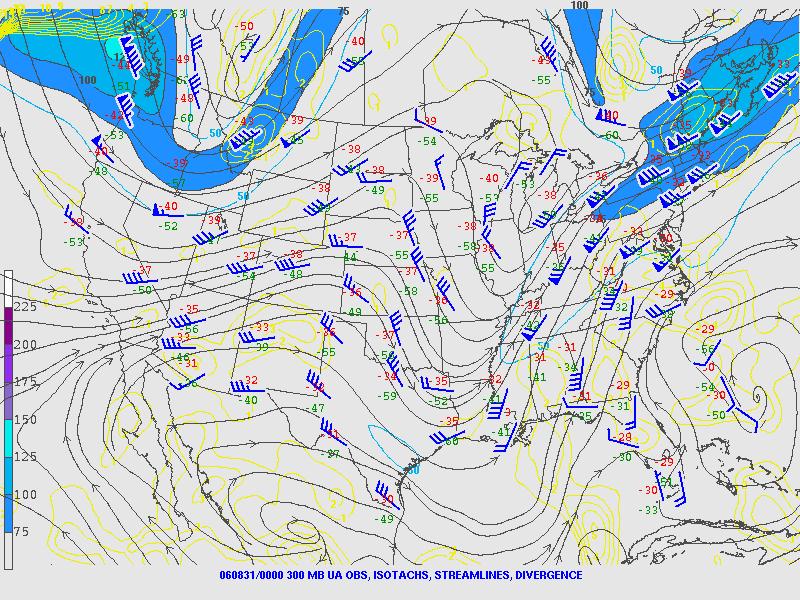
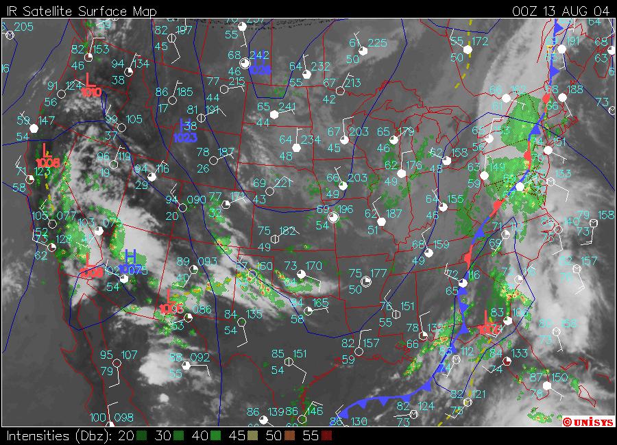
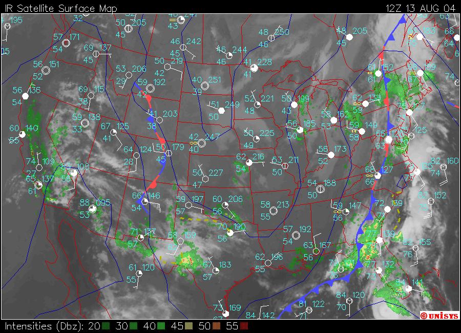
7 Societal Impacts Base reflectivity mosaic from 1200 UTC 8 Sep 2004 of TC Frances and a front page photo and article highlighting the flooding from the high-impact TC Frances PRE (2004, The New York Times). (From Galarneau 2010)
 produce a PRE")
8 Where? Eastern 1/3 of the U.S. Approximately 30% of all TCs that pass west of 70 W and north of 20 N (near Dominican Republic/Haiti) produce a PRE Southwestern U.S. Eastern Asia Satellite Imagery of Typhoon Songda (2004) from Wang et al
9 When? Histogram of the monthly frequency distribution of all TCs (gray bars) and TCs that produced PREs (black bars) during (From Moore 2010) Earliest documented PRE occurred in the Northeast U.S in 1938
, TCs that produced PREs (black bars), and")
10 How Intense is the Parent TC? Maximum TC intensity on the Saffir Simpson scale category for all TCs (gray bars), TCs that produced PREs (black bars), and the TC intensity at the time of PRE initiation (clear bars) during (From Moore 2010)
11 Categories Categories based on large scale synoptic flow pattern 1) Upper Level Jet Structure Upper-level ridge ( anticyclonically curved category) Upper-level trough ( cyclonically curved category) 2) Further classifications account for variations beyond simply trough or ridge Downstream Confluent Southwesterly Jet Jet in Ridge

12 Downstream Confluence An upper-level trough is situated downstream and poleward of the TC, and the jet streak is positioned in a region of confluence downstream of the TC. Geopotential height contours are shown in black, the jet streak is represented by the gray shaded region, and the location of maximum wind speed is denoted by the J symbol. PRE and TC locations are indicated by the + symbol and the tropical storm symbol, respectively. (From Moore 2012)
 at the time of PRE")
 Idealized synopticscale")
13 PRE initiation locations (green) from and the TC locations (red) at the time of PRE initiation. (From Moore 2012) Idealized synopticscale environment for southwesterly jet PRE s. (From Moore 2012)

14 Southwesterly Jet Features a southwesterly jet streak positioned downstream of an upper-level trough that is located immediately upstream and poleward of the TC. Same as before. (From Moore 2012)

15 Idealized synoptic-scale environment for southwesterly jet PRE s. (From Moore 2012)

 at the")
16 Same as above. Due to number of examples, the plots were split. (From Moore 2012) PRE initiation locations (green) from and the TC locations (red) at the time of PRE initiation. From Moore 2012)

17 Jet in Ridge Features an anticyclonically curved jet streak on the poleward flank of a broad upper-level ridge, with the TC beneath Occur exclusively in the Midwest Same as before. (From Moore 2012)
 at the time of PRE")
 Idealized synoptic-scale")
18 PRE initiation locations (green) from and the TC locations (red) at the time of PRE initiation. (From Moore 2012) Idealized synoptic-scale environment for jet in ridge PRE s. (From Moore 2012)
 the")

19 Total precipitation (mm) for Typhoon Songda between 1800 UTC 2 Sep and 0000 UTC 5 Sep 2004 in (a) the control experiment and (b) the No- Typhoon experiment run with the Advanced Research WRF model. (From Wang 2009)

20 Ernesto (2006) 8/24 9/04 Maximum Wind Speed: 75 mph Lowest Central Pressure: 985 mb Downstream confluent, anticyclonically curved jet (From Weather Underground)
21

22
23
24
25 Precipitable Water (PW) Precipitable water is a measure of the depth of liquid water at the surface that would result after precipitating all of the water vapor in a vertical column over a given location, usually extending from the surface to 300mb.
")
 Newport, North Carolina.")
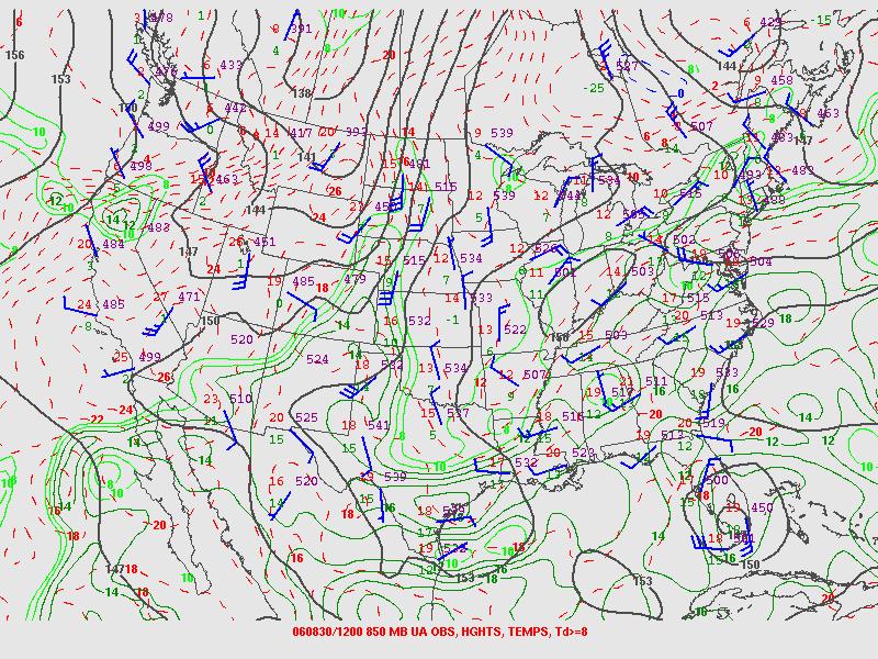
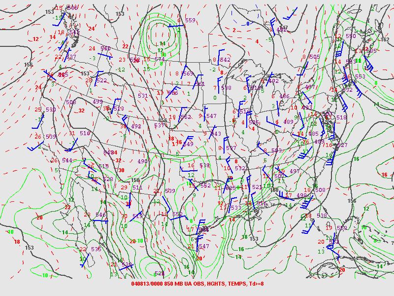
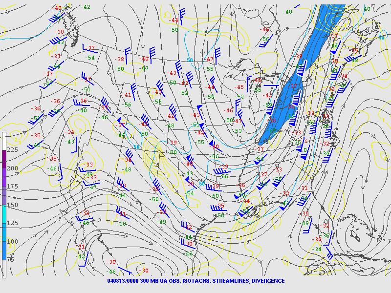
26 54 mm = 2.13 in 53 mm = 2.09 in Soundings for a) Greensboro, North Carolina and b) Newport, North Carolina. (From Moore 2010)

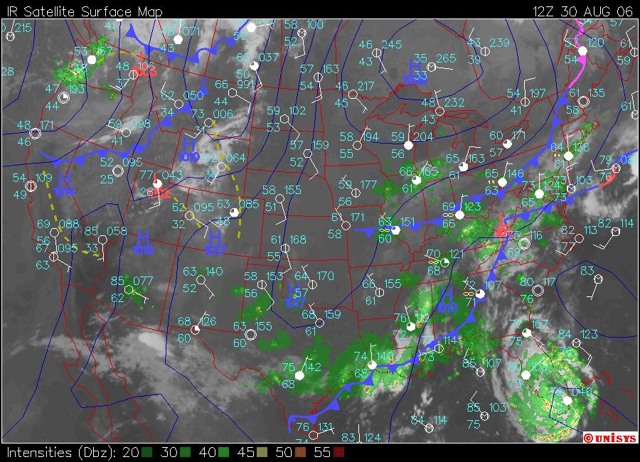
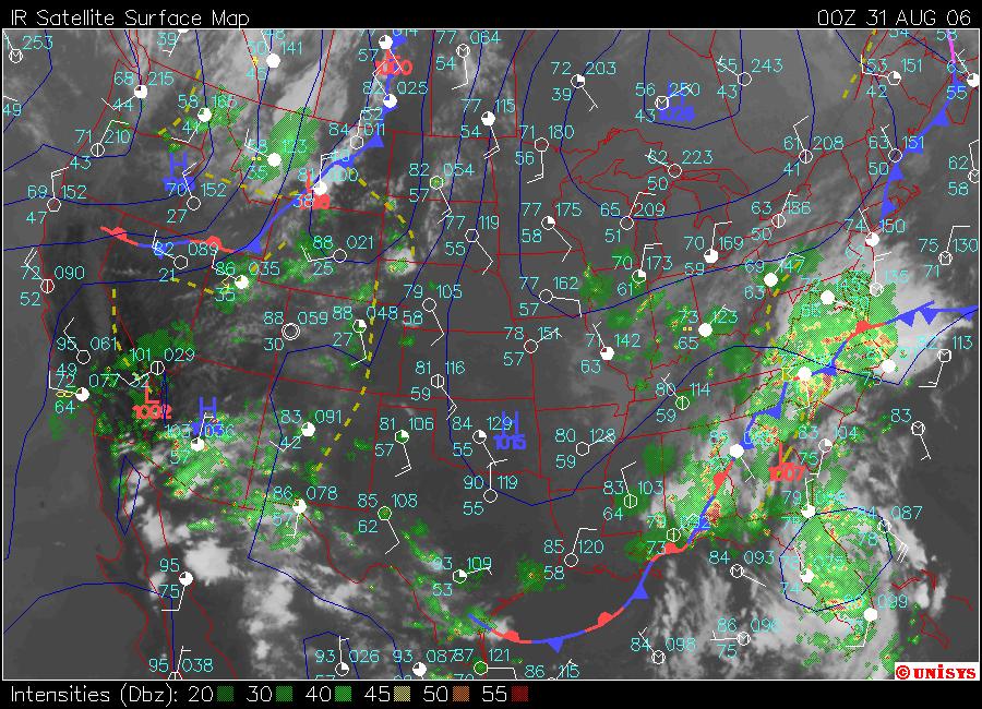
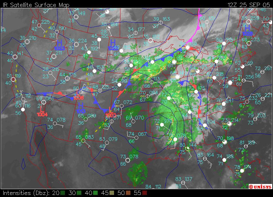
27 Precipitable Water Values for 1800 UTC 30 August (From Moore 2010)

28 2.09 in Newport, North Carolina Precipitable Water Climatology (from NWS)
29 Impact of TC Ernesto Maximum Rainfall Amount (including PRE and TC): at Wrightsville Beach, North Carolina Maximum Rainfall Amount from PRE: 9.85 at Grifton, North Carolina Flooding was the primary impact of Ernesto Costliest Storm of the 2006 Atlantic Hurricane Season (Cost = $500 million (US dollars)
30 Charley (2004) 8/09 8/15 Maximum Wind Speed: 145 mph Lowest Central Pressure: 947 mb Southwesterly jet, cyclonically curved jet (From Weather Underground)
31
32
33
34
35 Sounding for Jacksonville, Florida mm = 2.57 in

36 2.57 in Jacksonville, Florida Precipitable Water Climatology (From NWS)
37 Impacts of Charley Maximum Rainfall Amount from TC and PRE: 9.88 at Bud Slough, Florida. Cost: >$15 billion (US dollars)
38 TC Rita (2005) 9/18 9/26 Maximum Wind Speed: 180 mph Lowest Central Pressure: 897 mb One of the most intense Atlantic Hurricanes ever Jet in ridge, anticyclonically curved jet (From Weather Underground)
39 Surface

40
41
42
43
44
")

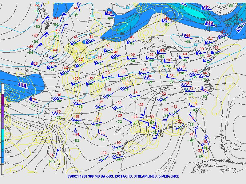
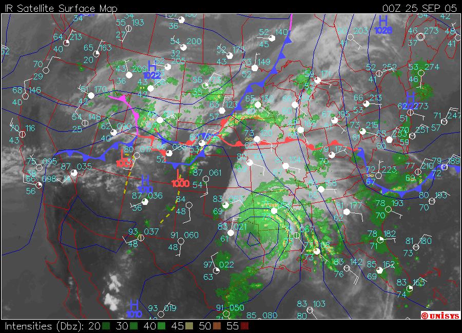
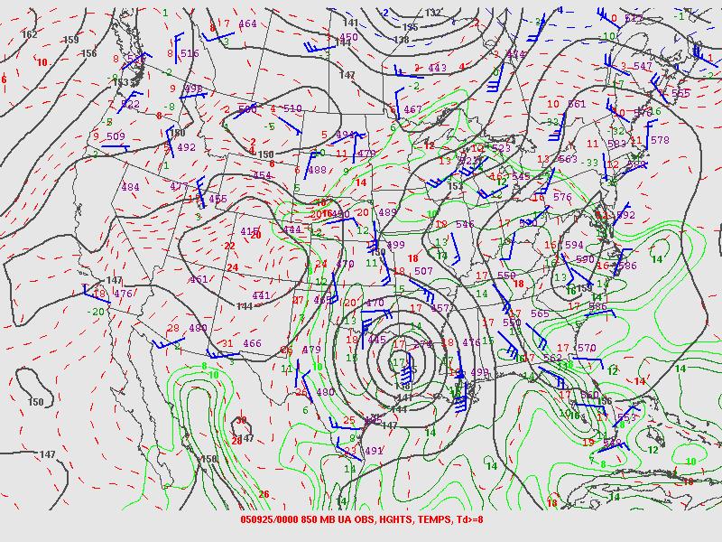
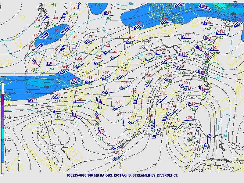
45 36 mm = 1.42 in 37 mm = 1.46 in Soundings for a) Omaha, Nebraska and b) Chanhassen, Minnesota. (From Moore 2010)

46 Precipitable Water Values for 0000 UTC 25 September (Moore 2010)

47 1.42 in Omaha, Nebraska Precipitable Water Climatology (From NWS)
48 Impact of Hurricane Rita Maximum Rainfall Amount from TC: at Bunkie, Louisiana Maximum Rainfall Amount from PRE: 7.8 Cost: >$12 billion (US dollars)
49 Summary Predecessor Rain Events (PREs) are a coherent region of heavy rainfall associated with deep tropical moisture advected poleward by a TC 3 Categories: Downstream confluence, southwesterly jet, and jet in ridge PREs have a large human impact potential through heavy rainfall and flooding.
50 References Bosart, L. F., J. M. Cordeira, T. J. Galarneau, B. J. Moore, H. M. Archambault, 2012: An analysis of multiple predecessor rain events ahead of tropical cyclones Ike and Lowell: September Mon. Wea. Rev., 140, Cote, M. R., 2007: Predecessor rain events in advance of tropical cyclones. M.S. thesis, Department of Atmospheric and Environmental Sciences, University at Albany, State University of New York, 200 pp. [Available online at Galarneau, T. J., L. F. Bosart, R. S. Schumacher, 2010: Predecessor rain events ahead of tropical cyclones. Mon. Wea. Rev., 138, Moore, B.J., 2010: Synoptic-scale environments and dynamical mechanisms associated with predecessor rain events ahead of tropical cyclones. Thesis, Department of Atmospheric and Environmental Sciences, University at Albany, 150. Moore, B. J., L. F. Bosart, D. Keyser, M. L. Jurewicz, 2013: Synoptic-scale environments of predecessor rain events occurring east of the rocky mountains in association with Atlantic basin tropical cyclones*. Mon. Wea. Rev., 141, Schumacher, R. S., T. J. Galarneau, L. F. Bosart, 2011: Distant effects of a recurving tropical cyclone on rainfall in a midlatitude convective system: A high-impact predecessor rain event*. Mon. Wea. Rev., 139, Schumacher, R. S., T. J. Galarneau, 2012: Moisture transport into midlatitudes ahead of recurving tropical cyclones and its relevance in two predecessor rain events. Mon. Wea. Rev., 140, Wang, Y., Y. Wang, and H. Fudeyasu, 2009: The role of Typhoon Songda (2004) in producing distantly located heavy rainfall in Japan. Mon. Wea. Rev., 137,

51
Benjamin J. Moore. Education. Professional experience
 Benjamin J. Moore Department of Atmospheric and Environmental Sciences University at Albany, State University of New York 1400 Washington Avenue Albany, New York, 12222 phone: +1 507 398 7427 email: bjmoore@albany.edu
Multiscale Analyses of Inland Tropical Cyclone Midlatitude Jet Interactions: Camille (1969) and Danny (1997)
 and Danny (1997)") Multiscale Analyses of Inland Tropical Cyclone Midlatitude Jet Interactions: Camille (1969) and Danny (1997) Matthew Potter, Lance Bosart, and Daniel Keyser Department of Atmospheric and Environmental
Multiscale Analyses of Inland Tropical Cyclone Midlatitude Jet Interactions: Camille (1969) and Danny (1997) Matthew Potter, Lance Bosart, and Daniel Keyser Department of Atmospheric and Environmental
Wet weeks in the warm season: Patterns and processes supporting widespread multi-day precipitation episodes!
 Wet weeks in the warm season: Patterns and processes supporting widespread multi-day precipitation episodes! Russ S. Schumacher and Samantha L. Lynch! Department of Atmospheric Science, Colorado State
Impacts of the April 2013 Mean trough over central North America
 Impacts of the April 2013 Mean trough over central North America By Richard H. Grumm National Weather Service State College, PA Abstract: The mean 500 hpa flow over North America featured a trough over
Lec 10: Interpreting Weather Maps
 Lec 10: Interpreting Weather Maps Case Study: October 2011 Nor easter FIU MET 3502 Synoptic Hurricane Forecasts Genesis: on large scale weather maps or satellite images, look for tropical waves (Africa
Chapter 24 Tropical Cyclones
 Chapter 24 Tropical Cyclones Tropical Weather Systems Tropical disturbance a cluster of thunderstorms about 250 to 600 km in diameter, originating in the tropics or sub-tropics Tropical depression a cluster
Summary of November Central U.S. Winter Storm By Christopher Hedge
 Summary of November 12-13 2010 Central U.S. Winter Storm By Christopher Hedge Event Overview The first significant snowfall of the 2010-2011 season affected portions of the plains and upper Mississippi
Shawn M. Milrad Atmospheric Science Program Department of Geography University of Kansas Lawrence, Kansas
 Shawn M. Milrad Atmospheric Science Program Department of Geography University of Kansas Lawrence, Kansas Eyad H. Atallah and John R. Gyakum Department of Atmospheric and Oceanic Sciences McGill University
Ch. 11: Hurricanes. Be able to. Define what hurricane is. Identify the life and death of a hurricane. Identify the ways we track hurricanes.
 Ch. 11: Hurricanes Be able to Define what hurricane is. Identify the life and death of a hurricane. Identify the ways we track hurricanes. What are Hurricanes? Smaller than mid-latitude cyclones. Don t
National Weather Service-Pennsylvania State University Weather Events
 National Weather Service-Pennsylvania State University Weather Events Heavy rainfall of 23 November 2011 by Richard H. Grumm National Weather Service State College PA 16803 Abstract:. A fast moving mid-tropospheric
Tuesday, September 13, 16
 Weather Weather State Objectives 4.c, 4.d, 4.h. Discussion What are some ways in which weather affects your everyday life? Discussion What are some ways in which weather affects your everyday life? What
Lecture #18 (April 12, 2010, Monday) Tropical Storms & Hurricanes Part 3. Hurricane Floyd September 15, 1999
 Tropical Storms & Hurricanes Part 3. Hurricane Floyd September 15, 1999") Lecture #18 (April 12, 2010, Monday) Tropical Storms & Hurricanes Part 3 Hurricane Floyd September 15, 1999 Tropical Cyclone Names Names are given to distinguish storms and for ease of communication. Names
Lecture #18 (April 12, 2010, Monday) Tropical Storms & Hurricanes Part 3 Hurricane Floyd September 15, 1999 Tropical Cyclone Names Names are given to distinguish storms and for ease of communication. Names
A Preliminary Climatology of Extratropical Transitions in the Southwest Indian Ocean
 A Preliminary Climatology of Extratropical Transitions in the Southwest Indian Ocean Kyle S. Griffin Department of Atmospheric and Environmental Sciences, University at Albany, State University of New
ovember 2008 Antigua and Barbuda Meteorological Service
 ovember 2008 Antigua and Barbuda Meteorological Service The Atlantic Hurricane Season Summary 2008 Special Focus on Antigua and Barbuda The Season in Brief Sixteen (16) named storms formed in the Atlantic
National Weather Service-Pennsylvania State University Weather Events
 National Weather Service-Pennsylvania State University Weather Events Abstract: Tropical Storm Debbie, standardized anomalies and heavy rainfall by Richard H. Grumm National Weather Service State College
Department of Atmospheric and Environmental Sciences, University at Albany, Albany, NY
 JASON M. CORDEIRA 5742 N Orchard Creek Cir Boulder, CO 80301 Cordeira Curriculum Vitae 1 of 5 jasoncordeira@gmail.com (508) 789 6539 PROFESSIONAL EXPERIENCE 2012 Research Meteorologist present EarthRisk
Paul Yura*, Frank Alsheimer, and Joseph Calderone NOAA, National Weather Service Forecast Office, Charleston South Carolina 1.
 7B.8 AN EXAMINATION OF THE SYNOPTIC AND MESOSCALE ENVIRONMENTS INVOLVED IN TORNADO OUTBREAKS FROM HURRICANES FRANCES (2004) AND JEANNE (2004) OVER NORTHEAST COASTAL GEORGIA AND SOUTHERN SOUTH CAROLINA
 http://www.ssec.wisc.edu/data/composites.html Red curve: Incoming solar radiation Blue curve: Outgoing infrared radiation. Three-cell model of general circulation Mid-latitudes: 30 to 60 latitude MID-LATITUDES
P5.7 A COMPREHENSIVE CLIMATOLOGY OF APPALACHIAN COLD AIR DAMMING. Christopher M. Bailey + Gary M. Lackmann + Gail Hartfield* Kermit Keeter*
 P5.7 A COMPREHENSIVE CLIMATOLOGY OF APPALACHIAN COLD AIR DAMMING Christopher M. Bailey + Gary M. Lackmann + Gail Hartfield* Kermit Keeter* *National Weather Service, Raleigh, North Carolina + North Carolina
Tropical Cyclone Formation/Structure/Motion Studies
 Tropical Cyclone Formation/Structure/Motion Studies Patrick A. Harr Department of Meteorology Naval Postgraduate School Monterey, CA 93943-5114 phone: (831) 656-3787 fax: (831) 656-3061 email: paharr@nps.edu
New Zealand Heavy Rainfall and Floods
 New Zealand Heavy Rainfall and Floods 1. Introduction Three days of heavy rainfall associated with a deep upper-level low (Fig. 1) brought flooding to portions of New Zealand (Fig. 2). The flooding was
The purpose of this thesis is to present two multiscale analyses of inland tropical
 I. Introduction 1.1 General Purpose The purpose of this thesis is to present two multiscale analyses of inland tropical cyclone (TC) midlatitude jet interactions. More specifically, the main focus will
(April 7, 2010, Wednesday) Tropical Storms & Hurricanes Part 2
 Tropical Storms & Hurricanes Part 2") Lecture #17 (April 7, 2010, Wednesday) Tropical Storms & Hurricanes Part 2 Hurricane Katrina August 2005 All tropical cyclone tracks (1945-2006). Hurricane Formation While moving westward, tropical disturbances
Lecture #17 (April 7, 2010, Wednesday) Tropical Storms & Hurricanes Part 2 Hurricane Katrina August 2005 All tropical cyclone tracks (1945-2006). Hurricane Formation While moving westward, tropical disturbances
TC Danny formed as a tropical depression in the northern Gulf of Mexico at 1200
 4. TC Danny Multiscale Analysis 4.1. Introduction 4.1.1. TC Track TC Danny formed as a tropical depression in the northern Gulf of Mexico at 1200 UTC 16 July 1997 and then slowly moved toward the northeast
Summary of High Wind Event of 7 March 2004
 Summary of High Wind Event of 7 March 2004 This event was characterized by a very strong jet streak that developed over North Carolina by 00 UTC 8 March, as seen in the Eta model analysis at 300 mb, with
Tropical Storms & Hurricanes Part 1. August 1992
 Lecture #16 (April 5, 2010, Monday) Tropical Storms & Hurricanes Part 1 August 1992 Tracks of rain accumulation & clouds from Hurricane Rita September 2005 Tropical Cyclones Around the Globe Why none here?
11B.1 INFLUENCE OF DIABATIC POTENTIAL VORTICITY ANOMALIES UPON WARM CONVEYOR BELT FLOW. PART I: FEBRUARY 2003
 INFLUENCE OF DIABATIC POTENTIAL VORTICITY ANOMALIES UPON WARM CONVEYOR BELT FLOW. PART I: 14-15 FEBRUARY 2003 Philip N. Schumacher, NOAA/NWS, Sioux Falls, SD Joshua M. Boustead, NOAA/NWS, Valley, NE Martin
P1.14 THE SPATIAL PATTERNS OF RAINFALL PRODUCED BY HURRICANE IRENE (2011) AND OTHER TROPICAL CYCLONES WITH SIMILAR TRACKS
 AND OTHER TROPICAL CYCLONES WITH SIMILAR TRACKS") P1.14 THE SPATIAL PATTERNS OF RAINFALL PRODUCED BY HURRICANE IRENE (2011) AND OTHER TROPICAL CYCLONES WITH SIMILAR TRACKS Corene J. Matyas * University of Florida, Gainesville, Florida 1. INTRODUCTION
P1.14 THE SPATIAL PATTERNS OF RAINFALL PRODUCED BY HURRICANE IRENE (2011) AND OTHER TROPICAL CYCLONES WITH SIMILAR TRACKS Corene J. Matyas * University of Florida, Gainesville, Florida 1. INTRODUCTION
2 July 2013 Flash Flood Event
 2 July 2013 Flash Flood Event By Richard H. Grumm and Charles Ross National Weather Service State College, PA 1. Overview A retrograding 500 hpa cyclone and anticyclone (Fig. 1) set up deep southerly flow
Pre-Christmas Warm-up December 2013-Draft
 Pre-Christmas Warm-up 21-23 December 2013-Draft By Richard H. Grumm National Weather Service State College, PA 1. Overview A large ridge over the west-central Atlantic (Fig.1) and trough moving into eastern
3A.6 HURRICANES IVAN, JEANNE, KARL (2004) AND MID-LATITUDE TROUGH INTERACTIONS
 AND MID-LATITUDE TROUGH INTERACTIONS") 27 th Conference on Hurricanes and Tropical Meteorology 24-28 April 2006, Monterey, CA 3A.6 HURRICANES IVAN, JEANNE, KARL (2004) AND MID-LATITUDE TROUGH INTERACTIONS Ryan N. Maue *, Melinda S. Peng, Carolyn
27 th Conference on Hurricanes and Tropical Meteorology 24-28 April 2006, Monterey, CA 3A.6 HURRICANES IVAN, JEANNE, KARL (2004) AND MID-LATITUDE TROUGH INTERACTIONS Ryan N. Maue *, Melinda S. Peng, Carolyn
Divergence, Spin, and Tilt. Convergence and Divergence. Midlatitude Cyclones. Large-Scale Setting
 Midlatitude Cyclones Equator-to-pole temperature gradient tilts pressure surfaces and produces westerly jets in midlatitudes Waves in the jet induce divergence and convergence aloft, leading to surface
P2.4 THE IMPACT OF TROPICAL CYCLONE REMNANTS ON THE RAINFALL OF THE NORTH AMERICAN SOUTHWEST REGION
 P2.4 THE IMPACT OF TROPICAL CYCLONE REMNANTS ON THE RAINFALL OF THE NORTH AMERICAN SOUTHWEST REGION by Elizabeth A. Ritchie 1 and David Szenasi University of New Mexico 1. INTRODUCTION New Mexico has a
Heat wave ending severe events of July 2010 By Richard H. Grumm National Weather Service Office State College, PA 16803
 Heat wave ending severe events of 23-25 July 2010 By Richard H. Grumm National Weather Service Office State College, PA 16803 1. INTRODUCTION A strong subtropical ridge (Fig. 1a) dominated the eastern
Early May Cut-off low and Mid-Atlantic rains
 Abstract: Early May Cut-off low and Mid-Atlantic rains By Richard H. Grumm National Weather Service State College, PA A deep 500 hpa cutoff developed in the southern Plains on 3 May 2013. It produced a
Charles A. Doswell III, Harold E. Brooks, and Robert A. Maddox
 Charles A. Doswell III, Harold E. Brooks, and Robert A. Maddox Flash floods account for the greatest number of fatalities among convective storm-related events but it still remains difficult to forecast
Tropical Storm Hermine: Heavy rainfall in western Gulf By Richard H. Grumm National Weather Service Office State College, PA 16803
 Tropical Storm Hermine: Heavy rainfall in western Gulf By Richard H. Grumm National Weather Service Office State College, PA 16803 1. INTRODUCTION Tropical storm Hermine, the eighth named tropical system
1. INTRODUCTION: 2. DATA AND METHODOLOGY:
 27th Conference on Hurricanes and Tropical Meteorology, 24-28 April 2006, Monterey, CA 3A.4 SUPERTYPHOON DALE (1996): A REMARKABLE STORM FROM BIRTH THROUGH EXTRATROPICAL TRANSITION TO EXPLOSIVE REINTENSIFICATION
Hurricane Harvey the Name says it all. by Richard H. Grumm and Charles Ross National Weather Service office State College, PA
 Hurricane Harvey the Name says it all by Richard H. Grumm and Charles Ross National Weather Service office State College, PA 16803. 1. Overview Hurricane Harvey crossed the Texas coast (Fig. 1) as a category
Tropical Waves. John Cangialosi and Lixion Avila National Hurricane Center. WMO Region IV Tropical Cyclone Workshop
 Tropical Waves John Cangialosi and Lixion Avila National Hurricane Center WMO Region IV Tropical Cyclone Workshop Outline Basic definition Schematic diagrams/interactions Operational products/forecasts
Synoptic-Dynamic Meteorology in Midlatitudes
 Synoptic-Dynamic Meteorology in Midlatitudes VOLUME II Observations and Theory of Weather Systems HOWARD B. BLUESTEIN New York Oxford OXFORD UNIVERSITY PRESS 1993 Contents 1. THE BEHAVIOR OF SYNOPTIC-SCALE,
Subtropical and Hybrid Systems IWTC VII Topic 1.6
 Subtropical and Hybrid Systems IWTC VII Topic 1.6 John R. Gyakum Department of Atmospheric and Oceanic Sciences McGill University, Montreal Canada Working group: John L. Beven II, Lance F. Bosart, Fermin
Extreme precipitation events in the. southeast U.S.
 Extreme precipitation events in the Southeast US A preliminary investigation of operational forecast challenges related to moisture sources and transport TN flooding May 2010 Asheville, NC 2004 State Climate
Air Masses of North America cp and ca air masses Air mass characterized by very cold and dry conditions
 Chapter 8: Air Masses, Fronts, and Middle-Latitude Cyclones Air masses Fronts Middle-latitude cyclones Air Masses Air mass an extremely large body of air whose properties of temperature and humidity are
The Impact of the Extratropical Transition of Typhoon Dale (1996) on the Early Wintertime Stratospheric Circulation
 on the Early Wintertime Stratospheric Circulation") The Impact of the Extratropical Transition of Typhoon Dale (1996) on the Early 1996-97 Wintertime Stratospheric Circulation Andrea L. Lang 1, Jason M. Cordeira 2, Lance F. Bosart 1 and Daniel Keyser 1
The Impact of the Extratropical Transition of Typhoon Dale (1996) on the Early 1996-97 Wintertime Stratospheric Circulation Andrea L. Lang 1, Jason M. Cordeira 2, Lance F. Bosart 1 and Daniel Keyser 1
High-Impact Weather Events Associated with Interacting Tropical Cyclones over the Western Pacific in August 2016
 High-Impact Weather Events Associated with Interacting Tropical Cyclones over the Western Pacific in August 2016 Lance F. Bosart, Philippe P. Papin, and Alicia M. Bentley, and Tomer Burg GEWEX-2018 Open
THE INFLUENCE OF THE GREAT LAKES ON NORTHWEST SNOWFALL IN THE SOUTHERN APPALACHIANS
 P2.18 THE INFLUENCE OF THE GREAT LAKES ON NORTHWEST SNOWFALL IN THE SOUTHERN APPALACHIANS Robbie Munroe* and Doug K. Miller University of North Carolina at Asheville, Asheville, North Carolina B. Holloway
Monthly Long Range Weather Commentary Issued: SEPTEMBER 19, 2016 Steven A. Root, CCM, Chief Analytics Officer, Sr. VP,
 Monthly Long Range Weather Commentary Issued: SEPTEMBER 19, 2016 Steven A. Root, CCM, Chief Analytics Officer, Sr. VP, sroot@weatherbank.com SEPTEMBER 2016 Climate Highlights The Month in Review The contiguous
This paper will document the pattern which produced the record rainfall of 30 September The goal is to show the pattern the
 The Historic Synoptic-Hybrid rainfall event 30 September 2010 By Richard Grumm And Michael Kozar National Weather Service State College, PA 16803 1. INTRODUCTION A slow moving north-south oriented frontal
On African easterly waves that impacted two tropical cyclones in 2004
 GEOPHYSICAL RESEARCH LETTERS, VOL. 33,, doi:10.1029/2006gl026038, 2006 On African easterly waves that impacted two tropical cyclones in 2004 Melinda S. Peng, 1 Bing Fu, 2 Timothy F. Hogan, 1 and Tim Li
Department of Atmospheric Sciences, National Taiwan University, Taipei, Taiwan
 10A.4 TROPICAL CYCLONE FORMATIONS IN THE SOUTH CHINA SEA CHENG-SHANG LEE 1 AND YUNG-LAN LIN* 1, 2 1 Department of Atmospheric Sciences, National Taiwan University, Taipei, Taiwan 2 Taipei Aeronautic Meteorological
Recurving Western North Pacific Tropical Cyclones and Mid-Latitude Predictability
 GEOPHYSICAL RESEARCH LETTERS, VOL.???, XXXX, DOI:10.1002/, 1 2 Recurving Western North Pacific Tropical Cyclones and Mid-Latitude Predictability A. Aiyyer, 1 Corresponding author: A. Aiyyer, Department
The 2009 Hurricane Season Overview
 The 2009 Hurricane Season Overview Jae-Kyung Schemm Gerry Bell Climate Prediction Center NOAA/ NWS/ NCEP 1 Overview outline 1. Current status for the Atlantic, Eastern Pacific and Western Pacific basins
Extratropical transition of tropical cyclones: Operational forecasting challenges. Matthew Kucas Joint Typhoon Warning Center Pearl Harbor, HI, USA
 Extratropical transition of tropical cyclones: Operational forecasting challenges Matthew Kucas Joint Typhoon Warning Center Pearl Harbor, HI, USA Outline Motivation for discussion Brief overview of tropical
Joshua M. Boustead *1 NOAA/NWS WFO Omaha/Valley, NE. Philip N. Schumacher NOAA/NWS WFO Sioux Falls, SD
 11B.2 Influence of Diabatic Potential Vorticity Anomalies upon Warm Conveyor Belt Flow. Part II: 3-5 January 2005 Joshua M. Boustead *1 NOAA/NWS WFO Omaha/Valley, NE Philip N. Schumacher NOAA/NWS WFO Sioux
Lecture 14. Extratropical Cyclones extratropical cyclone
 Lecture 14. Extratropical Cyclones In mid-latitudes, much of our weather is associated with a particular kind of storm, the extratropical cyclone Cyclone: circulation around low pressure center Some midwesterners
Mid Atlantic Heavy rainfall event 1. Overview 2. Methods and Data 3. Pattern
 1. Overview Mid Atlantic Heavy rainfall event With an inertial gravity wave? By Richard H. Grumm National Weather Service, State College, PA 16803 Contributions from the Albany MAP An unseasonably strong
P0.98 Composite Analysis of Heavy-Rain-Producing Elevated Thunderstorms in the MO-KS-OK region of the United States
 P0.98 Composite Analysis of Heavy-Rain-Producing Elevated Thunderstorms in the MO-KS-OK region of the United States Laurel P. McCoy and Patrick S. Market Department of Soil, Environmental, and Atmospheric
Why the Atlantic was surprisingly quiet in 2013
 1 Why the Atlantic was surprisingly quiet in 2013 by William Gray and Phil Klotzbach Preliminary Draft - March 2014 (Final draft by early June) ABSTRACT This paper discusses the causes of the unusual dearth
Heavy rains and precipitable water anomalies August 2010 By Richard H. Grumm And Jason Krekeler National Weather Service State College, PA 16803
 Heavy rains and precipitable water anomalies 17-19 August 2010 By Richard H. Grumm And Jason Krekeler National Weather Service State College, PA 16803 1. INTRODUCTION Heavy rain fell over the Gulf States,
Hurricane Recipe. Hurricanes
 Hurricanes A hurricane is a powerful, rotating storm that forms over warm oceans near the Equator. Hurricanes have strong, rotating winds (at least 74 miles per hour), a huge amount of rain, low air pressure,
National Weather Service-Pennsylvania State University Weather Events
 National Weather Service-Pennsylvania State University Weather Events Heavy Rain 7-8 December 2011 by Richard H. Grumm National Weather Service State College PA 16803 Abstract:. A mid-level short-wave
Chapter 12 Fronts & Air Masses
 Chapter overview: Anticyclones or highs Air Masses o Classification o Source regions o Air masses of North America Fronts o Stationary fronts o Cold fronts o Warm fronts o Fronts and the jet stream o Frontogenesis
and 24 mm, hPa lapse rates between 3 and 4 K km 1, lifted index values
 3.2 Composite analysis 3.2.1 Pure gradient composites The composite initial NE report in the pure gradient northwest composite (N = 32) occurs where the mean sea level pressure (MSLP) gradient is strongest
What does a cloud-resolving model bring during an extratropical transition?
 What does a cloud-resolving model bring during an extratropical transition? Florian Pantillon (1) Jean-Pierre Chaboureau (1) Christine Lac (2) Patrick Mascart (1) (1) Laboratoire d'aérologie, Toulouse,
The Impact of air-sea interaction on the extratropical transition of tropical cyclones
 The Impact of air-sea interaction on the extratropical transition of tropical cyclones Sarah Jones Institut für Meteorologie und Klimaforschung Universität Karlsruhe / Forschungszentrum Karlsruhe 1. Introduction
P3.17 THE DEVELOPMENT OF MULTIPLE LOW-LEVEL MESOCYCLONES WITHIN A SUPERCELL. Joshua M. Boustead *1 NOAA/NWS Weather Forecast Office, Topeka, KS
 P3.17 THE DEVELOPMENT OF MULTIPLE LOW-LEVEL MESOCYCLONES WITHIN A SUPERCELL Joshua M. Boustead *1 NOAA/NWS Weather Forecast Office, Topeka, KS Philip N. Schumacher NOAA/NWS Weather Forecaster Office, Sioux
A Synoptic Climatology of Heavy Precipitation Events in California
 A Synoptic Climatology of Heavy Precipitation Events in California Alan Haynes Hydrometeorological Analysis and Support (HAS) Forecaster National Weather Service California-Nevada River Forecast Center
Tropical-Extratropical Transition
 Tropical-Extratropical Transition Extratropical Transition A significant number of tropical cyclones move into the midlatitudes and transform into extratropical cyclones. This process is generally referred
Mesoscale Frontal Waves Associated with Landfalling Atmospheric Rivers
 Mesoscale Frontal Waves Associated with Landfalling Atmospheric Rivers FIRO Science Task Group Workshop May 30, 2017 Andrew Martin, Brian Kawzenuk, Julie Kalansky, Anna Wilson, F. Martin Ralph Contacts:
MJO Influence in Continental United States Temperatures
 MJO Influence in Continental United States Temperatures An honors thesis presented to the Department of Atmospheric Science, University at Albany, State University Of New York in partial fulfillment of
2A.5 A Climatology of Catastrophic Flooding in Texas From Tropical Cyclones Derek Ortt and Cameron Self StormGeo Inc, Houston, Texas
 2A.5 A Climatology of Catastrophic Flooding in Texas From Tropical Cyclones Derek Ortt and Cameron Self StormGeo Inc, Houston, Texas 1. INTRODUCTION In August 2017, Hurricane Harvey produced catastrophic
WARM SECTOR TORNADOES WITHOUT DISCERNIBLE SURFACE BOUNDARIES AND WITH MINIMAL DEEP LAYER SHEA
 2.1 WARM SECTOR TORNADOES WITHOUT DISCERNIBLE SURFACE BOUNDARIES AND WITH MINIMAL DEEP LAYER SHEA * Joshua M. Boustead and Philip N. Schumacher National Weaer Service Sioux Falls, SD 1. INTRODUCTION On
Comments by William M. Gray (Colorado State University) on the recently published paper in Science by Webster, et al
 on the recently published paper in Science by Webster, et al") Comments by William M. Gray (Colorado State University) on the recently published paper in Science by Webster, et al., titled Changes in tropical cyclone number, duration, and intensity in a warming environment
Comments by William M. Gray (Colorado State University) on the recently published paper in Science by Webster, et al., titled Changes in tropical cyclone number, duration, and intensity in a warming environment
Chapter 16, Part Hurricane Paths. 2. Hurricane Paths. Hurricane Paths and Damage
 Chapter 16, Part 2 Hurricane Paths and Damage 1. Hurricane Paths Start over tropical water except South Atlantic and eastern South Atlantic, where water is too cold. Initially steered by easterly winds
David E. Kofron*, Miguel F. Piñeros, Elizabeth A. Ritchie, and J. Scott Tyo University of Arizona, Tucson, Arizona 1. INTRODUCTION
 15.4 DEFINING THE LIFECYCLE OF THE EXTRATROPICAL TRANSITION OF TROPICAL CYCLONES USING THE DEVIATION ANGLE VARIANCE TECHNIQUE FOR REMOTELY-SENSED IMAGERY David E. Kofron*, Miguel F. Piñeros, Elizabeth
A 40-year climatology of extratropical transition in the eastern North Pacific continued (and some other stuff)
") GOES-EAST image of Hurricane Dora, 1445 UTC 21 July 2011 A 40-year climatology of extratropical transition in the eastern North Pacific continued (and some other stuff) Elizabeth A. Ritchie and Kimberly
GOES-EAST image of Hurricane Dora, 1445 UTC 21 July 2011 A 40-year climatology of extratropical transition in the eastern North Pacific continued (and some other stuff) Elizabeth A. Ritchie and Kimberly
Chapter 24. Tropical Cyclones. Tropical Cyclone Classification 4/19/17
 Chapter 24 Tropical Cyclones Tropical Cyclones Most destructive storms on the planet Originate over tropical waters, but their paths often take them over land and into midlatitudes Names Hurricane (Atlantic
TC rainfall forecasting
 1/21 TC rainfall forecasting Source: NASA, https://pmm.nasa.gov/trmm/hurricanes-and-typhoons Global TC Rainfall 2/21 Global TC Rainfall % of yearly total 3/21 35 000 0 30 000 0 25 000 0 20 000 0 15 000
Warm Episode over Indian Sub-continent March 2010 By Richard Grumm National Weather Service State College Contributions by Lance Bosart SUNY Albany
 Warm Episode over Indian Sub-continent March 2010 By Richard Grumm National Weather Service State College Contributions by Lance Bosart SUNY Albany 1. INTRODUCTION A massive subtropical ridge formed over
MET 3502 Synoptic Meteorology. Lecture 8: September 16, AIRMASSES, FRONTS and FRONTAL ANALYSIS (2)
") MET 3502 Synoptic Meteorology Lecture 8: September 16, 2010 AIRMASSES, FRONTS and FRONTAL ANALYSIS (2) Identifying a cold front on a surface weather map: 1. Surface front is located at the leading edge
MET 3502 Synoptic Meteorology Lecture 8: September 16, 2010 AIRMASSES, FRONTS and FRONTAL ANALYSIS (2) Identifying a cold front on a surface weather map: 1. Surface front is located at the leading edge
5A.3 THE USE OF ENSEMBLE AND ANOMALY DATA TO ANTICIPATE EXTREME FLOOD EVENTS IN THE NORTHEASTERN U.S.
 5A.3 THE USE OF ENSEMBLE AND ANOMALY DATA TO ANTICIPATE EXTREME FLOOD EVENTS IN THE NORTHEASTERN U.S. Neil A. Stuart(1), Richard H. Grumm(2), John Cannon(3), and Walt Drag(4) (1)NOAA/National Weather Service,
Synoptic Meteorology II: Frontogenesis Examples Figure 1
 Synoptic Meteorology II: Frontogenesis Examples The below images, taken from the 1200 UTC 17 January 2019 GFS forecast run, provide examples of the contributions of deformation and divergence to frontogenesis.
Storm Summary for Hurricane Jose
 Storm Summary for Hurricane Jose Tuesday, September 19, 2017 at 11 AM EDT (Output from Hurrevac, based on National Hurricane Center Forecast Advisory #57) Jose is currently a Category 1 hurricane on the
COMPOSITE MEANS AND ANOMALIES OF METEOROLOGICAL PARAMETERS FOR SUMMERTIME FLASH FLOODING IN THE NATIONAL WEATHER SERVICE EASTERN REGION
 COMPOSITE MEANS AND ANOLIES OF METEOROLOGICAL PARAMETERS FOR SUMMERTIME FLASH FLOODING IN THE NATIONAL WEATHER SERVICE EASTERN REGION Alan M. Cope and Lee Robertson NOAA/National Weather Service Mount
Heavy Rainfall Event of June 2013
 Heavy Rainfall Event of 10-11 June 2013 By Richard H. Grumm National Weather Service State College, PA 1. Overview A 500 hpa short-wave moved over the eastern United States (Fig. 1) brought a surge of
Winter Storm of February 2008 By Richard H. Grumm National Weather Service Office State College PA 16803
 1. INTRODUCTION Winter Storm of 11-13 February 2008 By Richard H. Grumm National Weather Service Office State College PA 16803 A potent winter storm brought snow, sleet, freezing rain, and rain to the
Chapter 1 Anatomy of a Cyclone
 Chapter 1 Anatomy of a Cyclone The Beast in the East 15-17 February 2003 Extra-tropical cyclone an area of low pressure outside of the tropics Other names for extra-tropical cyclones: Cyclone Mid-latitude
Investigation of the Arizona Severe Weather Event of August 8 th, 1997
 Investigation of the Arizona Severe Weather Event of August 8 th, 1997 Tim Hollfelder May 10 th, 2006 Abstract Synoptic scale forcings were very weak for these thunderstorms on August 7-8, 1997 over the
True or false: The atmosphere is always in hydrostatic balance. A. True B. False
 Clicker Questions and Clicker Quizzes Clicker Questions Chapter 7 Of the four forces that affect the motion of air in our atmosphere, which is to thank for opposing the vertical pressure gradient force
Transient and Eddy. Transient/Eddy Flux. Flux Components. Lecture 3: Weather/Disturbance. Transient: deviations from time mean Time Mean
 Lecture 3: Weather/Disturbance Transients and Eddies Climate Roles Mid-Latitude Cyclones Tropical Hurricanes Mid-Ocean Eddies Transient and Eddy Transient: deviations from time mean Time Mean Eddy: deviations
Precipitation Structure and Processes of Typhoon Nari (2001): A Modeling Propsective
: A Modeling Propsective") Precipitation Structure and Processes of Typhoon Nari (2001): A Modeling Propsective Ming-Jen Yang Institute of Hydrological Sciences, National Central University 1. Introduction Typhoon Nari (2001) struck
Precipitation Structure and Processes of Typhoon Nari (2001): A Modeling Propsective Ming-Jen Yang Institute of Hydrological Sciences, National Central University 1. Introduction Typhoon Nari (2001) struck
THE EXTRATROPICAL TRANSITION OF TYPHOON WINNIE (1997): SELF-AMPLIFICATION AFTER LANDFALL
: SELF-AMPLIFICATION AFTER LANDFALL") THE EXTRATROPICAL TRANSITION OF TYPHOON WINNIE (1997): SELF-AMPLIFICATION AFTER LANDFALL Chih-Shin Liu *1,2 and George Tai-Jen Chen 2 1 Weather Forecast Center, Central Weather Bureau, 2 Department of
THE EXTRATROPICAL TRANSITION OF TYPHOON WINNIE (1997): SELF-AMPLIFICATION AFTER LANDFALL Chih-Shin Liu *1,2 and George Tai-Jen Chen 2 1 Weather Forecast Center, Central Weather Bureau, 2 Department of
Northeastern United States Snowstorm of 9 February 2017
 Northeastern United States Snowstorm of 9 February 2017 By Richard H. Grumm and Charles Ross National Weather Service State College, PA 1. Overview A strong shortwave produced a stripe of precipitation
Doris Anwender, Nadia Fourrie, Florence Rabier, Philippe Arbogast Karlsruher Institut für Technologie
 P1.102 DATA IMPACT EXPERIMENTS USING IASI OBSERVATIONS DURING THE LIFE CYCLE OF HURRICANES GUSTAV, HANNA AND IKE (2008) Doris Anwender, Nadia Fourrie, Florence Rabier, Philippe Arbogast Karlsruher Institut
A LOOK AT TROPICAL STORM GASTON FLOODING IN VIRGINIA
 J12B.4 A LOOK AT TROPICAL STORM GASTON FLOODING IN VIRGINIA John Billet* and Keith Lynch NOAA/NWS Wakefield, VA 1. INTRODUCTION Hurricane Gaston made landfall north of Charleston, SC on Sunday morning
Extreme Rainfall in the Southeast U.S.
 Extreme Rainfall in the Southeast U.S. David F. Zierden Florida State Climatologist Center for Ocean Atmospheric Prediction Studies The Florida State University March 7, 2016 Causes of Extreme Rainfall
The enduring Louisiana rain and flooding of August 2016 by Richard H. Grumm National Weather Service State College, PA 16803
 1. Introduction The enduring Louisiana rain and flooding of August 2016 by Richard H. Grumm National Weather Service State College, PA 16803 Historic flooding impacted Louisiana on 12-15 August 2016 (TWC
EXAMINING PLANETARY, SYNOPTIC, AND MESOSCALE FEATURES THAT ENHANCE PRECIPITATION ASSOCIATED WITH TROPICAL CYCLONES MAKING LANDFALL OVER NORTH CAROLINA
 EXAMINING PLANETARY, SYNOPTIC, AND MESOSCALE FEATURES THAT ENHANCE PRECIPITATION ASSOCIATED WITH TROPICAL CYCLONES MAKING LANDFALL OVER NORTH CAROLINA Meredith S. Croke*, Michael L. Kaplan and Lian Xie
Final Examination, MEA 443 Fall 2008, Lackmann
 Place an X here to count it double! Name: Final Examination, MEA 443 Fall 2008, Lackmann If you wish to have the final exam count double and replace your midterm score, place an X in the box above. As