N Management in Potato Production. David Mulla, Carl Rosen, Tyler Nigonand Brian Bohman Dept. Soil, Water & Climate University of Minnesota
|
|
|
- Jonas Jordan
- 5 years ago
- Views:
Transcription
1 N Management in Potato Production David Mulla, Carl Rosen, Tyler Nigonand Brian Bohman Dept. Soil, Water & Climate University of Minnesota

2 Topics Background and conventional nitrogen management Evaluate the use of remote sensing to predict N needs using a nitrogen sufficiency index Examine the ability of hyperspectral imagery to detect N stress in potato Identify the best indices associated with leaf N status
3 Background Potatoes have a high N requirement and shallow root system N is the most limiting nutrient for potato growth Fertilizer N is essential to optimize yield, but management can be challenging in the Midwest with unpredictable rainfall N rate is important but timing also plays a critical role especially on sandy soils
4 Conventional N management Depends on variety and market type Long season varieties like Russet Burbank respond to split applications Planting (10-20% of N) Emergence/hilling (50-60 % of N) Fertigation(30-40% of N) Fertigationtiming is often based on petiole nitrate analysis
5 Conventional N management Petioles collected on a 7 to 10 day schedule from tuber initiation through bulking If petiole nitrate falls below a certain level, additional N is applied Approach is simple, but does not account for spatial variability Remote sensing better suited for precision agriculture and variable rate N applications


6 Objectives 1. To utilize remote sensing to determine the need for in-season variable rate N-fertilizer applications 2. To assess agronomic outcomes from management using adaptive-n rates SPAD Meter Cropscan Meter


7 Methods Sand Plains Research Farm Becker, MN Hubbard Loamy sand Russet Burbank variety Split-Plot with 4 replicates in RCBD Nitrogen is split plot factor
8 Nitrogen Treatments Apr 1 June 23 Jun 14 Jul 21 Jul 27 Jul Apr 30 May 28 Jun 10 Jul 20 Jul 27 Jul Plant. Emerge Post-Emergence Total lbn ac Control 40 DAP Split 40 DAP 60 Urea 15 UAN 15 UAN 15 UAN 15UAN CR 40 DAP 120 ESN Split 40 DAP 120 Urea 20 UAN 20 UAN 20 UAN 20 UAN CR 40 DAP 241 ESN VR Split 40 DAP 120 Urea?????
9 Spectral Indices Canopy reflectance is affected by water, chlorophyll, canopy density and age, soil, etc Leaf water potential and leaf temperature 1981 Crop Water Stress Index (Jackson) Leaf Area Index 1974 NDVI (Rouse, 670 & 800 nm) NDVI = (NIR-R)/(NIR+R)
10 Newer Spectral Indices
11 Remote Sensing of N Stress
 Nitrogen Sufficiency Index [NSI] NSI = Variable N treatment Well Fertilized Reference If NSI < 95%, then 20 lbn/ac applied as UAN")
12 Remote Sensing + Var. Rate N CROPSCAN Multispectral Radiometer (16 Narrow Bands) Nitrogen Sufficiency Index [NSI] NSI = Variable N treatment Well Fertilized Reference If NSI < 95%, then 20 lbn/ac applied as UAN MERIS Terrestrial Chlorophyll Index [MTCI] MTCI = R 751 nm R 713 nm R 713 nm R 676 nm 751 nm (Near-IR), 713 nm (Red-Edge), 676 nm (Red) Measurements collected every 1-2 weeks
13 Results 1.Remote sensing and variable rate nitrogen 2.Agronomic outcomes
14 Jun 14 Jul 21 Jul 27 Jul Total lbn ac Control Split 20 UAN 20 UAN 20 UAN 20 UAN CR VR Split - 20 UAN 20 UAN 20 UAN 220 ±5% NSI
15 Jun 10 Jul 20 Jul 27 Jul Total lbn ac Control Split 20 UAN 20 UAN 20 UAN 20 UAN CR VR Split - 20 UAN - 20 UAN 200 ±5% NSI
16 Results 1.Remote sensing and variable rate nitrogen 2.Agronomic outcomes
17 Marketable Yield (Note: 70 Mg ha -1 = 625 cwt ac -1 ) Contrasts Control *** Rate ** Source Var. Rate

18 Impact on Quality ESN VRN
19 Hyperspectral Remote Sensing for N Management in Potato Tyler Nigon, Carl Rosen and David Mulla Department of Soil, Water, and Climate University of Minnesota


20 Remote Sensing Platforms


21 Improving Spatial Resolution
22 Types of Remote Sensing Panchromatic reflectance An average over all wavelengths Broad band or multispectral reflectance Reflectance at a few specific discrete wavelengths B, G, R NIR portions of spectrum Hyperspectral reflectance Reflectance at specific narrow band discrete wavelengths across a large continuous spectral range Thermal emission at NIR and MIR wavelengths


23 Panchromatic Image


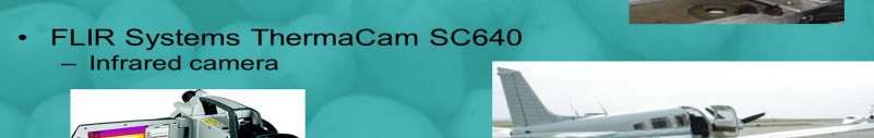
24 Thermal Infrared Imagery

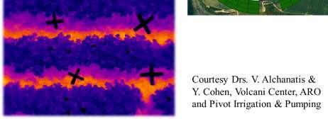
25 Variable Irrigation via Thermal Imaging
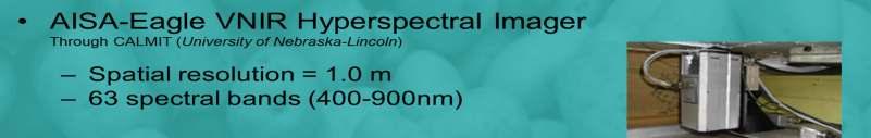
26 Hyperspectral Imagery Collection

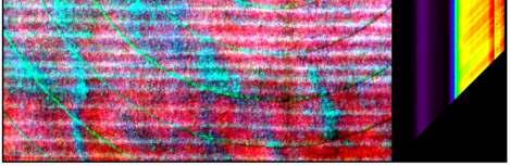
27 Hyperspectral Data Cube (RGB)


28 Hyperspectral Remote Sensing Reflectance at specific narrow band discrete wavelengths across a large continuous spectral range
29 Derivative Spectra The derivative of hyperspectral reflectance data indicates portions of the spectrum where the slope of the reflectance curve changes rapidly
30 Calculate the r 2 coeff. for leaf N content at all hyperspectral reflectance bands Graph r 2 coefficient for all possible combinations of band 1 on the x-axis and band 2 on the y-axis Look for band combinations with low redundancy Lambda-Lambda Plots
31 Best Reflectance Wavelengths? The greatest information about plant characteristics with multiple narrow bands includes the longer red wavelengths ( nm), shorter green wavelengths ( nm), red-edge (720 nm), and NIR ( nm and 982 nm) spectral bands The information in these bands is only available in narrow increments of nm, and is easily obscured in broad multispectral bands that are available with older satellites
32 Correlation Between Reflectance and Total N Concentration in Potato Leaf
")
33 Hyperspectral Data Cube (SR8) SR8 = (R 860 /(R 550 *R 780 )


34 Potato Hyperspectral Imagery (SR8 = (R 860 /(R 550 *R 780 )) vs NDVI (NIR-R)/(NIR+R) SR8 Russet Burbank NDVI Alpine Russet
35 Conclusions Spatial resolution of aerial and satellite remote sensing imagery has improved from 100 s of m to sub-meter accuracy Spectral bandwidth has decreased with the advent of hyperspectral remote sensing Return frequency of satellite remote sensing imagery has improved dramatically A variety of useful spectral indices now exist for various precision agriculture applications in potatoes
36 Conclusions Variable-rate nitrogen application reduced total N- application by lbn ac -1 relative to the recommended rate of 241 lbn ac -1, with a significant improvement in yield and no effect on quality Urea produced the highest total yield, while ESN had the lowest ratio of misshapen tubers Remote sensing of NSI based on MTCI or SR8 spectral indices is an effective strategy to determine variable N- rate without impacting tuber quality


37 Thanks! Funding from: David Mulla (612)
Remote Sensing as a Tool to Manage Nitrogen for Irrigated Potato Production
 Remote Sensing as a Tool to Manage Nitrogen for Irrigated Potato Production Brian Bohman, Carl Rosen, and David Mulla Department of Soil, Water, and Climate University of Minnesota Potato Remote Sensing
Volume XVII, Number July Chasing Petioles
 Research & Extension for the Potato Industry of Idaho, Oregon, & Washington Andrew Jensen, Editor. ajensen@potatoes.com; 509-760-4859 www.nwpotatoresearch.com Volume XVII, Number 12 25 July 2017 Chasing
Nutrient status of potatoes grown on compost amended soils as determined by sap nitrate levels.
 Nutrient status of potatoes grown on compost amended soils as determined by sap nitrate levels. Katherine Buckley, Ramona Mohr, Randy Westwood Brandon Research Centre, AAFC Van Coulter, Kristen Phillips,
Nutrient Recommendations for Russet Burbank Potatoes in Southern Alberta
 Revised May 2011 Agdex 258/541-1 Nutrient Recommendations for Russet Burbank Potatoes in Southern Alberta Precise fertilizer application rates are critical for optimal potato production. Sufficient nutrients
Vegetation Remote Sensing
 Vegetation Remote Sensing Huade Guan Prepared for Remote Sensing class Earth & Environmental Science University of Texas at San Antonio November 2, 2005 Outline Why do we study vegetation remote sensing?
NARROW-BAND VEGETATION INDEXES FROM HYPERION AND DIRECTIONAL CHRIS/PROBA DATA FOR CANOPY CHLOROPHYLL DENSITY ESTIMATION IN MAIZE
 NARROW-BAND VEGETATION INDEXES FROM HYPERION AND DIRECTIONAL CHRIS/PROBA DATA FOR CANOPY CHLOROPHYLL DENSITY ESTIMATION IN MAIZE Massimo Vincini, Ermes Frazzi, Paolo D Alessio Università Cattolica del
Biological and Agricultural Engineering Department UC Davis One Shields Ave. Davis, CA (530)
") Exploratory Study to Evaluate the Feasibility of Measuring Leaf Nitrogen Using Silicon- Sensor-Based Near Infrared Spectroscopy for Future Low-Cost Sensor Development Project No.: Project Leader: 08-HORT10-Slaughter
Exploratory Study to Evaluate the Feasibility of Measuring Leaf Nitrogen Using Silicon- Sensor-Based Near Infrared Spectroscopy for Future Low-Cost Sensor Development Project No.: Project Leader: 08-HORT10-Slaughter
Many of remote sensing techniques are generic in nature and may be applied to a variety of vegetated landscapes, including
 Remote Sensing of Vegetation Many of remote sensing techniques are generic in nature and may be applied to a variety of vegetated landscapes, including 1. Agriculture 2. Forest 3. Rangeland 4. Wetland,
ENVI Tutorial: Vegetation Analysis
 ENVI Tutorial: Vegetation Analysis Vegetation Analysis 2 Files Used in this Tutorial 2 About Vegetation Analysis in ENVI Classic 2 Opening the Input Image 3 Working with the Vegetation Index Calculator
HYPERSPECTRAL IMAGING
 1 HYPERSPECTRAL IMAGING Lecture 9 Multispectral Vs. Hyperspectral 2 The term hyperspectral usually refers to an instrument whose spectral bands are constrained to the region of solar illumination, i.e.,
Response of Russet Potato to Source and Rate of Phosphorus Fertilizer Application
 Response of Russet Potato to Source and Rate of Phosphorus Fertilizer Application Samuel Y.C. Essah, Colorado State University Department of Horticulture and Landscape Architecture San Luis Valley Research
Agricultural land-use from space. David Pairman and Heather North
 Agricultural land-use from space David Pairman and Heather North Talk Outline Motivation Challenges Different approach Paddock boundaries Classifications Examples Accuracy Issues Data sources Future possibilities
The Relationship between SPAD Values and Leaf Blade Chlorophyll Content throughout the Rice Development Cycle
 JARQ 50 (4), 329-334 (2016) http://www.jircas.affrc.go.jp The Relationship between SPAD Values and Leaf Blade Chlorophyll Content throughout the Rice Development Cycle Yasuyuki WAKIYAMA* National Agriculture
Thermal Crop Water Stress Indices
 Page 1 of 12 Thermal Crop Water Stress Indices [Note: much of the introductory material in this section is from Jackson (1982).] The most established method for detecting crop water stress remotely is
Relationship between light use efficiency and photochemical reflectance index in soybean leaves as affected by soil water content
 International Journal of Remote Sensing Vol. 27, No. 22, 20 November 2006, 5109 5114 Relationship between light use efficiency and photochemical reflectance index in soybean leaves as affected by soil
Asteroids to Agriculture: Carving a Niche in Earth Observation Using Asteroid Prospecting Instruments on an Earth-Orbiting Cubesat Constellation
 SSC16-XI-02 Asteroids to Agriculture: Carving a Niche in Earth Observation Using Asteroid Prospecting Instruments on an Earth-Orbiting Cubesat Constellation Hannah R. Goldberg, Matthew Beasley, Chris Voorhees
Spectral reflectance: When the solar radiation is incident upon the earth s surface, it is either
 Spectral reflectance: When the solar radiation is incident upon the earth s surface, it is either reflected by the surface, transmitted into the surface or absorbed and emitted by the surface. Remote sensing
DETECTION OF NITROGEN STRESS IN CORN USING DIGITAL AERIAL IMAGING. Sreekala GopalaPillai Lei Tian and John Beal
 DETECTION OF NITROGEN STRESS IN CORN USING DIGITAL AERIAL IMAGING Sreekala GopalaPillai Lei Tian and John Beal ABSTRACT High-resolution color infrared (CIR) aerial images were used for detecting in-field
EO-1 SVT Site: TUMBARUMBA, AUSTRALIA
 EO-1 SVT Site: TUMBARUMBA, AUSTRALIA Background Tumbarumba Tumbarumba Study Area is located in Southern NSW, Australia. (E 148º 15' S 35º 45') and covers 5, hectares of publicly owned Forest Gently undulating
2018 // Potato // HARS // CPB Systemic Trial Pg. 1
 2018 // Potato // HARS // CPB Systemic Trial Pg. 1 CPB Systemic Seed/In-Furrow Trial Hancock, Wisconsin, USA, 2018 Russell Groves, Scott Chapman, Ben Bradford, Linda Crubaugh Department of Entomology,
Grapevine Nutrition: Results of Tissue and Soil Analyses
 Grapevine Nutrition: Results of Tissue and Soil Analyses Carl Rosen University of Minnesota Northern Grape Symposium February 6, 2013 Rochester, NY Collaborators Paul Domoto, Iowa State University James
THE APPLICATION OF THE WEIGHTED NEAR-INFRARED - RED VEGETATION INDEX FOR ESTIMATING LAI AT THE VEGETATIVE AND GENERATIVE STAGE OF CEREALS
 THE APPLICATION OF THE WEIGHTED NEAR-INFRARED - RED VEGETATION INDEX FOR ESTIMATING LAI AT THE VEGETATIVE AND GENERATIVE STAGE OF CEREALS J.G.P.W. Clevers Wageningen Agricultural University Dept. of Landsurveying
Analyzing spatial and temporal variation of water balance components in La Vi catchment, Binh Dinh province, Vietnam
 Analyzing spatial and temporal variation of water balance components in La Vi catchment, Binh Dinh province, Vietnam Nguyen Duy Liem, Vo Ngoc Quynh Tram, Nguyen Le Tan Dat, Nguyen Kim Loi Nong Lam University-
DATA COLLECTION AND ANALYSIS METHODS FOR DATA FROM FIELD EXPERIMENTS
 DATA COLLECTION AND ANALYSIS METHODS FOR DATA FROM FIELD EXPERIMENTS S. Shibusawa and C. Haché Faculty of Agriculture, Tokyo University of Agriculture and Technology, Japan Keywords: Field experiments,
Land Surface Temperature Measurements From the Split Window Channels of the NOAA 7 Advanced Very High Resolution Radiometer John C.
 Land Surface Temperature Measurements From the Split Window Channels of the NOAA 7 Advanced Very High Resolution Radiometer John C. Price Published in the Journal of Geophysical Research, 1984 Presented
GNR401 Principles of Satellite Image Processing
 Principles of Satellite Image Processing Instructor: Prof. CSRE, IIT Bombay bkmohan@csre.iitb.ac.in Slot 5 Guest Lecture PCT and Band Arithmetic November 07, 2012 9.30 AM 10.55 AM IIT Bombay Slide 1 November
Ecosystems. 1. Population Interactions 2. Energy Flow 3. Material Cycle
 Ecosystems 1. Population Interactions 2. Energy Flow 3. Material Cycle The deep sea was once thought to have few forms of life because of the darkness (no photosynthesis) and tremendous pressures. But
Site Specific Management Center Newsletter, Purdue University, April,
 Using Spectral Vegetation Indices to Differentiate Weeds and Mint in Remote Sensing Images Mary Gumz and Stephen C. Weller Department of Horticulture and Landscape Architecture Introduction Remote sensing-based
APPLICATION OF GENETIC ALGORITHM IN THE MODELING OF LEAF CHLOROPHYLL LEVEL BASED ON VIS/NIR REFLECTION SPECTROSCOPY
 APPLICATION OF GENETIC ALGORITHM IN THE MODELING OF LEAF CHLOROPHYLL LEVEL BASED ON VIS/NIR REFLECTION SPECTROSCOPY Haiqing Yang 1, 2,Yong He 1,* 1 College of Biosystems Engineering and Food Science, Zhejiang
identify tile lines. The imagery used in tile lines identification should be processed in digital format.
 Question and Answers: Automated identification of tile drainage from remotely sensed data Bibi Naz, Srinivasulu Ale, Laura Bowling and Chris Johannsen Introduction: Subsurface drainage (popularly known
Remote Sensing Geographic Information Systems Global Positioning Systems
 Remote Sensing Geographic Information Systems Global Positioning Systems Assessing Seasonal Vegetation Response to Drought Lei Ji Department of Geography University of Nebraska-Lincoln AVHRR-NDVI: July
Drought Estimation Maps by Means of Multidate Landsat Fused Images
 Remote Sensing for Science, Education, Rainer Reuter (Editor) and Natural and Cultural Heritage EARSeL, 2010 Drought Estimation Maps by Means of Multidate Landsat Fused Images Diego RENZA, Estíbaliz MARTINEZ,
Use of the Chlorophyll Meter to Guide In-season Nitrogen Fertilizer Applications in Irrigated Cotton
 Use of the Chlorophyll Meter to Guide In-season Nitrogen Fertilizer Applications in Irrigated Cotton Following water, nitrogen (N) is the most important constraint to upland cotton production. Most of
Forecasting wheat yield in the Canadian Prairies using climatic and satellite data
 Prairie Perspectives 81 Forecasting wheat yield in the Canadian Prairies using climatic and satellite data V. Kumar, University of Manitoba C. E. Haque, Brandon University Abstract: Wheat yield forecasting
The Delaware Environmental Monitoring & Analysis Center
 The Delaware Environmental Monitoring & Analysis Center Tina Callahan Delaware Estuary Science & Environmental Summit 2013 January 27-30, 2013 What is DEMAC? Delaware Environmental Monitoring & Analysis
2010 Crop Year Fertilizer Report
 2010 Crop Year Fertilizer Report This report is based on the tonnage of fertilizer reported from licensed dealers that has been either distributed OR sold in Minnesota 1. Each registrant under section
Monitoring Vegetation Growth of Spectrally Landsat Satellite Imagery ETM+ 7 & TM 5 for Western Region of Iraq by Using Remote Sensing Techniques.
 Monitoring Vegetation Growth of Spectrally Landsat Satellite Imagery ETM+ 7 & TM 5 for Western Region of Iraq by Using Remote Sensing Techniques. Fouad K. Mashee, Ahmed A. Zaeen & Gheidaa S. Hadi Remote
Remote Sensing for Ecosystems
 MODULE GUIDE MSc ENR Remote Sensing for Ecosystems Semester 01 Modul coordinator Lecturers Michael Döring Pascal Ochsner, Diego Tonolla, Diane Whited, Michael Döring Martin Geilhausen Latest update August
LEDStorm Grow Spectrum Light (with EMS Technology) Light Comparison Testing Spokane, WA. A New Natural Approach to Lighting.
 Light Comparison Testing Spokane, WA. A New Natural Approach to Lighting.") Grow Spectrum Light 1.0 Light Comparison Testing Spokane, WA April 12-15th 2016 This was a test to show that the LEDStorm PL11, 75w (Grow Spectrum Light w/ems Technology), with its special array, can be
Grow Spectrum Light 1.0 Light Comparison Testing Spokane, WA April 12-15th 2016 This was a test to show that the LEDStorm PL11, 75w (Grow Spectrum Light w/ems Technology), with its special array, can be
HYPERSPECTRAL VEGETATION INDICES FOR ESTIMATION OF LEAF AREA INDEX
 HYPERSPECTRAL VEGETATION INDICES FOR ESTIMATION OF LEAF AREA INDEX R. Darvishzadeh a, C. Atzberger b, A. K. Skidmore a a International Institute for Geo-information Science and Earth Observation (ITC),
2012 Crop Year Fertilizer Report
 2012 Crop Year Fertilizer Report This report is based on the tonnage of fertilizer reported from licensed dealers that has been either distributed OR sold in Minnesota. Fertilizer can be reported as distributed
Evaluation of rapid field methods for determining the nitrogen status of potato crops
 Evaluation of rapid field methods for determining the nitrogen status of potato crops R. J. Martin New Zealand Institute for Crop & Food Research Limited, Private Bag 474, Christchurch Abstract Petiole
Mapping polar vegetation using UAS
 Mapping polar vegetation using UAS Stein Rune Karlsen, Agnar Sivertsen, Andreas Tøllefsen, Rune Storvold, Bernt Johansen Norut Northern Research Institute Anna Zmarz Warsaw University of Technology Content
Adapt-N: A Cloud Computational Tool for Precision Nitrogen Management. AFRI Project Overview. Harold van Es
 Adapt-N: A Cloud Computational Tool for Precision Nitrogen Management AFRI Project Overview Harold van Es New Tools and Incentives for Carbon, Nitrogen, and Greenhouse Gas Accounting and Management in
Validation of a leaf reflectance and transmittance model for three agricultural crop species
 Validation of a leaf reflectance and transmittance model for three agricultural crop species Application Note Author G. J. Newnham* and T. Burt** *Remote Sensing and Satellite Research Group, Curtin University
Hyperspectral Remote Sensing --an indirect trait measuring method
 Hyperspectral Remote Sensing --an indirect trait measuring method Jin Wu 05/02/2012 Outline Part 1: Terminologies & Tools of RS Techniques Part 2: RS Approaches to Estimating Leaf/Canopy Traits Part 3:
Global UAV-based solutions for the industry and agriculture.
 Global UAV-based solutions for the industry and agriculture. Remote sensing of vegetation from drones (UAS). The example of the Trimble Unmanned Aerial Solution Emmanuel de Maistre, co-founder & CEO demaistre@redbird.fr
What is a vegetation index?
 Vegetation indexes What is a vegetation index? A tool: a vegetation index is a mathematical formula used to estimate the likelihood of vegetation presence in remotely sensed data A product: the result
Reduced Rhizoctonia solani and Streptomyces sp. infection by using combined microbial inocula on organic potato
 Reduced Rhizoctonia solani and Streptomyces sp. infection by using combined microbial inocula on organic potato Orsolya Papp, Borbála Biró, Éva Abod, Tímea Jung, Imre Tirczka, Dóra Drexler Introduction,
Title Sorghum/Cotton Rotation under Extreme Deficit Irrigation Conditions. Location Texas Agricultural Research and Extension Center, Halfway, TX
 Title Sorghum/Cotton Rotation under Extreme Deficit Irrigation Conditions Participants James P. Bordovsky, TAES, Lubbock/Halfway Calvin Trostle, TAEX, Lubbock Eduardo Segarra, Texas Tech, TAES, Lubbock
USDA FOREST SERVICE RESEARCH NOTE NE-198
 USDA FOREST SERVICE RESEARCH NOTE NE-198 FOREST SERVICE, U.S. DEPT. OF AGRICULTURE, 6816 MARKET STREET, UPPER DARBY, PA. 19082 -- 2 x 3 NUTRIENT COMPOSITION OF BLADES, $ PETIOLES, AND WHOLE LEAVES FROM
Lecture Topics. 1. Vegetation Indices 2. Global NDVI data sets 3. Analysis of temporal NDVI trends
 Lecture Topics 1. Vegetation Indices 2. Global NDVI data sets 3. Analysis of temporal NDVI trends Why use NDVI? Normalize external effects of sun angle, viewing angle, and atmospheric effects Normalize
Comparison of Wind Speed, Soil Moisture, and Cloud Cover to Relative Humidity to Verify Dew Formation
 Meteorology Senior Theses Undergraduate Theses and Capstone Projects 12-1-2017 Comparison of Wind Speed, Soil Moisture, and Cloud Cover to Relative Humidity to Verify Dew Formation Kelly M. Haberichter
Assessing broadband vegetation indices and QuickBird data in estimating leaf area index of corn and potato canopies
 Field Crops Research 102 (2007) 33 42 www.elsevier.com/locate/fcr Assessing broadband vegetation indices and QuickBird data in estimating leaf area index of corn and potato canopies Jindong Wu a, *, Dong
Reflectivity in Remote Sensing
 Reflectivity in Remote Sensing The amount of absorbance and reflection of white light by a substance is dependent upon the molecular makeup of the substance. Humans have used dyes for years to obtain colors-
Teacher s Discussion Notes Part 1
 Teacher s Discussion Notes Part 1 PHOTOSYNTHESIS Vocabulary: Chlorophyll--A green substance which gives leaves their color. Chlorophyll absorbs energy from sunlight, which a plant uses to make food. Chloroplast--A
Sugar Beet Petiole Tests as a Measure Of Soil Fertility
 Sugar Beet Petiole Tests as a Measure Of Soil Fertility ROBERT J. BROWN 1 The beet grower who owns his farm can maintain the fertility of the soil at a high point with no fear that money spent on surplus
A Regional Microsatellite Constellation with Electric Propulsion In Support of Tuscan Agriculture
 Berlin, 20 th - 24 th 2015 University of Pisa 10 th IAA Symposium on Small Satellites for Earth Observation Student Conference A Regional Microsatellite Constellation with Electric Propulsion In Support
COMPARING BROAD-BAND AND RED EDGE-BASED SPECTRAL VEGETATION INDICES TO ESTIMATE NITROGEN CONCENTRATION OF CROPS USING CASI DATA
 The International Archives of the Photogrammetry, emote Sensing and Spatial Information Sciences, Volume XLI-B7, 2016 XXIII ISPS Congress, 12 19 July 2016, Prague, Czech epublic COMPAING BOAD-BAND AND
Developing and Validating a Model for a Plant Growth Regulator
 Environmental Factors Special Topics Mepiquat Chloride (PIX) K. Raja Reddy Krreddy@pss.msstate.edu Environmental and Cultural Factors Limiting Potential Yields Atmospheric Carbon Dioxide Temperature (Extremes)
Enhancement of the U.S. Drought Monitor Through the Integration of NASA Vegetation Index Imagery
 Enhancement of the U.S. Drought Monitor Through the Integration of NASA Vegetation Index Imagery Project and Related Activities at USGS/EROS Jim Verdin, Jesslyn Brown, Yingxin Gu, Gail Schmidt, Troy McVay
Hyper Spectral Measurements as a Method for Potato Crop Characterization
 Cloud Publications International Journal of Advanced Remote Sensing and GIS 2013, Volume 2, Issue 1, pp. 122-129, Article ID ISSN 2320-0243 Research Article Open Access Hyper Spectral Measurements as a
Climate Change and Vegetation Phenology
 Climate Change and Vegetation Phenology Climate Change In the Northeastern US mean annual temperature increased 0.7 C over 30 years (0.26 C per decade) Expected another 2-6 C over next century (Ollinger,
Landuse and Landcover change analysis in Selaiyur village, Tambaram taluk, Chennai
 Landuse and Landcover change analysis in Selaiyur village, Tambaram taluk, Chennai K. Ilayaraja Department of Civil Engineering BIST, Bharath University Selaiyur, Chennai 73 ABSTRACT The synoptic picture
Comparison of Scaled Canopy Temperatures with Measured Results under Center Pivot Irrigation
 Comparison of Scaled Canopy Temperatures with Measured Results under Center Pivot Irrigation R. Troy Peters, Ph.D. USDA-ARS, P.O. Drawer, Bushland, TX 79, tpeters@cprl.ars.usda.gov. Steven R. Evett, Ph.D.
ISO MODIS NDVI Weekly Composites for Canada South of 60 N Data Product Specification
 ISO 19131 MODIS NDVI Weekly Composites for South of 60 N Data Product Specification Revision: A Data specification: MODIS NDVI Composites for South of 60 N - Table of Contents - 1. OVERVIEW... 3 1.1. Informal
Precision Ag. Technologies and Agronomic Crop Management. Spatial data layers can be... Many forms of spatial data
 Components of Precision Agriculture Precision Ag. Technologies and Agronomic Crop Management R.L. (Bob) Nielsen Purdue Univ, Agronomy Dept. West Lafayette, Indiana Equipment control Equipment monitoring
Infrared Images and Land Cover in the Past
 Ekológia (Bratislava) Vol. 32, No. 4, p. 383 387, 2013 doi:10.2478/eko-2013-0036 Infrared Images and Land Cover in the Past Václav Ždímal Mendel University in Brno, Zemědělská 1, 613 00 Brno, Czech Republic;
CLIMATE-SMART AGRICULTURE: THE POTENTIAL ROLE OF MODELLING AS PART OF
 CLIMATE-SMART AGRICULTURE: THE POTENTIAL ROLE OF MODELLING AS PART OF THE SOLUTION FOR THE CARIBBEAN Michael A. Taylor Climate Studies Group, Mona University of the West Indies, Mona. IN THE CONTEXT OF
The Arable Mark: Accuracy and Applications
 The Arable Mark: Accuracy and Applications January 7, 2018 Overview Physical and Biological Observations Precipitation Air temperature, humidity, pressure Shortwave (SW) radiation (down & upwelling) Longwave
Remote detection of giant reed invasions in riparian habitats: challenges and opportunities for management planning
 Remote detection of giant reed invasions in riparian habitats: challenges and opportunities for management planning Maria do Rosário Pereira Fernandes Forest Research Centre, University of Lisbon Number
Environmental Plant Physiology Photosynthesis - Aging. Department of Plant and Soil Sciences
 Environmental Plant Physiology Photosynthesis - Aging krreddy@ra.msstate.edu Department of Plant and Soil Sciences Photosynthesis and Environment Leaf and Canopy Aging Goals and Learning Objectives: To
Developing a protocol to use remote sensing as a cost effective tool to monitor contamination of mangrove wetlands
 Developing a protocol to use remote sensing as a cost effective tool to monitor contamination of mangrove wetlands Johannes H. Schellekens, Fernando Gilbes-Santaella, Augustine Rodriguez-Roman, and Belyneth
Assessing Rice Chlorophyll Content with Vegetation Indices from Hyperspectral Data
 Assessing Rice Chlorophyll Content with Vegetation Indices from Hyperspectral Data Xingang Xu, Xiaohe Gu, Xiaoyu Song, Cunjun Li, and Wenjiang Huang National Engineering Research Center for Information
School on Modelling Tools and Capacity Building in Climate and Public Health April Remote Sensing
 2453-5 School on Modelling Tools and Capacity Building in Climate and Public Health 15-26 April 2013 Remote Sensing CECCATO Pietro International Research Institute for Climate and Society, IRI The Earth
Photosynthesis - Aging Leaf Level. Environmental Plant Physiology Photosynthesis - Aging. Department of Plant and Soil Sciences
 Environmental Plant Physiology Photosynthesis and Environment Leaf and Canopy Aging krreddy@ra.msstate.edu Department of Plant and Soil Sciences Goals and Learning Objectives: To understand the effects
Integrating Traditional Handheld Remotely Sensed Measurement Techniques with Chemometric Analyses in the Classroom
 Integrating Traditional Handheld Remotely Sensed Measurement Techniques with Chemometric Analyses in the Classroom Authors Kevin P. Price 1, Thomas J. Prebyl 2, Nan An 3, Nathan R. Myers 4, Yared M. Assefa
An AOTF-based hyperspectral imaging system for eld use in ecophysiological and agricultural applications
 int. j. remote sensing, 2001, vol. 22, no. 18, 3883 3888 An AOTF-based hyperspectral imaging system for eld use in ecophysiological and agricultural applications Y. INOUE National Institute of Agro-Environmental
Growth Stages of Wheat: Identification and Understanding Improve Crop Management
 Growth Stages of Wheat: Identification and Understanding Improve Crop Management B y Travis D. Miller Understanding growth stages of wheat is important in matching management decisions and inputs with
DEVELOPMENT OF NEW NON-DESTRUCTIVE IMAGING TECHNIQUES FOR ESTIMATING CROP GROWTH AND NUTRIENT STATUS. Mahdi M. Ali
 DEVELOPMENT OF NEW NON-DESTRUCTIVE IMAGING TECHNIQUES FOR ESTIMATING CROP GROWTH AND NUTRIENT STATUS A Thesis submitted to University of Technology Sydney by Mahdi M. Ali In accordance with the requirements
Learning Objectives. Thermal Remote Sensing. Thermal = Emitted Infrared
 November 2014 lava flow on Kilauea (USGS Volcano Observatory) (http://hvo.wr.usgs.gov) Landsat-based thermal change of Nisyros Island (volcanic) Thermal Remote Sensing Distinguishing materials on the ground
Evaluation of Total Chlorophyll Content in Microwave-Irradiated Ocimum basilicum L.
 Evaluation of Total Chlorophyll Content in Microwave-Irradiated Ocimum basilicum L. I. Lung a, M.L. Soran a*, M. Stan a, C. Bele b, C. Matea b a National Institute for Research and Development of Isotopic
PNCD ORIZONT
 PNCD ORIZONT 2000 2000-2002 Assimilation of remotely-sensed data of high repetitivity in process models ICPA Bucharest - ICPPT Fundulea contribution to the ADAM Project (2000-2002 period) Project manager:
Assessing Drought in Agricultural Area of central U.S. with the MODIS sensor
 Assessing Drought in Agricultural Area of central U.S. with the MODIS sensor Di Wu George Mason University Oct 17 th, 2012 Introduction: Drought is one of the major natural hazards which has devastating
3. Potato / HARS / CPB Systemic Trial
 Potato / HARS / CPB Systemic Trial 1 3. Potato / HARS / CPB Systemic Trial Soil-applied crop protectants in potato production for full-season pest management and yield enhancement Hancock Agricultural
Evaluation of Physio-Agronomic and Chemical Traits in Relation to The Productivity of Eggplant (Solanum Melongena L.)
") Tropical Agricultural Research Vol. 16: 14-24 (2004) Evaluation of Physio-Agronomic and Chemical Traits in Relation to The Productivity of Eggplant (Solanum Melongena L.) T.K. Illangakoon, D.C Bandara
Tropical Agricultural Research Vol. 16: 14-24 (2004) Evaluation of Physio-Agronomic and Chemical Traits in Relation to The Productivity of Eggplant (Solanum Melongena L.) T.K. Illangakoon, D.C Bandara
Variability of Reference Evapotranspiration Across Nebraska
 Know how. Know now. EC733 Variability of Reference Evapotranspiration Across Nebraska Suat Irmak, Extension Soil and Water Resources and Irrigation Specialist Kari E. Skaggs, Research Associate, Biological
Appendix 2b. NRCS Soil Survey
 Appendix 2b NRCS Soil Survey 118 19' 25'' W Nonirrigated Capability Class Antelope Valley Area, California (Del Sur Solar Site) 118 17' 28'' W 378900 379200 379500 379800 380100 380400 380700 381000 381300
Lesson 4b Remote Sensing and geospatial analysis to integrate observations over larger scales
 Lesson 4b Remote Sensing and geospatial analysis to integrate observations over larger scales We have discussed static sensors, human-based (participatory) sensing, and mobile sensing Remote sensing: Satellite
Predicting Growing Season Grassland Production in the Spring using Sea Surface Temperatures, NDVI, and Grass-Cast
 Predicting Growing Season Grassland Production in the Spring using Sea Surface Temperatures, NDVI, and Grass-Cast William Parton 1, Melannie Hartman 1, Maosi Chen 1, Stephen Del Grosso 1,2, Justin Derner
DROUGHT RISK EVALUATION USING REMOTE SENSING AND GIS : A CASE STUDY IN LOP BURI PROVINCE
 DROUGHT RISK EVALUATION USING REMOTE SENSING AND GIS : A CASE STUDY IN LOP BURI PROVINCE K. Prathumchai, Kiyoshi Honda, Kaew Nualchawee Asian Centre for Research on Remote Sensing STAR Program, Asian Institute
Prediction of soil properties with NIR data and site descriptors using preprocessing and neural networks
 Prediction of soil properties with NIR data and site descriptors using preprocessing and neural networks Matt Aitkenhead Malcolm Coull Jean Robertson 1 Introduction to NSIS A component of the Scottish
Vegetation Change Detection of Central part of Nepal using Landsat TM
 Vegetation Change Detection of Central part of Nepal using Landsat TM Kalpana G. Bastakoti Department of Geography, University of Calgary, kalpanagb@gmail.com Abstract This paper presents a study of detecting
Cereal Staging Guide
 Cereal Staging Guide Introduction Accurate crop staging is essential to ensure crop safety and the optimal performance of crop protection products and agronomic supplements including In-Crop Urea Ammonium
Do More Inputs Increase Soybean Yield AND Profitability?
 Do More Inputs Increase Soybean Yield AND Profitability? - David Marburger*, Bryson Haverkamp, Randy Laurenz, John Orlowski, Eric Wilson, Shaun Casteel, Chad Lee, Seth Naeve, Emerson Nafziger, Kraig Roozeboom,
Detection of Chlorophyll Content of Rice Leaves by Chlorophyll Fluorescence Spectrum Based on PCA-ANN Zhou Lina1,a Cheng Shuchao1,b Yu Haiye2,c 1
 7th International Conference on Mechatronics, Control and Materials (ICMCM 2016) Detection of Chlorophyll Content of Rice Leaves by Chlorophyll Fluorescence Spectrum Based on PCA-ANN Zhou Lina1,a Cheng
Assessment of Vegetation Photosynthesis through Observation of Solar Induced Fluorescence from Space
 Assessment of Vegetation Photosynthesis through Observation of Solar Induced Fluorescence from Space Executive Summary 1. Introduction The increase in atmospheric CO 2 due to anthropogenic emissions, and
Testing the Sensitivity of Vegetation Indices for Crop Type Classification Using Rapideye Imagery
 Testing the Sensitivity of Vegetation Indices for Crop Type Classification Using Rapideye Imagery Mustafa USTUNER and Fusun BALIK SANLI, Turkey Keywords: Remote Sensing, Agriculture, Geoinformation SUMMARY
Irrigation water salinity limits faba bean (Vicia faba L.) photosynthesis
 photosynthesis") 5 th CASEE Conference Healthy Food Production and Environmental Preservation The Role of Agriculture, Forestry and Applied Biology Irrigation water salinity limits faba bean (Vicia faba L.) photosynthesis
5 th CASEE Conference Healthy Food Production and Environmental Preservation The Role of Agriculture, Forestry and Applied Biology Irrigation water salinity limits faba bean (Vicia faba L.) photosynthesis
Estimation of Wavelet Based Spatially Enhanced Evapotranspiration Using Energy Balance Approach
 Estimation of Wavelet Based Spatially Enhanced Evapotranspiration Using Energy Balance Approach Dr.Gowri 1 Dr.Thirumalaivasan 2 1 Associate Professor, Jerusalem College of Engineering, Department of Civil