Crustal Velocity Structure from Surface Wave Dispersion Tomography in the Indian Himalaya
|
|
|
- Brendan Holmes
- 5 years ago
- Views:
Transcription
1 Crustal Velocity Structure from Surface Wave Dispersion Tomography in the Indian Himalaya Warren Caldwell Stanford University Page 33 in Extended Abstracts volume
2 Partial Melt in the Mid-Crust of the Northwest Indian Himalaya Revealed by Rayleigh Wave Dispersion Warren Caldwell, Simon Klemperer, S.S. Rai, and Jesse Lawrence In review in Tectonophysics 2

3 Data Source Thank you to Dr. S.S. Rai and the Seismic Tomography Group at NGRI (and Cambridge University) for collecting and sharing these data. 16 station, 3C, broadband seismic array: Mix of Guralp 3T and Guralp 3ESP sensors Active in ~500 km array length 35 km average station spacing 3
4 Outline Geologic setting & motivation Background on surface wave dispersion Study area and data Methods Results Conclusions 4
5 Outline Geologic setting & motivation Background on surface wave dispersion Study area and data Methods Results Conclusions 5

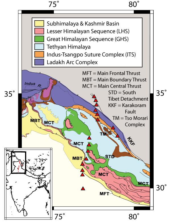
6 Geologic Setting 6

 Brittle thrust faulting")
7 Motivation: Competing models of deformation Channel flow (e.g. Beaumont et al., 2001) Brittle thrust faulting (e.g. Srivastava and Mitra, 1994) 7
8 Outline Geologic setting & motivation Background on surface wave dispersion Study area and data Methods Results Conclusions 8
9 Background: Surface wave dispersion Dispersion is the variation of velocity with period: Longer period waves displace the deeper earth, which has a higher seismic velocity, and therefore travel faster. Sensitive primarily to shear wave velocity. Types of surface waves: Rayleigh waves / Love waves Fundamental mode / higher modes Group velocity / phase velocity 9
10 Outline Geologic setting & motivation Background on surface wave dispersion Study area and data Methods Results Conclusions 10
11 Event selection & categorization I 36 local events Source-receiver spacing < 900km Minimize path averaging over longer paths All events magnitude 4 to 6+ Only source-receiver paths lying mostly or fully within four geologic provinces: Tibetan Plateau Ladakh arc complex Indus Tsangpo Suture Himalayan thrust belt (GHS, LHS, Subhimalaya) 11
12 Event selection & categorization II 12
13 Outline Geologic setting & motivation Background on surface wave dispersion Study area and data Methods Results Conclusions 13
14 Methods I: Pick dispersion curves Pick Rayleigh wave group velocity dispersion curves. multiple filter technique (Dziewonski et al., 1969) phase-matched filter (Herrin and Goforth, 1977) implementation of Herrmann and Ammon (2002) Typical dispersion curve: 6 < T < 50 sec. Corresponds roughly to sensitivity in the 9 75 km depth range. 14
15 Methods II: Invert to get 1-D Vs Invert each dispersion curve to obtain a 1-D shear wave velocity model. Invert to 150km depth, but only consider upper 75 km. Starting model based on average crustal value. 15
16 Methods III: Calculate final models Sort models into geologic regions. Discard outlying models within each region. The mean of the remaining models in each group represents the velocity structure for that region. 16
17 Outline Geologic setting & motivation Background on surface wave dispersion Study area and data Methods Results Conclusions 17

18 Results: Dispersion curves Higher velocities in the Ladakh arc complex, lower in all other regions. 18
19 Results: Dispersion and Models Low-velocity layer at ~20-40 km depth. Significant deviation from starting model (black). 19
20 Results: Models and geologic provinces Low-velocity layer shallows to the south and disappears somewhere south of the Indus Tsangpo Suture. 20
21 Results: Comparison to MT Spatial correspondence between low-velocity and low-resistivity from MT data of Arora et al. (2007). 21
22 Outline Geologic setting & motivation Background on surface wave dispersion Study area and data Methods Results Conclusions 22
23 Conclusions I No dry, melt-free lithologies can account for the velocities we observe: Vs < 3.4 km/s at 30 km depth. Possible explanations for low seismic velocity: Elevated temperature Presence of aqueous fluids Presence of melts These three phenomena are interlinked, and force the conclusion that partial melts are present. 23
24 Conclusions II Spatial correlation of low velocity and low resistivity suggest a common cause. Possible causes for low-resistivity: Partial melts Aqueous fluids Graphite Partial melts, or partial melts and aqueous fluids, are the only explanations that satisfy both sets of observations. 24
25 Thanks again to the NGRI Seismic Tomography Group for collecting and sharing these data. 25
V. Sajama, Bolivia. Kevin M. Ward, George Zandt, Susan L. Beck, Ryan C. Porter, Lara S. Wagner, Estela Minaya, Hernando Tavera
 V. Sajama, Bolivia Kevin M. Ward, George Zandt, Susan L. Beck, Ryan C. Porter, Lara S. Wagner, Estela Minaya, Hernando Tavera Central Andean Plateau (CAP) Average elevation ~4 km Max width ~300 km Total
Crustal Structure of NW Himalaya through Gravity and Magnetic Data Analysis
 P-128 Crustal Structure of NW Himalaya through Gravity and Rambhatla G. Sastry, Ved Pal Singh* Summary Here, our regional gravity and magnetic profiles spanning approximately ~1220 km and ~1120 km respectively
Journal of Geophysical Research: Solid Earth
 RESEARCH ARTICLE Key Points: Moho depths exceed 85 km in new crustal models for western Tibet Moho steps are absent in West Tibet until a 2 3 km step at the Altyn-Tagh Fault A midcrustal low-velocity zone
2008 Monitoring Research Review: Ground-Based Nuclear Explosion Monitoring Technologies
 FINITE-FREQUENCY SEISMIC TOMOGRAPHY OF BODY WAVES AND SURFACE WAVES FROM AMBIENT SEISMIC NOISE: CRUSTAL AND MANTLE STRUCTURE BENEATH EASTERN EURASIA Yong Ren 2, Wei Zhang 2, Ting Yang 3, Yang Shen 2,and
Contract No. F
 Regional Wave Propagation Characteristics in China and Southern Asia James Ni, Richard Rapine, Jianxin Wu and Thomas Hearn New Mexico State University, Department of Physics Las Cruces, NM 88003 Contract
Application of Phase Matched Filtering on Surface Waves for Regional Moment Tensor Analysis Andrea Chiang a and G. Eli Baker b
 1 2 3 4 5 6 7 8 9 10 11 12 13 14 15 16 17 18 19 20 21 22 23 24 25 26 27 28 29 30 31 Application of Phase Matched Filtering on Surface Waves for Regional Moment Tensor Analysis Andrea Chiang a and G. Eli
Supporting Online Material for
 www.sciencemag.org/cgi/content/full/326/5949/112/dc1 Supporting Online Material for Global Surface Wave Tomography Using Seismic Hum Kiwamu Nishida,* Jean-Paul Montagner, Hitoshi Kawakatsu *To whom correspondence
The Afar Rift Consortium
 The Afar Rift Consortium University of Bristol University of Oxford University of Cambridge British Geological Survey University of Rochester University of Auckland, NZ Opportunistic programme following
Reconstruction of Subsurface Structures from Ambient Seismic Noise in Jakarta Area
 Reconstruction of Subsurface Structures from Ambient Seismic Noise in Jakarta Area Sri Widiyantoro 1 Andri Dian Nugraha 1 Zulfakriza 2 Bayu Pranata 3 1 Global Geophysics Research Group, Faculty of Mining
DR
 DR2003071 0 0 270 0 30 0 90 0 60 0 120 0 150 0 90 0 180 0 180 0 A) RadialReceiverFunctions B ackazimuth (in degrees relative to north) -135-90 -45 0 45 90 135 180-5.0-2.5 Tangential R eceiver Functions
Earthquakes How and Where Earthquakes Occur
 Earthquakes How and Where Earthquakes Occur PPT Modified from Troy HS Is there such thing as earthquake weather? Absolutely NOT!!! Geologists believe that there is no connection between weather and earthquakes.
Deformation of Rocks. Orientation of Deformed Rocks
 Deformation of Rocks Folds and faults are geologic structures caused by deformation. Structural geology is the study of the deformation of rocks and its effects. Fig. 7.1 Orientation of Deformed Rocks
Earthquakes. Pt Reyes Station 1906
 Earthquakes Pt Reyes Station 1906 Earthquakes Ground shaking caused by the sudden release of accumulated strain by an abrupt shift of rock along a fracture in the earth. You Live in Earthquake Country
Section 2: How Mountains Form
 Section 2: How Mountains Form Preview Objectives Mountain Ranges and Systems Plate Tectonics and Mountains Types of Mountains Objectives Identify the types of plate collisions that form mountains. Identify
SURFACE WAVE GROUP VELOCITY MEASUREMENTS ACROSS EURASIA
 SURFACE WAVE GROUP VELOCITY MEASUREMENTS ACROSS EURASIA A. L. Levshin, M. H. Ritzwoller, and L. I. Ratnikova Department of Physics, University of Colorado at Boulder -Contract Number F49620-95-1-0139 Sponsored
of other regional earthquakes (e.g. Zoback and Zoback, 1980). I also want to find out
. I also want to find out") 4. Focal Mechanism Solutions A way to investigate source properties of the 2001 sequence is to attempt finding well-constrained focal mechanism solutions to determine if they are consistent with those
4. Focal Mechanism Solutions A way to investigate source properties of the 2001 sequence is to attempt finding well-constrained focal mechanism solutions to determine if they are consistent with those
Earthquakes.
 Earthquakes http://quake.usgs.gov/recenteqs/latestfault.htm An earthquake is a sudden motion or shaking of the Earth's crust, caused by the abrupt release of stored energy in the rocks beneath the surface.
Deformation of the Crust
 Deformation of the Crust Review Choose the best response. Write the letter of that choice in the space provided. 1. The state of balance between the thickness of the crust and the depth at which it rides
Crustal Shear Wave Velocities Inferred From Love Wave Group Velocity Dispersion Between Mt. Merapi and Mt. Lawu, Central Java
 International Journal of Basic & Applied Sciences IJBAS-IJENS Vol:12 No:06 38 Crustal Shear Wave Velocities Inferred From Love Wave Group Velocity Dispersion Between Mt. Merapi and Mt. Lawu, Central Java
Lecture 4: Earthquakes and Seismic Waves
 Lecture 4: Earthquakes and Seismic Waves Key Questions 1. What are the sources for EQs in the PNW? 2. What is a seismograph and seismogram? 3. What is the difference between Richter magnitudes and Mercalli
Application of Interferometric MASW to a 3D-3C Seismic Survey
 Shaun Strong* Velseis Pty Ltd School of Earth Sciences, UQ Brisbane, Australia Steve Hearn Velseis Pty Ltd School of Earth Sciences, UQ Brisbane, Australia SUMMARY Multichannel analysis of seismic surface
Ambient Noise Tomography in the Western US using Data from the EarthScope/USArray Transportable Array
 Ambient Noise Tomography in the Western US using Data from the EarthScope/USArray Transportable Array Michael H. Ritzwoller Center for Imaging the Earth s Interior Department of Physics University of Colorado
Global geophysics and wave propagation
 Global geophysics and wave propagation Reading: Fowler p76 83 Remote sensing Geophysical methods Seismology Gravity and bathymetry Magnetics Heat flow Seismology: Directly samples the physical properties
1. A few words about EarthScope and USArray. 3. Tomography using noise and Aki s method
 1. A few words about EarthScope and USArray 2. Surface-wave studies of the crust and mantle 3. Tomography using noise and Aki s method 4. Remarkable images of US crust (and basins)! Unlocking the Secrets
Earthquake patterns in the Flinders Ranges - Temporary network , preliminary results
 Earthquake patterns in the Flinders Ranges - Temporary network 2003-2006, preliminary results Objectives David Love 1, Phil Cummins 2, Natalie Balfour 3 1 Primary Industries and Resources South Australia
25th Seismic Research Review - Nuclear Explosion Monitoring: Building the Knowledge Base
 Pn Q UNDER TIBET AND TIENSHAN WITH PRACTICAL AND SCIENTIFIC IMPLICATIONS Jiakang Xie Lamont-Doherty Earth Observatory, Columbia University Sponsored by Defense Threat Reduction Agency Contract No. DTRA01-00-C-0048
Strike-Slip Faults. ! Fault motion is parallel to the strike of the fault.
 Strike-Slip Faults! Fault motion is parallel to the strike of the fault.! Usually vertical, no hanging-wall/footwall blocks.! Classified by the relative sense of motion. " Right lateral opposite block
NAME HOMEWORK ASSIGNMENT #4 MATERIAL COVERS CHAPTERS 19, 20, 21, & 2
 NAME HOMEWORK ASSIGNMENT #4 MATERIAL COVERS CHAPTERS 19, 20, 21, & 2 Assignment is due the beginning of the class period on December 14, 2004. Mark answers on a scantron sheet, which will be provided.
FINAL EXAM Crustal Deformation CONVERGE DIVERGENT PLATES MANTLE PLUMES FLUX BASALTIC GRANITIC
 Crustal Deformation Reading: Chapter 10 Pages 283-304 Review Questions 4, 6, 7, 10, 12, 15, 18, 20 FINAL EXAM NOON TO 2 PM, TUESDAY DEC. 5 HERE: Natural Science 101 BRING A SCAN TRON TURN IN YOUR REVIEW
Magnetotelluric Studies of Active Continent Continent Collisions
 Surv Geophys (2010) 31:137 161 DOI 10.1007/s10712-009-9086-y Magnetotelluric Studies of Active Continent Continent Collisions Martyn Unsworth Received: 30 January 2009 / Accepted: 1 October 2009 / Published
Global surface-wave tomography
 Global surface-wave tomography Lapo Boschi (lapo@erdw.ethz.ch) October 7, 2009 Love and Rayleigh waves, radial anisotropy Whenever an elastic medium is bounded by a free surface, coherent waves arise that
How to Build a Mountain and other Geologic Structures. But first, questions
 How to Build a Mountain and other Geologic Structures But first, questions Questions your students might ask How were Montana s mountains formed? How old are the mountains? What are the different ways
The continental lithosphere
 Simplicity to complexity: The continental lithosphere Reading: Fowler p350-377 Sampling techniques Seismic refraction Bulk crustal properties, thickness velocity profiles Seismic reflection To image specific
Geophysical Site Investigation (Seismic methods) Amit Prashant Indian Institute of Technology Gandhinagar
 Amit Prashant Indian Institute of Technology Gandhinagar") Geophysical Site Investigation (Seismic methods) Amit Prashant Indian Institute of Technology Gandhinagar Short Course on Geotechnical Aspects of Earthquake Engineering 04 08 March, 2013 Seismic Waves
Geophysical Site Investigation (Seismic methods) Amit Prashant Indian Institute of Technology Gandhinagar Short Course on Geotechnical Aspects of Earthquake Engineering 04 08 March, 2013 Seismic Waves
Effects of Surface Geology on Seismic Motion
 4 th IASPEI / IAEE International Symposium: Effects of Surface Geology on Seismic Motion August 23 26, 2011 University of California Santa Barbara TOMOGRAPHIC ESTIMATION OF SURFACE-WAVE GROUP VELOCITY
FORCES ON EARTH UNIT 3.2. An investigation into how Newton s Laws of Motion are applied to the tectonic activity on Earth.
 FORCES ON EARTH UNIT 3.2 An investigation into how Newton s Laws of Motion are applied to the tectonic activity on Earth. USE THESE NOTES: OUR HOME PLANET EARTH: What do you know about our planet? SO.HOW
Mantle anisotropy across the southwestern boundary of the Ordos block, North China
 Earthq Sci (200)23: 549 553 549 Doi: 0.007/s589-00-0754-2 Mantle anisotropy across the southwestern boundary of the Ordos block, North China, Yongcai Tang Yongshun John Chen Yuanyuan V. Fu 2 Haiyang Wang
Seismogram Interpretation. Seismogram Interpretation
 Travel times in the Earth Ray paths, phases and their name Wavefields in the Earth: SH waves, P-SV waves Seismic Tomography Receiver Functions Seismogram Example Long-period transverse displacement for
revised October 30, 2001 Carlos Mendoza
 Earthquake Sources in the circum-caribbean Region Puerto Rico Tsunami Mitigation and Warning Program Federal Emergency Management Agency Preliminary Report: Task 3 revised October 30, 2001 Carlos Mendoza
Plate Tectonics. I. The Discovery of Plate Tectonics II. A Mosaic of Plates III. Types of Plate Boundaries IV. How Plates Move
 Plate Tectonics I. The Discovery of Plate Tectonics II. A Mosaic of Plates III. Types of Plate Boundaries IV. How Plates Move I. The Discovery of Plate Tectonics A. Continental Drift (Alfred Wegener) Proposed
UNIT - 7 EARTHQUAKES
 UNIT - 7 EARTHQUAKES WHAT IS AN EARTHQUAKE An earthquake is a sudden motion or trembling of the Earth caused by the abrupt release of energy that is stored in rocks. Modern geologists know that most earthquakes
Summary. We present the results of the near-surface characterization for a 3D survey in thrust belt area in Sharjah, United Arab Emirates.
 Near-surface characterization, challenges, and solutions for high-density, high-productivity, Alexander Zarkhidze*, Claudio Strobbia, Abdallah Ibrahim, WesternGeco; Luis Viertel Herrera, Abdulla Al Qadi,
27th Seismic Research Review: Ground-Based Nuclear Explosion Monitoring Technologies
 SEISMIC SOURCE AND PATH CALIBRATION IN THE KOREAN PENINSULA, YELLOW SEA, AND NORTHEAST CHINA Robert B. Herrmann 1, Young-Soo Jeon 1, William R. Walter 2, and Michael E. Pasyanos 2 Saint Louis University
Magnitude 7.5 PALU, INDONESIA
 A magnitude 7.5 earthquake occurred 80.8 km (50.2 mi) north of Palu, Indonesia at a depth of 10 km (6.2 miles). This earthquake triggered a tsunami with wave heights up to 2 m (6.6 ft) that an official
Effect of earth structure and source time function on inversion of singlestation regional surface waves for rupture mechanism and focal depth
 JOURNAL OF THE BALKAN GEOPHYSICAL SOCIETY, Vol. 4, No 4, November 2001, p. 69-90, 14 figs. Effect of earth structure and source time function on inversion of singlestation regional surface waves for rupture
OCN 201 Physiography of the Seafloor
 OCN 201 Physiography of the Seafloor Hypsometric Curve for Earth s solid surface Note histogram Hypsometric curve of Earth shows two modes. Hypsometric curve of Venus shows only one! Why? Ocean Depth vs.
a) b) t h d e 40 N 20 N 60 E 80 E 100 E 60 E 80 E 100 E avearge number of paths in a 2 o x2 o cell
 b) t h d e 40 N 20 N 60 E 80 E 100 E 60 E 80 E 100 E avearge number of paths in a 2 o x2 o cell") Supporting Online Material Thinning and ow of Tibetan crust constrained by seismic anisotropy Nikolai M. Shapiro, Michael H. Ritzwoller, Peter Molnar 2, and Vadim Levin 3 Department ofphysics, University
Supporting Online Material Thinning and ow of Tibetan crust constrained by seismic anisotropy Nikolai M. Shapiro, Michael H. Ritzwoller, Peter Molnar 2, and Vadim Levin 3 Department ofphysics, University
Data Repository: Seismic and Geodetic Evidence For Extensive, Long-Lived Fault Damage Zones
 DR2009082 Data Repository: Seismic and Geodetic Evidence For Extensive, Long-Lived Fault Damage Zones Fault Zone Trapped Wave Data and Methods Fault zone trapped waves observed for 2 shots and 5 local
SOURCE PARAMETERS STUDY OF LOCAL EARTHQUAKES IN THE GARHWAL HIMALAYA REGION BASED ON THE DIGITAL BROADBAND DATA
 SOURCE PARAMETERS STUDY OF LOCAL EARTHQUAKES IN THE GARHWAL HIMALAYA REGION BASED ON THE DIGITAL BROADBAND DATA Hans R WASON 1 And Mukat L SHARMA SUMMARY This paper presents an analysis of 15 local earthquakes
Learning Objectives (LO) What we ll learn today:!
 What we ll learn today:!") Learning Objectives (LO) Lecture 13: Mountain Building Read: Chapter 10 Homework #11 due Tuesday 12pm What we ll learn today:! 1. Define the types of stress that are present in the crust! 2. Define the
Learning Objectives (LO) Lecture 13: Mountain Building Read: Chapter 10 Homework #11 due Tuesday 12pm What we ll learn today:! 1. Define the types of stress that are present in the crust! 2. Define the
Geophysical Journal International
 Geophysical Journal International Geophys. J. Int. (2011) 185, 593 608 doi: 10.1111/j.1365-246X.2011.04979.x 3-D lithospheric structure beneath southern Tibet from Rayleigh-wave tomography with a 2-D seismic
B6 Isostacy. B6.1 Airy and Pratt hypotheses. Geophysics 210 September 2008
 B6 Isostacy B6.1 Airy and Pratt hypotheses Himalayan peaks on the Tibet-Bhutan border In the 19 th century surveyors used plumblines and theodolites to map India. A plumb line was used when measuring the
28th Seismic Research Review: Ground-Based Nuclear Explosion Monitoring Technologies
 GROUND TRUTH HYPOCENTERS AND 3D CRUSTAL VELOCITY STRUCTURE IN CENTRAL ASIA FROM IN-COUNTRY NETWORKS Thomas de la Torre 1, Gaspar Monsalve-Mejia 1, Anne F. Sheehan 1, Charlotte Rowe 2, and Michael Begnaud
The effect of the initial earthquake phase shift on the inversion of regional surface wave recordings for the estimation of crustal structure
 JOURNAL OF THE BALKAN GEOPHYSICAL SOCIETY, Vol., No, May, p. -6, 1 figs. The effect of the initial earthquake phase shift on the inversion of regional surface wave recordings for the estimation of crustal
Lecture notes Bill Engstrom: Instructor Earth s Interior GLG 101 Physical Geology
 Lecture notes Bill Engstrom: Instructor Earth s Interior GLG 101 Physical Geology We memorized the layers of the Earth early in the semester. So, how do we know what s beneath the Earth s surface. In the
DYNAMIC CRUST AND THE EARTH S INTERIOR
 Name DYNAMIC CRUST AND THE EARTH S INTERIOR Regents Earth Science I EARTHQUAKES Earthquake Any natural shaking of the Earth caused by displacement of rock. Terms: (1) Focus- The point within the crust
Directed Reading. Section: How Mountains Form MOUNTAIN RANGES AND SYSTEMS. Skills Worksheet
 Skills Worksheet Directed Reading Section: How Mountains Form 1. How high is Mount Everest? a. about 1980 km above sea level b. more than 8 km below sea level c. more than 8 km above sea level d. more
SEISMIC VELOCITY STRUCTURE OF THE NORTHWESTERN & NORTHEASTERN HIMALAYA AND ITS IMPLICATIONS FOR EARTHQUAKE HAZARD ASSESSMENT
 SEISMIC VELOCITY STRUCTURE OF THE NORTHWESTERN & NORTHEASTERN HIMALAYA AND ITS IMPLICATIONS FOR EARTHQUAKE HAZARD ASSESSMENT UKIERI Thematic Partnership Supriyo Mitra Keith Priestley Motivation ~50 Ma
Dynamic Triggering Semi-Volcanic Tremor in Japanese Volcanic Region by The 2016 Mw 7.0 Kumamoto Earthquake
 Dynamic Triggering Semi-Volcanic Tremor in Japanese Volcanic Region by The 016 Mw 7.0 Kumamoto Earthquake Heng-Yi Su 1 *, Aitaro Kato 1 Department of Earth Sciences, National Central University, Taoyuan
Evolution of Continents Chapter 20
 Evolution of Continents Chapter 20 Does not contain complete lecture notes. Mountain belts Orogenesis the processes that collectively produce a mountain belt Includes folding, thrust faulting, metamorphism,
Scattering and intrinsic attenuation structure in Central Anatolia, Turkey using BRTR (PS-43) array
 array") Scattering and intrinsic attenuation structure in Central Anatolia, Turkey using BRTR (PS-43) array CTBT: Science & Technology 2011 Korhan Umut SEMIN Nurcan Meral OZEL B.U. Kandilli Observatory & Earthquake
Scattering and intrinsic attenuation structure in Central Anatolia, Turkey using BRTR (PS-43) array CTBT: Science & Technology 2011 Korhan Umut SEMIN Nurcan Meral OZEL B.U. Kandilli Observatory & Earthquake
Lateral variations in the crustal structure of the Indo-Eurasian
 submitted to Geophys. J. Int. Lateral variations in the crustal structure of the Indo-Eurasian collision zone Amy Gilligan 1,2, Keith Priestley 2 1 School of Geoscience, University of Aberdeen, Aberdeen,
Before Plate Tectonics: Theory of Continental Drift
 Before Plate Tectonics: Theory of Continental Drift Predecessor to modern plate tectonics Shape and fit of the continents was the initial evidence Snider-Pelligrini (1858) Taylor (1908) Wegner (1915) Fig.
SUPPLEMENTARY INFORMATION
 Inability of additional parameters to resolve the Rayleigh-Love discrepancy Radial anisotropy is introduced to resolve the Rayleigh-Love misfit discrepancy that exists across large regions of the western
Whole Earth Geophysics. Robert J. Lillie
 Whole Earth Geophysics Robert J. Lillie 1 - Geophysical techniques provide information on the internal structure and tectonics development of the earth. - Some of the geophysical methods are: refraction,
SEISMIC EVENT LOCATION STRATEGY AND PATH CALIBRATION IN AND AROUND THE INDIAN SUBCONTINENT. Chandan K. Saikia and Gene Ichinose. URS Group, Inc.
 SEISMIC EVENT LOCATION STRATEGY AND PATH CALIBRATION IN AND AROUND THE INDIAN SUBCONTINENT Chandan K. Saikia and Gene Ichinose URS Group, Inc. Sponsored by Defense Threat Reduction Agency DTRA1--C-33 and
How to Build a Mountain and other Geologic Structures. But first a short review
 How to Build a Mountain and other Geologic Structures But first a short review Where do we see deep earthquakes? What is happening there? What can happen at a plate boundary? 1. Plates can move apart
Q. What is the hypothesis of continental drift? Q. What are the evidences that used to support this hypothesis?
 Q & A 1 Q. What is the hypothesis of continental drift? - That there was a supercontinent called Pangaea that began to break apart about 200 Ma, this was proposed by Alfred Wegener in 1912. Q. What are
Lecture 9 faults, folds and mountain building
 Lecture 9 faults, folds and mountain building Rock deformation Deformation = all changes in size, shape, orientation, or position of a rock mass Structural geology is the study of rock deformation Deformation
Seismic Velocity Structure of Central Asia from Surface-Wave Dispersion
 Seismic Velocity Structure of Central Asia from Surface-Wave Dispersion Brett Ketter, B.S. A Thesis Presented to the Faculty of the Graduate School of Saint Louis University in Partial Fulfillment of the
Depth-dependent slip regime on the plate interface revealed from slow earthquake activities in the Nankai subduction zone
 2010/10/11-14 Earthscope Workshop Depth-dependent slip regime on the plate interface revealed from slow earthquake activities in the Nankai subduction zone Kazushige Obara, ERI, Univ. Tokyo Recurrence
Geophysical Journal International
 Geophysical Journal International Geophys. J. Int. (2014) 199, 1395 1415 GJI Seismology doi: 10.1093/gji/ggu326 Shear-velocity structure, radial anisotropy and dynamics of the Tibetan crust Matthew R.
Faults, folds and mountain building
 Faults, folds and mountain building Mountain belts Deformation Orogens (Oro = Greek all changes for mountain, in size, shape, genesis orientation, = Greek for or formation) position of a rock mass Structural
Northern Tanzanian Earthquakes: Fault orientations, and depth distribution
 Northern Tanzanian Earthquakes: Fault orientations, and depth distribution Stewart Rouse (NC A&T Physics) Penn State University SROP Mentors: Dr. Andy Nyblade & Dr. Rick Brazier July 27, 2005 1.0 Introduction
Regional Resource Area Mapping in Nevada Using the USArray Seismic Network
 Regional Resource Area Mapping in Nevada Using the USArray Seismic Network Glenn Biasi, Ileana Tibuleac, and Leiph Preston Nevada Seismological Laboratory, University of Nevada Reno, Reno, NV 89557 Sandia
Preface and Overview. Folded strata in the mountains of Italy (ca AD), Leonardo da Vinci
, Leonardo da Vinci") Preface and Overview Folded strata in the mountains of Italy (ca. 1500 AD), Leonardo da Vinci Models of Mountain Building and Associated Deformation as represented by G.P. Scrope Deformation Feature: Scales
Preface and Overview Folded strata in the mountains of Italy (ca. 1500 AD), Leonardo da Vinci Models of Mountain Building and Associated Deformation as represented by G.P. Scrope Deformation Feature: Scales
General Seismology or Basic Concepts of Seismology. Göran Ekström
 General Seismology or Basic Concepts of Seismology Göran Ekström Basics Concepts of Seismology Travel Time Ground displacement at Petropavlovsk following the M8.4 Sea of Okhotsk earthquake Ground displacement
2008 Monitoring Research Review: Ground-Based Nuclear Explosion Monitoring Technologies
 STRUCTURE OF THE KOREAN PENINSULA FROM WAVEFORM TRAVEL-TIME ANALYSIS Roland Gritto 1, Jacob E. Siegel 1, and Winston W. Chan 2 Array Information Technology 1 and Harris Corporation 2 Sponsored by Air Force
Global Tectonics. Kearey, Philip. Table of Contents ISBN-13: Historical perspective. 2. The interior of the Earth.
 Global Tectonics Kearey, Philip ISBN-13: 9781405107778 Table of Contents Preface. Acknowledgments. 1. Historical perspective. 1.1 Continental drift. 1.2 Sea floor spreading and the birth of plate tectonics.
The Earth s Structure from Travel Times
 from Travel Times Spherically symmetric structure: PREM - Crustal Structure - Upper Mantle structure Phase transitions Anisotropy - Lower Mantle Structure D D - Structure of of the Outer and Inner Core
Earthquakes. Forces Within Eartth. Faults form when the forces acting on rock exceed the rock s strength.
 Earthquakes Vocabulary: Stress Strain Elastic Deformation Plastic Deformation Fault Seismic Wave Primary Wave Secondary Wave Focus Epicenter Define stress and strain as they apply to rocks. Distinguish
Earth s Interior Earth - Chapter 12 Stan Hatfield Southwestern Illinois College
 Earth s Interior Earth - Chapter 12 Stan Hatfield Southwestern Illinois College Probing Earth s Interior Most of our knowledge of Earth s interior comes from the study of earthquake waves. Travel times
Some aspects of seismic tomography
 Some aspects of seismic tomography Peter Shearer IGPP/SIO/U.C. San Diego September 7, 2009 Earthquake Research Institute Part 1: Global Tomography P velocity perturbations 200 km 1000 km 2700 km MIT 2006
crustal thicknesses. earthquakes as in recorded
 LEVEU 42 P& 4 9 Source: Cornell University, Ithaca NY, Department of Geological Sciences. Contract N00014-75-C-1121 Date: 1979 Title: Pn, Sn Seismic Propagation in the Upper Mantle SUMMARY OF RESULTS OF
Borehole Seismic Monitoring of Injected CO 2 at the Frio Site
 Borehole Seismic Monitoring of Injected CO 2 at the Frio Site * Daley, T M (tmdaley@lbl.gov), Lawrence Berkeley National Lab., 1 Cyclotron Rd, Berkeley, CA 94720 Myer, L (lrmyer@lbl.gov), Lawrence Berkeley
Heterogeneity and anisotropy of the lithosphere of SE Tibet from surface wave array tomography
 JOURNAL OF GEOPHYSICAL RESEARCH, VOL. 115,, doi:10.1029/2009jb007142, 2010 Heterogeneity and anisotropy of the lithosphere of SE Tibet from surface wave array tomography Huajian Yao, 1,2 Robert D. van
Essentials of Geology, 11e
 Essentials of Geology, 11e Crustal Deformation and Mountain Building Chapter 17 Instructor Jennifer Barson Spokane Falls Community College Geology 101 Stanley Hatfield Southwestern Illinois College Jennifer
SHORT PERIOD SURFACE WAVE DISPERSION FROM AMBIENT NOISE TOMOGRAPHY IN WESTERN CHINA. Sponsored by National Nuclear Security Administration 1,2
 SHORT PERIOD SURFACE WAVE DISPERSION FROM AMBIENT NOISE TOMOGRAPHY IN WESTERN CHINA Michael H. Ritzwoller 1, Yingjie Yang 1, Michael Pasyanos 2, Sihua Zheng 3, University of Colorado at Boulder 1, Lawrence
University of Leeds 3GP Geophysics Field Trip Lake Balaton, Hungary
 University of Leeds 3GP Geophysics Field Trip Lake Balaton, Hungary September 1-15, 2007 geological background and logistics Staff: Greg Houseman, Graham Stuart The Alpine-Carpathian-Pannonian System Elevation
Data Repository Item For: Kinematics and geometry of active detachment faulting beneath the TAG hydrothermal field on the Mid-Atlantic Ridge
 GSA Data Repository Item: 2007183 Data Repository Item For: Kinematics and geometry of active detachment faulting beneath the TAG hydrothermal field on the Mid-Atlantic Ridge Brian J. demartin 1*, Robert
Magnitude 7.1 PHILIPPINES
 A magnitude 7.1 earthquake struck in the southeastern Philippines just after 8 am local time Tuesday morning killing 82 people and reducing a 17 th century church to rubble. Offices and schools were closed
ERTH2020 Introduction to Geophysics The Seismic Method. 1. Basic Concepts in Seismology. 1.1 Seismic Wave Types
 ERTH2020 Introduction to Geophysics The Seismic Method 1. Basic Concepts in Seismology 1.1 Seismic Wave Types Existence of different wave types The existence of different seismic wave types can be understood
THE SEISMICITY OF THE EARTH
 OUTLINE THE SEISMICITY OF THE EARTH The earthquake source Types of earthquake: - from impacts and minor tremors to tectonic earthquakes, elastic rebound theory, deep earthquakes. Location of earthquakes:
OCN 201 Physiography of the Seafloor
 OCN 201 Physiography of the Seafloor 1 Ocean Depth versus Continental Height Why do we have dry land? Solid surface of Earth is dominated by two levels: Land with a mean elevation of +840 m (29% of Earth
Imaging the Gutenberg Seismic Discontinuity beneath the Oceanic Crust of the North American Plate
 Imaging the Gutenberg Seismic Discontinuity beneath the Oceanic Crust of the North American Plate Robbie Burgess 11-25-15 Dr. Nicholas Schmerr GEOL 394 1 1. Abstract: The lithosphere-asthenosphere boundary
Upscaling Aspects of Spatial Scaling
 Aspects of Spatial Scaling 288 We need to relate measurements at different scales Lab Logs Crosswell VSP Surface Seismic How does laboratory rock physics apply to the field? frequency differences sample
FORCES ON EARTH. An investigation into how Newton s Laws of Motion are applied to the tectonic activity on Earth.
 FORCES ON EARTH An investigation into how Newton s Laws of Motion are applied to the tectonic activity on Earth. GEOLOGY Geologists scientists who study the forces that make and shape the Earth Geologists
Lecture Outlines PowerPoint. Chapter 10 Earth Science, 12e Tarbuck/Lutgens
 Lecture Outlines PowerPoint Chapter 10 Earth Science, 12e Tarbuck/Lutgens 2009 Pearson Prentice Hall This work is protected by United States copyright laws and is provided solely for the use of instructors
27th Seismic Research Review: Ground-Based Nuclear Explosion Monitoring Technologies
 P AND S WAVE VELOCITY STRUCTURE OF THE CRUST AND UPPER MANTLE UNDER CHINA AND SURROUNDING AREAS FROM BODY AND SURFACE WAVE TOMOGRAPHY M. Nafi Toksöz, Robert D. Van der Hilst, Youshun Sun, and Chang Li
SUPPLEMENTARY INFORMATION
 SUPPLEMENTARY INFORMATION Supplementary online material for Bai et al., (2). EHS3D MT data collection Broadband magnetotelluric (MT) data were recorded on profiles P, P2 and P4 in the frequency band -.5