Pre-Feasibility Report for Drilling of ERD Wells in Baghjan Area in Tinsukia District in the State of Assam
|
|
|
- Percival Johnson
- 5 years ago
- Views:
Transcription
1 Pre-Feasibility Report for Drilling of ERD Wells in Baghjan Area in Tinsukia District in the State of Assam 1.0 PREAMBLE: India is one of the fastest growing economies in the world with the demand for oil and gas rising at a matching rate and the dependence on fossil fuels is likely to continue in the foreseeable future. The imports of crude oil during , in terms of quantity was MMT valued at USD 142 billion. During the period to the crude oil production has remained in the range 33.7 to 38.1 MMT with year to year variations. Natural gas production was also in the range of BCM in to BCM in In order to address the country's energy security concerns, one of the measures undertaken by the Government has been the implementation of the New Exploration Licensing Policy (NELP). For exploration of hydrocarbon resources in the country Petroleum Exploration Licenses are granted under the New Exploration Licensing Policy (NELP). India has an estimated sedimentary area of 3.14 million sq km. comprising of 26 sedimentary basins, out of which, 1.35 million sq km. area is in deepwater and 1.79 million sq km. area is in onland and shallow offshore. Before implementing the New Exploration Licensing Policy (NELP) in 1999, 11% of Indian sedimentary basins were under exploration, which has now increased significantly. Oil India Limited (OIL), a Government of India Navaratna Enterprise, is currently engaged in carrying out exploration activities for hydrocarbon in its operational areas of Upper Assam, Arunachal Pradesh and Mizoram in the North Eastern part of India. OIL has significant presence in pan-india and overseas. Following the discovery of oil and gas in Baghjan area (2003) by OIL, extensive geoscientific works have been carried out in by 3D seismic survey. Around 75 sqkm of PEL area was converted into Baghjan Mining Lease and OIL has so far drilled 19 wells. Currently 5000 bbl of oil has been produced from this field per day. Gas wells are being kept in shut in condition due to non-availability of evacuation infra-structure. Due to presence of ML boundary towards north of Baghjan ML as well as the Dangori river and Dibru-Saikhowa National Park (DSNP), further exploration work could not be continued beyond the ML boundary towards northern side. However, it has been observed from the geoscientific data that the oil/gas 1
 extension/appraisal locations in this area to prove the limit of these oil/gas bearing horizons beyond the ML boundary and below the DSNP park.")

2 bearing sands are continuous below the river bed and further beneath of DSNP park. Oil India Limited intends to drill seven (7) extension/appraisal locations in this area to prove the limit of these oil/gas bearing horizons beyond the ML boundary and below the DSNP park. Once hydrocarbon is established in this area, it is expected to enhance the cumulative oil production of OIL adding to the national economy. Therefore drilling is required to commence as early as possible after obtaining of pre drilling EIA & EMP and NBWL clearance. All seven locations are planned from the existing plinth of 3 existing well plinths of Baghjan ML at a distance of maximum about 2 km with target depth of 3950 m (TVD) each. The paras below provide details of the Project as per guidelines of Ministry of Environment and Forests circular no. J-11013/41/2006-IA.II(I) dated All other relevant information pertaining to the Block and Activity is enumerated under the respective heads of the enclosed Form 1. LOCATION MAP OF THE BLOCK AREA, TINSUKIA DISTRICT, ASSAM 2

3 Physiographic map of Baghjan Area 3
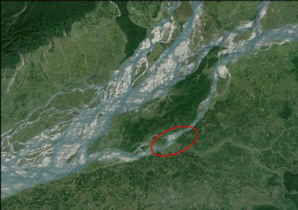
4 2.0 GEOGRAPHICAL POSITION OF THE ERD BAGHJAN LOCATIONS The ERD locations (sub-surface) lie in Dibru-Saikhowa National Park (DSNP) with the Dangori River flowing south marking the southern boundary of the national park in Tinsukia district of Assam and the mighty Brahmaputra River marking the northern boundary of DSNP area. The coordinates of the proposed drilling locations are given in Table 1 and in Figure 1. Figure-1 Table-1 POINT Latitude Longitude A 27 36' "N 95 21' "E B 27 36' "N 95 22' "E C 27 36' "N 95 22' "E D 27 36' "N 95 22' "E E 27 37'7.9496"N 95 23'7.0839"E F G 27 37'5.1939"N 27 37' "N 95 23' "E 95 24'6.0105"E 4
5 3.0 TECHNICAL FEASIBILITY FOR DRILLING OF BAGHJAN ERD WELLS: Location of the Block Baghjan ERD locations are located within the proven petroliferous Assam- Arakan Basin. The Assam Shelf, Belt of Schuppen and the Assam-Arakan Fold Belt are the prime geological features of the Assam-Arakan Shelf-Slope basinal system. Baghjan is geologically located in the vicinity of already proven fields in Assam Plains with major oilfields like Barekuri, Makum-Hapjan, Borhapjan in south and Mechaki field in north-east having established Oligocene-Eocene (Barail-Lakadong+Therria) hydrocarbon system. Towards immediate south of the proposed ERD locations, commercial oil and gas field (Baghjan) have been discovered way back in 2003 and subsequently, developed by drilling of 19 wells till date. These ERD locations are the northern extension of the same Baghjan structure towards north below the periphery of Dibru Saikhowa National Park (DSNP). Earlier Exploration in adjacent Baghjan Area Baghjan structure was identified way back in 1991 based on limited seismic data and later re-defined based on additional 2D seismic of The presence of commercial hydrocarbon in the area was first established in the first well (Baghjan-1) drilled in the structure in March 2003, when two sands within Lakadong+Therria produced gas with minor amount of light oil/condensate. In , the Baghjan area was covered with 3D seismic for further development of the field. It is worth mentioning that subsequent wells (19 Nos.) proved to be oil and gas bearing. Geophysical Survey In DSNP Park area, no geophysical activities have been carried out so far by OIL due to environmental restriction. However, as referred earlier the entire Baghjan oilfield has been covered with extensive 2D and 3D seismic surveys. Exploratory Drilling No wells have been drilled in the DSNP area till date. OIL is planning to drill ERD wells with high technology to drill 7 wells from the existing plinth of Baghjan PML. 5
6 Technical Assessment & Geological Modeling Based on the overall geoscientific studies carried out in Baghjan area, 7 (seven) drillable prospects have been identified inside DSNP area. Also, should there be any drilling in this area, more subsurface data becomes available, the above locations may have to be shifted/ optimally placed, if required. The coordinates of the identified drillable prospects are shown in Table 2. Table 2 Sl. No. Location Latitude Longitude 1 A 27 36' "N 95 21' "E 2 B 27 36' "N 95 22' "E 3 C 27 36' "N 95 22' "E 4 D 27 36' "N 95 22' "E 5 E 27 37'7.9496"N 95 23'7.0839"E 6 F 27 37'5.1939"N 95 23' "E 7 G 27 37' "N 95 24'6.0105"E Please Note: Issue to be taken up with NBWL and State Government, Assam, for consent/clearance for the drilling of locations within 10 km/eco-sensitive Zone of Dibru-Saikhowa National Park. Stratigraphy of the Area: Based on the lithology encountered in wells drilled by OIL in nearby Baghjan area, the expected stratigraphy of the area is as follows: AGE FORMATION LITHOLOGICAL DESCRIPTION Pleistocene to Recent Alluvium Mio-Pliocene Girujan Absent Unconsolidated sands with gravel, silt and minor clays Miocene Tipam Fine to medium grained sugary sandstone with bluish sticky clay and coaly matters Oligocene Barail Fine grained sandstone with bluish mudstone and coal Late Eocene Kopili Bluish Splintery Shale Mid Eocene Prang Brownish Limestone bands with Splintery shale and microfauna Mid Eocene Narpuh Fine grained silty sandstone with bluish splintery shale Early Eocene Lakadong+Therria Fine to medium grained sandstone with splintery shale and whitish claystone Late Palaeocene Langpar Medium to coarse grained sandstone with bluish/reddish splintery shale Precambrian Basement Angular rocks of Quartz, Feldspar, Biotite etc 6
7 Petroleum System: Source Rock: The Langpar and Lakadong+Theria Formation encountered in nearby OIL's wells of Baghjan area consist of rich organic matter, TAI values more than 2.0 and VRo ranges consists of rich TOC (>2%). The TAI value 2.0+ suggests initial stage of maturation. Reservoir Rocks: In the wells drilled in the Upper Assam Basin by OIL in the vicinity of the area, reservoir facies are present within the Langpar, Lakadong+Theria and Narpuh formations. The Tipam and Girujan section also contain sandy facies in certain parts. Cap Rock: Kopili shale and Girujan Formation act as regional cap rock throughout Upper Assam Basin. Entrapment: The ERD area is the northern extension of Baghjan Oilfield and hence entrapment mechanism as envisaged is mainly structural closures abutting against NE-SW trending major faults within the Pre-Barails. Subsequent tilting and generation of strike-slip faults along with transpression possibly gave rise to inversion structures at younger levels. Compensating antithetic faults provided trapping mechanism while some of the major faults have acted as conduits for the vertical migration. The major trap formation has occurred during the close of Girujan deposition nearly 1.8 Ma, with the Critical Moment for hydrocarbon accumulation being 1.8 Ma as per the Events Chart for Petroleum System of the Assam Shelf (Pahari et. al. 2008). Volumetric Estimation: A total in-place resource of 11.5 MMSKLS has been estimated for the identified prospects. The recoverable resources are estimated at 3.45 MMSKLS. Resources pertaining to the extended area will additionally enhance the quantum of entire Greater Baghjan Field. 7
8 4.0 SITE ANALYSIS Logistics and Topography: Baghjan ERD area primarily falls within the depositional plains of the River Brahmaputra and its tributaries whilst the northern boundary is close to the Arunachal foothills. The key physical features of the Block are described below: The ERD locations are lying in the river bed of Dangori and in the periphery of southern part of DSNP park. Hence, the subsurface position of these locations are flood prone during rainy season (Fig. 1). Dangori river flows down from East Arunachal Hills finally falling in Brahmaputra river. The main river near ERD locations are Dibru river. Few locations (Subsurface) lie in the riverbed of Dibru river. The main river channel of mighty Brahmaputra flows in the northern side of the area. The area primarily comprises of rural areas with settlements, homestead plantations and agricultural lands of Dighaltarang and Baghjan villages surrounded by Baghjan, Diamuli and Dighaltarang Tea gardens etc. Many tea gardens (TG) are surrounding the project site and clustered at the eastern portion of the area. The names of the important tea gardens in the area are Baghjan, Dighaltarang, Diamuli and Longswai etc. There is no forest near the existing plinth of the well from where the ERD wells have been planned to be drilled except the northern DSNP park. Dibru river separates the DSNP park and the Baghjan oilfield. The nearest boundary of DSNP park is about 2 km from the project site. The land-use and land-cover of Baghjan and nearby DSNP area have been interpreted from the satellite data (LANDSAT Imagery), top sheet of the area and subsequently by ground trudging during reconnaissance surveys. The land use pattern of Baghjan area shows that majority of the land (60%) is used for agriculture purpose with paddy and tea garden. The settlements cover about 20% of the total area. The roads including part of NH 37 within the Block covers 2% of the total area. Open mixed jungle and open scrub cover an area of 2% and 3% of the total area. The Dibru river is the main water channel flowing southwest towards Tinsukia. Maguri beel, a major wetland of Tinsukia District lies south of the project site (Fig. 5). 8

9 Accessibility to the Block Area The National Highway 37 (NH-37) is the major road towards south of the Block area connecting the district headquarters, Tinsukia, with other major cities of Assam viz. Dibrugarh, Sibsagar and Guwahati etc. A railway line of the North East Frontier Railway runs also south of the Block connecting Dum Duma with Tinsukia, Dibrugarh and Guwahati. Dibrugarh is the nearest Airport located about 86 kilometers from the Block. Flights are available daily for Guwahati, Delhi, Kolkata and well connected to other parts of the country. Dum Duma is the nearest town at a distance of 22 km. Baghjan OCS is located about 2 km from the project site. The approximate distance of Dum Duma from major and nearby towns is as follows: From To Distance (km) Dum Duma Tinsukia 27 Dum Duma Duliajan 50 Dum Duma Dibrugarh Dum Duma Sibsagar 154 Dum Duma Guwahati 517 Dum Duma Delhi Figure: Accessibility Map of the Block Area 9
10 Climatic and Soil Data The DSNP area falls under the humid subtropical climate zone with warm summer and the following are the well-defined seasons of the region: Pre-monsoon Monsoon Post-monsoon Winter : March-May : June- September : October- November : December- February The months with high temperatures are generally from May to September. Temperature normally remains low from November to February. Rainfall begins from late April and continues upto early October, with June-September receiving maximum downpour. Morning relative humidity values are generally comparable for all months with values ranging from 91-97%. The afternoon relative humidity values generally varies between 43-78%. Comparatively higher relative humidity values are noted during monsoon months (May- September) which was comparatively lower during the winter months (December-February). Samples collected from near DSNP area were found to be silty and loamy in nature. Moisture content varied between % with the agricultural land sample showing the maximum moisture content. The soil samples collected from the sites were found to be strongly acidic in nature with ph values varying between PROJECT SCHEDULE & ECONOMIC FEASIBILITY The ERD Project in Baghjan area was planned in May 2010 and accordingly seven (7) locations were proposed for drilling in this area. Baghjan PML license was obtained in 2003 from MoPNG and is effective upto Major part of the oil and gas bearing horizons is extending towards North and North-western part beyond the ML boundary beneath the Dibru-Saikhowa National Park Area. Therefore drilling is required to commence as early as possible after obtaining of pre drilling EIA & EMP and NBWL clearance. The estimated expenditure for completing each well is about 40 Crore. Based on the preliminary technical study with available geoscientific data & operational feasibility, OIL expects that the DSN Block is expected to offer a tenable cost- benefit scenario for carrying out the exploration activities. The surface sites for drilling of the proposed wells generally avoids or causes minimal displacement of homes, human and existing workforce. Technology 10
11 will be utilized to reach the subsurface targets by using available technology from alternate nearby surface position. If commercial viability of hydrocarbon production is established, then production of oil/ gas will help in meeting energy needs of the country and will lead directly to socio-economic development of the area and its vicinity. ******** 11
OIL SHALE OCCURRENCES IN UPPER ASSAM BASIN, INDIA : AN OVERVIEW
 OIL SHALE OCCURRENCES IN UPPER ASSAM BASIN, INDIA : AN OVERVIEW V.K.Sibal Srinivasan V.Raju Directorate General of Hydrocarbons New Delhi SEDIMENTARY BASIN MAP OF INDIA 2 HYDROCARBON RESOURCE BASE Sedimentary
A.K. Khanna*, A.K. Verma, R.Dasgupta, & B.R.Bharali, Oil India Limited, Duliajan.
 P-92 Application of Spectral Decomposition for identification of Channel Sand Body in OIL s operational area in Upper Assam Shelf Basin, India - A Case study A.K. Khanna*, A.K. Verma, R.Dasgupta, & B.R.Bharali,
OIL INDIA LIMITED, GEOPHYSICS DEPARTMENT, DULIAJAN, ASSAM.
 J. P. Singh, M. K. Gupta & Akshaya Kumar, Oil India Limited, Duliajan. jpsingh@oilindia.in Summary Oil exploration in Upper Assam commenced with the discovery of the Digboi oilfield more than 100 years
Pre-Feasibility Report
 Pre-Feasibility Report Project Details: The Block MB-OSN-2005/1 is a Saurashtra shallow water block situated between GS-OSN- 2003/1(NELP-V) in the west, C-37/C-43 PEL in the east and Saurashtra - Dahanu
Integrated Interpretation of Gravity, Magnetic & Seismic data for delineation of Basement Configuration in Sadiya Block, Upper Assam, India
 P-225 Integrated Interpretation of Gravity, Magnetic & Seismic data for delineation of Basement Summary G.K.Ghosh *, S.K.Basha, V.K. Kulshreshth Gravity and magnetic data were collected jointly by National
Multi-Component Seismic (3C) Data Acquisition A Case Study from Oil India Ltd. Operational Area in Upper Assam Basin*
 Data Acquisition A Case Study from Oil India Ltd. Operational Area in Upper Assam Basin*") Multi-Component Seismic (3C) Data Acquisition A Case Study from Oil India Ltd. Operational Area in Upper Assam Basin* K. L. Mandal 1, A. K. Khanna 1 and Dr. R. Dasgupta 1 Search and Discovery Article #40728
Multi-Component Seismic (3C) Data Acquisition A Case Study from Oil India Ltd. Operational Area in Upper Assam Basin* K. L. Mandal 1, A. K. Khanna 1 and Dr. R. Dasgupta 1 Search and Discovery Article #40728
Feasibility and design study of a multicomponent seismic survey: Upper Assam Basin
 P-276 Summary Feasibility and design study of a multicomponent seismic survey: Upper Assam Basin K.L.Mandal*, R.K.Srivastava, S.Saha, Oil India Limited M.K.Sukla, Indian Institute of Technology, Kharagpur
Structural Styles and Its Implication on Petroleum Systems of North Assam Shelf, Upper Assam Basin, India*
 Structural Styles and Its Implication on Petroleum Systems of North Assam Shelf, Upper Assam Basin, India* Mayadhar Sahoo 1 and K.D. Gogoi 2 Search and Discovery Article #40750 (2011) Posted June 13, 2011
Petroleum Systems (Part One) Source, Generation, and Migration
 Source, Generation, and Migration") Petroleum Systems (Part One) Source, Generation, and Migration GEOL 4233 Class January 2008 Petroleum Systems Elements Source Rock Migration Route Reservoir Rock Seal Rock Trap Processes Generation Migration
Petroleum Systems (Part One) Source, Generation, and Migration GEOL 4233 Class January 2008 Petroleum Systems Elements Source Rock Migration Route Reservoir Rock Seal Rock Trap Processes Generation Migration
EGAS. Ministry of Petroleum
 EGAS Ministry of Petroleum EGAS Ministry of Petroleum About The Block Location: N. Thekah offshore block is located at about 56 km to the north of the Mediterranean shore line, 85 km to the north west
Chapter-3 GEOGRAPHICAL LOCATION, CLIMATE AND SOIL CHARACTERISTICS OF THE STUDY SITE
 Chapter-3 GEOGRAPHICAL LOCATION, CLIMATE AND SOIL CHARACTERISTICS OF THE STUDY SITE Chapter-3 GEOGRAPHICAL LOCATION, CLIMATE AND SOIL CHARACTERISTICS OF THE STUDY SITE Assam, the eastern most state of
Potential for Shale Gas in Georgia:
 Potential for Shale Gas in Georgia: Preliminary Study for Feasibility Analysis of Shale Gas Exploration in Georgia Prepared for: AEAI under Grant Agreement #ECI GA R2 48 Georgia Energy Capacity Initiative
The Kingfisher Field, Uganda - A Bird in the Hand! S R Curd, R Downie, P C Logan, P Holley Heritage Oil plc *
 A Bird in the Hand! EXTENDED ABSTRACT The Kingfisher Field, Uganda - A Bird in the Hand! Heritage Oil plc * The Kingfisher Field lies on Uganda s western border beneath Lake Albert, situated in the western
EGAS. Ministry of Petroleum
 EGAS Ministry of Petroleum EGAS Ministry of Petroleum About The Block Location: N. El Arish offshore block is located in the extreme eastern part of the Egypt s economic water border and bounded from the
UK Onshore Licence PEDL 153 Relinquishment Report September 2010
 UK Onshore Licence PEDL 153 September 2010 Licence Details Licence Number : PEDL 153 Licence Round : UK 12 th Onshore Licensing Round Effective Date: 1 October 2004 Licence Type : Petroleum Exploration
Distribution of Overpressure and its Prediction in Saurashtra Dahanu Block, Western Offshore Basin, India*
 Distribution of Overpressure and its Prediction in Saurashtra Dahanu Block, Western Offshore Basin, India* Kanak R. Nambiar 1, B.K. Singh 2, R.N. Goswami 2, and K.R.K. Singh 2 Search and Discovery Article
Hydrocarbon Potential of the Marginal Fields in Niger Delta Oza Field, a case study*
 Hydrocarbon Potential of the Marginal Fields in Niger Delta Oza Field, a case study* J.N. Sahu 1, C.H.V. Satya Sai 1, V. Chintamani 1 and C. Vishnu Vardhan 1 Search and Discovery Article #20182 (2012)*
MUHAMMAD S TAMANNAI, DOUGLAS WINSTONE, IAN DEIGHTON & PETER CONN, TGS Nopec Geological Products and Services, London, United Kingdom
 Geological and Geophysical Evaluation of Offshore Morondava Frontier Basin based on Satellite Gravity, Well and regional 2D Seismic Data Interpretation MUHAMMAD S TAMANNAI, DOUGLAS WINSTONE, IAN DEIGHTON
Petroleum geology framework, West Coast offshore region
 Petroleum geology framework, West Coast offshore region James W. Haggart* Geological Survey of Canada, Vancouver, BC jhaggart@nrcan.gc.ca James R. Dietrich Geological Survey of Canada, Calgary, AB and
Serica Energy (UK) Limited. P.1840 Relinquishment Report. Blocks 210/19a & 210/20a. UK Northern North Sea
 Limited. P.1840 Relinquishment Report. Blocks 210/19a & 210/20a. UK Northern North Sea") Serica Energy (UK) Limited P.1840 Relinquishment Report Blocks 210/19a & 210/20a UK Northern North Sea January 2013 1 Header Licence: P.1840 Round: Licence Type: 26th Round Traditional "Drill-or-Drop"
Serica Energy (UK) Limited P.1840 Relinquishment Report Blocks 210/19a & 210/20a UK Northern North Sea January 2013 1 Header Licence: P.1840 Round: Licence Type: 26th Round Traditional "Drill-or-Drop"
Block 43B - Onshore Oman
 Block 43B - Onshore Oman SUMMARY Block 43B is an 11,967 km 2 area located along the coastal area of Oman north of the Hajar Mountains. This is an unexplored region, both geographically and stratigraphically.
Stratigraphic Trap Identification Based on Restoration of Paleogeophology and Further Division of System Tract: A Case Study in Qingshui Subsag*
 Stratigraphic Trap Identification Based on Restoration of Paleogeophology and Further Division of System Tract: A Case Study in Qingshui Subsag* Cao Laisheng 1, Yu Lin 1, Liu Jianlun 1, Xiang Sheng 1,
Indian Minerals Yearbook 2014
 Indian Minerals Yearbook 2014 (Part- I) 53 rd Edition (Arunachal Pradesh) (ADVANCE RELEASE) GOVERNMENT OF INDIA MINISTRY OF MINES INDIAN BUREAU OF MINES Indira Bhavan, Civil Lines, NAGPUR 440 001 PHONE/FAX
APPENDIX C GEOLOGICAL CHANCE OF SUCCESS RYDER SCOTT COMPANY PETROLEUM CONSULTANTS
 APPENDIX C GEOLOGICAL CHANCE OF SUCCESS Page 2 The Geological Chance of Success is intended to evaluate the probability that a functioning petroleum system is in place for each prospective reservoir. The
Delineation of Reservoir Geometry of Thin TS-4 Sands using Seismic Inversion in Rudrasagar Field, Assam & Assam Arakan Basin
 Delineation of Reservoir Geometry of Thin TS-4 Sands using Seismic Inversion in Rudrasagar Field, Assam & Assam Naveen Poonia*, Abhradip Das, Md S Akhtar, Dr. A K Srivastava, C Mahapatra Oil & Natural
Ministry of Oil and Minerals Petroleum Exploration & Production Authority BLOCK 85 (Al Uqlah North)
") Ministry of Oil and Minerals Petroleum Exploration & Production Authority BLOCK 85 (Al Uqlah North) The Al Uqlah North Block (85) occupies an area of 597 km 2 in the Sabatayn Basin in the province of Shabwah
Ministry of Oil and Minerals Petroleum Exploration & Production Authority BLOCK 85 (Al Uqlah North) The Al Uqlah North Block (85) occupies an area of 597 km 2 in the Sabatayn Basin in the province of Shabwah
Geographical location and climatic condition of the
 Geographical location and climatic condition of the study sites North eastern region of India is comprised of eight states namely; Arunachal Pradesh, Assam, Manipur, Meghalaya, Mizoram, Nagaland, Sikkim
Blocks 31, 32, 33, 34, 35 & 36/03 Southeast Offshore Vietnam
 Blocks 31, 32, 33, 34, 35 & 36/03 Southeast Offshore Vietnam Block 31 32 33 34 35 36/03 Area (km 2) 5,036 4,440 4,630 4,700 4,630 2,950 Sea level (m) 20 20-30 30-40 50 50 50 Seismic 2D (km) 1,294 685 431
Reconstruction of Paleogeographic Setup of Tura Formation in Rudrasagar-Disangmukh-Panidihing Area of Upper Assam Shelf using 3-D Seismic techniques
 5th Conference & Exposition on Petroleum Geophysics, Hyderabad-2004, India PP 792-796 in Rudrasagar-Disangmukh-Panidihing Area of Upper Assam Shelf using 3-D Seismic techniques S.M.Ismail 1, R.N.Dwivedi
Ministry of Oil and Minerals Petroleum Exploration & Production Authority BLOCK 6 (Iryam)
") Ministry of Oil and Minerals Petroleum Exploration & Production Authority BLOCK 6 (Iryam) The Iryam Block (6) occupies an area of 3,911 km 2 in the Sabatayn Basin in the province of Shabwah in central
Ministry of Oil and Minerals Petroleum Exploration & Production Authority BLOCK 6 (Iryam) The Iryam Block (6) occupies an area of 3,911 km 2 in the Sabatayn Basin in the province of Shabwah in central
Description DESCRIPTION
 DESCRIPTION The location of the Upper James Watershed is located in northeastern South Dakota as well as southeastern North Dakota. It includes the following counties located in North Dakota Barnes, Dickey,
Seismic Data Acquisition In Complex Boulder Bed Area: A Case Study In Arunachal Pradesh, North East INDIA
 P-206 Seismic Data Acquisition In Complex Boulder Bed Area: A Case Study In Arunachal Pradesh, North East INDIA Summary G.K.Ghosh*, D. N. Saroj, A.K.Khanna and R. Das gupta, Oil India Limited The area
For personal use only
 ASX ANNOUNCEMENT 11 September 2018 Billion Barrel Oil Potential Assessed in Pancontinental s PEL 87 Offshore Namibia Giant* scale oil potential in multiple Large Leads in PEL 87 Vast Cretaceous Superfan
Main Challenges and Uncertainties for Oil Production from Turbidite Reservoirs in Deep Water Campos Basin, Brazil*
 Main Challenges and Uncertainties for Oil Production from Turbidite Reservoirs in Deep Water Campos Basin, Brazil* Carlos H. Bruhn 1, Antonio Pinto 1, and Paulo R. Johann 1 Search and Discovery Article
Depositional History and Petroleum Potential of Ombilin Basin, West Sumatra - Indonesia, Based on Surface Geological Data*
 Depositional History and Petroleum Potential of Ombilin Basin, West Sumatra - Indonesia, Based on Surface Geological Data* Yahdi Zaim 1, Litto Habrianta 2, Chalid I. Abdullah 1, Aswan 1, Yan Rizal 1, Nurcahyo
Relinquishment Report. for. Licences: P.1596 (Blocks 205/3, 205/4a) P.1836 (Block 205/2b) P.1837 (Block 205/5b)
 P.1836 (Block 205/2b) P.1837 (Block 205/5b)") Relinquishment Report for Licences: P.1596 (Blocks 205/3, 205/4a) P.1836 (Block 205/2b) P.1837 (Block 205/5b) November 2013 1 of 9 CONTENT 1. Header 2. Synopsis 3. Exploration Activities 4. Prospectivity
Relinquishment Report for Licences: P.1596 (Blocks 205/3, 205/4a) P.1836 (Block 205/2b) P.1837 (Block 205/5b) November 2013 1 of 9 CONTENT 1. Header 2. Synopsis 3. Exploration Activities 4. Prospectivity
BLACK PLATINUM ENERGY LTD
 Black Platinum Energy Ltd ( BPE or the Company ) Announces a Material Increase in the Discovered Dara East Gas Field Resources and Upside Potential Resources in Nearby Features Dara East Assessed Gas Resource
REGIONAL GEOLOGY IN KHMER BASIN
 CONTENTS 1-Khmere Basin 2-Regional Geology Khmer Basin 3-Regime Tectonic 4-Seismic Database -a/ Acquisition Data -b/ Prospect Angkor -C/ Cross Section Seismic 5-Play Type -a/ Play Schematic -b/ Structure
Bulletin of Earth Sciences of Thailand. Evaluation of the Petroleum Systems in the Lanta-Similan Area, Northern Pattani Basin, Gulf of Thailand
 Evaluation of the Petroleum Systems in the Lanta-Similan Area, Northern Pattani Basin, Gulf of Thailand Sirajum Munira Petroleum Geoscience Program, Department of Geology, Faculty of Science, Chulalongkorn
Land subsidence due to groundwater withdrawal in Hanoi, Vietnam
 Land Subsidence (Proceedings of the Fifth International Symposium on Land Subsidence, The Hague, October 1995). 1AHS Publ. no. 234, 1995. 55 Land subsidence due to groundwater withdrawal in Hanoi, Vietnam
Relinquishment Report Licence P1834
 Valiant Causeway Limited, March 2013 1. Header Licence Number: P1834 Licence Round: 26th Round Licence Type: Traditional Block Number: 204/21, 22b, 23b & 26a Partners: Valiant 100% (Operator) 2. Synopsis
Lab 7: Sedimentary Structures
 Name: Lab 7: Sedimentary Structures Sedimentary rocks account for a negligibly small fraction of Earth s mass, yet they are commonly encountered because the processes that form them are ubiquitous in the
Could the Himalaya be Self-Sufficient in Conventional and Unconventional Hydrocarbon Resources
 Could the Himalaya be Self-Sufficient in Conventional and Unconventional Hydrocarbon Resources Sustainable Resource Development in the Himalaya Leh, 24-26 June, 2014 Naveen Hakhoo Distribution of proved
COMPAGNIE MINIÈRE CONGOLAISE S.P.R.L. - CoMiCo
 COMPAGNIE MINIÈRE CONGOLAISE S.P.R.L. - CoMiCo assets in the Cuvette Centrale (Busira and Lokoro Sub-Basins) of the Democratic Republic of Congo March 2008 Prepared by HRT - HIGH RESOLUTION TECHNOLOGY
OALP Blocks-on-Offer. Bid Round I
 OALP Blocks-on-Offer Bid Round I Presentation Outline o Indian Sedimentary Basins o Hydrocarbon Resource Reassessment o OALP Blocks-on-Offer o Relevance of Reassessment Study to OALP Bid Round I o Summary
Frequently Asked Questions
 Frequently Asked Questions 1 Is THERMOVISION TOMOGRAPHY technology independent, or it requires previous seismic or other data? THERMOVISION TOMOGRAPHY technology is a stand-alone technology. Independent
1.1 INTRODUCTION TO THE PROJECT:
 .Chapter 1: Introduction 1.1 INTRODUCTION TO THE PROJECT: Stratigraphic correlation in Ransi Member in the Tatau-Bintulu area of Sarawak, East Malaysia has always been difficult, due to the lack of large
BALOCHISTAN FOLDBELT BASIN
 INTRODUCTION BALOCHISTAN FOLDBELT BASIN The Kharan-3 block is located in the Kharan Trough of Balochistan Basin. GEOLOGICAL SETTING The Balochistan Province is an Upper Cretaceous to Recent structurally
For personal use only
 Date: 18 February 2019 ASX Code: WEL Directors John Kopcheff Non-Executive Chairman Neville Henry Managing Director Peter Allchurch Non-Executive Director James Hodges Non-Executive Director Larry Liu
NEF PROJECYT OIL INDIA LIMITED (A Government of India Enterprise) P.O. Duliajan, Pin , Assam DETAILED TEXT AGAINST EXPRESSION OF INTEREST (EOI)
 P.O. Duliajan, Pin , Assam DETAILED TEXT AGAINST EXPRESSION OF INTEREST (EOI)") NEF PROJECYT OIL INDIA LIMITED (A Government of India Enterprise) P.O. Duliajan, Pin 786602, Assam DETAILED TEXT AGAINST EXPRESSION OF INTEREST (EOI) For HIRING OF DRILLING RIG & ASSOCIATED SERVICES FOR
NEF PROJECYT OIL INDIA LIMITED (A Government of India Enterprise) P.O. Duliajan, Pin 786602, Assam DETAILED TEXT AGAINST EXPRESSION OF INTEREST (EOI) For HIRING OF DRILLING RIG & ASSOCIATED SERVICES FOR
Laboratory Exercise #4 Geologic Surface Processes in Dry Lands
 Page - 1 Laboratory Exercise #4 Geologic Surface Processes in Dry Lands Section A Overview of Lands with Dry Climates The definition of a dry climate is tied to an understanding of the hydrologic cycle
Bulletin of Earth Sciences of Thailand
 Quantitative Seismic Geomorphology of Early Miocene to Pleistocene Fluvial System of Northern Songkhla Basin, Gulf of Thailand Oanh Thi Tran Petroleum Geoscience Program, Department of Geology, Faculty
Figure 1: PEDL 155 Location Map
 Licence Details UK Onshore Licence PEDL 155 October 2014 Licence Number: PEDL 155 Licence Round: UK 12 th Onshore Licensing Round Effective Date: 1 October 2004 Licence Type: Petroleum Exploration and
Education Days Moscow Closing Session
 Education Days Moscow 2013 Basin and Petroleum Systems Modelling: Applications for Conventional and Unconventional Petroleum Exploration Risk and Resource Assessments By Dr Bjorn Wygrala Schlumberger 21-22
RELINQUISHMENT REPORT. License P1546 Block April 2009
 RELINQUISHMENT REPORT License P1546 Block 110-01 14 April 2009 Sherritt International Oil and Gas Limited 2000, 425-1 st street S.W., Calgary, Alberta Canada T2P 3L8 Telephone (403) 260-2900 Fax (403)
1. Canadian Energy Use
 1 Unit 3 Energy 2 1. Canadian Energy Use Why are Canadians the sixth highest energy users in the world? Our major industries are energy intensive, overall industry consumes 31% of all energy in Canada.
For 2.0 GEOLOGY, OBJECTIVE AND GENERAL INFORMATION OF THE SURVEY AREA:
 DETAILED TEXT AGAINST GLOBAL EXPRESSION OF INTEREST (EOI) NO. OIL/NEF/EOI/01/2009 For HIRING OF SERVICES FOR ACQUISITION AND PROCESSING OF 600 SQ. KM. OF 3D SEISMIC DATA FROM THE HILLY/THRUST BELT/ LOGISTICALLY
Relinquishment Report
 Relinquishment Report Licence P1403 Block 13/22d Chevron North Sea Limited Korean National Oil Company Chevron North Sea Limited December 2009 1 SYNOPSIS... 3 2 INTRODUCTION. 3 2.1 Licence Terms.. 3 2.2
Hardy Oil and Gas plc. ("Hardy" or "the Company") Publication of Technical Evaluation
 Publication of Technical Evaluation") 27 May 2009 Hardy Oil and Gas plc ("Hardy" or "the Company") Publication of Technical Evaluation Hardy Oil and Gas plc (LSE:HDY), the oil and gas exploration and production company with assets predominantly
27 May 2009 Hardy Oil and Gas plc ("Hardy" or "the Company") Publication of Technical Evaluation Hardy Oil and Gas plc (LSE:HDY), the oil and gas exploration and production company with assets predominantly
Integrated well log and 3-D seismic data interpretation for the Kakinada area of KG PG offshore basin
 IOSR Journal of Applied Geology and Geophysics (IOSR-JAGG) e-issn: 2321 0990, p-issn: 2321 0982.Volume 5, Issue 4 Ver. II (Jul. Aug. 2017), PP 01-05 www.iosrjournals.org Integrated well log and 3-D seismic
Hydrocarbon Exploration of Mesozoic in Kutch Offshore Area
 6 th International Conference & Exposition on Petroleum Geophysics Kolkata 2006 Hydrocarbon Exploration of Mesozoic in Kutch Offshore Area Ram Krishna Singh 1, R.C. Agrawalla 2, D. P. Verma 3, A. K. Goel
A comparison of structural styles and prospectivity along the Atlantic margin from Senegal to Benin. Peter Conn*, Ian Deighton* & Dario Chisari*
 A comparison of structural styles and prospectivity along the Atlantic margin from Senegal to Benin Overview Peter Conn*, Ian Deighton* & Dario Chisari* * TGS, Millbank House, Surbiton, UK, KT6 6AP The
INTERNATIONAL JOURNAL OF GEOMATICS AND GEOSCIENCES Volume 5, No 2, 2014
 INTERNATIONAL JOURNAL OF GEOMATICS AND GEOSCIENCES Volume 5, No 2, 2014 Copyright by the authors - Licensee IPA- Under Creative Commons license 3.0 Research article ISSN 0976 4380 Disposition of aquifer
RWE Dea UK SNS Limited (50%), Faroe Petroleum (UK) Limited
, Faroe Petroleum (UK) Limited") 1. Licence information Licence Number P1975 Licence Round 27 th (2012) Licence Type Traditional Blocks 3/28c & 9/3e Licensees Work Programme 2. Synopsis RWE Dea UK SNS Limited (50%), Faroe Petroleum (UK)
1. Licence information Licence Number P1975 Licence Round 27 th (2012) Licence Type Traditional Blocks 3/28c & 9/3e Licensees Work Programme 2. Synopsis RWE Dea UK SNS Limited (50%), Faroe Petroleum (UK)
Salt Geology and New Plays in Deep-Water Gulf of Mexico* By Abu Chowdhury 1 and Laura Borton 1
 Salt Geology and New Plays in Deep-Water Gulf of Mexico* By Abu Chowdhury 1 and Laura Borton 1 Search and Discovery Article #10131 (2007) Posted August 25, 2007 *Adapted from extended abstract prepared
Today s oil is yesterday s plankton
 Oil and Gas Basics 2 Today s oil is yesterday s plankton Small marine and lake organisms live in surface waters They die, fall to the bottom and get buried into an organic rich sedimentary layer If geologic
SouthWest Energy (HK) Ltd.
 Ltd.") SouthWest Energy (HK) Ltd. Investor Presentation Cape Town October 2012 Why Are We Searching Oil in SWE Blocks? Similar geological g setting with Yemen s producing fields Oil seeps and oil show in the
SouthWest Energy (HK) Ltd. Investor Presentation Cape Town October 2012 Why Are We Searching Oil in SWE Blocks? Similar geological g setting with Yemen s producing fields Oil seeps and oil show in the
Post Independence Trends of Urbanization and Role of Small and Medium Towns in Maharashtra- A Geographical Analysis
 Post Independence Trends of Urbanization and Role of Small and Medium Towns in Maharashtra- A Geographical Analysis A careful and systematic study of the process of urbanization and related factors is
Evaluation of Subsurface Formation of Pabna District, Bangladesh
 IOSR Journal of Applied Geology and Geophysics (IOSR-JAGG) e-issn: 2321 0990, p-issn: 2321 0982.Volume 1, Issue 4 (Sep. Oct. 2013), PP 30-36 Evaluation of Subsurface Formation of Pabna District, Bangladesh
Licence P1368: Relinquishment Report (end of 2 nd term) Hurricane Exploration PLC
 Hurricane Exploration PLC") Licence P1368: Relinquishment Report (end of 2 nd term) Hurricane Exploration PLC March 2012 1. Header Licence Number: P1368 Licence Round: 23 rd Licence Type: Frontier Block Numbers: 202/4, 202/5, 204/30,
Licence P1368: Relinquishment Report (end of 2 nd term) Hurricane Exploration PLC March 2012 1. Header Licence Number: P1368 Licence Round: 23 rd Licence Type: Frontier Block Numbers: 202/4, 202/5, 204/30,
PROSPECT EVALUATION OF UNCONVENTIONAL PLAYS IN RUSSIA EPUG 2014
 PROSPECT EVALUATION OF UNCONVENTIONAL PLAYS IN RUSSIA EPUG 2014 Main definitions AGENDA Shale/shale play definition - Organic matter content - Thermal maturity Potential for unconventionals development
EGAS. Ministry of Petroleum and Mineral Resources EGAS
 EGAS 5 8 7 6 2 1 3 Block Summary Location: North Ras El Esh Offshore Block is located in the shallow waters of the Mediterranean Sea, at the outlet of Damietta Branch of the River Nile. The southern boundary
Liberty Petroleum Corporation. Liberty Petroleum Corporation L-12-5 Review
 Liberty Petroleum Corporation L-12-5 Liberty Petroleum Corporation Western Australia Officer Basin Location: Officer Basin Australia Block size: 5,600,000 Acres Operator: Liberty chosen as preferred explorer,
1.0 Introduction 1.1 Geographic Location 1.2 Topography 1.3 Climate and Rainfall 1.4 Geology and Hydrogeology 1.5 Water Availability 1.
 1.0 1.1 Geographic Location 1.2 Topography 1.3 Climate and Rainfall 1.4 Geology and Hydrogeology 1.5 Water Availability 1.6 Demography 1.0 1.1 Geographic Location St. Lucia forms part of an archipelago
Relinquishment Report. Licence P2016 Block 205/4c
 Relinquishment Report Licence P2016 Block 205/4c September 2016 JX Nippon Exploration and Production (U.K.) Limited Idemitsu Petroleum UK Ltd. Table of Contents 1. Licence Information... 1 2. Licence Synopsis...
Maturity Modeling of Gomin and South Gomin fields Southern Pattani Basin, Gulf of Thailand
 Maturity Modeling of Gomin and South Gomin fields Southern Pattani Basin, Gulf of Thailand Patinya Jaithan Petroleum Geoscience Program, Department of Geology, Faculty of Science, Chulalongkorn University,
Results of Preliminary Study of Shale Gas and Shale Oil Perspectives in Georgia
 World Experience in Shale Oil & Gas Industry and prospects of its Development in Georgia Results of Preliminary Study of Shale Gas and Shale Oil Perspectives in Georgia By: Archil Magalashvili Murman Margvelashvili
SHALE GAS/ OIL: OPPORTUNITIES CMPDI S ENDEAVOURS
 SHALE GAS/ OIL: OPPORTUNITIES & CMPDI S ENDEAVOURS KEY POINTS 1. India s Energy Scenario 2. Development of Non-conventional energy resources. 3. Shale Gas : Generation and Storage 4. Shale Gas: CMPDI s
Petroleum Potential of the Application Area L12-4
 Petroleum Potential of the Application Area L12-4 The Application Area (L12-4) is underlain by the western Officer Basin, beneath the Gunbarrel Basin. The general basin architecture is outlined in Figure
Uncertainties in Hydrocarbon Exploration in Deepwater areas: a few case studies
 10 th Biennial International Conference & Exposition P 113 Summary Uncertainties in Hydrocarbon Exploration in Deepwater areas: a few case studies C.Samajdar* & R.Kumar The era of easy to find hydrocarbon
Overview of Blocks on Offer OALP Bid Round I
 Overview of Blocks on Offer OALP Bid Round I Outline 1 Overview of Indian sedimentary basins 2 Hydrocarbon Resource Reassessment 3 OALP blocks-on-offer (Bid Round I) 4 5 Relevance of Resource Reassessment
KENYA ONSHORE, LAMU BASIN Block L14 FARM- IN OPPORTUNITY
 KENYA ONSHORE, LAMU BASIN Block L14 FARM- IN OPPORTUNITY Lamu Oil and Gas, a joint venture between QFB and Edgo Energy, is seeking one or more partners, to continue exploration of their highly attractive
Challenge of Mae Sot Oil Shale Exploration in Thailand (In the First Phase, 2008) Apichart Jeennagol Apiradee Suwannathong
 Apichart Jeennagol Apiradee Suwannathong") Challenge of Mae Sot Oil Shale Exploration in Thailand (In the First Phase, 2008) by Apichart Jeennagol Apiradee Suwannathong The 28 th Oil Shale Symposium October 15, 2008 Colorado School of Mines, Golden,
Challenge of Mae Sot Oil Shale Exploration in Thailand (In the First Phase, 2008) by Apichart Jeennagol Apiradee Suwannathong The 28 th Oil Shale Symposium October 15, 2008 Colorado School of Mines, Golden,
28 th ROUND OF UK OFFSHORE LICENSING
 28 th ROUND OF UK OFFSHORE LICENSING RELINQUISHMENT REPORT LICENSE P2266 Block 47/6 Swift Exploration Ltd Stelinmatvic Industries Ltd April 2017 1 Location Licence P2266 Block 47/6 in the UK Southern Gas
Licence P Relinquishment Report
 Licence P.1762 Relinquishment Report February 2014 Relinquishment Report P.1762 1 Licence Information 1 2 Licence Synopsis 2 3 Work Programme Summary 3 4 Database 4 5 Prospectivity Update 5 6 Additional
Overview of Selected Shale Plays in New Mexico*
 Overview of Selected Shale Plays in New Mexico* Ron Broadhead 1 Search and Discovery Article #10627 (2014)** Posted August 18, 2014 *Adapted from presentation at RMAG luncheon meeting, Denver, Colorado,
For personal use only
 ASX ANNOUNCEMENT 18 June 2018 Major Turbidite Oil Fairways Mapped in PEL 87 Offshore Namibia Pancontinental has mapped extensive high-potential and oil-prone turbidite fan fairways in its PEL 87 Block,
Relinquishment Report for Licence Number P1471 Block 16/8f March 2009
 Relinquishment Report for Licence Number P1471 Block 16/8f March 2009 Endeavour Energy UK Ltd Relinquishment Report for Licence Number P1471 Block 16/8f 1 Table of Contents 1.0 Header...3 2.0 Synopsis...3
Seismic Imaging using Attribute Analysis for Identifying Stratigraphic Plays in CA-C25/ TP Area, Tapti Daman Sector, Mumbai Offshore
 5th Conference & Exposition on Petroleum Geophysics, Hyderabad-2004, India PP 473-477 Seismic Imaging using Attribute Analysis for Identifying Stratigraphic Plays in CA-C25/ TP Area, Tapti Daman Sector,
AAPG European Region Annual Conference Paris-Malmaison, France November RESOURCES PERSPECTIVES of the SOUTHERN PERMIAN BASIN AREA
 AAPG European Region Annual Conference Paris-Malmaison, France 23-24 November 2009 RESOURCES PERSPECTIVES of the SOUTHERN PERMIAN BASIN AREA J.C. DOORNENBAL, TNO Built, Environment and Geosciences, Geological
PRE FEASIBILITY REPORT. Quartz and Feldspar Sy No 119 & 126/3, Kambampadu Village A. Konduru Mandal, Krishna District, Andhra Pradesh
 PRE FEASIBILITY REPORT Of Quartz and Feldspar Sy No 119 & 126/3, Kambampadu Village A. Konduru Mandal, Krishna District, Andhra Pradesh Area of Mining Lease 2.720 Ha For 1, 09,055.08 MT/Annum OF Quartz
S. Mangal, G.L. Hansa, S. R. Savanur, P.H. Rao and S.P. Painuly Western Onshore Basin, ONGC, Baroda. INTRODUCTION
 5th Conference & Exposition on Petroleum Geophysics, Hyderabad-2004, India PP 782-787 Identification of Shallow Gas Prospects from DHI and Inversion Studies of 2D Seismic Data, Kosamba Oil field, South
Sedimentary Cycle Best Practice: Potential Eo-Oligocene Sediments in Western Indonesia*
 Sedimentary Cycle Best Practice: Potential Eo-Oligocene Sediments in Western Indonesia* Mellinda Arisandy 1 and I Wayan Darma 1 Search and Discovery Article #11008 (2017)** Posted November 6, 2017 *Adapted
ANGOLA OFFSHORE LICENSING 2007 BLOCK 46
 AGOLA OFFHOR LICIG 2007 BLOCK 46 DATA BA AVAILABILITY Figure 1 shows the seismic data available on Block 46. Fig. 1 Commercial 2D surveys: esterngeco: 794 km. GX Technology: 116 km. Commercial 3D surveys:
Temporal changes of Fluvio-Morphological scenario and its impact on Settlement: A GIS based study for Mandia block, Barpeta District, Assam
 Temporal changes of Fluvio-Morphological scenario and its impact on Settlement: A GIS based study for Mandia block, Barpeta District, Assam R.K. Sarmah 1, U. Sarma 2 1,2 Assam Remote Sensing Application
entered a rapid development phase. Annual increased proven reserves are above 500 billion cubic meters (bcm) from 2003, and annual natural gas product
 from 2003, and annual natural gas product") (), entered a rapid development phase. Annual increased proven reserves are above 500 billion cubic meters (bcm) from 2003, and annual natural gas production has increased from 50bcm in 2000 to nearly
(), entered a rapid development phase. Annual increased proven reserves are above 500 billion cubic meters (bcm) from 2003, and annual natural gas production has increased from 50bcm in 2000 to nearly
The Nubian Sandstone Aquifer System. Martina Müller Claudia Dengler Felix Leicht
 The Nubian Sandstone Aquifer System Martina Müller Claudia Dengler Felix Leicht Geography Transboundary groundwater system beneath the north-eastern Sahara total extension of over 2.2 Mio km² Shared between
CHAPTER 9 SUMMARY AND CONCLUSIONS
 CHAPTER 9 SUMMARY AND CONCLUSIONS The following are the important conclusions and salient features of the present study. 1. The evaluation of groundwater potential is a prerequisite for any kind of planning
Upstream-Downstream Interaction in the context of shared water regime of NE India: Arunachal, Assam
 Upstream-Downstream Interaction in the context of shared water regime of NE India: Arunachal, Assam Partha J Das Water, Climate & Hazard Division Aaranyak-Guwahati Forum for Policy Dialogue on Water Conflicts
Geology 12 FINAL EXAM PREP. Possible Written Response Exam Questions
 Geology 12 FINAL EXAM PREP Possible Written Response Exam Questions Use this study guide to prepare for the written response portion of the final exam. Name FINAL EXAM - POSSIBLE WRITTEN RESPONSE QUESTIONS