SCEC SoSAFE Workshop: Recent Successes and Future Challenges. September 10, 2016
|
|
|
- Quentin Shaw
- 5 years ago
- Views:
Transcription

1 SCEC SoSAFE Workshop: Recent Successes and Future Challenges September 10, 2016
2 9:00 Introductions 9:15-11:45 EARTHQUAKE RECURRENCE AND SLIP OVER SHORT AND LONG TERM: HOW DOES IT ALL ADD UP Creep and other EQ cycle challenges from recent observations (9:15-10:15) 15 min each Toke: The Dry Lake Valley site: Observations of structures formed by modern and prehistoric creep on the central SAF Dawson: South Napa 2013 trenches: creep, afterslip, missed events! Lindsey: Creep on the Imperial Fault and new faults in the Salton Trough Milliner: Near field and off fault deformation revealed using optical image correlation Adding up slip: Segment boundaries and slip rate variations (10:30-11:45) 15 min each Cooke: Slip rates and distributed deformation in and around San Gorgonio Pass Onderdonk: Earthquake displacements and timing of events at Quincy and Mystic Lake, SJF Salisbury: Investigating the age and origin of small offsets at Van Matre Ranch along the SAF, Carrizo Plain, California Discussion: What does slip rate variability mean for fault and crustal rheologies? Why aren t paleoseismic/geologic data used as constraints on this? Proposal and project ideas. (30 min) LUNCH 1-3 INTEGRATING EARTHQUAKE AND PALEOCLIMATE/PALEOENVIRONMENTAL CHRONOLOGIES ON THE SoSAFE SYSTEM Rockwell: A lake-based event chronology for the Southern San Andreas and San Jacinto Faults (15 min) Scharer: Can sediment accumulation curves discriminate between proximal event records on the southern SAF? (15 min) Kirby: Holocene droughts, fires, floods and pluvials in southwestern California (30 min) McKay: On the PAGES2k project, paleoclimate cyberinfrastructure and integrating paleoclimatology and paleoseismology (30 min) Discussion: Where does SoSAFE go to advance this research (30 min, Arrowsmith lead) 3:15-4:45 OUTSIDE LOOKING IN: BROAD APPLICATIONS OF BEHAVIOR OF HIGH SLIP RATE FAULTS Biasi: So many earthquakes, so little time: An examination of SAF-system earthquake recurrence Gilchrist: RSQSim for paleoseismologists; what s under the hood and SoCal results Milner: Data integration and visualization tools for bringing paleoseismic data and simulator results together Discussion and Wrap up (30 min) Earthquake geology data and metadata needs Paleoseismology in CISM Simulator opportunities Adieu to SoSAFE!
3


4 Can sediment accumulation curves discriminate between proximal event records on the southern San Andreas Fault? Kate Scharer, USGS SoSAFE Workshop 2016 LA Frazier Mountain 1 km 2 Precip: ~13 in / yr Elevation: m Relief: 500 m Pallett Creek 100 km 2 Precip: ~25-5 in / yr Elevation: m Relief: 1200 m Wrightwood 1 km 2 Precip: ~25 in / yr Elevation: m Relief: 500 m
5 Distance along SAF A.D. Radiocarbon ages permit correlation along entire stretch of 1857 rupture ca AD, = M7.9 earthquake For example, PCT and FM7 ages overlap by 16 years Note EL4 and FM7 ages entirely overlap Scharer et al., 2014 GRL
6 But stratigraphically, timing may be differentiated if we can rely on paleoenvironmental proxies PCT and EL4 occur before a thick soil FM7 occurs after deposition of thick clay, within a soil unit silt soil EL4 silt-sand


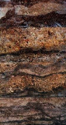
7 Wrightwood 12 meters section 44 clastic layers 15 earthquakes 3000 years Dozens of radiocarbon dates
")
8 Sedimentation Event Return Interval 37 yr Short RI contemporaneous with high sedimentation rates ( high rate/short RI ) Clastic Accumulation Rate (cm/yr) 0.6 cm/yr Cumulative Thickness (cm) Cumulative Frequency 12 yr 2 cm/yr 0.4 cm/yr 236 yr Earthquakes Dated Interpolated Calendar Year (A.D.)
9 Wrightwood Clastic (debris flow) Accumulation Curve
10 Sediment Accumulation Curves
11 Sediment Accumulation Curves


12 Sediment Accumulation Curves


13 WW (cm) Sediment Accumulation Curves
14 Published climate records: Tree rings (drought/wet or hot/cold), correlated to PDO Pollen data (drought/wet) Lake elevations (drought/wet) Glacial advances (cold, wet?) ENSO: higher snow elevations SBB foram records SST Variability (mixing) MWA LIA
15 Drought + hot Drought Cold Wet Really wet Mixed Transition from MWA to LIA coincident with roll over in sedimentation rates Changes in climatic regime coincident with changes in clastic accumulation rate at WW Subdued signal at FM, PC attenuated and less consistent Spike in sed rates (non-eq induced?) during strong ppdo High sed rates during hot drought (w EQs!) Complex signal!

16 Back to the original question: Stratigraphically, timing may be differentiated if we can rely on paleoenvironmental proxies PCT and EL4 occur before a thick soil FM7 occurs after deposition of thick clay, within a soil unit silt soil EL4 silt-sand
17 Distance along SAF A.D. How should we tap into the paleoearthquake records for paleoenvironmental proxy data? How best to systematize this? Who should we go to for funding? No need to invent the wheel!
Holocene droughts, fires, floods and pluvials in southwestern California.
 Holocene droughts, fires, floods and pluvials in southwestern California. Matthew Kirby Professor, Cal-State Fullerton Dept. of Geological Science SCEC SoSAFE Workshop: Recent Successes and Future Challenges
FINAL TECHNICAL REPORT. Award Title Rupture History of the San Andreas Fault in the Carrizo Plain prior to 1300 A.D.
 FINAL TECHNICAL REPORT Award Title Rupture History of the San Andreas Fault in the Carrizo Plain prior to 1300 A.D. Lisa Grant Ludwig Principal Investigator: with Sinan O. Akciz Program in Public Health
SCEC SoSAFE and EQ Geology Geochronology Workshop Report
 SCEC SoSAFE and EQ Geology Geochronology Workshop Report Leaders: Kate Scharer, Ramon Arrowsmith, and Mike Oskin Date: October 28, 2014 Location: Kellogg West Conference Center, Pomona, CA SCEC Award:
Jack Loveless Department of Geosciences Smith College
 Geodetic constraints on fault interactions and stressing rates in southern California Jack Loveless Department of Geosciences Smith College jloveless@smith.edu Brendan Meade Department of Earth & Planetary
PALEOSEISMOLOGY: SITES (17)
") GG 454 February 8, 2002 1 PALEOSEISMOLOGY: SITES (17) Schedule Updates and Reminders: Reading for this lecture: Big Picture - Skim "Applications" in PP 1360 Reading for next lecture: Handouts from Active
GG 454 February 8, 2002 1 PALEOSEISMOLOGY: SITES (17) Schedule Updates and Reminders: Reading for this lecture: Big Picture - Skim "Applications" in PP 1360 Reading for next lecture: Handouts from Active
San Andreas Fault Rupture Scenarios From Multiple
 San Andreas Fault Rupture Scenarios From Multiple Paleoseismic Records: Stringing Pearls Glenn P. Biasi and Ray J. Weldon II Abstract We present a new method to objectively combine paleoseismic event data
Estimating Surface Rupture Length and Magnitude of Paleoearthquakes. From Point Measurements of Rupture Displacement
 Estimating Surface Rupture Length and Magnitude of Paleoearthquakes From Point Measurements of Rupture Displacement Glenn P. Biasi and Ray J. Weldon II August 16, 24 Abstract. We present a method to estimate
to: Interseismic strain accumulation and the earthquake potential on the southern San
 Supplementary material to: Interseismic strain accumulation and the earthquake potential on the southern San Andreas fault system by Yuri Fialko Methods The San Bernardino-Coachella Valley segment of the
Fault Behavior and Characteristic Earthquakes: Examples From the Wasatch and San Andreas Fault Zones
 JOURNAL OF GEOPHYSICAL RESEARCH, VOL. 89, NO. B7, PAGES 5681-5698, JULY IO, 1984 Fault Behavior and Characteristic Earthquakes: Examples From the Wasatch and San Andreas Fault Zones DAVID P. SCHWARTZ AND
Active Tectonics. Earthquakes, Uplift, and Landscape. Edward A. Keller University of California, Santa Barbara
 Prentice Hall Earth Science Series SUB Gottingen 214 80416X, im ^, 2002 A 7883 lllllllilwii Active Tectonics Earthquakes, Uplift, and Landscape Second Edition V Edward A. Keller University of California,
Paleoseismic Event Dating and the Conditional Probability of Large Earthquakes on the Southern San Andreas Fault, California
 Bulletin of the Seismological Society of America, Vol. 92, No. 7, pp. 2761 2781, October 2002 Paleoseismic Event Dating and the Conditional Probability of Large Earthquakes on the Southern San Andreas
The Bridge from Earthquake Geology to Earthquake Seismology
 The Bridge from Earthquake Geology to Earthquake Seismology Computer simulation Earthquake rate Fault slip rate Magnitude distribution Fault geometry Strain rate Paleo-seismology David D. Jackson djackson@g.ucla.edu
Regional Geodesy. Shimon Wdowinski. MARGINS-RCL Workshop Lithospheric Rupture in the Gulf of California Salton Trough Region. University of Miami
 MARGINS-RCL Workshop Lithospheric Rupture in the Gulf of California Salton Trough Region Regional Geodesy Shimon Wdowinski University of Miami Rowena Lohman, Kim Outerbridge, Tom Rockwell, and Gina Schmalze
Description of faults
 GLG310 Structural Geology Description of faults Horizontal stretch Crustal thickness Regional elevation Regional character Issues Normal Thrust/reverse Strike-slip >1 1 in one direction and < 1 in
Earthquake prediction. Southwest BC: Our local dangerous fault zones
 Earthquake prediction Prediction: specifies that an earthquake of a specific magnitude will occur in a defined region during a particular period: There will be a M 7 or larger earthquake in southern California
The SCEC Planning Cycle
 The SCEC Planning Cycle Director Recommends to Agencies (March) Presentation to BoD (February) Leadership Retreat (June) Science Plan Development (Summer) Annual Meeting; Science Plan Input (September)
by G. E. Hilley and J. J. Young Introduction
 Bulletin of the Seismological Society of America, Vol. 98, No. 1, pp. 383 406, February 2008, doi: 10.1785/0120020077 Deducing Paleoearthquake Timing and Recurrence from Paleoseismic Data, Part I: Evaluation
High Resolution Topographic Mapping of Southern California with Optical Imagery. Report for SCEC Award #16147
 High Resolution Topographic Mapping of Southern California with Optical Imagery Report for SCEC Award #16147 Investigators: William Barnhart (University of Iowa) Michael Willis (CU Boulder) Rich Briggs
Stress modulation on the San Andreas fault by interseismic fault system interactions Jack Loveless and Brendan Meade, Geology, 2011
 Stress modulation on the San Andreas fault by interseismic fault system interactions Jack Loveless and Brendan Meade, Geology, 2011 A three step process: 1 - Assimilate plate boundary wide GPS data into
SCEC Earthquake Gates Workshop Central Death Valley Focus Area
 SCEC Earthquake Gates Workshop Central Death Valley Focus Area Fault Gates: Rheology, fault geometry, stress history or directionality? How do we recognize or suspect a fault gate? Paleoseismic or historic
Pure and Applied Geophysics pageoph ISSN Pure Appl. Geophys. DOI /s z
 A 21-Event, 4,000-Year History of Surface Ruptures in the Anza Seismic Gap, San Jacinto Fault, and Implications for Longterm Earthquake Production on a Major Plate Boundary Fault Thomas K. Rockwell, Timothy
Learning goals - January 16, Describe the geometry of a fault (1) orientation of the plane (strike and dip) (2) slip vector
 orientation of the plane (strike and dip) (2) slip vector") Learning goals - January 16, 2012 You will understand how to: Describe the geometry of a fault (1) orientation of the plane (strike and dip) (2) slip vector Understand concept of slip rate and how it is
Learning goals - January 16, 2012 You will understand how to: Describe the geometry of a fault (1) orientation of the plane (strike and dip) (2) slip vector Understand concept of slip rate and how it is
Earthquakes. Earthquake Magnitudes 10/1/2013. Environmental Geology Chapter 8 Earthquakes and Related Phenomena
 Environmental Geology Chapter 8 Earthquakes and Related Phenomena Fall 2013 Northridge 1994 Kobe 1995 Mexico City 1985 China 2008 Earthquakes Earthquake Magnitudes Earthquake Magnitudes Richter Magnitude
San Gorgonio Pass Special Fault Study Area
 San Gorgonio Pass Special Fault Study Area Michele Cooke, David Oglesby and Doug Yule Whitney Behr, Kim Blisniuk, Jim Brune, Sarah Carena, Judi Chester, Gary Fuis, Thomas Goebel, Peter Gold, Egill Hauksson,
Correlation of gravel deposits from trenching project on Alder Creek fluvial terrace near Point Arena, California
 Correlation of gravel deposits from trenching project on Alder Creek fluvial terrace near Point Arena, California Aletha Lee Department of Geology and Geography, West Virginia University, White Hall, Morgantown,
General Geologic Setting and Seismicity of the FHWA Project Site in the New Madrid Seismic Zone
 General Geologic Setting and Seismicity of the FHWA Project Site in the New Madrid Seismic Zone David Hoffman University of Missouri Rolla Natural Hazards Mitigation Institute Civil, Architectural & Environmental
Questions and Topics
 Plate Tectonics and Continental Drift Questions and Topics 1. What are the theories of Plate Tectonics and Continental Drift? 2. What is the evidence that Continents move? 3. What are the forces that
Tectonic geomorphology and earthquake geology of the 1857 reach of the San Andreas Fault: a new look from Airborne Laser Swath Mapping
 2006 SCEC Proposal Tectonic geomorphology and earthquake geology of the 1857 reach of the San Andreas Fault: a new look from Airborne Laser Swath Mapping Principal Investigator: J Ramón Arrowsmith Institution:
Physical Geography A Living Planet
 Physical Geography A Living Planet The geography and structure of the earth are continually being changed by internal forces, like plate tectonics, and external forces, like the weather. Iguaçu Falls at
Overview of the Seismic Source Characterization for the Palo Verde Nuclear Generating Station
 Overview of the Seismic Source Characterization for the Palo Verde Nuclear Generating Station Scott Lindvall SSC TI Team Lead Palo Verde SSC SSHAC Level 3 Project Tuesday, March 19, 2013 1 Questions from
Chapter 2 Planet Earth
 Chapter 2 Planet Earth Section Notes Earth and the Sun s Energy Water on Earth The Land Close-up The Water Cycle World Almanac Major Eruptions in the Ring of Fire Quick Facts Chapter 2 Visual Summary Video
Earthquakes and Faulting
 Earthquakes and Faulting Crustal Strength Profile Quakes happen in the strong, brittle layers Great San Francisco Earthquake April 18, 1906, 5:12 AM Quake lasted about 60 seconds San Francisco was devastated
Earthquake Tectonics and Hazards on the Continents June Recognizing and characterizing strike-slip faults and earthquakes in USA
 2464-4 Earthquake Tectonics and Hazards on the Continents 17-28 June 2013 Recognizing and characterizing strike-slip faults and earthquakes in USA S. G. Wesnousky Univ. of Nevada USA Strike-slip Faults
Fault Specific, Dynamic Rupture Scenarios for Strong Ground Motion Prediction
 Fault Specific, Dynamic Rupture Scenarios for Strong Ground Motion Prediction H. Sekiguchi Disaster Prevention Research Institute, Kyoto University, Japan Blank Line 9 pt Y. Kase Active Fault and Earthquake
An earthquake is the result of a sudden displacement across a fault that releases stresses that have accumulated in the crust of the earth.
 An earthquake is the result of a sudden displacement across a fault that releases stresses that have accumulated in the crust of the earth. Measuring an Earthquake s Size Magnitude and Moment Each can
S. Toda, S. Okada, D. Ishimura, and Y. Niwa International Research Institute of Disaster Science, Tohoku University, Japan
 The first surface-rupturing earthquake in 20 years on a HERP major active fault: Mw=6.2 2014 Nagano, Japan, event along the Itoigawa-Shizuoka Tectonic Line is not characteristic S. Toda, S. Okada, D. Ishimura,
2018 Blue Waters Symposium June 5, Southern California Earthquake Center
 Integrating Physics-based Earthquake Cycle Simulator Models and High-Resolution Ground Motion Simulations into a Physics-based Probabilistic Seismic Hazard Model PI: J. Vidale; Former PI: T. H. Jordan
Mark S. Nordberg Geology and Groundwater Investigations Section North Central Region Office California Department of Water Resources
 Mark S. Nordberg Geology and Groundwater Investigations Section North Central Region Office California Department of Water Resources Ukiah Drought Workshop July 29, 2009 Groundwater 101 Groundwater is
Late Holocene Slip Rate and Ages of Prehistoric Earthquakes along the Maacama Fault Near Willits, Mendocino County, Northern California
 Bulletin of the Seismological Society of America, Vol. 104, No. 6, pp., December 2014, doi: 10.1785/0120140003 E Late Holocene Slip Rate and Ages of Prehistoric Earthquakes along the Maacama Fault Near
Geo736: Seismicity and California s Active Faults Introduction
 Geo736: Seismicity and California s Active Faults Course Notes: S. G. Wesnousky Spring 2018 Introduction California sits on the boundary of the Pacific - North American plate boundary (Figure 1). Relative
A model of the earthquake cycle along the San Andreas Fault System for the past 1000 years
 JOURNAL OF GEOPHYSICAL RESEARCH, VOL. 111,, doi:10.1029/2005jb003703, 2006 A model of the earthquake cycle along the San Andreas Fault System for the past 1000 years Bridget R. Smith and David T. Sandwell
Climate Variability. Eric Salathé. Climate Impacts Group & Department of Atmospheric Sciences University of Washington. Thanks to Nathan Mantua
 Climate Variability Eric Salathé Climate Impacts Group & Department of Atmospheric Sciences University of Washington Thanks to Nathan Mantua Northwest Climate: the mean Factors that influence local/regional
50 or 500? Current Issues in Estimating Fault Rupture Length. David P. Schwartz USGS Menlo Park
 50 or 500? Current Issues in Estimating Fault Rupture Length David P. Schwartz USGS Menlo Park Kondo et al (in press) Rockwell and Okumura (2010) 6.2 5 Hire Tom Rockwell! 4.9 5.1 5.2 4.5 5 4.7 6.1 North
Tsunami potential and modeling
 Tsunami potential and modeling GEORGE PRIEST OREGON DEPT. OF GEOLOGY AND MINERAL INDUSTRIES NEWPORT COASTAL FIELD OFFICE April 7, 2012 GeoPRISMS Cascadia Workshop, Portland, Oregon What creates most uncertainty
Lecture Outlines PowerPoint. Chapter 6 Earth Science 11e Tarbuck/Lutgens
 Lecture Outlines PowerPoint Chapter 6 Earth Science 11e Tarbuck/Lutgens 2006 Pearson Prentice Hall This work is protected by United States copyright laws and is provided solely for the use of instructors
WSWC/NOAA Workshops on S2S Precipitation Forecasting
 WSWC/NOAA Workshops on S2S Precipitation Forecasting San Diego, May 2015 Salt Lake City at NWS Western Region HQ, October 2015 Las Vegas at Colorado River Water Users Association, December 2015 College
GEL 109 Midterm W01, Page points total (1 point per minute is a good pace, but it is good to have time to recheck your answers!
 GEL 109 Midterm W01, Page 1 50 points total (1 point per minute is a good pace, but it is good to have time to recheck your answers!) 1. Where in a water flow is there usually a zone of laminar flow even
Bell Ringer. Are soil and dirt the same material? In your explanation be sure to talk about plants.
 Bell Ringer Are soil and dirt the same material? In your explanation be sure to talk about plants. 5.3 Mass Movements Triggers of Mass Movements The transfer of rock and soil downslope due to gravity is
Historical Changes in Climate
 Historical Changes in Climate Medieval Warm Period (MWP) Little Ice Age (LIA) Lamb, 1969 Hunters in the snow by Pieter Bruegel, 1565 Retreat of the Rhone Glacier shown by comparing the drawing from 1750
Surface Faulting and Deformation Assessment & Mitigation
 Surface Faulting and Deformation Assessment & Mitigation Summary of a Shlemon Specialty Conference sponsored by the Association of Environmental & Engineering Geologists convened on February 19 & 20, 2009
From Earthquakes to Mountains: the Earth s Crust in Motion
 Dean s Freshman Honor Seminar (SCI 110) Eric Calais Associate Professor of Geophysics Purdue University Department of Earth and Atmospheric Sciences ecalais@purdue.edu http:/www.eas.purdue.edu/~calais
Seismic Hazard Assessment of Switzerland, Falko Bethmann October 1 st, 2008
 Seismic Hazard Assessment of Switzerland, 2004 Falko Bethmann October 1 st, 2008 Outline Definition of earthquake sources Definition of seismic recurrence characteristics for each source Ground motion
Earthquake prediction. Earthquake prediction: animals?
 Earthquake prediction Prediction: specifies that an earthquake of a specific magnitude will occur in a defined region during a particular period: There will be a M 7 or larger earthquake in southern California
Yesterday scaling laws. An important one for seismic hazard analysis
 Yesterday scaling laws An important one for seismic hazard analysis Estimating the expected size of an earthquake expected on a fault for which the mapped length is known. Wells & Coppersmith, 1994 And
2018 Weather Outlook, Inversions & Managing of Weather Risk Using GDD. Elwynn Taylor
 2018 Weather Outlook, Inversions & Managing of Weather Risk Using GDD Elwynn Taylor setaylor@iastate.edu Garden of the Gods & Pike s Peak Frost sensitive fruit trees on upland slope Temperature Inversions
STUDENT NAME. Science Grade 5. Read each question and choose the best answer. Be sure to mark all of your answers.
 FORMATIVE MINI ASSESSMENTS First Grading Period 2010-11 September 21-24 STUDENT NAME DATE Science Grade 5 Read each question and choose the best answer. Be sure to mark all of your answers. 1 Which is
Physical Geology, 15/e
 Lecture Outlines Physical Geology, 15/e Plummer, Carlson & Hammersley Deserts & Wind Action Physical Geology 15/e, Chapter 13 Deserts Desert any arid region that receives less than 25 cm of precipitation
Stream Channel Offset and Late Holocene Slip Rate of the San Andreas Fault at the Van Matre Ranch Site, Carrizo Plain, California
 Bulletin of the Seismological Society of America, Vol. 96, No. 1, pp. 33 47, February 2006, doi: 10.1785/0120050094 Stream Channel Offset and Late Holocene Slip Rate of the San Andreas Fault at the Van
Irregular recurrence of paleoearthquakes along the central Garlock fault near El Paso Peaks, California
 JOURNAL OF GEOPHYSICAL RESEARCH, VOL. 108, NO., B7 2356, doi:10.1029/2001jb001744, 2003 Irregular recurrence of paleoearthquakes along the central Garlock fault near El Paso Peaks, California Timothy E.
by George E. Hilley, J Ramón Arrowsmith, and Elizabeth Stone Introduction
 Bulletin of the Seismological Society of America, 91, 3, pp. 427 440, June 2001 Inferring Segment Strength Contrasts and Boundaries along Low-Friction Faults Using Surface Offset Data, with an Example
Mass Movements, Wind, and Glaciers
 Mass Movements,, and Glaciers SECTION 8.1 Mass Movement at Earth s Surface In your textbook, read about mass movement. Use each of the terms below just once to complete the passage. avalanche creep landslide
Presentation Overview. Southwestern Climate: Past, present and future. Global Energy Balance. What is climate?
 Southwestern Climate: Past, present and future Mike Crimmins Climate Science Extension Specialist Dept. of Soil, Water, & Env. Science & Arizona Cooperative Extension The University of Arizona Presentation
I. Locations of Earthquakes. Announcements. Earthquakes Ch. 5. video Northridge, California earthquake, lecture on Chapter 5 Earthquakes!
 51-100-21 Environmental Geology Summer 2006 Tuesday & Thursday 6-9:20 p.m. Dr. Beyer Earthquakes Ch. 5 I. Locations of Earthquakes II. Earthquake Processes III. Effects of Earthquakes IV. Earthquake Risk
STUDY GUIDE FOR MID-TERM EXAM KEY. Color, luster, cleavage, fracture, hardness, taste, smell, fluorescence, radioactivity, magnetism
 STUDY GUIDE FOR MID-TERM EXAM KEY 1. In which type of rock are fossils most likely to be found? Sedimentary Rocks 2. Which mineral is easily identified by smell? Sulfur 3. Which natural resource makes
Kinematics of the Southern California Fault System Constrained by GPS Measurements
 Title Page Kinematics of the Southern California Fault System Constrained by GPS Measurements Brendan Meade and Bradford Hager Three basic questions Large historical earthquakes One basic question How
Plate Boundary Observatory Working Group Plan for the San Andreas Fault System
 Introduction Plate Boundary Observatory Working Group Plan for the San Andreas Fault System This document puts forward a draft implementation plan for the San Andreas Fault component of the Plate Boundary
mountain rivers fixed channel boundaries (bedrock banks and bed) high transport capacity low storage input output
 high transport capacity low storage input output") mountain rivers fixed channel boundaries (bedrock banks and bed) high transport capacity low storage input output strong interaction between streams & hillslopes Sediment Budgets for Mountain Rivers Little
mountain rivers fixed channel boundaries (bedrock banks and bed) high transport capacity low storage input output strong interaction between streams & hillslopes Sediment Budgets for Mountain Rivers Little
Today: Basic regional framework. Western U.S. setting Eastern California Shear Zone (ECSZ) 1992 Landers EQ 1999 Hector Mine EQ Fault structure
 1992 Landers EQ 1999 Hector Mine EQ Fault structure") Today: Basic regional framework Western U.S. setting Eastern California Shear Zone (ECSZ) 1992 Landers EQ 1999 Hector Mine EQ Fault structure 1 2 Mojave and Southern Basin and Range - distribution of strike-slip
Today: Basic regional framework Western U.S. setting Eastern California Shear Zone (ECSZ) 1992 Landers EQ 1999 Hector Mine EQ Fault structure 1 2 Mojave and Southern Basin and Range - distribution of strike-slip
Scientific Research on the Cascadia Subduction Zone that Will Help Improve Seismic Hazard Maps, Building Codes, and Other Risk-Mitigation Measures
 Scientific Research on the Cascadia Subduction Zone that Will Help Improve Seismic Hazard Maps, Building Codes, and Other Risk-Mitigation Measures Art Frankel U.S. Geological Survey Seattle, WA GeoPrisms-Earthscope
Estimating fault slip rates, locking distribution, elastic/viscous properites of lithosphere/asthenosphere. Kaj M. Johnson Indiana University
 3D Viscoelastic Earthquake Cycle Models Estimating fault slip rates, locking distribution, elastic/viscous properites of lithosphere/asthenosphere Kaj M. Johnson Indiana University In collaboration with:
Initiation of the San Jacinto Fault and its Interaction with the San Andreas Fault: Insights from Geodynamic Modeling
 Pure appl. geophys. (2007) DOI 10.1007/s00024-007-0262-z Ó Birkhäuser Verlag, Basel, 2007 Pure and Applied Geophysics Initiation of the San Jacinto Fault and its Interaction with the San Andreas Fault:
Slip on faults in the Imperial Valley triggered by the 4 April 2010 Mw 7.2 El Mayor Cucapah earthquake revealed by InSAR
 GEOPHYSICAL RESEARCH LETTERS, VOL. 38,, doi:10.1029/2010gl045235, 2011 Slip on faults in the Imperial Valley triggered by the 4 April 2010 Mw 7.2 El Mayor Cucapah earthquake revealed by InSAR Meng Wei,
Long-Term Paleoseismology in Cascadia: Probabilities, Clustering, and patterns of Energy Release
 Long-Term Paleoseismology in Cascadia: Probabilities, Clustering, and patterns of Energy Release Chris Goldfinger College of Earth, Ocean and Atmospheric Sciences, Oregon State University Active Tectonics
Variations in Tremor Activity and Implications for Lower Crustal Deformation Along the Central San Andreas Fault
 Variations in Tremor Activity and Implications for Lower Crustal Deformation Along the Central San Andreas Fault David R. Shelly USGS, Menlo Park Shelly and Hardebeck, GRL, 2010 Collaborators: Jeanne Hardebeck
2013 SCEC Annual Report
 2013 SCEC Annual Report Collaborative research: Documentation of Tsunami Deposits in the Carpinteria Estuary: A signal of Great Earthquakes on the Pitas Point Thrust L. Reynolds, A. Simms, T.K. Rockwell,
Constraints from precariously balanced rocks on preferred rupture directions for large earthquakes on the southern San Andreas Fault
 DOI 10.1007/s10950-007-9078-7 ORIGINAL ARTICLE Constraints from precariously balanced rocks on preferred rupture directions for large earthquakes on the southern San Andreas Fault Kim Olsen & James Brune
Figure 1 The map shows the top view of a meandering stream as it enters a lake. At which points along the stream are erosion and deposition dominant?
 1. In which type of climate does chemical weathering usually occur most rapidly? 1. hot and dry 3. cold and dry 2. hot and wet 4. cold and wet 2. Figure 1 The map shows the top view of a meandering stream
PROBABILISTIC SURFACE FAULT DISPLACEMENT HAZARD ANALYSIS (PFDHA) DATA FOR STRIKE SLIP FAULTS
 DATA FOR STRIKE SLIP FAULTS") PROBABILISTIC SURFACE FAULT DISPLACEMENT HAZARD ANALYSIS (PFDHA) DATA FOR STRIKE SLIP FAULTS PEER SURFACE FAULT DISPLACEMENT HAZARD WORKSHOP U.C. Berkeley May 20-21, 2009 Timothy Dawson California Geological
PROBABILISTIC SURFACE FAULT DISPLACEMENT HAZARD ANALYSIS (PFDHA) DATA FOR STRIKE SLIP FAULTS PEER SURFACE FAULT DISPLACEMENT HAZARD WORKSHOP U.C. Berkeley May 20-21, 2009 Timothy Dawson California Geological
Weather and Climate Summary and Forecast January 2018 Report
 Weather and Climate Summary and Forecast January 2018 Report Gregory V. Jones Linfield College January 5, 2018 Summary: A persistent ridge of high pressure over the west in December produced strong inversions
AN APPROACH TO THE CLASSIFICATION OF SLOPE MOVEMENTS
 Training/workshop on Earthquake Vulnerability and Multi-Hazard Risk Assessment: Geospatial Tools for Rehabilitation and Reconstruction Effort 13 31 March 2006, Islamabad, Pakistan AN APPROACH TO THE CLASSIFICATION
STRUCTURE AND HOLOCENE SLIP OF THE JID FAULT, MONGOLIA ALTAI
 STRUCTURE AND HOLOCENE SLIP OF THE JID FAULT, MONGOLIA ALTAI LAURA K.O. SMITH AND SARAHTSETSEG PUREDORG Princeton University, Mongolian University of Science and Technology Sponsors: Ramon Gonzalez-Mieres
MASS MOVEMENTS, WIND, AND GLACIERS
 Date Period Name MASS MOVEMENTS, WIND, AND GLACIERS SECTION.1 Mass Movements In your textbook, read about mass movements. Use each of the terms below just once to complete the passage. avalanche creep
USU 1360 TECTONICS / PROCESSES
 USU 1360 TECTONICS / PROCESSES Observe the world map and each enlargement Pacific Northwest Tibet South America Japan 03.00.a1 South Atlantic Arabian Peninsula Observe features near the Pacific Northwest
2 June 15. Summer Session Horst Rademacher. Lect 3: California EQ. and Faults.
 2 June 15 2 Summer Session 2015 Horst Rademacher HH Lect 3: California EQ and Faults http://seismo.berkeley.edu/summersession/eps20/ Class Organization Website: You need to sign up for class announcements!
The 1700/01/26 Cascadia subduction zone Earthquake and Tsunami
 Jason R. Patton GEO 142 1/13/15 Abstract: Cascadia subduction zone earthquakes (CSZ) can generate strong ground shaking and deadly tsunamis. Geologists used sediment cores and stream bank exposures to
Rocks and the Rock Cycle. Banded Iron Formation
 Rocks and the Rock Cycle Banded Iron Formation Rocks Big rocks into pebbles, Pebbles into sand. I really hold a million, million Rocks here in my hand. Florence Parry Heide How do rocks change? How are
Southern California Earthquake Center. SCEC Annual Meeting. Palm Springs, California September 2016
 SCEC Annual Meeting Palm Springs, California 11-14 September 2016 Welcome to Palm Springs! Southern California SCEC Annual Meetings 707 pre-registrants 347 poster abstracts 211 first-time attendees (145
Integrating Geologic and Geodetic Estimates of Slip Rate on the San Andreas Fault System
 International Geology Review, Vol. 44, 2002, p. 62 82. Copyright 2002 by V. H. Winston & Son, Inc. All rights reserved. Integrating Geologic and Geodetic Estimates of Slip Rate on the San Andreas Fault
SUPPLEMENTARY INFORMATION
 Loading of the San Andreas fault by flood-induced rupture of faults beneath the Salton Sea Daniel Brothers, Debi Kilb, Karen Luttrell, Neal Driscoll and Graham Kent Figure S1. Location map for profiles
The Seismogenic Thickness of the Southern California Crust
 Bulletin of the Seismological Society of America, Vol. 94, No. 3, pp. 940 960, June 2004 The Seismogenic Thickness of the Southern California Crust by Julie J. Nazareth and Egill Hauksson Abstract The
Landslides and Ground Water Permeability with Respect to the. Contact Point of Glacial Lake Vermont and the Champlain Sea
 Landslides and Ground Water Permeability with Respect to the Contact Point of Glacial Lake Vermont and the Champlain Sea Sediments at Town Line Brook, Winooski, VT Michala Peabody Lara Vowles Abstract:
1. Erosion by Running Water Most powerful cause of erosion
 I. Destructive Forces Notes: Destructive force: a process in which land is destroyed or changed such as weathering and erosion. All landforms are a result of a combination of constructive and destructive
HIGH-RESOLUTION AIRBORNE LIDAR/CCD MAPPING OF SAN ANDREAS FAULT
 HIGH-RESOLUTION AIRBORNE LIDAR/CCD MAPPING OF SAN ANDREAS FAULT Charles Toth, Dorota A. Grejner-Brzezinska and Michael Bevis The Center for Mapping Satellite Positioning and Inertial Navigation (SPIN)
Using the WHOI CMIP5 archive to understand paleoclimate dynamics
 Using the WHOI CMIP5 archive to understand paleoclimate dynamics Kevin Anchukaitis Department of Geology and Geophysics Laura Fleming Northeastern University [B.Sc. Physics (Maths) 214] Using the WHOI
Slip rates and off-fault deformation in Southern California inferred from GPS data and models
 JOURNAL OF GEOPHYSICAL RESEARCH: SOLID EARTH, VOL. 8, 6 66, doi:./jgrb.6, Slip rates and off-fault deformation in Southern California inferred from GPS data and models K. M. Johnson Received 9 December
THE ACTION OF GLACIERS
 Surface processes THE ACTION OF GLACIERS Glaciers are enormous masses of ice which are formed due to accumulation, compaction and re-crystallisation of the snow deposited in very cold regions (the majority
Chapter 5: Glaciers and Deserts
 I. Glaciers and Glaciation Chapter 5: Glaciers and Deserts A. A thick mass of ice that forms over land from the compaction and recrystallization of snow and shows evidence of past or present flow B. Types
Chapter 1. Introduction and Synthesis
 Chapter 1 Introduction and Synthesis 1-2 Motivation: inadequacy of data for understanding earthquake cycles Understanding the behavior of active faults over multiple seismic cycles has been an elusive
Introduction to Quaternary Geology (MA-Modul 3223) Prof. C. Breitkreuz, SS2012, TU Freiberg
 Prof. C. Breitkreuz, SS2012, TU Freiberg") Introduction to Quaternary Geology (MA-Modul 3223) Prof. C. Breitkreuz, SS2012, TU Freiberg 1. Introduction: - Relevance, and relations to other fields of geoscience - Lower stratigraphic boundary and
Introduction to Quaternary Geology (MA-Modul 3223) Prof. C. Breitkreuz, SS2012, TU Freiberg 1. Introduction: - Relevance, and relations to other fields of geoscience - Lower stratigraphic boundary and
RECENT COMPREHENSIVE TSUNAMI MODELING FOR COASTAL OREGON
 RECENT COMPREHENSIVE TSUNAMI MODELING FOR COASTAL OREGON Speaker: George R. Priest, Oregon Dept. of Geology and Mineral Industries Pardee Keynote Symposium Great Earthquakes, the Cascadia Subduction Zone,