GODIŠNJE IZVJEŠĆE ANNUAL REPORT
|
|
|
- Paul Jordan
- 5 years ago
- Views:
Transcription


1 GODIŠNJE IZVJEŠĆE ANNUAL REPORT 2011
2 NAKLADNIK PUBLISHER Hrvatski geološki institut Croatian Geological Survey Sachsova 2, HR Zagreb, Hrvatska (Croatia) ZA NAKLADNIKA FOR THE PUBLISHER UREDNIK EDITOR TEHNIČKO UREÐIVANJE TECHNICAL EDITING UREDNIČKI ODBOR EDITORIAL BOARD PRIJEVOD NA ENGLESKI JEZIK ENGLISH TRANSLATION LEKTURA ENGLESKOGA JEZIKA ENGLISH LANGUAGE EDITING REALIZACIJA REALIZATION NAKLADA EDITION Ravnatelj (Director) Josip HALAMIĆ Josip TERZIĆ za LASERplus d.o.o. Snježana ENGELMAN DŽAFIĆ Željka BRKIĆ Renato BULJAN Tea FLUKSI Josip HALAMIĆ Ivan HEĆIMOVIĆ Marija HORVAT Domagoj JAMIČIĆ Tvrtko KORBAR Miron KOVAČIĆ Ozren LARVA Slobodan MIKO Zoran PEH Damir SLOVENEC Marko ŠPARICA Zoran PEH Online: Elsevier Language Editing LASERplus d.o.o. 300 primjeraka (copies) ISSN X
3 Sadržaj / Content Uvodnik / Introduction 2 HGI: organizacija, brojke i činjenice / CGS: Organisation, Numbers and Facts 7 Organizacijska struktura, zaposlenici i proračun / Organizational Scheme, Employees and Budget 8 Internetska stranica Hrvatskog geološkog instituta / The Website of the Croatian Geological Survey 10 Zavod za geologiju / Department of Geology 12 Zavod za hidrogeologiju i inženjersku geologiju / Department of Hydrogeology and Engineering Geology 16 Zavod za mineralne sirovine / Department of Mineral Resources 20 Geološka služba / Geological Survey 24 Geološke karte temeljna djelatnost / Geological Maps Basic Activity 29 Osnovna geološka karta Republike Hrvatske 1: / Basic Geological Map of the Republic of Croatia 1:50, Osnovna inženjerskogeološka karta Republike Hrvatske 1: / Basic Engineering Geological Map of the Republic of Croatia 1:100, Osnovna hidrogeološka karta Republike Hrvatske 1: / Basic Hydrogeological Map of the Republic of Croatia 1:100, Osnovna geokemijska karta Republike Hrvatske / Basic Geochemical Map of the Republic of Croatia 38 Karta mineralnih sirovina Republike Hrvatske / Map of the Mineral Resources of the Republic of Croatia 41 Geotermalna karta Republike Hrvatske / Geothermal Map of the Republic of Croatia 44 Tektonska karta Republike Hrvatske 1: / Tectonic Map of the Republic of Croatia 1:300, Strukturno-geomorfološka karta Republike Hrvatske 1: / Structural-Geomorphological Map of the Republic of Croatia 1:100, Odabrani projekti / Selected Projects 51 Stratigrafija naslaga krede u okviru geodinamike jadranskog područja Hrvatske / Stratigraphy and Geodynamic Context of Cretaceous Deposits in the Northeastern Adriatic Region 52 Hidrogeološka istraživanja na području crpilišta Zapadno polje u Požegi / Hydrogeological Investigations in the Zapadno polje Groundwater Source Area in Požega 54 SARMa: Održivo gospodarenje kamenim agregatima / Sustainable Aggregates Resource Management 56 Organski ugljik u tlima Hrvatske SOC Hrvatska / Total Organic Carbon (TOC) in Croatian Soils 58 Most Kopno Pelješac / The Bridge from the Mainland to the Pelješac Peninsula 60 Mezozojske magmatske, plaštne i piroklastične stijene sjeverozapadne Hrvatske / Mesozoic Igneous, Mantle, and Pyroclastic Rocks of Northwestern Croatia 62 CC-WaterS: Klimatske promjene i utjecaj na vodoopskrbu / Climate Change and Impacts on Water Supply 65 Publikacije / Publications 69 Knjižnica Hrvatskog geološkog instituta / Library of the HGI-CGS 70 Znanstveni časopis Geologia Croatica / Scientific Journal Geologia Croatica 72 Bibliografija djelatnika HGI-CGS-a u godini / Bibliography of HGI-CGS Staff in Studije i elaborati / Studies and Elaborates 78
![uvodnik Uvodnik Introduction Prof. dr. sc. Josip HALAMIĆ Ravnatelj / Director josip.halamic@hgi-cgs.hr GODI[NJE IZVJE[]E 2011.](/docs-images/85/92396104/images/4-0.jpg "Pred Vama je još jedno godišnje izviješće u kojem Vas želimo informirati o radu naše ustanove tijekom 2011. godine.")
4 uvodnik Uvodnik Introduction Prof. dr. sc. Josip HALAMIĆ Ravnatelj / Director josip.halamic@hgi-cgs.hr GODI[NJE IZVJE[]E Pred Vama je još jedno godišnje izviješće u kojem Vas želimo informirati o radu naše ustanove tijekom godine. Osim temeljnih informacija o Institutu, u prilozima su dane informacije o radu na temeljnim znanstveno-istraživačkim projektima, međunarodnim projektima, projektima za gospodarstvo te na polju znanstveno-publicističke djelatnosti. Ja ću se u uvodnom dijelu usredotočiti samo na one događaje koji su bili od značaja za buduće aktivnosti, odnosno koji će utjecati na pravac našeg daljnjeg razvoja. * Agencija za znanost i visoko obrazovanje (AZVO) je godine pokrenula reakreditacijski postupak za sve znanstvene institute u Republici Hrvatskoj, zbog čega je izrađena Samoanaliza Hrvatskog geološkog instituta, kao polazišna osnova za evaluaciju. Tematska evaluacija provedena je 31. svibnja godine, od strane međunarodnog povjerenstva sastavljenog od tri eksperta iz područja geoznanosti: prof. dr. Donald Bruce Dingwell (Sveučilište München, Njemačka), dr. Aristomenis Karageorgis (Hellenic Organisation for Marine Research, Grčka) i dr. Antonio Cruzado (Oceans Catalonia International, Španjolska). Smatram kako je provođenje tematske evaluacije s prethodnom samoanalizom od velike koristi, ne samo za Institut, nego i za nadležno Ministarstvo. Tim dokumentima utvrđeno je realno stanje, kako u organizaciji Instituta, tako i u području znanstvene djelatnosti njenih istraživača, te je ukazano na one korake koje je potrebno učiniti sa ciljem poboljšanja dosadašnje aktivnosti HGI-CGS-a u području geoznanosti. Radi važnosti te materije na ovom mjestu ću navesti neka ključna zapa- You are hereby presented with another annual report in which we intend to inform you about the work and activities of our institution during In addition to the essential details about the Survey, the chapters provide information about scientific research projects, international projects, commercial projects and information on the Survey s scientific publishing. In this introductory section, I shall focus solely on those particular events that will play a significant role in the scope of our future activities, that is, those events that will pave the way for our further development. * In 2010, the Agency for Science and Higher Education Croatia (AZVO) initiated reaccreditation procedures that included all scientific institutes in the Republic of Croatia. For this reason, we have prepared the document Self-analysis of Croatian Geological Survey as the starting point for an evaluation procedure. A thematic evaluation was performed on May 31 st, 2011, by an international committee composed of three experts from the field of geosciences: Prof. Dr. Donald Bruce Dingwell (University of Munich, Germany), Dr. Aristomenis Karageorgis (Hellenic Organization for Marine Research, Greece) and Dr. Antonio Cruzado (Oceans Catalonia International, Spain). I hold the opinion that thematic evaluation together with preliminary self-analysis is of great assistance not only to our Survey but also to the responsible Ministry. That document defines the de facto situation both in the organisation of the Survey and in the scientific activity of its researchers, and it indicates the necessary steps to ameliorate the former activities of HGI-CGS in the field of geosciences. Taking into consideration the significance of this matter, I shall only refer to some crucial objections and sug- 2 HRVATSKI GEOLOŠKI INSTITUT

5 žanja i sugestije koje su članovi povjerenstva naveli u svojoj ocjeni evaluacije te očitovanje Uprave HGI-CGS-a na te zaključke. Povjerenstvo je u poglavlju misija, vizija i težište znanstvene djelatnosti ukazalo na nedostatak vrjednovanja rada Instituta kroz izradu geoloških karata od strane nadležnog ministarstva, pošto se sveukupni rad za sada procjenjuje samo na temelju publiciranih znanstvenih radova, iako je temeljna djelatnost Instituta izrada geoloških karata na znanstvenim principima. Uprava HGI-CGS-a se u potpunosti slaže s mišljenjem Povjerenstva kako izrada geoloških karata nije samo rutinsko prikupljanje podataka, nego rad koji potiče intenzivnu znanstvenu aktivnost. Stoga uprava podržava prijedlog prema kojem bi država trebala dati dobro definiranu podršku, i to kroz posebne ugovore koji bi uključivali i trajanje izrade pojedinih listova geoloških karata, kadrove i rezultate istraživanja. Naglašeno je kako na taj način funkcioniraju mnoge geološke službe u svijetu. Analizirajući suradnju HGI-CGS-a s drugim znanstveno-istraživačkim institucijama povjerenstvo je dalo preporuku za intenziviranje međunarodne suradnje. U posljednjih godinu dana primjetan je rast takvog angažmana naših znanstvenika te Instituta u cjelini, što je pospješeno, osim ostalog, intenzivnijom podrškom nadležnih državnih tijela. Učlanjivanjem HGI- CGS-a u konzorcij EuroGeoSurveys (2006. godine) željeli smo postići da Institut, kao Hrvatska geološka služba, bude prepoznat kao ravnopravni partner u Europskoj Uniji te da izravno gestions that the members of the committee mentioned in their final assessment as well as the statement of the HGI-CGS Governing Board on their final decision. In the chapter Mission, Vision and Focus of the Scientific Research, the committee pointed out the absence of an evaluation of the Survey s activity based on the development of geological maps. This absence is a matter of concern for the responsible Ministry, as the sum total of our activity is currently appraised solely through scientific publishing, disregarding that the Survey s basic activity is represented by the development of geological maps on scientific grounds. The HGI-CGS Governing Board is in complete agreement with the Committee s opinion that the development of geological maps entails not only the routine collection of data but also work fostering intense scientific activity. For this reason, the Board supports the recommendation that the national authorities provide well-defined support, particularly through the special agreements, which include the time of completion of single sheets of geological maps, the staff employed, and the results of the investigation. It is stressed that this is the way many geological surveys in the world are conducted. Through analysing the cooperation activities of HGI-CGS with other science-research institutes the Committee, an intensification of international collaboration is recommended. During the last year, such engagement involving our individual researchers and the Survey as a whole was quite noticeably enhanced, among other things, by the more vigorous assistance of responsible governmental bodies. By enrolling HGI-CGS in the EuroGeo- INTRODUCTION Članovi međunarodnog povjerenstva za tematsku evaluaciju (drugi s lijeva: dr. Aristomenis Karageorgis; treći s lijeva: prof. dr. Donald Bruce Dingwell i četvrti s lijeva: dr. Antonio Cruzado). Members of the International Committee for thematic evaluation (second from left: Dr. Aristomenis Karageorgis; third left: Prof. Dr. Donald Bruce Dingwell, and fourth left: Dr. Antonio Cruzado). ANNUAL REPORT 2011 CROATIAN GEOLOGICAL SURVEY 3


6 Razgovor s predstavnicima znanstvenih institucija i gospodarskih tvrtki s kojima HGI ima suradnju. uvodnik Intervju znanstvenih novaka HGI-a. Interview with the junior researchers of HGI-CGS. Conversation with representatives of the scientific institutions and the economic sector in cooperation with HGI-CGS. GODI[NJE IZVJE[]E sudjeluje i u izvođenju raznovrsnih projekata na razini Europe. U strategiji HGI-CGS-a, čija izrada je u tijeku, u narednom periodu ćemo posvetiti veliku pažnju intenzivnijoj međunarodnoj suradnji, kako kroz sudjelovanje u raznovrsnim projektima, tako i kroz razmjenu mladih znanstvenika (doktoranti, postdoktoranti) s drugim srodnim institucijama u inozemstvu. U analizi rezultata rada u potpunosti se slažemo s preporukom Povjerenstva kako bi temeljna djelatnost HGI-a trebala biti jasno i izričito regulirana u novom zakonskom okviru. Osim toga, podržavamo i konstataciju kako bi i nastavna aktivnost znanstvenika HGI-CGS-a, kao profesora predavača, trebala bi- Surveys consortium (2006), our intention was that the Institute, such as the Croatian Geological Survey, would be recognised as an equal partner in the European Union and would directly participate in various projects at the European level. In the strategy document, currently under development, we shall devote great attention in the forthcoming period to more dynamic international cooperation, both through participation in the assorted projects and through the secondment of young scientists (doctorands and post doctorands) to related institutions abroad. With regard to the analysis of our activities, we will fully comply with the Committee s recommendation that the basic activity of 4 HRVATSKI GEOLOŠKI INSTITUT

7 ti adekvatno valorizirana i znanstveno nagrađena. Smatramo kako je transfer praktičnog znanja od Instituta prema Sveučilištu od iznimnog značaja za izobrazbu kadrova koji se kasnije zapošljavaju u gospodarstvu ili u raznovrsnim srodnim institucijama, te u privatnim kompanijama. Unatoč značajnom broju znanstvenih radova postoje problemi koji su uvjetovani definiranom temeljnom djelatnošću HGI-CGS-a. Naime, autorske geološke karte i prateći tumači u vidu monografija nisu vrjednovani kao znanstvene publikacije. Bez obzira što su te karte regionalnog karaktera, one čine znatan doprinos znanosti na nacionalnom nivou (a da ne spominjemo njihovu gospodarstvenu vrijednost podzemna voda, mineralne sirovine, zaštita okoliša i dr.). Osim temeljne znanstvene djelatnosti HGI-CGS ima i savjetodavnu ulogu obrazovnih institucija (sveučilište, srednje škole, osnovne škole), privatnog sektora, javne administracije i javnosti općenito. * Krajem godine završen je petogodišnji ciklus znanstvenoistraživačkih projekata financiranih od strane Ministarstva znanosti, obrazovanja i sporta. Kako novi zakon o znanosti nije donesen, tako je neizvjesno na koji način će se ugovarati projekti u novom ciklusu. Predviđa se ugovaranje putem Programskih ugovora uz financiranje znanstvenih projekata putem Hrvatske zaklade za znanost (HRZZ). Stoga će glavna zadaća Uprave HGI-CGS-a početkom sljedeće godine biti intenzivan rad na donošenju kratkoročne i dugoročne strategije, kako bismo mogli na vrijeme odgovoriti na sve potrebe novog načina prijavljivanja znanstvenih projekata. Osim toga strategija mora biti u skladu s novim ciklusom Europskih projekata HORIZON * Nadam se kako ćemo Vam kroz priloge u ovom izviješću približiti rad i zainteresirati Vas za djelatnost i rezultate znanstvenog rada naše institucije. our Survey should be clearly and explicitly regulated within the new statutory framework. Moreover, we uphold the conclusion that the teaching activity of the HGI-CGS scientific staff, as the lecturer professors, should be adequately appraised and scientifically rewarded (because it is not the basic activity of the Survey). We assume that the knowledge transfer direction from Survey to University is of exceptional importance for the education of staff who will be employed later, either in the economic sector or in various similar institutions, and in private companies. Despite the significant number of peer-reviewed papers, there are still problems arising from the undefined basic activity of the Survey, namely that the authorised geological maps and supplementary explanations published as monographs are not evaluated as scientific publications. Regardless of their regional character, these maps make a considerable contribution at the national level (not to mention their value in the state economy potable underground water, mineral resources, protection of the environment, etc.). In addition to its scientific activity, HGI-CGS also features the inherent counselling role characteristic of educational institutions (university, secondary schools, and elementary schools), the private sector, public administration and the public in general. * Late last year, the five-year cycle of the scientific research projects funded by the Ministry of Science, Education and Sports was closed. Because the new Science Act has not yet been enacted, the mode of project contracting in the new period is still precarious. Contracting through the Performance Agreement is expected, accompanied by the involvement of the Croatian Science Foundation (HRZZ) in the science project funding. For this reason, the main task of the HGI-CGS Governing Board at the beginning of next year will be to focus strongly on the adoption of shortterm and long-term strategies whose purpose will be to react in a timely manner to all demands brought by the new mode of science project notifications. Moreover, the strategy document must be attuned with the new cycle of European projects called HORIZON 2020 * I hope that this report will succeed in drawing your attention to our work through various supplementary materials and that you will find the activities and results of our Survey intriguing. ANNUAL REPORT 2011 INTRODUCTION CROATIAN GEOLOGICAL SURVEY 5
![GODI[NJE IZVJE[]E 2011.](/docs-images/85/92396104/images/8-0.jpg "HGI: organizacija, brojke i činjenice 6")
8 GODI[NJE IZVJE[]E HGI: organizacija, brojke i činjenice 6 HRVATSKI GEOLOŠKI INSTITUT


9 CGS: organisation, numbers and facts HGI: organizacija, brojke i činjenice / CGS: Organisation, Numbers and Facts ANNUAL REPORT 2011 CROATIAN GEOLOGICAL SURVEY 7
10 HGI: organizacija, brojke i činjenice Organizacijska struktura, zaposlenici i proračun Organizational Scheme, Employees and Budget RAVNATELJ DIRECTOR: Prof. dr. sc. Josip HALAMIĆ tel: (+385 1) fax: (+385 1) josip.halamic@hgi-cgs.hr Zamjenica ravnatelja Director deputy: Dr. sc. Željka BRKIĆ Pomoćnici ravnatelja Director assistants: za ekonomsko-financijske poslove Slobodan DUKOVČIĆ, dipl.oec. for economic-financial business za koordinaciju poslovanja s tržištem Dr. sc. Saša MESIĆ for coordination of business with the market tajnica Instituta Mladenka JURČIĆ, dipl.iur. Secretary of the HGI-CGS UPRAVNO VIJEĆE GOVERNING BOARD Prof. dr. sc. Dražen VIKIĆ TOPIĆ (MZOŠ*), predsjednik Chairman Dr. sc. Dragan KRASIĆ (MGRP*) Prof. dr. sc. Milan ORŠANIĆ (ŠF*) Dr. sc. Renato BULJAN (HGI-CGS) Dr. sc. Marija HORVAT (HGI-CGS) GODI[NJE IZVJE[]E ZNANSTVENO VIJEĆE SCIENTIFIC COUNCIL Dr.sc. Mirko BELAK Dr. sc. Željka BRKIĆ Mihovil BRLEK Dr. sc. Renato BULJAN, zamjenik predsjednika Chairman deputy Dr. sc. Lidija GALOVIĆ Dr. sc. Tonči GRGASOVIĆ, predsjednik Chairman Dr. sc. Valentina HAJEK-TADESSE Prof. dr. sc. Josip HALAMIĆ Dr. sc. Ivan HEĆIMOVIĆ Nikolina ILIJANIĆ tajnica Secretary Dr. sc. Domagoj JAMIČIĆ Dr. sc. Georg KOCH Dr. sc. Tvrtko KORBAR Dr. sc. Miron KOVAČIĆ Dr.sc. Tamara MARKOVIĆ, tajnica Secretary Dr. sc. Dubravko MATIČEC Dr.sc. Saša MESIĆ Dr. sc. Slobodan MIKO Dr. sc. Zoran PEH Dr. sc. Damir SLOVENEC Dr. sc. Andrej STROJ Dr. sc. Josip TERZIĆ *MZOŠ Ministry of Science, Education and Sports of the Republic of Croatia *MGRP Ministry of Economy, Labour, and Entrepreneurship *ŠF Faculty of Forestry, University of Zagreb, Croatia 8 HRVATSKI GEOLOŠKI INSTITUT


11 zaposlenika po Zavodima 111 of emloyees per departments CGS: organisation, numbers and facts 10 Ured ravnatelja Director's Office 5 0 Zavod za geologiju Department of Geology Zavod za mineralne sirovine Department of Mineral Resources Zavod za geologiju Department of Geology Zavod za hidrogeologiju i inženjersku geologiju Department of Hydrogeology and Engineering Geology Zavod za hidrogeologiju i inženjersku geologiju Department of Hydrogeology and Engineering Geology Stručne službe Administration and technical support 17 Zaposlenici po Zavodima Emloyees per departments Zavod za mineralne sirovine Department of Mineral Resources Geološka služba Geological Survey Arhiva Geolis Knjižnica Archive Geolis Library Dr.sc./Ph.D. Mr.sc./M.Sc. dipl.ing./b.sc. ostali/others mil. kn 30 Prihodi HGI-CGS Budget of HGI-CGS Stručne službe Administration and technical support CROATIAN GEOLOGICAL SURVEY 9 Zavod za geologiju Department of Geology Zavod za hidrogeologiju i inženjersku geologiju Department of Hydrogeology and Engineering Geology Zavod za mineralne sirovine Department of Mineral Resources Geološka služba Geological survey Geologia Croatica Stručne službe Administration and technical support Geološki kongres Geological congres Sveukupno Total ANNUAL REPORT 2011
12 HGI: organizacija, brojke i činjenice Internetska stranica Hrvatskog geološkog instituta The Website of the Croatian Geological Survey Urednik web stranice HGI-CGS / Editor of the HGI-CGS website: Dr. sc. Miron KOVAČIĆ miron.kovacic@hgi-cgs.hr GODI[NJE IZVJE[]E Internetska stranica HGI-CGS-a je elektronički davatelj informacija o Institutu dostupan u svakom trenutku svima u svijetu. Stranica sadrži podatke o povijesti Instituta, njegovoj strukturi, djelatnostima, zaposlenicima, javnim dokumentima (natječaji, javna nabava, statut) te prikaze znanstveno istraživačkih projekata i značajnih istraživačkih projekata za tržište. Osim toga, na web stranici se mogu naći i drugi zanimljivi sadržaji. Primjerice, podstranica Geoportal sadrži informacije o geologiji Hrvatske, o publikacijama HGI-CGS-a i mogućnostima njihove kupnje te o objavljenim radovima zaposlenika. U rubrici Novosti objavljuju se vijesti i reportaže o zbivanjima u Institutu i struci te različite obavijesti. Ova rubrika postala je svojevrsna ilustrirana novija povijest Instituta i struke. Stranica je linkovima povezana sa za struku relevantnim stranicama i s bazama podataka Tko je tko u hrvatskoj znanosti i Hrvatska znanstvena bibliografija. U sadržaj stranice je znatno povećan i krajem godine sadrži 195 bogato ilustriranih podstranica (preko tisuću fotografija i grafičkih ilustracija), u izradi kojih je sudjelovalo više od 30 autora. Dio tog sadržaja je od sredine dostupan i u engleskoj verziji stranice. Prema količini objavljenog materijala web stranica je najveća edicija HGI (oko 1300 stranica A4 formata), a prema statistici posjeta sigurno je i najčitanija. Tijekom godine web stranicu je pogledalo posjetitelja iz 81 zemlje, a posjećena je puta. Količina sadržaja weba veća je za 10% u odnosu na prethodnu godinu. Toliko se povećao i broj posjeta i posjetitelja weba HGI. The website of the HGI-CGS provides information about the Survey that is available at all times to website visitors worldwide. The site includes data about the history of the Survey, its structure, activities, employees, public documents (applications, public procurement, statutes) and reports on scientific research projects and important market-oriented research projects. The website contains other contents of interest. For example, the Geoportal subpage contains information on Croatian geology, HGI-CGS publications and options to purchase them, as well as information on papers published by the Survey s employees. The news section provides news and reports on events happening in the Survey and in the geological profession in general as well as other interesting information. The news section has become a distinctive illustrated younger history of the Survey and its geological activity and is linked to professionally relevant Internet pages and databases, such as Who is who in Croatian Science and the Croatian Science Bibliography. The news section s content was significantly expanded during 2011 so that by the end of the year it included 195 richly illustrated subpages (over one thousand photographs and graphic illustrations) prepared by more than 30 authors. Since the middle of last year, the content has also gradually been made available in English. According to the quantity of published material, the website has become the largest publication of the Survey (some 1,300 pages of A4 size) and certainly one of the most frequently visited. During 2011, the site was visited 26,697 times by 18,946 visitors from 81 countries. The quantity of the web content increased by 10% compared with the previous year. This is reflective of the growth in the number of visitors to the HGI-CGS website. 10 HRVATSKI GEOLOŠKI INSTITUT

13
14 HGI: organizacija, brojke i činjenice Zavod za geologiju Department of Geology Predstojnik Zavoda / Head of Department: Dr. sc. Ivan HEĆIMOVIĆ Tel: (+385 1) Fax: (+385 1) ivan.hecimovic@hgi-cgs.hr GODI[NJE IZVJE[]E Temeljna zadaća Zavoda za geologiju je provedba regionalnih geoloških istraživanja u Republici Hrvatskoj i artikulirana je kroz izradu geoloških karata. U današnje vrijeme geološka karta predstavlja multidisciplinarni znanstveno-stručni rad koji nastaje prikupljanjem i obradom terenskih, laboratorijskih i kabinetskih podataka. Posebno se ističe izrada Osnovne geološke karte Republike Hrvatske 1: (OGK). To je litostratigrafska karta čija realizacija uključuje (uz geološko kartiranje) provedbu brojnih specijalističkih analiza poput stratigrafskih, paleontoloških, sedimentoloških, mineraloških, petrografskih, geokemijskih, tektonskih ili geomorfoloških. Za njezinu izradu nužna su stratigrafijska istraživanja čiji temelj čine stratimetrijska snimanja geoloških stupova. Rezultati paleontoloških istraživanja, osim za datiranje vremenske pripadnosti naslaga, neophodni su za analizu okolišnih uvjeta taloženja, ali i za određivanje potencijalnosti naftno-matičnih stijena. Sedimentologija je jedna od izuzetno važnih geoloških disciplina i ima veliki značaj u djelatnosti Zavoda. Njezina kompleksnost je iskazana u proučavanju mehanizma i uvjeta taloženja te definiranju teksturno-strukturnih, lito- i biofacijesnih te biokemijskih značajki sedimentnih stijena. Tektonskim istraživanjima, koja se sastoje od mjerenja elemenata mehaničkih površina diskontinuiteta i mjerenja orijentacija linearnih i plikativnih elemenata, definiraju se geološke strukture i njihovi odnosi. Strukturno-geomorfološka istraživanja se provode sa ciljem definiranja recentnog strukturnog sklopa, a baziraju se na proučavanju poveznica najmlađih tektonskih pokreta i reljefa. The fundamental goal of the Department of Geology is to carry out regional geological investigations in the Republic of Croatia that are manifested in the production of geological maps. Geological maps are currently a product of multidisciplinary scientific and professional work originating from the collection and processing of field and laboratory data. The Basic Geological Map of the Republic of Croatia at a scale of 1:50,000 is particularly noteworthy. It is a lithostratigraphic map, the completion of which requires (except for geological mapping) work in a number of special fields, such as stratigraphic, palaeontologic, sedimentologic, mineralogical, petrographic, geochemical, tectonic and geomorphologic analysis. Stratigraphic investigations based on detailed studies of geologic columns have proven necessary during its production. Except for dating purposes, the results of palaeontologic studies are used in the analysis of environmental conditions prevailing during sedimentation and also to determine the oil-source potential of rocks. Sedimentology is an extremely important geological discipline that plays a significant role in the Department s activities. Its complexity is particularly expressed in the study of sedimentary conditions and mechanisms and the determination of the textural, structural, lithofacies and biofacies characteristics of sedimentary rocks. Tectonic investigations, which include measurement of the elements of mechanical discontinuities and of the orientation data of linear and plicated elements, make it possible to identify geological structures and their relationships. Structural-geomorphologic investigations, based on the study of links between the youngest tectonic movement and existing landscape, are performed to define recent structural settings. 12 HRVATSKI GEOLOŠKI INSTITUT

15 U Zavodu se izvode i kompleksna mineraloška, geokemijska i petrološka istraživanja magmatskih, metamorfnih i sedimentnih stijena. Pored terenskih, istraživanja obuhvaćaju mikroskopske analize stijena i minerala, kemijske analize sadržaja makro i mikroelemenata te rendgenskih difrakcijskih analiza. Sva navedena istaživanja vode k boljem razumijevanju geološke građe državnog teritorija. Zavod to ostvaruje kroz temeljni znanstveni Program, znanstvene projekte, primijenjena istraživanja i međunarodnu suradnju. Znanstvena djelatnost Zavoda financirana je od strane Ministarstva znanosti, obrazovanja i sporta (MZOS). The Department of Geology performs complex mineralogical, geochemical and petrologic investigations of igneous, metamorphic and sedimentary rocks. In addition to field research work, these studies include microscopic analysis of rocks and minerals, chemical analysis of major and trace element contents, and x-ray diffraction analysis. These studies lead to better understanding of the entire country s geological setting. The Department of Geology achieves its results through its basic scientific research programme, scientific research projects, applied research and international cooperation. Scientific activity is funded by the Ministry of Science, Education and Sports (MZOS). CGS: organisation, numbers and facts List Cres OGK. OGK, Cres sheet. CROATIAN GEOLOGICAL SURVEY 13
![HGI: organizacija, brojke i činjenice GODI[NJE IZVJE[]E 2011. TEMELJNA DJELATNOST Program Geološke karte Republike Hrvatske (GK RH) se izvodi na razini Instituta i obuhvaća osam znanstvenih projekata.](/docs-images/85/92396104/images/16-0.jpg "U Zavodu za geologiju izvode se četiri projekta: Osnovna geološka karta RH 1:50.000;")
16 HGI: organizacija, brojke i činjenice GODI[NJE IZVJE[]E TEMELJNA DJELATNOST Program Geološke karte Republike Hrvatske (GK RH) se izvodi na razini Instituta i obuhvaća osam znanstvenih projekata. U Zavodu za geologiju izvode se četiri projekta: Osnovna geološka karta RH 1:50.000; Osnovna geokemijska karta RH; Tektonska karta RH 1: ; Strukturno-geomorfološka karta RH 1: Osim kroz Program izrade geoloških karata znanstvena aktivnost Zavoda je iskazana i u šest samostalnih projekata: Stratigrafska evolucija trijasa Hrvatske, voditelj dr. sc. Tonći Grgasović. Istraživanja u ovom projektu su fokusirana na proučavanje naslaga srednjeg trijasa u Panonu i Vanjskim Dinaridima sa ciljem definiranja razvoja trijaskih facijesa na karbonatnoj platformi i dubljem moru. Odraz paleoklimatskih promjena u jursko-krednim sedimentima Krških Dinarida, voditeljica dr. sc. Valentina Hajek-Tadesse. Namjera je kroz istraživanja ustanoviti je li u dugotrajnom razdoblju gornje jure i donje krede na Jadranskoj platformi bilo intervala koji su nastali tijekom glacioeustazije umjerenih amplituda. Holocenski sedimenti kao zapis promjena u okolišu Jadranskih sljevova, voditelj dr. sc. Georg Koch. Multidisciplinarnim istraživanjima holocenskih sedimenata pokušava se registri- BASIC ACTIVITY The programme Geological Maps of the Republic of Croatia is performed within the Survey and covers eight scientific projects. Four of these are carried out in the Department of Geology: Basic Geological Map of the Republic of Croatia, 1:50,000; Basic Geochemical Map of the Republic of Croatia; Tectonic Map of the Republic of Croatia, 1:300,000; Structural-Geomorphologic Map of the Republic of Croatia, 1:100,000. Other than the geological map programme, the scientific activity of the Department also includes six independent projects: Stratigraphic evolution of the Triassic in Croatia, principal investigator Dr. Sc. Tonći Grgasović. Research in this project is focused on the study of Middle Triassic sedimentary rocks in the Pannonian and Outer Dinarides with the goal of defining the development of Triassic facies on the carbonate platform and in the deeper sea. Reflection of climatic changes in the Jurassic-Cretaceous deposits of the Karst Dinarides, principal investigator Dr. Sc. Valentina Hajek-Tadesse. The goal is to determine whether there were intervals in the long period from the Upper Jurassic to the Lower Cretaceous originating during glacioeustasy of moderate amplitudes. Holocene sediments as a record of environmental changes in the Adriatic catchments, principal investigator Dr. Sc. Georg Koch. The scope of this multidisciplinary investigation is to restore the record of changes in climate and environment during the Pleistocene-Holocene transition and in the Holocene itself. Facies architecture and sequence stratigraphy of the Promina formation in Dalmatia, principal investigator Dr. Sc. Dubravko Matičec. This research is aimed at establishing grounds for construction of a model of sedimentation in the Promina formation. The projects Stratigraphy of the Cretaceous deposits within the geodynamics of the Adriatic area of Croatia (Dr. Sc. T. Korbar) and Mesozoic magmatic, mantle, and pyroclastic rocks of North-western Croatia (Dr. Sc. D. Slovenec) will be described in more detail in the chapter Selected projects. 14 HRVATSKI GEOLOŠKI INSTITUT
17 rati zapis promjena u okolišu i klimi na prijelazu pleistocena u holocen te u holocenu. Građa facijesa i sekvencijalna stratigrafija Promina formacije u Dalmaciji, voditelj dr. sc. Dubravko Matičec. Istraživanjima se namjerava dati osnova za izradu taložnog modela Promina formacije. Projekti Stratigrafija naslaga krede u okviru geodinamike jadranskog područja Hrvatske (T. Korbara) i Mezozojske magmatske, plaštne i piroklastične stijene sjeverozapadne Hrvatske (D. Slovenca) bit će podrobnije opisani u poglavlju Odabrani projekti. MEĐUNARODNA SURADNJA Službena međunarodna suradnja odvijala se kroz bilateralne projekte s Mađarskom, Sjedinjenim Američkim Državama i Srbijom. S Mađarskom se bilateralna suradnja odvijala kroz dva znanstveno-istraživačka projekta ( ): Usklađivanje i korelacija rezultata kartiranja kvartarnih naslaga u dravskoj depresiji, voditelji dr. sc. Ivan Hećimović (HGI- CGS) i dr. sc. Geza Chikán (MAFI). Cilj projekta je bio usklađivanje geoloških podataka s jedne i druge strane državne granice, na listovima Donji Miholjac-Siklos i Mohač-Mohacs (1: ). Korelacija prapor/paleotlo, sekvencija jugoistočne Transdanubije s istočnim i jadranskim dijelom Hrvatske, voditelji dr. sc. Lidija Galović (HGI-CGS) i dr. sc. László Koloszár (MAFI). Istraživanja su temeljena na usporedbi starosti tefre (vulkanska prašina) u prapornim sedimentima Jadrana, Srijema i Transdanubije. Sa Sjedinjenim Američkim Državama je okončan projekt Greenhouse i tranzicijske klime unutar 50 milijuna godina karbonatnog slijeda gornjojurske-donjokredne Jadranske platforme, Hrvatska, voditeljice dr. sc. Valentine Hajek- Tadesse. Kroz taj projekt obavljena su prva sekvencijska i ciklostratigrafska istraživanja visoke rezolucije u području Krških Dinarida. Sa Srbijom je u tijeku zajednički rad na projektu Neorganski i organski polutanti u urbanim područjima, voditelji prof. dr. sc. Josip Halamić (HGI-CGS) i dr. sc. Biljana Škrbić, Tehnološki fakultet Novi Sad). Tematika projekta je utvrđivanje prisutnosti i raspodjele onečišćivača u urbanim područjima (Novi Sad, Kutina). INTERNATIONAL COOPERATION International cooperation is officially carried out through bilateral projects with Hungary, the USA and Serbia. Past bilateral cooperation with Hungary included two scientific research projects ( ): Harmonization and correlation of Quaternary mapping results in the Drava Basin, principal investigators Dr. Sc. Ivan Hećimović (HGI-CGS) and Dr. Sc. Géza Chikán (MAFI). The scope of the project involved bringing together geological data from both sides of the countries shared border, which included map sheets of Donji Miholjac-Siklos and Mohač-Mohacs (scale 1:100,000). Correlation of loess/palaeosoil sequences of South-eastern Transdanubia with the Eastern and Adriatic part of Croatia, principal investigators Dr. Sc. Lidija Galović (HGI-CGS) and Dr. Sc. László Koloszár (MAFI). The research involved the correlation of tephra (volcanic ash) ages in loess sediments of the Adriatic Sea, Srijem and Transdanubia. The Croatia-USA bilateral project Greenhouse and transition climates during 50 million years of carbonate succession on the Upper Jurassic-Lower Cretaceous Adriatic platform, Croatia led by Dr. Sc. Valentina Hajek-Tadesse has concluded. It included the first high-resolution sequential and cyclostratigraphic investigations in the karst Dinarides. A bilateral project with Serbia, Inorganic and organic pollutants in urban areas, led by Prof. dr. sc. Josip Halamić (HGI-CGS) and Dr. Sc. Biljana Škrbić (Faculty of Technology, Novi Sad) is still active. It focuses on the investigation of how pollutants in urban areas (Novi Sad, Kutina) are spatially distributed. ANNUAL REPORT 2011 CGS: organisation, numbers and facts CROATIAN GEOLOGICAL SURVEY 15
18 HGI: organizacija, brojke i činjenice Zavod za hidrogeologiju i inženjersku geologiju Department of Hydrogeology and Engineering Geology Predstojnica Zavoda / Head of Department: Dr. sc. Željka BRKIĆ tel: (+385 1) fax: (+385 1) zeljka.brkic@hgi-cgs.hr GODI[NJE IZVJE[]E Zavod za hidrogeologiju i inženjersku geologiju okuplja istraživače specijalizirane u području hidrogeologije i inženjerske geologije. Hidrogeološka istraživanja su usmjerena na utvrđivanje pojavljivanja, stanja i trendova kakvoće i količine podzemnih voda na prostoru Republike Hrvatske (RH). Inženjerskogeološka istraživanja se uglavnom sastoje od definiranja inženjerskogeoloških značajki prostora sa ciljem sigurne izgradnje infrastrukturnih objekata, te izučavanjem geohazarda za potrebe prostornog planiranja. Istraživanja se sastoje od terenskog rada, brojnih in-situ mjerenja, te laboratorijskih analiza koje se provode u hidrokemijskom i inženjerskogeološkom laboratoriju, sastavnicama Zavoda. Sva se istraživanja provode u sklopu tri projekta koje financira Ministarstvo znanosti, obrazovanja i sporta (MZOS), dva međunarodna projekta, te na projektima ugovorenim s neposrednim naručiteljima naših usluga. Projekti MZOS-a su: Osnovna hidrogeološka karta RH; Osnovna inženjerskogeološka karta RH; i Geotermalna karta RH. Međunarodni projekti: Climate change and impacts on water supply (CC-Waters) (South East Europe Transnational Cooperation Programme SEE-TC); i Risk Identification and Land-use Planning for Disaster Mitigation of Landslides and Floods in Croatia (japansko-hrvatski projekt). The Department of Hydrogeology and Engineering Geology (HGIG) brings together researchers who specialise in the fields of hydrogeology and engineering geology. Hydrogeological investigations are focused on establishing the appearance, conditions and trends of quantity and quality of underground water on the territory of the Republic of Croatia. Engineering geological investigations consist mostly of defining the engineering geological features of terrain to facilitate safe infrastructure construction and to study geohazards for space planning. The Department s research work consists of field investigations, numerous in-situ measurements and laboratory analyses carried out in its hydrochemical and engineering-geological laboratories. All investigations are conducted as part of three projects funded by the Ministry of Science, Education and Sports (MZOS), two international projects, and projects directly contracted with our clients. The MZOS projects are as follows: Basic hydrogeological map of the Republic of Croatia; Basic engineering geological map of the Republic of Croatia; Geothermal map of the Republic of Croatia. International projects include: Climate change and impacts on water supply (CC-Waters) (South East Europe Transnational Cooperation Programme SEE-TC); Risk Identification and Land-use planning for Disaster Mitigation of Landslides and Floods in Croatia (Japanese- Croatian project). 16 HRVATSKI GEOLOŠKI INSTITUT
.")

19 Diskusija o korištenim geomorfološkim kriterijima kod interpretacije stereoparova šireg područja Grada Zagreba (Tohoku Gakuin University, Sendai). Discussion on the applied geomorphological criteria during interpretation of stereopairs of Zagreb city wider area (Tohoku Gakuin University, Sendai). CGS: organisation, numbers and facts U Zavodu je već postala tradicija da svake godine barem jedan istraživač završi poslijediplomski studij i obrani doktorsku disertaciju. U godini obranjene su dvije disertacije. Jedna iz hidrogeologije Određivanje podsljevova izvorišta rijeke Gacke na osnovi hidrogeoloških pokazatelja, a druga iz inženjerske geologije Statistički model osnovnih geometrijskih značajki diskontinuiteta u mezozojskim karbonatnim stijenama. Još devetero mladih, ali i onih nešto starijih istraživača marljivo pohađaju doktorski studij. Tijekom sljedeće godine očekuje se obrana tri doktorske disertacije. It has become an annual Departmental tradition for at least one researcher to complete a postgraduate degree and defend his/ her doctoral thesis. Two dissertations were defended in 2011: one in the field of hydrogeology, Definition of the Gacka's spring subcatchment areas on the basis of hydrogeological parameters, and the other in the field of engineering geology, Statistical model of the basic geometric features of discontinuities in Mesozoic carbonate rocks. Another nine researchers, varying in age, are diligently working on academic doctoral research. The defence of three doctoral theses is expected during the next year. I u godini je organizirana tromjesečna edukaciji u Japanu za mlade istraživače iz Hrvatske koji sudjeluju na japanskohrvatskom projektu. Iz Zavoda za HGIG na ovoj je edukaciji sudjelovao jedan mladi istraživač zajedno s kolegom s Rudarsko-geološko-naftnog fakulteta Sveučilišta u Zagrebu. Trening program se sastojao od općih predavanja o klizištima do primjene metoda daljinskih istraživanja i analize podataka klizišta prema AHP metodi (Analytic Hierarchy Process). Početkom lipnja tri istraživača su sudjelovala na tečaju Stijensko inženjerstvo za tunele (bušenje i miniranje tunnel boring machine (TBM)), predinjektiranje, kaverne, bokove brana, stijenske kosine i kamene nabačaje koji je održan u Zagrebu. Tečaj je vodio glasoviti dr. Nick Barton, tvorac Q klasifikacije i empirijskog kriterija čvrstoće diskontinuiteta stijenske mase. Tijekom istraživači iz Zavoda za hidrogeologiju i inženjersku geologiju objavili su jedan rad u knjizi, 5 radova u znanstvenim časopisima, te 14 radova i/ili sažetaka na međunarodnim i domaćim kongresima. Obilazak obalnog područja pogođenog tsunamijem (Sendai). Reconnaissance of coastal area stricken by the tsunami (Sendai). ANNUAL REPORT 2011 CROATIAN GEOLOGICAL SURVEY 17
![GODI[NJE IZVJE[]E 2011. HGI: organizacija, brojke i činjenice Determinacija nabušenih naslaga na crpilištu Ravnik kod Popovače.](/docs-images/85/92396104/images/20-0.jpg "Determination of rocks from a borehole at the Ravnik extraction site near Popovača.")
20 GODI[NJE IZVJE[]E HGI: organizacija, brojke i činjenice Determinacija nabušenih naslaga na crpilištu Ravnik kod Popovače. Determination of rocks from a borehole at the Ravnik extraction site near Popovača. S obzirom na gospodarsku krizu, ugovorenih projekata za neposredne naručitelje naših usluga bilo je razmjerno malo, a i oni ugovoreni su uglavnom bili malog opsega istraživanja: Izrada poglavlja Speleološke značajke područja zahvata u sklopu SUO Centra za gospodarenje otpadom Dubrovačkoneretvanske županije na lokaciji Lučino Razdolje; Hidrogeološka istraživanja na području slijeva Vranskog jezera kod Biograda; Izvođenje stručnih aktivnosti na tematskim cjelinama Geologija, hidrogeologija, inženjerska geologija i seizmika za potrebe izrade idejnog rješenja i SUO za obilaznicu Drniša; Formiranje GIS baze geotehničkih prospekcija na području Podsljemenske zone; Hidrogeološki istražni radovi s izradom elaborata za prijedlog zona sanitarne zaštite i moguće povećanje crpnih količina vode za crpilišta otoka Visa; Geološki, inženjerskogeološki i hidrogeološki radovi za potrebe izrade SUO II. dionice Nove obilaznice Zagreba; Izrada elaborata zona sanitarne zaštite budućeg crpilišta regionalnog vodovoda Đurđevac 2; Hidrogeološki nadzor nad izvedbom strukturno-piezometarskih bušotina na crpilištu Ravnik; Three-month training was again organised during 2011 in Japan for young researchers participating in the Japanese-Croatian project. This training was attended by one researcher from the HGIG Department accompanied by his colleague form the Faculty of Mining, Geology and Petroleum Engineering. The training programme included everything from general lectures on landslides to lectures on methods of long-range measurement and analysis of landslide data according to Analytic Hierarchy Process (AHP) method. At the beginning of 2011, three researchers attended a training course entitled Rock engineering for tunnels (boring and blasting with a tunnel boring machine (TBM)), pre-injection, caverns, abutments, rock slopes and stone coverings. The course was led by the famous Dr. Nick Barton, the father of the Q-system of rock mass classification and the empirical criterion for the strength of discontinuities. During 2011, the HGIG research team published one paper in a book, five papers in scientific journals and 14 papers and/or abstracts at international and domestic conferences. Considering the ongoing economic crisis, contracting with our clients was somewhat limited and consisted mostly of small scale research: 18 HRVATSKI GEOLOŠKI INSTITUT

21 Pružanje usluge vanjskih konzultanata za potrebe analize projekta HE Ombla financirane od strane European Bank for Reconstruction and Development (EBRD); Određivanje sadržaja mangana i željeza, klorida i sulfata, te koncentracije Na-fluoresceina u uzorcima podzemnih voda za različite naručitelje. U godini je planirana interna revizija završenih listova hidrogeoloških karata i pripadajućih tumača, te nastavak istraživanja na ostalim dijelovima OHGK i OIGK. Također će se načiniti završno izvješće o provedenim istraživanjima na projektu CC-Waters koji završava u svibnju Planirana je priprema projekata u okviru bilateralne suradnje Slovenije i Hrvatske, zatim u sklopu IPA programa koji je u tijeku, ali i onih programa koji će se otvoriti u godini (Horizon 2020, Life). U pripremi je nekoliko članaka za publiciranje u znanstvenim časopisima i sudjelovanje na kongresima. Trasiranje na otoku Visu. Tracing experiment on the island of Vis. Writing of the chapter Speleological features of the water intake area as part of the SUO Center for waste management at Lučino Razdolje in Dubrovačko-Neretvanska county; Hydrogeological investigations in the Vrana Lake catchment area near Biograd; Professional activities in thematic units including Geology, Hydrogeology, Engineering Geology, and Seismics to facilitate construction of the Drniš road bypass; Formation of a GIS database for geotechnical prospecting in the Podsljeme zone; Hydrogeological research and completion of a report on a proposal for sanitary protection zones and a potential increase in quantities of groundwater drawn at the groundwater source on Vis island; Geological, engineering geological and hydrogeological works to facilitate construction of the SUO II section of a new road bypass in Zagreb; Writing of a study on sanitary protection zones in a future groundwater source for the regional water supply of Đurđevac 2; Hydrogeological monitoring of the construction of piezometric boreholes at a groundwater source in Ravnik; External consulting for analysis of the HE Ombla Project funded by the European Bank for Reconstruction and Development (EBRD); Assessment of the manganese, iron, chloride and sulphate contents and concentrations of Na-fluorescein in groundwater samples for various clients. Internal revision of the sheets completed for hydrogeological maps and their accompanying explanation booklets is expected to be completed in 2012 along with the continuing investigation of other components of OHGK and OIGK. A final report will also be completed on the research work conducted for the CC-Waters Project, which is ending in May Preparations are being made for bilateral cooperation between Croatia and Slovenia, but also within the framework of the still-active PA Program and those programmes commencing in 2014 (Horizon 2012, Life). Several papers are also being prepared for publication in scientific journals and presented at conferences. CGS: organisation, numbers and facts ANNUAL REPORT 2011 CROATIAN GEOLOGICAL SURVEY 19

22 HGI: organizacija, brojke i činjenice Zavod za mineralne sirovine Department of Mineral Resources Predstojnik Zavoda / Head of Department: Dr. sc. Slobodan MIKO tel.: fax.: slobodan.miko@hgi-cgs.hr Djelatnici i istraživači Zavoda za mineralne sirovine provode istraživanja, te daju informacije i stručna mišljena za potrebe eksploatacije i primjene mineralnih sirovina. Istraživači Zavoda pronalaze i procjenjuju područja s potencijalnim izvorima mineralnih sirovina, rješavaju probleme vezane za njihovu genezu znanstvenim metodama, te izrađuju elaborate o rezervama i studije o utjecaju na okoliš. U Zavodu se provode i geokemijska istraživanja okoliša, geokemijsko kartiranje te istraživanja jezerskih, aluvijalnih i marinskih sedimenata kao zapisa promjena u okolišu (klimi i uporabi zemljišta) tijekom holocena. Istraživanja se provode terenskim radom i laboratorijskim istraživanjima kroz petrografske, geokemijske i mineraloške analize Employees and researchers at the Department of Mineral Resources conduct research and provide information and expert opinions on the exploitation and use of mineral resources. Researchers at the Department identify and evaluate areas with potential mineral resources, use scientific methods to solve problems related to these resources genesis and undertake studies on mineral reserves and their impact on the environment. The Department carries out geochemical research for environmental purposes, geochemical mapping and studies of lacustrine, alluvial and marine sediments as a record of changes in the environment (due to climate and land use) during the Holocene. Investigations are performed through field work and laboratory research using petro- GODI[NJE IZVJE[]E Istraživanje tehničkog kamena na eksploatacijskom polju Mikulinac kod Slavonskog broda. Exploration of technical stone in the exploitation field of Mikulinac near Slavonski Brod. 20 HRVATSKI GEOLOŠKI INSTITUT

 (Dr. sc. Zoran Peh); Osnovna geokemijska karta RH (181-1811096-1181) (Prof. dr. sc. Josip Halamić); Holocenski sedimenti kao zapis promjena u okolišu Jadranskih sljevova (181-1953068-0363) (Dr.")
 and two international projects associated with the Program of Cooperation in")
23 CGS: organisation, numbers and facts Ruševine rimskog zida u Caski (rimska Cissa). Ruins of a Roman wall in Caska (the Roman Cissa). Istražno bušenje u slijevu rijeke Zrmanje. Exploratory drilling in the catchment of the Zrmanja River. geoloških materijala. Istraživanja se provode u sklopu tri projekta koje financira Ministarstvo znanosti, obrazovanja i sporta (MZOS) te dva međunarodna projekta u sklopu Programa suradnje u jugoistočnoj Europi (SEE). Projekti MZOS-a: Karta mineralnih sirovina RH ( ) (Dr. sc. Zoran Peh); Osnovna geokemijska karta RH ( ) (Prof. dr. sc. Josip Halamić); Holocenski sedimenti kao zapis promjena u okolišu Jadranskih sljevova ( ) (Dr. sc. Georg Koch). graphic, geochemical and mineralogical analysis of geological materials. Work is performed within the framework of three projects funded by the Ministry of Science, Education and Sports (MZOS) and two international projects associated with the Program of Cooperation in South-east Europe (SEE). The projects for MZOS are as follows: Map of mineral resources of the Republic of Croatia ( ) (Dr. Sc. Zoran Peh); Basic geochemical map of the Republic of Croatia ( ) (Prof. dr. sc. Josip Halamić); Holocene sediments as a record of changes in the Adriatic catchments ( ) (Dr. Sc. Georg Koch). Paleotlo pokriveno jezerskom kredom u ponornoj zoni Vrgoračkog polja. ANNUAL REPORT 2011 Palaeosoil covered by lacustrine chalk in the sinkhole zone of the Vrgoračkog Polje. CROATIAN GEOLOGICAL SURVEY 21

. Tijekom 2011.")
24 HGI: organizacija, brojke i činjenice Neretvanska lađa u ponornoj zoni Vrgoračkog polja. Neretva s boat in the sinkhole zone of the Vrgoračkog Polje. Ponorna zona u jezerskim sedimentima Vrgoračkog polja. Sinkhole zone in the lake sediments of the Vrgoračkog Polje. GODI[NJE IZVJE[]E Međunarodni projekti: SARMa- Održivo gospodarenje kamenim agregatima (u suradnji s Ministarstvom gospodarstva, Upravom za rudarstvo); CC-Waters-Klimatske promjene i vodoopskrba (u suradnji za Zavodom HGIG i Hrvatskim vodama). Tijekom obavljana su istraživanja vezana za mineralne sirovine za potrebe Nexe grupe iz Našica vezane za ciglarske gline te je nastavljena suradnje na istraživanju ciglarskih glina za potrebe Wienerbergera d.d. iz Karlovca. Istraženo je ležite tehničkog kamena Mikulinac kod Slavonskog Broda. U suradnji s Muzejom grada Vinkovaca nastavljena su istraživanja vezana za Sopotsku kulturu. U širem području Vinkovaca i kod Nuštra su provedena istražna bušenja u meandrima rijeke Vu- International projects include: SARM-a Sustainable Aggregate Resource Management (in cooperation with the Ministry of Economy, Labour and Entrepreneurship, Management of Industrial Policy, Energy and Mining, and the mining sector); CC-Waters Climatic Changes and Water Supply (in cooperation with the HGIG Department and Croatian Waters). Investigations related to mineral resources, including brick clays in particular, were carried out during 2011 for the Nexe Group from Našice. Cooperation with Wienerberger d.d. from Karlovac continued for the study of brick clays. Technical stone deposits in Mikulinac near Slavonski Brod were also investigated. Investigations were conducted related to Sopot culture in cooperation with the City Museum of Vinkovci. Concerning the broader area 22 HRVATSKI GEOLOŠKI INSTITUT
 gdje su istraživači Zavoda obavili jezgrovanje uvale Caska radi rekonstrukcije zbivanja tijekom postojanja rimske luke i propasti")
25 ke u svrhu rekonstrukcije klimatskih uvjeta tijekom holocena. Nastavljena je dugogodišnja suradnja s dr. Irenom Radić-Rossi na otoku Pagu na lokaciji antičke Cisse (Caska) gdje su istraživači Zavoda obavili jezgrovanje uvale Caska radi rekonstrukcije zbivanja tijekom postojanja rimske luke i propasti Cisse. Suradnja je obavljena u sklopu hrvatsko-francuskog projekta Navires et navigation en Dalmatie romaine: Recherches d archéologie maritime et navale à Caska sa Sveučilištem u Zadru i Centre Camille Jullian (Aix-en-Provence). U sklopu projekta Holocenski sedimenti kao zapis promjena u okolišu Jadranskih sljevova obavljeni su terenski radovi koji su uključili istraživanja u slijevu Vrgoračkog polja i Baćinskih jezera, te u području Ravnih kotara na Vranskom jezeru kod Biograda, gdje je s platforme Holocen izvađena jezgra sedimenata dužine 11 m. U pirovačkom zaljevu su s iste platforme izbušene tri bušotine od kojih je najduža od 7,5 m omogućila nalaz jezerskih sedimenata ispod mlađih holocenskih marinskih sedimenata. Obavljeno je detaljno snimanje profila lesa na Pakoštanskom ravnjaku. Tijekom planiraju se detaljna istraživanja paleogenskih boksita. Provodit će se istraživanja u sklopu projekta Holocena bušenjem sedimenata na Prološkom blatu te Modrom jezeru kod Imotskog. Istraživanja za geokemijsku kartu provoditi će se u slijevu rijeke Cetine. of Vinkovci and nearby Nuštar, exploration drilling was executed in the meanders of the Vuka River with the goal of reconstructing climatic conditions during the Holocene. The long-time cooperation with Dr. Irena Radić-Rossi on Pag Island was also continued to study the location of ancient Cissa (Caska), where researchers from the Department performed drilling in Caska Cove to reconstruct events during the existence of the Roman port and doom of Cissa. Work with Zadar University and Centre Camille Jullian (Aix-en-Provence) was extended within the framework of the Croatian-French project Navires et navigation en Dalmatie romaine: Recherches d archéologie maritime et navale à Caska. Field work was conducted for the project Holocene sediments as a record of changes in the Adriatic catchments, which included study of the catchment of Vrgoračko Polje and Baćinska Jezera (both lakes) and in the area of Ravni Kotari on Vrana Lake near Biograd, where lake sediments were cored from the Holocene platform containing 11 m of drilled sediment. Three boreholes, the longest of which was 7.5 m, were drilled in Pirovac Bay to discover lake sediments under the younger Holocene marine sediments. A loess cross-section was recorded in detail on the Pakoštane plains. Detailed exploration of bauxite deposits is planned for 2012 within the framework of the Holocene project sediment drilling in Prološko Blato and Modro Jezero (Blue Lake) near Imotski. Research work for geochemical mapping will be performed in the catchment of the Cetina River. CGS: organisation, numbers and facts Istraživačka platforma u uvali Caska na otoku Pagu. Research platform in Caska Cove on Pag Island. ANNUAL REPORT 2011 CROATIAN GEOLOGICAL SURVEY 23


26 HGI: organizacija, brojke i činjenice Geološka služba Geological Survey Autori / Authors: Prof. dr. sc. Josip HALAMIĆ & Mario DOLIĆ Voditelj službe / Head of the survey: Prof. dr. sc. Josip HALAMIĆ josip.halamic@hgi-cgs.hr Hrvatska geološka služba (HGS) kao sastavnica Hrvatskog geološkog instituta već dugi niz godina prikuplja, valorizira, obrađuje, pohranjuje i distribuira geološke informacije gospodarstvu, znanosti, državnoj upravi i javnosti. U arhivi HGS-a nalazi se pohranjeno raznovrsnih stručnih elaborata, izvješća, ekspertiza i mišljenja. Osim toga, intenzivno se radi na digitalizaciji svih dokumenata (geoloških karata, tumača i druge geološke dokumentacije) koja će nakon toga biti dostupna korisnicima putem elektronskih medija. The Croatian Geological Survey (CGS), which is a constituent of the Croatian Geological Institute, has been collecting, evaluating, processing, storing and distributing geological information related to the economy, science, state administration and public life for some time now. The archives of the CGS contain 15,010 various professional studies, reports, statements of expertise and opinions. It has facilitated the digitalisation of all documents (including geological maps, explanation books and other geological documents), which will soon be available to all clients via electronic media. GODI[NJE IZVJE[]E Hrvatski geološki institut, odnosno Hrvatska geološka služba, punopravna je članica EuroGeoSurveys-a (EGS) od godine, odnosno od kada naša institucija aktivno sudjeluje u radu svih tijela EGS-a ( Na čelu EGS-a nalazi se Generalni sekretar i na toj poziciji je sada Dr. Luca Demicheli. Izvršni odbor EGS-a čini pet članova od kojih je jedan blagajnik konzorcija. Ove godine izabrana su dva nova člana izvršnog odbora (Dr. Mart van Bracht TNO, Netherland i Prof. dr. Jerzy Nawrocky PGI, Poland), te oni uz predsjednika Dr. Marka Komca (GeoZS, Slovenija), Prof. dr. John-a Luddena (BGS, UK) i Dr. Peter Seiferta (GBA, Austrija) čine ExCom. Redovite godišnje skupštine EGS-a (na kojima sudjeluju direktori svih geoloških službi Europe) za godinu održane su u Briselu (proljeće) i Varšavi (jesen). Preko naših znanstvenika aktivni smo u više EGS ekspertnih grupa (EG): kao što su Water Resources EG, Mineral Resources The Croatian Geological Institute, with the Croatian Geological Survey as a component, has been a full member of the EuroGeo- Surveys (EGS) since 2006, and our institution participates in all EGS bodies ( on equal terms. EGS is headed by the General Secretary, who is currently Dr. Luca Demicheli. The EGS Executive Committee is comprised of five members, of which one is a treasurer of the consortium. Two new members of the committee were selected this year (Dr. Mart van Bracht, TNO, the Netherlands, and Prof. Dr. Jerzy Nawrocky, PGI, Poland), who, together with President Dr. Marko Komac (GeoZS, Slovenia), Prof. Dr. John-a Ludden (BGS, UK) and Dr. Peter Seifert (GBA, Austria) comprise the EGS ExCom. Regular annual EGS assemblies attended by the directors of every geological survey in Europe are held in Brussels in the spring and Warsaw in the autumn. Through our scientists, we are active in several EGS Expert Groups, such as the Water Resources EG, Mineral Resources EG, Geochem- 24 HRVATSKI GEOLOŠKI INSTITUT

27 CGS: organisation, numbers and facts Detalj s Generalne skupštine EGS-a u Varšavi. Details from the EGS General Assembly in Warsaw. EG, Geochemistry EG i Marine Geology EG. Naša namjera je da u budućnosti aktivno sudjelujemo i u radu drugih ekspertnih grupa, a posebno u Spatial Information EG. Godišnja izviješća o radu svih EGS ekspertnih skupina nalaze se na mrežnoj stranici istry EG and Marine Geology EG. We intend to actively participate in the activities of other expert groups in the future, particularly in the Spatial Information EG. Annual reports on the activities of all expert groups can be found on the EGS website, GEOLOŠKI INFORMACIJSKI SUSTAV HGI-A Informatizacija HGI-CGS-a je započela 80-tih godina prošlog stoljeća, a od tada do danas, kako u geologiji, tako i u ostalim znanstvenim disciplinama, informatika je postala neizostavan alat. S razvojem tehnologija razvijala su se i informatička rješenja. Hrvatski geološki institut je tijekom i godine izgradio Geološki informacijski sustav (GEOLIS) koji je nakon implementacije trebalo prilagoditi široj upotrebi. Internet preglednici pokazali su se kao prihvatljiv i svima poznat alat, te su kao takvi prihvaćeni kao platforma za izradu aplikacije za unos podataka u centralnu bazu. S vremenom su se ukazale manjkavosti, a samim time i potrebe za nadogradnjom postojećeg sustava. Na- HGI GEOLOGICAL INFORMATION SYSTEM ANNUAL REPORT 2011 The computerisation of HGI-CGS commenced in the 1980s. Since then, informatics has become an indispensable tool in geology and other scientific disciplines. IT solutions have also advanced following the development of such technologies. During 2008 and 2009, the Croatian Geological Institute built an information system (GEOLIS) that was intended to require minor adjustments to allow for broader use. The web browsers became a widely accepted and familiar tool, and as such, they were accepted as the platform for data entry appliances related to the central database. In time, however, deficiencies appeared that indicated the necessity of upgrading the CROATIAN GEOLOGICAL SURVEY 25
![HGI: organizacija, brojke i činjenice GODI[NJE IZVJE[]E 2011.](/docs-images/85/92396104/images/28-0.jpg "dogradnja je trenutno u tijeku, a u tom procesu naglasak je stavljen na redizajn postojećeg web rješenja prema komentarima korisnika, te na proširenju funkcionalnosti baze.")
28 HGI: organizacija, brojke i činjenice GODI[NJE IZVJE[]E dogradnja je trenutno u tijeku, a u tom procesu naglasak je stavljen na redizajn postojećeg web rješenja prema komentarima korisnika, te na proširenju funkcionalnosti baze. Ukazale su se, također, potrebe za dodavanjem novih baza, i to najviše u segmentu analitičkih metoda koje do sada nisu bile obuhvaćene. Krajem dovršena je struktura za upis baze teških i lakih mineralnih frakcija, paleontološka baza, te je dopunjeno rješenje za bazu terenskih točaka odnosno terenski dnevnik. Europska informacijska strategija već je duže vrijeme implementirana te nam je, kao pristupnim članovima, obaveza biti spreman za norme koje će se trebati implementirati. Javnost informacije, kao i standardizacija sadržaja, postali su imperativ. Namjera je pripremati podatke prema smjernicama INSPIRE direktive (Infrastucture for Spatial Information in Europe). Takvim strateškim korakom HGI-CGS daje svoj doprinos očuvanju nacionalnog interesa te ostaje neizostavan kotač u mehanizmu kreiranja gospodarskog i znanstvenog nasljeđa. existing system. Upgrading is currently in progress and is distinguished by its emphasis on the redesign of the existing web platform in accordance with comments from users, as well as by its commitment to enlarging the functionality of the database itself. This process has also proven that new databases are needed, particularly those concerning more recently embraced analytical methods. By the end of 2011, the structure of the new system had been completed, allowing for the entry of heavy and light mineral phases and palaeontological data, and the database was upgraded to include field data in the form of log files. European information strategy has already been implemented for some time, which is why we, as EU members, are obligated to be ready for standards that will be implemented in the future. The public availability of information and the standardisation of its contents have become more important. There are plans to store data according to the guidelines of the INSPIRE Directive (Infrastructure for Spatial Information in Europe). Following this strate- 26 HRVATSKI GEOLOŠKI INSTITUT
29 Na tom tragu, u završnoj fazi je i izrada javnog web preglednika, i to: Geološke karte RH M 1: ; Hidrogeološke karte RH M 1: ; i Inženjerskogeološke karta RH M 1: Ovaj preglednik će biti dostupan kroz stranice Hrvatskog geološkog instituta ( i njime će se moći dobiti opći uvid u preglednu geo/hidro/ig sliku Hrvatske, te raditi jednostavnije upite po pojedinim atributima. U tijeku su i dva informatička mini-projekta unutar kuće. Prvi je izrada rješenja za čuvanje sigurnosne kopije podataka čime se ispunjava zakonska odredba o čuvanju podataka na razdaljini od minimalno 50 km. Drugi projekt je uspostava interne baze znanja kojom bi se djelatnicima HGI-CGS-a olakšao uvid i pretraživanje arhiva i knjižnice. Takvim preglednikom znatno bi se olakšala priprema za terenske aktivnosti te bi se skratilo vrijeme pretraživanja arhivske građe. gic trend, the HGI-CGS is contributing to the preservation of national interests and remains an indispensable component in the mechanism of creating economic and scientific heritage. In accordance with these plans, the public web browser is currently in the final stages of construction and contains the following: Geological maps of the Republic of Croatia, scale 1: ; Hydrogeological maps of the Republic of Croatia, scale 1: ; Engineering geological maps of the Republic of Croatia, scale 1: This browser will be accessible through the webpage of the Croatian Geological Institute ( and will provide general insights into the geo/hydro appraisal of the country and create simpler queries about selected attributes. Two in-house mini-projects are also in progress. The first is the development of a solution for backing up data that will adhere to legislative regulations on data storage within a minimum distance of 50 km. The second is the establishment of an internal knowledge base, which is needed by employees to facilitate insight and browsing in archives and libraries. Such a browser will make preparations for field activities considerably easier, while the time needed to browse through archival material will be significantly shortened. CGS: organisation, numbers and facts ANNUAL REPORT 2011 CROATIAN GEOLOGICAL SURVEY 27
30 GODI[NJE IZVJE[]E HGI: organizacija, brojke i činjenice 28 HRVATSKI GEOLOŠKI INSTITUT

31 CGS: organisation, numbers and facts Geološke karte temeljna djelatnost / Geological Maps Basic Activity ANNUAL REPORT 2011 CROATIAN GEOLOGICAL SURVEY 29
 u mjerilu 1:50.")

32 GEOLOŠKE KARTE Osnovna geološka karta Republike Hrvatske 1: Basic Geological Map of the Republic of Croatia 1:50,000 Glavni istraživač / Principal investigator: Dr. sc. Marko ŠPARICA marko.sparica@hgi-cgs.hr GODI[NJE IZVJE[]E Izrada Osnovne geološke karte (OGK) u mjerilu 1: na teritoriju Republike Hrvatske (RH) je kontinuirani i trajni proces koji se uz stalni razvoj znanstvenih metoda i novih tehnologija sustavno nadograđuje novim spoznajama. Koncepcijski se ona temelji na formacijskoj analizi i litostatigrafskoj klasifikaciji. Ima za cilj sustavno proučavanje stijenskih kompleksa s njihovih ukupnim sadržajem, koji su stvarani u određenim okolišnim uvjetima. U konačnici OGK će predstavljati osnovu za ocjenu Upute za izradu OGK 1: OGK Instructions. The construction of the Basic Geological Map (OGK) at a 1:50,000 scale of the territory of the Republic of Croatia is an ongoing process that, together with the constant development of scientific methods and new technologies, is also enriched by knowledge. Conceptually, it is founded on formation analysis and lithostratigraphic classification. It pursues the systemic study of rock complexes with their overall geological content that originated in specific environmental conditions. After the final analysis, the OGK will represent a basis for the assessment of mineral resources and energy potential in the state s territory as well as provide overall detail and facilitate special geological exploration. This project is divided into four major regions: Istria, Kvarner, North-western Croatia and Slavonia. The current mid-period ( ) was devoted to completion of the field work. The field work for the Kvarner component is completely finished, and the construction of the geological map sheets Rijeka-4, Rab-1, Rab-3, Cres-2, Cres-3, Cres-4, and Silba-1 is currently in progress. The field work has been performed for sheet Rijeka-1, the finalisation of which is anticipated in the next work period. The Istria sheets Rovinj-1, Rovinj-2 and Rovinj-3 are currently in the final stage of production. The final field work for sheet Rovinj-1 is in progress, while the work for the other sheets is finished and construction of the final version of the geological map is almost done. The Northwestern Croatia portion is in its midterm period comprising the sub-assignments Medvednica and foothills of Samoborska Gora and Žumberak: Perm-Palaeocene. Within these sub-assignments, exploration of Quaternary sediments was performed in the valley of the Sava, Krapina and Sutla Rivers, followed by laboratory analysis and completion of sheets Zagreb-1, Zagreb-2, and Ivanić Grad-1. Investigations of the Quaternary sediments were carried out for sheet Zagreb-3 during 2011, and shallow exploration drill- 30 HRVATSKI GEOLOŠKI INSTITUT

33 sirovinske i energetske potencijalnosti državnog teritorija, te biti temelj za svekolika detaljna i specijalistička geološka istraživanja. Projekt izrade OGK je podijeljen u četiri temeljna zadatka: Istra, Kvarner, Sjeverozapadna Hrvatska i Slavonija. U ovom srednjoročnom razdoblju ( ), u okviru ovih zadataka, istraživanja su imala kao glavni cilj završetak radova. Tako su u okviru zadatka Kvarner radovi u potpunosti završeni, a u tijeku je izrada geološke karte na listu Rijeka-4, Rab-1 i 3, Cres-2, 3 i 4, Silba-1. Na zadatku Istra u tijeku je finalizacija na listovima Rovinj-1, 2 i 3. Na listu Rovinj-1 završni terenski radovi su u tijeku, dok su na ostalim listovima oni zgotovljeni i u tijeku je izrada konačne geološke karte. U okviru ovog zadatka provode se terenska istraživanja i na listu Rijeka-1 čija finalizacija je predviđena za naredni period. Zadatak Sjeverozapadna Hrvatska je u ovom srednjoročnom razdoblju bio predstavljen podzadatcima Medvednica i pribrežje Samoborske gore i Žumberak; Perm-paleocen. U okviru ovog podzadatka provođena su istraživanja kvartarnih naslaga u dolini rijeke Save, Krapine i Sutle te se nakon laboratorijske obrade pristupilo završetku listova Zagreb-1 i 2 i Ivanić Grad-1. Na listu Zagreb-3 u su provedena terenska istraživanja kvartarnih naslaga u području Karlovačke depresije, a nakon obavljenih laboratorijskih radova uslijedit će plitka istražna bušenja. U zadatku Slavonija planirana je izrada OGK, list Požega-3 i 4. U tijeku je laboratorijska obrada čiji preliminarni rezultati upućuju na potrebu provedbe plitkih bušenja. U postignute rezultate pri realizaciji ovog projekta svakako spada i izrada priručnika UPUTE za izradu Osnovne geološke karte RH 1: Uputama, u čijoj su izradi sudjelovali svi istraživači, se kroz 11 poglavlja opisuje postupak i način izrade OGK te se određuju standardi za njezinu izradu. Upute su recenzirane i od strane neovisnih recenzenata. Po svom značaju Upute nisu samo skup pravila za izradu OGK, već su vrlo koristan priručnik i drugim geolozima koji obavljaju svekolika terenska i kabinetska istraživanja te na taj način one predstavljaju značajan znanstveni doprinos cjelokupnoj hrvatskoj geološkoj zajednici. Usporedo s izradom Uputa rađena je i geološka karta lista Cres-2. Izrada karte predstavljala je izravnu kartografsku provjeru i ocjenu valjanosti u Uputama postavljenih kartografskih parametara. Na stručnoj kartografskoj recenziji dobila je odličnu ocjenu. Mora se naglasiti kako geološka karta lista Cres-2 predstavlja ogroman iskorak u hrvatskoj geološkoj kartografiji jer je to prva geološka karta koja je pripremljena, uređena i otisnuta ne samo u Institutu, nego i u našoj državi. Gornjokredni pelagički vapnenci na otoku Premudi. Upper Cretaceous pelagic limestones from the island of Premuda. ing will now be performed for that sheet. Sheet Požega is almost completed in the Slavonia portion of the project. Laboratory analysis is also in progress, the preliminary results of which indicate the necessity of shallow drillings. The results of this project also include the completion of the handbook Instructions for construction of the Basic Geological Map of Croatia, scale 1:50,000. The 11 chapters written by researchers describe instructions for creating the OGK and define the standards that must be followed during its finalisation. The standards are being reviewed by independent reviewers. The Instructions are not merely a set of rules for construction of the OGK, but also a useful handbook for other geologists performing field and other research work; thus, they represent a significant scientific contribution to the Croatian geological community. Work on a geological map of Cres Island, Cres-2, was also in progress simultaneously with the finalisation of the Instructions. Its creation included direct cartographic check outs and scored the validity of the specified cartographic parameters in the Instructions, and it was rated excellent by expert cartographic reviewers. It should be emphasised that the geological map of Cres Island represents an enormous step forward in Croatian geological cartography because it is the first geological map prepared, edited and printed not only in the institute but in the entire country. ANNUAL REPORT 2011 GEOLOGICAL MAPS CROATIAN GEOLOGICAL SURVEY 31
34 GEOLOŠKE KARTE Osnovna inženjerskogeološka karta Republike Hrvatske 1: Basic Engineering Geological Map of the Republic of Croatia 1:100,000 Glavni istraživač / Principal investigator: Dr. sc. Renato BULJAN renato.buljan@hgi-cgs.hr GODI[NJE IZVJE[]E Inženjerskogeološka (IG) skupina znanstveno i stručno istražuje IG značajke na temelju kojih izrađuje IG karte, popratne tumače, bazu podataka i izvještaje u kojima je dana raščlamba i prikladan prikaz IG odlika stijenskih masa i tala, te egzogenetskih procesa i pojava koji najčešće predstavljaju podlogu geotehničkih projekata. Terenska istraživanja bila su koncentrirana na području Istre. Za listove Rovinj, Pula i Trst ranije prikupljeni terenski IG podatci kabinetski su obrađeni i načinjene su digitalne karte. Za za list Labin obavljena su terenska istraživanja. U tijeku je izrada pripadajuće baze podataka i tumača karata. Ukupno se uspjelo obaviti 252 točke mjerenja (s terenskim obrascima). Prema Tumaču i Uputama za izradu OIGK kategorizirane su IG značajke stijenskih masa i tala zastupljenih litostratigrafskih članova i u terenu prisutni erozijski procesi i pojave; uz sustavno motrenje erodibilnosti ogolina Boljun-Borut, Brus, Sveti Donat i Butonega u flišnom bazenu Istre (tema disertacije asistenta Vlatka Gulama). Prikupljeni podatci uneseni su u obrasce i katastarske listove kroz razrade normiranih graničnih vrijednosti preporučenih od strane IAEG, ISRM i ISSMGE-a. Prilikom IG kategorizacije korišteni su rezultati laboratorijskih ispitivanja prikupljeni iz dostupne stručne geotehničke dokumentacije (prije svega za poluautocestu Istarski ipsilon ). Vrijednosti parametara preuzete iz postojeće dokumentacije korištene su kao referentne vrijednosti za usporedbu terenskih podataka i za prostorne ekstrapolacije IG značajki šireg područja istraživanja. Na listovima Split i Primošten terenski su IG istraženi otok Šolta i pripadajući dijelovi otoka Brača. Na taj način dovršeni su planirani terenski radovi na tim listovima. Investigations of engineering geological features made by the engineering geological (IG) group represents the groundwork for engineering geological maps, associated explanation notes, databases and reports containing divisions and convenient representations of the IG characteristics of various rock masses and soils, as well as exogenic processes and phenomena that form the basis of geotechnical projects. Field investigations were focused on the Istria region. Previously collected IG data were processed and used to prepare digital maps for sheets Rovinj, Pula and Trst. Field investigations have been carried out for sheet Labin, while construction of the pertinent databases and explanation notes are currently in progress. A total of 252 measurement points were collected (including field logs). According to the explanation notes and instructions for the construction of the OIGK, IG features of mapped rock masses and soils were categorised along with erosion processes and phenomena registered in the field. There was also systematic monitoring of the erosion potential of denuded surfaces in the areas of Boljun-Borit, Brus, Sveti Donat and Butonega in the Istrian flysch basin (dissertation thesis of assistant Vlatko Gulam). Collected data entered into the field forms and cadastre sheets used standardised limit values recommended by IAEG, ISRM and ISSMGE. The results from laboratory tests collected from professional geotechnical literature were used in IG categorisation (particularly for the Istrian Y semi highway). The parameter values taken from existing documentation were utilised as reference values for the comparison of field data and for spatial extrapolation of IG characteristics in the broader area of investigation. 32 HRVATSKI GEOLOŠKI INSTITUT

35 GEOLOGICAL MAPS Kamenolom arhitektonsko građevnog kamena u Segetu donjem kraj Trogira. Ispod raspucane gornje zone trošenja debljine do 5 m nalaze se kompaktni, debelo uslojeni gornjokredni sparitni vapnenci. Dimension stone quarry in Seget Donji near Trogir. Below the jointed, up to 5 m thick upper weathering zone, there are compact, thick bedded Upper Cretaceous sparite limestones. Dovršeno je dodatno istraživačko bušenje u podmorju malostonskog zaljeva sa svrhom definiranja IG geotehničkih značajki stijenske mase u zoni glavnog raspona mosta Kopno-Pelješac, gdje su prethodna istraživanja utvrdila moguće postojanje rasjedne zone. Bušenjem su utvrđene klastične flišne naslage koje nisu bile prognozirane. Položaj slojeva na obje strane zaljeva, utvrđene flišne naslage i tragovi kretanja duž ploha na jezgri iz bušotina ukazuju na reverznu tektoniku u podmorju zaljeva. Postoji mogućnost promjene položaja dva glavna pilona mosta unutar pružanja osi mosta. Za trasu autoceste od mjesta Doli do Osojnika (33 km) u Dubrovačkom primorju nastavilo se s kabinetskom obradom prikupljenih podataka i izradom izvještaja. Kontinuirano je nastavljen rad Hrvatsko Japanskog projekta o istraživanju klizišta i nestabilnih padina. U sklopu suradnje, djelatnik tematske skupine Laszlo Podolszki je ponovno proveo 2 mjeseca u Japanu kod prof. Toyohiko Miyagija (Tohoku Gakuin University, Sendai) i prof. Hiroshi Yagija (Yamagata University, Yamagata) baveći se kartiranjem klizišta. Tematski je težište rada bilo u interpretaciji parova aerofoto snimaka u svrhu identifikacije klizišta koristeći geomorfološki pristup, izradi On sheets Split and Primošten, field work included Šolta Island and relevant parts of Brač Island. The activities planned for these sheets were completed. Additional exploratory drilling in the offshore area of Mali Ston Bay was also concluded and has been performed with the purpose of defining the engineering geological-geotechnical features of the rock mass in the zone containing the main span of the bridge Mainland Pelješac, where previous investigations had determined the possibility of an existing fault zone. Clasitic flysch rocks that had not been examined beforehand were determined by drilling. The bed position on both sides of the bay, the presence of flysch deposits, and traces of movement along the plane surfaces in the borehole cores indicated reverse tectonics on the bay s seabed. There is also a possibility of movement in the two main bridge pylons on the axis of the bridge. Analysis of the collected data and report writing for the road alignment between the villages of Doli and Osojnik (33 km) in the Dubrovnik seaside has been prolonged. The activities of the Croatian Japanese project on the exploration of landslides and unstable slopes have also been continued. The employee of this research group, Laszlo Podolszki, made an- ANNUAL REPORT 2011 CROATIAN GEOLOGICAL SURVEY 33
![GODI[NJE IZVJE[]E 2011. GEOLOŠKE KARTE Uzimanje uzoraka stijene iz bloka vapnenca u Liburnijskim naslagama paleocena. Željeznička stanica, Potpićan, Istra.](/docs-images/85/92396104/images/36-0.jpg "Sampling of the limestone block in the \"Liburnija deposits\" of the Paleocene age. Railway station in Potpićan, Istria. katastra klizišta i karte rizika od klizanja za šire područje grada Zagreba.")
36 GODI[NJE IZVJE[]E GEOLOŠKE KARTE Uzimanje uzoraka stijene iz bloka vapnenca u Liburnijskim naslagama paleocena. Željeznička stanica, Potpićan, Istra. Sampling of the limestone block in the "Liburnija deposits" of the Paleocene age. Railway station in Potpićan, Istria. katastra klizišta i karte rizika od klizanja za šire područje grada Zagreba. Tijekom terenski će se radovi koncentrirati na list Cres, dovršit će se listovi Pula, Rovinj, Trst i Labin u Istri, listovi Split i Primošten u Dalmaciji i list Varaždin u panonskom dijelu Hrvatske. other visit to Prof. Toyohiko Miyagi (Tohoku Gakuin University, Sendai) and Prof. Hiroshi Yagi (Yamagata University, Yamagata) in Japan for two months to work on landslide mapping. The work focused on interpretation of aerial photo pairs to identify the presence of landslides using the geomorphological approach and on the creation of the landslide cadastre and construction of the landslide risk map for the extended area of Zagreb. In 2012, continued work will be concentrated on sheet Cres, while sheets Pula, Rovinj, Trst and Labin in Istria, sheets Split and Primošten in Dalmatia, and sheet Varaždin in the Pannonian part of Croatia will be completed. 34 HRVATSKI GEOLOŠKI INSTITUT


37 Osnovna hidrogeološka karta Republike Hrvatske 1: Basic Hydrogeological Map of the Republic of Croatia 1:100,000 GEOLOGICAL MAPS Glavni istraživač / Principal investigator: Dr. sc. Željka BRKIĆ zeljka.brkic@hgi-cgs.hr Istraživanja na projektu OHGK su se u godini provodila diljem Hrvatske. Prikupljeni podatci o vodnim pojavama i objektima, speleološkim objektima, vodonosnicima, izdašnostima izvora, razinama podzemnih voda, te fizikalno-kemijskobakteriološkim svojstvima podzemnih voda interpretirani su korištenjem suvremenih metoda analize podataka, a rezultati su prezentirani u radovima objavljenim u časopisima i na kongresima, te u obliku tumača za pojedini list OHGK. S hidrogeološkog stanovišta godina ostavila je značajan trag to je bila iznimno sušna godina. Značajnijih padalina nije bilo tijekom većeg dijela godine što je uzrokovalo značajno sniženje razina i količina podzemne vode. U listopadu je proveden obilazak dijelova Like i na mnogim izvorima su ustanovljene vrlo niske količine istjecanja podzemne vode o čemu svjedoče i pri- Research work on the OHGK project was performed throughout the country in The data collected on water phenomena and objects, speleological objects, aquifers, source capacities, groundwater levels and physical-chemical-bacteriological features of groundwater were interpreted using modern analytical methods, and the results were published not only in a number of peer-reviewed papers in journals or at conferences but also in the form of the explanatory notes for individual sheets of the OHGK. From a hydrogeological standpoint, significant imprints were made in 2011, which was an exceptionally dry year. Substantial precipitation was absent during most of the year, causing a considerable lowering of groundwater levels and quantities. During field reconnaissance in October, very low groundwater was observed in many parts of Lika and confirmed by the included figures. Analy- a) b) Izvor Klanac (a) niske vode (snimljeno godine) (b) visoke vode (snimljeno ). Klanac Spring: (a) low water (photo 23. October, 2011), (b) high water (photo 10. January, 2010). ANNUAL REPORT 2011 CROATIAN GEOLOGICAL SURVEY 35


38 a) b) GEOLOŠKE KARTE Izvor Une: (a) niske vode (snimljeno godine) (b) srednje vode. / Una River Spring: (a) low water levels (photo 19. October, 2011) (b) medium water levels. GODI[NJE IZVJE[]E kazane slike. Analiza izmjerenih podataka u godini zasigurno će izazvati veliku pozornost kako hidrogeologa tako i hidrologa. Istraživači na projektu OHGK aktivno će se uključiti u njihove interpretacije u narednom razdoblju. Iako mjerenja u godini nisu bila uključena u istraživanja provedena u okviru izrade doktorske disertacije znanstvene novakinje Jasmine Lukač Reberski, ona je u srpnju uspješno obranila doktorsku disertaciju pod nazivom Određivanje podsljevova izvorišta rijeke Gacke na osnovi hidrogeoloških pokazatelja. Na temelju interpretacije litoloških i strukturno-tektonskih značajki, podataka trasiranja izvedenih na ovom području, te provedenog monitoringa i interpretacije podataka primjenom različitih metoda istraživanja (analiza recesijskih dijelova hidrograma matching strip metodom, statistička analiza vremenskih serija opažanih podataka metodom autokorelacije i kroskorelacije, statistička multivarijatna analiza hidrokemijskih pokazatelja, geokemijsko modeliranje) zaključeno je kako se slijev izvorišta rijeke Gacke sastoji od tri podslijeva: podslijeva Majerovog vrela, podslijeva izvora Tonković i Klanac, te od podslijeva izvora Pećina. Rezultati hidrogeoloških istraživanja prezentirani su u poglavljima u knjizi (1), znanstvenim radovima u drugim časopisima (2), u radovima u postupku objavljivanja (2), radovima u zbornicima skupova (6), te u sažetcima u zbornicima skupova (4). Istraživači na projektu sudjelovali su na nekoliko međunarodnih i domaćih skupova: IV. savjetovanje geologa Bosne i Hercegovine s međunarodnim učešćem, Sarajevo, Bosna i Hercegovina; International Conference on Groundwater: Our source of security in an uncertain future u Pretoriji, Južna Afrika; EUsis of the data measured in 2011 will draw considerable attention from both hydrogeologists and hydrologists. Investigators from the OHGK project will actively participate in the interpretation of these results during the forthcoming period. Although 2011 measurements were not included in the research work performed for the doctoral thesis of junior researcher Jasmina Lukač Reberski, she successfully defended her thesis, Definition of Gacka's spring subcatchment areas on the basis of hydrogeological parameters, in July. Based on the interpretation of lithologic and structural-tectonic characteristics, hydrogeological tracer data from that area, monitoring and data interpretation using various research methods (analysis of the receding parts of the hydrogram using the matching up method, statistical analysis of the time series of the observed data using autocorrelation and cross-correlation, statistical multivariate analysis of hydrochemical indicators, geochemical modelling), it was concluded that Gacka's spring catchment area consists of three subcatchments: Majerovo Vrilo, the Tonković and Klanac Springs and the Pećina Spring. The results of hydrogeological investigations are expounded in book chapters (1), peer-reviewed papers in journals (2), articles in press (2), papers in conference proceedings (6) and abstracts in conference proceedings (4). Investigators from the project participated in several international and domestic congresses: the Fourth Conference of Geologists of Bosnia and Herzegovina, with international participation from Sarajevo, Bosnia and Herzegovina; the International Conference on Groundwater: Our source of security in an uncertain future, in Pretoria, South Africa; EURO- CLAY 2011 in Antalya, Turkey; the Fifth Croatian Conference on 36 HRVATSKI GEOLOŠKI INSTITUT

39 ANNUAL REPORT 2011 GEOLOGICAL MAPS Rijeka Lika suho korito (snimljeno godine). Lika River dry bed (photo 19. October, 2011). ROCLAY 2011 u Antalya, Turska, 5. Hrvatska konferencija o vodama Hrvatske vode pred izazovom klimatskih promjena u Opatiji; Aktualna problematika u vodoopskrbi i odvodnji u Vodicama, te stručni seminar o speleološkom katastru. U godini predviđa se interna revizija hidrogeoloških karata i tumača listova Crikvenica, Rab i Gospić, završetak listova Varaždin i Đurđevac, te nastavak istraživanja na nekoliko drugih lokacija (istočna Slavonija, otoci Cres, Silba, Molat, Lastovo i Vis, jug Hrvatske). Water: Croatian waters facing the challenge of climate change, in Opatija; Actual problems in water supply and drainage, in Vodice; and an expert course on speleological cadastres. Work in 2012 will include the internal review of hydrogeological maps and explanation notes for sheets Crikvenica, Rab and Gospić, completion of sheets Varaždin and Đurđevac and the extension of research in several other locations (Eastern Slavonia, islands of Cres, Silba, Molat, Lastovo and Vis, and Southern Croatia). CROATIAN GEOLOGICAL SURVEY 37

40 GEOLOŠKE KARTE Osnovna geokemijska karta Republike Hrvatske Basic Geochemical Map of the Republic of Croatia Glavni istraživač / Principal investigator: Prof. dr. sc. Josip HALAMIĆ josip.halamic@hgi-cgs.hr GODI[NJE IZVJE[]E Krajem godine završeno je petogodišnje projektno razdoblje MZOS-a, pa ću radi toga dati kratak pregled rezultata istraživanja na ovom projektu za to razdoblje. U tom programskom razdoblju tiskan je Geokemijski atlas Republike Hrvatske (RH) izrađen na bazi analiza tla (topsoil) u kojem je obrađen 2571 uzorak, prekrivajući čitav teritorij RH. Za prostorni prikaz raspodjele odabrano je 27 kemijskih elemenata. U nastavku istraživanja planirano je uzimanje uzoraka tla i sedimenata poplavnih ravnica iz plitkih bušotina te vodotočnih sedimenata, humusa i voda u svrhu izrade geokemijske baze podataka za područje RH i unaprjeđenje modela ponašanja A five-year project designed by MZOS drew to a close at the end of The following is a brief review of the results of these investigations for that period of time. During the programme period, we saw the publication of the Geochemical Atlas of the Republic of Croatia based on our topsoil analysis in which 2,571 samples covering the entire territory of the country were processed. In total, 27 chemical elements were selected to represent the spatial distribution of elements. Future investigations will focus on the collection of soil and floodplain samples from shallow boreholes and stream sediments, humus and water for the purpose of creating a geochemical database for the entire country s territory and improving the model of element behaviour in soil and sediments. The database will also be used to develop and apply the methodology based on the model of critical loads in GIS. Exploration was designed around 150 drainage basins, but this number has already proven to be too small after the first year of work and was increased to 250 based on specific geological settings. Later, the state territory was divided into Northern Croatia (led by Josip Halamić) and Karst terrains (led by Slobodan Miko). After reconciling different methodological approaches, it was decided that eight intervals would be collected from the boreholes with simultaneous sampling of stream sediments and humus. Thus far, 155 drainage basins have produced 1,826 samples. The analytical portion of the research 38 HRVATSKI GEOLOŠKI INSTITUT
41 metala u tlima i sedimentima, kao i za razvijanje i upotrebu metodologije bazirane na modelu kritičnih opterećenja u GIS-u. Istraživanje je bilo planirano na bazi 150 sljevova, no nakon prve godine istraživanja pokazalo se kako se taj broj, radi specifične geološke građe RH, treba povećati na 250. U nastavku istraživanja, državni teritorij podijeljen je na Sjevernu Hrvatsku (voditelj: Josip Halamić) i Krške terene (voditelj: Slobodan Miko). Nakon usuglašavanja metodologije, u bušotinama se uzorkuje osam intervala te se uzimaju vodotočni sedimenti i humus. Do sada je terenski obrađeno sveukupno 155 drenažnih bazena i uzeto je preko 1826 uzorka. Analitički dio završen je za 2007., i godinu, dok je dio uzoraka iz i godine u različitim fazama obrade. U strukturiranu bazu terenskih i analitičkih podataka, koja je dio Geološkog informacijskog sustava RH (GEOLIS) unijeti su svi terenski podatci, rezultati kemijskih analiza te podatci statističke obrade i GIS-modeliranja. Baza sadrži preko pojedinačnih geokodiranih podataka. Rezultati analiza vodotočnih sedimenata (stream sediments) mogu se prikazati se u vidu karata prostorne raspodjele po pojedinim drenažnim bazenima. Analize profila sedimenta u poplavnim ravnicama generalno ukazuju na smanjenje ukupnih koncentracija teških metala, naročito u prvih 20 cm profila. Istraživanja su završena za prostor Istre i sjeverne Dalmacije, gdje su utvrđena opterećenja teškim metalima/metaloidima u tlima i sedimentima te je utvrđena njihova veza s tipovima tala i vrstom korištenja zemljišta. Pri analizi su upotrebljavane kombinacije sekvencijalnih ekstrakcijskih analiza i ukupnih koncentracija kemijskih elemenata, u kombinaciji s mineraloškim analizama. Ovakav pristup omogućuje jasno razdvajane geogenih od antropogenih udjela pojedinih potencijalno toksičnih elemenata u sljevovima te izračun ukupnog opterećenja. Istraživanja na području sjeverozapadne Hrvatske tijekom godine preusmjerena su na uzorkovanje urbanog tla grada Siska, jer je on nakon prijedloga istraživačkog tima ovog projekta, prihvaćen od EuroGeoSurveys Geochemistry Expert Group (EGS- GEG) kao jedan od 14 EU gradova koji sudjeluju u projektu Urban Soils in Europe (URGE) Soil, Children, Health. Rezultati tih istraživanja koriste se pri izradi jedne disertacije i dva diplomska rada, a biti će objavljeni i u zajedničkoj knjizi pod nazivom projekta. Područja obuhvaćena istraživanjem u razdoblju do Areas included in the investigation from 2007 to has been completed for the years 2007, 2008 and 2009, while the samples collected during 2009 and 2010 are in various stages of treatment. All data were entered into the structured database that is part of the Geological Information System of Croatia (GEO- LIS). This database contains all field data, chemical analysis results, statistically processed data and GIS-modelled data and is composed of 600,000 single geo-coded data points. The results of the analysis of stream sediments can be displayed in the form of spatial distribution maps according to individual drainage basins. Analysis of the sediment cross-sections on floodplains generally indicated a decrease in the total concentration of heavy elements, particularly in the upper 20 cm of the cross-section. Investigations were completed for the territories of Istria and Northern Dalmatia, where high heavy metal/metalloid loadings in soils and sediments were determined and the association of the latter with soil types and land use was consequently made. The methods used for the investigation were a combination of sequential extraction analysis and determination of the total concentrations of chemical elements associated with mineral analysis. This ap- ANNUAL REPORT 2011 GEOLOGICAL MAPS CROATIAN GEOLOGICAL SURVEY 39

42 GEOLOŠKE KARTE proach enabled unambiguous separation between the geogenic and anthropogenic contributions of individual toxic elements in the catchments and the computation of total pollution. Investigations performed in North-western Croatia were redirected to the sampling of urban soils in the city of Sisak during 2010 because the latter was accepted as a project by the EuroGeoSurveys Geochemistry Expert Group (EGS-GEG) upon the suggestion of the research team, and included Sisak as one of 14 European cities participating in the project Urban Soils in Europe (URGE) Soil, Children, Health. The results of these investigations were used in a doctoral thesis and two graduation theses that will be published in the EGS-GEG proceedings under the title of the project. One dissertation thesis was defended (Slobodan Miko) during this project period. Another four doctoral theses await draft submission (Ozren Hasan, Nikolina Ilijanić, and Ajka Šorša from HGI- CGS and H. Crnojević from the Croatian Waters) and are all based on results from the project. GODI[NJE IZVJE[]E Primjer prikaza prostorne raspodjele jednog elementa u vodotočnom sedimentu slijeva rijeke Krapine. An example of the spatial distribution of a single element in stream sediment from the Krapina River catchment. Tijekom projektnog razdoblja obranjena je jedna disertacija (Slobodan Miko). U tijeku je izrada 4 disertacije (Ozren Hasan, Nikolina Ilijanić, Ajka Šorša iz HGI-CGS-a, te H. Crnojević iz Hrvatskih voda) koje se temelje na rezultatima istraživanjima u sklopu projekta. Uz projekt su bili, ili su još uvijek vezani, i međunarodni bilateralni projekti: 1) Teške kovine u aluvijalnim sedimentima rijeke Drave (HGI-CGS i Geološki Zavod Slovenije), 2) Okolišno-geokemijska istraživanja riječnih sedimenata u području rijeke Drave (Austrija, Slovenija, Hrvatska) na temelju mineraloškomikrokemijske fazne analize dopuna metode geokemijskog istraživanja u Hrvatskoj i Sloveniji (GBA iz Beča i HGI-CGS), 3) Anorganski i organski onečišćivači u urbanim područjima (TF Novi Sad-HGI), te tri pan-europska projekta EuroGeoSurveys Geochemistry Expert Group: 1) Geochemistry of European Bottled Water knjiga i specijalni broj časopisa JGE: Mineral Waters of Europe objavljeni su godine; 2) Geochemical Atlas of Agricultural Soils and Graizing Lands atlas će biti objavljen godine i 3) Urban Soils in Europe-Soil, Children, Health atlas će biti objavljen godine. The project was or is still associated with several bilateral international projects: 1) Heavy metals in the alluvial sediments of the Drava River (HGI-CGS and Geological Survey of Slovenia); 2) Environmental-geochemical investigations of the fluvial sediments on the Drava River floodplain (Austria, Slovenia and Croatia) based on mineralogical-microchemical phase analysis supplement to the method of geochemical investigation in Croatia and Slovenia (GBA from Vienna and HGI-CGS); and 3) Inorganic and organic pollutants in urban areas (TF Novi Sad-HGI); it is also associated with three Pan-European projects run by the EuroGeoSurveys Geochemistry Expert Group: 1) Geochemistry of European Bottled Water, (textbook and special number of the JGE journal Mineral Waters of Europe were published in 2010); 2) Geochemical Atlas of Agricultural Soils and Grazing Lands (Atlas will be published in 2013); and 3) Urban Soils in Europe Soil, Children, Health (Atlas will be published in 2014). 40 HRVATSKI GEOLOŠKI INSTITUT
 RH u skladu s postavljenim planom, postupcima i metodologijom istraživanja opisanim u")
43 Karta mineralnih sirovina Republike Hrvatske Map of the Mineral Resources of the Republic of Croatia GEOLOGICAL MAPS Glavni istraživač / Principal investigator: Dr. sc. Zoran PEH zoran.peh@hgi-cgs.hr I tijekom završne godine istraživanja nastavljeni su radovi na projektu Karta mineralnih sirovina (KMS) RH u skladu s postavljenim planom, postupcima i metodologijom istraživanja opisanim u prijedlogu projekta. U ispunjavanju planom predviđenih zadataka došlo se do zaključka kako treba učiniti znatne izmjene i dopune ranije verzije Uputa za izradu Karte mineralnih sirovina RH koje potječu iz ranijih projektnih razdoblja (1996. godina). Zajedno s dovršetkom pojedinačnih listova i ANNUAL REPORT 2011 In the final year of its project cycle, research work on the Map of the Mineral Resources (KMS) continued according to schedule, incorporating procedures and methodology described in the project proposal. However, implementing background tasks, particularly after the experimental prints of the individual sheets of the KMS and Potentiality Map had been made, displayed the need for some considerable amendments to the previous version of the Instruction Manual on Creating the Map of Mineral Re- Karta nulte geološke potencijalnosti Zagrebačke županije. Map of the geological zero potential of Zagrebačka county. CROATIAN GEOLOGICAL SURVEY 41
![GODI[NJE IZVJE[]E 2011. GEOLOŠKE KARTE Kamenolom amfibolita kod Vetova (Foto B. Kruk). Amphibolite quarry near Vetovo (Photo by B. Kruk). Malo ležište paleocenskih boksita na otoku Pagu (Stara Novalja) (Foto Z.](/docs-images/85/92396104/images/44-0.jpg "Peh). A small deposit of Palaeocene bauxites on Pag Island (Stara Novalja) (Photo by Z. Peh). pripadnih tumača KMS M 1:200.")

44 GODI[NJE IZVJE[]E GEOLOŠKE KARTE Kamenolom amfibolita kod Vetova (Foto B. Kruk). Amphibolite quarry near Vetovo (Photo by B. Kruk). Malo ležište paleocenskih boksita na otoku Pagu (Stara Novalja) (Foto Z. Peh). A small deposit of Palaeocene bauxites on Pag Island (Stara Novalja) (Photo by Z. Peh). pripadnih tumača KMS M 1: (Zagreb, Zadar, Split, a uskoro i lista Dubrovnik), do sredine iduće godine trebaju biti dovršene i Upute te pripremljene za recenziju i tisak. U sklopu projekta KMS obavljen je niz stručnih istražnih radova koji su, ponajprije zbog edukacije znanstvenih novaka, u planu bili definirani kao sekundarni ciljevi projekta, a obuhvatili su suradnju s gospodarstvom (elaborati i studije, uz odgovarajući terenski rad). Rezultati istih predstavljali su stalan izvor podataka koji su korišteni kao temelj za izradu KMS i Karte potencijalnosti. U tom smislu, od do danas, istraživanja su provedena u gotovo polovici županija, a samo u posljednje dvije godine izrađene su KMS i Karte potencijalnosti triju županija Zagrebačke, Virovitičko-podravske i Požeško-slavonsources, assembled during earlier project cycles (1996). The Instruction Manual and the finalised individual sheets and related KMS map interpretation books, scale 1:200,000, including those for Zagreb, Zadar, Split, and (soon) Dubrovnik, will be brought to a successful conclusion and prepared for review and printing. A number of professional research projects were performed within the scope of the Project and were defined as secondary project objectives with the goal of educating junior researchers. These included cooperation with economic projects (professional reports and studies and field work) at the county level. The results have proven to be unremittingly useful sources of data and were used to help create the KMS. The research work has been carried out in half of Croatia s counties since 2007, three of them 42 HRVATSKI GEOLOŠKI INSTITUT

45 GEOLOGICAL MAPS Ležište neogenskih boksita uz korito rijeke Cetine (Trilj) (Foto Z. Peh). A deposit of Neogene bauxites along the Cetina River near Trilj (Photo by Z. Peh). ske. Poseban vid stručnih istražnih radova predstavljale su studije utjecaja na okoliš koje su bile usmjerene na procjenu utjecaja eksploatacije mineralnih sirovina kao neobnovljivih prirodnih resursa na pojedinim eksploatacijskim poljima, a nastale su na podlozi zahtjeva za ocjenu utjecaja na okoliš na području pojedinih jedinica lokalne samouprave (gradova i općina). Stručni i znanstveni rad odvijao se u velikoj mjeri kroz sudjelovanje istraživača KMS u europskim projektima s trogodišnjim trajanjem ( ), od kojih se posebno ističu SAR- Ma i CC-WaterS. U okviru znanstveno-istraživačkog dijela programa izrade KMS, znanstveni rad je bio orijentiran prije svega prema geokemijskim istraživanjima mineralnih sirovina. U tu su svrhu tijekom protekle godine, a nakon uzorkovanja i pregleda ležišta i pojava boksita u razdoblju (velikim dijelom eksploatiranih i napuštenih), kad je prikupljeno i analizirano više od 150 uzoraka metodom ICP i ICP-MS (Geochemical Whole Rock Major and Trace element analysis), nastavljena istraživanja na novim lokacijama. Dodatno je uzorkovano 30 ležišta boksita paleocenske, gornjoeocenske, gornjotrijaske i gornjokredne starosti na području sjeverne Dalmacije (Novigrad), otoka Paga, Istre i Korduna, zbog definiranja prostorne geokemijske varijabilnost ovih grupa hrvatskih boksita. Rezultati provedenih istraživanja objavit će se u nekoliko znanstvenih radova od kojih je prvi već prihvaćen za objavljivanje i pojavit će se u časopisu Geologia Croatica početkom pod naslovom Geochemical discrimination of Early Palaeogene bauxites in Croatia. Zagrebačka, Virovitičko-Podravska and Požeško-Slavonska in the last two years. A specific type of professional research work was represented by the environmental impact studies (EIS) that focused on environmental impact assessment caused by the extraction of mineral ores, which were considered non-renewable natural resources at particular exploitation fields. The EIS originated from demands for the assessment of regional environmental impacts by local authorities (cities and municipalities). Significant professional and scientific research work was carried out through the active participation of the KMS research staff in three-year European projects ( ), with a particular emphasis on SARMa and CC-WaterS. Scientific research for KMS revolved mainly around geochemical investigations of mineral resources. After identification and sampling of bauxite deposits and occurrences (mostly exhausted and abandoned) was completed in the period, which resulted with more than 150 bauxite samples being collected and analysed by ICP and ICP-MS methods (Geochemical Whole Rock Major and Trace element analysis), exploration was continued this year in new locations. Additional sampling included 30 bauxite deposits from the Palaeocene, Upper Eocene, Upper Triassic and Upper Cretaceous ages in Northern Dalmatia (Novigrad), Pag Island, the Istrian Peninsula and Kordun with the goal of defining the spatial geochemical variability of these Croatian bauxite groups. The results from these investigations will be published in a number of scientific papers, the first of which has already been accepted for publication in the Geologia Croatia journal under the title Geochemical discrimination of Early Palaeogene bauxites in Croatia. ANNUAL REPORT 2011 CROATIAN GEOLOGICAL SURVEY 43
 je jedan od višegodišnjih znanstveno istraživačkih projekata temeljne djelatnosti HGI-CGS-a.")
46 GEOLOŠKE KARTE Geotermalna karta Republike Hrvatske Geothermal Map of the Republic of Croatia Glavni istraživač / Principal investigator: Dr. sc. Miron KOVAČIĆ miron.kovacic@hgi-cgs.hr Geotermalna karta Republike Hrvatske (RH) je jedan od višegodišnjih znanstveno istraživačkih projekata temeljne djelatnosti HGI-CGS-a. Njegova svrha je dobivanje cjelovite slike o geotermijskim značajkama područja Hrvatske. Realizacijom projekta, koji je započet 2007., upotpunit će se spoznaje o prirodnim osobitostima hrvatskog prostora, a posebice o njenim prirodnim resursima. Do sada provedena istraživanja ukazuju na veliku geotermijsku raznolikost tog prostora i postojanje geotermijskih anomalija. Temeljni cilj projekta je definirati veličine i raspored anomalija, prikupiti podatke o svim geotermalnim pojavama u istraživanom području te ih prikazati na karti i opisati u Tumaču karte. The geothermal map of the Republic of Croatia is one of the longterm scientific research projects in the basic activity of the HGI- CGS. Its purpose is to gain complete information on the geothermal characteristics of the Croatian landscape. Realisation of the project, launched in 2007, will complement previous knowledge about the natural characteristics of the Croatian landscape, especially its natural resources. Studies conducted so far indicate a great variety of geothermal properties and the existence of geothermal anomalies. The basic objective of the project is to define the size and distribution of anomalies, collect data on all geothermal phenomena in the study area, display them on the map and describe them in the accompanying explanation notes. GODI[NJE IZVJE[]E Punionica stolne (hipotermalne) vode u Svetoj Jani. (Hypothermal) water filling plant in Sveta Jana. 44 HRVATSKI GEOLOŠKI INSTITUT


47 GEOLOGICAL MAPS Jedan od izvora subtermalne vode na izvorištu Sutinska vrela kraj Podsuseda. One of the subthermal springs at the Sutinska Vrela source near Podsused. Mjerenje koeficijenta toplinske provodljivosti, volumnog toplinskog kapaciteta i toplinske difuznosti uzoraka stijena. Measurement of the heat conductivity coefficient, volumetric heat capacity, and heat diffusion of the rock samples. Projekt Geotermalna karta RH sukladan je strateškim pravcima istraživanja u RH koje je donijelo Nacionalno vijeće za znanost. Istraživanje se uklapa u dugoročne pravce pod točkama 1. Temeljna istraživanja potaknuta stjecanjem novih znanja, 2. Zaštita okoliša i gospodarenje okolišem, i 7. Alternativni i obnovljivi izvori energije. Također se uklapa u kratkoročne strateške pravce pod točkom 3. Energija i materijali Alternativni i obnovljivi energetski resursi. Na temelju geotermalne karte moći će se procijeniti geotermijski potencijal i izdvajati područja perspektivna za pridobivanje geotermalne energije. Osim toga, rezultati istraživanja daju podatke neophodne za planiranje korištenja prostora, te za zaštitu okoliša i geotermalnih voda u Hrvatskoj. Prvi ciklus istraživanja projekta Geotermalna karta RH završio je godine. Istraženo je oko 4000 km 2 površine relativno gusto naseljenog dijela sjeverozapadne Hrvatske u kojem se nalaze gradovi Zagreb, Sisak, Petrinja i Karlovac. Istraživano područje zapadnim rubom graniči s Republikom Slovenijom te je zbog toga sa slovenskim znanstvenicima uspostavljena suradnja, a jedan od njih je član tima koji je realizirao projekt. Tijekom godine obavljani su radovi u okviru kabinetske, terenske i laboratorijske faze istraživanja. Učinjeno je sljedeće: The project Geothermal map of the Republic of Croatia is in compliance with the strategic guidelines for scientific research in Croatia given by the National Council for Science. The research fits into the long-term directions under paragraphs 1. Basic investigations encouraged by achievement of new knowledge, 2. Environmental protection and management, and 7. Alternative and renewable energy resources. It also fits within the short-term strategic guidelines under paragraph 3. Energy and materials alternative and renewable energy resources. The geothermal map will make it possible to assess geothermal potential and select areas for the exploitation of geothermal energy. The results of the investigation will provide information necessary for spatial planning and the environmental protection and preservation of geothermal waters in Croatia. The first cycle of investigation terminated at the end of Approximately 4,000 km 2 of territory in densely populated Northwestern Croatia, studded with cities such as Zagreb, Sisak, Petrinja, and Karlovac, was covered by the investigation. The western part of the study area bordered the Republic of Slovenia, which is why cooperation was established with Slovenian scientists, and one of the members of their research team was co-opted as a member of the team that implemented the project. CROATIAN GEOLOGICAL SURVEY 45 ANNUAL REPORT 2011
![GODI[NJE IZVJE[]E 2011. GEOLOŠKE KARTE Mjerenje fizičko-kemijskih parametara termalne vode na bušotini Samobor 2.](/docs-images/85/92396104/images/48-0.jpg "Measurement of the physical and chemical parameters of the thermal water in the borehole Samobor-2. Staklenik grijan geotermalnom vodom (65 o C) nedaleko Svete Nedelje.")
 Prikupljen je dio podataka o rezultatima prethodnih geoloških, geotermijskih i hidrogeoloških istraživanja za prostor koji se obrađuje; b) Locirano je nekoliko objekata s geotermalnom vodom; c)")
48 GODI[NJE IZVJE[]E GEOLOŠKE KARTE Mjerenje fizičko-kemijskih parametara termalne vode na bušotini Samobor 2. Measurement of the physical and chemical parameters of the thermal water in the borehole Samobor-2. Staklenik grijan geotermalnom vodom (65 o C) nedaleko Svete Nedelje. Greenhouse heated by geothermal water (65 C) near Sveta Nedelja. a) Prikupljen je dio podataka o rezultatima prethodnih geoloških, geotermijskih i hidrogeoloških istraživanja za prostor koji se obrađuje; b) Locirano je nekoliko objekata s geotermalnom vodom; c) Snimljeno je stanje na objektima i prikupljeni osnovni podatci potrebni za bazu podataka; d) Na terenu je prikupljen dio karakterističnih uzoraka stijena stratigrafskih jedinica mezozojskog i tercijarnog kompleksa za laboratorijske geotermijske analize; e) Izmjeren je kapacitet hipotermalnog vrela u Svetoj Jani; f) Obavljena su mjerenja koeficijenta toplinske provodljivosti, volumnog toplinskog kapaciteta i toplinske difuznosti uzoraka stijena iz dubokih istražnih bušotina i dijela na terenu prikupljenih uzoraka stijena; g) Na temelju rezultata geotermijskih mjerenja na uzorcima stijena obavljeni su proračuni srednje toplinske provodljivosti formacija u istraživanom području; h) Obavljen je proračun temperature, temperaturnih gradijenata te intervalnih i površinskih gustoća toplinskog toka za dio lokacija dubokih bušotina; i) Načinjena je karta geotermalnih objekata i uzorkovanja; j) Načinjena je karta gustoće površinskog toplinskog toka dijela istraživanog područja. U godini obavljat će se završni radovi: snimanje aktualnog stanja na lokacijama geotermalnih objekata, proračuni temperature, temperaturnih gradijenata te intervalnih i površinskih gustoća toplinskog toka za preostale lokacije dubokih bušotina, izrada karte površinskog toplinskog toka i izrada tumača karte za područje istraživano u razdoblju godine. Osim toga, izraditi će se program daljnjih istraživanja. Na temelju podataka istraživanja u sklopu projekta Geotermalna karta RH na 5. hrvatskoj konferenciji o vodama s međunarodnim sudjelovanjem prezentiran je rad: Geotermalne vode Republike Hrvatske: korištenje i turistička valorizacija. During 2011, work was carried out both in the field and in the laboratory, including a) the collection of data on the results of previous geological, hydrogeological and geothermal research in the study area; b) the location of objects containing geothermal water; c) the recording of the characteristics of certain objects and basic data needed for a database; d) the collection of some typical rock samples from the stratigraphic units of Mesozoic and Tertiary complexes for laboratory geothermal analysis; e) the measurement of the Sveta Jana hypothermal spring s capacity; f ) the measurement of the thermal conductivity, volumetric heat capacity and thermal diffusion of rocks on samples from deep exploration boreholes and others collected at outcrops; g) based on results from geothermal measurements on rock samples, the calculation of the average heat conductivity of formations in the study area; h) the calculation of temperature, temperature gradients, and interval and surface densities of heat flow of the formations in the study area; i) the construction of a map of geothermal objects and sampling; and j) the creation of a density map of surface heat flow in part of the study area. Final work will be performed in 2012, including the registration of present conditions at the locations occupied by geothermal objects, calculation of temperature, temperature gradients and interval and surface heat flow densities for the remaining deep borehole locations, construction of surface heat flow and creation of explanation notes for the area investigated in the period. A programme for further investigation will also be prepared. Based on the data amassed from the investigations for the Geothermal map of the Republic of Croatia project, a paper was published with international participation at the 5 th Croatian conference on water called Geothermal waters of the Republic of Croatia: use and tourism evaluation. 46 HRVATSKI GEOLOŠKI INSTITUT
 u mjerilu 1:300.000.")
49 Tektonska karta Republike Hrvatske 1: Tectonic Map of the Republic of Croatia 1:300,000 GEOLOGICAL MAPS Glavni istraživač / Principal investigator: Dr. sc. Domagoj JAMIČIĆ domagoj.jamicic@hgi-cgs.hr Tijekom godine nastavljena su istraživanja na projektu Tektonska karta Republike Hrvatske (TK RH) u mjerilu 1: Ovogodišnjim radovima na projektu završava se programom predviđeni ciklus od pet godina istraživanja. Cilj ovog projekta je, kao i u ranijim godinama, definiranje tektonskih odnosa između pojedinih litostratigrafskih jedinica i njihov strukturni sklop, te osnovne karakteristike prisutnih strukturnih oblika. Istraživanja su provedena na području šire okolice Knina i na cesti Knin Plavno te na nekim lokalitetima u području Pazari- During 2011, investigation continued for the Tectonic Map of the Republic of Croatia at 1:300,000 scale research project. This year s work marks the closing of the five-year cycle specified by the programme. The project goal was still to define the tectonic relationship between individual lithostratigraphic units and their structural setting and to determine the basic properties of the structures. Investigations were carried out in the area surrounding the city of Knin, on the Knin-Plavno road and at some locations in the area of Pazarište, Banija and Gorski Kotar. As in previ- Bore u karbonatnim stijenama donjeg trijasa. Cesta Knin Plavno. Folds in the Lower Triassic carbonate rocks on the Knin Plavno road. ANNUAL REPORT 2011 CROATIAN GEOLOGICAL SURVEY 47
50 GEOLOŠKE KARTE šta, Banije i Gorskog kotara. Tim istraživanjima prikupljeni su i definirani strukturni elementi, kao i proteklih godina, na otvorenim profilima, uglavnom u kamenolomima i usjecima cesta. Prikupljani su podatci o strukturnim elementima u mezozojskim naslagama područja Knina, Gračaca i Pazarišta gdje su dobivena nova saznanja o značajnim boranim oblicima. U tom području su definirane i strukture pružanja istok-zapad koje su oblikovane, kao i na dosadašnjim istraživanim područjima, pod utjecajem djelovanja globalnog stresa na pravcu sjever-jug. Ove strukture južne vergencije potpuno se uklapaju u tektonsku sliku koja je ustanovljena tijekom istraživanja u ranijim godinama. U karbonatnim stijenama Pazarišta, na profilima u usjecima potoka i zasjeku kamenoloma, javljaju se karakteristični borani oblici sa slabo razvijenim tjemenim dijelovima bora. Bore se javljaju u podinskim krilima reverznih rasjeda pružanja istokzapad. U području Banovine i Korduna su istraženi i premjereni glavni strukturni oblici, bore, pukotinski i rasjedni sustavi, te je definiran transport uz plohe diskontinuiteta na lokalnim kamenolomima i na dostupnim otvorenim izdancima. Potrebno je naglasiti kako će rezultati ovogodišnjih istraživanja značajno doprinijeti saznanju o tektonskoj građi ovih područja te njihovom povezivanju sa širim regionalnom prostorom. Na projektu TK 1: na direktnim terenskim istraživanjima rade tri istraživača. ous years, structural elements were collected and defined at open cross-sections, mostly in quarries and roadside hill cuts. Data were also collected on structural elements in Mesozoic sedimentary rocks in the Knin, Gračac and Pazarište areas, from which new insight was gained into important folded forms. E-W striking structures were identified in this area that had been formed under global stress in the N-S direction, similar to in other areas. These south-verging structures fit into the tectonic setting determined in previous investigations. In the carbonate sedimentary rocks of Pazarište, characteristic folded forms with poorly developed crestal parts in the folds were found to occur at cross-sections in stream bank cuts and quarry slopes. The folds occurred in the footwall limbs of reverse faults striking east-west. Major structural forms, folds, fracture and fault systems were explored and measured in the Banovina and Kordun areas, indicating movement along the discontinuity surfaces in local quarries and on accessible outcroppings. The results of this year s investigations will contribute considerable knowledge of the tectonic setting of these areas and their relation to the wider regional setting. Three researchers are engaged in the TK 1:300,000 project. GODI[NJE IZVJE[]E HRVATSKI GEOLOŠKI INSTITUT
51 Strukturno-geomorfološka karta Republike Hrvatske 1: Structural-Geomorphological Map of the Republic of Croatia 1:100,000 GEOLOGICAL MAPS Glavni istraživač / Principal investigator: Dr. sc. Ivan HEĆIMOVIĆ ivan.hecimovic@hgi-cgs.hr Strukturno-geomorfološka istraživanja se provode u svrhu pridobivanja novih spoznaja o geološkoj građi i neotektonskoj aktivnosti, i to ponajprije u terenima u kojima se geološkim kartiranjem ili nekom drugom geološkom metodom ne mogu dobiti adekvatni podatci o strukturnim odnosima. To su prvenstveno ravničarski tereni, zatim tereni prekriveni s najmlađim naslagama, područja naglašenih akumulacijskih procesa, okršena područja ili podmorje. Provedbom strukturno-geomorfološke analize moguće je u takvim terenima prikupiti dovoljno kvalitetnih podataka temeljom kojih će se moći ukazati na prisutnost aktivnih rasjeda i morfostruktura te spoznati karakter i intenzitet najmlađih tektonskih pomaka odnosno utvrditi recentni strukturni sklop. Geomorfološka istraživanja se artikuliraju kroz strukturno-geomorfološku kartu (SGK). S obzirom na očekivane rezultate provedbe strukturno-geomorfoloških istraživanja ona su kao takva izravna dopuna Osnovnoj geološkoj karti (OGK) 1: Dinamika izrade SGK stoga se u potpunosti poklapa s planom i programom istraživanja na OGK. U ovom srednjoročnom razdoblju je došlo do promjene u pristupu izrade OGK, a time i izrade SGK. Dotadašnja istraživanja su izvođena po područjima i geološkim cjelinama što je u ovom projektnom razdoblju promijenjeno u istraživanja u okviru listova. Ta promjena je imala kao posljedicu dodatna istraživanja na listovima Zagreb 2 i Ivanić Grad 1 (Medvednica), Zagreb 1 i 3 (Žumberak) te Cres 2 i 4; kao i Silba 1 i Rijeka 1 (Kvarner). U ovom srednjoročnom razdoblju istraživanja su izvođena i u Slavoniji (listovi Požega 3 i 4), Karlovačkoj kotlini (Zagreb 3) te u Istri (Rovinj 1, 2 i 3). Svi planirani radovi su većim dijelom obavljeni. Spomenut će se samo neki od najzna- Structural-geomorphologic investigations were performed to acquire new knowledge about geological settings and neotectonic activity, particularly in areas where adequate information on structural relationships cannot be collected by geological mapping or some other geological method. These areas are predominantly plains and other terrain covered by young sediments, areas where accumulation processes prevail, karstified areas, or the sea bottom. By performing structural-geomorphologic analysis in such terrain, it became possible to gather the quality data necessary to identify the presence of morphostructures and define the character and intensity of the youngest tectonic movements, that is, to define recent structural settings. Geomorphologic investigations were communicated through a structural-geomorphologic map (SGK). A database containing the anticipated results of the structural-geomorphologic investigations could be a direct supplement to the Basic geological map (OGK) on the 1:50,000 scale. The dynamics of its construction are thus in complete accordance with the research plan and programme designed for the OGK. In this midterm period, there were some changes in the OGK s implementation approach that affected the SGK as well. Earlier investigations had been conducted in accordance with the planned areas and geological units, which in this project period, were altered into research work on individual map sheets. This change resulted in additional investigations for sheets Zagreb 2 and Ivanić Grad 1 (Medvednica), Zagreb 1 and 3 (Žumberak), Cres 2 and 4, and Silba 1 and Rijeka 1 (Kvarner). Work during this period was performed mostly in Slavonia (sheets Požega 3 and 4), the Karlovac basin (Zagreb 3) and Istria (Rovinj 1, 2 and 3). All ANNUAL REPORT 2011 CROATIAN GEOLOGICAL SURVEY 49
52 GEOLOŠKE KARTE Pogled s Učke na područje istraživanja. Jasno se ističe reverzni rasjed duž kojeg su u kontaktu karbonatne naslage (na slici desno i u prednjem planu) i klastične naslage (izrazito razveden reljef, na slici lijevo). Foto V. Brčić. Reverse fault separating carbonate (in the figure on the right, and in front) and clastic deposits (expressly dissected landscape, in the figure on the left) is clearly visible. A view from the Učka Mt. Photo by V. Brčić. GODI[NJE IZVJE[]E čajnijih rezultata. U ravničarskom području Slavonije uspjele su se utvrditi dvije veće morfostrukture te rasjedi duž kojih su ustanovljena i desna horizontalna kretanja. Zaravnjena Karlovačka depresija (kotlina) predstavlja složenu spuštenu morfosturkturnu jedinicu. Uspoređujući s geološkim dubinskim podatcima može se pretpostaviti kako ona u tektonskom smislu predstavlja romboedarsku asimetričnu grabu. U području Istre dobiveni su također vrijedni podatci od kojih su neki do sada bili nepoznati. Najviše geomorfoloških podataka je dobiveno u terenima koje izgrađuju klastične naslage i u kojima prevladavaju naglašeni erozijski procesi. U reljefu se ističu izdignute morfostrukturne jedinice i rasjedi što ukazuje na njihovu recentnu aktivnost. Od rasjeda se posebno iskazuju oni koji su kilometarskih dimenzija. To se prije svega odnosi na rasjede koji odvajaju morfostrukturne jedinice (npr. reverzni rasjedi duž Ćićarije), na uzdužne rasjede s desnim horizontalnim kretanjima (dolina Mirne) ili na poprečne rasjede sa zamjetnim lijevim kretanjem (dolina Dragonje). planned steps are, for the most part, complete. Some of the most important achievements deserve mention, including the successful discovery of two major morphostructures in the Slavonian plain and some faults with dextral horizontal movements. A flat Karlovac depression (basin) represents a complex subsided morphostructural unit. In a tectonic sense, when supplemented with geological depth data, it can be assumed as a rhombohedral asymmetric graben. Many valuable findings were also made in Istria, some of which had been previously unknown. The most geomorphologic data were obtained in terrains composed of clastic sedimentary rocks and with predominant erosion processes. The landscape was distinguished by uplifted morphostructural units and faults of kilometric scope, particularly faults separating morphostructural units (for example, the reverse faults along Ćićarija Mountain), longitudinal faults with dextral movements (Mirna River valley), or cross faults with noticeable sinistral movement (Dragonja River valley). 50 HRVATSKI GEOLOŠKI INSTITUT


53 ANNUAL REPORT 2011 GEOLOGICAL MAPS Odabrani projekti / Selected Projects CROATIAN GEOLOGICAL SURVEY 51

54 ODABRANI PROJEKTI Stratigrafija naslaga krede u okviru geodinamike jadranskog područja Hrvatske Stratigraphy and Geodynamic Context of Cretaceous Deposits in the Northeastern Adriatic Region Glavni istraživač / Principal investigator: Dr. sc. Tvrtko KORBAR tvrtko.korbar@hgi-cgs.hr godina je peta godina istraživanja u okviru projekta, u kojoj su kabinetski obrađivani podatci prikupljeni tijekom prethodnih istraživanja. Nastavljeno je s istraživanjem vršnih naslaga gornje krede srednje Dalmacije. Tijekom svibnja i lipnja snimljen je detaljni litostratigrafski stup na lokalitetu Martinska kod Šibenika. Tijekom studenog uzorkovani su ključni horizonti na ranije snimljenom stupu u gradu Hvaru, a obavljena su i dodatna uzorkovanja za potrebe stratigrafije stroncijevih izotopa, radi preciznijeg kemostratigrafskog definiranja kontakta formacija Dol i Sumartin marked the fifth year of work on the project and focused on laboratory treatment of the data collected during the earlier period. Exploration continued of the youngest Cretaceous deposits in Dalmatia. During May and June, a detail of a stratigraphic column was recorded at Martinska near Šibenik. Key horizons were sampled in November on a previously recorded column in the city of Hvar, and additional sampling was made to perform strontium isotope stratigraphy, which was needed for a more precise chemostratigraphic definition of the contacts in the Dol and Sumartin formations. A portion of the new results on chemostratigraphic investigations of Aptian deposits was presented at the 9 th international conference on rudists held in June in Kingston, Jamaica, and a manuscript was submitted and accepted for publication in the renowned sedimentology periodical Journal of Sedimentary Research that discussed the platform flooding and sedimentary dynamics during the Upper Cenomanian and Lowermost Turonian. GODI[NJE IZVJE[]E Završne konzultacije prije uzorkovanja ključnih horizonata na kontaktu naslaga formacija Dol i Sumartin na otoku Hvaru (Foto N. Oštrić). Final consultation before the sampling of key horizons at the contact between deposits of the Dol and Sumartin formations on Hvar Island (Photo by N. Oštrić). During previous work on the project, a new lithostratigraphic unit has been defined in the area of Trogir (Čiovo formation), while the stratigraphy of individual sheets defined earlier has been improved by supplementing stratigraphic correlation in the Dalmatian area. This work contributed to the preparation of a lithostratigraphic map that was a key component of the Basic geological map of the Republic of Croatia (OGK), 1:50,000. New stratigraphic correlation allowed for regional analysis of geodynamics at a higher resolution, which elucidated the association between lateral facies variations and intensified dynamics during the Upper Cretaceous. The definition of the regional diffusion of individual Upper Cretaceous formations was also of exceptional importance to the reconstruction of Tertiary orogenic evolution in this area. 52 HRVATSKI GEOLOŠKI INSTITUT
 prezentiran dio novih rezultata kemostratigrafskih istraživanja naslaga apta, a u renomiranom sedimentološkom časopisu Journal of Sedimentary")
55 U lipnju je na 9. međunarodnom kongresu o rudistima (Kingston, Jamajka) prezentiran dio novih rezultata kemostratigrafskih istraživanja naslaga apta, a u renomiranom sedimentološkom časopisu Journal of Sedimentary Research za objavljivanje je prihvaćen znanstveni rad o preplavljivanju platforme i sedimentacijskoj dinamici tijekom gornjeg cenomana i najranijeg turona. U okviru dosadašnjih istraživanja na projektu definirana je nova litostratigrafska jedinica na području Trogira (formacija Čiovo) dok je stratigrafija pojedinih prethodno definiranih jedinica unaprijeđena, čime se dopunjava stratigrafska korelacija na području Dalmacije te se tako izravno doprinosi pripremi za izradu litostratigrafske karte u okviru izrade OGK RH 1: Nova stratigrafska korelacija omogućava regionalnu analizu geodinamike s većom rezolucijom, što dodatno rasvjetljava povezanost lateralnih facijesnih razlika i pojačane geodinamike tijekom gornje krede. Definiranje regionalne rasprostranjenosti pojedinih gornjokrednih formacija iznimno je važno i za rekonstrukciju tercijarne orogenetske evolucije tog područja. U pripremi za objavljivanje je nekoliko znanstvenih radova, od kojih su neki vezani za planiranu temu doktorske disertacije znanstvenog novaka Mihovila Brleka, okvirnog naslova Stratigrafija vršnih naslaga gornje krede središnje Dalmacije i značenje pridruženih površina diskontinuiteta. Pored terenskih istraživanja na području srednje Dalmacije, za su planirane analize izotopa stroncija iz svih dosad prikupljenih uzoraka u vanjskom laboratoriju, te sudjelovanje na sedimentološkim skupovima u San Salvadoru (Bahama: prof. dr. sc. Blanka Cvetko-Tešović i prof. dr. sc. Bosiljka Glumac) i u Schladmingu (Austrija: znanstveni novak Mihovil Brlek). Površine diskontinuiteta unutar slijeda peritajdalnih vapnenaca vršne gornje krede na stupu Martinska kod Šibenika. Discontinuity surfaces inside the succession of peritidal limestones of the uppermost Upper Cretaceous in the Martinska near Šibenik. Several works are currently in preparation, some of which are associated with the doctoral thesis of junior researcher Mihovil Brlek under the provisional title Stratigraphy of the topmost deposits of the middle Dalmatian Upper Cretaceous and significance of associated discontinuity surfaces. Work in 2012 will include field investigations in middle Dalmatia, analyses of strontium isotopes from all samples collected so far in an external laboratory, and participation in the sedimentology conferences in San Salvador (Bahamas: Prof. Dr. Sc. Blanka Cvetko- Tešović and Prof. Dr. Sc. Bosiljka Glumac) and Schladming (Austria: junior researcher Mihovil Brlek). ANNUAL REPORT 2011 SELECTED PROJECTS CROATIAN GEOLOGICAL SURVEY 53

56 ODABRANI PROJEKTI Hidrogeološka istraživanja na području crpilišta Zapadno polje u Požegi Hydrogeological Investigations in the Zapadno polje Groundwater Source Area in Požega Glavni istraživač / Principal investigator: Dr. sc. Ozren LARVA ozren.larva@hgi-cgs.hr GODI[NJE IZVJE[]E Cilj ovog projekta, koji je započeo godine, je definiranje uzročnika pojave visokih koncentracija mangana na priljevnom području crpilišta Zapadno polje u Požegi i utvrđivanje mogućnosti smanjenja pronosa onečišćivala prema dijelovima crpilišta gdje koncentracije mangana još ne prelaze maksimalno dozvoljenu koncentraciju za pitku vodu. Projekt je financiran sredstvima Hrvatskih voda i Tekije d.o.o. iz Požege. Na crpilištu Zapadno poje zahvaćene su kvartarne aluvijalne naslage rijeke Orljave na zapadnoj periferiji grada, koje tijekom sušnih ljetnih mjeseci predstavljaju, zajedno s obližnjim crpilištem Luke, glavni izvor pitke vode grada Požege i okolnih naselja. Kakvoća podzemne vode na crpilištu uglavnom je zadovoljavala uvjete za pitku vodu, a na crpilištu Luke izveden je uređaj za demanganizaciju zbog visokih koncentracija prirodnog mangana u podzemnoj vodi. Koncem travnja godine utvrđene su povećane koncentracije mangana i u zapadnom dijelu crpilišta Zapadno polje, a prema podatcima monitoringa kojim raspolažu Hrvatske vode i u nekoliko navrata ranije. U je okončana druga faza istraživanja kojom je obuhvaćena analiza hidrodinamičkih značajki vodonosnika, fizikalnih, fizikalno-kemijskih i kemijskih The scope of this project, which was launched in 2009, included determination of the reason for increased concentrations of manganese in the catchment area of the Zapadno Polje groundwater source in Požega and definition of the possibilities for transferring the pollution towards areas where manganese concentrations were still below the maximum allowed value for drinking water. The project is funded by Croatian Waters and Tekija d.o.o. from Požega. Alluvial sediments from the Orljava River were captured at the Zapadno Polje groundwater source on the western outskirts of town, which, during the dry summer months, represented, to- 54 HRVATSKI GEOLOŠKI INSTITUT

57 značajki podzemne vode i rijeke Orljave; te definiranje hidrokemijskog modela, matematičkog modela strujanja podzemne vode i modela trasiranja čestica. Rezultati hidrokemijskih istraživanja pokazuju da je mangan u vodonosnik na crpilištu unesen rijekom Orljavom u otopljenom i koloidalnom obliku. On je prisutan u stijenama na čitavom slijevnom području Orljave. Povećani unos mangana vjerojatno je posljedica hidroregulacijskih radova u koritu Orljave uzvodno od crpilišta, jer su radovima otvoreni slojevi koji su bogati manganom. Numeričkim modelom toka podzemne vode verificiran je hidrogeološki model i definirane su trajektorije i vrijeme zadržavanja podzemne vode u horizontalnom toku prema aktivnim zdencima u različitim uvjetima rada crpilišta. Budući se dugoročno očekuje napredovanje podzemne vode s visokim koncentracijama mangana prema središnjem dijelu crpilišta, predložen je režim rada crpilišta kojim bi se posljedice takvog stanja svele na minimum. U je planiran nastavak hidrogeološkog i hidrokemijskog monitoringa, izrada novih pizometarskih bušotina koje će omogućiti proširenje postojećeg monitoringa te verifikaciju hidrogeološkog, hidrokemijskog i numeričkog modela strujanja podzemne vode. gether with the nearby source area of Luke, a major source of drinking water for the city of Požega and surrounding settlements. The quality of the groundwater in the source area was mostly satisfactory according to the norms for potable water, and a device was set up to remove excessive manganese in the Luke source area after identifying increased concentrations of this element in the groundwater. By the end of April 2009, increased concentrations of manganese had been found in the western part of the Zapadno Polje source area, and, according to the data available to Croatian Waters, these events had also occurred frequently in the past. The second stage of investigation, which ended in 2011, included analysis of the hydrodynamic characteristics of aquifer, physical, physicalchemical and chemical properties of the groundwater and the Orljava River, as well as definition of a hydrochemical model, mathematical model of groundwater flow, and particle tracing model. The results from the hydrochemical research show that manganese entered the aquifer in the source area by the Orljava River in a dissolved and colloidal form, and it was present in rocks throughout the catchment area of the Orljava River. The increased manganese input was probably a consequence of hydroregulative work in the Orljava river bed upstream of the source area because the work opened beds rich in manganese. Applying a numerical model of groundwater flow verified the hydrogeological model and defined groundwater trajectories and retention times in the horizontal flow towards active wells in various conditions of groundwater source activity. Because progression of groundwater with high manganese concentrations towards the central part of the source area is expected in the long term, a specific regime for source activity was suggested that would reduce the consequences of such conditions to a minimum. Work in 2012 will include the extension of hydrological and hydrochemical monitoring, boring of new piezometric boreholes that will allow for expansion of the existing monitoring, and verification of the hydrogeological and numerical models of groundwater flow. ANNUAL REPORT 2011 SELECTED PROJECTS CROATIAN GEOLOGICAL SURVEY 55
 GODI[NJE IZVJE[]E 2011.")
58 ODABRANI PROJEKTI SARMa: Održivo gospodarenje kamenim agregatima Sustainable Aggregates Resource Management Koordinator za HGI-CGS / Coordinator at HGI-CGS: Dr. sc. Slobodan MIKO slobodan.miko@hgi-cgs.hr (SEE/A/151/2.4/X SARMa) GODI[NJE IZVJE[]E Kameni agregati se koriste u izgradnji stambenih objekata, poslovnih objekata, za industrijski razvoj i raznovrsne projekte javne infrastrukture. Zemlje jugoistočne Europe (JIE) su bogate agregatima, ali niti upravljanje niti ponuda nisu koordinirani unutar ili izvan tog područja. Na lokalnoj razini, problem je znatni utjecaji na okoliš, ograničeno recikliranje, potreba za savjetovanjem dionika i njihove sposobnosti, te nedostatak društvene Naslovnica priručnika. / Manual home page. Stone aggregates are used in the construction of residential buildings, business infrastructure, various public infrastructure projects, and in economic development. The countries of Southeastern Europe (SEE) are rich in aggregates, but neither their management nor their offerings to the market are coordinated inside or outside this area. On the local level, the problem lies in the considerable impact of stone aggregate usage on the environment, limited recycling opportunities, the need for consultation between stakeholders, their abilities, and the lack of public agreement focused on exploitation activities. To comply with the challenges set by these changes, the project titled Sustainable Aggregates Resource Management (SEE/A/151/2.4/X SARMa) was approved by the EU Commission and has been co-funded by ERDF funds since Two main goals of the project were (1) development of a common approach to the sustainable development of stone aggregates (SARM) throughout South-east Europe, in particular by having a more effective and lower socioeconomic influence on excavation, while also considering waste management, and (2) encouraging the politics of sustainable mixed (or combined) supply (Sustainable Supply Mix-SSM) in the SEE countries, that is, the use of multiple sources including recycled waste and industrial by-products (slag) that, taken together, enhance the benefits and safety of the aggregate supply for future generations. The goals of SARMa include coordination and management of aggregate resources and enhancement of the transmission of necessary knowledge and support to extend possibilities for companies, authorities and civil society. Activities realised within the SARMa project connect institutional actors, decision makers, political perpetrators, the economic sector, quarry operators, civil society and non-governmental associations 56 HRVATSKI GEOLOŠKI INSTITUT
 odobrila je EU Komisija i sufinancirali su ga ERDF fondovi od 2009.")
59 suglasnosti za djelovanje (eksploataciju). Kako bi se zadovoljili izazovi stvaranja tih promjena projekt pod nazivom Održivo gospodarenje kamenim agregatima (SEE/A/151/2.4/X SARMa) odobrila je EU Komisija i sufinancirali su ga ERDF fondovi od Dva glavna cilja projekta su bila: (1) razvijanje zajedničkog pristupa održivom gospodarenju kamenim agregatima (SARM) diljem jugoistočne Europe, osobito prema učinkovitijem i manjem društveno-ekološkom utjecaju iskopavanja, također uzimajući u obzir i gospodarenje otpadom, te (2) poticanje politike održive mješovite (ili kombinirane) opskrbe (Sustainable Supply Mix-SSM) u zemljama JIE, tj. korištenje višestrukih izvora, uključujući reciklirani otpad i industrijske nusproizvode (šljaka), koji zajedno povećavaju koristi i sigurnost opskrbe agregatima budućim generacijama. Ciljevi SARMe između ostalog obuhvaćaju: koordinaciju i upravljanje agregatnim resursima, povećavanje prijenosa potrebnih znanja i podržavanje proširenja mogućnosti u tvrtkama, vlasti i civilnom društvu. Aktivnosti ostvarene unutar SARMa projekta povezuju institucionalne aktere, donosioce odluka, političke izvršitelje, gospodarski sektor, operatere u kamenolomima, civilno društvo i nevladine organizacije kroz radionice i postignute zaključke u tri prostorne razine. Na lokalnoj razini, što je ujedno i sadržaj ovog priručnika, ciljevi su: (a) optimizirati učinkovitost proizvodnje osnovnih agregata; (b) spriječiti ili minimalizirati utjecaj eksploatacije na okoliš i poboljšati sanaciju (rekultivaciju); (c) minimalizirati ilegalnu eksploataciju usavršavanjem znanja; (d) promicati recikliranje, i konačno (e) povećati zainteresiranost i sposobnost utjecajnih skupina da razumiju te ispravno tumače problematiku vezanu uz eksploataciju agregata i sudjeluju u informativnom razgovoru s lokalnim vlastima i vlasnicima kamenoloma. Kao rezultat projekta tiskana su tri priručnika koji su sinteza zapažanja partnera na projektu SARMa; Kako postići učinkovitost uporabe kamenih agregata u lokalnim zajednicama -zajednički priručnik namijenjen interesnim skupinama za donošenje odluka na lokalnoj razini, Proizvodnja kamenih agregata recikliranjem te Održivo gospodarenje kamenim agregatima. Priručnike i detaljnu dokumentaciju vezanu za projekt mogu se naći na internetskoj stranici projekta eu/index.php?id=1557. Osim navedenih priručnika na stranicama je moguće preuzeti detaljne studije o europskoj legislativi vezanoj za mineralne sirovine, brojne studije dobre prakse u sektoru eksploatacije, probleme u sektoru, te opsežnu dokumentaciju i primjere recikliranja otpada i njegovu primjenu u sektoru graditeljstva. Posljednja radionica projekta SARMa održana u Livnu The most recent SARMa project workshop held in Livno in through workshops, and have reached conclusions on three spatial levels. On the local level, which also represents the content of this manual, the goals are as follows: (a) optimise efficient production of basic aggregates; (b) prevent or minimise the impact of exploitation on the environment and improve recovery (re-cultivation); (c) minimise illegal exploitation by improving knowledge; (d) encourage recycling; and (e) increase the interest and capability of influential groups to understand and correctly interpret problems related to the exploitation of aggregates and to participate in productive conversation with local authorities and quarry owners. Three manuals have been published as part of the project and represent a synthesis of the comments and opinions of partners in the SARMa project. How to achieve aggregate resource efficiency in local communities is a common manual for interest groups to make decisions on the local level. The other manuals are called Production of recycled aggregates and Sustainable aggregate resource management. Manuals and detailed documentation associated with the project can be found on the project s web page at php?id=1557. In addition to the manuals, the project s web pages contain detailed studies on European legislation concerning mineral resources and numerous studies on best practices in the exploitation sector, problems found in the sector, extensive documentation and examples of waste recycling, and its use in the building sector, all of which can be downloaded. ANNUAL REPORT 2011 SELECTED PROJECTS CROATIAN GEOLOGICAL SURVEY 57

60 ODABRANI PROJEKTI Organski ugljik u tlima Hrvatske SOC Hrvatska Total Organic Carbon (TOC) in Croatian Soils Glavni istraživač / Principal investigator: Dr. sc. Slobodan MIKO slobodan.miko@hgi-cgs.hr GODI[NJE IZVJE[]E Za potrebe uspostave usporedivog sustava prikupljanja i obrade podataka, utemeljenog na pokazateljima (indikatorima), Agencija za zaštitu okoliša je izradila nacionalne liste indikatora (NLI). Jedan od nacionalnih indikatora zaštite tla koje je definirala EEA (European Environment Agency) je sadržaj organske tvari u površinskom sloju tla. Kako se kakvoća tla ne može direktno iskazati, prikazuje se kroz sadržaj organskog ugljika u površinskom sloju tla. Visoki sadržaj ugljika korespondira s dobrom kondicijom tla s poljoprivredno okolišne točke gledišta: smanjuje se opasnost od erozije tla, visok je kapacitet filtracije, bogato stanište za organizme tla, bolje poniranje atmosferskog ugljičnog dioksida i sl. Na njega se snažno utječe načinom upotrebe zemljišta te je visok sadržaj organske tvari pokazatelj visoko proizvodnog potencijala tla. Integracija karata sadržaja Određivanje ukupnog organskog ugljika u tlu provedeno je metodom mokrog spaljivanja organske tvari tla K-bikromatom. Determination of TOC in soil using the wet oxidation method of burning the organic matter in soil with K-bicarbonate. The Croatian Environment Agency (CEA) has made national lists of indicators (NLI) to establish a system for collecting and processing information based on indicators. One of the national indicators of soil protection defined by the EEA (European Environment Agency) is represented by the organic matter content in the upper soil layer. Because soil quality cannot be expressed directly, it must be expounded through the quantity of organic carbon in topsoil. From an agricultural-environmental standpoint, a high organic carbon content corresponds with good soil conditions: the hazards of soil erosion are lower, infiltration capacity increases, soil becomes a rich habitat for various organisms, and atmospheric carbon dioxide sinks into soil more efficiently. The total organic carbon of a soil (TOC) is strongly influenced by land use, which is why the high content of organic matter becomes an indicator of high soil production capacity. The integration of maps displaying the TOC content and land use shows the impact of particular activities affecting organic matter and indicates areas with difficult management conditions related to agricultural production. Because no unique TOC database has been produced so far in Croatia, researchers decided to perform analyses of TOC on samples collected for the Basic Geochemical Map of Croatia. Samples from 2,550 locations on a regular 5x5 km grid were chemically analysed for TOC throughout the entire country. The results of analysis have facilitated the writing of a joint report by CEA and HGI-CGS as a GIS project according to the reporting needs recommended by the Intergovernmental Panel on Climate Change (IPCC) and UNFCCC. The analysed data were collected as part of the field campaign for the Basic Geochemical Map of Croatia from and the analysed soil samples are archived in HGI-CGS. The position of sample points and the sample density were defined by a grid containing regular square cells measuring 25 km 2 and covering 58 HRVATSKI GEOLOŠKI INSTITUT

61 organskog ugljika i načina korištenja zemljišta ukazuje na utjecaj pojedinih djelatnosti na promjene organske tvari, zatim ukazuje na područja s otežanim uvjetima gospodarenjem za poljoprivrednu proizvodnju. Kako do sada nije postojala jedinstvena baza za sadržaj organskog ugljika na cjelokupnom teritoriju RH odlučeno je napraviti analize ukupnog organskog ugljika na uzorcima tla prikupljenim za potrebe Geokemijske karte RH. Načinjene su kemijske analize organskog ugljika iz uzoraka tla s 2550 lokacija s pravilne mreže uzorkovanja 5x5 km za cijeli teritorij RH. Rezultati analize poslužili su za izradu zajedničkog izvješća AZO-a i HGI-a kao GIS projekta, sukladno potrebama izvješćivanja prema Intergovernmental Panel on Climate Change (IPCC) i UNFCCC. Analizirani uzorci tla prikupljeni su u sklopu projekta Osnovna geokemijska karta RH u razdoblju od do Uzorci tla koji su analizirani predstavljaju arhivirana tla u HGI-CGSu. Položaj točaka uzorkovanja i gustoća uzorkovanja definirani su polaganjem pravilnih, kvadratnih ćelija površine 25 km 2 preko cjelokupne površine RH. Na taj način uzorkovanjem je obuhvaćena lokacija. Određivanje ukupnog organskog ugljika u tlu provedeno je metodom mokrog spaljivanja organske tvari tla K-bikromatom. Koncentracija organskog ugljika određena je spektrofotometrijski pomoću HACH-vog spektrometra DR Kalibracija instrumenta napravljena je pomoću standardnih otopina CO 2 u ampulama ekvivalentne koncentracije od 4,4% organskog ugljika. Metoda je neznatno modificirana prema ISO 14235:1998 (Soil quality-determination of organic carbon in soil by sulfochromic oxidation) i HRN ISO 10694:2004. Sličan pristup u ocjeni stanja organskog ugljika u tlu primijenjen je u Velikoj Britaniji, gdje je također pravilna mreža veličine 5x5 km poslužila za procjenu stanja sadržaja ugljika u različitim uvjetima korištenja tla. Raspodjela ukupnog organskog ugljika (SOC) u tlima Hrvatske (5x5 km mreža uzorkovanja). Distribution of TOC in Croatian soils (5x5 km sampling grid). the entire country. In this way, 2,521 locations were included in the sampling. The wet oxidation method was used to determine the TOC of soil by burning the organic matter in soil with K-bicarbonate. The concentration of organic carbon in soil samples was defined by spectrophotometric measurement using a HACH spectrometer DR The calibration of the instrument was performed with a standard solution of CO 2 in ampoules with equivalent concentrations of 4.4 % organic carbon. The method was slightly modified according to ISO 14235:1998 (Soil quality-determination of organic carbon in soil by sulfochromic oxidation) and HRN ISO 10694:2004. A similar approach has been used to assess the condition of organic matter in soil in Great Britain, where the same regular 5x5 km grid was used to assess the carbon content in various land use conditions. ANNUAL REPORT 2011 SELECTED PROJECTS CROATIAN GEOLOGICAL SURVEY 59
62 ODABRANI PROJEKTI Most Kopno Pelješac The Bridge from the Mainland to the Pelješac Peninsula Istraživači / Investigators: Dr. sc. Renato BULJAN, Dr. sc. Davor POLLAK, Tomislav NOVOSEL, Vlatko GULAM, Iris BOSTJANČIĆ, Lazlo PODOLSZKI renato.buljan@hgi-cgs.hr GODI[NJE IZVJE[]E Most je projektiran preko Malostonskog zaljeva u dužini 2404 m, širine 24,64 m i visine nivelete na 55 m. Smješten je u području kompleksnih geoloških i tektonskih odnosa, izražene seizmičnosti (9,2 MCS) i jakih vjetrova. Od obalne linije zaljeva do dubine 24 m morsko dno je strmo i izgrađeno od karbonatne stijenske mase. Na preostalom dijelu duž osi mosta morsko dno je ravno i muljevito, prosječne dubine 28 m i bez izdanaka temeljne stijene. Prema projektu, u podmorju se nalazi 14 stupnih mjesta, od čega su 2 centralna pilona projektirane visine 176,15 m. Stupna mjesta od S6 do S11 predviđeno je temeljiti u sloju tvrde gline, i to s postizanjem nosivosti trenjem po plaštu pilota stupova. Na ostalih osam stupnih mjesta završne dubine zabijanja pilota bit će u vapnenačkim naslagama podno klastita. Glavno strukturno obilježje područja je visok stupanj razlomljenosti, posljedica kompresije prostora. Značajka terena su rasjednute bore što području daje obilježje ljuskave strukturne građe, a strukture su monoklinalne, dinaridskog pravca pružanja, s nagibom slojeva u smjeru sjeveroistoka pod kutovima nagiba U podmorju je uočeno uslojavanje tla različitih značajki. Granice među izdvojenim sredinama su postupne, vrlo pravilne, i gotovo horizontalne. Izuzetak je granica između žitkog i lako-gnječivog tla čija dubina varira i do 20 m. U naslagama tla su prema konzistentnom stanju, sastavu i boji izdvojene tri inženjerskogeološke (IG)/geotehničke sredine: (1) tlo žitkog konzistentnog stanja dominiraju prašinasti ili glinovito-prašinasti materijali sive boje, od 0 m do 38 m debljine; (2) tlo lako do teško gnječivog konzistentnog stanja izmjene glina i praha u različitim omjerima, sive boje, učestalo s ostatcima fragmenata ljuštura školjaka, a samo lokalno s pojačanim udjelom organske tvari, od 13 m do 50 m; i (3) -tlo teško A bridge was designed across the Mali Ston Bay with a length of 2,404 m, a breadth of m and a grade level height of 55 m. It is located in an area with complex geologic and tectonic settings, pronounced seismicity (9.2 MCS) and strong winds. The bay coastline extends steeply to a seabed depth of 24 m and is built of carbonate rock mass. The remaining part of the seabed along the bridge axis is flat and muddy, 28 m deep on average, and lacks basement rock outcroppings. According to the design below the sea surface, there are 14 pylon sites, of which the two central pylons are designed with a height of m. The pylon sites from S6 to S11 are designed to anchor in the layer of hard clay such that the carrying capacity of the bridge is achieved by friction against the mantle of the bridge piers. At the remaining eight pylon sites, the final depths of the pylons reach the limestone deposits in the footwall composed of clastic material. The main structural characteristic of the area leads to a high degree of fracturing, which results from tectonic compression of the area. The terrain feature is represented by faulted folds, giving the whole area the impression of an imbricate structure. The structures are monoclinic, showing Dinaric striking and dipping towards the north-east. Soil stratification with different characteristics is observed in the offshore area. The borders between individual units are gradual, very regular and almost horizontal. An exception is the border between viscous, easily kneaded soils at depths of 20 m. Three engineering(eg)/geotechnical milieus can be separated in the soil deposits according to their consistency, composition and colour: (1) soil of viscous consistency, silty or clayey-silty materials of grey colour from 0 m to 38 m deep; (2) easily to hardly kneaded soil, the alteration of clays and silts in various proportions and grey in colour, frequently with shell fragments, and only locally with increased organic matter, from 13 to 60 HRVATSKI GEOLOŠKI INSTITUT

63 SELECTED PROJECTS Shematski inženjerskogeološki profil s pojednostavljenom konstrukcijom mosta. Vertikalno mjerilo povećano 10 puta. Schematic engineering geological cross-section with simplified bridge construction. The vertical scale has been exaggerated by 10 times. gnječivog konzistentnog stanja crveno-smeđa i visoko plastična, rjeđe nisko plastična glina; u njoj su sadržani pravilni proslojci gline s kalcitičnim konkrecijama; u središnjem dijelu debljine od 17 m do preko 42 m, a u rubnim dijelovima zaljeva isklinjava. Prema navedenom, zbog velike ukupne debljine tla i njegovih općenito loših IG značajki očekuju se nepovoljni uvjeti temeljenja mosta. Morsko dno je na rubnim dijelovima kanala u blizini sjeverne obalne linije vrlo strmo, pa se tu može očekivati obronačni nevezani materijal znatne debljine. Prema glavnom projektu, pojedini stupovi središnjeg dijela mosta bit će temeljeni u tlu, za razliku od stupova bliže obali koji će biti temeljeni u čvrstoj vapnenačkoj podlozi. Ta činjenica dodatno komplicira geotehničke proračune koji moraju usvojiti znatne IG razlike sredina temeljenja. 50 m; and (3) hardly kneaded soil, red-brown and highly plastic or more rarely poorly plastic clay, clay with regular bands containing calcitic concretion, in the central portion of 17 to over 42 m but thinning to zero in peripheral parts of the bay. These characteristics and the thickness of the soil and its generally poor EG characteristics are indicative of unfavourable conditions for the bridge foundations. The seabed is very steep in the peripheral portion of the channel in the vicinity of the north coast, which is why loosely bounded slope material of considerable thickness is expected in this area. According to the main design, certain pylons in the central part of the bridge will be founded in the soil, unlike the pylons closer to the coast, which will be grounded on hard limestone bedrock. This condition complicates geotechnical computations, which should consider considerable EG differences between the founding environments. ANNUAL REPORT 2011 CROATIAN GEOLOGICAL SURVEY 61

64 ODABRANI PROJEKTI Mezozojske magmatske, plaštne i piroklastične stijene sjeverozapadne Hrvatske Mesozoic Igneous, Mantle, and Pyroclastic Rocks of Northwestern Croatia Glavni istraživač / Principal investigator: Dr. sc. Damir SLOVENEC damir.slovenec@hgi-cgs.hr Ovim projektom obuhvaćeno je sustavno ciljano mineraloško, petrološko, geokemijsko i izotopno istraživanje složenih mezozojskih magmatskih kompleksa stijena različitih faza alpinskog orogenskog ciklusa na području gora sjeverozapadne Hrvatske. Istraživanja se provode na magmatskim, plaštnim i piroklastičnim stijenama i njihovim mineralnim fazama. Rezultati istraživanja omogućuju prikaz geneze, starosti kristalizacije, kao i iskonskog geotektonskog režima nastanka i smještavanja magmi, a time i rekonstrukciju cjelovite geodinamske evolucije istraživanog dijela Tetisa. Koreliranjem dobivenih rezultata s rezultatima iz sličnih magmatskih kompleksa na području Panonskog bazena, Dinarida i Karpata, dobit će se širi regionalni značaj istraživanih stijena sjeverozapadne Hrvatske. This project includes systemic targeted mineralogical, petrologic, geochemical and isotopic research of complex Mesozoic igneous rock complexes in different phases of the Alpine orogenic cycle in the mountainous areas of North-western Croatia. Investigations are carried out in igneous, mantle and pyroclastic rocks and their mineral phases. The results allow for the presentation of their genesis, age of crystallisation and primordial geotectonic regime of origin and emplacement of magmas, along with reconstruction of the entire geodynamic evolution of the investigated part of Tethys. By correlating the obtained results with those from similar igneous complexes in the area of Pannonian Basin, Dinarides and Carpathians, the broad regional significance of the investigated rocks in North-western Croatia will be determined. Such a a) b) GODI[NJE IZVJE[]E (A) Jastučaste lave (kamenolom Kraljev Vrh, Medvednica); (B) Amoeboidni jastuci s pukotinama kornjačinog oklopa (područje Svetog Lenarda, Samoborska gora). (A) Pillow lavas (Kraljev Vrh quarry, Medvednica Mt.); (B) Amoeboid pillows with tortoise shell joints (Sveti Lenard area, Samoborska Gora Mt.). 62 HRVATSKI GEOLOŠKI INSTITUT
 zona II (kora do 7 cm dubine) je izgrađena od smeđastih gnjezda klinopiroksena i podređeno albita(?")
 zona IV (središnji dio")
65 a) b) SELECTED PROJECTS c) d) Mikrofotografija presjeka jastuka lave: (A) zona I (površinska kora do 1 cm dubine) je izgrađena od bazičnog vulkanskog stakla (dijelom devitrificiranog u klorit) te od minerala pumpellyita, sfena i kvarca; (B) zona II (kora do 7 cm dubine) je izgrađena od smeđastih gnjezda klinopiroksena i podređeno albita(?) koji tvore sferulitnu strukturu; (C) zona III (prema središtu jastuka do dubine 20 cm) zona je karakterizirana postupnim prijelazom u divergentno-zrakastu strukturu, kao i smanjivanjem udjela zamućenih lepezastih sferulitnih produkata, te odsustvom pumpellyita, uz istovremeno povećanje variolitnih svježih iglica albita, koji je mjestimično izmijenjen u klorit; (D) zona IV (središnji dio jastuka - oko 40 cm od površine) je karakteriziran divergentno-zrakastom do granularnom strukturom koju obilježava dugoigličasti albit s nakupljanjem granularnog do člankovitog, alotriomorfnog klinopiroksena (augita) (kamenolom Kraljev Vrh, Medvednica); N+. Legenda: vs vulkansko staklo, chl klorit, pmp pumpellyit, alb albit, cpx klinopiroksen. Microphotography of a pillow lava section: (A) zone I (from the surface to 1 cm deep) is built of basic volcanic glass (partly devitrified in chlorite) and from pumpellyite, sphene and quartz; (B) zone II (crust to 7 cm deep) is built of brownish clinopyroxene and subordinated albite (?) nests that formed the spherulitic texture; (C) zone III (inside of the pillow to 20 cm deep) is characterised by a gradual transition from variolitic to divergent-radial texture, as well as reducing the proportion of blurred fan-shaped spherulitic products and the absence of pumpellyite, while increasing the share variolitic needles of albite that is sporadically altered to chlorite; (D) zone IV (centre of the pillow to approximately 40 cm from the surface) is characterised by a divergent-radial to granular texture marked by a long-needle albite and the accumulation of granular to articulated, alotriomorphic clinopyroxene (augite) (quarry Kraljev Vrh, Medvednica); N+. Legend: vs volcanic glass, chl chlorite, pmp pumpellyite, alb albite, cpx clinopyroxene. Takav složen, suvremen mineraloško-petrološko-geokemijski prikaz potkrijepljen izotopnim i geološkim starostima svih magmatskih kompleksa na području predloženom za istraživanja omogućuje formiranje bogate standardizirane baze podataka koja predstavlja osnovu za karakterizaciju i valorizaciju gospodarski potencijalno zanimljivih mineralnih sirovina na području sjeverozapadne Hrvatske. complex, modern mineralogical-petrologic-geochemical demonstration corroborated by isotopic and geologic dating of all igneous complexes in the investigated area allows for the construction of a rich and standardised database representing a basis for the description and evaluation of mineral resources with economic potential in North-western Croatia. ANNUAL REPORT 2011 CROATIAN GEOLOGICAL SURVEY 63
66 ODABRANI PROJEKTI Tijekom nastavljeno je terensko i laboratorijsko istraživanje trijaskih magmatskih i piroklastičnih sukcesija stijena na području Kuna gore, Strahinščice i sjevernih padina Ivanščice. Kako bi se potpuno završila projektom predviđena istraživanja i zaokružila programirana cjelina nužan je nastavak istraživanja stijena Desinić gore i Ravne gore tijekom još jedne kalendarske godine. Istraživanja su obuhvatila snimanje geoloških profila/ stupova uz detaljno uzorkovanje stijena, a zatim i determinativnu polarizacijsku mikroskopiju izbrusaka stijena. Reprezentativan broj uzoraka stijena i/ili separiranih mineralnih koncentrata analiziran je različitim analitičkim metodama (ICP, ICP-MS, EPMA, XRD, 143 Nd/ 144 Nd, 87 Sr/ 86 Sr, Ar-Ar, K/Ar) kako bi se odredio njihov kemijski sastav i izotopna starost. Rezultati dosadašnjih istraživanja prezentirani su u znanstvenim publikacijama. Do sada je objavljeno pet znanstvenih radova u časopisima registriranim u Current Contents bazama, a jedan je u postupku objavljivanja. In 2011, field and laboratory research was continued on Triassic igneous and pyroclastic rock successions on the Kuna Gora Mountain, Strahinščica Mountain and the northern slopes of the Ivanščica Mountain. To complete the research specified by the project and embrace programmed unity, it has become necessary to continue the research work for another calendar year, including study of the rocks of the Desinić Gora Mountain and Ravna Gora Mountain. Investigations so far have included descriptions of geological cross-sections and columns with detailed sampling of rocks and the determinative polarisation microscopy of the rocks thin sections. A representative number of rock and/or separated mineral concentrate samples were analysed by various analytical methods (ICP, ICP-MS, EPMA, XRD, 143 Nd/ 144 Nd, 87 Sr/ 86 Sr, Ar-Ar, K/Ar) to determine their chemical compositions and isotopic ages. The results of the investigations to date were presented in scientific publications. Five scientific papers were published in journals and are included in the Current Content database, while another paper is currently under review. GODI[NJE IZVJE[]E HRVATSKI GEOLOŠKI INSTITUT

67 CC-WaterS: Klimatske promjene i utjecaj na vodoopskrbu Climate Change and Impacts on Water Supply SELECTED PROJECTS Koordinator za Hrvatske vode i HGI-CGS / Coordinator for Croatian Waters and Croatian Geological Survey: Dr. sc. Josip TERZIĆ josip.terzic@hgi-cgs.hr Međunarodni projekt CC-WaterS je financiran od strane Europske Unije preko ERDF-a (Europskog fonda za regionalni razvitak) u sklopu transnacionalnog programa jugoistočne Europe (TC-SEE Program). Hrvatski partner u projektu, Hrvatske vode, kao i Hrvatski geološki institut koji za njih vodi istraživačke radove, intenzivno su istraživali utjecaj klimatskih promjena na vodne zalihe triju pokusnih područja: Vranskog jezera na Cresu, Bokanjačkog Blata kod Zadra i Blatskog polja na Korčuli. Tijekom odvijale su se brojne aktivnosti, te su istraživa- CC-WaterS is an international project funded by the European Union through ERDF (the European regional development fund) within the transnational East European programme (TC-SEE). The Croatian partner in the project, Croatian Waters, and the Croatian Geological Survey is conducting research for the former entity by investigating the impacts of climate change on the water supply in three test areas: Vrana Lake on Cres Island, Bokanjačko Blato near Zadar and Blatsko Polje on Korčula Island. The year 2011 was filled with investigations, workshops and report writing. Hidrogeološki zemljovid slijeva Bokanjac-Poličnik u sklopu kojeg se nalazi pilot područje Bokanjačko blato. Hydrogeological map of the Bokanjac-Poličnik catchment including the test area Bokanjačko Blato. ANNUAL REPORT 2011 CROATIAN GEOLOGICAL SURVEY 65

![b) nja, radionice i izrada izvješća po pojedinim radnim paketima, dostigli svoj vrhunac. GODI[NJE IZVJE[]E 2011. Izrađena su izvješća za dva najopsežnija radna paketa.](/docs-images/85/92396104/images/68-1.jpg "Za radni paket WP4, koji se bavi istraživanjem zaliha podzemnih voda, najveći je dio istraživanja obavio podizvođač Građevinski fakultet Sveučilišta u Rijeci (mr. sc. Josip Rubinić i suradnici).")


68 a) ODABRANI PROJEKTI Kretanje srednjih godišnjih dotoka u slijev Bokanjačkog blata povijesni podatci i prognozirana vodna bilanca do godine. Average annual flows into the Bokanjačko Blato catchment historical data and water balance forecasted to the year b) nja, radionice i izrada izvješća po pojedinim radnim paketima, dostigli svoj vrhunac. GODI[NJE IZVJE[]E Izrađena su izvješća za dva najopsežnija radna paketa. Za radni paket WP4, koji se bavi istraživanjem zaliha podzemnih voda, najveći je dio istraživanja obavio podizvođač Građevinski fakultet Sveučilišta u Rijeci (mr. sc. Josip Rubinić i suradnici). U sklopu ovog projekta izračunate su vodne bilance svih triju pokusnih područja u današnjem stanju, kao i one utemeljene na klimatološkim prognozama za dva buduća 30-godišnja klimatološka niza: i Rezultati su ukazali na mogućnost znatnog pada dotoka u vodnoj bilanci do kraja ovoga stoljeća, pa je prognoziran gubitak (klimatski model RegCM3) od tek 0,5% na Vranskom jezeru (Cres), ali 30% za Blatsko polje na Korčuli i čak 32% za Bokanjačko blato! U sklopu radnog paketa WP5 korištenje prostora i kakvoća vode, analizirane su moguće promjene u namjeni prostora pod utjecajem prognoziranih klimatskih promjena, te utjecaj tih promjena na kakvoću vode. Budući su u priobalnim krškim vodonosnicima količina i kakvoća vode usko povezani, tako su i radni paket WP4 i WP5 bili tematski isprepleteni. Usporedno s izradom izvješća, terenska istraživanja su nastavljena na svim pilot područjima, a prema kraju godine intenziviran je rad na završnom radnom paketu projekta, radnom paketu WP7 upravljanje vodama. Osim toga, u sklopu diseminacije rezultata projekta intenziviran je rad na monografiji koju će izdati vodeći partner projekta, Bečki vodovod iz Austrije. Tijekom suradnici s HGI su sudjelovali na nekoliko međunarodnih radionica projekta CC-WaterS: u Beogradu (Srbija), c) Radionica TW71 Vela Luka/Blato, svibanj, 2011.: A radionica Vela Luka; B na terenu Blatsko polje, i C neformalno druženje u konobi. Workshop TW71 in Vela Luka/Blato, May 2011: A workshop in Vela Luka; B in the field in Blatsko polje, and C socialisation at a tavern. 66 HRVATSKI GEOLOŠKI INSTITUT
69 Ljubljani (Slovenija) i Beču (Austrija). Održana je i posljednja studentska radionica u Austrijskim Alpama (Raichenau/Rax) na kojoj je sudjelovao asistent Tihomir Frangen iz HGI-CGS-a, te dobio nagradu za najbolju prezentaciju. Krajem svibnja u Veloj Luci i Blatu (otok Korčula) organizirali smo vrlo uspješnu radionicu projekta CC-WaterS u sklopu radnog paketa WP7. Radionica je održana u Veloj Luci, s terenskim dijelom u području Blata i neformalnim druženjem u samome Blatu do sitnih jutarnjih sati. Na tome dijelu konferencije zahvaljujemo kolegama iz Vodovoda Blato d.o.o., posebno direktoru, gosp. Radi Kaštropilu. Tijekom godine projekt će biti završen, te su sve aktivnosti usmjerene prema izradi izvješća za zadnji radni paket WP7, skupnih završnih izvješća i monografije. Lead Partner: Municipality of the City of Vienna (Municipal Department 31 Waterworks; Vienna, Austria); Project Partner 1: Federal Ministry for Agriculture, Forestry, Environment and Water Management (Forestry Section, Vienna, Austria); Project Partner 2: Municipality of Waidhofen an der Ybbs (Waterworks, Waidhofen an der Ybbs, Austria); Project Partner 3: Ministry of Spatial planning and Environment (Environmental Agency of the Republic of Slovenia, Ljubljana, Slovenia); Project Partner 4: University of Ljubljana (Ljubljana, Slovenia); Project Partner 5: Public Company for Water Supply and Waste Water Disposal Ljubljana (Ljubljana, Slovenia); Project Partner 6: Central Directorate for Water and Environment (Department for River Basin Management, Budapest, Hungary); Project Partner 7: Regional Administration of Molise (Environmental Protection Unit; Campobasso, Italy); Project Partner 8: Academy of Romania (Institute of Geography, Bucharest, Romania); Project Partner 9: National Meteorological Administration (Bucharest, Romania); Project Partner 10: National Institute for Hydrology and Water Management (Bucharest, Romania); Project Partner 11: Executive Forest Agency of the Ministry of Agriculture and Food (Sofia, Bulgaria); Project Partner 12: Thessaloniki Water Supply & Sewerage Co s.a. (Thessaloniki, Greece); Project Partner 13 Municipal Enterprise for Planning and Development of Patras s.a. (Patras, Greece); Project Partner 14: Aristotle University of Thessaloniki (Department of Civil Engineering, Thessaloniki, Greece); 10% Project Partner (financed by the Lead Partner): Croatian Waters (Zagreb, Croatia); IPA Partner 1 (IPA financial Lead Partner): University of Belgrade (Faculty of Mining and Geology, Belgrade, Serbia); IPA Partner 2: Jaroslav Černi Institute for Development of Water Resources (Belgrade, Serbia). Reports were prepared for the two most extensive work packages. Work package WP4 engaged in the exploration of groundwater resources. Most of the work was carried out by the subcontractor, the Faculty of Civil Engineering, University of Rijeka (Mr. Sc. Josip Rubinić with his associates). For this project, water balances were calculated for all three test areas for present conditions and those based on climatic prognostications for two 30-year periods, and The results pointed to a possibility of considerable reduction of inputs in the water balance until the end of this century, forecasting the loss (climatic model RegCM3) of only 0.5 % on Vrana Lake (Cres) but 30 % for Blatsko Polje on Korčula Island and 32 % for Bokanjačko Blato! For work package WP5, concerning land use and water quality, possible changes were analysed with respect to the allocation of space under the influence of climate change forecasts, including the impact of these changes on water quality. Because quantity and quality are closely associated in the coastal karst aquifers, work packages WP4 and WP5 have also been thematically interwoven. Field investigations continued parallel to the report writing in all test areas, and towards the end of the year, the work intensified while concluding work package WP7 on water management. Work also intensified on the monograph that will be published by a leading partner in the project, the Vienna Water Supply of Austria, to disseminate project results. In 2011, HGI-CGS and its associates participated in international workshops within the CC-WaterS project in Beograd (Serbia), Ljubljana (Slovenia) and Vienna (Austria). A students workshop was also held in the Austrian Alps (Raichenau/Rax) with participation by assistant Tihomir Frangen from HGI-CGS. He was awarded best presentation at the workshop. At the end of May, we organised a very successful workshop within the CC-WaterS project that was a part of work package WP7. The workshop was held in Vela Luka and included a field trip to the Blato surroundings and an informal gathering in the town of Blato itself. For that part of the conference, we are grateful to our colleagues from the Water Supply of Blato d.o.o. and to the director, Mr. Rade Kaštropil, in particular. The project was concluded in 2011, so all activities are now directed to finalising the report for work package WP7, concluding reports, and preparing the monograph. ANNUAL REPORT 2011 SELECTED PROJECTS CROATIAN GEOLOGICAL SURVEY 67


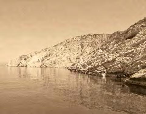


70 GODIŠNJE IZVJEŠĆE ANNUAL REPORT 2010


71 4Publikacije Publications
 6144 718 e-mail: tfluksi@hgi-cgs.hr GODI[NJE IZVJE[]E 2011. U 2011.")


72 PUBLIKACIJE Knjižnica Hrvatskog geološkog instituta Library of the HGI-CGS Voditeljica knjižnice / Head of the Library: Tea FLUKSI, prof. tel. (+385 1) fax. (+385 1) tfluksi@hgi-cgs.hr GODI[NJE IZVJE[]E U godini fond knjižnice Hrvatskog geološkog instituta povećan je za 252 knjige i 342 sveščića časopisa. Svakodnevno se radilo s korisnicima te im se pružala pomoć oko traženja literature, koja je najčešće nađena u srodnim knjižnicama na Prirodoslovno-matematičkom fakultetu i Rudarsko-geološkonaftnom fakultetu, ili pak naručena uslugom međuknjižnične posudbe preko Nacionalne sveučilišne knjižnice. I ove godine provedena je revizija uz otpis građe koju smo obavezni obavljati svake četiri godine. Otpisano je 409 knjiga i 52 sveščića časopisa koji su ili nestali ili oštećeni. Nacionalna i sveučilišna knjižnica ovaj je put bila zainteresirana za neke naslove pa su im ti naslovi dostavljeni na daljnje čuvanje. Knjižnica je i ove godine sudjelovala u poslovima vezanim uz časopis Geologia Croatica. Elektronička verzija objavljena na stranici hr sadržava i bazu autora čiji su podatci ujednačeni i provjereni. Članci Geologie Croatice odnedavno imaju i svoje DOI (Digital Object Identifier) brojeve po- In 2011, the HGI-CGS library added 252 books and 342 journal volumes to its collection. The library worked with clients on a daily basis by helping them search for literature that was most often found in the related libraries of the Faculty of Science and Faculty of Mining, Geology and Petroleum Engineering, or ordered by interlibrary loan through the National and University Library. GODIŠNJE IZVJEŠĆE ANNUAL REPORT 2010 Josip Terzić Godišnje izvješće 2010 Annual Report This year, an inventory was performed that included the write-off of library volumes, which we are obliged to perform every four years. A total of 409 books and 52 journal volumes that had been lost or damaged were written off. The National and University Library was also interested in some titles that we passed on to them. The library also participated in activities related to the journal Geologia Croatica. The online version, available at the web page www. geologia-croatica.hr, includes authors archives, the data of which have been standardised and verified. The journal s articles recently received their DOI (Digital Object Identifier) numbers to find and trace their citation index more 70 HRVATSKI GEOLOŠKI INSTITUT


73 moću kojih ih je lakše pronaći i pratiti njihovu citiranost. Razmjena domaćih i stranih časopisa s Geologiom Croaticom i ove je godine bila glavni način nabave novih časopisa. Doduše, dobili smo još nekoliko obavijesti stranih institucija koje zbog troškova odustaju od razmjene papirnatih primjeraka časopisa i prelaze na elektroničke pa smo odlučili razmjenu nastaviti na taj način. Za sljedeću godinu su najavljena određena uređenja u prostoru knjižnice te se polako počelo s pripremama i pospremanjem. Ispražnjena su dva ormara i knjižnica se sprema na novi i osvježeni izgled u kojem će se korisnici ugodnije osjećati. easily. The exchange of domestic and foreign scientific journals with Geologia Croatica was again the main mode of procurement of new journals. Indeed, we obtained notices from several foreign institutions that, due to increasing costs, had given up sending paper journals and had moved to an online mode of communication, which is why we also decided to follow that path. Spatial rearrangements of the library were announced for the coming year, and we began preparations and cleaning for this event. Two cabinets have been emptied, and the library is planning a new and refreshed look that will make clients feel more comfortable. ANNUAL REPORT 2011 PUBLICATIONS CROATIAN GEOLOGICAL SURVEY 71
74 PUBLIKACIJE Znanstveni časopis Geologia Croatica Scientific Journal Geologia Croatica Tehnički urednik / Technical editor: Dr. sc. Marija HORVAT marija.horvat@hgi-cgs.hr Geologia Croatica je znanstveni časopis Hrvatskog geološkog instituta (HGI) i Hrvatskog geološkog društva (HGD) koji objavljuje radove iz svih područja geoznanosti. Članci su na engleskom jeziku i međunarodno recenzirani, a zaprimaju se elektronski preko sustava OJS (Open Journal System). Sve informacije o časopisu mogu se dobiti na mrežnoj stranici časopisa: U godini redovito su tiskana tri sveska: 64/1, 64/2 i 64/3. Na 278 stranica objavljena su 22 znanstvena rada i In Memoriam prof. dr. Vladimiru Juraku ( ). Od djelatnika Hrvatskog geološkog instituta, njih šestero bili su koautori na pet originalnih znanstvenih radova objavljenih tijekom godine. Geologia Croatica is a scientific journal of the Croatian Geological Survey (HGI-CGS) and the Croatian Geological Society that is devoted to all fields of geoscience. Submission of papers is performed electronically through the Open Journal System. The articles are written in English and reviewed internationally. Information about the journal can be obtained through its website at In 2011, we published three single issues, 64/1, 64/2 and 64/3. Volume 64 consisted of 278 pages with 22 manuscripts and an In Memoriam piece for Professor Vladimir Jurak ( ). A list of 5 titles published in 2011 by six of CGS s employees can be found at the end of this Annual Report. Prirodno područje GODI[NJE IZVJE[]E red. br. Časopis izdaje Adresa Naslov časopisa 1 HRVATSKO KEMIJSKO DRUŠTVO Horvatovac 102 A/II, ZAGREB Croatica Chemica Acta HRVATSKO PRIRODOSLOVNO DRUŠTVO Frankopanska 1, ZAGREB Periodicum Biologorum ELEMENT,d.o.o. Menčetićeva 2, ZAGREB Mathematical Inequalities & Aplications PRIRODOSLOVNO-MATEMATIČKI FAKULTET, GEOFIZIČKI ZAVOD A.MOHOROVIČIĆ Horvatovac bb, ZAGREB Geofizika INSTITUT ZA OCEONOGRAFIJU I RIBARSTVO Šetalište I.Meštrovića 63, SPLIT Acta Adriatica PRIRODOSLOVNO-MATEMATIČKI FAKULTET Roosveltov trg 6, PP 333, ZAGREB Acta Botanica Croatica HRVATSKI GEOLOŠKI INSTITUT Sachsova 2, ZAGREB Geologia Croatica ELEMENT,d.o.o. Menčetićeva 2, ZAGREB Operators and Matrices SVEUČILIŠTE J.J.STROSSMAYERA, ODJEL ZA MATEMATIKU Trg Lj. Gaja 6, OSIJEK Mathematical Communications PRIRODOSLOVNO MATEMATIČKI FAKULTET, MATEMATIČKI ODJEL Bijenička 30, ZAGREB Glasnik matematički HRVATSKI PRIRODOSLOVNI MUZEJ Demetrova 1, ZAGREB Natura Croatica HRVATSKO GEOGRAFSKO DRUŠTVO Marulićev trg 19, ZAGREB Hrvatski geografski glasnik HRVATSKO ENTOMOLOŠKO DRUŠTVO Svetošimunska 25, ZAGREB Entomologia Croatica HRVATSKO GEOGRAFSKO DRUŠTVO Ul.dr.Franje Tuđmana bb, ZADAR Geoadria HRVASTSKO METEOROLOŠKO DRUŠTVO Grič 3, ZAGREB Hrvatski meteorološki časopis GEODETSKI FAKULTET Kačićeva 26, ZAGREB Central European Astrophysical Bulletin ELEMENT d.o.o. Menčetićeva 2, ZAGREB Differential equations and applicattions ELEMENT,d.o.o. Menčetićeva 2, ZAGREB Journal of Mathematical Inequalities 4.0 Ocjena vrsnoće za godinu prema MZOŠ (izvor: Assessment in the year 2011 according to the Ministry of Science, Education and Sports ( OCJENA VRSNOĆE U HRVATSKI GEOLOŠKI INSTITUT

75 Broj citata u posljednjih 15 godina izlaženja znanstvenog časopisa Geologia Croatica, zaključno s danom The number of citations in the last 15 years from the scientific journal Geologia Croatica until 14. November MZOS je u sufinanciralo izlaženje 214 znanstvenih, znanstvenostručnih časopisa i časopisa za popularizaciju znanosti. U okviru prirodnog područja od ukupno 18 časopisa, naš časopis se s 19 bodova našao na 7. mjestu prema ocijeni vrsnoće. Stalno radimo na poboljšanju kvalitete časopisa i na međunarodnoj prepoznatljivosti. Tako sljedeće godine dobivamo službeni čimbenik utjecaja od Thomson Reutersa jer nas prate od godine u bazi Web of Science. Prema SCOPUS-u, godinu smo završili na 86. mjestu od 150 geoloških časopisa, što je Q3 ili treća kvartila. SJR (SciMago Journal Rank čimbenik utjecaja) je iznosio 0,031. Od 102 hrvatska časopisa koja se prate, bili smo na 23. mjestu. Kontinuirano smo indeksirani i u Geo Abstracts, GeoRef, Geo- Archive, Geotitles, Geobase, MINABS Online, BIOSIS, Zoological Abstracts, PASCAL, Petroleum Abstracts, Chemical Abstracts, Current Geographical Abstracts i EBSCO Academic Search Complete. The Ministry of Science, Education and Sports financed the publishing of 214 scientific and professional journals and magazines. Within the area of natural sciences, our journal took 7 th place out of 18 journals with a total of 19 points based on the Ministry s quality assessment. We are constantly working to improve the quality of the journal and increase its international recognition. We should receive an official impact factor from Thomson Reuters in the next year. According to the SCOPUS bibliographic database, we placed 86 th in the third quartile (Q3) out of 150 geological journals. Our SciMago Journal Rank (SJR) was Out of 102 journals in Croatia, we took 23 rd place in the rankings. We are also regularly indexed in Geo Abstracts, GeoRef, GeoArchive, Geotitles, Geobase, MINABS Online, BIOSIS, Zoological Abstracts, PASCAL, Petroleum Abstracts, Chemical Abstracts, Current Geographical Abstracts and EBSCO Academic. ANNUAL REPORT 2011 PUBLICATIONS CROATIAN GEOLOGICAL SURVEY 73
Uvodnik Introduction. Dragutin Gorjanović-Kramberger ( ) 6
 6") Uvodnik Introduction 2 Dragutin Gorjanović-Kramberger (1856.-1936.) 6 Organizacijska struktura, zaposlenici i budžet Organizational scheme, employees and budget Zavod za geologiju Department of Geology
Uvodnik Introduction 2 Dragutin Gorjanović-Kramberger (1856.-1936.) 6 Organizacijska struktura, zaposlenici i budžet Organizational scheme, employees and budget Zavod za geologiju Department of Geology
Assistant Professor, University of Zagreb (Faculty of Mining, Geology and Petroleum Engineering)
") Proposal of Adriatic-Balkan ICL Network 1. Name of Network Adriatic-Balkan ICL Network 2. Name of Proposer Dr. Snježana Mihalić and Prof. Željko Arbanas Affiliation: position Dr. Snježana Mihalić Assistant
Proposal of Adriatic-Balkan ICL Network 1. Name of Network Adriatic-Balkan ICL Network 2. Name of Proposer Dr. Snježana Mihalić and Prof. Željko Arbanas Affiliation: position Dr. Snježana Mihalić Assistant
Improvements for Kosovo's spatial planning system / [presentation given in May 2011]
![Improvements for Kosovo's spatial planning system / [presentation given in May 2011]](/thumbs/95/122511393.jpg "Improvements for Kosovo's spatial planning system / [presentation given in May 2011]") Rochester Institute of Technology RIT Scholar Works Theses Thesis/Dissertation Collections 2011 Improvements for Kosovo's spatial planning system / [presentation given in May 2011] Luan Nushi Follow this
Rochester Institute of Technology RIT Scholar Works Theses Thesis/Dissertation Collections 2011 Improvements for Kosovo's spatial planning system / [presentation given in May 2011] Luan Nushi Follow this
Licensed Science Officer Benchmark
 POSITION EVALUATION RATIONALE POSITION TITLE MINISTRY AND DIVISION Energy, Mines and Petroleum Resources: Geology Division BRANCH AND SECTION Mineral Resources Branch, Applied Geology Section UNIT OR PROGRAM
Geological information for Europe : Towards a pan-european Geological Data Infrastructure
 Geological information for Europe : Towards a pan-european Geological Data Infrastructure Integrating geoscientific information for EU competitiveness Co-funded by the European Union European societal
One Geology as a tool for a crossborder geohazard assessment
 One Geology as a tool for a crossborder geohazard assessment A presentation due to the occasion of the 100 th Anniversary of the HGI-CGS Dr. Marko Komac Geological Survey of Slovenia Overview Introduction
Advancing Geoscientific Capability. Geological Survey of Finland
 Advancing Geoscientific Capability Geological Survey of Finland GTK in brief The Geological Survey of Finland (GTK) is one of the largest European centres of excellence in assessment, research and the
Potential Hydrocarbon Discoveries in Bjelovar Subdepression, Croatia By Tomislav Malvic 1 and Igor Rusan 2
 Potential Hydrocarbon Discoveries in Bjelovar Subdepression, Croatia By Tomislav Malvic 1 and Igor Rusan 2 Search and Discovery Article #10133 (2007) Posted September 25, 2007 1 INA-Industrija nafte, d.d.,
XXXVIII IAH Congress
 XXXVIII IAH Congress Groundwater Quality Sustainability Krakow, 12 17 September 2010 Extended Abstracts Editors: Andrzej Zuber Jarosław Kania Ewa Kmiecik University of Silesia Press 2010 abstract id: 155
UiT The Arctic University of Norway/Faculty of Science and Technology/Department of Geosciences
 Geology - Master Name: Norwegian (Bokmål): Geologi - Master Norwegian (Nynorsk): Geologi - Master English: Geology - Master Qualification awarded: Master of Science in Geology. Workload: 120 ECTS credits,
APPLICATION OF GIS DATA MODELLING FOR STONE AGGREGATE POTENTIAL IN DALMATIA
 APPLICATION OF GIS DATA MODELLING FOR STONE AGGREGATE POTENTIAL IN DALMATIA Željko Dedić (1) Ozren Hasan (1) Slobodan Miko (1) Boris Lukšić (1) Erli Kovačević (1) (1) Croatian Geological Survey; Sachsova
Licensed Science Officer Benchmark
 POSITION EVALUATION RATIONALE POSITION TITLE Senior Project Geologist MINISTRY AND DIVISION Energy, Mines and Petroleum Resources: Geological Division BRANCH AND SECTION Mineral Resources UNIT OR PROGRAM
Floods 2014 a wake up call to natural hazards
 Floods 2014 a wake up call to natural hazards Floods affected 119 municipalities (out of 165) 22% of total population affected by floods More than 30 municipalities sustained extensive damage 57 lives
Engineering Geology at University Complutense of Madrid: 30 years of postgraduate courses
 FIRST INTERNATIONAL CONFERENCE on EDUCATION and TRAINING in GEO-ENGINEERING ENGINEERING SCIENCES Constantza, Romania - June 2008 Engineering Geology at University Complutense of Madrid: 30 years of postgraduate
Department of Geology
 218 Department of Geology Department of Geology Chairperson: Abdel-Rahman, Abdel-Fattah M. rofessor: Abdel-Rahman, Abdel-Fattah M. Assistant rofessors: Elias, Ata R.; Haidar, Ali T.; Taborosi, Danko Instructors:
Geotechnical Engineering and Dams
 Geotechnical Engineering and Dams Solving Geotechnical Challenges for Hydropower and Water Resources Projects Geological and geotechnical challenges are often very demanding when planning hydraulic structures.
Harvey Thorleifson, Director, Minnesota Geological Survey. Status of geological mapping needed for groundwater protection in Minnesota
 Harvey Thorleifson, Director, Minnesota Geological Survey Status of geological mapping needed for groundwater protection in Minnesota Minnesota is located between the Dakotas and Wisconsin, north of Iowa,
Land Use in the context of sustainable, smart and inclusive growth
 Land Use in the context of sustainable, smart and inclusive growth François Salgé Ministry of sustainable development France facilitator EUROGI vice president AFIGéO board member 1 Introduction e-content+
Programme-specific Section of the Curriculum for the MSc Programme in at the Faculty of Science, University of Copenhagen Contents
 Programme-specific Section of the Curriculum for the MSc Programme in Geology-Geoscience at the Faculty of Science, University of Copenhagen 2009 (Rev. 2018) Contents 1 Title, affiliation and language...
DEPARTMENT OF GEOLOGY AND MINERAL INDUSTRIES WAYS & MEANS SUBCOMMITTEE ON NATURAL RESOURCES MARCH 2, 2017
 DEPARTMENT OF GEOLOGY AND MINERAL INDUSTRIES WAYS & MEANS SUBCOMMITTEE ON NATURAL RESOURCES MARCH 2, 2017 1 ABOUT DOGAMI AGENCY MISSION, VISION & GOALS 2 Lidar image of a stream network along the Umpqua
PERMANENT RESEARCH POSITION CHARGE DE RECHERCHE OPEN (M/F) in Geostatistics
 in Geostatistics") PERMANENT RESEARCH POSITION CHARGE DE RECHERCHE OPEN (M/F) in Geostatistics Institution : MINES ParisTech (Ecole Nationale Supérieure des Mines de Paris) Research Center : Centre de Géosciences In the
PERMANENT RESEARCH POSITION CHARGE DE RECHERCHE OPEN (M/F) in Geostatistics Institution : MINES ParisTech (Ecole Nationale Supérieure des Mines de Paris) Research Center : Centre de Géosciences In the
NAME OF THE PROGRAMME : M.Sc. GEOLOGY PROGRAMME OUTCOME
 NAME OF THE PROGRAMME : M.Sc. GEOLOGY PROGRAMME OUTCOME 1. Understanding development of landforms through Earth's external processes by various geological agents; marine processes and formation of marine
University of Mining and Geology
 University of Mining and Geology University of Mining and Geology 1. Introduction 2. The study at UMG 3. The research at UMG 4. International Cooperation University of Mining and Geology 1. Introduction
EuroGeoSurveys An Introduction
 EGS -ASGMI Workshop, Madrid, 2015 EuroGeoSurveys An Introduction 40 Years Listening to the Beat of the Earth Click to edit Master title Albania style EuroGeoSurveys Austria Lithuania Luxembourg Belgium
Cooperating Organization Report of Circum Pacific Council for Energy and Mineral Resources (CPC)
") CCOP-41AS/6.2-29 Coordinating Committee for Geoscience Programmes in East and Southeast Asia (CCOP) 41 st CCOP Annual Session 15 18 November 2004 Tsukuba, Japan Cooperating Organization Report of Circum
CCOP-41AS/6.2-29 Coordinating Committee for Geoscience Programmes in East and Southeast Asia (CCOP) 41 st CCOP Annual Session 15 18 November 2004 Tsukuba, Japan Cooperating Organization Report of Circum
Faculty of Science. Courses in Geology.
 Faculty of Science Courses in Geology www.port.ac.uk Courses in Geology BSc (Hons) Geology UCAS code: F600 Mode of study: 3 years full time Entry requirements: 104 120 points to include a minimum of 2
Department of Geology
 201 Chairperson: Abdel-Rahman, Abdel-Fattah M. Professor: Abdel-Rahman, Abdel-Fattah M. Assistant Professors: El-Kibbi, Maya M. Lecturer: P Haidar, Ali T. Instructors: P Khadra, Wisam M.; P Khayat, Ziad
GODI[NJE IZVJE[]E ANNUAL REPORT
![GODI[NJE IZVJE[]E ANNUAL REPORT](/thumbs/87/96179041.jpg "GODI[NJE IZVJE[]E ANNUAL REPORT") GODI[NJE IZVJE[]E ANNUAL REPORT 2009 NAKLADNIK PUBLISHER Hrvatski geološki institut Croatian Geological Survey Sachsova 2, HR-10000 Zagreb, Hrvatska (Croatia) ZA NAKLADNIKA FOR THE PUBLISHER UREDNIK EDITOR
GODI[NJE IZVJE[]E ANNUAL REPORT 2009 NAKLADNIK PUBLISHER Hrvatski geološki institut Croatian Geological Survey Sachsova 2, HR-10000 Zagreb, Hrvatska (Croatia) ZA NAKLADNIKA FOR THE PUBLISHER UREDNIK EDITOR
Plan4all (econtentplus project)
") Plan4all (econtentplus project) Karel CHARVAT 1, Tomáš MILDORF 2 1 Help service remote sensing, Ltd., Černoleská 1600, 256 01 Benešov u Prahy, Czech Republic charvat@bnhelp.cz 2 Department of Mathematics
Plan4all (econtentplus project) Karel CHARVAT 1, Tomáš MILDORF 2 1 Help service remote sensing, Ltd., Černoleská 1600, 256 01 Benešov u Prahy, Czech Republic charvat@bnhelp.cz 2 Department of Mathematics
Non-Governmental Organizations for Spatial Data Infrastructure. Environmental Democracy Case
 Non-Governmental Organizations for Spatial Data Infrastructure Environmental Democracy Case L.Jovičić, S.Vrečar, V.Cetl, K.Ristovski GSDI Small Grant Program Award 2011-2012 Non-Governmental Organisations
Geology and the Aggregate Industry: The Role of Geologists
 Geology and the Aggregate Industry: The Role of Geologists Donald G. Mikulic Illinois State Geological Survey Prairie Research Institute University of Illinois at Urbana-Champaign Outline Importance of
E UROPEAN PERSONAL INFORMATION WORK EXPERIENCE CURRICULUM VITAE FORMAT. Surname(s) / First name(s) Fax(es) +385-(0) Date of birth 14/12/1942
 / First name(s) Fax(es) +385-(0) Date of birth 14/12/1942") E UROPEAN CURRICULUM VITAE FORMAT PERSONAL INFORMATION Surname(s) / First name(s) Ružić Ivica Address(es) Work: Ruđer Bošković Institute, Bijenička 54, HR-10000 Zagreb, Croatia Private: Hrgovići 34, HR-10000
E UROPEAN CURRICULUM VITAE FORMAT PERSONAL INFORMATION Surname(s) / First name(s) Ružić Ivica Address(es) Work: Ruđer Bošković Institute, Bijenička 54, HR-10000 Zagreb, Croatia Private: Hrgovići 34, HR-10000
REPP-CO2 project overview. V. Hladík, O. Krejčí, J. Franců, V. Kolejka (Czech Geological Survey), R. Berenblyum (IRIS)
, R. Berenblyum (IRIS)") REPP-CO2 project overview V. Hladík, O. Krejčí, J. Franců, V. Kolejka (Czech Geological Survey), R. Berenblyum (IRIS) REPP-CO2 Preparation of a REsearch Pilot Project on CO2 Geological Storage in the Czech
REPP-CO2 project overview V. Hladík, O. Krejčí, J. Franců, V. Kolejka (Czech Geological Survey), R. Berenblyum (IRIS) REPP-CO2 Preparation of a REsearch Pilot Project on CO2 Geological Storage in the Czech
DEPARTMENT OF GEOSCIENCES
 DEPARTMENT OF GEOSCIENCES Office in Natural Resources Building, Room 322 (970) 491-7826 warnercnr.colostate.edu/geosciences-home (http:// warnercnr.colostate.edu/geosciences-home) Richard Aster, Department
CLLD Cooperation OFFER
 Title of the proposed project (English) CLLD Cooperation OFFER PARKS PROTECTION III - Management, Protection and Economic Development in Protected Areas Type of project (select as many as you want) Cooperation
Subject map. Custodians Geological Curators Group Geoscience Information Group Higher Education Network History of Geology Group
 Subject map In preparing the science strategy during 2013, Science and External Relations Committee (SERC) thought about how best to map the structure of geoscience, identifying its main disciplines, sub-disciplines
CEMAT results - over the years
 CEMAT results - over the years Technical Conference on Functional Areas capitalization of local potential within the territorial development policies in Europe European Conference of Ministers responsible
GEOLOGY (GEOL) Geology (GEOL) 1. GEOL 118 Societal Issues in Earth Science (4 crs)
 Geology (GEOL) 1. GEOL 118 Societal Issues in Earth Science (4 crs)") Geology (GEOL) 1 GEOLOGY (GEOL) GEOL 102 Oceanography (3 crs) Survey of the world oceans with emphasis on geologic processes. Also includes chemical, physical, and biological aspects of the sea. Investigates
Geology (GEOL) 1 GEOLOGY (GEOL) GEOL 102 Oceanography (3 crs) Survey of the world oceans with emphasis on geologic processes. Also includes chemical, physical, and biological aspects of the sea. Investigates
HARMONIZATION OF SEISMIC HAZARD MAPS FOR THE WESTERN BALKAN COUNTRIES : Overview of main BSHAP results
 Zagreb, Croatia Hotel Sheraton 12-13 May 2011 NATO SfP Project no. 983054 HARMONIZATION OF SEISMIC HAZARD MAPS FOR THE WESTERN BALKAN COUNTRIES : Overview of main BSHAP results Prof. Branislav Glavatović,
International Workshop on Groundwater Systems in Europe, August, 2013 Berlin
 Hydrogeological Mapping in Albania From the IHME contribution to larger scale national maps R. Eftimi, I. Tafilaj, G. Bisha & Xh. Sheganaku Mali me Gropa karst plateau Selita spring The hydrogeological
Access to MRM deposits in European countries and associated territories. Case Study: Aggregates plans and their future:
 WP6 Foresight study Access to MRM deposits in European countries and associated territories Case Study: Aggregates plans and their future: a view from South East Europe (SEE) countries Minerals4EU Final
WMO/WWRP FDP: INCA CE
 WMO/WWRP FDP: INCA CE Yong Wang ZAMG, Austria This project is implemented through the CENTRAL EUROPE Programme co-financed by the ERDF INCA CE: implementation over Central Europe A Nowcasting Initiative
HELSINKI COMMISSION Baltic Marine Environment Protection Commission
 HELSINKI COMMISSION Baltic Marine Environment Protection Commission HELCOM RECOMMENDATION 24/10 Adopted 25 June 2003, having regard to Article 20, Paragraph 1 b) of the 1992 Helsinki Convention IMPLEMENTATION
A Joint European GIS Under Construction: The 1:5 Million International Geological Map of Europe and Adjacent Areas (IGME 5000)
") Abstract 2001 Annual Conference of the International Association for Mathematical Geology Technical Program - Session I (Poster) Building National and Regional Geologic Map Databases A Joint European GIS
Abstract 2001 Annual Conference of the International Association for Mathematical Geology Technical Program - Session I (Poster) Building National and Regional Geologic Map Databases A Joint European GIS
Copernicus Today and Tomorrow GEO Week Group on Earth Observation Geneva, 16 January 2014 The Copernicus Space Infrastructure
 Copernicus Today and Tomorrow GEO Week Group on Earth Observation Geneva, 16 January 2014 The Copernicus Space Infrastructure Thomas Beer, Policy Coordinator, Copernicus Space Office, ESA-ESRIN, Frascati
Status of the Croatian First Order Gravity Network
 Status of the Croatian First Order Gravity Network Ž. HEĆIMOVIĆ 1, N. ROŽIĆ 1, T. BAŠIĆ 2, D. MARKOVINOVIĆ 2 Abstract Since Croatian Geodetic Institute (CGI) started to work in December 2001 preliminary
Croatian physical planning system and strategic approach to MSP
 W 1/7 Past two years all over the Europe: case studies 2 Croatian physical planning system and strategic approach to MSP Vesna Marohnić Kuzmanović Head of Department Croatian Institute for Spatial Development
Earth Observation and GEOSS in Horizon Copernicus for Raw Material Workshop 5 th September 2016
 Earth Observation and GEOSS in Horizon 2020 Copernicus for Raw Material Workshop 5 th September 2016 Gilles OLLIER Head of Sector -Earth observation Directorate Environment Unit I.4 Climate Actions and
What can I do with a major in Earth Information Science?
 Lewis-Clark State College offers a Bachelor of Arts or Science Degree in Earth Information Science through the Natural Sciences and Mathematics Division. You can learn more about the Natural Sciences and
ENVIRONMENTAL GEOSCIENCE UNIFORM SYLLABUS
 ENVIRONMENTAL GEOSCIENCE UNIFORM SYLLABUS The Association of Professional Engineers and Geoscientists of the Province of British Columbia Note: 1. This Syllabus May Be Subject To Change 2. These Courses
SEISMIC RISK ASSESSMENT IN ARMENIA
 SEISMIC RISK ASSESSMENT IN ARMENIA Hovhannes Khangeldyan Head of National Crisis Management Center Rescue Service Ministry of Emergency Situations of the Republic of Armenia Tokyo, 2016 ARMENIA: GEOGRAPHICAL
E-Government and SDI in Bavaria, Germany
 135 E-Government and SDI in Bavaria, Germany Wolfgang STOESSEL, Germany Key words: GDI-BY, Bavaria, Spatial Data Infrastructure SUMMARY Spatial Data Infrastructure (SDI) is an important part of the e-government
UNOFFICIAL TRANSLATION
 UNOFFICIAL TRANSLATION THE CROATIAN PARLIAMENT 1135 Pursuant to Article 89 of the Constitution of the Republic of Croatia, I hereby issue the DECISION PROMULGATING THE NATIONAL SPATIAL DATA INFRASTRUCTURE
Geology (GEOL) Courses
 Courses") Geology (GEOL) 1 Geology (GEOL) Courses GEOL 101. Introductory Geology. 5 (GE=B3), Winter, Spring, Summer An introduction to the study of the earth, particularly the structure, composition, distribution
Geology (GEOL) 1 Geology (GEOL) Courses GEOL 101. Introductory Geology. 5 (GE=B3), Winter, Spring, Summer An introduction to the study of the earth, particularly the structure, composition, distribution
Geologia Croatica 66/ Figs. 7 Tabs. Zagreb Geothermal properties of the northern part of the island of Rab
 66/1 29 37 6 Figs. 7 Tabs. Zagreb 2013 Geothermal properties of the northern part of the island of Rab Miron Kovačić Croatian Geological Survey, Zagreb, Croatia; (miron.kovacic@hgi-cgs.hr) doi: 10.4154/gc.2013.03
Curriculum for the Master s Programme in Geosciences at the Faculty of Earth and Atmospheric Sciences of the University of Innsbruck
 The English version of the curriculum for the Master s Programme in Geosciences is not legally binding and is for informational purposes only. The legal basis is regulated in the curriculum published in
ROYAL HOLLOWAY University of London PROGRAMME SPECIFICATION
 ROYAL HOLLOWAY University of London PROGRAMME SPECIFICATION This document describes MSci Honours Degree programmes in Geoscience, with an option to undertake either a Year in Industry or a Year of International
about GCC
 about GCC Bldg 234, Flat 11, Al Barakat Street, Hail Al Janaubiyah P.O Box: 94, Postal Code: 123, Al Khaudh, Sultante of Oman Fax : +968 24543188 Mobile :+968 96666445 info@gcc-oman.com www.gcc-oman.com
M. Mikoš. Faculty of Civil and Geodetic Engineering, University of Ljubljana, Ljubljana, Slovenia
 Proceedings of the Mediterranean Meeting on Monitoring, modelling and early warning of extreme events triggered by heavy rainfalls. PON 01_01503 - MED-FRIEND project University of Calabria, Cosenza (Italy),
THE SEVILLE STRATEGY ON BIOSPHERE RESERVES
 THE SEVILLE STRATEGY ON BIOSPHERE RESERVES 1 VISION FOR BIOSPHERE RESERVES IN THE 21 ST CENTURY The international Seville Conference on Biosphere Reserves, organised by UNESCO, adopted a two-pronged approach,
Implementation of the ESPON 2020 cooperation program. 16 January 2017 Anneloes van Noordt
 Implementation of the ESPON 2020 cooperation program 16 January 2017 Anneloes van Noordt Outline! ESPON Cooperation Program! Specific Objectives! Applied Research! Targeted Analysis! Database & Tools!
The Governance of Land Use
 The Governance of Land Use Country fact sheet Czech Republic The planning system Levels of government and their responsibilities The Czech Republic is a unitary state with 3 levels of government: the national
Department of Geology
 225 Department of Geology Chairperson: Abdel-Rahman, Abdel-Fattah M. Professor: Abdel-Rahman, Abdel-Fattah M. Assistant Professors: El-Kibbi, Maya M.; Nader, Fadi H. Lecturer: P Haidar, Ali T. Instructors:
Mongolian Geological Survey present
 1 Officially Mongolian Geological Survey established 76 years ago in 1939 and since that time Mongolian and foreign geologists continuously studied geology and mineral resources of the country. The history
Seismic Interpretation & Exploration
 Seismic Interpretation & Exploration Ecolog is a private consulting and design firm established in 2002, with a track record of designing, managing and executing exploration activities and geophysical-geological
Bachelor of Science in Geology
 Bachelor of Science in Geology 1 Bachelor of Science in Geology Why study geology? In Geology you get to apply techniques and knowledge from chemistry, physics, biology and math to answer important questions
Legal problems of environmental management. Spatial planning and space management. M. Gajewski 2014 / 2015
 Legal problems of environmental management Spatial planning and space management M. Gajewski 2014 / 2015 Course contents (in brief) Constitutional basis of the environment protection system. General principles
Economic and Social Council
 United Nations Economic and Social Council Distr.: General 2 July 2012 E/C.20/2012/10/Add.1 Original: English Committee of Experts on Global Geospatial Information Management Second session New York, 13-15
GEOGRAPHY (GE) Courses of Instruction
 Courses of Instruction") GEOGRAPHY (GE) GE 102. (3) World Regional Geography. The geographic method of inquiry is used to examine, describe, explain, and analyze the human and physical environments of the major regions of the
GEOGRAPHY (GE) GE 102. (3) World Regional Geography. The geographic method of inquiry is used to examine, describe, explain, and analyze the human and physical environments of the major regions of the
GEOLOGY & ENVIRONMENTAL GEOSCIENCES (GEOL)
") Geology & Environmental Geosciences (GEOL) 1 GEOLOGY & ENVIRONMENTAL GEOSCIENCES (GEOL) Faculty Professors: Christopher G. Daniel (Chair), Mary Beth Gray, Carl S. Kirby, R. Craig Kochel, Jeffrey M. Trop
Geology & Environmental Geosciences (GEOL) 1 GEOLOGY & ENVIRONMENTAL GEOSCIENCES (GEOL) Faculty Professors: Christopher G. Daniel (Chair), Mary Beth Gray, Carl S. Kirby, R. Craig Kochel, Jeffrey M. Trop
Summary: This paper updates the Sub-committee on current thinking regarding the proposal for a Cotswolds Geopark
 REFRESH OF THE PROPOSAL FOR A COTSWOLDS GEOPARK Summary: This paper updates the Sub-committee on current thinking regarding the proposal for a Cotswolds Geopark Recommendations: a) That the Sub-committee
Influence of land use in small karst catchments on the chemical status of peloid sediments on the eastern Adriatic coast
 Influence of land use in small karst catchments on the chemical status of peloid sediments on the eastern Adriatic coast Slobodan Miko 1, Šparica Marko 1, Georg Koch 1, Martina Šparica Miko 1, Stanislav
EUROPEAN INVESTMENT BANK
 EUROPEAN INVESTMENT BANK RISC Consortium and the UNU-CRIS Summer School/ Students Research Symposium, 3 rd July 2012, Luxembourg Regional Projects good practice? Kamil Dörfler 1 Outline General background
EUSAIR on sea topics from Slovenian perspective
 MINISTRY OF FOREIGN AFFAIRS REPUBLIC OF SLOVENIA EUSAIR on sea topics from Slovenian perspective Mag. Andreja Jerina National Coordinator 4 EU MRS: 270 millions of population 19 MS 12 non MS Sea basin
Strengthening the cooperation in the region: Carpathian, Tisa,, Danube and Black Sea areas
 Strengthening the cooperation in the region: Carpathian, Tisa,, Danube and Black Sea areas 14th October 2009 SEE Annual Conference Advancing development through transnational cooperation in South East
Study program: Geology. Semester I Required subject Code Subject ECTS. Hours per week
 Study program: Geology Semester I 2FI100112 Math 1 8 3+2+2 216 2FP100212 Physics 1 8 3+2+2 216 UGD101312 Computer Science 6 2+2+1 156 1 4 2+1+1 120 2 4 2+1+1 120 : 2FP110112 Basics geology 2FP101212 Fundamentals
Global Geospatial Information Management Country Report Finland. Submitted by Director General Jarmo Ratia, National Land Survey
 Global Geospatial Information Management Country Report Finland Submitted by Director General Jarmo Ratia, National Land Survey Global Geospatial Information Management Country Report Finland Background
GEOCHEMISTRY UNIFORM SYLLABUS
 GEOCHEMISTRY UNIFORM SYLLABUS The Association of Professional Engineers and Geoscientists of the Province of British Columbia Note: 1. This Syllabus May Be Subject To Change 2. These Courses Are Required
A Career Mineral Exploration, Resource and Mining Geology
 1 A Career Mineral Exploration, Resource and Mining Geology Presenter: Ben Lepley Location: BGS, Keyworth My Journey so Far 2 Love of mountains Geology A Level BSc/MESci in Geology (no specialisation)
GIS Geographical Information Systems. GIS Management
 GIS Geographical Information Systems GIS Management Difficulties on establishing a GIS Funding GIS Determining Project Standards Data Gathering Map Development Recruiting GIS Professionals Educating Staff
UNDERGRADUATE HANDBOOK 2017 EARTH SCIENCES
 UNDERGRADUATE HANDBOOK 2017 EARTH SCIENCES Welcome to the School of Environment Earth Sciences at the University of Auckland combines geology and physical geography into an integrated programme that is
SUSTAINABLE GROWTH FROM GEOLOGY. gtk.fi
 SUSTAINABLE GROWTH FROM GEOLOGY gtk.fi Geological Survey of Finland The Geological Survey of Finland (GTK) is a leading European competence centre for the assessment and sustainable use of geological resources.
GEOCHEMISTRY RESEARCH GROUP projects & research
 PATHWAY GEOCHEMISTRY RESEARCH GROUP projects & research MOROCCO-HUNGARY Bilateral Project Meknes 2012 GYOZO JORDAN Geochemistry Department, Hungarian Geological and Geophysical Institute RECEPTOR SOURCE
Economic and Social Council
 United Nations Economic and Social Council Distr.: General 18 July 2016 Original: English Committee of Experts on Global Geospatial Information Management Sixth session New York, 3-5 August 2016 Item 2
Earth and Environmental Science (EES)
") Earth and Environmental Science (EES) 1 Earth and Environmental Science (EES) Courses EES 5011. Remote Sensing and GIS. 4 Credit Hours. The focus of this class is on remote sensing technologies and geographic
Earth and Environmental Science (EES) 1 Earth and Environmental Science (EES) Courses EES 5011. Remote Sensing and GIS. 4 Credit Hours. The focus of this class is on remote sensing technologies and geographic
EMPLOYER SURVEY 2001 of the UNDERGRADUATE PROGRAM DEPARTMENT OF GEOLOGY AND GEOPHYSICS
 EMPLOYER SURVEY 2001 of the UNDERGRADUATE PROGRAM DEPARTMENT OF GEOLOGY AND GEOPHYSICS INTRODUCTION An employer survey was conducted as part of a series of surveys undertaken to meet the accreditation
Mediterranean Sea and Territorial Development, Opportunities and Risks
 EESC Hearing Towards an EU Macro-Regional Strategy for the Mediterranean Mediterranean Sea and Territorial Development, Opportunities and Risks Michaela Gensheimer Structure of Intervention Part I: What
ASSESSMENT OF STUDENT LEARNING Department of Geology University of Puerto Rico at Mayaguez. Progress Report
 ASSESSMENT OF STUDENT LEARNING Department of Geology University of Puerto Rico at Mayaguez Progress Report Period of Report August to December of 2004. Purpose of our Assessment The fundamental purpose
THE ROLE OF SEAMIC IN SUSTAINABLE MINERAL RESOURCES DEVELOPMENT IN AFRICA
 THE ROLE OF SEAMIC IN SUSTAINABLE MINERAL RESOURCES DEVELOPMENT IN AFRICA Ketema Tadesse Director General-SEAMIC Dar es Salaam, Tanzania August 11, 2009 SEAMIC BACKGROUND SEAMIC was established in 1977
ICT A LEVER OF ECONOMIC DEVELOPMENT OF THE SLAVONIA AND BARANJA REGION ICT - POLUGA RAZVOJA GOSPODARSTVA SLAVONIJE I BARANJE
 Franjo Jović, PhD. Faculty of Electrical Engineering Osijek and Croatian Academy of Engineering, Zagreb Tel. +385 31 224-600; Email: jovic@etfos.hr Milan Ivanović, PhD. Faculty of Electrical Engineering
Norwegian spatial data infrastructure supporting disaster risk management Norwegian Mapping Authority
 Norwegian spatial data infrastructure supporting disaster risk management Norwegian Mapping Authority Arvid Lillethun, Norwegian Mapping Authority Land and Poverty 2018 Conference, World Bank 19.-23. March
a national geological survey perspective François ROBIDA BRGM (French Geological Survey)
") a national geological survey perspective François ROBIDA BRGM (French Geological Survey) Pre-Conference Seminar on Socio-Economic Value of Geospatial for National and Regional Development 21 August 2017,
a national geological survey perspective François ROBIDA BRGM (French Geological Survey) Pre-Conference Seminar on Socio-Economic Value of Geospatial for National and Regional Development 21 August 2017,
Consulting Geologist Geologischer Berater Géologue Conseil Geologo Consulente
 Consulting Geologist Geologischer Berater Géologue Conseil Geologo Consulente Rinaldo Volpers geologist dipl. sc. nat. ETH Zurich member of SIA/OTIA/CHGeol/SSH CH - 6763 Osco (Switzerland) phone : 0041
INCA CE: Integrating Nowcasting with crisis management and risk prevention in a transnational framework
 INCA CE: Integrating Nowcasting with crisis management and risk prevention in a transnational framework Yong Wang ZAMG, Austria This project is implemented through the CENTRAL EUROPE Programme co-financed
Guidelines for Site-Specific Seismic Hazard Reports for Essential and Hazardous Facilities and Major and Special-Occupancy Structures in Oregon
 Guidelines for Site-Specific Seismic Hazard Reports for Essential and Hazardous Facilities and Major and Special-Occupancy Structures in Oregon By the Oregon Board of Geologist Examiners and the Oregon
PROPOSED CCOP WORKPLAN 2019
 CCOP-54AS/6- CCOP-71SC/3-4 as of 10 October 2018 COORDINATING COMMITTEE FOR GEOSCIENCE PROGRAMMES IN EAST AND SOUTHEAST ASIA (CCOP) 54 th CCOP Annual Session 71 st CCOP Steering Committee Meeting 28 October
Carpathians Unite mechanism of consultation and cooperation for implementation of the Carpathian Convention
 Carpathians Unite mechanism of consultation and cooperation for implementation of the Carpathian Convention Zbigniew Niewiadomski, UNEP/GRID-Warsaw Centre First Joint Meeting of the Carpathian Convention
Geological Survey of Canada Lands and Minerals Sector Natural Resources Canada OneGeology, June 2018
 Geological Survey of Canada Lands and Minerals Sector Natural Resources Canada OneGeology, June 2018 Geological Survey of Canada Mission The Geological Survey of Canada provides public geoscience knowledge
Curriculum for the Bachelor s Programme Earth Science at the Faculty of Geo- and Atmospheric Sciences as the University of Innsbruck
 Note: The following curriculum is a consolidated version. It is legally non-binding and for informational purposes only. The legally binding versions are found in the University of Innsbruck Bulletins
General Information. Introduction of China University of Geosciences(Beijing) for International Students
 for International Students") Introduction of China University of Geosciences(Beijing) for International Students General Information China University of Geosciences(Beijing) is located on Xueyuan Road, Haidian District, surrounded
Introduction of China University of Geosciences(Beijing) for International Students General Information China University of Geosciences(Beijing) is located on Xueyuan Road, Haidian District, surrounded