Access to MRM deposits in European countries and associated territories. Case Study: Aggregates plans and their future:
|
|
|
- Noel Nelson Robertson
- 5 years ago
- Views:
Transcription
1 WP6 Foresight study Access to MRM deposits in European countries and associated territories Case Study: Aggregates plans and their future: a view from South East Europe (SEE) countries Minerals4EU Final Conference in Brussels, 25 August 2015 Željko Dedić, HGI-CGS
2 Introduction Securing reliable and undistorted access to raw materials is an increasingly important factor for the EU s economic competitiveness. One of the pillars of The Raw Materials Initiative (adopted by EC) is setting the right framework conditions within the EU in order to foster a sustainable supply from European sources (EC Guidance 2010). To maintain access to aggregates in South East Europe (SEE) several gg g p ( ) projects were launched (SARMa and SNAP-SEE) dealing with this important challenge for the SEE countries. This report summarises some the most important issues related to aggregate access and shows the study case of SEE and Croatia where mineral planning is obligatory both on National and regional level and access to minerals and aggregates is a part of national and regional spatial plans.
3 Situation in SEE Aggregates have essential importance to the economic growth The access to aggregates is becoming increasingly difficult sterilizing areas with resource extraction potential a. protected areas (e.g. biodiversity conservation and cultural heritage sites) a. social attitudes b. the development of buildings and roads The planning of aggregate supply is essential. Figure 3 compares the data for national tonnes/capita to its GDP/capita. Each point on the graph represents individual countries, and the red line shows the overall trend. This graph demonstrates t that t the need for aggregates in tonnes/capita grows as an economy grows, which is hopefully good news for the aggregates industry, once the current deep recession is ended The authorities responsible for aggregates planning are mining; land use planning and other authorities at national and regional level various in countries
4 Legal barriers against aggregates planning development Lack of regulations (Herzegbosnian Canton, Serbia) Lack of coordination between involved and responsible institutions (Slovenia) Lack of uniform terms harmonizing with EU project suggestions (Romania, Hungary) Problems with legal definition: depending on origin the same type of aggregates may subject to different procedures (Trento) Problems with the ownership of land (Albania, Slovakia) Problems with land use planning extracting aggregates from the water table is a sensitive issue (Austria) only the active quarries are considered by the spatial plan (Croatia) mismatches of local and national spatial plan (Montenegro) NATURA 2000 program obstructs the quarrying (Austria, Slovenia, Hungary)
5 Planning The potential conflicts of quarrying and nature protected areas are not treated adequately during in all countries. In several SEE countries the Land Use Planning Policy Framework contains important information for Aggregates Planning: e.g. protected areas of nature or culture however regarding the designated mining areas there is a lack of information for aggregates. The minerals planning policy is part of the national minerals policy framework (Tiess, 2011; EC, 2010b). 0b). A national a aggregate e policy can be defined ed as the entirety of operations of a state for influencing supply of and demand for mineral resources on its territory (Tiess, 2011). It involves protection of aggregates g deposits through land use planning (i.e., securing raw materials supply).


")

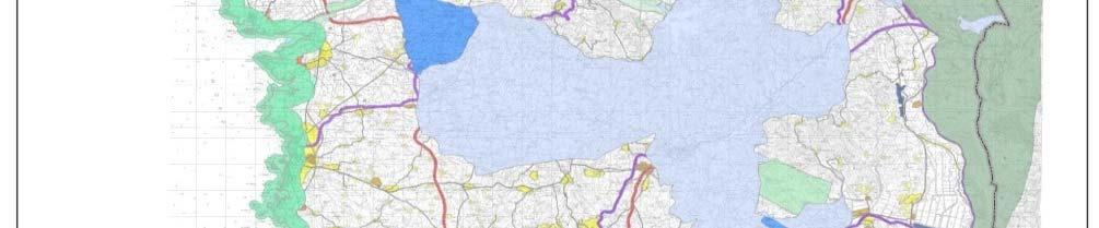
6 Planning The step of regional planning is especially important for the regulation of raw materials issues. With the help of well- established statements, regional plans (based on broader development programs, like national and super-regional ones) determine the regional goals of land use planning for the development of single districts. Figure 4. Croatian mineral planning
7 Planning A regional land use plan designed for the extraction and protection of mineral resources must contain a precise planning flow chart and a textual statement. The textual statement included in the plan must define aggregates priority zones that should be safeguarded, while carefully considering the medium and long-term mineral resources demands, and the limited availability of mineral resources deposits.
8 Principles In the SEE countries the most comprehensive is minerals plan achieved at the national level is the Austrian Mineral Resources Plan (AMRP) was developed (and published in 2010) in close cooperation with the regional governments. The mineral plans of countries such a Croatia (County Minerals Plans), Slovenia (National Programme for Mineral Resources Management -NPMRM) and the Autonomous Province of Trento, follow the principles outlined by (Cibin et al, 2011; Furin et al., 2011): 1. Aggregates demand and supply sources (Geology and economics) 2. Aggregates availability (Spatial planning restrictions) 3. Potential impacts (Environmental impacts, social impacts) 4. Life Cycle Analysis (usually not applied) 5. Scenarios (supply/demand)
9 Regional planning The suitability zone maps drawn up using geoscientific methods were digitally overlaid on the digital regional planning data made available by the provincial governments. The respective regional planning specifications were broken down into so called prohibition and conflict zones. Prohibition zones are those areas in which the extraction of mineral raw materials is forbidden by federal or provincial law. Conflict zones are defined as those areas in which there are obstacles to extraction. These areas include, for example, Nature 2000 areas, where raw materials can only be extracted if there has been a positive nature compatibility analysis. The individual provinces define the conflict zones very differently, both in terms of their content and scope. Separation distances/buffer zones may be appropriate in specific circumstances where it is clear that, based on site specific assessments and other forms of mitigation measures (such as working scheme design and landscaping) a certain distance is required between the boundary of the minerals extraction area and occupied residential property.


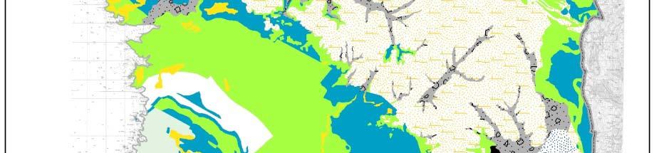
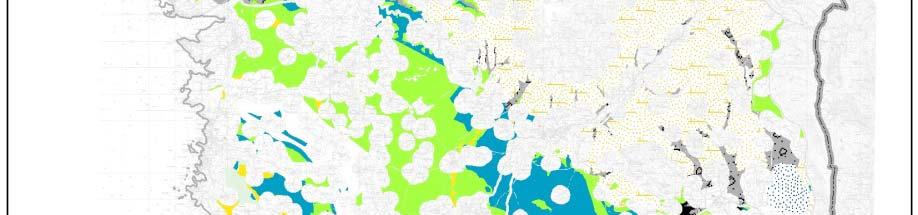


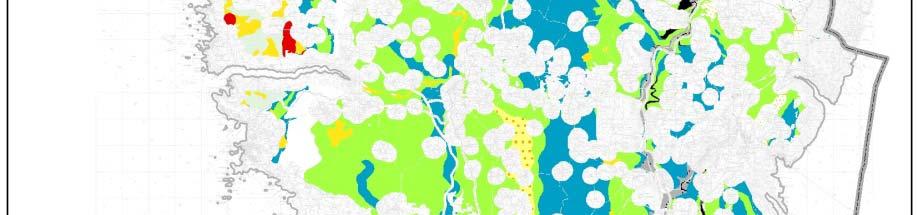
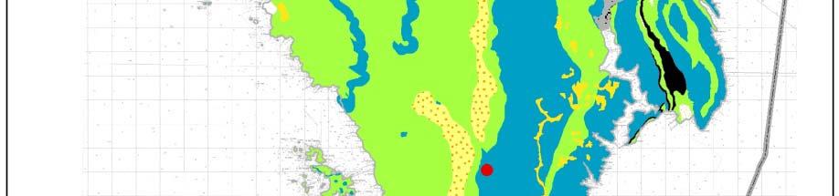

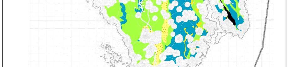
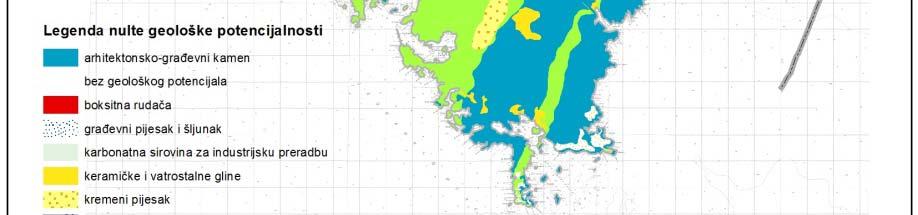

10 Example : Croatia Map of the basic geological potentiality of Istria County (1: 100, 000) Map of prohibiting the exploitation of Istria County Map of potential areas for exploitation of mineral resources in relation to the terms of use, physical planning and protection of Istria County


11 Thank you for you attention! Željko Dedić, HGI-CGS: National park KRKA Expedition crew at Maslenica Bridge Minerals4EU Final Conference in Brussels, 25 August 2015
Geological information for Europe : Towards a pan-european Geological Data Infrastructure
 Geological information for Europe : Towards a pan-european Geological Data Infrastructure Integrating geoscientific information for EU competitiveness Co-funded by the European Union European societal
EuroGeoSurveys & ASGMI The Geological Surveys of Europe and IberoAmerica
 EuroGeoSurveys & ASGMI The Geological Surveys of Europe and IberoAmerica Geological Surveys, what role? Legal mandate for data & information: Research Collection Management Interpretation/transformation
Land Use Planning and Agriculture: Austrian Experiences and Challenges I
 Land Use Planning and Agriculture: Austrian Experiences and Challenges I SULANET Summer School 2016 Walter Seher BOKU Vienna 1 Land Use Planning and Agriculture 2 Land Use Planning and Agriculture Agriculture
40 Years Listening to the Beat of the Earth
 EuroGeoSurveys The role of EuroGeoSurveys in Europe-Africa geoscientific cooperation 40 Years Listening to the Beat of the Earth EuroGeoSurveys 32 Albania Lithuania Austria Luxembourg Belgium The Netherlands
MODELS AND TOOLS FOR GOVERNANCE OF
 Working Papers Collection No. 1/2015 MODELS AND TOOLS FOR GOVERNANCE OF THE ADRIATIC AND IONIAN SEAS www.unimc.it/maremap NATIONAL POLITICS AND EU POLITICS: THE MARITIME SPATIAL PLANNING AND INTEGRATED
Strengthening the cooperation in the region: Carpathian, Tisa,, Danube and Black Sea areas
 Strengthening the cooperation in the region: Carpathian, Tisa,, Danube and Black Sea areas 14th October 2009 SEE Annual Conference Advancing development through transnational cooperation in South East
APPLICATION OF GIS DATA MODELLING FOR STONE AGGREGATE POTENTIAL IN DALMATIA
 APPLICATION OF GIS DATA MODELLING FOR STONE AGGREGATE POTENTIAL IN DALMATIA Željko Dedić (1) Ozren Hasan (1) Slobodan Miko (1) Boris Lukšić (1) Erli Kovačević (1) (1) Croatian Geological Survey; Sachsova
EuroGeoSurveys An Introduction
 EGS -ASGMI Workshop, Madrid, 2015 EuroGeoSurveys An Introduction 40 Years Listening to the Beat of the Earth Click to edit Master title Albania style EuroGeoSurveys Austria Lithuania Luxembourg Belgium
Natura 2000 and spatial planning. Executive summary
 Natura 2000 and spatial planning Executive summary DISCLAIMER The information and views set out in this study are those of the author(s) and do not necessarily reflect the official opinion of the Commission.
Adaptation to Climate Change in other Mountain Regions
 Adaptation to Climate Change in other Mountain Regions First Working Group of the Carpathian Convention on Adaptation to Climate Change Brussels, 4-5 February 2012 Pictures: A. Czaderna, A.& D. Nowak,
PROTOCOL ON THE IMPLEMENTATION OF THE ALPINE CONVENTION OF 1991 RELATING TO SPATIAL PLANNING AND SUSTAINABLE DEVELOPMENT
 PROTOCOL ON THE IMPLEMENTATION OF THE ALPINE CONVENTION OF 1991 RELATING TO SPATIAL PLANNING AND SUSTAINABLE DEVELOPMENT SPATIAL PLANNING AND SUSTAINABLE DEVELOPMENT" PROTOCOL Preamble The Republic of
European Landscape Convention in the Slovak Republic
 13th COUNCIL OF EUROPE MEETING OF THE WORKSHOPS FOR THE EUROPEAN LANDSCAPE CONVENTION European Landscape Convention in the Slovak Republic Mrs. Ida Vanáková, state advisor, Department of Spatial Planning
SPLAN-Natura Towards an integrated spatial planning approach for Natura th January, 2017 Brussels. Commissioned by DG Environment
 SPLAN-Natura 2000 Towards an integrated spatial planning approach for Natura 2000 Commissioned by DG Environment 17 th January, 2017 Brussels V. Simeonova (Ph.D.) Drivers towards integrating Biodiversity
The Governance of Land Use
 The planning system The Governance of Land Use United Kingdom Levels of government and their responsibilities The United Kingdom is a unitary state with three devolved governments in Northern Ireland,
Summary: This paper updates the Sub-committee on current thinking regarding the proposal for a Cotswolds Geopark
 REFRESH OF THE PROPOSAL FOR A COTSWOLDS GEOPARK Summary: This paper updates the Sub-committee on current thinking regarding the proposal for a Cotswolds Geopark Recommendations: a) That the Sub-committee
EUSAIR on sea topics from Slovenian perspective
 MINISTRY OF FOREIGN AFFAIRS REPUBLIC OF SLOVENIA EUSAIR on sea topics from Slovenian perspective Mag. Andreja Jerina National Coordinator 4 EU MRS: 270 millions of population 19 MS 12 non MS Sea basin
Restoration of the Sediment Balance in the Danube River DanubeSediment. Sándor Baranya, BME
 Restoration of the Sediment Balance in the Danube River DanubeSediment Sándor Baranya, BME Sediment related problems in the Danube River Increasing discrepancy between surplus and deficit of sediment increases
16540/14 EE/cm 1 DG E 1A
 Council of the European Union Brussels, 5 December 2014 (OR. en) 16540/14 ENV 965 CULT 139 NOTE From: To: Subject: General Secretariat of the Council Delegations Charter of Rome on Natural and Cultural
Management of Sediment Quality and Quantity in the Danube River Basin
 Management of Sediment Quality and Quantity in the Danube River Basin 5 th SedNet Conference 27-29 May 2008 Oslo (N) Igor Liska ICPDR igor.liska@unvienna.org CONTENT ICPDR & EU WFD implementation Sediment
Land Use in the context of sustainable, smart and inclusive growth
 Land Use in the context of sustainable, smart and inclusive growth François Salgé Ministry of sustainable development France facilitator EUROGI vice president AFIGéO board member 1 Introduction e-content+
OPINION. Results of EU Structural Policy in NSPA
 OPINION on the future European Cohesion Policy of the Northern Sparsely Populated Areas (NSPA) of Finland and Sweden with the contribution of North Norway The remote Northern Sparsely Populated Areas (NSPA)
EXPERT ANALYSIS ON GEOGRAPHICAL SPECIFICITIES
 EXPERT ANALYSIS ON GEOGRAPHICAL SPECIFICITIES Mountains, Islands and Sparsely Populated Areas Dr. Gilda Carbone 9 Oct 2018 Objectives: to gather basic information from relevant programming documents (PAs,
The Governance of Land Use
 The planning system Levels of government and their responsibilities The Governance of Land Use Country fact sheet Germany Germany is a federal country with four levels of government. Below the national
Advancing Geoscientific Capability. Geological Survey of Finland
 Advancing Geoscientific Capability Geological Survey of Finland GTK in brief The Geological Survey of Finland (GTK) is one of the largest European centres of excellence in assessment, research and the
PROSPECTIVE AREAS FOR CRITICAL RAW MATERIALS IN THE EU
 This project has received funding from the European Union s Horizon 2020 research and innovation programme under grant agreement No. 776487 Ref. Ares(2017)5879386-30/11/2017 PROSPECTIVE AREAS FOR CRITICAL
Integrated Strategies in regional development
 Inspire policy making by territorial evidence ESPON Seminar Territories Acting for Economic Growth: Using territorial evidence to meet challenges towards 2020 Integrated Strategies in regional development
National planning report for Denmark
 National planning report for Denmark from the Minister for Environment and Energy Local identity and new challenges Summary 2000 1 CONTENTS 4 PREFACE: REGIONAL DEVELOPMENT AND SPATIAL PLANNING 6 1. BALANCED
WHO EpiData. A monthly summary of the epidemiological data on selected Vaccine preventable diseases in the WHO European Region
 A monthly summary of the epidemiological data on selected Vaccine preventable diseases in the WHO European Region Table 1: Reported cases for the period January December 2018 (data as of 01 February 2019)
National Adaptation Geo-information System (NAGiS) project in Hungary
 project in Hungary") National Adaptation Geo-information System (NAGiS) project in Hungary Mr. Péter Kajner Hungarian Mining and Geological Survey (MBFSZ) National Adaptation Center Department CGE webinar: Geo-information
National Adaptation Geo-information System (NAGiS) project in Hungary Mr. Péter Kajner Hungarian Mining and Geological Survey (MBFSZ) National Adaptation Center Department CGE webinar: Geo-information
Legal problems of environmental management. Spatial planning and space management. M. Gajewski 2014 / 2015
 Legal problems of environmental management Spatial planning and space management M. Gajewski 2014 / 2015 Course contents (in brief) Constitutional basis of the environment protection system. General principles
The Governance of Land Use
 The planning system Levels of government and their responsibilities The Governance of Land Use COUNTRY FACT SHEET NORWAY Norway is a unitary state with three levels of government; the national level, 19
GeoERA Raw Materials Mineral Intelligence for Europe (MINTELL4EU)
") GeoERA Raw Materials Mineral Intelligence for Europe (MINTELL4EU) Improving and sustaining the EURMKB Pedro Delgado Department of Geological Resources Research GEOLOGICAL SURVEY OF SPAIN Horizon 2020 Co-funded
GeoERA Raw Materials Mineral Intelligence for Europe (MINTELL4EU) Improving and sustaining the EURMKB Pedro Delgado Department of Geological Resources Research GEOLOGICAL SURVEY OF SPAIN Horizon 2020 Co-funded
MARINE SPATIAL PLANNING & MARINE CADASTRE: CHALLENGES AND ISSUES
 MARINE SPATIAL PLANNING & MARINE CADASTRE: CHALLENGES AND ISSUES Roger Longhorn Secretary General, GSDI Association rlonghorn@gsdi.org Member, IHO Marine SDI Working Group ral@alum.mit.edu Member, UNESCO
Zoltán Horváth 1 and Katalin Sári 1. Zsolt Kovács 1, Zoltán Püspöki 1, Mark Simoni 2. Geological and Geophysical Institute of Hungary
 Report on the project to harmonize the Hungarian classification (MFGI) and development of a EuroGeoSurveys - Mineral Resources Expert Group (MREG) position Zoltán Horváth 1 and Katalin Sári 1 Zsolt Kovács
Policy framework The Netherlands and the Polar Regions, Summary and priorities
 Policy framework The Netherlands and the Polar Regions, 2011-2015 Summary and priorities The policy outlined in this Policy Framework for the Polar Regions (2011-2015) is part of the government s orientation
POLISH LAW ON MSP. Andrzej Cieślak Maritime Office in Gdynia
 POLISH LAW ON MSP Andrzej Cieślak Maritime Office in Gdynia Preconditions Ownership/management of allsea areas (internal sea waters, territorial sea, EEZ): the State, and in its name the Minister responsible
Regional Plan 4: Integrating Ecosystem Services Mapping into Regional Land Use Planning
 Rural-Urban Outlooks: Unlocking Synergies (ROBUST) ROBUST receives funding from the European Union s Horizon 2020 research and innovation programme under grant agreement No 727988.* October 2018 Natural
Spatial Planning and Territorial Development at the Regional Level
 Spatial Planning and Territorial Development at the Regional Level Vincent Nadin University of the West of England, UK Spatial Planning and Territorial Development at the Regional Level Vincent Nadin University
New Prospects for Peripheral Rural Regions Helmut Hiess Glasgow, 19th of May 2010
 New Prospects for Peripheral Rural Regions Helmut Hiess Glasgow, 19th of May 2010 ÖROK: Organisation & Tasks Austrian Conference on Spatial Planning (ÖROK, since 1971): Joint organisation by Federal level,
ESPON 2020 Cooperation Programme. Anneloes van Noordt MC-member Belgium
 ESPON 2020 Cooperation Programme Anneloes van Noordt MC-member Belgium Anneloes.vannoordt@vlaanderen.be Outline ESPON 2020 Cooperation Programme Applied Research Targeted Analysis Database & Tools Outreach
Croatian physical planning system and strategic approach to MSP
 W 1/7 Past two years all over the Europe: case studies 2 Croatian physical planning system and strategic approach to MSP Vesna Marohnić Kuzmanović Head of Department Croatian Institute for Spatial Development
COUNCIL OF EUROPE S SPATIAL DEVELOPMENT POLICY
 ESPON 2103 Programme Open Seminar Territorial Challenges and Cooperation in a Wider Europe Portorož, 2-3 June 2008 COUNCIL OF EUROPE S SPATIAL DEVELOPMENT POLICY Maria José Festas Senior Advisor, Directorate
EuroGeoSurveys. Minerals, metals and mining statistics: The role of Geological Surveys in building continental-scale official data sets
 EuroGeoSurveys Minerals, metals and mining statistics: The role of Geological Surveys in building continental-scale official data sets 40 Years Listening to the Beat of the Earth 1 EuroGeoSurveys 37 Geological
MiniStRy of national DevelopMent, MiniStRy for national economy. Regional Status Report of Hungary
 MiniStRy of national DevelopMent, MiniStRy for national economy Regional Status Report of Hungary 2010 Ministry of National Development, Ministry for National Economy Regional Status Report of Hungary
Update on INSPIRE; interoperable framework for natural hazards
 Update on INSPIRE; interoperable framework for natural hazards Robert Tomas EC-DG Joint Research Centre 16 th Meeting of Working Group F on Floods 2014, Rome www.jrc.ec.europa.eu Serving society Stimulating
Improvements for Kosovo's spatial planning system / [presentation given in May 2011]
![Improvements for Kosovo's spatial planning system / [presentation given in May 2011]](/thumbs/95/122511393.jpg "Improvements for Kosovo's spatial planning system / [presentation given in May 2011]") Rochester Institute of Technology RIT Scholar Works Theses Thesis/Dissertation Collections 2011 Improvements for Kosovo's spatial planning system / [presentation given in May 2011] Luan Nushi Follow this
Rochester Institute of Technology RIT Scholar Works Theses Thesis/Dissertation Collections 2011 Improvements for Kosovo's spatial planning system / [presentation given in May 2011] Luan Nushi Follow this
Preparatory Site Report (PSR)
") Preparatory Site Report (PSR) ACTIVITY 3.2 ILLEGAL QUARRYING CASE STUDY: LAKKA QUARRY CCaase Municipality of Kyrros, Prefecture of Pella, Region of Central Macedonia AUTHORS: Chatzipanagis Ioannis, Geologist,
Preparatory Site Report (PSR) ACTIVITY 3.2 ILLEGAL QUARRYING CASE STUDY: LAKKA QUARRY CCaase Municipality of Kyrros, Prefecture of Pella, Region of Central Macedonia AUTHORS: Chatzipanagis Ioannis, Geologist,
Management Planning & Implementation of Communication Measures for Terrestrial Natura 2000 Sites in the Maltese Islands Epsilon-Adi Consortium
 Management Planning & Implementation of Communication Measures for Terrestrial Natura 2000 Sites in the Maltese Islands Epsilon-Adi Consortium Briefing Meetings, February 2013 CT3101/2011, MEPA, Malta
The National Policy Strategy for Infrastructure and Spatial Planning CODE24 CONFERENCE. Emiel Reiding
 The National Policy Strategy for Infrastructure and Spatial Planning Emiel Reiding Structure of presentation 1. Spatial planning in the Netherlands 2. National Policy Strategy Aims National interests 3.
Local Development Pilot Project: Island of Cres. Ranka Saračević Würth, Ministry of Culture, Republic of Croatia
 Local Development Pilot Project: Island of Cres Ranka Saračević Würth, Ministry of Culture, Republic of Croatia BACKGROUND, RATIFICATION OF THE FARO CONVENTION BY REPUBLIC OF CROATIA The Framework Convention
Biodiversity and Protected Areas Management Project
 Biodiversity and Protected Areas Management Project Technical Advisor ESA region: Selwyn Willoughby Coordinator ESA region: Christine Mentzel FlexiCadastre EMEA Regional User Conference, Cape Town, South
EO-MINERS and Minerals 4EU
 GEO-CRADLE pre-kick-off Meeting Friday, 18 th of February, 2016 Veronika Kopačková, Czech Geological Survey EO-MINERS and Minerals 4EU IONIC Centre, 11 Lysiou Street Athens, Greece EO-MINERS (2010-2013)
WHO EpiData. A monthly summary of the epidemiological data on selected Vaccine preventable diseases in the European Region
 A monthly summary of the epidemiological data on selected Vaccine preventable diseases in the European Region Table : Reported measles cases for the period July 207 June 208 (data as of August 208) Population
Country Fiche Sweden Updated May 2018
 Country Fiche Sweden Updated May 2018 1. General information 2 the territorial sea (12-nm zone) 70,000 km2 the Exclusive Economic Zone 60,000 km2 the EEZ is limited to the central line between adjacent
Phase 1 Geoscientific Preliminary Assessment Southern Ontario, Sedimentary Communities
 Phase 1 Geoscientific Preliminary Assessment Southern Ontario, Sedimentary Communities Presented to: Community Liaison Committees (Brockton, Huron-Kinloss, South Bruce) March 2014 Project Description»
Carpathians Unite mechanism of consultation and cooperation for implementation of the Carpathian Convention
 Carpathians Unite mechanism of consultation and cooperation for implementation of the Carpathian Convention Zbigniew Niewiadomski, UNEP/GRID-Warsaw Centre First Joint Meeting of the Carpathian Convention
WHO EpiData. A monthly summary of the epidemiological data on selected Vaccine preventable diseases in the European Region
 A monthly summary of the epidemiological data on selected Vaccine preventable diseases in the European Region Table : Reported cases for the period September 207 August 208 (data as of 0 October 208) Population
NATO SfP HARMONIZATION OF SEISMIC HAZARD MAPS FOR THE WESTERN BALKAN COUNTRIES (BSHAP)
") Information Day NATO Science for Peace and Security (SPS) Programme: Enhancing Partnership through Cooperation 4 February 2010, Istanbul/Turkey Suleyman Demirel Cultural Centre / Istanbul Technical University
Information Day NATO Science for Peace and Security (SPS) Programme: Enhancing Partnership through Cooperation 4 February 2010, Istanbul/Turkey Suleyman Demirel Cultural Centre / Istanbul Technical University
I. INTRODUCTION. 1 Regulation EU No 1303/2013 on the Common Provisions on the ESI Funds.
 Boletín de la Asociación de Geógrafos Españoles N.º 73-2017, págs. 543-549 I.S.S.N.: 0212-9426 HERITAGE AS A DRIVING FORCE FOR THE SOCIOECONOMIC REVITALIZATION OF LOCAL COMMUNITIES WITHIN THE FRAMEWORK
GEO-CRADLE Project Meeting 2 Thursday, 17 th November, 2016
 GEO-CRADLE Project Meeting 2 Thursday, 17 th November, 2016 T4.3 EGS-PGI NRI Marek Graniczny (EGS PGI) Maria Przyłucka (EGS PGI) Eleftheria Poyiadji (EGS-IGME-Greece) Zbigniew Kowalski (EGS PGI) Christodoulos
Implementation of the ESPON 2020 cooperation program. 16 January 2017 Anneloes van Noordt
 Implementation of the ESPON 2020 cooperation program 16 January 2017 Anneloes van Noordt Outline! ESPON Cooperation Program! Specific Objectives! Applied Research! Targeted Analysis! Database & Tools!
Geospatial Information and Sustainable Development (Rio+20) A Belgian perspective
 A Belgian perspective") Geospatial Information and Sustainable Development (Rio+20) A Belgian perspective In the resolution adopted by the General Assembly, The future we want World leaders acknowledged the need to further mainstream
Geospatial Information and Sustainable Development (Rio+20) A Belgian perspective In the resolution adopted by the General Assembly, The future we want World leaders acknowledged the need to further mainstream
Margarita Stancheva Hristo Stanchev & Robert Young 2. MEDCOAST JUBILEE WORKSHOP May 2015, Iberotel Sarigerme Park, Dalaman, Turkey
 Margarita Stancheva Hristo Stanchev & Robert Young 2 INTRODUCTION: Bulgarian Black Sea coast INTRODUCTION: Increasing pressure on Bulgarian coastal zone In 2011, of the 7 364 570 people that lived in Bulgaria,
Supporting Strategic Plan Development in Flanders
 Supporting Strategic Plan Development in Flanders Guy Engelen, Inge Uljee, Anne Gobin, Leen Van Esch, Hans van der Kwast VITO Flemish Institute for Technological Research Boeretang 200 2400 Mol Belgium
Measuring Disaster Risk for Urban areas in Asia-Pacific
 Measuring Disaster Risk for Urban areas in Asia-Pacific Acknowledgement: Trevor Clifford, Intl Consultant 1 SDG 11 Make cities and human settlements inclusive, safe, resilient and sustainable 11.1: By
WELCOME & INTRODUCTION
 MPA Management Capacity Building Training Module 1: WELCOME & INTRODUCTION Participants Distinguished Guests Welcome Site Overviews of MPAs represented Overview of Training Program What are Today s Objectives?
ESPON support for Targeted Analyses Ilona Raugze Director
 ESPON support for Targeted Analyses Ilona Raugze Director ESPON EGTC 14 November 2017 ESPON EGTC workshop Targeted Analysis in support of better policy making in cities and regions Inspire policy making
Outline National legislative & policy context Regional history with ESSIM ESSIM Evaluation Phase Government Integration via RCCOM Regional ICOM Framew
 What MSP Implementation could change in the Maritimes Region Tim Hall, Regional Manager Oceans and Coastal Management Division Ecosystem Management Branch Fisheries and Oceans Canada Maritimes Region BIO
Mapping and Assessment of Ecosystems and their Services
 Mapping and Assessment of Ecosystems and their Services ALTER-Net Conference 2013: Science underpinning the EU 2020 Biodiversity Strategy. April 2013 Gent Joachim MAES 1 This presentation is based on the
Marine Spatial Planning as an important tool for implementing the MSFD
 Marine Spatial Planning as an important tool for implementing the MSFD Risto Kalliola Tallinn, Nov. 16 th 2012 DEPARTMENT OF GEOGRAPHY AND GEOLOGY University of Turku, Finland Ten principles to provide
Geodiversity, Geoheritage & Geoconservation
 Geodiversity, Geoheritage & Geoconservation Geodiversity what is its place within nature diversity? Geodiversity is the variety of nature elements, such as minerals, rocks, fossils, landforms and their
I&CLC2000 in support to new policy initiatives (INSPIRE, GMES,..)
") I&CLC2000 in support to new policy initiatives (INSPIRE, GMES,..) Manfred Grasserbauer, Director Joint Research Centre Institute for Environment and Sustainability 1 IMAGE 2000 European mosaic of satellite
I&CLC2000 in support to new policy initiatives (INSPIRE, GMES,..) Manfred Grasserbauer, Director Joint Research Centre Institute for Environment and Sustainability 1 IMAGE 2000 European mosaic of satellite
Seymour Centre 2017 Education Program 2071 CURRICULUM LINKS
 Suitable for: Stage 5 Stage 6 HSC Subject Links: Seymour Centre 2017 Education Program 2071 CURRICULUM LINKS Science Stage Content Objective Outcomes Stage 5 Earth and Space ES3: People use scientific
Governance and Functional Urban Areas CEMAT Conference
 Governance and Functional Urban Areas CEMAT Conference Mart Grisel Bucharest, Romania 30/05/2017 FUA: various definitions KEY ASPECTS: CITY & COMMUTING AREA The area occupied by a large city and its surrounding
Country Fiche Lithuania
 Country Fiche Lithuania Updated June 2018 1. General information The Lithuanian maritime space is delimited by the Decree of the Government of the Republic of Lithuania of 6 December, 2004, No. 1597 and
CANADA S ROLE IN THE GLOBAL SPACE AND ANTARCTIC GOVERNANCE. SAMUEL ADENIJI AUGUST 14, 2017.
 CANADA S ROLE IN THE GLOBAL SPACE AND ANTARCTIC GOVERNANCE. SAMUEL ADENIJI AUGUST 14, 2017. Generally, the global commons have been defined as those areas of the planet that fall outside national jurisdictions
M. Mikoš. Faculty of Civil and Geodetic Engineering, University of Ljubljana, Ljubljana, Slovenia
 Proceedings of the Mediterranean Meeting on Monitoring, modelling and early warning of extreme events triggered by heavy rainfalls. PON 01_01503 - MED-FRIEND project University of Calabria, Cosenza (Italy),
PLUTO The Transport Response to the National Planning Framework. Dr. Aoife O Grady Department of Transport, Tourism and Sport
 PLUTO 2040 The Transport Response to the National Planning Framework Dr. Aoife O Grady Department of Transport, Tourism and Sport Dublin Economics Workshop 15 th September 2018 The Story of Pluto National
THE ROLE OF SPATIAL PLANNING IN INTEGRATED COASTAL ZONE MANAGEMENT RECOMMENDATIONS FROM THE INTERREG III B BALTCOAST PROJECT
 THE ROLE OF SPATIAL PLANNING IN INTEGRATED COASTAL ZONE MANAGEMENT RECOMMENDATIONS FROM THE INTERREG III B BALTCOAST PROJECT DISCUSSION PAPER FOR THE TRANSNATIONAL WORKING GROUP DECEMBER 2004 CONTENT 1.
Mediteranean sea issues in the view of ESPON ESaTDOR project and Marine Spatial Planning in Slovenia
 DIREKTORAT ZA PROSTOR, GRADITEV IN STANOVANJA Mediteranean sea issues in the view of ESPON ESaTDOR project and Marine Spatial Planning in Slovenia BlueMed meeting of stakeholders on a micro-regional level
GeoparkLIFE: Tourism for Conservation. Reviewing Policy towards the Integration of Sustainable Tourism and Conservation Management Executive Summary
 Reviewing Policy towards the Integration of Sustainable Tourism and Conservation Management Executive Summary Gabriel Cooney and Joanne Gaffrey UCD School of Archaeology GeoparkLIFE: Tourism for Conservation
European spatial policy and regionalised approaches
 Findings of the ESPON 2006 Programme COMMIN Final Conference 26-27 April 2007 European spatial policy and regionalised approaches by Dr. Kai BöhmeB ! Territory matters Structure of presentation! Territorial
Navigable maritime and river waterways in the seaside - Danube Delta area and the connected rural development
 SUMMARY OF Ph-D Thesis, with title RESEARCH STUDIES ON MANAGEMENT IMPROVEMENT OF MARITIME AND RIVER TRANSPORT ACTIVITY IN THE COASTAL AND DANUBE DELTA AREA FROM AN ENVIROMENTAL, ECONOMIC AND SOCIAL PERSPECTIVE
The Danish Maritime Spatial Data Infrastructure (MSDI) Geodata of the Sea
 Geodata of the Sea") MSDI/MSP The Danish Maritime Spatial Data Infrastructure (MSDI) Geodata of the Sea Components of an infrastructure: DATA - metadata, datasets FUNCTIONALITY - spatial data services, web services and other
MSDI/MSP The Danish Maritime Spatial Data Infrastructure (MSDI) Geodata of the Sea Components of an infrastructure: DATA - metadata, datasets FUNCTIONALITY - spatial data services, web services and other
HELSINKI COMMISSION Baltic Marine Environment Protection Commission
 HELSINKI COMMISSION Baltic Marine Environment Protection Commission HELCOM RECOMMENDATION 24/10 Adopted 25 June 2003, having regard to Article 20, Paragraph 1 b) of the 1992 Helsinki Convention IMPLEMENTATION
Economic and Social Council
 United Nations Economic and Social Council Distr.: General 30 August 2012 Original: English Economic Commission for Europe Inland Transport Committee Working Party on Rail Transport Sixty-sixth session
5. Environmental Analysis
 5.9 MINERAL RESOURCES 5.9.1 Methodology The California Geological Survey Mineral Resources Project provides information about California s nonfuel mineral resources. The primary focus of the Mineral Resources
EUROPEAN INVESTMENT BANK
 EUROPEAN INVESTMENT BANK RISC Consortium and the UNU-CRIS Summer School/ Students Research Symposium, 3 rd July 2012, Luxembourg Regional Projects good practice? Kamil Dörfler 1 Outline General background
Plan4all (econtentplus project)
") Plan4all (econtentplus project) Karel CHARVAT 1, Tomáš MILDORF 2 1 Help service remote sensing, Ltd., Černoleská 1600, 256 01 Benešov u Prahy, Czech Republic charvat@bnhelp.cz 2 Department of Mathematics
Plan4all (econtentplus project) Karel CHARVAT 1, Tomáš MILDORF 2 1 Help service remote sensing, Ltd., Černoleská 1600, 256 01 Benešov u Prahy, Czech Republic charvat@bnhelp.cz 2 Department of Mathematics
Harmonizing spatial databases and services at local and regional level
 Harmonizing spatial databases and services at local and regional level A. Ionita 1, M. Caian 2, V. Vassilev 3, V. Craciunescu 2, I. Nedelcu 4 1 Research Institute for Artificial Intelligence, Bucuresti,
The Euroregion, which puts into practice the determination for active cooperation, has led to concrete actions such as:
 Contribution of the Euroregion Pyrenees-Mediterranean to the conclusions of the 5th report on economic, social and territorial cohesion: the future of the cohesion policy A. Introduction The Euroregion
ASEV - Partner presentation
 ASEV - Partner presentation Lorenzo Sabatini Head of RTD project area l.sabatini@asev.it 20th-21st February, 2017 Kickoff meeting - Porto About ASEV ASEV - Agenzia per lo Sviluppo Empolese Valdelsa Spa
Tackling urban sprawl: towards a compact model of cities? David Ludlow University of the West of England (UWE) 19 June 2014
 19 June 2014") Tackling urban sprawl: towards a compact model of cities? David Ludlow University of the West of England (UWE) 19 June 2014 Impacts on Natural & Protected Areas why sprawl matters? Sprawl creates environmental,
Tackling urban sprawl: towards a compact model of cities? David Ludlow University of the West of England (UWE) 19 June 2014 Impacts on Natural & Protected Areas why sprawl matters? Sprawl creates environmental,
ESPON Factsheet. South East Europe
 ESPON Factsheet South East Europe ESPON Project TERREVI November 2012 1 Introduction ESPON supports policy development in relation to the aim of territorial cohesion and a harmonious development of the
5.11 MINERAL RESOURCES
 5.11 This section of the Draft PEIR evaluates the potential impacts to mineral resources in the Plan Area from implementation of the Clovis General Plan and Development Code Update (proposed project).
EU GeoCapacity. Assessing European Capacity for Geological Storage of Carbon Dioxide. Thomas Vangkilde-Pedersen, GEUS
 EU GeoCapacity Assessing European Capacity for Geological Storage of Carbon Dioxide Thomas Vangkilde-Pedersen, GEUS GeoCapacity results and the future for geological storage of CO 2 EU GeoCapacity open
Launch of the ESPON 2013 Programme. European observation network on territorial development and cohesion
 Launch of the ESPON 2013 Programme European observation network on territorial development and cohesion Framework conditions for the ESPON 2013 Programme Policy development in use of territorial evidence
A National Ocean Policy for Malaysia: Rationale and Proposed Components. Mohd Nizam Basiron and Cheryl Rita Kaur Maritime Institute of Malaysia
 A National Ocean Policy for Malaysia: Rationale and Proposed Components Mohd Nizam Basiron and Cheryl Rita Kaur Maritime Institute of Malaysia Outline of Presentation Objectives of Presentation Introduction
BURGAS CASE STUDY: LAND-SEA INTERACTIONS. Dr. Margarita Stancheva
 BURGAS CASE STUDY: LAND-SEA INTERACTIONS Dr. Margarita Stancheva Name of presentation NEED FOR COHERENCE BETWEEN LAND AND SEA ACTIVITIES Name presenter Burgas is the fourth largest city in Bulgaria and
Emerging tensions between blue growth and good environmental status
 Emerging tensions between blue growth and good environmental status Dr Peter Jones, Reader in Environmental Governance, Dept of Geography, University College London www.bnycharters.com Slides @PJSJones