::~... ~ S,. -,,"-,if"'-;:':[;: :
|
|
|
- Charlotte Carter
- 5 years ago
- Views:
Transcription

1 Graphic Case No. 2:05-cv SRD-JCW 1. Document Filed 11/18/2009 Page 1 of 33

2 Case 2:05-cv SRD-JCW Document Filed 11/18/2009 Page 2 of 33 Graphic No ~. :1 ';'l" ",,,, ~..6. g ~ N l,,.,...:,, ---t>-'.. r..'. r : I':. J, f Legend MR GQ Mila Markers Spoil DepOlllion AI" estual~1& hallltat marsh hqbllqi MR GO SUlWY Sllilious8 Design CIlDIIl\81 Top _ estuarlno Illlbllal marsh tlobil.ol s Environmental Science Services. Inc. P,O. Box 1289 Denham Sprin9s, Louisiana # ">- ".-._-..."'l,~ 'ip'j' ---I ::~... ~ S,. -,,"-,if"'-;:':[;: :... '~r:i' ~.\ ";]'...::'.... ~... ~ "r I~ -' - '.. ""... " \...,.,.7'-',., -- II L,. II!t.'..'..',." :... '1 '.,. ~'...:... XF$-OOl.QOOQOOO12
3 ~ Case 2:05-cv SRD-JCW Document Filed 11/18/2009 Page 3 of 33 Graphic No 3A. A Reach 1 Reach 2 Inner Harbor Paris Road Bayou Bienvenu " Navigation Canal I I.~.. _~,., -;~: "'lp l"~r _~ _...~,.l~~u....~'\.t..:-: - - -~.. ~_. :_. _~.~.;; I! " ~r'-~ ~. ~" :;7..l' ~....., r t~',.' lcll.".. ~ i " It.:,,. Ii'\!' 1 mile Swamp ~ Fill/spoil/levee Marsh _Prodelta,,-,,~ Bay/sound.., Nearshore gulf Interdistributary r~ili Substratum sand and gravel _ Abandoned distributary -- Top of Pleistocene Point bar - - Approximate depth of MRGO _ Natural levee ;:':!ii;l~ Intradelta, delta front, and distributary mouth bar ~x (,.1
4 " Case 2:05-cv SRD-JCW Document Filed 11/18/2009 Page 4 of 33 Graphic No 3B. ~ ~,-----,,-----,,-----, I~ ~ Reach 2 Bayou Dupre I ~ffp.r7. z..!f!liii!i!i. "..-..,.:,'.,...-- ~.~ ~ i~ ~."..II I.:,~ '" I.,. '"r 1mile Swamp ~ Fill/spoil/levee Marsh _Prodelta,''''; Bay/sound Nearshore gulf Interdistributary Substratum sand and gravel _ Abandoned distributary,... Top of Pleistocene Point bar Approximate depth of MRGO _ Natural levee ;:.):(1;.'!;; Intradelta, delta front. and distributary mouth bar 6-4
5 Graphic Case 2:05-cv SRD-JCW No. 4A. Document Filed 11/18/2009 Page 5 of 33
6 Graphic Case No. 2:05-cv SRD-JCW 4B. Document Filed 11/18/2009 Page 6 of 33
. p0!01«miulllctloll ch:'lilnel (~1It' \"Il'~) :md currenl ch:ulllci (IOnll) MI MR GO Slmion.rtr.lot*illp.")
7 Graphic No. 5. Case 2:05-cv SRD-JCW Document Filed 11/18/2009 Page 7 of 33 Impilct orlt.e Mi~js~ippl R;\"(:rGlilrOn,lcl (MR-GO)' Gcol01:~ ;Iud Gcomol11holoil}' (I COIt<lIllC!lOll Olrctl hnp.1tl~ I ~ <; 8 89 ~ x ~'jl:lil't' 2.'J Amss c~,\,l (19$9). p0!01«miulllctloll ch:'lilnel (~1It' "Il'~) :md currenl ch:ulllci (IOnll) MI MR GO Slmion.rtr.lot*illp. MlllrllCOl"l ~ 0.'\'0" 13kn'"cnnc Red dol shows S.'lnc 1CJC:llion on :,11 p1lolas ritul't' 2.10 A"proxim.", I\'!R.GQ SIMlior. ~')U kook/tis o;mnhc:l~1 f)\'cr t11~otl MCn:lcr consilkr:lbl\ in lhis:lrt':l Red dot 1l1.1,h smile loc:ll;on on both 1"~Ip.cs JlIl~ 2H1I1I,., Envlronmenlnl SClonce SelVk';e,. Inc

8 Case 2:05-cv SRD-JCW Document Filed 11/18/2009 Page 8 of 33 [ Graphic No. 6. '" 0 0 N S C.. c.. ";; ~ 0 ;;; ( E e.. ~ ~ ] c C ~." ~ "ii c ~ ~ u 0 Ii' 0: :E ~ t ;: I I I. I I I I-U, ~ ~ ~ ~ ~ ~ SOlI''''' '""''' '... "'lhi."p!m I I.. I!w


9 Graphic No. 7A. Case 2:05-cv SRD-JCW Document Filed 11/18/2009 Page 9 of 33


10 Case 2:05-cv SRD-JCW Document Filed 11/18/2009 Page 10 of 33 Graphic No. 7B.

11 Graphic No. 7C. Case 2:05-cv SRD-JCW Document Filed 11/18/2009 Page 11 of 33

12 Case 2:05-cv SRD-JCW Document Filed 11/18/2009 Page 12 of 33 Graphic No. 7D.

13 Case 2:05-cv SRD-JCW Document Filed 11/18/2009 Page 13 of 33 Graphic No 7E.


14 Case 2:05-cv SRD-JCW Document Filed 11/18/2009 Page 14 of 33 Graphic No 7F.


15 Graphic Case No 2:05-cv SRD-JCW 8. Document Filed 11/18/2009 Page 15 of 33
: Conceptual model for lateral displacement of the interdistributary deposits into the MR- GO channel excavation due to overburden loading and the high-angle of")
16 Graphic Case No 2:05-cv SRD-JCW 9. Document Filed 11/18/2009 Page 16 of Fitzgerald et al continue (Figure 10): Conceptual model for lateral displacement of the interdistributary deposits into the MR- GO channel excavation due to overburden loading and the high-angle of channel walls as built by the USACE. This phenomenon was predicted prior to construction by USACE (1958) and resulted in the need for continual channel maintenance dredging as noted in USACE (1976). The migration of sediments into the channel from the underlying interdistributary deposits results in subsidence of the land surface and increases rates of landloss along the channel. Waves produced by wind and the passage of large oceangoing vessels accelerate the rate of bank failure and landloss within the marsh deposits. Figure 10: Model for lateral displacement of interdistributary deposits into the MR-GO channel excavation due to overburden loading (after Fitzgerald et al 2008). 69
17 Graphic No. 10A. Case 2:05-cv SRD-JCW Document Filed 11/18/2009 Page 17 of ' 18' 18' 298' Legend 262' 18.5' 285' 18' 233' 381' 314' 15' 16.5' 16.5' ' 1088' 393' 332' 266' 17.5' Bayou Bienvenue 552' 847' 1098' 1229' 1870' 11.5' Design Top of Channel 2005 Shoreline 10.0' Chad Morris Levee Breaches w/ Sill Elevations 15.0' Steven Fitzgerald Pre-Katrina Levee Heights Duncan FitzGerald Channel Widening East Bank West Bank 17' 5.2' 6.4' 388' 322' 13' 13' 11.5' 11' 11' ' 283' 306' 364' 11.5' 12' 16.5' 10.5' 8' 9.5' 16' 6.3' 2673' 1279' 9.3' 6.5' 15.5' 339' 1143' 480' 423' 346' 9' 13' 8' 16' 57 16' 7' 387' 335' 8' 16.2' 4.5' 638' 15.7' 536' 434' 8' 5' 878' 367' 447' 977' 747' ' 16.5'
18 Graphic No. 10B. Case 2:05-cv SRD-JCW Document Filed 11/18/2009 Page 18 of 33 8' 447' ' 1770' 7' 10.5' 16.9' 10.5' 319' 280' 10' 16.5' 17' Legend 8.2' 16' 10.8' 333' 182' 338' 381' 138' 1225' 10.5' 8' 10.5' 9.5' 15.7' 9' 12.5' 15.5' 15.5' ' 257' 582' 538' 302' 15.5' Design Top of Channel 2005 Shoreline 10.0' Chad Morris Levee Breaches w/ Sill Elevations 17' 9.5' 8' 8' 1029' 359' 15.7' 738' 326' 15.7' 427' 1060' 647' 54 11' 15.5' 370' 15.8' 12' 573' 498' 14.5' 12' 12.5' 611' 328' 12' 568' 339' 653' 169' ' 342' 15.0' Steven Fitzgerald Pre-Katrina Levee Heights Duncan FitzGerald Channel Widening East Bank West Bank 17' 14' 17.3' 18.5' 10' 434' 10' 10.5' 133' 241' 128' 152' 98' Bayou Dupre 16' 16'
19 Graphic No 10C. Case 2:05-cv SRD-JCW Document Filed 11/18/2009 Page 19 of 33 Bayou Dupre 16' 18' 12' 10' 11' 18.5' 270' 11.5' 17.5' 288' 111' 11' 13.2' 18.5' ' 7.5' 274' 305' 294' 229' 11.5' 12' 17.5' 13.5' 363' 339' 141' 266' 12.5' 9.8' 13' 10.5' 17.9' 18.5' 238' ' 13.7' 702' 270' 500' 206' 1118' 191' 544' 495' 17' 14' 12.5' 14.2' 14.8' 216' 465' ' 284' 958' 1943' Legend 17.5' 13.8' 13.5' 13.5' 218' 148' 195' 931' 337' Design Top of Channel 2005 Shoreline 18' 13' 264' ' Chad Morris Levee Breaches w/ Sill Elevations 13.2' 13' 13' 198' 15.0' Steven Fitzgerald Pre-Katrina Levee Heights Duncan FitzGerald Channel Widening East Bank 19' West Bank
20 Graphic No 10D. Case 2:05-cv SRD-JCW Document Filed 11/18/2009 Page 20 of ' 337' ' 264' 223' 198' 227' 210' 178' 15' 177' 853' 14.8' 13' 14.5' 18.2' 13.5' 13.7' 225' 289' 13.5' 14' 13.2' ' 377' 619' 1236' 1148' 1265' 1564' 432' 1702' 18.5' 399' 1742' 14' 359' ' 17' 407' 1021' 531' 1259' 15.5' 737' 688' 533' 1100' Legend 18.23' 609' 559' ' 1427' Design Top of Channel 18.65' 790' 2005 Shoreline 688' 10.0' 15.0' Chad Morris Levee Breaches w/ Sill Elevations Steven Fitzgerald Pre-Katrina Levee Heights Duncan FitzGerald Channel Widening East Bank 18.74' 18.48' 607' 487' West Bank


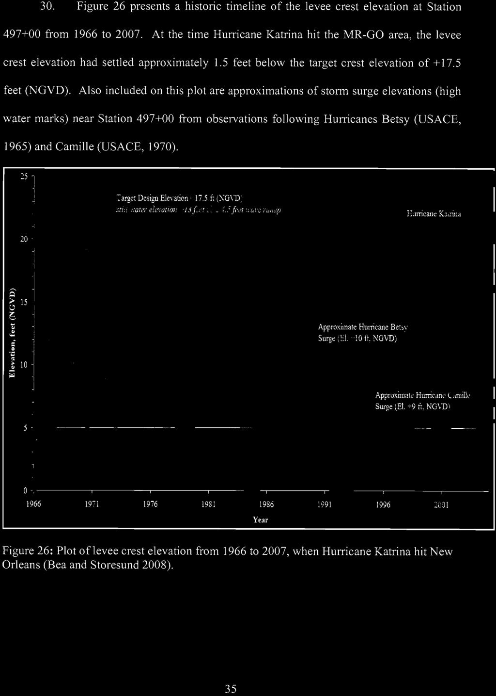
21 Case 2:05-cv SRD-JCW Document Filed 11/18/2009 Page 21 of 33 Graphic No 10.5A.


22 Case 2:05-cv SRD-JCW Document Filed 11/18/2009 Page 22 of 33 Graphic 10.5B.

23 Graphic Case 2:05-cv SRD-JCW No 11. Document Filed 11/18/2009 Page 23 of 33 Date : 27 January 2009 Subject : Comparison flood depth development between Katrina event and Scenario 2C From : ir. B. Maaskant, dr.ir. M. Kok To : Joe Bruno Comparison flood depth development between Katrina event and Scenario 2C The flooding of the bowls in New Orleans has been simulated with the use of the 1D2D flood simulation program SOBEK, see Kok et al. (2007). In that report three bowls have been distinguished, the Orleans Metro bowl, the New Orleans East bowl and the Saint Bernard bowl. For the three bowls flood simulations are constructed. Following on that report this memorandum will present the flood depth development over time for five specific locations. These locations are all situated in the Saint Bernard bowl (figure 1). In the table and picture below the five locations are shown. Table 1: The five considered locations X Y ELEV LATITUDE LONGITUDE LABEL ADDRESS ,06-2, ' 44.79" N 90 00' 10.35" W Norman Robinson 6965 Mayo Blvd ,02 1, ' 29.58" N 89 58' 29.07" W Kent Lattimore 2100 Marcelle Dr ,32 1, ' 31.20" N 89 58' 38.02" W Lattimore & Associates 9117 W Saint Bernard Hwy ,72 0, ' 00.75" N 89 56' 11.64" W Tanya Smith 3920 Despaux Dr ,53 0, ' 37.14" N 90 00' 46.21" W Lucille and Anthony Franz 5926 Saint Claude Ave Figure 1: Visual representation of the five locations Because the locations Lattimore & Associates and Kent Lattimore are close together and the 50 by 50 meter grid that is used in the simulations these two locations will be considered as one.
24 Case 2:05-cv SRD-JCW Document Filed 11/18/2009 Page 24 of 33 Graphic No. 12A. Flood simulations Greater New Orleans July 2007 In our model simulations no overtopping occurs before 7:00am, and the two breaches start at 7:00am. Therefore no water, except rain water, prior to 7:00am is visible inside the Lower 9 th Ward in the simulation results. ILIT gives an alternative explanation for the early water mentioned by eye witness reports in IPET. ILIT mentions under seepage, water migrating from the channel, under pressure, beneath the IHNC floodwalls as a possible explanation for the early flood water in the Lower 9 th Ward. Under seepage through a levee is not captured in the simulation :00h :30h :00h :30h 39
25 Graphic Case 2:05-cv SRD-JCW No. 12B. Document Filed 11/18/2009 Page 25 of 33 Flood simulations Greater New Orleans July :00h :30h :00h :30h :00h :00h 40

26 Graphic No. 12C. Case 2:05-cv SRD-JCW Document Filed 11/18/2009 Page 26 of 33 Flood simulations Greater New Orleans July :00h :00h Figure 5.2 Progressing snapshots of the computed internal flooding water depth inside the St. Bernard bowl Figure 5.2 shows the calculated maximum internal flooding depths in the St. Bernard bowl as a consequence of the breaches and overtopping initiated by hurricane Katrina. Figure 5.4 shows the comparison between our computed internal flood hydrographs and those presented by IPET for the St. Bernard bowl. The locations of the hydrographs are indicated in figure 5.1, location A corresponds with Lower 9th Ward NW., B with Lower 9th Ward E. and C with Chalmette. IPET based its hydrographs on eye witness accounts, stopped clock times and time/date stamped digital photographs. Our computed flood hydrographs are very similar to the data presented by IPET. The predicted peak flood level is within a foot of IPET s measurements. The peak in the model is a couple of hours earlier and the water level starts to decrease earlier than in the IPET hydrographs. The final water descent rate in the model is about equal to the IPET hydrograph. As discussed previously, in extreme events such as Katrina is difficult if not impossible to get direct measurement of some input data such as water levels at the time of a breach, especially right at the breach location. However, the differences between the computer model results and the calibration data are fully acceptable. For the purpose of this study the model results are very credible. 41
27 Case 2:05-cv SRD-JCW Document Filed 11/18/2009 Page 27 of 33 Graphic No. 13.


28 Case 2:05-cv SRD-JCW Document Filed 11/18/2009 Page 28 of 33 Graphic No. 14.
29 342' Graphic No. 15A. Case 2:05-cv SRD-JCW Document Filed 11/18/2009 Page 29 of ' ' 262' 266' 233' 314' 8 554' 505' 285' 437' 381' 1088' Bayou Bienvenue 18' 18' 18.5' 342' 226' 497' ' 847' 18' 393' 327' 1098' Legend 15' 16.5' 16.5' 17.5' 2, ,000 Feet 332' 391' 11.5' 17' 5.2' 266' 461' 6.4' 388' 11.5' 332' 13' 17' 13' 322' 395' 11' 1229' 11' 283' 446' 11.5' ' 306' 427' 1481' 364' 2673' 1279' 1143' Design Top of Channel 2005 Shoreline Levee Sheetpile/Wall Structures 10.0' Chad Morris Levee Breaches w/ Sill Elevations 15.0' Steven Fitzgerald Pre-Katrina Levee Heights Distance from Levee Toe* to 2005 Shoreline Duncan FitzGerald Channel Widening 12' 16.5' 8' 9.5' 355' 6.3' 9.3' ' 369' 6.5' 9.5' 423' 9' 288' 13' 8' 480' 330' 16' 346' 378' 57 7' 387' 333' 8' 638' 335' 536' 400' 434' 878' 977' East Bank West Bank *Levee toe delineated 50-feet from centerline of levee. 16' 16.2' 4.5' 8' 276' 5' 367' 352' 447' 747' 959' 56 GIS Data from: PX1818, PX1819, PX1820, PX1823, PX1825, PX1849, PX1851, PX1863; and S. Fitzgerald levee crest elevation from PX ' 39
30 Graphic No. 15B. Case 2:05-cv SRD-JCW Document Filed 11/18/2009 Page 30 of 33 8' 7' 10.5' 352' 447' 269' 9.5' 10.5' 56 10' 319' 387' 959' 280' 1770' 182' 17' 8.2' 16' 439' ' 10.5' 8' 383' 338' 381' 582' 333' 10.5' 9.5' 15.7' 371' 9' 12.5' 570' 134' 138' 1225' ' 257' 1029' 538' Legend 15.5' 2' 15.5' 2, ,000 Feet 177' 17' 9.5' 302' 412' 359' 8' 8' 367' 15.7' 738' 326' 393' 427' 289' 1060' ' 370' 573' 611' Design Top of Channel 2005 Shoreline Levee Sheetpile/Wall Structures 10.0' Chad Morris Levee Breaches w/ Sill Elevations 15.0' Steven Fitzgerald Pre-Katrina Levee Heights Distance from Levee Toe* to 2005 Shoreline Duncan FitzGerald Channel Widening 15.7' 11' 15.5' 345' 15.8' 12' 498' 215' 14.5' 12' 328' 12.5' 17' 387' 12' 568' 339' 14' 374' 653' 169' 546' 670' ' 342' 241' East Bank 17.3' 302' 133' 152' West Bank *Levee toe delineated 50-feet from centerline of levee. 18.5' ' 10' 10.5' 581' Bayou Dupre 128' 581' 270' 98' GIS Data from: PX1818, PX1819, PX1820, PX1823, PX1825, PX1849, PX1851, PX1863; and S. Fitzgerald levee crest elevation from PX ' 16' 40
31 Graphic No. 15C. Case 2:05-cv SRD-JCW Document Filed 11/18/2009 Page 31 of 33 98' 666 Bayou Dupre 16' 18' 12' 581' 10' 11' 270' 443' ' 111' 274' 8 429' 244' 305' 18.5' 11.5' 17.5' 11' 13.2' 469' 294' 420' 229' 363' 339' 18.5' 7.5' 11.5' 12' 17.5' 13.5' 141' 10.5' 488' 570' 12.5' 9.8' 13' 447' ' 238' 546' 702' 270' 500' 1118' 544' 439' Legend 2, ,000 Feet 18.5' 12.5' 13.7' 17' 14' 206' 503' 12.5' 191' 519' 216' 501' 495' 465' ' 958' 1943' Design Top of Channel 17.5' 14.8' 569' 155' 2005 Shoreline Levee Sheetpile/Wall Structures 17.5' 13.8' 13.5' 13.5' 567' 218' 503' 148' 337' 931' 10.0' Chad Morris Levee Breaches w/ Sill Elevations 572' 195' ' Steven Fitzgerald Pre-Katrina Levee Heights 18' 13' 13' 522' 264' 456' 198' Distance from Levee Toe* to 2005 Shoreline 17.5' 13' 524' Duncan FitzGerald Channel Widening East Bank 19' West Bank *Levee toe delineated 50-feet from centerline of levee. GIS Data from: PX1818, PX1819, PX1820, PX1823, PX1825, PX1849, PX1851, PX1863; and S. Fitzgerald levee crest elevation from PX
32 Graphic No. 15D. Case 2:05-cv SRD-JCW Document Filed 11/18/2009 Page 32 of ' 931' 337' ' 8 264' 223' 456' 198' 227' 524' 210' 178' 15' 510' 177' 853' 543' 225' 619' 18' 13' 498' 289' ' 1148' 17.4' 18.2' 13.5' 13.7' 13.5' 14' 13.2' 438' 285' 443' 377' 1265' 1564' 349' 432' ' 18.5' 295' 1742' 17' 399' 325' 359' 1125' 2, ,000 Feet 17' 366' ' 321' 531' 1021' 1259' Legend 15.5' 737' Design Top of Channel 2005 Shoreline 18.23' 533' 609' 688' ' 950' Levee Sheetpile/Wall Structures 559' 1427' 10.0' Chad Morris Levee Breaches w/ Sill Elevations 18.65' 790' 688' 15.0' Steven Fitzgerald Pre-Katrina Levee Heights 607' Distance from Levee Toe* to 2005 Shoreline 18.48' 487' Duncan FitzGerald Channel Widening East Bank 18.74' West Bank *Levee toe delineated 50-feet from centerline of levee. GIS Data from: PX1818, PX1819, PX1820, PX1823, PX1825, PX1849, PX1851, PX1863; and S. Fitzgerald levee crest elevation from PX

33 Case 2:05-cv SRD-JCW Document Filed 11/18/2009 Page 33 of 33 Graphic No. 16.
Expert Report. Robert Glenn Bea, Ph.D., P.E.
 Expert Report of Robert Glenn Bea, Ph.D., P.E. Prepared for Plaintiffs in: Katrina Canal Breaches Consolidated Litigation [Civil Action Number: 05-4182 K (2)] United States District Court Eastern District
Three-Dimensional Seepage Effects at Three New Orleans Levee Breaches During Hurricane Katrina
 Three-Dimensional Seepage Effects at Three New Orleans Levee Breaches During Hurricane Katrina Diego Cobos-Roa Graduate Student Department of Civil & Environmental Engineering University of California
Wetland attenuation of Hurricane Rita s storm surge
 Wetland attenuation of Hurricane Rita s storm surge Pat Fitzpatrick, Yee Lau, Yongzuo Li, Nam Tran, Chris Hill, and Suzanne Shean Geosystems Research Institute, Mississippi State University Sponsors: NOAA
CHAPTER SEVEN: THE NEW ORLEANS EAST PROTECTED AREA
 7.1 Introduction CHAPTER SEVEN: THE NEW ORLEANS EAST PROTECTED AREA The New Orleans East (NEO) protected area includes some of the lowest ground in the metropolitan region. Therefore, it is not surprising
How a Navigation Channel Contributed to Most of the Flooding of New Orleans During Hurricane Katrina
 Public Organiz Rev (2009) 9:291 308 DOI 10.1007/s11115-009-0093-8 How a Navigation Channel Contributed to Most of the Flooding of New Orleans During Hurricane Katrina Ivor Ll. van Heerden & G. Paul Kemp
US Army Corps of Engineers BUILDING STRONG
 Greater New Orleans Hurricane and Storm Damage Risk Reduction System Robert Rowlette Senior Senior Program Manager Task Force Hope U.S. Army Corps of Engineers April 19, 2012 US Army Corps of Engineers
Hurricane KATRINA Lessons Learned for Managing Risk
 Hurricane KATRINA Lessons Learned for Managing Risk Steven L. Stockton, P.E. Deputy Director of Civil Works U.S. Army Corps of Engineers What Happened? Storm Path from August 23 to 31, 2005 Mon. August
OSCILLATIONS OF SEMI-ENCLOSED WATER BODY INDUCED BY HURRICANES. Yuan-Hung Paul Tan 1 and Jiin-Jen Lee 1
 OSCILLATIONS OF SEMI-ENCLOSED WATER BODY INDUCED BY HURRICANES Yuan-Hung Paul Tan 1 and Jiin-Jen Lee 1 The primary focus of this research is to study the oscillations of semi-enclosed water body induced
Case 1:05-cv SGB Document Filed 11/12/13 Page 1 of 18
 Case 1:05-cv-01119-SGB Document 241-14 Filed 11/12/13 Page 1 of 18 Table of Contents Purpose of the Study Principal Findings Expert Background and Qualifications ADCIRC Models ADCIRC Models for Southern
SCOUR CHARACTERIZATION DUE TO WATER FREE FALL
 SCOUR CHARACTERIZATION DUE TO WATER FREE FALL Abdolreza Osouli, Corresponding Author, Ph.D., P.E. Assistant Professor of Civil Engineering, Southern Illinois University at Edwardsville, Engineering Building,
CHAPTER SIX: THE ST. BERNARD AND LOWER NINTH WARD PROTECTED AREA
 CHAPTER SIX: THE ST. BERNARD AND LOWER NINTH WARD PROTECTED AREA 6.1 Introduction As described previously in Chapter 2, St. Bernard Parish and the Lower Ninth Ward are protected by a single continuous
CHAPTER FIVE: THE LOWER MISSISSIPPI REGION AND PLAQUEMINES PARISH
 CHAPTER FIVE: THE LOWER MISSISSIPPI REGION AND PLAQUEMINES PARISH 5.1 Overview Plaquemines Parish is the area where the last portion of the Mississippi River flows out into the Gulf of Mexico (see Figures
Greater New Orleans Hurricane and Storm Damage Risk Reduction System 101
 Greater New Orleans Hurricane and Storm Damage Risk Reduction System 101 René Poché New Orleans District U.S. Army Corps of Engineers US Army Corps of Engineers BUILDING STRONG 1878 Gentilly Ridge Metairie
Hurricane Tracks. Isaac versus previous storms Impacts and solutions. ( Continue by clicking on the slide bar to the right)
") Hurricane Tracks Isaac versus previous storms Impacts and solutions ( Continue by clicking on the slide bar to the right) 1 Hurricane Tracks 2 Sample Hurricanes The sample hurricanes selected were chosen
Hurricane Tracks Isaac versus previous storms Impacts and solutions ( Continue by clicking on the slide bar to the right) 1 Hurricane Tracks 2 Sample Hurricanes The sample hurricanes selected were chosen
Fil Failure Analysis of fthe Breached Levee System at the 17th Street Canal, New Orleans
 Fil Failure Analysis of fthe Breached hd Levee System at the 17th Street Canal, New Orleans Jay Wang, Ph.D., P.E. Department of Civil Engineering and Construction Engineering Technology Louisiana Tech
Lab 12 Coastal Geology
 Lab 12 Coastal Geology I. Fluvial Systems Hydrologic Cycle Runoff that flows into rivers = precipitation (rain and snowmelt) [infiltration (loss to groundwater) + evaporation (loss to atmosphere) + transpiration
Appendix A STORM SURGE AND WAVE HEIGHT ANALYSIS
 Appendix A STORM SURGE AND WAVE HEIGHT ANALYSIS Memo To: Jeff Robinson, P.E., GEC, Inc. From: Silong Lu, Ph.D., P.E., D.WRE, Dynamic Solutions, LLC. Date: 1/9/2014 CC: Re: Chris Wallen, Vice President,
RESULTS FROM THE TEXAS COASTAL SEDIMENT SOURCES: A GENERAL EVALUATION STUDY
 RESULTS FROM THE TEXAS COASTAL SEDIMENT SOURCES: A GENERAL EVALUATION STUDY JUAN MOYA KELSEY CALVEZ CRIS WEBER ANTHONY RISKO *KEVIN FRENZEL FREESE AND NICHOLS, INC. COASTAL AND WATERWAYS GROUP OBJECTIVES
Lessons Learned from Analysis of the New Orleans Hurricane Protection System
 Lessons Learned from Analysis of the New Orleans Hurricane Protection System By Interagency Performance Evaluation Task Force Reported by Michael K. Sharp ABSTRACT This report, Performance Evaluation of
Armstrong Case Judgement and Findings of Fact.PDF
 April 12, 2013 Dr. W. Allen Marr, Founder and CEO of Geocomp Corporation, provided pivotal expert witness testimony in the long-standing Hurricane Katrina litigation known as the Armstrong case, which
Laboratory Exercise #3 The Hydrologic Cycle and Running Water Processes
 Laboratory Exercise #3 The Hydrologic Cycle and Running Water Processes page - 1 Section A - The Hydrologic Cycle Figure 1 illustrates the hydrologic cycle which quantifies how water is cycled throughout
HORIZONTAL TRANSLATIONAL FAILURES OF LEVEES DUE TO WATER FILLED GAPS
 HORIZONTAL TRANSLATIONAL FAILURES OF LEVEES DUE TO WATER FILLED GAPS Dr. Meindert A. Van Dr. Cor Zwanenburg John M. van Esch Deltares Deltares Deltares and Delft University of Delft, The Netherlands Delft,
Appendix 15 Computational Methodology
 Appendix 15 Computational Methodology Introduction This Appendix describes the process used by the risk team to determine the final loss exceedence values in the risk analysis. The process involved the
Improvements to Southeast Louisiana s floodwalls and pump stations since Katrina: the Hurricane and Storm Damage Risk Reduction System (HSDRRS)
") Improvements to Southeast Louisiana s floodwalls and pump stations since Katrina: the Hurricane and Storm Damage Risk Reduction System (HSDRRS) Pat Fitzpatrick Mississippi State University Review of levee
Improvements to Southeast Louisiana s floodwalls and pump stations since Katrina: the Hurricane and Storm Damage Risk Reduction System (HSDRRS) Pat Fitzpatrick Mississippi State University Review of levee
The Stability of Flood Defenses on Permeable Soils: The London Avenue Canal Failures in New Orleans
 Missouri University of Science and Technology Scholars' Mine International Conference on Case Histories in Geotechnical Engineering (2008) - Sixth International Conference on Case Histories in Geotechnical
ΛTKINS. Applications of Regional Sediment Management Concepts in Texas Estuarine Restoration Projects. Riparian Workshop Fort Worth, October 17, 2012
 Juan C Moya, PhD., PG Coastal Planning and Restoration Applications of Regional Sediment Management Concepts in Texas Estuarine Restoration Projects Riparian Workshop Fort Worth, October 17, 2012 West
Geotechnical Challenges New Orleans USACE
 35 th Southwest Geotechnical Engineering Conference Geotechnical Challenges New Orleans USACE Mark Woodward, PE Jehu Johnson, EI Geotechnical Branch New Orleans District 28 April 2010 Slide 1 New Orleans
PART 4 GEOLOGIC SETTING AND FOUNDATION CONDITIONS IN NEW ORLEANS
 PART 4 GEOLOGIC SETTING AND FOUNDATION CONDITIONS IN NEW ORLEANS The modern Mississippi Delta has been deposited during the past 6000 years, in four major areas. Current interpretation of the modern delta.
Appendix 9 Risk Methodology
 Appendix 9 Risk Methodology Introduction This Appendix describes the risk analysis philosophy and methodology used to evaluate the performance of the New Orleans hurricane protection system. Probabilistic
Hurricanes and Storm Surge : Before coming to lab, visit the following web site:
 Geol 108 Lab #7 Week of October 15-19, 2012 Coastal Studies Hurricanes and Storm Surge : Before coming to lab, visit the following web site: http://www.usatoday.com/graphics/weather/gra/gsurge/flash.htm
PART 5 MECHANISMS OF GROUND SETTLEMENT IN GREATER NEW ORLEANS
 PART 5 MECHANISMS OF GROUND SETTLEMENT IN GREATER NEW ORLEANS Predicted water depth in New Orleans flood inundation area based on water level of 2.37 ft in Lake Ponchartrain on Sept 2, 2005. Overlay on
Probabilistic design of levee and floodwall heights for the Hurricane Protection System in the New Orleans area
 Probabilistic design of levee and floodwall heights for the Hurricane Protection System in the New Orleans area Mathijs van Ledden (Haskoning Inc.), Pat Lynett (Texas A&M), Don Resio (ERDC) and Nancy Powell
Performance Evaluation of the New Orleans and Southeast Louisiana Hurricane Protection System
 Performance Evaluation of the New Orleans and Southeast Louisiana Hurricane Protection System Final Report of the Interagency Performance Evaluation Task Force Volume V The Performance Levees and Floodwalls
An analysis of storm surge attenuation by wetlands using USGS, FEMA, and NASA data
 An analysis of storm surge attenuation by wetlands using USGS, FEMA, and NASA data Pat Fitzpatrick Geosystems Research Institute Mississippi State University Walter Peterson and Courtney Buckley NASA Marshall
MISSISSIPPI RIVER DELTA OVERVIEW
 MISSISSIPPI RIVER DELTA OVERVIEW Science and Engineering Special Team Conference Louisiana State University October 9, 2012 Introduction Basics of the Mississippi Delta Natural and Human-Induced Land Loss
West Galveston Bay Regional Sediment Management Plan (An Eco-geomorphologic Approach)
") West Galveston Bay Regional Sediment Management Plan (An Eco-geomorphologic Approach) Juan Moya, Matthew Mahoney and Mike Smith Restore America s Estuaries Conference Tampa, FL, October 23, 2012 Atkins
West Galveston Bay Regional Sediment Management Plan (An Eco-geomorphologic Approach) Juan Moya, Matthew Mahoney and Mike Smith Restore America s Estuaries Conference Tampa, FL, October 23, 2012 Atkins
Appendix 10 Reliability Modeling
 Appendix 10 Reliability Modeling Reliability analysis is that part of the risk study that leads to an evaluation of the conditional probability of failure (i.e., reliability or fragility) of structures,
Regional Sediment Management
 Regional Sediment Management Linda S. Lillycrop Program Manager Coastal Engineer US Army Engineer Research and Development Center Coastal and Hydraulics Laboratory Q AVG Coastal Resilience: The Environmental,
New Orleans Levee System Performance during Hurricane Katrina: London Avenue and Orleans Canal South
 New Orleans Levee System Performance during Hurricane Katrina: London Avenue and Orleans Canal South Javier Ubilla, M.ASCE 1 ; Tarek Abdoun, M.ASCE 2 ; Inthuorn Sasanakul, M.ASCE 3 ; Michael Sharp, M.ASCE
MODELLING CATASTROPHIC COASTAL FLOOD RISKS AROUND THE WORLD
 MODELLING CATASTROPHIC COASTAL FLOOD RISKS AROUND THE WORLD Nicola Howe Christopher Thomas Copyright 2016 Risk Management Solutions, Inc. All Rights Reserved. June 27, 2016 1 OUTLINE MOTIVATION What we
BUNCOMBE COUNTY NORTH CAROLINA
 PROJECT SITE ² 0 0. 75 1. 5 LOCATION MAP MARCH 2018 2. 25 3 Mil es AID: PROJECT # 2018-01122 18.05301 Sheet 1 of 7 Sources: Esri, HERE, DeLorme, USGS, Intermap, INCREMENT P, NRCan, Esri Japan, METI, Esri
Redwood City Harbor, California, Navigation Improvement Feasibility Study. Appendix D. Geotechnical Engineering. DRAFT April 2015
 1 Redwood City Harbor, California, Navigation Improvement Feasibility Study Appendix D Geotechnical Engineering DRAFT April 2015 2 Contents 1 Purposes of Report... 3 2 Background... 3 3 References and
Project (Project No. US-CA-62-2) Maintenance Inspection and Reports (Subtask 14.1) Inspection Report No.2
 Maintenance Inspection and Reports (Subtask 14.1) Inspection Report No.2") MEMORANDUM TO: FROM: Jim Well, Ducks Unlimited Mike Harvey, PhD, PG SUBJECT: M&T/ Llano Seco Fish Screen Project (Project No. US-CA-62-2) Maintenance Inspection and Reports (Subtask 14.1) Inspection Report
MEMORANDUM TO: FROM: Jim Well, Ducks Unlimited Mike Harvey, PhD, PG SUBJECT: M&T/ Llano Seco Fish Screen Project (Project No. US-CA-62-2) Maintenance Inspection and Reports (Subtask 14.1) Inspection Report
Benchmarking of Hydrodynamic Models for Development of a Coupled Storm Surge Hazard-Infrastructure Modeling Method to improve Inundation Forecasting
 Benchmarking of Hydrodynamic Models for Development of a Coupled Storm Surge Hazard-Infrastructure Modeling Method to improve Inundation Forecasting Abstract Fragility-based models currently used in coastal
Dam Break Analysis Using HEC-RAS and HEC-GeoRAS A Case Study of Ajwa Reservoir
 Journal of Water Resources and Ocean Science 2016; 5(6): 108-113 http://www.sciencepublishinggroup.com/j/wros doi: 10.11648/j.wros.20160506.15 ISSN: 2328-7969 (Print); ISSN: 2328-7993 (Online) Case Report
Comparative Analysis of Hurricane Vulnerability in New Orleans and Baton Rouge. Dr. Marc Levitan LSU Hurricane Center. April 2003
 Comparative Analysis of Hurricane Vulnerability in New Orleans and Baton Rouge Dr. Marc Levitan LSU Hurricane Center April 2003 In order to compare hurricane vulnerability of facilities located in different
PART 4 HURRICANE KATRINA STRIKES NEW ORLEANS AUGUST 2005
 PART 4 HURRICANE KATRINA STRIKES NEW ORLEANS AUGUST 2005 Hurricane Katrina Hurricane Katrina swept across southern Florida and lost momentum, then gained speed and water, showing the second lowest barometric
MEMORANDUM 1. INTRODUCTION
 MEMORANDUM TO: Jim Well, Ducks Unlimited FROM: Mike Harvey, PhD, PG, Bob Mussetter, PhD, PE, Dai Thomas, PE SUBJECT: Two-dimensional Sediment-transport Modeling of the M&T/Llano Project No. US-CA-62-2
APPENDIX B: BORING LOGS
 New Orleans Levee Systems Independent Levee Hurricane Katrina Investigation Team July, 6 APPENDIX B: BORING S As part of the field investigation 9 borings were performed at the sites of interest, as listed
GIS 2010: Coastal Erosion in Mississippi Delta
 1) Introduction Problem overview To what extent do large storm events play in coastal erosion rates, and what is the rate at which coastal erosion is occurring in sediment starved portions of the Mississippi
Technical Memorandum No Sediment Model
 Pajaro River Watershed Study in association with Technical Memorandum No. 1.2.9 Sediment Model Task: Development of Sediment Model To: PRWFPA Staff Working Group Prepared by: Gregory Morris and Elsie Parrilla
3.0 ROBERTS BANK TIDAL FLAT MORPHOLOGY
 Vancouver Port Authority Northwest Hydraulic Consultants Ltd. /Triton Consultants Ltd. Roberts Bank Container Expansion File: 33863 Coastal Geomorphology Study - 19 - November 2004 3.0 ROBERTS BANK TIDAL
East Branch Grand Calumet River Great Lakes Legacy Act Sediment Remediation and Restoration Project
 East Branch Grand Calumet River Great Lakes Legacy Act Sediment Remediation and Restoration Project Jointly funded by the U.S. EPA Great Lakes Legacy Act, Indiana Department of Environmental Management
MRGO Rock Dam Survey at Bayou la Loutre
 MRGO Rock Dam Survey at Survey conducted May 6, 2009 Report released May 18, 2009 By John Lopez, Ph.D. Coastal Sustainability Program Lake Pontchartrain Basin Foundation Final Print Legal size 1 of 13
Exhibit RMP-4. Foote Creek Geology and Topography
 Exhibit RMP-4 Foote Creek Geology and Topography Memorandum To: From: CC: Travis Brown, PacifiCorp Daria Drago, P.E., PMP Dr. Deb Luchsinger Date: January 9, 2019 Re: Foote Creek Rim 1 - Geologic Conditions
Hurricane Katrina and Oil Spills: Impact on Coastal and Ocean Environments
 Archived version from NCDOCKS Institutional Repository http://libres.uncg.edu/ir/asu/ Pine, J. C. (June 2006). Hurricane Katrina and oil spills: Impact on coastal and ocean environments. Oceanography,
Appendix I. Dredged Volume Estimates. Draft Contractor Document: Subject to Continuing Agency Review
 Appendix I Dredged Volume Estimates Draft Contractor Document: Subject to Continuing Agency Review Interoffice Correspondence Date: April 6, 2007 To: L. Bossi (WHI) Copy: S. Thompson (WHI), B. Fidler (NNJ)
Key Processes
 Data Manipulation and Extraction Key Processes Key Processes Re-Projecting Data Selecting by Attributes Exporting Data Hillshade Reclassification Conversion of Raster to Vector Re-Projecting Data Purpose
Report on the Damage Survey Caused by Hurricane Katrina (Tentative Report)
") Report on the Damage Survey Caused by Hurricane Katrina (Tentative Report) November 1, 2005 Coastal Disaster Prevention Technology Survey Team 1. Introduction Hurricane Katrina struck the United States
Report on the Damage Survey Caused by Hurricane Katrina (Tentative Report) November 1, 2005 Coastal Disaster Prevention Technology Survey Team 1. Introduction Hurricane Katrina struck the United States
FUTURE MEANDER BEND MIGRATION AND FLOODPLAIN DEVELOPMENT PATTERNS NEAR RIVER MILES 200 TO 191 OF THE SACRAMENTO RIVER PHASE III REPORT
 FUTURE MEANDER BEND MIGRATION AND FLOODPLAIN DEVELOPMENT PATTERNS NEAR RIVER MILES 200 TO 191 OF THE SACRAMENTO RIVER PHASE III REPORT Eric W. Larsen REPORT FOR DUCKS UNLIMITED March 31, 2006-1 - Contents
MEANDER MIGRATION MODEL ASSESSMENT FOR THE JANUARY 2005 STORM, WHITMAN PROPERTY, SAN ANTONIO CREEK, VENTURA COUNTY, CALIFORNIA
 MEANDER MIGRATION MODEL ASSESSMENT FOR THE JANUARY 2005 STORM, WHITMAN PROPERTY, SAN ANTONIO CREEK, VENTURA COUNTY, CALIFORNIA Prepared by Eric Larsen, Ph.D. Mark Rains, Ph.D. October 2006 INTRODUCTION
Remote Sensing / GIS Conference. The Louisiana Proposed Elevation for the Nation Business Plan Components
 Remote Sensing / GIS Conference 08 April 2008 The Louisiana Proposed Elevation for the Nation Business Plan Components David Gisclair, Louisiana Oil Spill Coordinators Office, Office of the Governor david.gisclair@la.gov
The Mississippi River: Its Role in Restoration Efforts and Potential Effects of Climate Change
 The Mississippi River: Its Role in Restoration Efforts and Potential Effects of Climate Change Clinton S. Willson, P.E., Ph.D. Department of Civil & Environmental Engineering Louisiana State University
Programmatic Approaches to Assessing and Mitigating Risk to Pipelines from Natural Forces
 Programmatic Approaches to Assessing and Mitigating Risk to Pipelines from Natural Forces 23 rd International Petroleum Environmental Conference New Orleans, Louisiana November 8-10, 2016 Introduction
Donald K. Stauble and Bill Birkemeier Coastal and Hydraulics Laboratory US Army Corps of Engineers
 Donald K. Stauble and Bill Birkemeier Coastal and Hydraulics Laboratory US Army Corps of Engineers Define the Problem Navigation Shore Protection Environmental Political So what is the problem? Management
Geotechnical Reconnaissance of the Mississippi River Delta Flood-protection System After Hurricane Katrina
 Geotechnical Reconnaissance of the Mississippi River Delta Flood-protection System fter Hurricane Katrina y Ronaldo Luna, David Summers, David Hoffman, J. David Rogers, dam Sevi, and Emitt C. Witt This
1 INTRODUCTION AND MAJOR FINDINGS... 1
 Memorandum To: Lindsey Clark, Stillwater Valley Watershed Council Coordinator From: Chad Raisland, Pioneer Technical Services, Inc. and Karin Boyd, Applied Geomorphology, Inc. CC: Tanya Lester, Stillwater
Name: Date: Class: Louisiana: Our History, Our Home Chapter 1: Louisiana s Geography - Section 2: Natural Regions Guided Reading
 Instructions: Read the section and complete each item with words from the passages in this section. 1. The diversity of Louisiana s can surprise residents and visitors alike. 2. Physical geography is concerned
SHORELINE PROTECTION & RESTORATION PROGRAM
 City of Mandeville, LA SHORELINE PROTECTION & RESTORATION PROGRAM June 8, 2017 Pre-Budget Background Presentation Prepared by: Overview Background Context: RSLR, Rigolets Closure City Program & Project
NAME DATE TOPOGRAPHIC MAPS. Activity 1: Topographic Map Investigation I: More Than a Road Map
 NAME DATE PARTNER(S) TOPOGRAPHIC MAPS Now you have seen how topographic maps can be generated to present the elevation of a terrain. Let s look at some topographic maps and learn how to interpret them.
Annual transport rates at two locations on the fore-slope.
 Sediment Transport by Currents Fore-slope Sediment transport rates and sediment concentrations were computed from the hydrodynamic model runs as well as from direct measurements of current velocities at
THC-T-2013 Conference & Exhibition
 Modeling of Shutter Coastal Protection against Storm Surge for Galveston Bay C. Vipulanandan, Ph.D., P.E., Y. Jeannot Ahossin Guezo and and B. Basirat Texas Hurricane Center for Innovative Technology (THC-IT)
Highland Lake Bathymetric Survey
 Highland Lake Bathymetric Survey Final Report, Prepared For: The Town of Highland Lake 612 Lakeshore Drive Oneonta, AL 35121 Prepared By: Tetra Tech 2110 Powers Ferry Road SE Suite 202 Atlanta, GA 30339
Technical Memorandum No
 Pajaro River Watershed Study in association with Technical Memorandum No. 1.2.10 Task: Evaluation of Four Watershed Conditions - Sediment To: PRWFPA Staff Working Group Prepared by: Gregory Morris and
Summary of Hydraulic and Sediment-transport. Analysis of Residual Sediment: Alternatives for the San Clemente Dam Removal/Retrofit Project,
 Appendix N SUMMARY OF HYDRAULIC AND SEDIMENT-TRANSPORT ANALYSIS OF RESIDUAL SEDIMENT: ALTERNATIVES FOR THE SAN CLEMENTE DAM REMOVAL/RETROFIT PROJECT, CALIFORNIA the San Clemente Dam Removal/Retrofit Project,
Regional-scale understanding of the geologic character and sand resources of the Atlantic inner continental shelf, Maine to Virginia
 Regional-scale understanding of the geologic character and sand resources of the Atlantic inner continental shelf, Maine to Virginia Workshop on Dredging, Beach Nourishment and Bird Conservation Atlantic
MaxDepth Aquatics, Inc.
 MaxDepth Aquatics, Inc. Bathymetry of Mirror Pond From Newport Bridge to Galveston Bridge Prepared for the City of Bend By Joseph Eilers & Benn Eilers MaxDepth Aquatics, Inc. Bend, OR June 2005 INTRODUCTION
Floods Lecture #21 20
 Floods 20 Lecture #21 What Is a Flood? Def: high discharge event along a river! Due to heavy rain or snow-melt During a flood, a river:! Erodes channel o Deeper & wider! Overflows channel o Deposits sediment
THE IMPORTANCE OF SCIENCE IN COASTAL RESTORATION IN LOUISIANA
 THE IMPORTANCE OF SCIENCE IN COASTAL RESTORATION IN LOUISIANA Barb Kleiss USACE, Mississippi Valley Division August 3, 2011 LCA S&T Office Authorized under WRDA 2007 Designed to address technical issues
The Pontchartrain Maurepas Surge Consortium (LPMSC) Lake Sloshing Effect Preliminary Findings
 Lake Sloshing Effect Preliminary Findings") The Pontchartrain Maurepas Surge Consortium (LPMSC) Lake Sloshing Effect Preliminary Findings Lake Pontchartrain Basin Foundation John A. Lopez, Ph.D. with contributions from Dr. Joe Suhayda, Dr. Hal Needham,
The Pontchartrain Maurepas Surge Consortium (LPMSC) Lake Sloshing Effect Preliminary Findings Lake Pontchartrain Basin Foundation John A. Lopez, Ph.D. with contributions from Dr. Joe Suhayda, Dr. Hal Needham,
ES 105 Surface Processes I. Hydrologic cycle A. Distribution % in oceans 2. >3% surface water a. +99% surface water in glaciers b.
 ES 105 Surface Processes I. Hydrologic cycle A. Distribution 1. +97% in oceans 2. >3% surface water a. +99% surface water in glaciers b. >1/3% liquid, fresh water in streams and lakes~1/10,000 of water
CAUSES FOR CHANGE IN STREAM-CHANNEL MORPHOLOGY
 CAUSES FOR CHANGE IN STREAM-CHANNEL MORPHOLOGY Chad A. Whaley, Department of Earth Sciences, University of South Alabama, MobileAL, 36688. E-MAIL: caw408@jaguar1.usouthal.edu The ultimate goal of this
Unchain the River and Allow it to Build a Delta
 Unchain the River and Allow it to Build a Delta Harley S. Winer Atkins Harley.Winer@atkinsglobal.com Mississippi River Drainage Basin Basin Facts Drains 41% of continental U.S. Includes 31 states & 2 Canadian
Lab 13: Fluvial Processes and Landforms
 Name: Lab 13: Fluvial Processes and Landforms Geomorphology is the study of Earth s surface and of the processes acting to shape it. Streams, for example, are significant continental land-shaping agents.
Tenmile Lakes Delta Building Study
 Tenmile Lakes Delta Building Study Since the late 1940 s, Tenmile Lakes has seen a sharp increase in sediment accumulation at the mouths of the tributaries that feed the lake. To monitor this sediment
PHYSICAL GEOGRAPHY. By Brett Lucas
 PHYSICAL GEOGRAPHY By Brett Lucas FLUVIAL PROCESSES Fluvial Processes The Impact of Fluvial Processes on the Landscape Streams and Stream Systems Stream Channels Structural Relationships The Shaping and
Vermont Stream Geomorphic Assessment. Appendix E. River Corridor Delineation Process. VT Agency of Natural Resources. April, E0 - April, 2004
 Vermont Stream Geomorphic Assessment Appendix E River Corridor Delineation Process Vermont Agency of Natural Resources - E0 - River Corridor Delineation Process Purpose A stream and river corridor delineation
Hurricane Surge Hazard Analysis for Southeast Louisiana
 Hurricane Surge Hazard Analysis for Southeast Louisiana SLFPA-E Coastal Advisory Committee and Invitees February 21, 2013 Presented by Bob Jacobsen PE, LLC Consulting Coastal Hydrologist Objective Review
Water Level Statistics for Design of Transportation Facilities in Coastal Louisiana
 64 TRANSPORTATION RESEARCH RECORD 1483 Water Level Statistics for Design of Transportation Facilities in Coastal Louisiana JOSEPH SUtJAYDA, MOHAMED ALAWADY, AND BABAK NAGHAVI Results are presented of an
 Red River Flooding June 2015 Caddo and Bossier Parishes Presented by: Flood Technical Committee Where the Rain Falls Matters I-30 versus I-20 I-20 Backwater and Tributary Floods (Localized) 2016 Flood
Bank Erosion and Morphology of the Kaskaskia River
 Bank Erosion and Morphology of the Kaskaskia River US Army Corps Of Engineers St. Louis District Fayette County Soil and Water Conservation District Team Partners : Carlyle Lake Ecosystem Partnership Vicinity
Hydrographical Surveying of the Subaqueous Delta Plain of the River Rhine at Lake Constance
 Hydrographical Surveying of the Subaqueous Delta Plain of the River Rhine at Lake Constance Erwin Heine Institute of Surveying BOKU University Vienna, AUSTRIA Content Introduction Universität für Bodenkultur
LOMR SUBMITTAL LOWER NEHALEM RIVER TILLAMOOK COUNTY, OREGON
 LOMR SUBMITTAL LOWER NEHALEM RIVER TILLAMOOK COUNTY, OREGON Prepared for: TILLAMOOK COUNTY DEPARTMENT OF COMMUNITY DEVELOPMENT 1510-B THIRD STREET TILLAMOOK, OR 97141 Prepared by: 10300 SW GREENBURG ROAD,
Smart Flood Risk Management Solutions
 Smart Flood Risk Management Solutions - RHDHV s Experience in the Gulf of Mexico Mathijs van Ledden, Marten Hillen and Ries Kluskens Challenge Extreme weather around the world (hurricanes, cyclones, extratropical
Coastal Emergency Risks Assessment - CERA Real-Time Storm Surge and Wave Visualization Tool
 Coastal Emergency Risks Assessment - CERA Real-Time Storm Surge and Wave Visualization Tool Introduction This document provides guidance for using the Coastal Emergency Risks Assessment (CERA) visualization
Red River Levee Panel
 Red River Levee Panel Mississippi River Commission Monday, August 9, 2017 Red River Levees in LA & AR NONE along TX & OK Boarder Red River Levee Issues Caddo Levee Cherokee Park Authorization Bossier Levee
Mapping the River as it Reconnects with Its Delta: Field Studies in Big Mar and Bohemia
 Mapping the River as it Reconnects with Its Delta: Field Studies in Big Mar and Bohemia Ezra Boyd, John Lopez, Andy Baker, Theryn Henkel Lake Pontchartrain Basin Foundation Coastal Sustainability Program
Coastal Litigation in the Context of Science Literacy
 Coastal Litigation in the Context of Science Literacy Chris McLindon New Orleans Geological Society February 6, 7 Science Literacy The value of community participation in scientific research is widely
Quantifying i the GLRI Metric for Annual Sediment Deposition in Great Lakes Harbors:
 USACE 516(e) Annual Meeting Ann Arbor, MI (May 15, 2013) Quantifying i the GLRI Metric for Annual Sediment Deposition in Great Lakes Harbors: A Pilot Evaluation for Toledo Harbor Todd Redder Joe DePinto
Appendix D. Sediment Texture and Other Soil Data
 5 6 7 8 Appendix D. Sediment Texture and Other Soil Data This appendix describes the sediment texture of the aquifer system in the Restoration Area. The contents of this appendix describe the: Importance