CHAPTER 6 SEISMIC STRATIGRAPHY AND GROSS DEPOSITIONAL ENVIRONMENT MAPPING
|
|
|
- Kristin Reeves
- 5 years ago
- Views:
Transcription
1 CHAPTER 6 SEISMIC STRATIGRAPHY AND GROSS DEPOSITIONAL ENVIRONMENT MAPPING
2
3 CHAPTER 6.1 SEISMIC STRATIGRAPHY
4

5 SEISMIC STRATIGRAPHY 83 MGR c 83 MGR ab TGS Transect 1 83 MGR c TGS 221b-100 TGS Transect 3 COB COB 83 MGR a Oblique line Veritas cube Oblique line Veritas cubeoblique line Veritas cube 83 MGR ba TGS Transect 2 COB These three dip sections across the Sable Sub-basin illustrate the variability and complexity in structural and sedimentary architecture of the Central Scotian Margin since the Breakup Unconformity (J200). Salt tectonics is the key feature as it controls the majority of the faulting systems, as well as sediment distribution and the resulting architecture. The main structures observed are: Growth faults system rooted to the top of salts; Synkinematic wedges (Transects 1 and 2) characterized by extension in the upper part and compression in the downward part (rafted structures, turtle back structures); A roho system with autochthonous salt feeders (Transect 1); Salt canopy in Transects 1 and 2 as well as diapirs in Transect 3. Transect 1 shows a large extension of the autochthonous salt, which tends to decrease northeast of Transect 3. Decreases in the size of the salt basin coincides with changes in salt tectonic styles, with changes occurring rapidly along the 200 km of the study area. The southwestern part of the area, which is represented by Transect 1, shows Cretaceous age fishbone architectures and a Roho system. Toward the central part of the Sub-basin, the extent of the autochthonous salt decreases and the area is characterized by a deeply rooted growth fault system. Vertical sediment movement is significant, and the associated deformation generates major structures, such as in Glenelg J-48, or large a vertical space for sediment accommodation, such as that found between Glenelg J-48 and Annapolis G- 34. To the northeast, the salt extent is reduced to the back of the Alma Ridge (Transect 3). The main structure corresponds to the Banquereau Synkinematic Wedge (BSW): its internal structure shows landward tilted blocks. The BSW is related to the collapse of the margin during the Jurassic due to the migration of the autochthonous salt over the Alma Ridge (Deptuck et al., 2014). Post Jurassic deformation is related to mechanical readjustment of the BSW in response to sediment loading during the Early to Mid Cretaceous, but this part of the basin does not show the same complexity as other parts of the study area. Additionally, the deformation across the margin is passively controlled by large structures inherited from the rifting, such as the Alma Ridge, and the main growth faults always develop in association with these prominent regional structures. In summary, the study area is divided into three distinct structural zones. It appears that where the autochthonous salt is more extensive, the deformation is more complex and therefore numerous trapping systems are created. In the Annapolis area where the salt is more restricted, deformation is more localized creating small deep basins. To the northeast in proximity to the BSW deformation is less developed because of the limited amount of salt and (except for the BSW itself), geometries are smoother and longer wavelength, leading to fewer trapping systems. Seismic Transects PL

, rifting ceases and the Scotian Margin begins to Subside. Salt deposited in the rifted Sable Subbasin starts to be overloaded by Jurassic sediment.")
6 SEISMIC STRATIGRAPHY 83 MGR c 83 MGR ab TGS Transect 1 83 MGR c TGS 221b-100 TGS Transect 3 COB COB 83 MGR a Oblique line Veritas cube Oblique line Veritas cube Oblique line Veritas cube 83 MGR ba TGS Transect 2 These three sections show the typical chronostratigraphic succession of the Sable Sub-basin. The deepest part of the sections shows the autochthonous salt identified above the basement and early syn-rift sediments. At the Early Jurassic (200 Ma), rifting ceases and the Scotian Margin begins to Subside. Salt deposited in the rifted Sable Subbasin starts to be overloaded by Jurassic sediment. The three dip sections show thick Jurassic succession on the shelf, but sediment thickness varies basinward, with a thicker offshore accumulation in the Balvenie area (Transect 1) and a decreasing trend to the Banquereau area (Transect 3). This difference is the result of the impact of the Alma Ridge, which prevents sediment from reaching the deepest part of the basin and forces sediment toward Annapolis and Balvenie areas (see also thickness maps Appendixes and 2.4.9). Between the Callovian and Tithonian interval (J163 J150), autochthonous salt starts to migrate over the Alma Ridge as sediment piles up on the back side of the Sub-basin. This rapid change in salt behavior coincides with the loading of Mic-Mac sediment in the area. Salt migration over the Ridge occurs within a very short time (much less than 7 MY), and leads to the creation of the Banquereau Synkinematic Wedge (BSW). A particular aspect of the event is that it duplicated the Lower to Middle Jurassic sequences, giving the illusion of a particularly thick Jurassic accumulation (Transect 3; see also PL for a mechanical reconstitution of the event). COB Salt deformation across the study area is diachronous. In the Balvenie and Annapolis areas, salt deformation starts at the end of the Jurassic and intensifies shortly after the base Cretaceous unconformity (K137). The increase in salt deformation coincides with deposition of the thick Missisauga Fm. Cretaceous successions are thicker in the Balvenie and Annapolis areas than in the Banquereau area, particularly the Barremian Albian interval (K130 K101). In Banquereau area, post BSW mechanical adjustment allows the accumulation of a thick Valanginian Hauterivian (K137 K130) interval against the main listric fault. However, overall the Cretaceous successions remain less important there than in the Annapolis and Balvenie areas. Salt canopies start to form during the Aptian and last until the Albian early Cenomanian. In the meantime, in the Balvenie area, a large roho system develops. Development of salt canopies during the Albian early Cenomanian coincides with the Logan Canyon Fm. The significant sediment loading over the salt canopy leads to the formation of numerous short lived intra salt minibasins. In the Banquereau area, sedimentation is only impacted by vertical migration of salt diapirs. Post Cenomanian, salt deformation decreases but continues until the Ypresian. The deformation is marked primarily in the salt canopy area and is much reduced on the shelf. Salt tectonics terminated around the Eocene Oligocene period. Nonetheless, local vertical salt movement in response to sediment overload may have occurred until the late Tertiary. PL Chronostratigraphic Transects


7 SEISMIC STRATIGRAPHY 83 MGR c 83 MGR ab TGS Transect 1 83 MGR c TGS 221b-100 TGS Transect 3 COB COB 83 MGR a Oblique line Veritas cube Oblique line Veritas cubeoblique line Veritas cube 83 MGR ba TGS Transect 2 These three sections show the typical lithostratigraphic succession of the Sable Sub-basin. The lower series between the J200 and J150 (Hettangian Tithonian) is essentially composed of mixed carbonate clastic sediment. Thick carbonate banks accumulate on the inner part of the shelf, which is not captured on the different transects here. The clastic portion is first represented by the Mohican equivalent Fm until the Mid Jurassic, and then the MicMac Fm until the Kimmeridgian Tithonian. The sediment of this period is generally representative of shallow water deposition, with the clastic portion corresponding to the progradation of deltaic and prodeltaic sediments on the paleo shelf feeding early turbidite systems on the basin slope and rise. Calciturbidites or calcareous rich turbidites are inferred to be significant in deep water during the Early to Mid Jurassic as well as during the J150 K137 interval due to the significant reworking of carbonate products landward. Before the initiation of significant salt movement, sediment transfer from shelf to basin is assumed to correspond to a simple model of direct and classic source to sink system, with widespread turbidites. Near the top Jurassic, the sedimentation is dominated by clastic sediments and marine shale related to the rapid development of the Sable River and associated deltaic plain. Sediment accumulation during the Cretaceous is dominated by fluvial and deltaic sediment, but limestone remains present until the end of the Cretaceous. The basin is dominated by clastic turbidites and marine shale. At that time, clastic input increased significantly, resulting in an increase of the salt deformation. Sediment conduits evolve and complexity within the sediment delivery system appears. For instance, the formation of the BSW has a significant impact in sediment distribution to the basin since it acts as a topographic high and forces the sediment toward the central part of the study area. On the shelf, well correlation to seismic data allows interpretation of the extension of sand rich sediment layers. The three transects show a rapid decrease in sand content towards the shelf edge (particularly in Transect 2). Sand distribution is controlled by the topography resulting from salt tectonics. Thus, in the Balvenie area sand easily reaches the shelf edge and consequently is more likely to be transferred to the basin slope. In the Annapolis area, a significant amount of sand seems to be trapped mid shelf during the Early Cretaceous due the large depression caused by salt movement. In the Banquereau area, less sand is present on the shelf during the Cretaceous interval, but transport to the shelf edge seems to be more efficient. COB During the Hauterivian Barremian transition and up to the Cenomanian, there is an increase in sand content toward the shelf edge. Nonetheless, based on wells only, this trend is not recorded in deep water. In fact, Annapolis G-24 and Crimson F-41 wells show a maximum sand content for the Berriasian Hauterivian interval and a continuous increase in shale content until the Late Cretaceous. This discrepancy is the direct result of salt control on the sediment delivery system. As salt moves and mini basins evolve, sediment pathways also migrate. Additionally, several mini basins appear to form on the upper slopes, which would then tend to trap sands early on. Unfortunately, seismic data is often poor on the upper slope, partly due to the significant faulting systems that perturb the seismic signal, making it difficult to image seismic facies. During the Turonian to the Campanian Maastrichtian interval, data show the existence of a widespread chalky limestone and marl sediments corresponding to the Petrel Fm. The Mid to Late Eocene sees the appearance of mixed contourite clastic system with an abrupt intensification of the contourite record since the Oligocene. Lithostratigraphic Transects PL
8
9 CHAPTER 6.2 STRATIGRAPHIC MODELLING
10
 in the Lower Cretaceous (130.")


.")

 Mixed lobes (sand>20%) Mixed lobes")
11 STRATIGRAPHIC MODELING DIONISOS WORKFLOW Objectives of the DionisosFlow Forward Stratigraphic Modeling 1. To provide a 4D geological reconstruction of the Central Scotian Margin (Sable Sub-basin) in the Lower Cretaceous ( Ma) using forwards stratigraphic modeling approaches (Figures 1 and 2). 2. To evaluate the impact of salt kinematics and associated syn-sedimentary listric faulting on the margin and basin morphology, sediment pathways as well as facies lateral and vertical variations. 3. To provide a probable distribution of expected reservoir facies in the basin as well as their sedimentary architectures with regards to the diverse depositional settings. Figure 3: DionisosFlow forward stratigraphic model workflows allow simulation of basin infill through geological periods along regional scales. Initial paleo-topography t0 t1 t2 Simulated sedimentation Interval K130 K101 DionisosFlow is a deterministic process-based tool that reproduces interaction between the main mechanisms driving sedimentation (i.e., subsidence, bathymetry, sediment transport/in situ production, erosion, eustasy). Multi-disciplinary and multi-scale approaches Shelf edge affected by listric faulting Figure 1: Simulated forward Stratigraphic Model of the Sable Sub-basin underlining the main sedimentary facies vertical and lateral variations. Vertical Ex. 10x Sedimentary Facies Fluvio-Deltaic/ Estuarine (sand >30%) Fluvio-Deltaic/ Estuarine (sand<30%) Fluvio-deltaic channels Inner neritic sand Middle outer neritic sand Sandy turbidites Fine turbidites Mixed turbidites(shale & silt dominated) Mixed lobes (sand>20%) Mixed lobes (sand<20%) Basinal Shale Figure 2: Location map of the Sable Sub-basin and surrounding basins and salt provinces (Kendell and Deptuck, 2012). Figure 4 Diagrams showing the interaction of several processes regarding sedimentary erosion, transport and deposition. Modified from Martinsen et al., 2010; Hawie et al., 2015 DionisosFlow Objectives and Principles PL

 Delineate petroleum systems elements (i.e., reservoirs, seals, source rocks) Assess the impact of deformation (e.")


 Figure 5: Calculation of accommodation in DionisosFlow software.")


12 STRATIGRAPHIC MODELING DIONISOS WORKFLOW DionisosFlow Forward Stratigraphic Modeling Workflow Forward stratigraphic modeling using DionisosFlow allows to: Sources are defined along geological periods Integrate multidisciplinary and multi-scale datasets Validate geological & facies models Study large-scale sedimentary processes (carbonate & siliciclastic) Delineate petroleum systems elements (i.e., reservoirs, seals, source rocks) Assess the impact of deformation (e.g., salt, listric faulting) on sedimentary pathways) Improve basin models (P-T and migration simulations) through refined facies modeling Forward simulations of sedimentary processes are conducted in 4D in a sequence stratigraphic framework where Subsidence and eustasy drive accommodation (Figure 5) or Sediments from East edge Sediments from South edge Source Location Source Width Water Discharge Sediment Load Lithology Proportions Sources Activation Age Sources evolution through time Figure 7: Sediment source location and evolution through time are accounted for in the DionisosFlow model. Forward stratigraphic modeling using a DionisosFlow loop workflow allows testing multiple scenarios of basin deformation and infill in order to generate high resolution stratigraphic models allowing a better characterization of the petroleum system elements (i.e., reservoir, seal, source rock, stratigraphic trapping). Transport is simulated through diffusive equations and is dependent on slope, water discharge, sediment load, lithology. grain size and the paleo-environments. Water Flow (m3/s) Figure 5: Calculation of accommodation in DionisosFlow software. 6 Erosion models in marine and continental settings Outputs Depositional environment properties Paleobathymetries Water flow Wave energy Slope Lithological information Thickness maps Sediment concentrations NTG maps Body connectivity Facies model Detailed facies maps Reservoir/seal quality Seismic Data + Geological Concepts DIONISOS LOOP high resolution geological models Sedimentological and stratigraphic modeling Basin Deformation + Basin infilling + Transport Inversion: error loops calibration Figure 6: Examples of simulated models showing sediment transport and erosion in continental and marine realms. Figure 8: DionisosFlow forward stratigraphic modeling workflow loop and consequent output. PL DionisosFlow Workflow Loop


.")
.")


13 STRATIGRAPHIC MODELING DIONISOS WORKFLOW DionisosFlow Modeling Framework and Results Overall stratigraphic and sedimentological assessment The Scotian Basin represents a passive Mesozoic- Cenozoic continental basin located in offshore Nova Scotia. The studied Lower Cretaceous rock succession comprises fluvio-deltaic and shelf sediments of the Missisauga (Berriasian to Barremian- Williams et al., 1990) and Logan Canyon Formations (Cummings and Arnott, 2005) passing laterally seawards to a much shalier Shortland Member (Piper et al., 2010). Following the progradation and onset of thick sedimentary piles, loading resulted in salt deformation and growth faulting which controlled shelf and deeper basinal depocenters (Shimeld, 2004; Ings and Shimeld, 2006). Modeling specifications Sediment Sources Model Size: 185 km x 215 km Cell Size: 4x4 km Time Steps: 500 kyrs Period: 130,5 to 101 Ma Eustatic curve: Miller et al., wells used for overall lithology and facies tendencies Figure 12: DionisosFlow model framework, tested source locations as well as available well data. Seismic stratigraphic and facies analysis Figure 9: Tectono-stratigraphic chart of the Sable Sub-basin. Seismic stratigraphic interpretation of the Central Scotian Basin was conducted and supported by seismic facies analysis permitting a better understanding of the overall unit thicknesses as well as the expected depositional environments and sedimentary geometries of the K130-K101 interval (e.g. shelf progradation and clinoforms). Results Main sedimentary pathways driving sediments from the shelf towards the basin are diverted around salt domes and canopies. Deposition of sediments is thus localized along the shelf, in mini-basins generated from salt kinematics as well as deeper in the basin. The impact of salt kinematics and syn-sedimentary listric faulting on the Shelf-Basin architecture was also assessed through the seismic interpretation. Top Salt Canopy extent Figure 10: Seismic facies analysis of the Alma (shelf) - Balvenie (basin) section. m Figure 13: DionisosFlow model simulation showing the diversion of water pathways around salt domes and canopies. Depth (m) Figure 11: Thickness of the K130-K101 interval. DionisosFlow Model Building and Results PL

.")

 as does the connectivity of the reservoir facies (mixed sand, shale and silt).")


14 STRATIGRAPHIC MODELING DIONISOS WORKFLOW DionisosFlow Modeling Results Sedimentation rate results High sedimentation rates are mainly localized in sectors affected by listric faulting/ salt kinematics. The highest rates of sediment accommodation occurs around the rapidly prograding shelf (mainly impacted by listric faulting) as well as well as around the mini basins (evolving as a result of salt flow). The diversion of sedimentary pathways between evolving salt domes and canopies leads to a further sediment transfer into the deeper basin. Listric faults domain Interval K130 K101 Reservoir architectures Reservoir architectures have been assessed in order to explore the unit s vertical connectivity and lateral extent. Along the shelf, more than 35-45% of the sand is deposited in a fluvio-deltaic setting. The sand content diminishes along the slope (20-25%) as does the connectivity of the reservoir facies (mixed sand, shale and silt). Intercalations of mixed fine grained turbidites are expected in the basin, fed by pathways diverted away from salt domes and canopies. Shelf edge affected by listric faulting Interval K130 K101 Salt domain 20X Salt domain Bathymetry modeling Figure 14: Modeled sedimentation rates along the Sable Sub-basin Figure 17: Modeled Sand proportions along the Sable Sub-basin Bathymetric modeling generated from the forward stratigraphic simulations supports the proposed geological model with deltaic/estuary to shallow marine settings towards the margin that develops rapidly into deep marine settings towards the southern offshore (up to more than 2000 m of water depth). Interval K130 K101 Shelf Edge Figure 15 Modeled bathymetries along the Sable Sub-basin. 20X Modeled silt proportions along the Sable Sub- Figure 18: basin. Figure 16: Gross Depositional Environment map. Figure19: Modeled Shale proportions along the Sable Sub-basin. PL DionisosFlow Results


 and gradually increase eastwards to reach 40-50% (e.")
.")

15 STRATIGRAPHIC MODELING DIONISOS WORKFLOW DionisosFlow Modeling Conclusions The sandstone facies extends from shelf to basin and preferentially accumulated in depocenters formed by active faulting and salt deformation. A still undrilled sandstone rich belt appears to be present along the outer shelf area filling the listric fault s depocenters. Interval K130 K Ma %Sand Sandstone rich lobes appear to be present in the basin, primarily filling mini-basins and corridors between salt domes Ma %Sand Sediment pathways diversion Shelf edge affected by listric faulting Ma %Sand Main sedimentary trends from the shelf to the basin Vertical Ex. 10x Figure 20: Simulated forward Stratigraphic Model of the Sable Sub-basin underlining the main sedimentary facies Ma thickness Overall sand proportion tendencies fit well with the proposed geological and petrophysical interpretation (35-40% towards the western shelf (e.g. Alma-F67; Glenelg-J-46; Chebucto-K-90) and gradually increase eastwards to reach 40-50% (e.g., Venture). Sand proportions decrease southwards towards the toe of slope (10 and 25%) in the salt induced mini-basins (e.g. Balvenie B-79; Annapolis G-24). In the eastern part of the offshore, more extensive sand deposits appears to be draped over gentle deformation and sand proportions vary from 20-25% along the studied interval (e.g. Tantallon-M-41) Ma thickness Logan Canyon System Ma thickness Shelf Figure 22: Evolution of weighted average sand proportions from to 101 Ma as well as the modeled thickness trends. Upper Mississauga Mini basins facing the slope Main salt mobilization sector Figure 21: Weighted average sand proportion map for the K130- K101 interval compared to the Logan Canyon and Upper Mississauga units Finally, the thickness trends also support the hypothesis of three main trapping domains: a major shelf progradation affected by listric faulting (major thicknesses at the shelf edge); mini basin development due to salt deformation proximal to the slope and deeper in between salt domes and canopies (note that the main salt deformation occurs in the SW); sediment transfer and draping on top of salt in the deeper basinal setting. DionisosFlow Results & Conclusions PL
16 STRATIGRAPHIC MODELING DIONISOS WORKFLOW REFERENCES Cummings, D.C., and Arnott, R.W.C., Growth-faulted shelf-margin deltas: a new (but old) play type, offshore Nova Scotia. Bulletin of Canadian Petroleum Geology, vol.53, no.3 (Sept. 2005), p Deptuck, M.E, Kendell, K., Brown, D.E. and Smith, B.M., Seismic stratigraphic framework and structural evolution of the eastern Scotian Slope: geological context for the NS14-1 Call for Bids area, offshore Nova Scotia Canada-Nova Scotia Offshore Petroleum Board, Geoscience Open File Report MF, 58p. Kendell, K.L. and Deptuck, M.E., Linking shelf and slope deposits outboard the Sable Sub-basin, offshore Nova Scotia: improved understanding of Cretaceous fluvial-deltaic systems, shelf-edge trajectories, and equivalent Deepwater strata. AAPG Search and Discovery Article # AAPG Annual Convention and Exhibition, April 2012, Long Beach, California. Granjeon, D., Modélisation stratigraphique déterministe- conception et applications d un modèle diffusif 3D multilithologique, Géosciences Rennes. Université de Rennes 1, Rennes. Hawie, N., Deschamps, R., Granjeon, D., Nader, F.H., Gorini, C., Muller, C., Montadert, L., Baudin, F., Multi-scale constraints of sediment source to sink systems in frontier basins: a forward stratigraphic modeling case study of the Levant region. Basin Research doi: /bre Ings S.J. and Shimeld J., A new conceptual model for the structural evolution of a regional salt detachment on the northeast Scotian margin, offshore eastern Canada. Bulletin of the American Association of Petroleum Geologists 90(10): Martinsen, O. J., Sømme, T. O., Thurmond, J. B., Source-to-sink systems on passive margins: theory and practice with an example from the Norwegian continental margin. Petroleum Geology Conference v. 7; p Piper, D.J.W., Noftall, R., Pe-Piper, G., Allochtonous prodeltaic sediment facies in the Lower Cretaceous at the Tantallon M-41 well: Implications for the deep-water Scotian Basin. AAPG Bulletin, v.94, No.1, pp Shimeld, J., A comparison of salt tectonic Subprovinces beneath the Scotian slope and Laurentian fan. In Salt-sediment interactions and hydrocarbon prospectivity. Edited by P. J. Post, D. L. Olson, K. T. Lyons, S. L. Palmes, P. F. Harrison, and N. C. Rosen. 24th Annual Research Conference, Gulf Coast Section, SEPM Foundation. pp Williams,G. L., P. Ascoli, M. S. Barss, J. P. Bujak, E. H. Davies, R. A. Fensome, and M. A. Williamson, 1990, Biostratigraphy and related studies, in M. J. Keen and G. L.Williams, eds., Geology of the continental margin off eastern Canada: Geological Survey of Canada, Geology of Canada, v. 2, p PL References
17 CHAPTER 6.3 GROSS DEPOSITIONAL ENVIRONMENT MAPPING
18


19 GDE MAPPING Gross Depositional Environment (GDE) workflow Gross Depositional Environment maps have been draw for each interval from J200 to K94 as well as for the three main reservoir intervals. The objective of the GDE mapping is to provide a rapid overview of the stratigraphic framework in support of the petroleum system assessment. GDE maps allow for a more reliable prediction of reservoir distribution than a correlation between sparsely distributed wells, and a better representation of sediment distribution systems from shelf to deep water. The methodology used for making the GDE maps is detailed below: Gross depositional environments from Early Jurassic (J200) to Early Eocene J200 (Rhaetian to Hettangian; GDE map J200, PL ) The J200 boundary (GDE J200, PL ) corresponds to the base of post rift sediment and is of late Triassic to early Jurassic age (Rhaetian to Hettangian). As for the rest of the margin, the depositional environment corresponds to shallow marine conditions with sediments characteristic of continental to shallow water environments. J200 J163 (Early to Middle Jurassic; Reservoir intervals: Scatarie and Mohican; GDE maps Scatarie and J163, PL and 6.3.6) During the Early Jurassic, sediments begin to infill the inherited rift basins and overlay the autochthonous salt (Figures 1-5-6). The thickness map (Figure 4) shows thick accumulations between the Alma and Missisauga Ridges. On seafloor highs, thick carbonate platforms developed in shallow water environments, whereas the rapid basin subsidence createed favorable conditions for the development of early turbidite systems (Figures 5-6). Because of the Alma Ridge, sediments are directed to the southwest. The first pulses of clastic sediment are associated with the development of the proto Sable River (proto St Lawrence river). By the middle Jurassic salt tectonics is already active and controls sediment distribution. Stratigraphic column showing the distribution of the main plays J163 J150 (Callovian to Tithonian; Reservoir intervals: Abenaki and MicMac; GDE maps Abenaki/MicMac and J150, PL and 6.3.8) On the shelf, depositional environments evolved from unrimmned carbonate banks to a rimmed shallow-marine carbonate platforms (1). Because of structural inheritance and the development of the Sable River (Figures 1-5-6), carbonate banks stop following the shelf edge, as it was the case southward of the area, and take a northwestward direction with a more landward position. Sediment inputs tend to increase and led to the formation of the Banquereau Synkinematic Wedge, which will reshape the morphology of the basin. The J150 time frame corresponds to a flooding period corresponding to the Tithonian MFS which is interpreted as being one of the major source rocks on the margin. J150 K137 (Tithonian to Valanginian; Reservoir interval: lower Missisauga; GDE maps lower Missisauga and K137, PL and ) The Tithonian Valanginian interval corresponds to the opening of the northern Atlantic with the separation between Europe and Newfoundland. This event is associated with a major uplift episode called the Avalon Uplift, characterized by a major regressive sequence that formed the Lower Missisauga Berriasian sands. Accumulation on the shelf is restricted and sediment accumulation in the basin is low compared to the previous and following intervals. The sediment delivery system has slightly shifted southward from its initial position. K137 K130 (Valanginian to base Barremian; Reservoir interval: middle Missisauga: GDE maps middle Missisauga and K130, PL and ) During the Valanginian to base Barremian interval, sediment input increases drastically. This change in sediment supply is related to major changes occurring within the river s drainage area in response to the Avalon Uplift. The Sable River (the proto St Lawrence River) is well developed and formed a very large delta on the shelf. During the Valanginian Hauterivian transition, a transgressive phase occurs ending with the formation of the Hauterivian MFS (K130). Slightly diachronous from the K130, a short-lived oolitic platform developed on the shelf (the O marker) and marks the transition to the next regressive phase. In the basin, salt tectonics are particularly active in response to the rapid sediment load, and numerous mini basins begin to form. The initiation of a salt canopy by the Hauterivian time disrupts the sediment supply to deeper part of the basin, and sediment starts to pile up ahead of the salt wall. K130 K101 (Barremian to top Albian; Reservoir intervals: upper Missisauga and Logan Canyon; GDE maps Upper Missisauga/Logan Canyon and K101. PL and ) During this time, the sedimentary system has started to evolve with a continuous increase in shale content until the Naskapi Fm (Aptian). The deltaic system remains as wide as during the Middle Missisauga but the size of the river tributaries have decreased. The depositional environment is more open to marine influences, with sediments characteristic of estuarine and/or tide dominated river deltas. Because of the intense salt tectonics, canyons do not last very long and therefore sediment conduits are perpetually evolving. Additionally, due to the dense network of growth faults at the shelf edge, mini-basins develop upslope creating potentially efficient sand trapping systems. In order to better understand sands distribution from shelf to basin during this time frame, a stratigraphic modelling was performed (see chapter 6.2). Results show a broad distribution of sandstone across the basin, but with a significant amount of sand trapped at the shelf edge and in the upper slope in mini-basins. A major transgressive event occurs during the Aptian leading to the formation of the Naskapi Mbr. This event is related to a drastic shift of the proto St Lawrence River to the Bay of Fundy leading to a cut in sediment supply to Sable Sub-basin (Figures 3-4). The event lasted approximately the entire Aptian and the margin was starved of sediment. By the end of the Aptian, the proto St Lawrence river returned to its former location as drainage areas are reorganized in response to the subsidence following the end of the Avalon Uplift. Sedimentation resumes as it was during the Barremian Aptian. K101 K94 (Albian to Cenomanian; Reservoir interval: Upper Logan Canyon (Cree Mbr); GDE map K94, PL ) The K101 K94 interval is associated with a Late Albian shallow marine regressive episode before a flooding event at the onset of the Cenomanian. Shale content continuously increases from the Albian to the Cenomanian (Figures ). The salt canopy has stopped evolving after the K101 and sediment accumulates within numerous intra-salt mini-basins. A stable connection between the shelf, slope and rise occurs and well developed turbidite systems are formed. Methodology PL
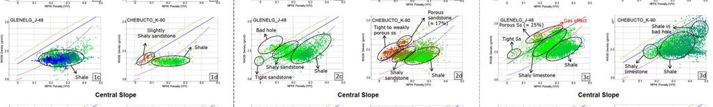
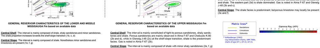
20 GDE MAPPING Main reservoir characteristics Main trap styles Petrophysical parameters used as an input for the GDE mapping originate from the PFA (2011) and data compiled by CNSOPB (Kidson et al., 2002; Kidson et al., 2007). The wells used are considered to be representative of the study area: Central Shelf: Alma F67, Cohasset L97, Glenelg J48, Chebucto K90 Central slope: Annapolis G24, Crimson F81, Tantallon M41 Reservoir facies and characteristics were obtained from: The integration of sequence stratigraphy and lithostratigraphic breakdown from the 10 key wells. Logs signature and interpreted lithological columns. Vertical facies distribution from the wells for each main sequence in reservoir and non reservoir units (Gross reservoir and Gross shale results). Cross plots based on Neutron Density and GR and tied to the standard regression lines of basic lithologies: anhydrite, dolomite, limestone, sandstone. Porosity results from previous reservoir studies (Kidson et al., 2002; Kidson et al., 2007; OETR, 2011). Reservoir characteristics from key wells for the main play intervals: Baccaro Mbr: up to 1200m thick, predominantly limestone with minor shale intervals. Weak porosity in carbonates, nonetheless reaching % when oolithic or dolomitic facies are present. Mic Mac Formation: thick Late Jurassic delta complex. Good reservoir quality with 15-18% porosity on in average. The shale content is mainly attributed to the Misaine Member. Lower Missisauga (Tithonian - Berriasian): lower unit mostly sandy, some limestone intervals; upper unit shaly; average porosity of 15%. Middle Missisauga (Berriasian - Hauterivian): Thick section of sandstone with average porosity of 15%. Upper Missisauga (Hauterivian - Barremian): Predominantly sandy sequence, some shales and limestone intervals. Average porosity of 18%, limestones are tight. Logan Canyon Formation (Aptian Cenomanian): sandy sequence, some shale and limestone intervals. Reservoir types: estuarine, swallow marine clastic, turbidites sandstones. Average porosity of 23%. Limestones are tight. Lithology Depositional Environment Porosity Range (%) Average Porosity (%) Mic-Mac/Baccaro Mixed clastic-carbonate facies. Interbedded sandstone, siltstone and shale; limestone facies. Delta front; carbonate platform and reef margin 3 to 24 15% in clastic sand Lower Missisauga Fine to coarse sand and sandy shale; poorly to well sorted. Calcitic and siliceous sedimentation. Calcareous shale and oolitic limestone Deltaic fluvial channels and strandplain-shoreface 8 to Middle Missisauga Fine to coarse sand and sandy shale, sometimes intraclast conglomerate; poorly to well sorted; carbonate corresponds to oolitic limestone. Deltaïc fluvial channels and strandplain-shoreface 12 to Upper Missisauga Very fine to coarse grained sand (occasionally pebbly). Moderate to well sorted sediment. Calcitic and siliceous sedimentation. Presence of authigenic grain-coating chlorite. Interbedded shale and silt. Carbonate corresponds to skeletal and oolitic wackestone to packstone, tight limestone and marl Deltaïc fluvial channels and strandplain-shoreface; 11.4 to References Kidson, A. G., Brenton, M.S., Brown, D. E., C., and Altheim, B., Hydrocarbon Potential of the Deep Water Scotian Slope. CNSOPB Report, 111p, Halifax, Nova Scotia. Kidson, A. G., Brenton, M.S., Brown, D. E., Makrides, C., and Altheim, B., Nova Scotia Deepwater Wells, Post Drill Analysis, p CNSOPB Report,181p, Halifax, Nova Scotia. Logan Canyon Very fine to fine sandstone with noticeable quantities of carbonaceous material and kaolinite. Sediment poorly to very well sorted. Sandstone interbedded with shale. Delta front and strandplainshoreface; lagoonal shale. 12 to Offshore Energy Technical Research Association (OETR), Play Fairway Analysis Atlas - Offshore Nova Scotia. Nova Scotia Department of Energy Report, NSDOE Records Storage File No , 347p. PL Methodology


21 GDE MAPPING Methodology PL


22 GDE MAPPING Gross Depositional Environment Map at J Stratigraphic Chart of the Scotian Margin Eastern Canada 3- Sediment source distribution along the Scotian and South Newfoundland Margins during the late Triassic 4- J200 Structure Map 5- J200 Interval in Annapolis Cross-section 5 PL J200 GDE Map
23 GDE MAPPING Gross Depositional Environment Map for the Scatarie Mbr interval 2-Stratigraphic Chart of the Scotian Margin Eastern Canada 4 3- Sediment source distribution along the Scotian and South Newfoundland Margins during the early Jurassic 4- J 163 J200 Thickness Map 5- J163 J200 Interval in Annapolis Cross-section 5 SCATARIE Mbr GDE Map PL

24 GDE MAPPING Gross Depositional Environment Map at J Stratigraphic Chart of the Scotian Margin Eastern Canada 3- Sediment source distribution along the Scotian and South Newfoundland Margins during the early Jurassic 4- J163 Structure Map 5- J163 J200 Interval in Annapolis Cross-section 5 PL J163 GDE Map

25 SEISMIC STRATIGRAPHY Gross Depositional Environment Map for the Abenaki/MicMac interval 2-Stratigraphic Chart of the Scotian Margin Eastern Canada 4 3- Sediment source distribution along the Scotian and South Newfoundland Margins during the Middle Jurassic 4- J 150 J150 Thickness Map 5- J150 - J163 Interval in Annapolis Cross-section 5 ABENAKI Fm/MicMac Fm GDE Map PL
26 GDE MAPPING Gross Depositional Environment Map at J Stratigraphic Chart of the Scotian Margin Eastern Canada 3- Sediment source distribution along the Scotian and South Newfoundland Margins during the Middle Jurassic 4- J150 Structure Map 5- J150 - J163 Interval in Annapolis Cross-section 5 PL J150 GDE Map

27 SEISMIC STRATIGRAPHY Gross Depositional Environment Map for the Lower Missisauga interval 2-Stratigraphic Chart of the Scotian Margin Eastern Canada 4 3- Sediment source distribution along the Scotian and South Newfoundland Margin during the Late Jurassic Early Cretaceous 4- K 137 J150 Thickness Map 5- K137 - J150 Interval in Annapolis Cross-section 5 Lower MISSISSAUGA Fm GDE Map PL
28 GDE MAPPING Gross Depositional Environment Map at K Stratigraphic Chart of the Scotian Margin Eastern Canada 3- Sediment source distribution along the Scotian and South Newfoundland Margin during the Late Jurassic Early Cretaceous 4- K 137 Structure Map 5- K137 - J150 Interval in Annapolis Cross-section 5 PL K137 GDE Map
29 SEISMIC STRATIGRAPHY Gross Depositional Environment Map for the Middle Missisauga interval 2-Stratigraphic Chart of the Scotian Margin Eastern Canada 4 3- Sediment source distribution along the Scotian and South Newfoundland Margins during the Early Cretaceous 4- K 130 K137 Thickness Map 5- K130 - K137 Interval in Annapolis Cross-section 5 Middle MISSISAUGA Fm GDE map PL


30 GDE MAPPING Gross Depositional Environment Map at K Stratigraphic Chart of the Scotian Margin Eastern Canada 3- Sediment source distribution along the Scotian and South Newfoundland Margins during the Early Cretaceous 4- K 130 Structure Map 5- K130 - K137 Interval in Annapolis Cross-section 5 PL K130 GDE Map


31 SEISMIC STRATIGRAPHY Gross Depositional Environment Map for the Logan Canyon interval 2-Stratigraphic Chart of the Scotian Margin Eastern Canada 4 3- Sediment source distribution along the Scotian and South Newfoundland Margins during Aptian (left) and Albian (right) 4- K 101 K130 Thickness Map 5- K101 - K130 Interval in Annapolis Cross-section 5 LOGAN CANYON Fm GDE map PL
32 GDE MAPPING Gross Depositional Environment Map at K Stratigraphic Chart of the Scotian Margin Eastern Canada 3- Sediment source distribution along the Scotian and South Newfoundland Margins during the Late Cretaceous 4- K 101 Structure Map 5- K101 - K130 Interval in Annapolis Cross-section 5 PL K101 GDE Map


33 SEISMIC STRATIGRAPHY Gross Depositional Environment Map at K Stratigraphic Chart of the Scotian Margin Eastern Canada 3- Sediment source distribution along the Scotian and South Newfoundland Margin during the Late Cretaceous 4- K 94 Structure Map 5- K94 - K101 Interval in Annapolis Cross-section 5 K94 GDE Map PL
34
Application of Predictive Modeling to the Lower Cretaceous Sedimentary Sequences of the Central Scotian Basin
 Application of Predictive Modeling to the Lower Cretaceous Sedimentary Sequences of the Central Scotian Basin Christopher R. Sangster 1, Nicolas Hawie 2, Georgia Pe-Piper 1, Francky Saint-Ange 2, David
CHAPTER 4 SEISMIC INTERPRETATION
 CHAPTER 4 SEISMIC INTERPRETATION CHAPTER 4.1 DATABASE FOR SEISMIC INTERPRETATION SEISMIC INTERPRETATION - WELL TO SEISMIC CALIBRATION Central Scotian Slope Study CANADA July 2016 Seismic database The
Play Fairway Evaluation of the Eastern Nova Scotia Passive Margin New Data, New Insights*
 Play Fairway Evaluation of the Eastern Nova Scotia Passive Margin New Data, New Insights* Adam MacDonald 1 and Matt Luheshi 2 Search and Discovery Article #10646 (2014) Posted October 6, 2014 *Adapted
Acid Gas Injection at Deep Panuke
 Acid Gas Injection at Deep Panuke Terrance Skrypnek, Group Lead, Deep Panuke Sub-Surface Nova Scotia Energy and Research Development Forum St. Francis Xavier University, Antigonish, Nova Scotia May 21
REGIONAL GEOLOGY OF THE SCOTIAN BASIN
 REGIONAL GEOLOGY OF THE SCOTIAN BASIN David E. Brown, CNSOPB, 2008 INTRODUCTION The Scotian Basin is a classic passive, mostly non-volcanic, conjugate margin. It represents over 250 million years of continuous
OETR ova Scotia Pay Fairway Analysis - summary. Matt Luheshi Halifax 21 st January 2014
 OETR 2009-2011 ova Scotia Pay Fairway Analysis - summary Matt Luheshi Halifax 21 st January 2014 2007 Gap Analysis Technical Issues Nova Scotia Geoscience Gap Analysis Issues How good is the source rock
Meandering Miocene Deep Sea Channel Systems Offshore Congo, West Africa
 Meandering Miocene Deep Sea Channel Systems Offshore Congo, West Africa S. Baer* (PGS), J. E. Comstock (PGS), K. Vrålstad (PGS), R. Borsato (PGS), M. Martin (PGS), J.P. Saba (SNPC), B. Débi-Obambé (SNPC)
Scotian Basin Petroleum and Source Rocks (an explorationist s perspective)
") Scotian Basin Petroleum and Source Rocks (an explorationist s perspective) David E. Brown Senior Advisor, Geology Canada-Nova Scotia Offshore Petroleum Board 21 January 2014 1 PREVIOUS RESEARCH Since early
Scotian Basin Petroleum and Source Rocks (an explorationist s perspective) David E. Brown Senior Advisor, Geology Canada-Nova Scotia Offshore Petroleum Board 21 January 2014 1 PREVIOUS RESEARCH Since early
Controls on clastic systems in the Angoche basin, Mozambique: tectonics, contourites and petroleum systems
 P2-2-13 Controls on clastic systems in the Angoche basin, Mozambique: tectonics, contourites and petroleum systems Eva Hollebeek, Olivia Osicki, Duplo Kornpihl Schlumberger, London, UK Introduction Offshore
A comparison of structural styles and prospectivity along the Atlantic margin from Senegal to Benin. Peter Conn*, Ian Deighton* & Dario Chisari*
 A comparison of structural styles and prospectivity along the Atlantic margin from Senegal to Benin Overview Peter Conn*, Ian Deighton* & Dario Chisari* * TGS, Millbank House, Surbiton, UK, KT6 6AP The
EGAS. Ministry of Petroleum
 EGAS Ministry of Petroleum EGAS Ministry of Petroleum About The Block Location: N. Thekah offshore block is located at about 56 km to the north of the Mediterranean shore line, 85 km to the north west
Aptian/Albian Reservoir Development in the Jeanne d Arc Basin, Offshore Eastern Canada
 Aptian/Albian Reservoir Development in the Jeanne d Arc Basin, Offshore Eastern Canada Jonathan Marshall, Statoil Canada Ltd. Calgary, Alberta, Canada. jomars@statoil.com Introduction: The Jeanne d Arc
EGAS. Ministry of Petroleum
 EGAS Ministry of Petroleum EGAS Ministry of Petroleum About The Block Location: N. El Arish offshore block is located in the extreme eastern part of the Egypt s economic water border and bounded from the
Sequence Stratigraphy. Historical Perspective
 Sequence Stratigraphy Historical Perspective Sequence Stratigraphy Sequence Stratigraphy is the subdivision of sedimentary basin fills into genetic packages bounded by unconformities and their correlative
Call for Bids NS18-3 Seismic Interpretation, well summaries, source rock, and exploration leads in the Central Scotian Shelf, Sable Subbasin.
 Call for Bids NS18-3 Seismic Interpretation, well summaries, source rock, and exploration leads in the Central Scotian Shelf, Sable Subbasin. Brenton M. Smith*, Kris Kendell, David Brown, Carl Makrides,
A Tectonostratigraphic History of Orphan Basin, Offshore Newfoundland, Canada
 A Tectonostratigraphic History of Orphan Basin, Offshore Newfoundland, Canada Lynn T. Dafoe*, Charlotte E. Keen, Graham L. Williams, and Sonya A. Dehler, Geological Survey of Canada, Dartmouth, NS Canada
MUHAMMAD S TAMANNAI, DOUGLAS WINSTONE, IAN DEIGHTON & PETER CONN, TGS Nopec Geological Products and Services, London, United Kingdom
 Geological and Geophysical Evaluation of Offshore Morondava Frontier Basin based on Satellite Gravity, Well and regional 2D Seismic Data Interpretation MUHAMMAD S TAMANNAI, DOUGLAS WINSTONE, IAN DEIGHTON
PLATEAU UPLIFT, EPEIROGENEY AND CLIMATE CHANGES The KALAHARI PLATEAU, a world class laboratory
 PLATEAU UPLIFT, EPEIROGENEY AND CLIMATE CHANGES The KALAHARI PLATEAU, a world class laboratory F. Guillocheau M. De Wit G. Dubois B. Linol F. Eckardt W. Cotterill D. Rouby C. Robin Géosciences-Rennes Université
Orphan Basin, Offshore Newfoundland: New seismic data and hydrocarbon plays for a dormant Frontier Basin
 Orphan Basin, Offshore Newfoundland: New seismic data and hydrocarbon plays for a dormant Frontier Basin Jerry Smee* G&G Exploration Consulting, 301 400-3rd Avenue SW, Calgary, AB, T2P 4H2 Sam Nader, Paul
Bulletin of Earth Sciences of Thailand
 Quantitative Seismic Geomorphology of Early Miocene to Pleistocene Fluvial System of Northern Songkhla Basin, Gulf of Thailand Oanh Thi Tran Petroleum Geoscience Program, Department of Geology, Faculty
Bulletin of Earth Sciences of Thailand. Evaluation of the Petroleum Systems in the Lanta-Similan Area, Northern Pattani Basin, Gulf of Thailand
 Evaluation of the Petroleum Systems in the Lanta-Similan Area, Northern Pattani Basin, Gulf of Thailand Sirajum Munira Petroleum Geoscience Program, Department of Geology, Faculty of Science, Chulalongkorn
Mid Cretaceous sand supply to offshore SW Nova Scotia: tectonic diversion of Labrador rivers during Naskapi Member deposition
 1 Mid Cretaceous sand supply to offshore SW Nova Scotia: tectonic diversion of Labrador rivers during Naskapi Member deposition Final Report OERA Research Project number 400-170 Total project duration:
Introduction to sequence stratigraphy and its application to reservoir geology
 Introduction to sequence stratigraphy and its application to reservoir geology Massimo Zecchin Istituto Nazionale di Oceanografia e di Geofisica Sperimentale - OGS Historical development Definitions Systems
Fluvial-Estuarine and Deltaic Reservoirs, Shelf Margin Delta and Slope Reservoir Characteristics Philip Sedore 2015
 Fluvial-Estuarine and Deltaic Reservoirs, Shelf Margin Delta and Slope Reservoir Characteristics Philip Sedore 2015 Introduction The offshore Columbus Basin and the onshore Southern Basin of Trinidad are
Deepwater Hydrocarbon Potentialof Orange Basin, South Africa: An Untested Oil Play
 Deepwater Hydrocarbon Potentialof Orange Basin, South Africa: An Untested Oil Play Soumen Dasgupta*, Moumita Sengupta, Prem Kumar, Biswanath Ghosh, Dr. BNS Naidu anddr. Sudhir Mathur. Cairn India Limited,
Ministry of Oil and Minerals Petroleum Exploration & Production Authority BLOCK 85 (Al Uqlah North)
") Ministry of Oil and Minerals Petroleum Exploration & Production Authority BLOCK 85 (Al Uqlah North) The Al Uqlah North Block (85) occupies an area of 597 km 2 in the Sabatayn Basin in the province of Shabwah
Ministry of Oil and Minerals Petroleum Exploration & Production Authority BLOCK 85 (Al Uqlah North) The Al Uqlah North Block (85) occupies an area of 597 km 2 in the Sabatayn Basin in the province of Shabwah
Ministry of Oil and Minerals Petroleum Exploration & Production Authority BLOCK 6 (Iryam)
") Ministry of Oil and Minerals Petroleum Exploration & Production Authority BLOCK 6 (Iryam) The Iryam Block (6) occupies an area of 3,911 km 2 in the Sabatayn Basin in the province of Shabwah in central
Ministry of Oil and Minerals Petroleum Exploration & Production Authority BLOCK 6 (Iryam) The Iryam Block (6) occupies an area of 3,911 km 2 in the Sabatayn Basin in the province of Shabwah in central
Supplementary Material for Eighty million years of folding migration: new perspective on the Syrian Arc from Levant basin analysis
 GSA Data Repository 2018040 https://doi.org/10.1130/g39654.1 Supplementary Material for Eighty million years of folding migration: new perspective on the Syrian Arc from Levant basin analysis Sagy Yael,
Case Study of the Structural and Depositional-Evolution Interpretation from Seismic Data*
 Case Study of the Structural and Depositional-Evolution Interpretation from Seismic Data* Yun Ling 1, Xiangyu Guo 1, Jixiang Lin 1, and Desheng Sun 1 Search and Discovery Article #20143 (2012) Posted April
Thesis Proposal: Salt Reconstruction and Study of Depositional History, Upper Jurassic, East Texas Basin
 Thesis Proposal: Salt Reconstruction and Study of Depositional History, Upper Jurassic, East Texas Basin By: Krista Mondelli Advisor: Dr. Chris Liner April, 2009 2 Introduction The East Texas Basin covers
Play fairway mapping in the Northeast Atlantic Margin Comparison between mature and immature basins. David Mudge, Joanne Cranswick
 Play fairway mapping in the Northeast Atlantic Margin Comparison between mature and immature basins David Mudge, Joanne Cranswick Contents Ternan North Sea Play fairway mapping Tertiary case study Northeast
Effects of Tides on Deltaic Deposition: Causes and Responses*
 Effects of Tides on Deltaic Deposition: Causes and Responses* Piret Plink-Bjorklund 1 Search and Discovery Article #50626 (2012)** Posted June 25, 2012 *Adapted from oral presentation at AAPG Annual Convention
Accommodation. Tectonics (local to regional) Subsidence Uplift
 Subsidence Uplift") Accommodation Accommodation varies over time; it is the distance between a reference horizon and the sea surface (i.e. relative sea level). The space to be filled in with sediments or water What are the
Accommodation Accommodation varies over time; it is the distance between a reference horizon and the sea surface (i.e. relative sea level). The space to be filled in with sediments or water What are the
Regional Paleogeography and Implications for Petroleum Prospectivity, Taranaki Basin, New Zealand*
 Regional Paleogeography and Implications for Petroleum Prospectivity, Taranaki Basin, New Zealand* Dominic P. Strogen 1, Kyle J. Bland 1, Jan R. Baur 1,2, and Peter R. King 1 Search and Discovery Article
Perspectives from Offshore Argentina & Uruguay
 Perspectives from Offshore Argentina & Uruguay A Prospectivity Overview Hannah Kearns October 2018 Introduction Argentina Offshore License Round 1 14 blocks Argentina North, 24 Austral-Malvinas Offshore
Southern Songkhla Basin, Gulf of Thailand
 Architecture and Depositional Environment of Fluvial Systems of Southern Songkhla Basin, Gulf of Thailand Toan Manh Do Petroleum Geoscience Program, Department of Geology, Faculty of Science, Chulalongkorn
The impact of volcanism on reservoir quality, Scotian Basin
 The impact of volcanism on reservoir quality, Scotian Basin Georgia Pe-Piper*, Department of Geology, Saint Mary s University, Halifax, Nova Scotia, B3H 3C3, Canada gpiper@smu.ca and David J.W. Piper*,
Block 43B - Onshore Oman
 Block 43B - Onshore Oman SUMMARY Block 43B is an 11,967 km 2 area located along the coastal area of Oman north of the Hajar Mountains. This is an unexplored region, both geographically and stratigraphically.
APPENDIX C GEOLOGICAL CHANCE OF SUCCESS RYDER SCOTT COMPANY PETROLEUM CONSULTANTS
 APPENDIX C GEOLOGICAL CHANCE OF SUCCESS Page 2 The Geological Chance of Success is intended to evaluate the probability that a functioning petroleum system is in place for each prospective reservoir. The
Sequence stratigraphy and basin analysis of the Meso- to Cenozoic Tarfaya- Laayoune Basins, on- and offshore Morocco
 Sequence stratigraphy and basin analysis of the Meso- to Cenozoic Tarfaya- Laayoune Basins, on- and offshore Morocco INAUGURAL-DISSERTATION zur Erlangung der Doktorwtirde der Naturwissenschaftlich-Mathematischen
Vail et al., 1977b. AAPG 1977 reprinted with permission of the AAPG whose permission is required for further use.
 Well 5 Well 4 Well 3 Well 2 Well 1 Vail et al., 1977b AAPG 1977 reprinted with permission of the AAPG whose permission is required for further use. Well 5 Well 4 Well 3 Well 2 Well 1 Vail et al., 1977b
Dalhousie University- Petroleum Geoscience Field Methods- Trinidad Summary Report
 Dalhousie University- Petroleum Geoscience Field Methods- Trinidad Summary Report Submitted to: Offshore Energy Research Association of Nova Scotia (OERA) To fulfill requirements of the Undergraduate Student
Depositional Sequences Sequences
 Depositional Sequences Transgressive and Regressive packages can be bound by unconformities Because sediment can only be preserved during net aggradation and progradation All other times there is either
Abstract. Introduction. Regional Setting. GCSSEPM to be published December 2003
 Shelf Margin Deltas and Associated Deepwater Deposits: Implications on Reservoir Distribution and Hydrocarbon Entrapment, Block VI-1, Ulleung Basin, East Sea, South Korea Sneider, John S. Sneider Exploration,
Hydrocarbon Exploration of Mesozoic in Kutch Offshore Area
 6 th International Conference & Exposition on Petroleum Geophysics Kolkata 2006 Hydrocarbon Exploration of Mesozoic in Kutch Offshore Area Ram Krishna Singh 1, R.C. Agrawalla 2, D. P. Verma 3, A. K. Goel
Play Fairway Analysis and Petroleum System Modeling. Bernard Colletta Exploration Project Director
 Play Fairway Analysis and Petroleum System Modeling Bernard Colletta Exploration Project Director Objectives Promote further exploration of the Nova Scotia margin Better understanding of the geology of
Depositional History and Petroleum Potential of Ombilin Basin, West Sumatra - Indonesia, Based on Surface Geological Data*
 Depositional History and Petroleum Potential of Ombilin Basin, West Sumatra - Indonesia, Based on Surface Geological Data* Yahdi Zaim 1, Litto Habrianta 2, Chalid I. Abdullah 1, Aswan 1, Yan Rizal 1, Nurcahyo
Sedimentary Cycle Best Practice: Potential Eo-Oligocene Sediments in Western Indonesia*
 Sedimentary Cycle Best Practice: Potential Eo-Oligocene Sediments in Western Indonesia* Mellinda Arisandy 1 and I Wayan Darma 1 Search and Discovery Article #11008 (2017)** Posted November 6, 2017 *Adapted
Seismic stratigraphy, some examples from Indian Ocean, interpretation of reflection data in interactive mode
 Seismic stratigraphy, some examples from Indian Ocean, interpretation of reflection data in interactive mode K. S. Krishna National Institute of Oceanography, Dona Paula, Goa-403 004. krishna@nio.org Seismic
Search and Discovery Article #20222 (2013)** Posted November 25, 2013
** Posted November 25, 2013") 3D Static and Dynamic Modeling of a Clastic Multilayered Reservoir with Heavy Oil: a Case Study from Comodoro Rivadavia Formation in El Alba Valle Field (Manantiales Behr Block, Golfo San Jorge Basin,
3D Static and Dynamic Modeling of a Clastic Multilayered Reservoir with Heavy Oil: a Case Study from Comodoro Rivadavia Formation in El Alba Valle Field (Manantiales Behr Block, Golfo San Jorge Basin,
Salt Geology and New Plays in Deep-Water Gulf of Mexico* By Abu Chowdhury 1 and Laura Borton 1
 Salt Geology and New Plays in Deep-Water Gulf of Mexico* By Abu Chowdhury 1 and Laura Borton 1 Search and Discovery Article #10131 (2007) Posted August 25, 2007 *Adapted from extended abstract prepared
Tectonics and Hydrocarbon System, East Gobi Basin, Mongolia. Gary Prost, ConocoPhillips Canada, Calgary
 Tectonics and Hydrocarbon System, East Gobi Basin, Mongolia Gary Prost, ConocoPhillips Canada, Calgary Project Objectives (a joint project of Gulf Canada and ROC Oil) What structures can be expected in
Carboniferous Stoddart Group: An integrated approach
 Carboniferous Stoddart Group: An integrated approach Abu Yousuf*, Department of Geoscience, University of Calgary, Calgary, Alberta yousufabu@hotmail.com and Charles M. Henderson, Department of Geoscience,
F.H. NADER 1, PETROLEUM SYSTEMS MODELING CHALLENGES OF STRUCTURALLY COMPLEX FRONTIER BASINS: THE CASE OF THE LEVANT (EAST-MED) BASIN
 BASIN") PETROLEUM SYSTEMS MODELING CHALLENGES OF STRUCTURALLY COMPLEX FRONTIER BASINS: THE CASE OF THE LEVANT (EAST-MED) BASIN A PROPOSED INTEGRATED APPROACH F.H. NADER 1, J. Barabasch 2, L. Inati 1, M. Ducros
PETROLEUM SYSTEMS MODELING CHALLENGES OF STRUCTURALLY COMPLEX FRONTIER BASINS: THE CASE OF THE LEVANT (EAST-MED) BASIN A PROPOSED INTEGRATED APPROACH F.H. NADER 1, J. Barabasch 2, L. Inati 1, M. Ducros
Structural Geology of the Mountains
 Structural Geology of the Mountains Clinton R. Tippett Shell Canada Limited, Calgary, Alberta clinton.tippett@shell.ca INTRODUCTION The Southern Rocky Mountains of Canada (Figure 1) are made up of several
OUTCROP! CHARACTERISATION! OF! TRANSGRESSIVE! SANDSTONE! RESERVOIRS:! QUANTITATIVE!COMPARISON!OF!OUTCROP!ANALOGUES!
 OUTCROP CHARACTERISATION OF TRANSGRESSIVE SANDSTONE RESERVOIRS: QUANTITATIVECOMPARISONOFOUTCROPANALOGUES OLIVER D. JORDAN 1, PETER J. SIXSMITH 2, GARY J. HAMPSON, SANJEEV GUPTA & HOWARDD.JOHNSON DepartmentofEarthScienceandEngineering,ImperialCollegeLondon,SouthKensington
The Late Tertiary Deep-Water Siliciclastic System of the Levant Margin - An Emerging Play Offshore Israel*
 The Late Tertiary Deep-Water Siliciclastic System of the Levant Margin - An Emerging Play Offshore Israel* Michael A. Gardosh 1, Yehezkel Druckman 2 and Binyamin Buchbinder 2 Search and Discovery Article
Figure 1 Extensional and Transform Fault Interaction, Influence on the Upper Cretaceous Hydrocarbon System, Equatorial Margin, West Africa.
 Figure 1 Extensional and Transform Fault Interaction, Influence on the Upper Cretaceous Hydrocarbon System, Equatorial Margin, West Africa. Presented to the 10th PESGB/HGS Conference on Africa E + P September
eni s.p.a. upstream & technical services
 eni s.p.a. upstream & technical services 2013-2014 Master in Petroleum Engineering and Operations Congo & Angola Offshore-Congo River Basin Characteristics, exploitation approach and fields analogues Author:
Petroleum geology framework, West Coast offshore region
 Petroleum geology framework, West Coast offshore region James W. Haggart* Geological Survey of Canada, Vancouver, BC jhaggart@nrcan.gc.ca James R. Dietrich Geological Survey of Canada, Calgary, AB and
Figure 1: Location and bathymetry of the study area. Gulf of Guinea. Cameroon. Congo. Gabon. PGS/DGH Gabon MegaSurvey Coverage (35000Km 2 ) Eq.
 Eq.") Deepwater hydrocarbon prospectivity analysis of offshore North and South Gabon Muhammad S Tamannai (*), Thomas Hansen (1), Ron Borsato (1), Jennifer Greenhalgh (1) Martial-Rufin Moussavou (2) & Landry
Deepwater hydrocarbon prospectivity analysis of offshore North and South Gabon Muhammad S Tamannai (*), Thomas Hansen (1), Ron Borsato (1), Jennifer Greenhalgh (1) Martial-Rufin Moussavou (2) & Landry
The Sierra Leone-Liberia Emerging Deepwater Province*
 The Sierra Leone-Liberia Emerging Deepwater Province* Joan F. Flinch 1, José L. Huedo 1, Hernán Verzi 1, Héctor González 1, Ricardo Gerster 1, Abdul K. Mansaray 1, L. P. Painuly 1, Leticia Rodriguez-Blanco
Petroleum Prospectivity in the Namibe and Southern Benguela Basins, Offshore Angola
 Petroleum Prospectivity in the Namibe and Southern Benguela Basins, Offshore Angola C. Koch* (PGS), F. Pepe (PGS), R. Vasconcelos (PGS), F. Mathew (PGS), R. Borsato (PGS) & M.P.C. de Sá (Sonangol) SUMMARY
Bulletin of Earth Sciences of Thailand. Controls on Reservoir Geometry and Distribution, Tantawan Field, Gulf of Thailand.
 Controls on Reservoir Geometry and Distribution, Tantawan Field, Gulf of Thailand Atchara Praidee Petroleum Geoscience Program, Department of Geology, Faculty of Science, Chulalongkorn University, Bangkok
SEDIMENTARY BASINS BASIN TYPES ACCORDING TO TECTONIC. by Prof. Dr. Abbas Mansour
 SEDIMENTARY BASINS BASIN TYPES ACCORDING TO TECTONIC by Prof. Dr. Abbas Mansour B. Convergent plate margins 10. STABLE CONTINENTAL INTERIOR BASIN E.g. Lake Eyre Basin Intracratonic (= within stable continental
Salt tectonic styles in the spreading basin: Yucatan, Offshore Mexico Purnima Bhowmik*, Rodolfo Hernandez and Katarina Rothe, TGS
 1 Purnima Bhowmik*, Rodolfo Hernandez and Katarina Rothe, TGS Summary The TGS Gigante project is comprised of 188,497 km of 2D seismic data acquired in 2016 and primarily covering the offshore Mexican
P. S. Basak, Ravi Kant, K. Yasodha, T. Mukherjee, P. Rajanarayana, Sucheta Dotiwala, V. K. Baid, P.H. Rao, V. Vairavan, ONGC
 P-483 Summary Delineation of pinch-outs within Panna Formation of Paleocene-Early Eocene sequence in and around South Mumbai Low to Identify Prospective Areas - A Case Study P. S. Basak, Ravi Kant, K.
Integrated well log and 3-D seismic data interpretation for the Kakinada area of KG PG offshore basin
 IOSR Journal of Applied Geology and Geophysics (IOSR-JAGG) e-issn: 2321 0990, p-issn: 2321 0982.Volume 5, Issue 4 Ver. II (Jul. Aug. 2017), PP 01-05 www.iosrjournals.org Integrated well log and 3-D seismic
Search and Discovery Article #40536 (2010) Posted June 21, 2010
 Posted June 21, 2010") Modern Examples of Mass Transport Complexes, Debrite and Turbidite Associations: Geometry, Stratigraphic Relationships and Implications for Hydrocarbon Trap Development* Fabiano Gamberi 1, Marzia Rovere
Modern Examples of Mass Transport Complexes, Debrite and Turbidite Associations: Geometry, Stratigraphic Relationships and Implications for Hydrocarbon Trap Development* Fabiano Gamberi 1, Marzia Rovere
Request For Bids Parcels
 Section 2 Page 14 This section provides a detailed description of each landsale parcel. Maps provided show the location of the land parcels and the released seismic data on those parcels. Hard copies and
Fluid-Mud Deposits of the Lower Jurassic Tilje Formation, Offshore Mid-Norway By Aitor A. Ichaso and Robert W. Dalrymple 1
 Fluid-Mud Deposits of the Lower Jurassic Tilje Formation, Offshore Mid-Norway By Aitor A. Ichaso and Robert W. Dalrymple 1 Search and Discovery Article #50107 (2008) Posted August 10, 2008 *Adapted from
BALOCHISTAN FOLDBELT BASIN
 INTRODUCTION BALOCHISTAN FOLDBELT BASIN The Kharan-3 block is located in the Kharan Trough of Balochistan Basin. GEOLOGICAL SETTING The Balochistan Province is an Upper Cretaceous to Recent structurally
Kilometre-Scale Uplift of the Early Cretaceous Rift Section, Camamu Basin, Offshore North-East Brazil*
 Kilometre-Scale Uplift of the Early Cretaceous Rift Section, Camamu Basin, Offshore North-East Brazil* Iain Scotchman 1 and Dario Chiossi 2 Search and Discovery Article #50183 (2009) Posted May 20, 2009
Quantitative Tarfaya Basin Development, Morocco*
 Quantitative Tarfaya Basin Development, Morocco* Axel Wenke 1, Rainer Zühlke 1, Haddou Jabour 2, Oliver Kluth 3, and Torge Schümann 3 Search and Discovery Article #10420 (2012)** Posted July 16, 2012 *Adapted
High-resolution Sequence Stratigraphy of the Glauconitic Sandstone, Upper Mannville C Pool, Cessford Field: a Record of Evolving Accommodation
 Page No. 069-1 High-resolution Sequence Stratigraphy of the Glauconitic Sandstone, Upper Mannville C Pool, Cessford Field: a Record of Evolving Accommodation Thérèse Lynch* and John Hopkins, Department
Structural Styles and Geotectonic Elements in Northwestern Mississippi: Interpreted from Gravity, Magnetic, and Proprietary 2D Seismic Data
 Structural Styles and Geotectonic Elements in Northwestern Mississippi: Interpreted from Gravity, Magnetic, and Proprietary 2D Seismic Data Nick Loundagin 1 and Gary L. Kinsland 2 1 6573 W. Euclid Pl.,
Relinquishment Report. for. Licence P1605, Block 220/27
 Relinquishment Report for Licence P1605, Block 220/27 November 2013 Licence P.1605 Relinquishment Report August 2012 1 of 11 CONTENT 1 Introduction 2 - Exploration Summary 2.1 Exploration Activity 2.2
DATA ANALYSIS AND INTERPRETATION
 III. DATA ANALYSIS AND INTERPRETATION 3.1. Rift Geometry Identification Based on recent analysis of modern and ancient rifts, many previous workers concluded that the basic structural unit of continental
Figure 1. Examples of vector displacement diagrams for two and three-plate systems.
 Figure 1. Examples of vector displacement diagrams for two and three-plate systems. Figure 2. Relationships between pole of rotation, great circles, ridge segments, small circles, transforms and fracture
Biostratigraphic and Lithostratigraphic Correlation of Sedimentary Strata in the Atlantic Coastal Plain
 Biostratigraphic and Lithostratigraphic Correlation of Sedimentary Strata in the Atlantic Coastal Plain Introduction to the Atlantic Coastal Plain (Please read this page prior to doing the lab) The Atlantic
Future giant discovery in the Outeniqua Basin, offshore South Africa. Anongporn Intawong & Neil Hodgson
 Future giant discovery in the Outeniqua Basin, offshore South Africa Anongporn Intawong & Neil Hodgson Spectrum Geoscience 23 February 2017 1 Talk Outlines Structural framework & Evolution of the South
Deepwater Niger Delta fold-and-thrust belt modeled as a critical-taper wedge: The influence of a weak detachment on styles of fault-related folds
 Deepwater Niger Delta fold-and-thrust belt modeled as a critical-taper wedge: The influence of a weak detachment on styles of fault-related folds Frank Bilotti 1, Chris Guzofski 1, John H. Shaw 2 1 Chevron
Geologic influence on variations in oil and gas production from the Cardium Formation, Ferrier Oilfield, west-central Alberta, Canada
 Geologic influence on variations in oil and gas production from the Cardium Formation, Ferrier Oilfield, west-central Alberta, Canada Marco Venieri and Per Kent Pedersen Department of Geoscience, University
ANGOLA OFFSHORE LICENSING 2007 BLOCK 46
 AGOLA OFFHOR LICIG 2007 BLOCK 46 DATA BA AVAILABILITY Figure 1 shows the seismic data available on Block 46. Fig. 1 Commercial 2D surveys: esterngeco: 794 km. GX Technology: 116 km. Commercial 3D surveys:
35th Annual GCSSEPM Foundation Bob F Perkins Research Conference 2016
 35th Annual GCSSEPM Foundation Bob F Perkins Research Conference 2016 Mesozoic of the Gulf Rim and Beyond: New Progress in Science and Exploration of the Gulf of Mexico Basin Houston, Texas, USA 8 9 December
Structural Style and Tectonic Evolution of the Nakhon Basin, Gulf of Thailand
 Structural Style and Tectonic Evolution of the Nakhon Basin, Gulf of Thailand Piyaphong Chenrai Petroleum Geoscience Program, Department of Geology, Faculty of Science, Chulalongkorn University, Bangkok
Côte d I d Ivoire: Undiscovered Opportunities and voire: New Undiscovered Data in Open Opportunities Blocks and New Data in Open Blocks
 Côte d I d Ivoire: Undiscovered Opportunities and voire: New Undiscovered Data in Open Opportunities Blocks and New Data in Open Blocks Christine Roche, Project Geoscientist; PGS Christine Roche, Project
Maturity Modeling of Gomin and South Gomin fields Southern Pattani Basin, Gulf of Thailand
 Maturity Modeling of Gomin and South Gomin fields Southern Pattani Basin, Gulf of Thailand Patinya Jaithan Petroleum Geoscience Program, Department of Geology, Faculty of Science, Chulalongkorn University,
Distribution of Overpressure and its Prediction in Saurashtra Dahanu Block, Western Offshore Basin, India*
 Distribution of Overpressure and its Prediction in Saurashtra Dahanu Block, Western Offshore Basin, India* Kanak R. Nambiar 1, B.K. Singh 2, R.N. Goswami 2, and K.R.K. Singh 2 Search and Discovery Article
Paleogene low stand deepwater canyon fill deposits in Mahanadi Offshore Basin: can it prove to be the elusive major hydrocarbon discovery?
 P-317 Paleogene low stand deepwater canyon fill deposits in Mahanadi Offshore Basin: can it prove to be the elusive major Summary *Pradipta Kumar Das & Sudipto Datta, ONGC Mahanadi Deepwater Offshore Basin
Controls on facies distributions in the Charlie Lake Formation, Peace River Arch, Alberta
 Controls on facies distributions in the Charlie Lake Formation, Peace River Arch, Alberta E.L. Percy 12, C. Frostad 2, A. Juska 2, C. Schmidt 2, C. Sitzler 2, and J.P. Zonneveld 3 University of Calgary,
Drainage Systems in Rift Basins: Implications for Reservoir Quality*
 Drainage Systems in Rift Basins: Implications for Reservoir Quality* Stephen Schwarz 1 and Lesli Wood 2 Search and Discovery Article #30477 (2016)** Posted December 5, 2016 *Adapted from oral presentation
GeoConvention 2012: Vision 1
 Cretaceous possibilities: Sedimentology and reservoir potential of the Early Cretaceous Isachsen Formation of the Sverdrup Basin, Ellef Ringnes Island, Arctic Canada Dylan Tullius Department of Geoscience
ONSHORE / OFFSHORE & NEW SHALE POTENTIAL OF MOROCCO
 Kingdom of Morocco ONSHORE / OFFSHORE & NEW SHALE POTENTIAL OF MOROCCO Mr M. NAHIM Mrs N. ESSALLOUMI Key aspects of Morocco Political and economic stability; Economic policy of integration at regional
SAND DISTRIBUTION AND RESERVOIR CHARACTERISTICS NORTH JAMJUREE FIELD, PATTANI BASIN, GULF OF THAILAND
 SAND DISTRIBUTION AND RESERVOIR CHARACTERISTICS NORTH JAMJUREE FIELD, PATTANI BASIN, GULF OF THAILAND Benjawan KIinkaew Petroleum Geoscience Program, Department of Geology, Faculty of Science, Chulalongkorn
OFFSHORE OPPORTUNITY LICENCE ROUND
 OFFSHORE OPPORTUNITY - 2012 LICENCE ROUND CALL FOR BIDS NL12-02, FLEMISH PASS BASIN, OFFSHORE NEWFOUNDLAND EXECUTIVE SUMMARY On April 5th 2012, the Canada-Newfoundland and Labrador Offshore Petroleum Board
Arthur Saller 1. Search and Discovery Article #51393 (2017)** Posted June 26, Abstract
** Posted June 26, Abstract") PS Mixed Carbonates and Siliciclastics North of the Mahakam Delta, Offshore East Kalimantan, Indonesia* Arthur Saller 1 Search and Discovery Article #51393 (2017)** Posted June 26, 2017 *Adapted from poster
PS Mixed Carbonates and Siliciclastics North of the Mahakam Delta, Offshore East Kalimantan, Indonesia* Arthur Saller 1 Search and Discovery Article #51393 (2017)** Posted June 26, 2017 *Adapted from poster
entered a rapid development phase. Annual increased proven reserves are above 500 billion cubic meters (bcm) from 2003, and annual natural gas product
 from 2003, and annual natural gas product") (), entered a rapid development phase. Annual increased proven reserves are above 500 billion cubic meters (bcm) from 2003, and annual natural gas production has increased from 50bcm in 2000 to nearly
(), entered a rapid development phase. Annual increased proven reserves are above 500 billion cubic meters (bcm) from 2003, and annual natural gas production has increased from 50bcm in 2000 to nearly
Geological development of the Durban Basin
 Basin-scale assessment of the potential CO 2 storage of the offshore Durban Basin, KwaZulu-Natal, South Africa Geological development of the Durban Basin N. Hicks (MSc) (PhD Candidate) Senior Scientist
Facies Analysis Of The Reservoir Rocks In The. Sylhet Trough, Bangladesh. Abstract
 Facies Analysis Of The Reservoir Rocks In The Sylhet Trough, Bangladesh Joyanta Dutta Petroleum Geoscience Program, Department of Geology, Faculty of Science, Chulalongkorn University, Bangkok 10330, Thailand