Inversion Oxygenation and Bio augmentation Reduces Invasive Eurasian Watermilfoil Growth in Four Michigan Inland Lakes
|
|
|
- Rafe Franklin
- 5 years ago
- Views:
Transcription
1 Inversion Oxygenation and Bio augmentation Reduces Invasive Eurasian Watermilfoil Growth in Four Michigan Inland Lakes Jennifer L. Jermalowicz-Jones Restorative Lake Sciences Restorative Lake Sciences
2

3 Austin Lake, Kalamazoo County, MI Lake Volume = 4,408 acre-feet Mean Depth = 4.0 feet Max Depth = 14.0 feet Mean Annual Runoff = 330 acre-feet Mean Annual Pfizer Outputs = 350 acre-feet Mean Annual Inlet Inputs = 724 acre-feet Mean Annual Precip = 3,191 acre-feet Mean Evaporative Losses = 2,600 acre-feet

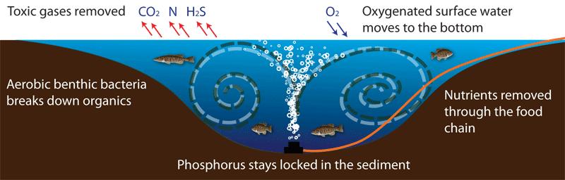
4 Austin Lake South Basin System 27 micro-porous ceramic diffusers from Clean-Flo, Inc. ; Installed by Lake-Savers, Inc. 28,500 feet of self-sinking airline Bacteria and enzyme treatments which consist of 50 gallons of Lake Clear bacteria for nitrogen reduction, 200 gallons of Clean and Clear Enzyme as a catalyst for muck reduction, and 200 lbs of Clean-Flo bacteria for muck reduction. On-land components consist of 3 locally-sourced sheds (Lake- Savers ) and 5.4HP compressors along with cooling fans and ventilation.

5
6 Percentage of total (n=98) sampling sites Austin Lake South Basin EWM Changes due to Aeration + Bio augmentation 16.5 July 2012 (Pre- 5.9 July 2013 (Post- Time 3.9 July 2014 (Post- 0 July 2015 (Post-
7 Changes in Austin Lake South Basin Sediments before and after Inversion Oxygenation Sediment Sediment Sediment Sediment Sampling OM NH3+ Nitrate + Date (%) (mg/kg) Nitrite (mg/kg) Nov 11, ± ± ±59 Nov 13, ± ±52** 3.5±0.1** Means based on n = 24 sediment samples
 Immediate Watershed Area = 5,445 (acres) Shoreline Development Factor = 1.5 Shoreline Length = 4.")
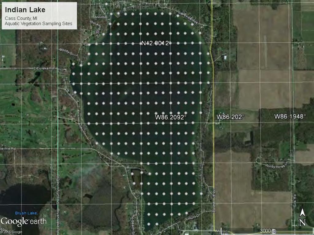
8 Indian Lake, Cass County, MI Surface Area = 499 (acres) Maximum Depth = 28 (ft.) Immediate Watershed Area = 5,445 (acres) Shoreline Development Factor = 1.5 Shoreline Length = 4.84 (miles) Fetch = 1.41 (miles)
9
10 Indian Lake EWM Changes due to Aeration + Bio augmentation Frequency of sampling sites out of June 2012 (Pre June 2013 (Post 2 1 May 2014 (Post August 2015 (Post Time
11 Changes in Indian Lake Sediments before and after Inversion Oxygenation Sediment Sediment Sediment Sediment Sampling OM NH3+ Nitrate + Date (%) (mg/kg) Nitrite (mg/kg) June 15, ±7.2 98±7.6 47±21 August 11, ±5.5 13±4.9** 1.2±0.1** Means based on n = 25 sediment samples


12 Indian Lake Bottom Hardness Changes May 2014 (Pre-aeration) August 2015 (Post-aeration)
13 Changes in Sediment Composition Parameter May August 2015 Net Loss or 2014 Gain Total Sonar Points 16,766 16,765 NA Very Soft Bottom (0-0.15) 0.04% 0.04% 0 Soft Bottom (.15 to.25) 25.5% 0.30% -25.2% Medium Bottom (.25 to.35) % % % Hard Bottom (.35 to.45) % +9.78% % Very Hard Bottom (>.45) 6.37% 11.37% +5.0%
; West Basin = 400")
 Shoreline Length = 14.")
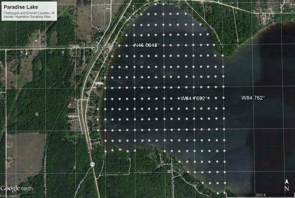
14 Paradise Lake, Emmet & Cheboygan Counties, MI Surface Area = 1,878 acre (acres); West Basin = 400 acres Maximum Depth = 15.1 (ft.) Shoreline Length = 14.3 (miles) Watershed: Lake = 8.9:1 One inlet and one outlet

15 Paradise Lake, September, 2009

")
16 Paradise Lake EWM Canopy (2009)
17
18 70 Paradise Lake EWM Changes due to Aeration + Bio augmentation 62 Frequency of Sampling Sites out of June 2012 (Pre- June 2013 (Post- August 2014 (Post- June 2015 (Post- Time
19 Changes in Paradise Lake Sediments before and after Inversion Oxygenation Sediment Sediment Sediment Sediment Sampling OM NH3+ Nitrate + Date (%) (mg/kg) Nitrite (mg/kg) August 10, ± ± ±12 June 30, ± ±8.8** 2.7±0.9** Means based on n = 12 sediment samples

")
20 Paradise Lake EWM Polygons August 2014 (Post-aeration) June 2015 (Post-aeration)
")
 Shoreline Length = 2.")
21 Pickerel Lake, Kalamazoo County, MI Surface Area = 135 (acres) Maximum Depth = 10 (ft.) Shoreline Length = 2.44 (miles) Fetch = 0.7 (miles)

22
23 120 Pickerel Lake EWM Changes due to Aeration + Bio augmentation Frequency of Sampling Sites out of October 2012 (Pre- June 2013 (Post- August 2015 (Post- Time
 August 2015")
24 Pickerel Lake Aquatic Vegetation Biovolume Changes July 2014 (Pre-aeration) August 2015 (Post-aeration)
25 Pickerel Lake Bottom Hardness Changes July 2014 (Pre-aeration) August 2015 (Post-aeration)
26 Conclusions Each of the 4 studied lakes showed significant reductions in EWM due to aeration + bio augmentation Two of the studied lakes with > 75% reduction in EWM had significant reduction in sediment ammonia, inorganic nitrogen, and % organic matter In Paradise Lake, the EWM polygons were broken up and there was a complete absence of a canopy since aeration began but acreage has declined from 100 acres in the West Basin to currently 58 acres This research suggests possible sediment nitrogen and organic nutrition mechanisms that occur from aeration + bio augmentation which appears to affect the nutrition of milfoil on certain sediment types.
27 Acknowledgements Paradise Lake Improvement Board Austin Lake Governmental Lake Board Indian Lake Improvement Association Pickerel Lake Association Clean-Flo, International, Inc. Lake-Savers, Inc. Nicholas Gressick Grant Jones Kevin Sylvester Dr. Jon Bartholic, Michigan State University
Little Swan Lake. Dam Inspection & Siltation Study Prepared By: William Klingner, P.E., CFM October 28, 2018
 Little Swan Lake Dam Inspection & Siltation Study Prepared By: William Klingner, P.E., CFM October 28, 2018 Agenda Little Swan Lake Dam Inspection Theoretical Little Swan Lake Siltation Rate Calculations
Determining Treatment Areas For Curlyleaf Pondweed and Eurasian Watermilfoil
 Determining Treatment Areas For Curlyleaf Pondweed and Eurasian Watermilfoil (and includes a review of 2 whole lake CLP treatment projects) Steve McComas and Jo Stuckert Blue Water Science November 2010
Great Lakes Update. Volume 199: 2017 Annual Summary. Background
 Great Lakes Update Volume 199: 2017 Annual Summary Background The U.S. Army Corps of Engineers (USACE) tracks and forecasts the water levels of each of the Great Lakes. This report is primarily focused
Sediment Distribution and Characteristics
 Sediment Distribution and Characteristics Sediments at the bottom of ponds are a source or sink for nutrients in relation to the water column, contribute to turbidity during storm events, serve as the
Briggs Lake Water Quality Report 2014
 Briggs Lake Water Quality Report 2014 Seasonal Report for Briggs Lake Green Oak Township, Livingston Co. T1N, R6E, Sec. 3,4 74 Surface Acres 414 Hadley Street Holly, MI 48442 Main Phone: 248-634-8388 Northern
Lake Sedimentation Survey of Siloam Springs State Park Lake, Adams County, Illinois
 Contract Report 567 Lake Sedimentation Survey of Siloam Springs State Park Lake, Adams County, Illinois by Richard L. Allgire Office of Sediment & Wetland Studies Prepared for the Illinois Department of
Second Annual Monitoring Report Tidal Wetland Restoration 159 Long Neck Point Road, Darien, CT NAE
 1) Project Overview Second Annual Monitoring Report Tidal Wetland Restoration 159 Long Neck Point Road, Darien, CT NAE-2007-1130 December 13, 2013 This is the second year of a five year monitoring program
Habitat Monitoring Update Hudson River CAG November 16, 2017
 Habitat Monitoring Update Hudson River CAG November 16, 2017 Habitat Reconstruction Overview: Habitats A habitat replacement program is being implemented in an Adaptive Management context to reconstruct
Aquatic Vegetation Density Mapping BioBase 2015 Report
 Aquatic Vegetation Density Mapping BioBase 2015 Report Written by: Sarah Mielke PLSLWD Monitoring Assistant Edited by: Jaime Rockney, Water Resources Specialist June 2016 Contents Introduction... 1 Objectives...
STREUVER FIDELCO CAPPELLI, LLC YONKERS DOWNTOWN DEVELOPMENT PHASE 1. DRAFT ENVIRONMENTAL IMPACT STATEMENT For: PALISADES POINT
 STREUVER FIDELCO CAPPELLI, LLC YONKERS DOWNTOWN DEVELOPMENT PHASE 1 DRAFT ENVIRONMENTAL IMPACT STATEMENT For: PALISADES POINT Prepared by: PAULUS, SOKOLOWSKI & SARTOR STORMWATER MANAGEMENT 1. Methodology
Survey of Eurasian Watermilfoil (Myriophyllum spicatum) in Gloucester Pool, Port Severn, ON, Canada
 in Gloucester Pool, Port Severn, ON, Canada") Survey of Eurasian Watermilfoil (Myriophyllum spicatum) in Gloucester Pool, Port Severn, ON, Canada Prepared for: Gloucester Pool Cottagers Association Prepared by: Milfoil Solution, Inc. A Canadian Subsidiary
Survey of Eurasian Watermilfoil (Myriophyllum spicatum) in Gloucester Pool, Port Severn, ON, Canada Prepared for: Gloucester Pool Cottagers Association Prepared by: Milfoil Solution, Inc. A Canadian Subsidiary
REDWOOD VALLEY SUBAREA
 Independent Science Review Panel Conceptual Model of Watershed Hydrology, Surface Water and Groundwater Interactions and Stream Ecology for the Russian River Watershed Appendices A-1 APPENDIX A A-2 REDWOOD
Flowering Rush Hand Removal. Lake Minnetonka Pilot Program
 Flowering Rush Hand Lake Minnetonka Pilot Program Spring 2012 Survey Report Provided For the Minnehaha Creek Watershed District By Waterfront Restoration LLC & Blue Water Science May 31, Waterfront Restoration,
Steven Noble MDEQ - WRD Enbridge Response Unit
 EPA situation report, October 19, 2012 Steven Noble MDEQ - WRD Enbridge Response Unit Brief history of the spill Monitoring Monitoring the impacts Follow the oil The Current Situation A Look at the Future
Great Lakes Update. Volume 188: 2012 Annual Summary
 Great Lakes Update Volume 188: 2012 Annual Summary Background The U.S. Army Corps of Engineers (USACE) tracks the water levels of each of the Great Lakes. This report highlights hydrologic conditions of
Low-flow Estimates for Cedar Creek at Galesburg, Illinois
 ISWS CR 587 ntract Report 587 Low-flow Estimates for Cedar Creek at Galesburg, Illinois by Krishan P. Singh and Robert S. Larson Office of Surface Water Resources: Systems, Information & GIS Prepared for
LOCATED IN INDIAN RIVER COUNTY PREPARED FOR S.J.R.W.M.D. AND F.W.C.D. DECEMBER, 2003 Updated 2007 Updated May 2014 PREPARED BY
 FELLSMERE WATER CONTROL DISTRICT EAST MASTER DRAINAGE PLAN AND STORMWATER HYDROLOGIC ANALYSIS OF THE GRAVITY DRAINAGE SYSTEM LOCATED BETWEEN THE EAST BOUNDARY, LATERAL U, THE MAIN CANAL, AND DITCH 24 LOCATED
Great Lakes Update. Volume 194: 2015 Annual Summary
 Great Lakes Update Volume 194: 2015 Annual Summary Background The U.S. Army Corps of Engineers (USACE) tracks and forecasts the water levels of each of the Great Lakes. This report summarizes the hydrologic
9/12/2014 O V E RV I E W
 K E E P I N G T H E N E W M I S S I O N R E AC H C L E A N T R A S H & F L O ATA B L E S B M P S T U D Y Russell Persyn, P.E., Ph.D. (SARA) Cris Parker, P.E., CFM (HDR) September 4, 2014 O V E RV I E W»
The Comedy of Crystal Lake: GIS Analysis of an Unique Historical Event Using Original Survey and Project Maps
 The Comedy of Crystal Lake: GIS Analysis of an Unique Historical Event Using Original Survey and Project Maps Dr. Stacy Leroy Daniels IMAGIN: Mapping the Mitten Traverse City, MI, 16 May 2016 ARCHIBALD
Third Annual Monitoring Report Tidal Wetland Restoration 159 Long Neck Point Road, Darien, CT NAE
 1) Project Overview Third Annual Monitoring Report Tidal Wetland Restoration 159 Long Neck Point Road, Darien, CT NAE-2007-1130 December 15, 2014 This is the third year of a five year monitoring program
President s Day Weekend Storm Community Meeting and Workshop April 17, 2017
 President s Day Weekend Storm Community Meeting and Workshop April 17, 2017 Meeting outline 1. Progress update on the City of San Jose s recovery efforts 2. Water district presentation on: Weather situation
NORTHUMBERLAND COUNTY, PA
 QUAKER RUN Stream and Wetland Restoration As-Built Completion Report and First Year Monitoring Data Coal Township NORTHUMBERLAND COUNTY, PA Upstream Before Upstream After Prepared for: COAL TOWNSHIP 805
SEAGRASS COVERAGE TRENDS IN THE INDIAN RIVER LAGOON SYSTEM
 Biological Sciences SEAGRASS COVERAGE TRENDS IN THE INDIAN RIVER LAGOON SYSTEM R. W. VIRNSTEIN *,J.S.STEWARD, AND L. J. MORRIS St. Johns River Water Management District, Palatka, FL 32178 ABSTRACT: We
PH YSIC A L PROPERT IE S TERC.UCDAVIS.EDU
 PH YSIC A L PROPERT IE S 8 Lake surface level Daily since 1900 Lake surface level varies throughout the year. Lake level rises due to high stream inflow, groundwater inflow and precipitation directly onto
ATTACHMENT A WEAVER BOTTOMS SEDIMENT BASIN MAINTENANCE PROJECT PROJECT REPORT SUMMARY (APRIL 7, 2014)
") ATTACHMENT A WEAVER BOTTOMS SEDIMENT BASIN MAINTENANCE PROJECT PROJECT REPORT SUMMARY (APRIL 7, 2014) PRE-PROJECT DREDGE MATERIAL SEDIMENT CORE AND BASELINE CONTAMINANT ANALYSIS PREPARED BY BRAUN INTERTEC
ATTACHMENT A WEAVER BOTTOMS SEDIMENT BASIN MAINTENANCE PROJECT PROJECT REPORT SUMMARY (APRIL 7, 2014) PRE-PROJECT DREDGE MATERIAL SEDIMENT CORE AND BASELINE CONTAMINANT ANALYSIS PREPARED BY BRAUN INTERTEC
Soils in Minnesota Calcareous Fens
 Soils in Minnesota Calcareous Fens MGWA TECHNICAL WORKSHOP June 18, 2004 George Poch 6/23/2004 1 Introduction Our presentation today is to show What soils are in the Fen areas How they have been mapped
Illinois State Water Survey Division
 Illinois State Water Survey Division SURFACE WATER SECTION SWS Contract Report 413 AT THE UNIVERSITY OF ILLINOIS SEDIMENTATION SURVEY OF DAWSON LAKE, MORAINE VIEW STATE PARK, MC LEAN COUNTY, ILLINOIS by
Kaskaskia Morphology Study Headwaters to Lake Shelbyville
 Kaskaskia Morphology Study Headwaters to Lake Shelbyville KWA Mini Summit 5 March 2012 1 Kaskaskia Morphology Study Headwaters to Lake Shelbyville Conducted by U.S. Army Corps of Engineers, St. Louis District
Lecture 6: Precipitation Averages and Interception
 Lecture 6: Precipitation Averages and Interception Key Questions 1. How much and when does Whatcom County receive rain? 2. Where online can you find rainfall data for the state? 3. How is rainfall averaged
2012 Rainfall, Runoff, Water Level & Temperature Beebe Lake Wright County, MN (# )
") www.fixmylake.com 18029 83 rd Avenue North Maple Grove, MN 55311 mail@freshwatersci.com (651) 336-8696 2012 Rainfall, Runoff, Water Level & Temperature Beebe Lake Wright County, MN (#86-0023) Prepared
www.fixmylake.com 18029 83 rd Avenue North Maple Grove, MN 55311 mail@freshwatersci.com (651) 336-8696 2012 Rainfall, Runoff, Water Level & Temperature Beebe Lake Wright County, MN (#86-0023) Prepared
Measuring Planet Earth Regents Review. 2. State the altitude of Polaris as seen by an observer at the North Pole.
 Name Measuring Planet Earth Regents Review ase your answers to questions 1 through 3 on the diagram below, which represents a north polar view of Earth on a specific day of the year. Solar times at selected
Stream Discharge and the Water Budget
 Regents Earth Science Unit 6: Water Cycle & Climate Name: Lab # Stream Discharge and the Water Budget Introduction: The United States Geological Survey (USGS) measures and publishes values for the daily
Great Lakes Update. Volume 191: 2014 January through June Summary. Vol. 191 Great Lakes Update August 2014
 Great Lakes Update Volume 191: 2014 January through June Summary The U.S. Army Corps of Engineers (USACE) monitors the water levels of each of the Great Lakes. This report provides a summary of the Great
Assessing Michigan s Biological diversity. Michigan Natural Features Inventory MSU Extension
 Assessing Michigan s Biological diversity John Paskus,, Amy Derosier,, Edward Schools, and Helen Enander Michigan Natural Features Inventory MSU Extension Goal Provide scientifically based information
Bathymetric Survey and Sediment Hydroacoustic Study of Canyon Lake. Michael Anderson UC Riverside
 Bathymetric Survey and Sediment Hydroacoustic Study of Canyon Lake Michael Anderson UC Riverside Introduction Canyon Lake was constructed in 1928 as the Railroad Canyon Reservoir as a result of the impoundment
Sediment and Carp Dynamics in Lake Mendota s Yahara River Estuary
 Sediment and Carp Dynamics in Lake Mendota s Yahara River Estuary Final project report for DNR Lake Planning Grant to Dane County with subcontract to UW Madison; Submitted April 4, 2013 Prof. Chin Wu (Project
Simulating the groundwater discharge to wetlands. Mukwonago Basin Example and Potential Application in Dane County
 Simulating the groundwater discharge to wetlands Mukwonago Basin Example and Potential Application in Dane County Conceptual Model Topography is major control on flow to wetlands Land Surface Water Table
Illinois Drought Update, December 1, 2005 DROUGHT RESPONSE TASK FORCE Illinois State Water Survey, Department of Natural Resources
 Illinois Drought Update, December 1, 2005 DROUGHT RESPONSE TASK FORCE Illinois State Water Survey, Department of Natural Resources For more drought information please go to http://www.sws.uiuc.edu/. SUMMARY.
+ 3H 2 2NH 3. Complete the sentence. [1 mark] The forward reaction is exothermic, so the reverse reaction is. ). Relative atomic masses (A r
![+ 3H 2 2NH 3. Complete the sentence. [1 mark] The forward reaction is exothermic, so the reverse reaction is. ). Relative atomic masses (A r](/thumbs/93/113873354.jpg "+ 3H 2 2NH 3. Complete the sentence. [1 mark] The forward reaction is exothermic, so the reverse reaction is. ). Relative atomic masses (A r") 2 6 This question is about ammonia and fertilisers. 6 (a) Ammonia is produced by a reversible reaction. The equation for the reaction is: N 2 + 3H 2 2NH 3 Complete the sentence. The forward reaction is
2 6 This question is about ammonia and fertilisers. 6 (a) Ammonia is produced by a reversible reaction. The equation for the reaction is: N 2 + 3H 2 2NH 3 Complete the sentence. The forward reaction is
MICHIGAN GEOLOGICAL SURVEY Coastal Navigator Training St. Joseph, Michigan What do we know about anthropogenic impact(s) to Lake Michigan shorelines?
 to Lake Michigan shorelines?") MICHIGAN GEOLOGICAL SURVEY Coastal Navigator Training St. Joseph, Michigan What do we know about anthropogenic impact(s) to Lake Michigan shorelines? Review of a 12 year shoreline study and today, what
MICHIGAN GEOLOGICAL SURVEY Coastal Navigator Training St. Joseph, Michigan What do we know about anthropogenic impact(s) to Lake Michigan shorelines? Review of a 12 year shoreline study and today, what
Island Design. UMRS EMP Regional Workshop. Presentation for the
 Island Design Presentation for the UMRS EMP Regional Workshop by Jon Hendrickson Hydraulic Engineer Regional Technical Specialist, Water Quality and Habitat Restoration August 17 19, 2005 Project Delivery
Current Climate Trends and Implications
 Current Climate Trends and Implications Dr. Mark Seeley Professor emeritus Department of Soil, Water, and Climate University of Minnesota St Paul, MN 55108 Crop Insurance Conference September 12, 2018
Earth Science Regents Reading Topographic Maps
 Earth Science Regents Reading Topographic Maps Name Period Quick Tutorial on Degrees, Minutes, and Seconds of Latitude and Longitude A degree of latitude on the surface of the earth is about 70 miles long.
International Journal of Agriculture and Environmental Research
 EVALUATION OF THE QUANTITY AND QUALITY OF RUNOFF WATER FROM A STRAWBERRY RANCH SLOPING GROUND DURING WINTER STORM EVENTS IN THE CALIFORNIA CENTRAL COAST Gerardo Spinelli 1*, Sacha Lozano 1, Ben Burgoa
The Effect of the No-Burn Ban on the Economic Viability of Producing Bluegrass Seed in Select Areas of Washington State
 Farm Business Management Reports EB1922E The Effect of the No-Burn Ban on the Economic Viability of Producing Bluegrass Seed in Select Areas of Washington State Herbert R. Hinman Alan Schreiber Online
Great Lakes Update. Volume 193: 2015 January through June Summary. Vol. 193 Great Lakes Update August 2015
 Great Lakes Update Volume 193: 2015 January through June Summary The U.S. Army Corps of Engineers (USACE) monitors the water levels of each of the Great Lakes. This report provides a summary of the Great
Potential Restorable Wetlands (PRWs):
:") ASWM Webinar Sept. 17, 2014 Potential Restorable Wetlands (PRWs): Working definition: wetland hydrology and soils minus presently mapped wetlands for the re-establishment of wetlands Hydric Soil Query
ASWM Webinar Sept. 17, 2014 Potential Restorable Wetlands (PRWs): Working definition: wetland hydrology and soils minus presently mapped wetlands for the re-establishment of wetlands Hydric Soil Query
Lake-Level Variability and Water Availability in the Great Lakes
 National Water Availability and Use Program Lake-Level Variability and Water Availability in the Great Lakes Circular 1311 U.S. Department of the Interior U.S. Geological Survey Front-cover photo: Drowned-river-mouth
Detroit 516 Activities
 Detroit 516 Activities Dam Capacity Study Sediment Workshop in Traverse City START 2.0 Saginaw River Study Dam Capacity Study A progress report Outline Study Objective (Why are we doing this?) Reservoir
An investigation of sampling efficiency using historical data. Patrick Didier Advisor: Justine Blanford
 An investigation of sampling efficiency using historical data Patrick Didier Advisor: Justine Blanford Overview Introduction to Airborne Snow Survey program Goals of the Capstone Project Methods and Expected
Laboratory Exercise #3 The Hydrologic Cycle and Running Water Processes
 Laboratory Exercise #3 The Hydrologic Cycle and Running Water Processes page - 1 Section A - The Hydrologic Cycle Figure 1 illustrates the hydrologic cycle which quantifies how water is cycled throughout
Chapter 3 - White Oak River Subbasin Includes Bogue Sound and the Newport River
 Chapter 3 - White Oak River Subbasin 03-05-03 Includes Bogue Sound and the Newport River 3.1 Water Quality Overview Subbasin 03-05-03 at a Glance Land and Water Area (sq. mi.) Total area: 228 Land area:
Sources of Sediment and Trace Metals to Lake Worth Lagoon
 Downstream of S155 Structure, September 7, 2008 Sources of Sediment and Trace Metals to Lake Worth Lagoon John H. Trefry and Robert P. Trocine Florida Institute of Technology LWL Symposium, PBAU, May 15,
Citizen Science Actions AIS Shoreline Survey Blocking Zebra Mussels Ice in, Ice off. Janet Andersen
 Citizen Science Actions AIS Shoreline Survey Blocking Zebra Mussels Ice in, Ice off Janet Andersen Shoreline search for new Aquatic Invasive Plants NYS DEC NYSFOLA Janet Andersen Shoreline Search Topics
CHERRY HILL TUITION AQA BIOLOGY A2 PAPER 21. Complete the table with a tick if the statement in the first column is true, for each process.
 2 Answer all questions in the spaces provided. 1 (a) The table contains statements about three biological processes. Complete the table with a tick if the statement in the first column is true, for each
Jackson County 2013 Weather Data
 Jackson County 2013 Weather Data 61 Years of Weather Data Recorded at the UF/IFAS Marianna North Florida Research and Education Center Doug Mayo Jackson County Extension Director 1952-2008 Rainfall Data
MICROCOMPUTER CROP COST AND RETURN GENERATOR
 MICROCOMPUTER CROP AND RETURN GENERATOR BUDGET AREA... VALENCIA AND SOUTHERN BERNALILLO COUNT FARM SIZE.... 30.00 ACRES IRRIGATION TYPE FLOOD NUMBER OF CROPS 5 VERSION 1.0 COPYRIGHT (C) 1984 by NEW MEXICO
TSEGI WASH 50% DESIGN REPORT
 TSEGI WASH 50% DESIGN REPORT 2/28/2014 Daniel Larson, Leticia Delgado, Jessica Carnes I Table of Contents Acknowledgements... IV 1.0 Project Description... 1 1.1 Purpose... 1 Figure 1. Erosion of a Headcut...
Assessment of Lake Forest Lake Sediment Trapping Efficiency and Capacity. Marlon R. Cook Groundwater Assessment Program Geological Survey of Alabama
 Assessment of Lake Forest Lake Sediment Trapping Efficiency and Capacity Marlon R. Cook Groundwater Assessment Program Geological Survey of Alabama Impacts of the Lake at Lake Forest on the connectivity
9. PROBABLE MAXIMUM PRECIPITATION AND PROBABLE MAXIMUM FLOOD
 9. PROBABLE MAXIMUM PRECIPITATION AND PROBABLE MAXIMUM FLOOD 9.1. Introduction Due to the size of Watana Dam and the economic importance of the Project to the Railbelt, the Probable Maximum Flood (PMF)
Adam Munson, Environmental Scientist III Resource Conservation and Development Department Southwest Florida Water Management District
 April 27, 2004 MEMORANDUM TO: FROM: File Adam Munson, Environmental Scientist III Resource Conservation and Development Department Southwest Florida Water Management District SUBJECT: Proposed minimum
Reducing Nitrogen Removal Uncertainty for Operation of Mississippi River Sediment Diversions: Nitrate Reduction Rates In Turbulent Flow Conditions
 Reducing Nitrogen Removal Uncertainty for Operation of Mississippi River Sediment Diversions: Nitrate Reduction Rates In Turbulent Flow Conditions Nia R. Hurst, John R. White, Kehui Xu, and MingCheng Ren
Influence of the Major Drainages to the Mississippi River and Implications for System Level Management
 Influence of the Major Drainages to the Mississippi River and Implications for System Level Management Brian M. Vosburg Geologist Louisiana Coastal Protection and Restoration Authority brian.vosburg@la.gov
BIOL 695 NITROGEN. Chapter 7 MENGEL et al, 5th Ed NITROGEN CYCLE. Leaching
 BIOL 695 NITROGEN Chapter 7 MENGEL et al, 5th Ed NITROGEN CYCLE Leaching INDUSTRIAL N FIXATION High energy requirement Haber-Bosch Process Natural gas - High Temperature & pressure N 2 + 3H 2 2 NH 3 BIOLOGICAL
Stormwater Guidelines and Case Studies. CAHILL ASSOCIATES Environmental Consultants West Chester, PA (610)
") Stormwater Guidelines and Case Studies CAHILL ASSOCIATES Environmental Consultants West Chester, PA (610) 696-4150 www.thcahill.com Goals and Challenges for Manual State Stormwater Policy More Widespread
Stormwater Guidelines and Case Studies CAHILL ASSOCIATES Environmental Consultants West Chester, PA (610) 696-4150 www.thcahill.com Goals and Challenges for Manual State Stormwater Policy More Widespread
Section B - Chapter 13 Neuse River Subbasin Bay River and Pamlico Sound
 Section B - Chapter 13 Neuse River Subbasin 3-4-13 Bay River and Pamlico Sound 13.1 Subbasin Overview Subbasin 3-4-13 at a Glance Land and Water Area Total area: 277 mi 2 Land area: 145 mi 2 Water area:
HELSINKI COMMISSION HELCOM MONAS 4/2002 Monitoring and Assessment Group Fourth Meeting Warnemünde, Germany, October 2002
 HELSINKI COMMISSION HELCOM MONAS 4/2002 Monitoring and Assessment Group Fourth Meeting Warnemünde, Germany, 21-25 October 2002 Agenda Item X Document code: Date: Submitted by: To be filled in by the Secretariat
PHYSICAL PROPERTIES TAHOE.UCDAVIS.EDU 8
 PHYSICAL PROPERTIES 8 Lake surface level Daily since 1900 Lake surface level varies throughout the year. Lake level rises due to high stream inflow, groundwater inflow, and precipitation directly onto
Seagrass Transplantation & Environmental & Marine Consulting Services, Inc. Drew Campbell, Vice President & Lead Scientst.
 Indian River Lagoon Symposium Seagrass Transplantation & Project Considerations Environmental & Marine Consulting Services, Inc. Drew Campbell, Vice President & Lead Scientst March 26 th, 2013 Regulatory
Climate Variability. Eric Salathé. Climate Impacts Group & Department of Atmospheric Sciences University of Washington. Thanks to Nathan Mantua
 Climate Variability Eric Salathé Climate Impacts Group & Department of Atmospheric Sciences University of Washington Thanks to Nathan Mantua Northwest Climate: the mean Factors that influence local/regional
The Weed Battle. Sage Fitch, Salt Lake County Weed Specialist
 The Weed Battle Noxious and Invasive Weed Management by The Salt Lake County Weed Program and The Bonneville CWMA Sage Fitch, Salt Lake County Weed Specialist Our program & our partners Who are we and
Materials. Use materials meeting the following.
 208.01 Section 208. SOIL EROSION AND SEDIMENTATION CONTROL 208.01 Description. Install and maintain erosion and sedimentation controls to minimize soil erosion and to control sedimentation from affecting
Roger Andy Gaines, Research Civil Engineer, PhD, P.E.
 Roger Andy Gaines, Research Civil Engineer, PhD, P.E. Research Civil Engineer/Regional Technical Specialist Memphis District August 24, 2010 Objectives Where we have been (recap of situation and what s
Long-term Water Quality Monitoring in Estero Bay
 Long-term Water Quality Monitoring in Estero Bay Keith Kibbey Laboratory Director Lee County Environmental Laboratory Division of Natural Resource Management Estero Bay Monitoring Programs Three significant
Sun. Photosynthesis (performed by plants, algae, and some bacteria) Respiration (performed by all organisms) 6 O 2 6 CO 2.
 Respiration (performed by all organisms) 6 O 2 6 CO 2.") Photosynthesis (performed by plants, algae, and some bacteria) Sun 6 O 6 CO 6 H O C 6 H O 6 (glucose) Solar energy + 6 H O + 6 CO C 6 H O 6 + 6 O Energy Respiration (performed by all organisms) 6 O 6 CO
Photosynthesis (performed by plants, algae, and some bacteria) Sun 6 O 6 CO 6 H O C 6 H O 6 (glucose) Solar energy + 6 H O + 6 CO C 6 H O 6 + 6 O Energy Respiration (performed by all organisms) 6 O 6 CO
A Review of the 2007 Water Year in Colorado
 A Review of the 2007 Water Year in Colorado Nolan Doesken Colorado Climate Center, CSU Mike Gillespie Snow Survey Division, USDA, NRCS Presented at the 28 th Annual AGU Hydrology Days, March 26, 2008,
Natural Shoreline Landscapes on Michigan Inland Lakes
 Natural Shoreline Landscapes on Michigan Inland Lakes Excerpts from Chapters 2 and 3 Photo Photo by Jane by Jane Herbert Herbert Session topics Characteristics of natural and altered shorelines Lakes,
LAKE SURVEY REPORT. Fisheries Management. DOW Number: Survey ID Date: 07/31/2017. Lake Identification. Lake Location. Legal Descriptions
 Fisheries Management LAKE SURVEY REPORT Lake Name: Kroon Survey Type: Targeted Survey DOW Number: 13-0013-00 Survey ID Date: 07/31/2017 Lake Identification Alternate Lake Name: N/A Primary Lake Class ID:
Rocky Mountain Field Institute 2015 Annual Report Waldo Canyon Fire Restoration December 17, 2015
 December 17, 2015 815 South 25 th St, Suite 101 Colorado Springs, CO 80904 www.rmfi.org Dedicated to the conservation and stewardship of public lands in the Pikes Peak Region 2 Background In the summer
b. What is the length, width (ft), and direction of flow of Seafield Lake?
, and direction of flow of Seafield Lake?") FOR 274 Assignment 3 [50 points] Name: Section: This assignment should be completed and handed in to the assignment box in the Forest Resources office by noon on Monday 17th of September. Partial credit
FOR 274 Assignment 3 [50 points] Name: Section: This assignment should be completed and handed in to the assignment box in the Forest Resources office by noon on Monday 17th of September. Partial credit
WIND EFFECTS ON CHEMICAL SPILL IN ST ANDREW BAY SYSTEM
 WIND EFFECTS ON CHEMICAL SPILL IN ST ANDREW BAY SYSTEM PETER C. CHU, PATRICE PAULY Naval Postgraduate School, Monterey, CA93943 STEVEN D. HAEGER Naval Oceanographic Office, Stennis Space Center MATHEW
2017 Aquatic Plant Survey: Silver Lake (WBIC# )
") Aquatic Plants in Silver Lake; Hennepin County, MN August 07 577 Creekside Lane Osseo, MN 5569 james@freshwatersci.com (65) 6-8696 07 Aquatic Plant Survey: Silver Lake (WBIC# 7-06-00) Surveyed August,
Aquatic Plants in Silver Lake; Hennepin County, MN August 07 577 Creekside Lane Osseo, MN 5569 james@freshwatersci.com (65) 6-8696 07 Aquatic Plant Survey: Silver Lake (WBIC# 7-06-00) Surveyed August,
Bank Erosion and Morphology of the Kaskaskia River
 Bank Erosion and Morphology of the Kaskaskia River US Army Corps Of Engineers St. Louis District Fayette County Soil and Water Conservation District Team Partners : Carlyle Lake Ecosystem Partnership Vicinity
Minimizing Flood Risks and Habitat Impacts Due to Post-Flood Recovery Efforts
 Minimizing Flood Risks and Habitat Impacts Due to Post-Flood Recovery Efforts Roy Schiff, Milone & MacBroom, Inc. Mike Kline, Vermont Agency of Natural Resources Shayne Jaquith, Vermont Agency of Natural
MI : Lake Miccosukee. Leon County Lakes 2006 Sean McGlynn. PhD. Page 1 of 14
 Leon County Lakes Ecology Lake Miccosukee McGlynn Labs Inc. 5.2.1: Lake Miccosukee Surface Area: 6312 acres @ 80' MSL Number of Stations:1 Duration of monitoring:10/99-06/06 Page 1 of 14 MI1 Figure 5.2.1:
Climatic Change Implications for Hydrologic Systems in the Sierra Nevada
 Climatic Change Implications for Hydrologic Systems in the Sierra Nevada Part Two: The HSPF Model: Basis For Watershed Yield Calculator Part two presents an an overview of why the hydrologic yield calculator
Rainfall Observations in the Loxahatchee River Watershed
 Rainfall Observations in the Loxahatchee River Watershed Richard C. Dent Loxahatchee River District September 1997 Introduction Rain is a common occurrence in south Florida, yet its presence or absence
DRAFT. REVISED Draft. Paso Robles Subbasin Groundwater Sustainability Plan Chapter 6
 REVISED Draft Paso Robles Subbasin Groundwater Sustainability Plan Chapter 6 Prepared for the Paso Robles Subbasin Cooperative Committee and the Groundwater Sustainability Agencies February 14, 2019 Paso
Project No India Basin Shadow Study San Francisco, California, USA
 Project No. 432301 India Basin Shadow Study San Francisco, California, USA Numerical Modelling Studies 04 th June 2018 For Build Inc. Report Title: India Basin Shadow Study San Francisco, California, USA
Section 4: Model Development and Application
 Section 4: Model Development and Application The hydrologic model for the Wissahickon Act 167 study was built using GIS layers of land use, hydrologic soil groups, terrain and orthophotography. Within
Black Gore Creek 2013 Sediment Source Monitoring and TMDL Sediment Budget
 Black Gore Creek 2013 Sediment Source Monitoring and TMDL Sediment Budget Prepared for: Prepared By: - I. Introduction The Black Gore Creek Total Maximum Daily Load (TMDL) was developed in collaboration
Using GIS for Watershed Protection and Management
 Using GIS for Watershed Protection and Management New York Federation of Lake Association 2014 Conference, Celebrating Lake Stewardship May 2-4, 2014 Robert N. Brower, CEO IAGT Using GIS for Watershed
Schuyler County Idle Farmland Analysis. Conducted by Cornell Cooperative Extension of Schuyler County
 Schuyler County Idle Farmland Analysis Conducted by Cornell Cooperative Extension of Schuyler County June 15, 2010 Schuyler County Idle Farmland Analysis Purpose: The purpose of this analysis is to approximate
Chemistry 400: General Chemistry Sacramento City College HW#1: Review to Begin Chemistry 400. Review of Chapter 1
 Chemistry 400: General Chemistry Sacramento City College HW#1: Review to Begin Chemistry 400 Review of Chapter 1 1) Identify a liquid. A) definite volume and definite shape B) definite volume and no definite
Aquatic Plant Community in Rice Lake: 2014 Hennepin County, MN (# )
") www.fixmylake.com 809 8 rd Avenue orth Maple Grove, M 55 mail@freshwatersci.com (65) 6-8696 Aquatic Plant Community in Rice Lake: 0 Hennepin County, M (#7-06) Surveyed July 5, 0 Surveying, Analysis, and
www.fixmylake.com 809 8 rd Avenue orth Maple Grove, M 55 mail@freshwatersci.com (65) 6-8696 Aquatic Plant Community in Rice Lake: 0 Hennepin County, M (#7-06) Surveyed July 5, 0 Surveying, Analysis, and
Natural Variability in Annual Maximum Water Level and Outflow of Yellowstone Lake
 Natural Variability in Annual Maximum Water Level and Outflow of Yellowstone Lake Phillip E. Farnes Abstract The water level in Yellowstone Lake varies each year in response to differences in the winter
N 2 3. Lake Huron. St. Clair River. Black River Assessment. Figure 1. Major tributaries to the Black River. 1. Berry Drain 2. Elk Creek.
 1. Berry Drain 2. Elk Creek Deckerville 3. Arnot Creek 4. Black Creek 5. Silver Creek 6. Plum Creek 7. Mill Creek 1 Sandusky Carsonville 8. Stocks Creek Applegate N 2 3 Croswell Peck 0 5 10 Brown City
Chapter 5. The Biogeochemical Cycles. Botkin & Keller Environmental Science 5e
 Chapter 5 The Biogeochemical Cycles How Chemicals Cycle Biogeochemical Cycle The complete path a chemical takes through the four major components or reservoirs of Earth s systems 1. Atmosphere 2. Hydrosphere
FORCES ON EARTH UNIT 3.2. An investigation into how Newton s Laws of Motion are applied to the tectonic activity on Earth.
 FORCES ON EARTH UNIT 3.2 An investigation into how Newton s Laws of Motion are applied to the tectonic activity on Earth. USE THESE NOTES: OUR HOME PLANET EARTH: What do you know about our planet? SO.HOW