Using GIS for Watershed Protection and Management
|
|
|
- Rebecca Monica White
- 6 years ago
- Views:
Transcription
1 Using GIS for Watershed Protection and Management New York Federation of Lake Association 2014 Conference, Celebrating Lake Stewardship May 2-4, 2014 Robert N. Brower, CEO IAGT
2 Using GIS for Watershed Protection and Management A Brief Description of GIS and GIT The Watershed Protection and Management Process and Stewardship Managing the Lake and Watershed with GIS/GIT A Range of Applications
3 Using GIS for Watershed Protection and Management A Brief Description of GIS and GIT The Watershed Protection and Management Process and Stewardship Managing the Lake and Watershed with GIS/GIT A Range of Applications
 through education, outreach and innovative applications.")

4 IAGT Mission Quick Review help communities and society realize the benefits of Geospatial Information Technologies (GIT) through education, outreach and innovative applications. IAGT meshes the strengths of GPS, remote sensing, aerial photography digital mapping, geospatial data, visualization applications, and web-based technologies into customized solutions and decision support tools for business, educators, and government agencies.
5 Using GIS for Watershed Protection and Management A Brief Description of GIS and GIT Geospatial data is information that identifies the geographic location and characteristics of natural or constructed features and boundaries on the earth, typically represented by points, lines, polygons, and/or complex geographic features.
6 Using GIS for Watershed Protection and Management Analysis and Integration Definition of Issue Derivation of Spatial Data Capture of Data Location of Data
7 Using GIS for Watershed Protection and Management A Brief Description of GIS and GIT About 770,000 results (0.78 seconds) 1. tableausoftware.com Adwww.tableausoftware.com/ has 2,641 followers on Google+ 2.. GPSNavX for Mac - gpsnavx.com 3. Welcome to the QGIS project! A Free and Open Source Geographic Information System... Create, edit, visualise, analyse and publish geospatial information on Windows, Mac, Linux, BSD... Download - Documentation - QGIS Plugins planet - Discover QGIS 4. GRASS GIS - Home 5.
8 Using GIS for Watershed Protection and Management A Brief Description of GIS and GIT The Watershed Protection and Management Process and Stewardship Managing the Lake and Watershed with GIS/GIT A Range of Applications (5 minutes)
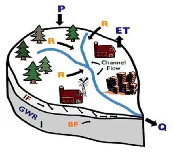
9 Using GIS for Watershed Protection and Management The Watershed Protection and Management Process What is a watershed? A watershed is an area of land that drains into a body of water, such as a lake, river, reservoir, estuary, sea or ocean. The watershed includes both the streams and rivers that convey the water, and the land from which the water runs off. Watersheds are separated from adjacent watersheds by high points such as ridges, hills and mountains.

10 Watershed/Landscape Model Barry M. Evans, PhD.
11 Using GIS for Watershed Protection and Management The Watershed Protection and Management Process The Division of Water, Watershed Management Cycle, NYSDEC
12 Using GIS for Watershed Protection and Management Watershed Stewardship - Taking action to help preserve and protect our water resources. NYSDEC website Stewardship - protectorship, guardianship, custodianship Under the noun Protection in Roget s Thesaurus,
13 Using GIS for Watershed Protection and Management The Penn State Master Watershed Steward program was established to strengthen local capacity for management and protection of watersheds, streams, and rivers, by educating and empowering volunteers across the commonwealth.
14 Using GIS for Watershed Protection and Management Example projects include: Organizing educational and informational workshops for the public, students and municipal officials on topics such as rain barrels, wildlife, pollution prevention, stormwater management, and invasive plant control Organizing and executing stream clean ups Designing and installing demonstration rain gardens Monitoring streams for bacteria Carrying out stream bank restoration projects
15 Using GIS for Watershed Protection and Management A Brief Description of GIS and GIT The Watershed Protection and Management Process and Stewardship Managing the Lake and Watershed with GIS/GIT A Range of Applications
16 Using GIS for Watershed Protection and Management The Watershed Protection and Management Process Assessment Planning & Management Monitoring The Division of Water, Watershed Management Cycle, NYSDEC
17 Using GIS for Watershed Protection and Management The Watershed Protection and Management Process Assessment 1. Nutrient Allocation Models 2. Invasive Species Survey 3. Watershed Land Value Assessment The Division of Water, Watershed Management Cycle, NYSDEC

18 Estimation of Nutrient Loads to Owasco Lake Barry M. Evans Penn State Institutes of Energy and the Environment University Park PA

19 Barry M. Evans
20 Barry M. Evans

21 l Owasco Lake / Watershed Water Quality Trophic Status Owasco Lake OWN IT State of the Lake Conference March 1, 2014 John D Halfman Environmental Studies Program Department of Geoscience Finger Lakes Institute
 Net (t/y) 2011 15 2.4 12 2012 1.9 1.6-1.8 2013 3.1 (8.4) 5.9-2.8 (3.")
22 Phosphoru s Budget Past Three Years Year Stream Input (tons/year) Output (t/y) Net (t/y) (8.4) (3.5)

23 Summary Rain Intensity/Totals Critical to Stream Delivery of: Phosphates Suspended Sediments Sources Agricultural Runoff Events Stream Bank Erosion More Effort Required Wastewater Treatment Facilities Continuous Septics
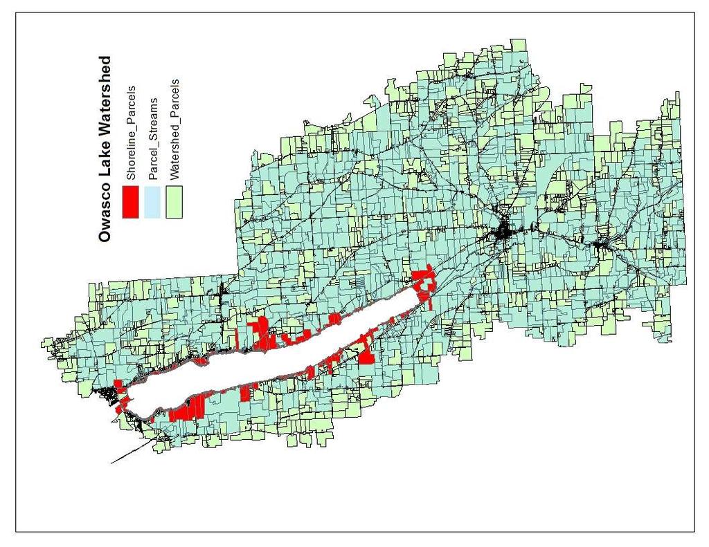
24 Community Mapping and The Land Value Analysis Some Preliminary Findings Based on Student GIS Analysis of the Land Value of the Cayuga County Portion of the Owasco Lake Watershed
25 The Community Mapping Program Mike Gordon, SUNY Cortland Tim McKillen, SUNY Cortland Rusty Ingerson, CCC Corrine Murray, LaMoyne Nick Topichak, CCC,Virginia Tech Jason MacLeod, Festa Fellow, SUNY Oswego

26 Assessed Land Value of the Parcels


27 Assessed Land Value Shoreline Only

28 Assessed Market Value (Per Acre)

29 Assessed Land Value and HUC s
30 Using GIS for Watershed Protection and Management Tax Parcel Findings on land taxes 52% of all parcels in the Cayuga County Portion of the Owasco Lake Watershed are Agricultural There is one land based exemption in the data: Agricultural Land Exemption Lowest agricultural land exemption $ Highest agricultural land exemption $528,339.00
31 Using GIS for Watershed Protection and Management Tax Parcel Findings on land taxes Total agricultural land exemptions for parcels in the Cayuga County Portion of the Owasco Lake Watershed $37,578,064 (53% annually) Average Agricultural exemption amount for area studied $51, Total taxes paid on land in area studied $31,659, (47% annually) There is $5,918, more in land exemptions than taxes paid in the area studied. (annually)
32
33 Using GIS for Watershed Protection and Management The Watershed Protection and Management Process Planning & Manage. 1. Nutrient and Sediment Reduction Efforts 2. Wetlands Planning and Stakeholder Survey The Division of Water, Watershed Management Cycle, NYSDEC

34 Sediment and Nutrient Loading Goal, Objective, and Strategies Report to the Cayuga County Water Quality Management Agency by the Sediment and Nutrient Loading Reduction Working Group March 7, 2013

35 Goal: Reduce sediment and nutrient loadings in waterbodies where problems or impacts caused by sediment and nutrients are apparent, and prevent excess loadings in all other waterbodies across the County Objective: Support the application of best management practices to treat or reduce causal factors of sediment and nutrient loading in areas and situations where they will have the greatest effect.


36 SEDIMENT AND NUTRIENT LOADING Nutrient Loading Potential of Subwatersheds Relative differences in the nutrient loading potential of hydrological units at a certain scale may be reliably estimated on the basis of what is known about the quantities of nutrients that are generated by the different types of land cover present.
37 CLASS NAME P COEFF (kg/ha/yr)* Coeff Source Developed, High Intensity Developed, Medium Intensity Developed, Low Intensity Developed, Open Space Cultivated Crops Pasture/Hay Grassland/Herbaceous Deciduous Forest Evergreen Forest Mixed Forest Scrub/Shrub Palustrine Forested Wetland Palustrine Scrub/Shrub Wetland Palustrine Emergent Wetland Unconsolidated Shore Bare Land Palustrine Aquatic Bed Open Water (ignored in the analysis) *1 kg/ha/yr = lbs/ac/yr Land Cover Classes and P

38 Average Export Coefficient (kg/ha/yr)* *1 kg/ha/yr = lbs/ac/yr 1 Eightmile Creek-Frontal Lake Ontario 2 Ninemile Creek 3 Amherst Island-Frontal Lake Ontario 4 Sterling Valley Creek 5 Sterling Creek 6 Headwaters Sterling Creek 7 Ox Creek 8 Red Creek 9 Muskrat Creek 10 Cross Lake-Seneca River 11 Howland Island-Seneca River 12 Stark Pond - Seneca River 13 Skaneateles Creek 14 Owasco Outlet 15 Cold Spring Brook 16 Putnam Brook 17 Kipp Island-Seneca River 18 Crane Brook 19 Demont Creek-Cayuga Lake 20 Owasco Lake 21 Outlet Skaneateles Lake 22 Yawger Creek 23 Dutch Hollow Brook 24 Grout Brook-Skaneateles Lake 25 Red Creek-Cayuga Lake 26 Big Salmon Creek 27 Mill Creek 28 Hemlock Creek-Owasco Inlet 29 Paines Creek-Cayuga Lake 30 Shelldrake Creek-Cayuga Lake 31 Upper Fall Creek 32 Lively Run-Cayuga Lake 33 Headwaters Owasco Inlet 34 Salmon Creek
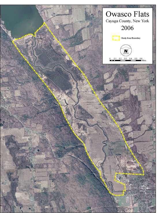
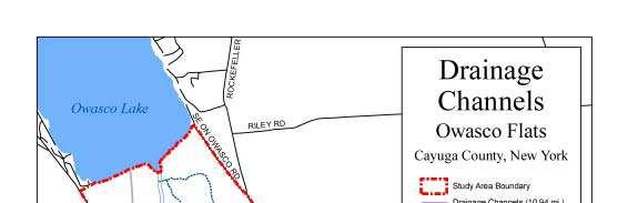
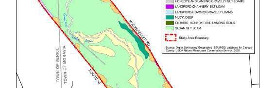
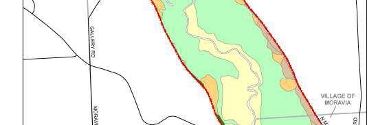
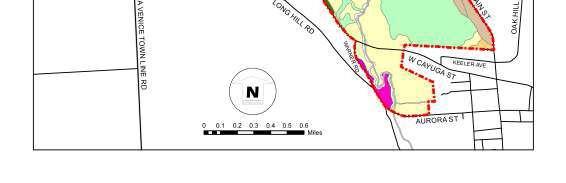
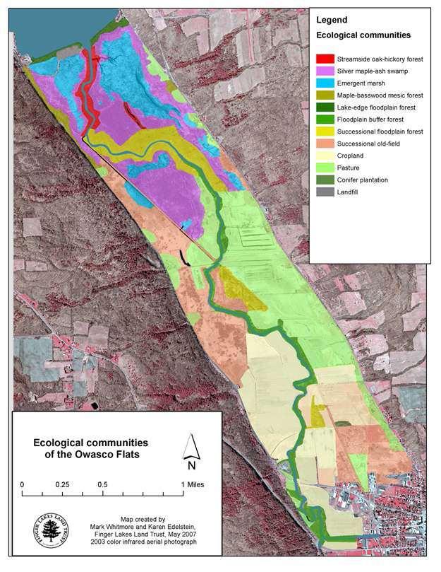
39 FINAL REPORT of the OWASCO FLATS Conservation Planning and Stakeholder Survey Project June 2007 By Mark Whitmore and the Finger Lakes Land Trust Funding for this project was provided by the Central New York Regional Planning and Development Board under a grant secured through the United States Department of Housing and Urban Development for the Finger Lakes Water Resources, Agriculture, and Open Lands Conservation Project.
40
41
42
43
44 Using GIS for Watershed Protection and Management The Watershed Protection and Management Process Monitoring 1. Aquatic Invasive Species 2. Citizen Monitoring Program (OWLA CCWQMA) 3. OWN 4. FIMS The Division of Water, Watershed Management Cycle, NYSDEC
45 New York Federation of Lake Association 2014 Conference, Celebrating Lake Stewardship Robert N. Brower, CEO November 15, 2013 Finger Lakes Research Conference, The Finger Lakes Institute at Hobart and William Smith
46 Using GIS for Watershed Protection and Management A Brief Description of GIS and GIT The Watershed Protection and Management Process and Stewardship Managing the Lake and Watershed with GIS/GIT A Range of Applications
Puakea, Hawaiÿi. Puakea, Hawaiÿi WATERSHED FEATURES
 Puakea, Hawaiÿi DAR Watershed Code: 85046 Puakea, Hawaiÿi WATERSHED FEATURES Puakea watershed occurs on the island of Hawaiÿi. The Hawaiian meaning of the name is white blossom. The area of the watershed
Keanahalululu Gulch, Hawaiÿi
 DAR Watershed Code: 85021 WATERSHED FEATURES Keanahalululu Gulch watershed occurs on the island of Hawaiÿi. The Hawaiian meaning of the name is unknown. The area of the watershed is 4.1 square mi (10.6
Presented by: Bryan Bloch GIS Specialist DNREC Division of Watershed Stewardship
 Presented by: Bryan Bloch GIS Specialist DNREC Division of Watershed Stewardship Bryan Hall, AICP Sussex County Circuit Rider Planner, Office of State Planning Coordination, OMB November 19, 2012 UD Sustainable
A Comprehensive Inventory of the Number of Modified Stream Channels in the State of Minnesota. Data, Information and Knowledge Management.
 A Comprehensive Inventory of the Number of Modified Stream Channels in the State of Minnesota Data, Information and Knowledge Management Glenn Skuta Environmental Analysis and Outcomes Division Minnesota
How Do Human Impacts and Geomorphological Responses Vary with Spatial Scale in the Streams and Rivers of the Illinois Basin?
 How Do Human Impacts and Geomorphological Responses Vary with Spatial Scale in the Streams and Rivers of the Illinois Basin? Bruce Rhoads Department of Geography University of Illinois at Urbana-Champaign
WELCOME Lake Wabukayne OPEN HOUSE
 WELCOME Lake Wabukayne Sediment Removal Project OPEN HOUSE We are here to: Update you, the community, on recent developments and activities at Lake Wabukayne Present the preferred alternative and receive
Application of an Enhanced, Fine-Scale SWAT Model to Target Land Management Practices for Maximizing Pollutant Reduction and Conservation Benefits
 Application of an Enhanced, Fine-Scale SWAT Model to Target Land Management Practices for Maximizing Pollutant Reduction and Conservation Benefits Amanda Flynn, Todd Redder, Joe DePinto, Derek Schlea Brian
Data Dictionary Hudson River Features: Estuary shoreline Flood scenario Emergency Services: Police stations Fire stations EMS
 Data Dictionary Hudson River Features: Estuary shoreline This data layer represents the border of the Hudson River in our study area. New York State Department of Environmental Conservation. 2009. Hudson
Wetlands and Riparian Mapping Framework Technical Meeting
 Wetlands and Riparian Mapping Framework Technical Meeting Meghan Burns Landscape Ecologist Linda Vance Senior Ecologist Why wetland and riparian mapping? Preliminary site assessment for the presence of
MARYLAND S LAND USE/LAND COVER MAP AND ASSOCIATED ANALYSIS
 MARYLAND S LAND USE/LAND COVER MAP AND ASSOCIATED ANALYSIS Maryland Department of Planning Daniel Baldwin Stephanie Martins November 19, 2012 http://www.planning.maryland.gov/ PURPOSE The primary purpose
Geospatial Data, Services, and Products. National Surveying, mapping and geospatial conference
 Geospatial Data, Services, and Products Federal Programs -- USDA NRCS National Surveying, mapping and geospatial conference March 15, 2016 NRCS Applications using Geosaptial Products & Services Field
North Wales PRP for Wissahickon Creek Nutrients
 North Wales PRP for Wissahickon Creek Nutrients July 14, 2017 Revised September 7, 2017 Revised August 9, 2018 Prepared for: North Wales Borough 300 School Street North Wales, PA 19454 Corporate Headquarters
Huron Creek Watershed 2005 Land Use Map
 Huron Creek Watershed 2005 Land Use Map Created By: Linda Kersten, 12/20/06 Created For: MTU Introduction to GIS Class (FW 5550) The Huron Creek Watershed Advisory Committee Michigan Technological University,
Spatial Data Availability Energizes Florida s Citizens
 NASCIO 2016 Recognition Awards Nomination Spatial Data Availability Energizes Florida s Citizens State of Florida Agency for State Technology & Department of Environmental Protection Category: ICT Innovations
Wailupe, Oÿahu. Wailupe, Oÿahu WATERSHED FEATURES
 DAR Watershed Code: 33005 WATERSHED FEATURES Wailupe watershed occurs on the island of Oÿahu. The Hawaiian meaning of the name is kite water. The area of the watershed is 3.4 square mi (8.8 square km),
Living in a Watershed
 Living in a Watershed Department of Ecosystem Science and Ma... http://ecosystems.psu.edu/youth/sftrc/lesson-plans/water/k-5/watershed Department of Ecosystem Science and Management Youth Living in a Watershed
Geospatial SDI Portal for effective Governance of Pune METROPOLIS region
 Geospatial SDI Portal for effective Governance of Pune METROPOLIS region Mr. Praveen Gautam Senior Manager 19 th January 2018 PMRDA Overview Provide a Spatial Framework for the entire region with various
Wetland Mapping & Functional Assessment Canadian River Watershed New Mexico. Association of State Wetland Managers
 Wetland Mapping & Functional Assessment Canadian River Watershed New Mexico Association of State Wetland Managers November, 2012 Approach for this project based on: EPA 2006 Document: Application of Elements
Effects of input DEM data spatial resolution on Upstream Flood modeling result A case study in Willamette river downtown Portland
 Effects of input DEM data spatial resolution on Upstream Flood modeling result A case study in Willamette river downtown Portland By Hue Duong GEOG 593 Fall 2015 Digital Terrain Analysis Photo: Anh Duc
Techniques for Science Teachers: Using GIS in Science Classrooms.
 Techniques for Science Teachers: Using GIS in Science Classrooms. After ESRI, 2008 GIS A Geographic Information System A collection of computer hardware, software, and geographic data used together for
Wailua, Maui WATERSHED FEATURES
 Wailua, Maui DAR Watershed Code: 65007 Wailua, Maui WATERSHED FEATURES Wailua watershed occurs on the island of Maui. The Hawaiian meaning of the name is two waters. The area of the watershed is 1.9 square
Land Use Methods & Metrics Development Outcome
 Quarterly Progress Meeting November 15, 2018 Land Use Methods & Metrics Development Outcome Peter Claggett, USGS LUWG Coordinator Through the Chesapeake Bay Watershed Agreement, the Chesapeake Bay Program
USGS Hydrography Overview. May 9, 2018
 + 1 USGS Hydrography Overview May 9, 2018 + 2 The National Geospatial Program Provides the geospatial baseline of the Nation s topography, natural landscape and built environment through The National Map,
DEPARTMENT OF GEOLOGY AND MINERAL INDUSTRIES WAYS & MEANS SUBCOMMITTEE ON NATURAL RESOURCES MARCH 2, 2017
 DEPARTMENT OF GEOLOGY AND MINERAL INDUSTRIES WAYS & MEANS SUBCOMMITTEE ON NATURAL RESOURCES MARCH 2, 2017 1 ABOUT DOGAMI AGENCY MISSION, VISION & GOALS 2 Lidar image of a stream network along the Umpqua
ESRI NONPROFIT/CONSERVATION GRANTS PROGRAM STATUS REPORT JANUARY 2010
 ESRI NONPROFIT/CONSERVATION GRANTS PROGRAM STATUS REPORT JANUARY 2010 Grantee ESRI Client Number 150983 FARMINGTON RIVER WATERSHED ASSOCIATION 749 Hopmeadow Street, Simsbury, Connecticut 06070 Contact:
Defining the Limit of Regulated Areas. C.1 Defining the River or Stream Flood Hazard 138. C.2 Defining the River or Stream Erosion Hazard 139
 C.1 Defining the River or Stream Flood Hazard 138 C.2 Defining the River or Stream Erosion Hazard 139 C.3 Defining Watercourses 141 C.4 Defining the Lake Ontario Shoreline Flood, Erosion and Dynamic Beach
The Road to Data in Baltimore
 Creating a parcel level database from high resolution imagery By Austin Troy and Weiqi Zhou University of Vermont, Rubenstein School of Natural Resources State and local planning agencies are increasingly
Learning Objectives: I can identify and interpret river flows and directions.
 Learning Objectives: I can identify and interpret river flows and directions. Bellringer Review: Check for Understanding Questions: 1 2 What Are The Key Parts Of A River s Anatomy? In your data notebooks
New Land Cover & Land Use Data for the Chesapeake Bay Watershed
 New Land Cover & Land Use Data for the Chesapeake Bay Watershed Why? The Chesapeake Bay Program (CBP) partnership is in the process of improving and refining the Phase 6 suite of models used to inform
STUDY GUIDE FOR CONTENT MASTERY. Surface Water Movement
 Surface Water SECTION 9.1 Surface Water Movement In your textbook, read about surface water and the way in which it moves sediment. Complete each statement. 1. An excessive amount of water flowing downslope
Your web browser (Safari 7) is out of date. For more security, comfort and the best experience on this site: Update your browser Ignore
 is out of date. For more security, comfort and the best experience on this site: Update your browser Ignore") Your web browser (Safari 7) is out of date. For more security, comfort and the best experience on this site: Update your browser Ignore GIS ( GEO GRAPHIC INFO RMATIO N SYSTEM) geospatial information system
Your web browser (Safari 7) is out of date. For more security, comfort and the best experience on this site: Update your browser Ignore GIS ( GEO GRAPHIC INFO RMATIO N SYSTEM) geospatial information system
2011 Land Use/Land Cover Delineation. Meghan Jenkins, GIS Analyst, GISP Jennifer Kinzer, GIS Coordinator, GISP
 2011 Land Use/Land Cover Delineation Meghan Jenkins, GIS Analyst, GISP Jennifer Kinzer, GIS Coordinator, GISP History O Key Points O Based on Anderson s Land Use and Land Cover Classification System O
South Florida Coastal Storm Surge and Mapping Study
 South Florida Coastal Storm Surge and Mapping Study Presented by Christopher Bender, Ph.D., P.E., D.CE June 2, 2015 Presentation Overview FEMA risk studies outline Overview South Florida surge study Work
Semester Project Final Report. Logan River Flood Plain Analysis Using ArcGIS, HEC-GeoRAS, and HEC-RAS
 Semester Project Final Report Logan River Flood Plain Analysis Using ArcGIS, HEC-GeoRAS, and HEC-RAS Kedric Curtis, Josh Hogge, Jordan Jarrett, Jared Justensen May 6, 2016 CEE 6190 GIS for Civil Engineers
Using Big Interagency Databases to Identify Climate Refugia for Idaho s Species of Concern
 Using Big Interagency Databases to Identify Climate Refugia for Idaho s Species of Concern What is a Climate Refugia? habitat that supports a locally reproducing population [or key life history stage]
NAVAJO NATION PROFILE
 NAVAJO NATION PROFILE Largest land based area and federally recognized tribe in the United States Over 27,000 square miles (or 17.2 million acres with a population of over 300,000 people. Covers Arizona,
Catastrophic Events Impact on Ecosystems
 Catastrophic Events Impact on Ecosystems Hurricanes Hurricanes An intense, rotating oceanic weather system with sustained winds of at least 74 mph and a welldefined eye Conditions for formation: Warm water
STEREO ANALYST FOR ERDAS IMAGINE Stereo Feature Collection for the GIS Professional
 STEREO ANALYST FOR ERDAS IMAGINE Stereo Feature Collection for the GIS Professional STEREO ANALYST FOR ERDAS IMAGINE Has Your GIS Gone Flat? Hexagon Geospatial takes three-dimensional geographic imaging
Pierce Cedar Creek Institute GIS Development Final Report. Grand Valley State University
 Pierce Cedar Creek Institute GIS Development Final Report Grand Valley State University Major Goals of Project The two primary goals of the project were to provide Matt VanPortfliet, GVSU student, the
Natural Shoreline Landscapes on Michigan Inland Lakes
 Natural Shoreline Landscapes on Michigan Inland Lakes Excerpts from Chapters 2 and 3 Photo Photo by Jane by Jane Herbert Herbert Did you know? Twenty-four species of amphibians, 25 species of reptiles,
Delineation of Watersheds
 Delineation of Watersheds Adirondack Park, New York by Introduction Problem Watershed boundaries are increasingly being used in land and water management, separating the direction of water flow such that
Assessment of Lake Forest Lake Sediment Trapping Efficiency and Capacity. Marlon R. Cook Groundwater Assessment Program Geological Survey of Alabama
 Assessment of Lake Forest Lake Sediment Trapping Efficiency and Capacity Marlon R. Cook Groundwater Assessment Program Geological Survey of Alabama Impacts of the Lake at Lake Forest on the connectivity
Chesapeake Bay Program s New Land Cover Map (and some other neat stuff)
") Chesapeake Bay Program s New Land Cover Map (and some other neat stuff) Cassandra Pallai Geospatial Project Manager Chesapeake Conservancy December 6, 2016 Potomac Watershed Partnership Chesapeake Conservancy
Chesapeake Bay Program s New Land Cover Map (and some other neat stuff) Cassandra Pallai Geospatial Project Manager Chesapeake Conservancy December 6, 2016 Potomac Watershed Partnership Chesapeake Conservancy
RANGE AND ANIMAL SCIENCES AND RESOURCES MANAGEMENT - Vol. II - Catchment Management A Framework for Managing Rangelands - Hugh Milner
 CATCHMENT MANAGEMENT A FRAMEWORK FOR MANAGING RANGELANDS Hugh Milner International Water Management Consultant, Australia Keywords: Rangeland management; catchments and watersheds; catchment management
Opportunities to Improve Ecological Functions of Floodplains and Reduce Flood Risk along Major Rivers in the Puget Sound Basin
 Opportunities to Improve Ecological Functions of Floodplains and Reduce Flood Risk along Major Rivers in the Puget Sound Basin Christopher Konrad, US Geological Survey Tim Beechie, NOAA Fisheries Managing
Water Atlas Overview. Myakka River Management Coordinating Council June 22, 2012 Englewood, Florida
 Water Atlas Overview Myakka River Management Coordinating Council June 22, 2012 Englewood, Florida What is the Water Atlas? A data warehouse A set of interactive maps A collection of tools for viewing/analyzing
Chapter 3 - White Oak River Subbasin Includes Bogue Sound and the Newport River
 Chapter 3 - White Oak River Subbasin 03-05-03 Includes Bogue Sound and the Newport River 3.1 Water Quality Overview Subbasin 03-05-03 at a Glance Land and Water Area (sq. mi.) Total area: 228 Land area:
United States Department of the Interior NATIONAL PARK SERVICE Northeast Region
 United States Department of the Interior NATIONAL PARK SERVICE Northeast Region June 17, 2017 REQUEST FOR STATEMENTS OF INTEREST and QUALIFICATIONS Project Title: ASSESSMENT OF NATURAL RESOURCE CONDITION
Chesapeake Bay Remote Sensing Pilot Executive Briefing
 Chesapeake Bay Remote Sensing Pilot Executive Briefing Introduction In his Executive Order 13506 in May 2009, President Obama stated The Chesapeake Bay is a national treasure constituting the largest estuary
Chapter 4 French Broad River Subbasin Including the: French Broad River, Little Ivy Creek (River), Ivy Creek, California Creek and Bull Creek
, Ivy Creek, California Creek and Bull Creek") Chapter 4 French Broad River Subbasin 04-03-04 Including the: French Broad River, Little Ivy Creek (River), Ivy Creek, California Creek and Bull Creek 4.1 Subbasin Overview Subbasin 04-03-04 at a Glance
Chapter 4 French Broad River Subbasin 04-03-04 Including the: French Broad River, Little Ivy Creek (River), Ivy Creek, California Creek and Bull Creek 4.1 Subbasin Overview Subbasin 04-03-04 at a Glance
Total Maximum Daily Load (TMDL) South Branch Codorus Creek Watershed York County
 South Branch Codorus Creek Watershed York County") Total Maximum Daily Load (TMDL) South Branch Codorus Creek Watershed York County Pennsylvania Department of Environmental Protection Central Office Office of Water Management July 9, 2003 Table of Contents
Total Maximum Daily Load (TMDL) South Branch Codorus Creek Watershed York County Pennsylvania Department of Environmental Protection Central Office Office of Water Management July 9, 2003 Table of Contents
APPENDIX PHASE 1 GREEN INFRASTRUCTURE FRAMEWORK
 APPENDIX PHASE 1 GREEN INFRASTRUCTURE FRAMEWORK KANSAS MISSOURI CONTENTS A DATA WISHLIST 4 B PRECEDENTS 7 C WORKSHOP MATERIALS 13 D ANALYSIS PROCESS 124 E ATLAS & PLAYBOOK DETAILS 156 F POLICY ANALYSIS
GIS Monroe Geographic Information System March 14, 2018
 GIS Monroe Geographic Information System March 14, 2018 Goals Maintain Enterprise/County-wide geo-database Increase spatial accuracy of data Build and acquire more data layers Increase use of GIS; as another
NATIONAL HYDROGRAPHY DATASET (NHD) UPDATE PROJECT FOR US FOREST SERVICE REGION 3
 UPDATE PROJECT FOR US FOREST SERVICE REGION 3") NATIONAL HYDROGRAPHY DATASET (NHD) UPDATE PROJECT FOR US FOREST SERVICE REGION 3 Allison Moncada California State University, Northridge February 2018 July 2018 Advisor: Joel Osuna Center for Geospatial
NATIONAL HYDROGRAPHY DATASET (NHD) UPDATE PROJECT FOR US FOREST SERVICE REGION 3 Allison Moncada California State University, Northridge February 2018 July 2018 Advisor: Joel Osuna Center for Geospatial
MISSOURI LiDAR Stakeholders Meeting
 MISSOURI LiDAR Stakeholders Meeting East-West Gateway June 18, 2010 Tim Haithcoat Missouri GIO Enhanced Elevation Data What s different about it? Business requirements are changing.fast New data collection
ROAD SEDIMENT ASSESSMENT & MODELING: KOOTENAI-FISHER TMDL PLANNING AREA ROAD GIS LAYERS & SUMMARY STATISTICS
 ROAD SEDIMENT ASSESSMENT & MODELING: KOOTENAI-FISHER TMDL PLANNING AREA ROAD GIS LAYERS & SUMMARY STATISTICS Prepared by: ATKINS Water Resources Group 820 North Montana Avenue Helena, MT 59601 November
LONG POINT REGION CONSERVATION AUTHORITY
 LONG POINT REGION CONSERVATION AUTHORITY Reference Manual DETERMINATION OF REGULATION LIMITS L o n g P o i n t R e g i o n C o n s e r v a t i o n A u t h o r i t y D e t e r m i n a t i o n o f R e g
Highland Lake Bathymetric Survey
 Highland Lake Bathymetric Survey Final Report, Prepared For: The Town of Highland Lake 612 Lakeshore Drive Oneonta, AL 35121 Prepared By: Tetra Tech 2110 Powers Ferry Road SE Suite 202 Atlanta, GA 30339
Sediment and nutrient transport and storage along the urban stream corridor
 Sediment and nutrient transport and storage along the urban stream corridor Greg Noe, Cliff Hupp, Ed Schenk, Jackie Batson, Nancy Rybicki, Allen Gellis What is the role of floodplains everywhere? Noe 2013,
Environment and Natural Resources Trust Fund 2010 Request for Proposals (RFP)
") LCCMR ID: 141-E2 Project Title: Environment and Natural Resources Trust Fund 2010 Request for Proposals (RFP) Monitoring and Modeling Minnesota Landscapes and Ecosystem Services LCCMR 2010 Funding Priority:
LCCMR ID: 141-E2 Project Title: Environment and Natural Resources Trust Fund 2010 Request for Proposals (RFP) Monitoring and Modeling Minnesota Landscapes and Ecosystem Services LCCMR 2010 Funding Priority:
Ms. A. Mormando's Class *
 8 th Grade Science Essential Standard: 8.E.1.1 Explain the structure of the hydrosphere including: Water distribution on Earth; Local river basin and water availability Stream - A stream is a body of water
Rabbit River Turbidity Total Maximum Daily Load Report (Impaired River Reach AUID )
") Rabbit River Turbidity Total Maximum Daily Load Report (Impaired River Reach AUID 09020101-502) Submitted to: U.S. Environmental Protection Agency Region 5, Chicago, Illinois Submitted by: June 2010 Table
Rabbit River Turbidity Total Maximum Daily Load Report (Impaired River Reach AUID 09020101-502) Submitted to: U.S. Environmental Protection Agency Region 5, Chicago, Illinois Submitted by: June 2010 Table
How Do Geology and Physical Streambed Characteristics Affect Water Quality?
 Teacher s Guide How Do Geology and Physical Streambed Characteristics Affect Water Quality? Lesson Description In this lesson, the students research a dynamic, vertical dimension of a watershed - the geological
Sediment Deposition LET THE RIVER RUN T E A C H E R. Activity Overview. Activity at a Glance. Time Required. Level of Complexity.
 Activity at a Glance Grade: 6 9 Subject: Science Category: Physical Science, Earth Science Topic: Deposition, River Systems Time Required Two 45-minute periods Level of Complexity Medium Materials* TI-73
Watershed Analysis Using Remote Sensing and GPS
 25 th Annual Louisiana Remote Sensing and GIS Workshop Baton Rouge, 2009 Watershed Analysis Using Remote Sensing and GPS Warren L. Kron, Jr. Quang Tran Baton Rouge City-Parish Planning Commission José
Evaluating Wildlife Habitats
 Lesson C5 4 Evaluating Wildlife Habitats Unit C. Animal Wildlife Management Problem Area 5. Game Animals Management Lesson 4. Evaluating Wildlife Habitats New Mexico Content Standard: Pathway Strand: Natural
Fig 1. Steps in the EcoValue Project
 Assessing the Social and Economic Value of Ecosystem Services in the Northern Forest Region: A Geographic Information System (GIS) Approach to Landscape Valuation Principal Investigator(s): Dr. Matthew
Ecology of Cyanobacteria. Lisa B. Cleckner, Director September 30, 2017
 Ecology of Cyanobacteria Lisa B. Cleckner, Director cleckner@hws.edu September 30, 2017 Finger Lakes Institute @ HWS Research Education Outreach Economic Development Halfman 2016 http://www.fingerlakessustainablefarming.org/
Web (Java, ArcGIS Server [WebADF, flex, silverlight]) Mobile (ArcGIS Mobile, ArcPad, Windows Mobile) Deskt
![Web (Java, ArcGIS Server [WebADF, flex, silverlight]) Mobile (ArcGIS Mobile, ArcPad, Windows Mobile) Deskt](/thumbs/96/129284052.jpg "Web (Java, ArcGIS Server [WebADF, flex, silverlight]) Mobile (ArcGIS Mobile, ArcPad, Windows Mobile) Deskt") GIS Services company in Lincoln, NE Custom GIS database design and build (for local, county, state and private corporations) Custom (ESRI and non-esri) application design and build in Java, C++, C#,.Net
GIS Services company in Lincoln, NE Custom GIS database design and build (for local, county, state and private corporations) Custom (ESRI and non-esri) application design and build in Java, C++, C#,.Net
Elm Creek Watershed Management Commission 2016 Treasurer's Report
 Elm Creek Watershed Management Commission Treasurer's Report Budget Dec Jan 2017 Budget YTD EXPENSES Administrative 90,000 7,638.16 8,201.65 84,997.87 Watershed-wide TMDL 24,406 246.53 126.20 1,432.35
National Hydrography Dataset (NHD) Update Project for US Forest Service Region 3
 Update Project for US Forest Service Region 3") National Hydrography Dataset (NHD) Update Project for US Forest Service Region 3 Allison Moncada California State University, Northridge February 2017 July 2017 Advisor: Joel Osuna Center for Geographical
National Hydrography Dataset (NHD) Update Project for US Forest Service Region 3 Allison Moncada California State University, Northridge February 2017 July 2017 Advisor: Joel Osuna Center for Geographical
Roger Andy Gaines, Research Civil Engineer, PhD, P.E.
 Roger Andy Gaines, Research Civil Engineer, PhD, P.E. Research Civil Engineer/Regional Technical Specialist Memphis District August 24, 2010 Objectives Where we have been (recap of situation and what s
3.11 Floodplains Existing Conditions
 Other stormwater control practices may be needed to mitigate water quality impacts. In addition to detention facilities, other practices such as vegetated basins/buffers, infiltration basins, and bioswales
Regional GIS Initiatives Geospatial Technology Center
 Regional GIS Initiatives Geospatial Technology Center Mr. Bobby Lear GIS Coordinator St. James Parish & Dr. Balaji Ramachandran Contractors Educational Trust Fund Endowed Professor Geomatics Program, Department
Virginia Shoreline Mapping Tools
 Virginia Shoreline Mapping Tools December 15, 2017 Karen Duhring Center for Coastal Resources Management Virginia Institute of Marine Science College of William & Mary Virginia Shoreline Mapping Tools
SEAGRASS COVERAGE TRENDS IN THE INDIAN RIVER LAGOON SYSTEM
 Biological Sciences SEAGRASS COVERAGE TRENDS IN THE INDIAN RIVER LAGOON SYSTEM R. W. VIRNSTEIN *,J.S.STEWARD, AND L. J. MORRIS St. Johns River Water Management District, Palatka, FL 32178 ABSTRACT: We
Urban Tree Canopy Assessment Purcellville, Virginia
 GLOBAL ECOSYSTEM CENTER www.systemecology.org Urban Tree Canopy Assessment Purcellville, Virginia Table of Contents 1. Project Background 2. Project Goal 3. Assessment Procedure 4. Economic Benefits 5.
What are the issues?
 Water Quality along Lake Huron What are the issues? Lake Huron Water Quality Algal fouling Irregular, less frequent, less widespread, but some significant local events Influences Tributaries contribute;
Compact guides GISCO. Geographic information system of the Commission
 Compact guides GISCO Geographic information system of the Commission What is GISCO? GISCO, the Geographic Information System of the COmmission, is a permanent service of Eurostat that fulfils the requirements
Home About Us Articles Press Releases Image Gallery Contact Us Media Kit Free Subscription 10/5/2006 5:56:35 PM
 Home About Us Articles Press Releases Image Gallery Contact Us Media Kit Free Subscription 10/5/2006 5:56:35 PM Industry Resources Industry Directory NASA Links Missions/Launches Calendar Human development
The Refugia Concept: Using Watershed Analysis to Prioritize Salmonid Habitat for Conservation and Restoration
 The Refugia Concept: Using Watershed Analysis to Prioritize Salmonid Habitat for Conservation and Restoration Christopher May Battelle & UW Cumulative Impacts of Urbanization Landscape Alterations Loss
Which map shows the stream drainage pattern that most likely formed on the surface of this volcano? A) B)
 B)") 1. When snow cover on the land melts, the water will most likely become surface runoff if the land surface is A) frozen B) porous C) grass covered D) unconsolidated gravel Base your answers to questions
1. When snow cover on the land melts, the water will most likely become surface runoff if the land surface is A) frozen B) porous C) grass covered D) unconsolidated gravel Base your answers to questions
Data Collection and GIS Applications
 Data Collection and GIS Applications Governor s s Conference on the Management of the Illinois River System Jeff Jack of all Trades Boeckler, IDNR Introduction Collecting available GIS data sets Creating
Understanding the effects of roads in upland settings on hydrology, geomorphology and water quality
 Understanding the effects of roads in upland settings on hydrology, geomorphology and water quality Beverley Wemple Department of Geography and Rubenstein School of Environment & Natural Resources The
PPT Slide. Slide 1 of 32. Notes:
 Slide 1 of 32 This presentaion will describe the background of establishing an agricultural district in Westchester County and how GIS was used to map the district. file:///volumes/web/www/ce/conferences/gis%20present/testfarm/sld001.htm[4/6/11
Gina Hunt Chesapeake Bay Program Fish Habitat Coordinator
 Gina Hunt Chesapeake Bay Program Fish Habitat Coordinator Regional Fish Habitat Assessment User Needs A guiding principal for the assessment framework is that it should support planning and management
INTERNATIONAL JOURNAL OF PURE AND APPLIED RESEARCH IN ENGINEERING AND TECHNOLOGY
 INTERNATIONAL JOURNAL OF PURE AND APPLIED RESEARCH IN ENGINEERING AND TECHNOLOGY A PATH FOR HORIZING YOUR INNOVATIVE WORK SPECIAL ISSUE FOR NATIONAL LEVEL CONFERENCE "SUSTAINABLE TECHNOLOGIES IN CIVIL
Chapter 6. Fundamentals of GIS-Based Data Analysis for Decision Support. Table 6.1. Spatial Data Transformations by Geospatial Data Types
 Chapter 6 Fundamentals of GIS-Based Data Analysis for Decision Support FROM: Points Lines Polygons Fields Table 6.1. Spatial Data Transformations by Geospatial Data Types TO: Points Lines Polygons Fields
Megan Durden, North Carolina State Archives Butch Lazorchak, Library of Congress Mark Myers, Kentucky State Archives Best Practices Exchange, Helena,
 GIS are from Mars, Archivists are from Venus: Linking State Government Geospatial Professionals and their Cultural l Heritage Counterparts Megan Durden, North Carolina State Archives Butch Lazorchak, Library
GIS and Coastal Nutrients Luke Cole
 GIS and Coastal Nutrients Luke Cole Human population density has been widely utilized as a valid predictor of terrestrial nitrogen loads into marine systems. As 50% of the world s population lives within
Keaÿahala, Oÿahu. Keaÿahala, Oÿahu WATERSHED FEATURES
 DAR Watershed Code: 32009 WATERSHED FEATURES Keaÿahala watershed occurs on the island of Oÿahu. The Hawaiian meaning of the name is the pandanas root. The area of the watershed is 1.6 square mi (4.2 square
Flood Hazard Zone Modeling for Regulation Development
 Flood Hazard Zone Modeling for Regulation Development By Greg Lang and Jared Erickson Pierce County GIS June 2003 Abstract The desire to blend current digital information with government permitting procedures,
low turbidity high turbidity
 What is Turbidity? Turbidity refers to how clear the water is. The greater the amount of total suspended solids (TSS) in the water, the murkier it appears and the higher the measured turbidity. Excessive
Graduate Courses Meteorology / Atmospheric Science UNC Charlotte
 Graduate Courses Meteorology / Atmospheric Science UNC Charlotte In order to inform prospective M.S. Earth Science students as to what graduate-level courses are offered across the broad disciplines of
Overview of fluvial and geotechnical processes for TMDL assessment
 Overview of fluvial and geotechnical processes for TMDL assessment Christian F Lenhart, Assistant Prof, MSU Research Assoc., U of M Biosystems Engineering Fluvial processes in a glaciated landscape Martin
The Emerging Role of Enterprise GIS in State Forest Agencies
 The Emerging Role of Enterprise GIS in State Forest Agencies Geographic Information System (GIS) A geographic information system (GIS) is a computer software system designed to capture, store, manipulate,
Urbanization factors in the Gilleland Creek watershed, Travis County, Texas. Michael Kanarek GEO386G Final Project Dec. 2, 2011
 Urbanization factors in the Gilleland Creek watershed, Travis County, Texas Michael Kanarek GEO386G Final Project Dec. 2, 2011 1 Introduction The watershed of Gilleland Creek, which flows through eastern
Illinois State Water Survey Division
 Illinois State Water Survey Division SURFACE WATER SECTION SWS Miscellaneous Publication 108 SEDIMENT YIELD AND ACCUMULATION IN THE LOWER CACHE RIVER by Misganaw Demissie Champaign, Illinois June 1989
Lesson Plan 3 Land Cover Changes Over Time. An Introduction to Land Cover Changes over Time
 An Introduction to Land Cover Changes over Time This lesson plan builds on the lesson plan on Understanding Land Use and Land Cover Using Google Earth. Please refer to it in terms of definitions on land
Designing a Dam for Blockhouse Ranch. Haley Born
 Designing a Dam for Blockhouse Ranch Haley Born CE 394K GIS in Water Resources Term Paper Fall 2011 Table of Contents Introduction... 1 Data Sources... 2 Precipitation Data... 2 Elevation Data... 3 Geographic