The Laxford Shear Zone: an end-archaean terrane boundary?
|
|
|
- Benedict Floyd
- 5 years ago
- Views:
Transcription
1 The Laxford Shear Zone: an end-archaean terrane boundary? K M Goodenough 1,* ; R G Park 2 ; M Krabbendam 1 ; J S Myers 3 ; J Wheeler 4 ; S C Loughlin 1 ; Q G Crowley 5,10 ; C R L Friend 6 ; A Beach 7 ; P D Kinny 8 and R H Graham 9. 1: British Geological Survey, West Mains Road, Edinburgh EH9 3LA, UK. (* Corresponding author: kmgo@bgs.ac.uk) 2: 12 Provost Ferguson Drive, Tain, Ross-shire IV19 1RE, UK 3: 77 Falls Road, Lesmurdie, WA 6076, Australia 4: Department of Earth and Ocean Sciences, Liverpool University, Liverpool L69 3GP, UK 5: NERC Isotope Geosciences Laboratory, Keyworth, Nottingham, NG12 5GG, UK 6: 45, Stanway Road, Risinghurst, Headington, Oxford, OX3 8HU 7: Exploration Outcomes, 1 Huntly Gardens, Glasgow, G12 9AS 8: Department of Applied Geology, Curtin University of Technology, GPO Box U1987 Perth 6845, Western Australia 9: Hess, Level 9, Adelphi Building, London WC2N 6AG, UK 10: Department of Geology, Trinity College, Dublin 2, Ireland Text 7,815 words; References 1,700 words; 7 figures; 1 table Abbreviated title: The Laxford Shear Zone 1
2 Abstract The Lewisian Gneiss Complex of north-western Scotland consists of Archaean gneisses, variably reworked during the Proterozoic. It can be divided into three districts a central granulite-facies district between districts of amphibolite-facies gneiss to the north and south. Recent work has interpreted these districts in terms of separate terranes, initiating a controversy that has implications for how Precambrian rocks are understood worldwide. The northern district of the Lewisian Gneiss Complex (the Rhiconich terrane) is separated from the central district (the Assynt terrane) by a broad ductile shear zone known as the Laxford Shear Zone. This paper reviews the geology of the Laxford Shear Zone, clarifying field relationships and discussing other evidence, to consider whether or not it does indeed represent a terrane boundary. A detailed review of field, geochemical and geochronological evidence supports the recognition of the separate Assynt and Rhiconich terranes. Mafic dykes (the Scourie Dyke Swarm) and granitoids, of Palaeoproterozoic age, occur on both sides of the Laxford Shear Zone and thus the terranes were most probably juxtaposed during the late Archaean to early Palaeoproterozoic Inverian event. Subsequently, the less-competent, more-hydrous amphibolite-facies gneisses of the Rhiconich terrane were affected by later Palaeoproterozoic (Laxfordian) deformation and partial melting, to a greater extent than the more-competent granulite-facies gneisses of the Assynt terrane. [end of abstract] 2
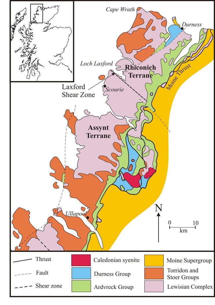
3 The Lewisian Gneiss Complex of north-western Scotland is one of the world s most intensively studied regions of high-grade Precambrian gneisses, yet it continues to provide fruitful ground for new research. It crops out on the islands of the Outer Hebrides and also in a 140 km-long strip along the north-west coast of the Scottish mainland, where it forms part of the foreland to the Caledonian orogen (Figure 1). The main outcrop is limited to the east by the Moine Thrust, although inliers of Lewisianoid gneiss occur to the east of this major structure. The Lewisian gneisses form part of a now-disrupted Precambrian region in the North Atlantic, which also includes basement rocks in North America, Greenland and Scandinavia. The essential elements of the Lewisian Gneiss Complex were identified a century ago by the authors of the classic Geological Survey Memoir on the Northwest Highlands (Peach et al., 1907). They recognised that the complex consists largely of metamorphosed plutonic igneous rocks, with relatively minor metasedimentary and metavolcanic units, cut by a variety of less-deformed igneous intrusions. They also divided the mainland Lewisian into three districts, northern, central and southern; the central district consisted largely of pyroxene-bearing gneiss (now recognised as granulite facies), whereas more strongly deformed hornblende- and biotite-bearing gneisses (amphibolite facies) cropped out to the north and south. The main events within the Lewisian Gneiss Complex were later identified by Sutton and Watson (1951), who recognised two major episodes of metamorphism and deformation, the Scourian and Laxfordian events, temporally separated by intrusion of an extensive dyke swarm known as the Scourie Dyke Swarm. A third, amphibolite-facies event, younger than the Scourian but pre-dating the Scourie Dykes, was recognised by Evans (1965) and termed the Inverian. The Scourian event was later renamed Badcallian (Park, 1970) and more tightly defined as a period of early granulite-facies metamorphism, which has to date only been recognised in the central district of the Lewisian Gneiss Complex. Over the last hundred years, the Lewisian Gneiss Complex has provided a natural laboratory for studies into many aspects of basement geology (Park et al. 2002; Wheeler et al. this volume). Major crustal-scale shear zones within the Lewisian gneisses have been studied in detail, and provide large-scale examples of the type of 3
4 shear zones described and analysed by the classic work of Ramsay and Graham (1970). Isotopic dating techniques were first harnessed for research into the history of the complex by Giletti et al. (1961) and have continued to provide crucial information as techniques and the application of these techniques to high-grade metamorphic terranes have been refined (see summary in Kinny et al., 2005). Most recently, geochronological data have been used to identify crustal blocks with different histories within the Lewisian Gneiss Complex, and it has been proposed that these represent separate terranes that were assembled along major shear zones (Friend and Kinny, 2001; Kinny et al., 2005). The details of this model remain rather controversial, and a simpler version in which two main terranes collided but were then divided into blocks by strike-slip movement has also been proposed (Park, 2005). Overall, though, the idea that the Lewisian Gneiss Complex does not represent a contiguous block of Archaean crust is becoming more widely accepted. It is clear that the terrane model can usefully be tested by detailed investigations of the terranebounding shear zones (Mason and Brewer, 2005). One of the strongest candidates for a terrane-bounding shear zone is the Laxford Shear Zone, which separates the amphibolite-facies gneisses of the northern district from the granulite-facies gneisses of the central district. Following Coward and Park (1987), the Laxford Shear Zone is here defined as the broad (~ 8 km) zone of Inverian and Laxfordian ductile shear that extends along the southern shore of Loch Laxford and continues along the northern side of Ben Stack (Figures 2a, b). During the Continental Tectonics and Mountain Building conference in Ullapool in May 2007, the authors of this paper engaged in two days of vigorous scientific discussion about the age and type of movements along that shear zone. The conclusions and further questions from that debate are presented here. This paper concentrates on reviewing previous work, clarifying the field relationships, and describing a consensus that has been reached by all the authors on the nature of the Laxford Shear Zone. Many disparate views on other aspects of the Lewisian exist within the author team, and these cannot all be addressed here. 4
5 Previous work on the Laxford Shear Zone The Lewisian gneisses of the Laxford area were first mapped by the Geological Survey towards the end of the nineteenth century (Peach et al., 1892) and described in the North-west Highlands Memoir (Peach et al., 1907). The surveyors recognised that Loch Laxford lay roughly along a zone that separated biotite- and hornblende-bearing gneisses of the northern district from pyroxene-bearing gneisses of the central district of the Lewisian Gneiss Complex. They described the rocks of the northern district as containing mafic layers that could be deformed dykes of the Scourie type, and abundant granites and pegmatites that cross-cut all the other rock-types. They also noted it is probable that all the granite dykes were not intruded at the same time. In the Loch Laxford area, they identified three WNW-ESE-trending belts in the Lewisian gneisses: 1) A north-eastern belt in which hornblende- and biotite-bearing gneisses are cut by intrusions of granite and pegmatite that probably exceed in bulk the gneisses themselves. 2) A middle belt of hornblende- and biotite-bearing gneisses cut by mafic dykes, with abundant folds and shear zones. This belt was essentially what we would now describe as the Laxford Shear Zone. 3) A south-western belt of pyroxene-bearing gneisses in which the gently dipping gneissosity is cross-cut by undeformed mafic dykes (the Scourie Dyke Swarm). The next major study of the area was that of Sutton and Watson (1951). They considered that three major episodes could be recognised in the history of the gneisses around Loch Laxford: an early, Scourian metamorphic event during which granulite-facies pyroxene-bearing gneisses were formed; a period of intrusion of dolerite dykes (the Scourie Dykes); and a second, Laxfordian metamorphic event in which the gneisses of the northern district were retrogressed to form hornblende- and biotite-bearing gneisses (amphibolite facies metamorphism). Sutton and Watson believed that the gneisses of the central and northern districts shared the same early history, and were only distinguished by the later effects of the Laxfordian event. They divided the Loch Laxford area into five zones (Figure 2b) and suggested that the 5
6 variations across the zones were controlled by an episode of deformation, producing structures with a north-west to south-east trend and a front of migmatisation. The five zones are (from SW to NE): 1) The Scourie zone, in which Laxfordian movement and metamorphism have only had a local effect on the Scourian complex. This equates to the southwestern belt of the 1907 Memoir. Sutton and Watson (1962) suggested that the north-eastern boundary of this zone should be taken as the local Laxfordian front, and thus that all the gneisses to the north had undergone retrogression and metasomatism during the Laxfordian event. 2) The Claisfearn zone, consisting of flaggy gneisses with a steep southwestward dip, and numerous shear-belts. 3) The Foindle zone, also with steep south-westward dips, and incorporating a thick band of mafic rocks (Figure 2a). Units of brown-weathering, schistose biotite-bearing gneisses were recognised and were considered to have formed through metasomatism of the mafic rocks. Shear belts were described as being entirely confined to the basic bodies over much of this zone, and granite and pegmatite veins were considered to dwindle southwards across the zone. The Claisfearn and Foindle zones together represent the middle belt of the 1907 Memoir. 4) The Badnabay zone, in which a large number of concordant sheets of granitegneiss appear and there are no shear-belts ; the main foliation in this area was considered to equate to the second foliation formed in the shear belts to the south. 5) The Laxford zone, thickly veined with granites and pegmatites and with no second foliation. The Badnabay and Laxford zones together equate to the north-eastern belt of the 1907 Memoir. An alternative theory was proposed by Bowes (1962), who was the first to suggest that the rocks of the northern district had been tectonically juxtaposed with those of the central district during the Laxfordian event. Lambert and Holland (1972) defined the boundary between the two districts as the Ben Stack line, equivalent to the boundary between the Foindle and Badnabay zones of Sutton and Watson (1951) (Figure 2b). Following the identification of the pre-scourie Dyke Inverian event in the 6
7 central district (Evans, 1965), Holland (1966) noted that the area around Loch Laxford also showed the effect of two successive amphibolite-facies metamorphic events (the pre-scourie Dyke Inverian and post-dyke Laxfordian). Rb-Sr and K-Ar dating of gneisses placed the age of the Laxfordian event at Laxford Bridge as between c and 1750 Ma (Lambert and Holland, 1972). Geochemical studies of the Lewisian gneisses (Holland and Lambert, 1973; Sheraton et al., 1973) indicated that, on average, the gneisses to the north of the Ben Stack line are rather richer in K 2 O, Rb, Th, U and SiO 2 than those to the south. This evidence supported the theory of Bowes (1962) that the northern district gneisses did not represent retrogressed equivalents of the granulite facies gneisses of the central district, and that the Laxford Shear Zone represented a major structure along which two separate crustal blocks were juxtaposed. Beach et al. (1974) formalised the term Laxford Front, which was defined as the southern limit of migmatites and Laxfordian granite sheets. This limit is approximately equivalent to the Ben Stack Line, but is difficult to place in the field, since scattered Laxfordian granite sheets do occur to the south of the area of migmatitic gneisses (Peach et al., 1907). Beach et al. (1974) studied the structural evolution of the Loch Laxford area, and recognised three significant deformation phases in the Laxford area, one pre-scourie Dyke intrusion and two post-dyke. They mapped and described pre-scourie Dyke folds but did not directly correlate their structures with the Inverian event, as defined near Lochinver by Evans (1965). They stated that there was negligible vertical displacement on the Laxford Shear Zone during this first phase of deformation, but described post-scourie Dyke shear zones with an oblique sinistral and north-up sense of movement. Structures formed in the third deformation phase were only recognised north of Laxford Bridge. Davies (1974) followed suggestions made by Beach et al. (1974) in interpreting the brown-weathering, schistose biotite-bearing gneisses ( brown schists ) of the Foindle zone as metamorphosed supracrustal rocks. He presented a detailed map of this zone and suggested that the supracrustal rocks lay on top of, and were infolded with, a layered, mafic igneous sheet. Davies (1976) presented evidence that the folding of this supracrustal/mafic igneous complex occurred before the end of the early granulitefacies metamorphism in the central district, and thus proposed that the belt of supracrustal rocks originated as a distinctive structure during the Archaean. Okeke et 7
8 al. (1983) studied the chemistry of the brown biotite-bearing gneisses, and confirmed that they represented a metasedimentary sequence of pelitic, semi-pelitic and psammitic gneisses. Recent detrital zircon dating indicates that the metasedimentary rocks were most probably derived from central district gneisses (Love, 2004). It has been suggested that this association of mafic and ultramafic rocks with metasedimentary rocks could represent a marginal ocean-floor assemblage, tectonically accreted to the continental margin (Park and Tarney, 1987). Coward and Park (1987) and Coward (1990) re-investigated the structures of the Laxford area. Coward (1990) stated that the southern margin of Laxfordian deformation. has the form of a large scale ductile shear zone, and is often termed the Laxford Front. This shear zone was described as striking NW-SE, and ~ 8 km in width, with heterogeneous deformation throughout. Coward (1990) recognised that pervasive Laxfordian deformation had occurred in a zone to the south of Laxford Bridge (the Badnabay zone) whereas further to the south (in the Claisfearn and Foindle zones) discrete Laxfordian shears are superimposed on Inverian deformation. Coward and Park (1987) suggested that the granulite-facies gneisses of the central region had been thrust over the amphibolite-facies gneisses to the north during the Inverian. The granulite-facies gneisses were then displaced back down toward the south during early Laxfordian deformation. A later Laxfordian movement, following granite emplacement, was described as having a south-up, dextral shear sense. In the late 1980s, a sea-change began to occur in the way in which the Lewisian gneisses were investigated. Whitehouse (1989) used Sm-Nd isotopic data to suggest that the crust of the different districts within the Lewisian Gneiss Complex might have formed at different times. Following on from this, modern isotopic techniques particularly U-Pb dating of zircons were used to date events in the Lewisian Complex far more precisely than had hitherto been possible. Corfu et al. (1994) and Friend and Kinny (1995) presented U-Pb zircon and titanite data for gneisses in the central district immediately to the south of the Laxford Shear Zone. Differing techniques were utilised by these authors; Corfu et al. (1994) analysed whole grains or fragments of grains by conventional isotope dilution (ID-TIMS), whereas Friend and Kinny (1995) carried out in situ analysis using a high-resolution ion microprobe (SIMS). Both groups of authors recognised the complexity of the zircons in their samples, and different events affecting the zircons were recognised through the use of 8
9 the differing techniques. The use of SIMS allowed Friend and Kinny (1995) to date the oldest zircon cores, giving an age for the tonalitic gneiss protoliths of c Ma. The data in both studies were interpreted to show that the gneisses were metamorphosed to high grade at Ma, with a later metamorphic phase at c.1750 Ma. However, an earlier high-grade metamorphic event at c to 2760 Ma, which was recognised by Corfu et al. (1994) and Zhu et al. (1997), was not resolvable from the data of Friend and Kinny (1995). This has led to ongoing debate over the absolute ages of the Badcallian and Inverian events (Corfu, 2007; Friend et al., 2007), which is largely focused upon the reconciliation of differences between data sets obtained by the different analytical techniques, and on the geological interpretation of complex internal zonation and age patterns among zircon samples. Kinny and Friend (1997) presented further U-Pb (SIMS) zircon and titanite data which showed that the gneisses to the north of the Laxford Shear Zone had a markedly different history to those of the central district. Gneisses of the northern district were shown to have protolith ages of Ma with evidence for later dioritic intrusions at c Ma, but no evidence was found for early high-grade metamorphism. Isotopic evidence for Laxfordian reworking at c Ma and c Ma has been found in both districts (Kinny and Friend, 1997; Corfu et al., 1994). This work thus led to the suggestion that the Laxford Shear Zone represented the boundary between two distinct crustal blocks, which were tectonically juxtaposed between 2480 Ma and 1750 Ma (Kinny and Friend, 1997). On the basis of these new dates, it has been proposed that the northern district of Peach et al. (1907) should be re-named the Rhiconich terrane, and that the northern part of the central district should be termed the Assynt terrane (Friend and Kinny, 2001; Kinny et al., 2005). For ease of discussion, these names will be used henceforward in this paper although this should not be taken to imply complete acceptance of the terrane model at this stage. Subsequently, Friend and Kinny (2001) dated a granite sheet from the north side of Loch Laxford at c.1855 Ma. They believed that these granite sheets only occur in the Rhiconich terrane and thus stated that the two crustal blocks were juxtaposed between 1855 Ma and 1750 Ma. A sample of gneiss from the Badnabay zone of Sutton and Watson produced a protolith age of c.2760 Ma, which was taken to indicate that this 9
10 zone belonged to the Rhiconich terrane (Friend and Kinny, 2001). The boundary between the two terranes was described as the highly strained boundary between the Badnabay and Foindle zones (Friend and Kinny, 2001) and this boundary was described as the Laxford shear zone (Kinny et al., 2005). This is somewhat different from the Laxfordian front of Sutton and Watson (1962), which represented the southern limit of Laxfordian reworking and was taken at the southern margin of the Claisfearn zone. As discussed above, we follow Coward and Park (1987) in defining the Laxford Shear Zone as the broad, NW-SE zone of intense, ductile, Inverian and Laxfordian shear that runs along the southern side of Loch Laxford (Figure 2b), and encompasses the Badnabay, Foindle and Claisfearn zones of Sutton and Watson (1951). Within the Laxford Shear Zone, the true boundary between rocks of the Assynt and Rhiconich terranes is very difficult to place on the ground, as discussed in the next section Field relationships and structure The Assynt terrane south of the Laxford Shear Zone The typical gneisses of the Assynt terrane are chiefly TTG (tonalite trondhjemite granodiorite), granulite-facies gneisses, commonly grey in colour and well-banded on the scale of a few centimetres (Peach et al., 1907). Enclosed within the grey gneisses are mafic to ultramafic enclaves, the largest of which approach a kilometre in size. Many of these enclaves represent low-strain zones and in some cases relict igneous textures such as cumulate layering can be identified (Davies, 1974), although the mineral assemblages are metamorphic (e.g. two pyroxenes + plagioclase + garnet in the mafic rocks). Gneisses of metasedimentary origin are also found at a few localities, notably on the north side of Scourie Bay (Okeke et al., 1983) and further south at Stoer (Cartwright et al., 1985). These are quartzofeldspathic gneisses with abundant garnet and biotite; kyanite, sillimanite, staurolite and corundum have been recorded. Granulite-facies assemblages are locally preserved within the grey gneisses, the mafic-ultramafic bodies, and the metasedimentary gneisses, although partial retrogression to amphibolite-facies assemblages is common throughout the Assynt terrane, and pervasive retrogression has occurred in discrete areas of later reworking. 10
11 The gneisses are cut by Scourie Dykes, which are relatively undeformed, except where they are cross-cut by Laxfordian shear zones. The dominant early structure in the northern part of the Assynt terrane is a gently to moderately west- or north-west-dipping gneissose layering (Beach et al., 1974), which encloses rare intrafolial folds of a pre-existing foliation (e.g. Sheraton et al., 1973). This gneissose layering is the result of high to very high strain as evidenced by abundant pods, lenses and thin layers of mafic material that appear to have been extended and thinned parallel to it, and is generally considered to be associated with the Badcallian event (Park, 1970). A poorly-preserved weak grain-aggregate shape lineation generally plunges towards the west or north-west. Within the Assynt terrane, the gneisses are cut by a number of discrete shear zones. The Canisp and Stoer shear zones are major, kilometre-wide steep zones of intense ductile deformation and amphibolite-facies retrogression. These major shear zones are considered to have formed in the Inverian and reactivated in the Laxfordian (Attfield, 1987; Coward and Park, 1987). Smaller-scale Laxfordian shear zones, a few metres to tens of metres in thickness, are common across the Assynt terrane. These Laxfordian shear zones increase in number northwards, into the Scourie zone of Sutton and Watson (1951). In this zone, the gneissose layering is affected by local open folds and by metre-scale monoclinal folds with thinned short limbs (shear zones) that are assigned to the Inverian (Evans 1965, Evans & Lambert 1974). The Laxford Shear Zone The Laxford Shear Zone (LSZ) can be divided into southern, central and northern sectors that essentially correspond to the Claisfearn, Foindle and Badnabay zones of Sutton and Watson (1951) (Figure 2b). The rocks within the LSZ are distinguished from those to the south both by the incoming of intense, pervasive ductile deformation, and by the ubiquitous presence of amphibolite-facies assemblages. The rock-types found in the southern and central parts of the LSZ (the Claisfearn and Foindle zones) include some evidence for relict granulite-facies assemblages (Davies, 1974) and so are considered to belong to the Assynt terrane, whereas the northern part (the Badnabay zone) largely belongs to the Rhiconich terrane (Kinny et al. 2005). The southern and central parts of the Laxford Shear Zone 11
12 Within the southern part of the LSZ (the Claisfearn zone), the main foliation in the gneisses trends uniformly WNW ESE, dips steeply ( ) to the south-west, and is axial-planar to occasional folds of the earlier gneissose banding. The foliation is cut by several steep NW SE-trending Scourie Dykes (Figure 3), and the discordant relationships can be seen at many localities (e.g, around Tarbet; Beach, 1978). This foliation is therefore considered to be Inverian, resulting from the thinning, steepening and transposition of the original Badcallian gneissose banding into a broad Inverian shear zone. In places, a weak to moderately strong mineral lineation plunges to the south-east. Together with the reported antiformal bending of the earlier foliation into the major Inverian shear zone, this suggests that the direction of movement on this shear zone was south-side-up and oblique dextral (Coward and Park, 1987). Largerscale Inverian folds, also cross-cut by the dykes, were mapped and described by Beach et al. (1974) (Figure 3). The central part of the LSZ (the Foindle zone) contains a major belt of metamorphosed mafic and ultramafic rocks, some garnetiferous, extending south-east from north of Tarbet as far as Ben Stack (Figure 2a; Davies 1974, 1976). These are commonly associated, and locally interfolded, with brown-weathering, garnet-biotite semipelitic gneisses. The mafic bodies range in size, from a few metres up to several hundred metres in thickness, and are laterally continuous for many kilometres. Significant variations in strain can be seen across the mafic-ultramafic belt: in lowstrain areas, the rocks show relict igneous textures such as cumulate layering (e.g. north of Gorm Loch around NC ; Davies, 1974) and granulite-facies assemblages may be preserved, with some spectacular large garnet aggregates (Davies, 1974); whilst in higher-strain areas amphibolite-facies mafic and metasedimentary gneisses are finer-grained, strongly foliated and lineated, with foliations dipping steeply south-west and mineral lineations plunging towards the south-east. Most of these fabrics can be shown to be Inverian, since relatively undeformed Scourie Dykes cut across the amphibolite/semipelite assemblage at a number of locations (e.g. south of Badnabay around NC ). Davies (1976) showed that this assemblage had been folded prior to Scourie Dyke intrusion. Within the southern and central parts of the LSZ described above, later Laxfordian deformation takes the form of discrete, narrow (1 100 m), steeply dipping shear zones, which have displaced the Scourie Dykes and led to the development of a 12
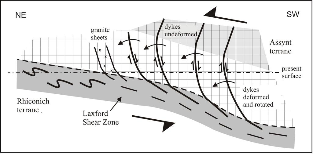
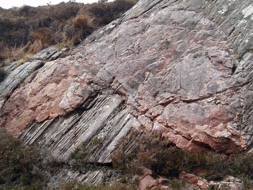
13 localised foliation (Beach, 1974). A hornblende grain shape lineation within these zones plunges moderately south-east, approximately parallel to the earlier Inverian lineation, but the sense of movement is changed to oblique, sinistral and north side up (Beach et al. 1974). These Laxfordian shear zones only occupy a relatively small proportion (<10%) of the outcrop area, but the sum of movement associated with them may be of the order of tens of kilometres (Coward, 1990; Beach, 1974). Away from these narrow shear zones the overall Laxfordian strain in the southern and central parts of the LSZ appears to be very low, although Laxfordian strain within the gneisses is hard to distinguish from Inverian effects in areas where Scourie Dykes are absent. Minor folding of dyke margins appears to be restricted to the Laxfordian shear zones(beach et al. 1974). There is no evidence throughout the south-central parts of the LSZ for any large-scale Laxfordian folds. The Scourie Dykes maintain their NW SE trend throughout the southern and central parts of the LSZ; although they are displaced by the discrete Laxfordian shear zones, they show no tendency to rotate overall into a more WNW ESE orientation parallel to these shear zones. In the model suggested by Coward (1974) the Inverian shear zone acts as an antithetic south-down shear zone which rotates in an anticlockwise fashion, looking north-east, during the Laxfordian. Thus the south-down sinistral shear sense exhibited by the steeply dipping Laxfordian shear zones where they cut the Scourie Dykes is a response to horizontal north-directed shear (Figure 4). In some places the Scourie Dykes deflect into and follow the zones of Inverian shear for a short distance, or send small veins parallel to them (e.g. south of Tarbet at NC ). These deviations from the normal trend of the dykes can often be shown to be intrusive features and not due to later Laxfordian deformation, as first deduced by Clough (in Peach et al. 1907; see also Park & Cresswell 1972). Within the central part of the LSZ, scattered biotite granite and granitic pegmatite sheets up to 10 m thick cut across the mafic/ultramafic bodies, the semipelitic gneisses, and the quartzofeldspathic gneisses (e.g. south of Badnabay at NC ). Some of the granitoid sheets carry a weak Laxfordian fabric, but they clearly cross-cut the dominant Inverian foliation (Figure 5). In some cases the granite sheets are axial-planar to small-scale upright Laxfordian folds. The relationship between these granite sheets and the discrete Laxfordian shear belts described above is unclear. However, it is important to note that these granitic sheets cut rocks (such as the 13
14 mafic/ultramafic gneisses and metasedimentary gneisses) that are generally agreed to belong to the Assynt terrane, contrary to the suggestion of Friend and Kinny (2001) that the granitic sheets occur only in the Rhiconich terrane. The northern part of the Laxford Shear Zone The northern part of the LSZ is equivalent to the Badnabay zone of Sutton and Watson (1951) (Figure 2b). It is characterised by the presence of abundant sheets of granite and granitic pegmatite, varying in thickness from 1 to 100 m, which cut highly strained gneisses (Figure 6). The thicker granites are weakly foliated and are mostly concordant with the main foliation in the gneisses. This strong foliation dips steeply towards the south-west, and is essentially indistinguishable from the Inverian foliation in the southern and central parts of the LSZ. However, in the northern part of the LSZ this main fabric has been identified as Laxfordian in age (Coward, 1990). This conclusion is difficult to confirm due to the apparent absence of Scourie Dykes within the northern part of the LSZ, although the closest Scourie Dykes do seem to be strongly thinned (Peach et al., 1892; Figure 2a) this indicates that at least some of the deformation is Laxfordian, but it may have been superimposed upon significant Inverian deformation. Sutton and Watson (1951) defined the southern boundary of their Badnabay zone by the incoming of abundant, weakly foliated granitic sheets (the Rubha Ruadh granites). It is of course very difficult to draw a boundary along the southern side of the zone of abundant granitic sheets since the definition of abundant is naturally subjective. The most likely candidate for such a boundary would be the margin of a ~ 50 m thick granitic sheet, which forms steep cliffs on the northern slopes of Ben Stack, and extends north-west as far as Badnabay, beyond which it divides into thinner sheets that die out along strike (Figure 2a). The margin of this thick granitic sheet (and its extensions to the west) is discordant with the trend of the main foliation (as noted by Beach et al., 1974). Furthermore, as described above, a number of weakly foliated to undeformed granite sheets up to 10 m thick occur to the south of this main granite sheet. The boundary between the Assynt and Rhiconich terranes, which is considered to lie within the northern part of the LSZ, should separate banded tonalitic gneisses with mafic, garnetiferous amphibolitic pods, from migmatitic granodioritic gneisses to the 14
15 north. This boundary cannot be defined as a sharp line on the ground. Around Loch Stack, it is typically obscured by thick granite sheets, but to the west it can be traversed at a number of localities. There are some localities where the boundary can be placed to within around one hundred metres; for example, in the A894 road cuts close to Loch na Claise Fearna (NC ), outcrops of mafic and ultramafic rocks with associated metasedimentary units rapidly give way northwards to migmatitic gneisses. However, in other places the boundary appears much more gradational on a scale of hundreds of metres, with the incoming of increasing amounts of granodioritic material to the north. On the south side of Loch Laxford, near Rubha Ruadh, abundant granitic sheets cut tonalitic gneisses with mafic to ultramafic lenses, which appear to belong to the Assynt terrane (Figure 6). The Rhiconich terrane north of the Laxford Shear Zone To the north of Loch Laxford and the Laxford River (Figure 2a), thick granitic sheets (> 10 m) are much less common, and the rocks are chiefly migmatitic amphibolitefacies gneisses with an extensive, anastomosing network of thinner sheets of granite and pegmatitic granite. The migmatitic gneisses of this area are grey to pink in colour and broadly granodioritic in composition. Small mafic enclaves occur locally, but rarely exceed 1 m in size; large garnet amphibolite bodies are not found. At the northern margin of the LSZ the main (Laxfordian) foliation dips steeply to the southwest in parallel with that within the LSZ (Figure 3). To the north, the foliation becomes less steep and gradually bends over to a sub-horizontal attitude at the crest of the Rhiconich antiform. The foliation is associated with a moderately south-eastplunging lineation similar to that in the LSZ. In some places, the granitic sheets make up > 50% of the outcrop area. They are commonly irregular in shape, cross-cut the gneissose layering, and are themselves weakly foliated to undeformed. Locally, foliation-parallel migmatitic leucosomes can be traced into cross-cutting pegmatitic sheets (e.g. in road-cuts near Rhiconich at NC ), indicating that these intrusive sheets are largely formed by partial melting of local crust. This was apparently confirmed by Rb-Sr and Pb isotopic data for granites north of the LSZ which indicated crustal sources (Taylor et al., 1984). More recent experimental work (Watkins et al., 2007) has suggested that the composition of the granitic sheets could not be produced by the melting of local crustal sources in the Rhiconich terrane although the parent gneisses used in their experiments had 15
16 unusually low K 2 O/Na 2 O ratios when compared with the average compositions for gneisses north of the LSZ given by Holland and Lambert (1973). The origin of the granitic sheets in the Rhiconich terrane is therefore uncertain. Amphibolite sheets that are interpreted as part of the Scourie Dyke Swarm are common in the region north of Loch Laxford. They are pervasively deformed, with a strong Laxfordian foliation, and are sub-parallel to the main gneissose layering, although local low-angle discordances indicate that the dykes post-date the gneissosity as in the Assynt terrane. The dykes, together with the gneissose layering, are affected by a set of north-east-verging asymmetric overfolds on a scale of metres (Beach et al., 1974). The granite and pegmatite sheets cut both the Laxfordian foliation in the dykes and the overfolds, being in some cases parallel to the fold axial planes. Correlation of structures across the Laxford Shear Zone depends on the identification of the dykes in the Rhiconich terrane as part of the Scourie Dyke Swarm. If this correlation is accepted, the pre-dyke foliation in the north could be correlated with the Inverian further south. There are however, significant differences in the post-dyke (Laxfordian) structure across the LSZ, the most obvious being the much greater intensity of Laxfordian deformation and folding in the north. These differences in deformation are most simply explained by the competence differences between the granulite-facies Assynt terrane and the more ductile gneisses of the Rhiconich terrane; experimental evidence shows that anhydrous granulite-facies rocks are significantly more competent than hydrous amphibolite-facies rocks (e.g. Wilks and Carter, 1990). The Inverian shear zone provided a convenient boundary along which the high Laxfordian strain was focused into the more ductile rocks of the Rhiconich terrane. Geochemical characteristics of the Assynt and Rhiconich terranes The Laxford Shear Zone separates two areas with very different geochemical characteristics; the gneisses of the Assynt terrane are conspicuously depleted in K, Rb, Th and U, and have very high K/Rb ratios, when compared to the gneisses of the Rhiconich terrane (Sheraton et al., 1973; Holland and Lambert, 1973). The origin of these differences has been the subject of extensive debate, the conclusions of which have important implications for the terrane model. 16
17 The characteristic alkali element depletion in the Assynt terrane gneisses has been widely attributed to removal of these elements by CO 2 -rich fluids during granulitefacies metamorphism (Sheraton et al., 1973; Hamilton et al., 1979; Weaver and Tarney, 1981a), although it has also been suggested that the gneisses represent the residuum left after the removal of partial melts (Pride and Muecke, 1980; Cartwright and Barnicoat, 1987). However, Tarney and Weaver (1987) raised the possibility that the element depletions seen in the Assynt terrane could be a primary feature of the original igneous intrusions, related to the subduction-zone processes through which the original magmas were formed. This idea was supported by the work of Cartwright and Valley (1992) who used oxygen isotope data to show that large volumes of fluid did not pass through the gneisses of the Assynt terrane during granulite-facies metamorphism, whilst Rollinson (1994) provided arguments against partial melting. More recently, Rollinson (1996) and Rollinson and Tarney (2005) have argued that the geochemical features of the Assynt terrane are indeed primary igneous features, with the original magmas being derived from a subducting slab that has undergone incremental melting and early removal of the fluid-mobile elements. Recent work has revived the older idea that the gneisses of the Rhiconich terrane were originally also depleted, but were metasomatically enriched in K, Rb, Th and U, causing partial melting and migmatisation, during the Laxfordian (Sutton and Watson, 1951; Castro, 2004). Although the introduction of fluid may well have played some role in the Laxfordian migmatisation, it is likely that such metasomatism would have been localised along shear zones, and that it would be possible to find unmetasomatised regions that preserved a pre-laxfordian composition. Examples of this process have been demonstrated in granulite facies gneisses in the Bergen Arcs (Austrheim, 1987). In the Rhiconich terrane, all the gneisses even away from areas of intense deformation and migmatisation have similar K, Rb, Th and U contents (Weaver and Tarney, 1981a). It therefore appears most likely that the geochemical differences in the gneisses across the Laxford Shear Zone are a primary feature, due to distinctly different protolith geochemistries, rather than being related to metamorphic histories. The gneisses of the Assynt terrane were most probably formed from magmas derived by melting of a subducting slab (Rollinson and Tarney, 2005), whereas the chemistry of the Rhiconich gneisses is more like that of modern-day calc-alkaline igneous rocks, and 17
18 the most likely origin for the magmas is in the mantle wedge above the subducting slab. The geochemistry thus does indicate that there were differences in the process of crust formation to the north and south of the Laxford Shear Zone (Rollinson, 1996). As part of the recent BGS mapping of the area, Scourie Dykes from the Rhiconich terrane were sampled and analysed for major and trace elements (Table 1). These data can be compared with the geochemistry of the Scourie Dykes in the Assynt terrane, which has been studied by Weaver and Tarney (1981b). There is considerable geochemical variation within the Scourie Dykes of the Assynt terrane, and the samples from the Rhiconich terrane lie within the same range. On multi-element plots (Figure 7), all the dykes from both terranes are characterised by negative Nb anomalies, which have typically been considered to be a feature of the lithospheric mantle source of the Scourie Dykes (Weaver and Tarney, 1981b). The Scourie Dykes from within the Rhiconich terrane do typically have higher K and Rb contents than those within the Assynt terrane, but this can almost certainly be attributed to contamination of the magmas by the surrounding gneisses. Overall, the geochemical data indicate that Scourie Dykes from both the Rhiconich and Assynt terranes are likely to be part of the same dyke swarm. Does the Laxford Shear Zone separate two distinct terranes? The concept of separate terranes that have been accreted to form a now-contiguous tectonic belt was developed in the North American Cordillera. Terranes were described as blocks of crust that are characterised by internal homogeneity and continuity of stratigraphy, tectonic style and history with the boundaries between terranes being fundamental discontinuities in stratigraphy that separate totally distinct temporal or physical rock sequences (Coney et al., 1980). Boundaries between terranes were considered as faults that usually display complex structural history. Several lines of evidence support the recognition of different terranes to the north and south of the Laxford Shear Zone. Field and petrographical evidence clearly indicates different metamorphic histories across the Laxford Shear Zone in particular the existence of a granulite-facies metamorphic event that affected the whole of the Assynt terrane but for which there is no evidence in the Rhiconich terrane. 18
19 SIMS U-Pb zircon dating has showed that the protolith ages of gneisses in the Rhiconich terrane ( Ma) are different from those in the Assynt terrane ( Ma) (Kinny and Friend, 1997). A metamorphic event at c Ma in the Assynt terrane (Corfu et al., 1994; Kinny and Friend, 1997) has not been identified in samples from the Rhiconich terrane. The gneisses of the Assynt terrane are strongly depleted in K, Rb, Th and U, and have very high K/Rb ratios, when compared to the gneisses of the Rhiconich terrane (Sheraton et al., 1973; Holland and Lambert, 1973). These geochemical differences are considered to be igneous rather than metamorphic (Rollinson and Tarney, 2005). The Laxford Shear Zone is a major structure with a complex structural history. As pointed out by Park (2005), it is possible for rocks with different protolith ages and geochemistries to occur within the same terrane, simply representing plutons intruded at different ages but adjacent to each other. However, in the example under discussion here, it is clear that the plutonic rocks to the north and south of the Laxford Shear Zone have undergone different metamorphic histories, before being juxtaposed along a major ductile shear zone. When considered together, the variation in protolith ages, metamorphic histories, and protolith geochemistry provide evidence that the Laxford Shear Zone separates two blocks of crust that are both temporally and physically distinct. In this respect, the LSZ satisfies the criteria laid out by Coney et al. (1980) for a terrane boundary. However, it must be noted that the relative position of these terranes, prior to their juxtaposition, has not been quantified. When were the two terranes juxtaposed? There is little doubt that the two terranes were separated at the time that granulitefacies metamorphism (the Badcallian event) took place in the Assynt terrane, since there is no field, petrographical or geochronological evidence for this event in the Rhiconich terrane. The absolute age of this event is uncertain (Corfu, 2007; Friend et al., However, a metamorphic event which occurred at c Ma in the Assynt terrane (Corfu et al., 1994; Kinny and Friend, 1997) has not been identified in zircons from the Rhiconich terrane, and this may indicate that the two terranes were separate up to this point (Friend and Kinny, 2001). 19
20 The first event that appears to be common to both terranes is the intrusion of the Scourie Dykes. The Scourie Dykes in the Assynt terrane have been dated as c Ma (Heaman and Tarney, 1989; Waters et al., 1990); no examples have been dated from the Rhiconich terrane. As discussed above, the field relationships and geochemistry of the dykes in the Rhiconich terrane are compatible with their being part of the Scourie Dyke Swarm, and it is therefore possible that the two terranes were juxtaposed by the time of Scourie Dyke intrusion. Unfortunately, no Scourie Dykes can be traced that cut right across the Laxford Shear Zone; the early mapping indicated that they are strongly thinned into the area of intense Laxfordian deformation in the northern part of the LSZ (Peach et al., 1892). In their development of a terrane model, Friend and Kinny (2001) made the assumption that Laxfordian granite sheets (the Rubha Ruadh granites ) only occur in the Rhiconich terrane. On this basis, having dated one of these granite sheets at 1854 ± 13 Ma, they suggested that the terranes must have been juxtaposed following the emplacement of the granites. However, as described above, further study of the field relationships shows that some granite sheets cut mafic-ultramafic bodies and metasedimentary gneisses that are generally agreed to be part of the Assynt terrane, as originally recognised by Sutton and Watson (1951), and the granites therefore stitch the two terranes. No dates have yet been published for these granites within the Assynt terrane, but on the basis of field relationships they appear likely to be related to the Rubha Ruadh granites. It has been shown that partial melting of Archaean granulite-facies tonalitic gneisses, like those of the Assynt terrane, only produces very small amounts of magma (Castro, 2004). In contrast, it is likely that the gneisses of the Rhiconich terrane, with higher amounts of the fusible, heat-producing elements and higher contents of hydrous mineral phases, could produce significantly larger volumes of partial melt. Thus, we suggest that partial melting and formation of granitic magmas occurred preferentially on the north side of the Laxford Shear Zone, with only limited intrusion of granites on the southern side. Similarly, later Laxfordian deformation was preferentially taken up by the more ductile gneisses to the north. The heat source that caused the partial melting is unknown, but it is possible that it may have been due to the introduction of more primitive, mantle-derived magma into the base of the crust. However, the only mafic magmatism known around that time is the South Harris Complex of the Outer 20
21 Hebrides Lewisian, which was intruded at c Ma (Whitehouse and Bridgwater, 2001; Mason et al., 2004), some time prior to the formation of the Rubha Ruadh granites. We have shown that the two terranes were certainly juxtaposed prior to c Ma granite intrusion, and probably prior to Ma Scourie Dyke intrusion, but clearly after the Badcallian granulite-facies metamorphism in Assynt. We therefore suggest that the two terranes were brought together during the first and most pervasive phase of deformation on the LSZ; the Inverian event. During this event, deformation was focused along the terrane boundary as the granulite-facies gneisses of the Assynt terrane were thrust over the gneisses of the Rhiconich terrane (Coward and Park, 1987). It should be noted that the terms Badcallian and Inverian are used here as they were originally defined; that is, as the granulite-facies and amphibolitefacies events, respectively, that occurred prior to the intrusion of the Scourie Dyke Swarm. The absolute age of these events continues to be the subject of a debate (Corfu, 2007; Friend et al., 2007), which cannot be resolved by the evidence presented here. Conclusions This reappraisal of the Laxford Shear Zone highlights the importance of integrating field observations with geochronological and geochemical data in the development of any geological model for high-grade gneiss areas. There is significant evidence to show that the Assynt and Rhiconich terranes represent separate blocks of crust with very differing histories: the geochemical data illustrate differences in their petrogenesis, whilst geochronological, petrological and field data show that the Assynt terrane has experienced a granulite-facies tectonic event that did not affect the Rhiconich terrane. These two separate terranes were juxtaposed along the major Laxford Shear Zone, which was a locus for both Inverian and Laxfordian deformation. Reappraisal of the field relations has indicated that Laxfordian granites occur across the Laxford Shear Zone and thus it is likely that the terranes were juxtaposed prior to the Laxfordian event. We therefore suggest that terrane juxtaposition occurred during the Inverian event, the exact age of which is as yet uncertain (although it is likely that it occurred relatively soon after the Archaean Proterozoic boundary at c Ma). The 21
22 terrane-bounding shear zone was substantially reactivated during the Laxfordian, as a site of both deformation and magmatism. Many questions remain to be answered with reference to the formation of the Laxford Shear Zone. How much movement was there along the LSZ in the Inverian, and what exactly were the kinematics of shearing? Do the mafic-ultramafic and metasedimentary rocks found within the LSZ represent a fragment of ocean floor that once separated the terranes and that was then accreted to the continental margin, as suggested by Park and Tarney (1987) or were the two crustal blocks formed at a distance from each other within the same continental mass, and subsequently moved together? How can we harness the different available techniques to improve our interpretation of the complex zircons found in the Lewisian gneisses, and thus reach a consensus on the dates of the main events? What, indeed, is the absolute age of the Inverian, and was this a time of more regional terrane amalgamation? What were the tectonic processes that were operating at the end of the Archaean to bring these terranes together? As ever, the rocks of the Lewisian Gneiss Complex remain a fruitful subject for further research Acknowledgements Rob Butler, Bob Holdsworth, Maarten Krabbendam, Rick Law and Rob Strachan organised the conference in Ullapool that stimulated our discussions on the Laxford Shear Zone. Randy Parrish, Martin Hand and John Mendum, as well as many other participants of the Ullapool conference, are thanked for discussions in the field. Editorial comments by Rob Strachan, constructive reviews by Hugh Rollinson and Martin Whitehouse, and comments on an earlier version by Roger Key and Martin Smith, were much appreciated. KMG, MK, QC and SCL publish with the permission of the Executive Director of the Geological Survey
23 Attfield, P The structural history of the Canisp Shear Zone. In: Park, R. G. and Tarney, J. (eds) Evolution of the Lewisian and comparable Precambrian highgrade terrains, Geological Society of London Special Publication 27, Austrheim, H Eclogitization of lower crustal granulites by fluid migration through shear zones. Earth and Planetary Science Letters, 81, Beach, A The Scourie-Laxford Region (Lewisian). In: Barber, A. J., Beach, A., Park, R. G., Tarney, J. and Stewart, A. D. (eds) Geologists' Association Guide No. 21: The Lewisian and Torridonian rocks of North-West Scotland. The Geologists' Association, London. Beach, A The Measurement and Significance of Displacements on Laxfordian Shear Zones, North-West Scotland. Proceedings of the Geologists Association, 85, Beach, A., Coward, M. P. and Graham, R. H An interpretation of the structural evolution of the Laxford front. Scottish Journal of Geology, 9, Bowes Untitled discussion. Proceedings of the Geological Society of London, 1594, Cartwright, I., Fitches, W.R., O Hara, M.J., Barnicoat, A.C., and O Hara, S Archaean supracrustal rocks from the Lewisian near Stoer, Sutherland. Scottish Journal of Geology 21, Cartwright, I. and Barnicoat, A. C Petrology of Scourian supracrustal rocks and orthogneisses from Stoer, NW Scotland: implications for the geological evolution of the Lewisian complex. In: Park, R. G. and Tarney, J. (eds) Evolution of the Lewisian and comparable Precambrian high-grade terrains, Geological Society of London Special Publication 27, Cartwright, I. and Valley, J. W Oxygen-isotope geochemistry of the Scourian complex, northwest Scotland. Journal of the Geological Society of London, 149, Castro, A The source of granites: inferences from the Lewisian complex. Scottish Journal of Geology, 40, Corfu, F., Heaman, L. M. and Rogers, G Polymetamorphic evolution of the Lewisian complex, NW Scotland, as recorded by U-Pb isotopic compositions of zircon, titanite and rutile. Contributions to Mineralogy and Petrology, 117, Corfu, F Comment to paper: Timing of magmatism and metamorphism in the Gruinard Bay area of the Lewisian gneiss complex: comparison with the Assynt Terrane and implications for terrane accretion. Contributions to Mineralogy and Petrology, 153, Coney, P. J., Jones, D. L., and Monger, J. W. H Cordilleran suspect terranes. Nature, 288, Coward, M. P Flat lying structures within the Lewisian basement gneiss complex of NW Scotland. Proceedings of the Geologists Association, 85, Coward, M. P Shear zones at the Laxford front, NW Scotland and their significance in the interpretation of lower crustal structure. Journal of the Geological Society of London, 147, Coward, M. P. and Park, R. G The role of mid-crustal shear zones in the Early Proterozoic evolution of the Lewisian. In: Park, R. G. and Tarney, J. (eds) Evolution of the Lewisian and comparable Precambrian high grade terrains. Geological Society of London Special Publication 27, Davies, F. B A layered basic complex in the Lewisian, south of Loch Laxford, 23
24 Sutherland. Journal of the Geological Society of London, 130, Davies, F. B Early Scourian structures in the Scourie-Laxford region and their bearing on the evolution of the Laxford Front. Journal of the Geological Society of London, 132, Evans, C. R Geochronology of the Lewisian basement near Lochinver, Sutherland. Nature, 207, Evans, C. R. and Lambert, R. S. J The Lewisian of Lochinver: the type area for the Inverian metamorphism. Journal of the Geological Society of London, 130, Friend, C. R. L. and Kinny, P. D New evidence for protolith ages of Lewisian granulites, northwest Scotland. Geology, 23, Friend, C. R. L. and Kinny, P. D A reappraisal of the Lewisian Gneiss Complex: geochronological evidence for its tectonic assembly from disparate terranes in the Proterozoic. Contributions to Mineralogy and Petrology, 142, Friend, C.R.L., Kinny, P.D. and Love, G.J Timing of magmatism and metamorphism in the Gruinard Bay area of the Lewisian gneiss complex: comparison with the Assynt Terrane and implications for terrane accretion - reply. Contributions to Mineralogy and Petrology, 153, Giletti, B. J., Moorbath, S. and Lambert, R. S. J A geochronological study of the metamorphic complexes of the Scottish Highlands. Quarterly Journal of the Geological Society of London, 117, Hamilton, P. J., Evensen, N. M., O'Nions, R. K. and Tarney, J Sm-Nd systematics of Lewisian gneisses: implications for the origin of granulites. Nature, 277, Heaman, L. and Tarney, J U-Pb baddeleyite ages for the Scourie dyke swarm, Scotland: evidence for two distinct intrusion events. Nature, London, 340, Holland, J. G Geochemical studies in the Lewisian. Unpublished Thesis, Oxford University Holland, J. G. and Lambert, R. S. J Comparative major element geochemistry of the Lewisian of the mainland of Scotland. In: Park, R. G. and Tarney, J. (eds) The early Precambrian of Scotland and related rocks of Greenland. University of Keele, Keele, Kinny, P. and Friend, C U-Pb isotopic evidence for the accretion of different crustal blocks to form the Lewisian Complex of Northwest Scotland. Contributions to Mineralogy and Petrology, 129, Kinny, P. D., Friend, C. R. L. and Love, G.J Proposal for a terrane-based nomenclature for the Lewisian Complex of NW Scotland. Journal of the Geological Society of London, 162, Lambert, R. S. J. and Holland, J. G A geochronological study of the Lewisian from Loch Laxford to Durness, Sutherland, NW Scotland. Quarterly Journal of the Geological Society of London, 128, Love, G.J The origins and accretionary development of the Lewisian Gneiss Complex of Northwest Scotland: constraints from in situ U-Pb and Hf isotopic analysis of accessory minerals. Unpublished PhD Thesis, Curtin University of Technology. Mason, A. J. and Brewer, T. S A re-evaluation of a Laxfordian terrane boundary in the Lewisian Complex of South Harris, NW Scotland. Journal of the Geological Society of London, 162,
25 Mason, A. J., Parrish, R. R. and Brewer, T. S U-Pb geochronology of Lewisian orthogneiss in the Outer Hebrides, Scotland: implications for the tectonic setting and correlation of the South Harris Complex. Journal of the Geological Society of London, 161, Okeke, P. O., Borley, G. D. and Watson, J A geochemical study of Lewisian metasedimentary granulites and gneisses in the Scourie-Laxford area of northwest Scotland. Mineralogical Magazine, 47, 1-9. Park, R. G Observations on Lewisian chronology. Scottish Journal of Geology, 6, Park, R. G The Lewisian terrane model: a review. Scottish Journal of Geology, 41, Park, R. G. and Cresswell, D Basic dykes in the early Precambrian (Lewisian) of NW Scotland: their structural relations, conditions of emplacement and orogenic significance. Reports of the 24th International Geological Congress, Montreal, 1, Park, R. G., Stewart, A. D. and Wright, D. T The Hebridean terrane. In: Trewin, N. H. (ed) The Geology of Scotland. The Geological Society, London, Park, R. G. and Tarney, J The Lewisian complex: a typical Precambrian highgrade terrain? In: Park, R. G. and Tarney, J. (eds) Evolution of the Lewisian and Comparable Precambrian High Grade Terrains, Geological Society of London Special Publication, 27, Peach, B. N., Horne, J., Gunn, W., Clough, C. T., Hinxman, L. W. and Cadell, H. M Geological Survey of Scotland Sheet 107, Lochinver. Ordnance Survey, Southampton. Peach, B. N., Horne, J., Gunn, W., Clough, C. T., Hinxman, L. W. and Teall, J. J. H The geological structure of the North-West Highlands of Scotland. Memoir of the Geological Survey of Great Britain. HMSO, Glasgow. Pride, C. and Muecke, G. K Rare Earth Element Geochemistry of the Scourian Complex NW Scotland - Evidence for the Granite - Granulite Link. Contributions to Mineralogy and Petrology, 73, Ramsay, J. G. and Graham, R. H Strain variation in shear belts. Canadian Journal of Earth Sciences, 7, Rollinson, H. and Tarney, J Adakites - the key to understanding LILE depletion in granulites. Lithos, 79, Rollinson, K. R Tonalite-trondhjemite-granodiorite magmatism and the genesis of Lewisian crust during the Archaean. In: Brewer, T. S. (ed.) Precambrian Crustal Evolution in the North Atlantic Region, Geological Society of London Special Publication, 112, Rollinson, H. R Origin of felsic sheets in the Scourian granulites: new evidence from rare earth elements. Scottish Journal of Geology, 30, Sheraton, J. W., Skinner, A. C. and Tarney, J The geochemistry of the Scourian gneisses of the Assynt district. In: Park, R. G. and Tarney, J. (eds) The early Precambrian of Scotland and related rocks of Greenland, University of Keele, Keele, Sutton, J. and Watson, J. V The pre-torridonian metamorphic history of the Loch Torridon and Scourie areas in the northwest Highlands, and its bearing on the chronological classification of the Lewisian. Quarterly Journal of the Geological Society of London, 106, Sutton, J. and Watson, J. V Further observations on the margin of the 25
26 Laxfordian complex of the Lewisian near Loch Laxford, Sutherland. Transactions of the Royal Society of Edinburgh, 65, Tarney, J. and Weaver, B. L Mineralogy, petrology and geochemistry of the Scourie dykes: petrogenesis and crystallisation processes in dykes intruded at depth. In: Park, R. G. and Tarney, J. (eds) Evolution of the Lewisian and comparable Precambrian high grade Terrains, Geological Society of London Special Publication, 27, Taylor, P.N., Jones, N.W., and Moorbath, S Isotopic assessment of relative contributions from crust and mantle sources to the magma genesis of Precambrian granitoid rocks. Philosophical Transactions of the Royal Society of London, A 310, Waters, F. G., Cohen, A. S., O'Nions, R. K. and O'Hara, M. J Development of Archaean lithosphere deduced from chronology and isotope chemistry of Scourie Dykes. Earth and Planetary Science Letters, 97, Watkins, J.M., Clemens, J.D., and Treloar, P.J Archaean TTGs as sources of younger granitic magmas: melting of sodic metatonalites at GPa. Contributions to Mineralogy and Petrology, 154, Weaver, B. L. and Tarney, J. 1981a. Lewisian gneiss geochemistry and Archaean crustal development models. Earth and Planetary Science Letters, 55, Weaver, B. L. and Tarney, J. 1981b. The Scourie Dyke Suite: Petrogenesis and Geochemical Nature of the Proterozoic Sub-Continental Mantle. Contributions to Mineralogy and Petrology, 78, Wheeler, J. (2009). Reference in this volume. Whitehouse, M. J Sm-Nd evidence for diachronous crustal accretion in the Lewisian complex of northwest Scotland. Tectonophysics, 161, Whitehouse, M.J. and Bridgwater, D Geochronological constraints on Palaeoproterozoic crustal evolution and regional correlations of the northern Outer Hebridean Lewisian Complex, Scotland. Precambrian Research, 105, Wilks, K. R. and Carter, N. L Rheology of some continental lower crustal rocks. Tectonophysics, 182, Zhu, X.K., O Nions, R.K., Belshaw, N.S. and Gibb, A. J Lewisian crustal history from in situ SIMS mineral chronometry and related metamorphic textures. Chemical Geology, 136,
27 Figure captions Figure 1: Simplified geological map of the North-west Highlands, showing the outcrop of the Lewisian Gneiss Complex and the position of the Laxford Shear Zone. Figure 2(a): Simplified geological map of the area around the Laxford Shear Zone, based on recent BGS mapping and the 19 th century BGS survey (Peach et al., 1892). Ticks indicate British National Grid. Figure 2(b): The zones identified by Sutton and Watson (1951), superimposed upon the map as in Figure 2a. 1 indicates the local Laxfordian Front of Sutton and Watson (1951); 2 indicates the Ben Stack Line of Lambert and Holland (1972). Figure 3: Sketch cross-section through the Laxford Shear Zone, modified after Beach et al. (1974). Not to scale. Figure 4: Interpretation of the Laxfordian structures across the Laxford front in terms of a gently southward-inclined shear zone with a top to the north sense of shear (after Coward, 1974). Figure 5: Photo of pink Laxfordian granite sheet cutting gneisses with a strong Inverian foliation in the central part of the Laxford Shear Zone [NC ]. Field of view c. 5 m across. BGS photo P593114, NERC. Figure 6: Photo of pink Laxfordian granite sheets cutting tonalitic gneisses with mafic and ultramafic lenses, in the northern part of the Laxford Shear Zone [NC ]. Graham Park for scale. Photo John Myers. Figure 7: Primitive mantle-normalised trace-element plot for Scourie Dykes north and south of the Laxford Shear Zone. Data for all groups of Scourie Dykes from Assynt from Weaver and Tarney (1981b). Data for Rhiconich Scourie Dykes from Table 1. Table 1: Major and trace element data for Scourie Dykes from the Rhiconich terrane. Analyses were carried out by XRF, using the PW2400 spectrometer and standard procedures employed by the UKAS-accredited analytical labs at BGS Keyworth. 27
28 Sample KG 099 KG 101 KG 103 KG 104 KG 105 KG 106 KG 107 Grid reference NC NC NC NC NC NC NC SiO2 wt% TiO2 wt% Al2O3 wt% Fe2O3t wt% Mn3O4 wt% MgO wt% CaO wt% Na2O wt% K2O wt% P2O5 wt% LOI wt% Total wt% Sc ppm V ppm Cr ppm > Co ppm Ni ppm Cu ppm Zn ppm Ga ppm Rb ppm Sr ppm Y ppm Zr ppm Nb ppm Ba ppm La ppm < Ce ppm Nd ppm Sm ppm < Yb ppm 1 6 < Hf ppm <
29
30

31
32
33
34

35
2 Britain s oldest rocks: remnants of
 Britain s oldest rocks: remnants of Archaean crust 15 2 Britain s oldest rocks: remnants of Archaean crust 2.1 Introduction Owing to the complex nature of extremely old deformed rocks, the standard methods
New U-Pb age constraints for the Laxford Shear Zone, NW Scotland: Evidence for tectono-magmatic processes associated with the formation of
 *Manuscript Click here to view linked References 1 2 3 New U-Pb age constraints for the Laxford Shear Zone, NW Scotland: Evidence for tectono-magmatic processes associated with the formation of a Paleoproterozoic
The South Barra Shear Zone: A Composite Inverian-Laxfordian Shear Zone. and Possible Terrane Boundary in the Lewisian Gneiss Complex of the Isle of
 1 2 3 The South Barra Shear Zone: A Composite Inverian-Laxfordian Shear Zone and Possible Terrane Boundary in the Lewisian Gneiss Complex of the Isle of Barra, Northwest Scotland 4 5 6 7 8 JOHN M. MACDONALD
IMSG Post-conference Field Guide
 IMSG 2017 - Post-conference Field Guide Jérémie Lehmann, Marlina Elburg and Trishya Owen-Smith The purpose of this short field excursion on Wednesday 18 January is to show a variety of rocks that make
CHAPTER VI CONCLUSIONS
 CHAPTER VI CONCLUSIONS In this Chapter, salient observations made in understanding the various tectonothermal events, including U-Pb in-situ monazite geochronology of Sargur schists and granulites exposed
Mafic dyke remnants in the Lewisian Complex of the Outer Hebrides, NW scotland: a geochemical record of continental break-up and re-assembly
 Precambrian Research 133 (2004) 121 141 Mafic dyke remnants in the Lewisian Complex of the Outer Hebrides, NW scotland: a geochemical record of continental break-up and re-assembly A.J. Mason, T.S. Brewer
6 Exhumation of the Grampian
 73 6 Exhumation of the Grampian mountains 6.1 Introduction Section 5 discussed the collision of an island arc with the margin of Laurentia, which led to the formation of a major mountain belt, the Grampian
Durham Research Online
 Durham Research Online Deposited in DRO: January 0 Version of attached le: Accepted Version Peer-review status of attached le: Peer-reviewed Citation for published item: Vernon, R. and Holdsworth, R.E.
Figure GS-25-1: General geology and domain subdivisions in northwestern Superior Province. 155
 GS-25 ASSEAN LAKE ANCIENT CRUST: AN UPDATE by M.T. Corkery, Ch.O. Böhm 1 and L.M Heaman 1 Corkery, M.T., Böhm, Ch.O. and Heaman, L.M. 2000: Assean Lake ancient crust: an update; in Report of Activities
Appendix A2: Detailed description of all results
 Appendix A2: Detailed description of all results This Appendix presents detailed descriptions of all results in this study. It is presented separately in order to streamline the main paper, and to provide
Report of Activities 2003 Published by: Manitoba Industry, Economic Development and Mines Manitoba Geological Survey, 2003.
 Report of Activities 2003 Published by: Manitoba Industry, Economic Development and Mines Manitoba Geological Survey, 2003. ERRATA: The publisher/department name in the bibliographic reference cited immediately
Structure and history of the Kern Canyon fault system: introduction and thesis overview
 1 Chapter 1 Structure and history of the Kern Canyon fault system: introduction and thesis overview Exposures of fault zones from the surface to deep levels afford an opportunity to study the transition
GEOLOGICAL INVESTIGATION IN THE ISLAND LAKE GREENSTONE BELT, NORTHWESTERN SUPERIOR PROVINCE, MANITOBA (PARTS OF NTS 53E/15 & 16) GS-18
 GS-18") GS-18 GEOLOGICAL INVESTIGATION IN THE ISLAND LAKE GREENSTONE BELT, NORTHWESTERN SUPERIOR PROVINCE, MANITOBA (PARTS OF NTS 53E/15 & 16) by S. Lin, H.D.M. Cameron, E.C. Syme and F. Corfu 1 Lin, S., Cameron,
GS-18 GEOLOGICAL INVESTIGATION IN THE ISLAND LAKE GREENSTONE BELT, NORTHWESTERN SUPERIOR PROVINCE, MANITOBA (PARTS OF NTS 53E/15 & 16) by S. Lin, H.D.M. Cameron, E.C. Syme and F. Corfu 1 Lin, S., Cameron,
TECTONIC AND STRUCTURAL CONTROLS ON INTRUSION- RELATED DEPOSITS IN THE NORTHERN PART OF SREDNA GORA ZONE, BULGARIA NIKOLAY PETROV & KAMELIA NEDKOVA
 TECTONIC AND STRUCTURAL CONTROLS ON INTRUSION- RELATED DEPOSITS IN THE NORTHERN PART OF SREDNA GORA ZONE, BULGARIA NIKOLAY PETROV & KAMELIA NEDKOVA INVESTIGATED AREA Praveshka Lakavica deposit Elatsite
Metamorphic Energy Flow. Categories of Metamorphism. Inherited Protolith Character. Inherited Fabric. Chemical Composition
 Metamorphic Energy Flow Categories of Metamorphism Best, Chapter 10 Metamorphic processes are endothermic They absorb heat and mechanical energy Absorption of heat in orogenic belts Causes growth of mineral
GEOL 3313 Petrology of Igneous and Metamorphic Rocks Study Guide for Final Examination Glen Mattioli
 GEOL 3313 Petrology of Igneous and Metamorphic Rocks Study Guide for Final Examination Glen Mattioli Chapter 5: Crystal-Melt phase diagrams Effect of water pressure on feldspar stability Hypersolvus vs.
Metamorphic Petrology GLY 262 P-T-t paths
 Metamorphic Petrology GLY 262 P-T-t paths Pressure-Temperature-Time (P-T-t) Paths The complete set of T-P conditions that a rock may experience during a metamorphic cycle from burial to metamorphism (and
Overview of 2016 regional bedrock mapping in the Tehery-Wager area, northwestern Hudson Bay, Nunavut
 Overview of 2016 regional bedrock mapping in the Tehery-Wager area, northwestern Hudson Bay, Nunavut Photo: Baker Lake, Nunavut Holly M. Steenkamp*, Canada-Nunavut Geoscience Office Université Laval Natasha
Review of isotope data for Precambrian rocks from the Disko Bugt region, West Greenland
 Review of isotope data for Precambrian rocks from the Disko Bugt region, West Greenland Feiko Kalsbeek and Paul N. Taylor Pb-Pb and Rb-Sr isotope data yield whole-rock isochron ages of c. 2800 Ma for two
Secular Archaean. Pronounced secular trends from. However, also. Cr, intermediate to felsic magmas, and
 Secular Archaean Pronounced secular trends from 1. early sodic granites (TTGs) 2. later potassic granites However, also 1. LILE- & LREE-enriched, high MgO, Mg#, Ni, Cr, intermediate to felsic magmas, and
Classification and Origin of Granites. A Multi-faceted Question
 Classification and Origin of Granites A Multi-faceted Question What is a granite? IUGS classification Based on Modal Mineralogy Plutonic rock with less than 90% mafic minerals Alkali Granite Granite Quartz
Introduction. Introduction. Introduction 10/15/2014. The Agents of Metamorphism. Metamorphism. and Metamorphic Rocks
 Introduction Metamorphism The transformation of rocks, usually beneath Earth's surface, as the result of heat, pressure, and/or fluid activity, produces metamorphic rocks Metamorphism and Metamorphic Rocks
Metamorphic fluids, Naxos, Greece
 Field trip Naxos, Greece, course B, SS 2014: Prof. Dr. J. Urai Metamorphic fluids, Naxos, Greece Tilman Scheele Applied Geosciences EMR, RWTH Aachen Introduction Naxos is located in the central Aegean
Regional GIS based exploration targeting studies in data poor environments
 Regional GIS based exploration targeting studies in data poor environments A case study of gold prospectivity mapping in Nigeria Matthew Greentree, Mathieu Lacorde and Bert De Waele Acknowledgements Australian
The Lewisian Geology of Gairloch, NW Scotland
 The Lewisian Geology of Gairloch, NW Scotland Geological Society Memoirs Society Book Editors A. J. FLEET (CHIEF EDITOR) P. DOYLE F. J. GREGORY J. S. GRIFFITHS A. J. HARTLEY R. E. HOLDSWORTH A. C. MORTON
Topics Laramide Orogeny: Late Cretaceous to Early Eocene Reading: GSA DNAG volume 3, Ch. 6
 Topics Laramide Orogeny: Late Cretaceous to Early Eocene Reading: GSA DNAG volume 3, Ch. 6 Late Cretaceous to early Eocene New patterns developed 5 main regions Tectonic interpretations Post-Laramide events
New geologic mapping + and associated economic potential on northern Hall Peninsula, Baffin Island, Nunavut
 New geologic mapping + and associated economic potential on northern Hall Peninsula, Baffin Island, Nunavut Holly Steenkamp, M.Sc. Regional Mapping Geoscientist David Mate, M.Sc. Chief Geologist November
Chapter 8 10/19/2012. Introduction. Metamorphism. and Metamorphic Rocks. Introduction. Introduction. The Agents of Metamorphism
 Chapter 8 Metamorphism Introduction Metamorphism - The transformation of rocks, usually beneath Earth's surface, as the result of heat, pressure, and/or fluid activity, produces metamorphic rocks During
7 Sedimentation and tectonics at a mid- Ordovician to Silurian active margin
 80 Mountain Building in Scotland 7 Sedimentation and tectonics at a mid- Ordovician to Silurian active margin 7.1 Introduction In mid-ordovician to Silurian times, the Grampian mountains underwent exhumation,
Igneous Rocks. Sedimentary Rocks
 Earth Sciences 083F Plate Tectonics Exercises Plate tectonics is a model for the dynamic behaviour of Earth s lithosphere. Outlining stable areas of lithosphere are narrow zones (plate boundaries) in which
LATE ARCHAEAN FELSIC ALKALINE MAGMATISM: GEOLOGY, GEOCHEMISTRY, AND TECTONIC SETTING
 LATE ARCHAEAN FELSIC ALKALINE MAGMATISM: GEOLOGY, GEOCHEMISTRY, AND TECTONIC SETTING ZOZULYA DMITRY 1, EBY NELSON 2 1 - Geological Institute Kola Science Centre RAS, Apatity, Russia 2 - Department of Environmental,
ACCEPTED MANUSCRIPT. High-precision U-Pb dating of complex zircon from the Lewisian Gneiss Complex of
 High-precision U-Pb dating of complex zircon from the Lewisian Gneiss Complex of Scotland using an incremental CA-ID-TIMS approach Q.G. Crowley a*, R. Key b, S.R. Noble c a School of Natural Sciences,
Evolution of the Slave Province and Abitibi Subprovince Based on U-Pb Dating and Hf Isotopic Composition of Zircon
 Evolution of the Slave Province and Abitibi Subprovince Based on U-Pb Dating and Hf Isotopic Composition of Zircon John W.F. Ketchum 1, Wouter Bleeker 2, William L. Griffin 1, Suzanne Y. O Reilly 1, Norman
1 Potassic adakite magmas and where they come from: a mystery solved?
 1 Potassic adakite magmas and where they come from: a mystery solved? 2 3 John Clemens Kingston University (London) Long Xiao China University of Geosciences (Wuhan) 4 Adakites are volcanic and intrusive
Jonathan A. Nourse Department of Geological Sciences California State Polytechnic University Pomona, CA
 Comparison of Late Cretaceous Plutonic Rocks Across the Left-Lateral San Antonio Canyon Fault, San Gabriel Mountains Daniel E. Heaton Department of Geological Sciences San Diego State University San Diego,
Big Island Field Trip
 Big Island Field Trip Space Still Available Group Airline Tickets May be available if enough people sign on If interested send email to Greg Ravizza Planning Meeting Next Week Will
Geologic Structures. Changes in the shape and/or orientation of rocks in response to applied stress
 Geologic Structures Changes in the shape and/or orientation of rocks in response to applied stress Figure 15.19 Can be as big as a breadbox Or much bigger than a breadbox Three basic types Fractures >>>
Introduction. Introduction. Chapter 7. Important Points: Metamorphism is driven by Earth s s internal heat
 Chapter 7 Metamorphism and Metamorphic Rocks Introduction Metamorphism - The transformation of rocks, usually beneath Earth's surface, as the result of heat, pressure, and/or fluid activity, produces metamorphic
Strike-Slip Faults. ! Fault motion is parallel to the strike of the fault.
 Strike-Slip Faults! Fault motion is parallel to the strike of the fault.! Usually vertical, no hanging-wall/footwall blocks.! Classified by the relative sense of motion. " Right lateral opposite block
GEOLOGY AND GEOCHRONOLOGY OF THE ISLAND LAKE GREENSTONE BELT, NORTHWESTERN SUPERIOR PROVINCE by J. Parks 1, S. Lin 1, M.T. Corkery and D.W.
 GS-17 GEOLOGY AND GEOCHRONOLOGY OF THE ISLAND LAKE GREENSTONE BELT, NORTHWESTERN SUPERIOR PROVINCE by J. Parks 1, S. Lin 1, M.T. Corkery and D.W. Davis 2 Parks, J., Lin, S., Corkery, M.T. and Davis, D.W.
Chapter 21: Metamorphism. Fresh basalt and weathered basalt
 Chapter 21: Metamorphism Fresh basalt and weathered basalt 1 Chapter 21: Metamorphism Metamorphism: Meaning change of form in Greek (meta morph) 2 Chapter 21: Metamorphism The IUGS-SCMR proposed this definition:
Metamorphic Petrology GLY 262 Metamorphism and plate tectonics
 Metamorphic Petrology GLY 262 Metamorphism and plate tectonics Regional Metamorphism in a broad sense: metamorphism that affects a large body of rock, and thus covers a great lateral extent Three principal
Magnetic anomalies and metamorphic boundaries in the southern Nagssugtoqidian orogen, West Greenland
 Magnetic anomalies and metamorphic boundaries in the southern Nagssugtoqidian orogen, West Greenland John A. Korstgård, Bo Møller Stensgaard and Thorkild M. Rasmussen Within the southern Nagssugtoqidian
Lab: Metamorphism: minerals, rocks and plate tectonics!
 Introduction The Earth s crust is in a constant state of change. For example, plutonic igneous rocks are exposed at the surface through uplift and erosion. Many minerals within igneous rocks are unstable
Appendix 11. Geology. of the. I60 area
 Appendix 11 Geology of the I60 area 1. Locality The locality of the I60 area is as follows; Northwestern corner; UTM_EW 530513, UTM_NS 7345741 Southwestern corner; UTM_EW 530418, UTM_NS 7301454 Northeastern
Chapter 4 Rocks & Igneous Rocks
 Chapter 4 Rocks & Igneous Rocks Rock Definition A naturally occurring consolidated mixture of one or more minerals e.g, marble, granite, sandstone, limestone Rock Definition Must naturally occur in nature,
Answers: Internal Processes and Structures (Isostasy)
") Answers: Internal Processes and Structures (Isostasy) 1. Analyse the adjustment of the crust to changes in loads associated with volcanism, mountain building, erosion, and glaciation by using the concept
Answers: Internal Processes and Structures (Isostasy) 1. Analyse the adjustment of the crust to changes in loads associated with volcanism, mountain building, erosion, and glaciation by using the concept
5/1/2017. Why Study Metamorphism? The Limits of Metamorphism. Low-temperature limit grades into diagenesis. Intro. to Metamorphism
 Intro. to Metamorphism 1 Why Study Metamorphism? 2 Why study metamorphism Metamorphic agents & processes Versus igneous & sedimentary processes Interpretation of the conditions and evolution of metamorphic
Chapter 21: Metamorphism. Fresh basalt and weathered basalt
 Chapter 21: Metamorphism Fresh basalt and weathered basalt Chapter 21: Metamorphism The IUGS-SCMR proposed this definition: Metamorphism is a subsolidus process leading to changes in mineralogy and/or
"When Gregor Samsa woke up one morning from unsettling dreams, he found himself changed into a monstrous bug. Metamorphosis, by Franz Kafka
 Metamorphosis "When Gregor Samsa woke up one morning from unsettling dreams, he found himself changed into a monstrous bug. Metamorphosis, by Franz Kafka Metamorphism The transformation of rock by temperature
INTRODUCTION. Basalt, the widespread igneous rock on the earth sur-face. today appear to have been equally important
 INTRODUCTION Basalt, the widespread igneous rock on the earth sur-face today appear to have been equally important in the geologic past. Basaltic rocks are mostly partial melting products of the upper
Metamorphic history of Nuvvuagittuq greenstone belt, Northeastern Superior Province, Northern Quebec, Canada
 Metamorphic history of Nuvvuagittuq greenstone belt, Northeastern Superior Province, Northern Quebec, Canada By: Majnoon, M., Supervisor: Minarik, W.G., Committee members: Hynes, A., Trzcienski, W.E. 1.
Dome formation mechanisms in the southwestern Central Zone of the Damara Orogen, Namibia
 Trabajos de Geología, Universidad de Oviedo, 29 : 440-444 (2009) Dome formation mechanisms in the southwestern Central Zone of the Damara Orogen, Namibia L. LONGRIDGE 1*, R. L. GIBSON 1 AND J. A. KINNAIRD
Lab 6: Metamorphic Rocks
 Introduction The Earth s crust is in a constant state of change. For example, plutonic igneous rocks are exposed at the surface through uplift and erosion. Many minerals within igneous rocks are unstable
Introduction to Prospecting. Session Two Geology
 Introduction to Prospecting Session Two Geology The Earth Earth is 4.6 billion years old (Ba). Bacteria & algae +3.5 Ba. Microscopic animals ~2 Ba. Animals ~600 million years (Ma) old. Mankind about 100,000
7. K-DIFFERENTIATION BY MAGMATIC AND METASOMATIC PROCESSES
 1 ISSN 1526-5757 7. K-DIFFERENTIATION BY MAGMATIC AND METASOMATIC PROCESSES Lorence G. Collins email: lorencec@sysmatrix.net February 3, 1997 The granitic crust began to form about 2.5 billion years ago
Copyright McGraw-Hill Education. All rights reserved. No reproduction or distribution without the prior written consent of McGraw-Hill Education
 Copyright McGraw-Hill Education. All rights reserved. No reproduction or distribution without the prior written consent of McGraw-Hill Education Tibetan Plateau and Himalaya -southern Asia 11.00.a VE 10X
CHAPTER 3.3: METAMORPHIC ROCKS
 CHAPTER 3.3: METAMORPHIC ROCKS Introduction Metamorphism - the process of changes in texture and mineralogy of pre-existing rock due to changes in temperature and/or pressure. Metamorphic means change
GCE AS/A level 1211/01 GEOLOGY GL1 Foundation Unit
 Surname Centre Number Candidate Number Other Names 2 GCE AS/A level 1211/01 GEOLOGY GL1 Foundation Unit S15-1211-01 A.M. MONDAY, 11 May 2015 1 hour For s use Question Maximum Mark 1. 15 2. 14 Mark Awarded
Proterozoic Granites - Australia
 Jan 2007 PS-T Proterozoic Granites - Australia granites widespread (~145,000 km 2 ) Proterozoic Granites - Australia range from (late Neoarchaean-) early Palaeoproterozoic to Neoproterozoic most ca. 1950-1500
Isan deformation, magmatism and extensional kinematics in the Western Fold Belt of the Mount Isa Inlier
 Isan deformation, magmatism and extensional kinematics in the Western Fold Belt of the Mount Isa Inlier Rick Gordon Department of Earth Sciences University of Queensland A thesis submitted for examination
Evolution of Continents Chapter 20
 Evolution of Continents Chapter 20 Does not contain complete lecture notes. Mountain belts Orogenesis the processes that collectively produce a mountain belt Includes folding, thrust faulting, metamorphism,
Deformation of Rocks. Orientation of Deformed Rocks
 Deformation of Rocks Folds and faults are geologic structures caused by deformation. Structural geology is the study of the deformation of rocks and its effects. Fig. 7.1 Orientation of Deformed Rocks
APPENDIX 2 Table 2. Sample descriptions
 Table 2. descriptions 225 Felsic gneiss, fine-grained and very light-gray. From the upper part of the lower of the two layers, which connect. 226 Amphibolite, even-grained, fine-grained, medium-gray, little
Chapter 8 Lecture. Earth: An Introduction to Physical Geology. Twelfth Edition. Metamorphism. Rocks. Tarbuck and Lutgens Pearson Education, Inc.
 Chapter 8 Lecture Earth: An Introduction to Physical Geology Twelfth Edition Metamorphism and dmetamorphic Rocks Tarbuck and Lutgens Chapter 8 Metamorphic Rocks What Is Metamorphism? Metamorphism means
Lecture 5 Sedimentary rocks Recap+ continued. and Metamorphic rocks!
 Lecture 5 Sedimentary rocks Recap+ continued and Metamorphic rocks! Metamorphism Process that leads to changes in: Mineralogy Texture Sometimes chemical composition Metamorphic rocks are produced from
GSTT Technical Note. September 4, Field Trip - Northern Range. Western (Mid-Crustal) Tectonic Domain. STOP 1: Upper Lady Chancellor Road
 Tectonic Domain. STOP 1: Upper Lady Chancellor Road") GSTT Technical Note September 4, 2001 P.O. Box 3524, La Romain, Trinidad and Tobago W.I Web address: www.gstt.org, Editor: millikm1@bp.com Field Trip - Northern Range Systematic east to west variations
GSTT Technical Note September 4, 2001 P.O. Box 3524, La Romain, Trinidad and Tobago W.I Web address: www.gstt.org, Editor: millikm1@bp.com Field Trip - Northern Range Systematic east to west variations
Global Tectonics. Kearey, Philip. Table of Contents ISBN-13: Historical perspective. 2. The interior of the Earth.
 Global Tectonics Kearey, Philip ISBN-13: 9781405107778 Table of Contents Preface. Acknowledgments. 1. Historical perspective. 1.1 Continental drift. 1.2 Sea floor spreading and the birth of plate tectonics.
Undergraduate Review. Jessica Sousa. Volume 4 Article 13
 Undergraduate Review Volume 4 Article 13 2008 Kinematic Analysis of Mylonitic Rocks, Southern Ruby Mountains, SW Montana: Evidence for Proterozoic Orogenic Crustal Thickening and Topographic Collapse Jessica
LAB 6: TRINIDAD BEACH FIELD TRIP
 OBJECTIVES: LAB 6: TRINIDAD BEACH FIELD TRIP 1) to develop your powers of observation, especially of geological phenomena; 2) to identify the rocks exposed at Trinidad Beach; 3) to reconstruct some of
predictive iscovery Why is the gold where it is? redictive mineral ineral discovery pmd CRC
 The Y2 project (2001-2004) Time-space evolution of the Yilgarn Craton: implications for geodynamics Kevin Cassidy and the Y2 team Reduced D Risk through Improved Targeting ineral d Why is the gold where
Archean Terranes. Archean Rocks. Southeastern Africa. West Greenland. Kaapvaal Craton. Ancient Gneiss Complex
 Archean Terranes Archean Rocks Chapter 15A >2.5 Gy old Younger supracrustal sequences Greenstone belts Calc-alkaline metavolcanic rocks Older gneiss complexes Quartzo-feldspathic rocks Tonalites and migmatites
Prof. Tejas S Patil Dept Of Geology M.J.College.
 Prof. Tejas S Patil Dept Of Geology M.J.College. Metamorphic rocks When rocks are baked by heat of molten magma or squeezed by the movements of huge tectonic plates or by the pressure of overlying thick
An Overview of Graphite Projects from Asia to Africa. Dr Mike Cunningham SRK Consulting (Australasia) Pty. Ltd.
 Pty. Ltd.") An Overview of Graphite Projects from Asia to Africa Dr Mike Cunningham SRK Consulting (Australasia) Pty. Ltd. Acknowledgements PT. Granfindo Nusantara RS Mines Pty Ltd Geological Survey and Mining Bureau
An Overview of Graphite Projects from Asia to Africa Dr Mike Cunningham SRK Consulting (Australasia) Pty. Ltd. Acknowledgements PT. Granfindo Nusantara RS Mines Pty Ltd Geological Survey and Mining Bureau
Plate Tectonics. Structure of the Earth
 Plate Tectonics Structure of the Earth The Earth can be considered as being made up of a series of concentric spheres, each made up of materials that differ in terms of composition and mechanical properties.
STRUCTURE AND METAMORPHISM
 STRUCTURE AND METAMORPHISM STRUCTURE The area contains a single regional foliation that is inhomogeneously developed. Within the Lushs Bight Group the foliation is restricted to tuffaceous units, pillow
SCIENTIFIC COMMUNICATIONS
 SCIENTIFIC COMMUNICATIONS A NEW SECTION THROUGH THE SUB-KARELIAN UNCONFORMITY AT NIINIVAARA, SAVO, EASTERN FINLAND ADRIAN F. PARK Bull. Geol. Soc. Finland 60, Part 1, 67 73, 1988. Key words: stratigraphy,
MACRORYTHMIC GABBRO TO GRANITE CYCLES OF CLAM COVE VINALHAVEN INTRUSION, MAINE
 MACRORYTHMIC GABBRO TO GRANITE CYCLES OF CLAM COVE VINALHAVEN INTRUSION, MAINE NICK CUBA Amherst College Sponsor: Peter Crowley INTRODUCTION The rocks of the layered gabbro-diorite unit of the Silurian
Plate Tectonics. entirely rock both and rock
 Plate Tectonics I. Tectonics A. Tectonic Forces are forces generated from within Earth causing rock to become. B. 1. The study of the origin and arrangement of Earth surface including mountain belts, continents,
Metamorphism and Metamorphic Rocks
 Page 1 of 13 EENS 1110 Tulane University Physical Geology Prof. Stephen A. Nelson Metamorphism and Metamorphic Rocks This page last updated on 25-Sep-2017 Definition of Metamorphism The word "Metamorphism"
GY 112 Lecture Notes Archean Geology
 GY 112 Lecture Notes D. Haywick (2006) 1 GY 112 Lecture Notes Archean Geology Lecture Goals: A) Time frame (the Archean and earlier) B) Rocks and tectonic elements (shield/platform/craton) C) Tectonics
11. MYRMEKITE IN GARNET-SILLIMANITE- CORDIERITE GNEISSES AND Al-Ti-Zr TRENDS, GOLD BUTTE, NEVADA
 1 ISSN 1526-5757 11. MYRMEKITE IN GARNET-SILLIMANITE- CORDIERITE GNEISSES AND Al-Ti-Zr TRENDS, GOLD BUTTE, NEVADA Introduction Lorence G. Collins email: lorencec@sysmatrix.net February 15, 1997 This presentation
LOW GRADE PRECAMBRIAN ROCKS OF THE CENTRAL GRAVELLY RANGE, SW MONTANA
 LOW GRADE PRECAMBRIA ROCKS OF THE CETRAL GRAVELLY RAGE, SW MOTAA ELIZABETH KLEI Amherst College Sponsor: Tekla Harms and Jack Cheney ITRODUCTIO Laramide uplift of the southern Gravelly Range of southwestern
Essentials of Geology, 11e
 Essentials of Geology, 11e Crustal Deformation and Mountain Building Chapter 17 Instructor Jennifer Barson Spokane Falls Community College Geology 101 Stanley Hatfield Southwestern Illinois College Jennifer
An Introduction of Aleutian Subduction Zone. Chuanmao Yang, Hong Yang, Meng Zhang, Wenzhong Wang 2016/04/29
 An Introduction of Aleutian Subduction Zone Chuanmao Yang, Hong Yang, Meng Zhang, Wenzhong Wang 2016/04/29 Outline General Introduction Formation history Structure from seismic study geochemical features
Discrimination between Archean A-type granitoids and sanukitoid suites using tectonic setting, geochemistry, and fertility type
 Discrimination between Archean A-type granitoids and sanukitoid suites using tectonic setting, geochemistry, and fertility type ZOZULYA DMITRY 1, EBY NELSON 2 1 - Geological Institute Kola Science Centre
Geology 15 West Valley College. Exam IV: Sierra Nevada
 Geology 15 West Valley College Name Exam IV: Sierra Nevada 1) On the diagram above, where is the Arc- Trench Gap? a. 1 and 3 c. 7 and 8 d. 6 e. 5 and 10 2) On the diagram above, where is the subduction
The evolution of an exposed mid-lower crustal attachment zone in Fiordland, New Zealand
 The evolution of an exposed mid-lower crustal attachment zone in Fiordland, New Zealand Keith A. Klepeis 1 and Geoffrey L. Clarke 2 1 Department of Geology, University of Vermont, Burlington, VT, 05405-0122,
Satulinmäki Au Prospect Structural Mapping
 M19/2024/2003/1/10 Juhani Ojala Satulinmäki Au Prospect Structural Mapping V. Juhani Ojala Geological Survey of Finland 1 Table of Contents Introduction...2 Local geology...2 Structures...2 Discussion...2
Types of Metamorphism!
 Types of Metamorphism! The Types of Metamorphism 2 different approaches to classification 1. Based on principal process or agent Dynamic Metamorphism Thermal Metamorphism Dynamo-thermal Metamorphism The
AN ABSTRACT OF THE THESIS OF William Robert McCulloch for. the Master of Science in Geology presented June 10, 1988
 AN ABSTRACT OF THE THESIS OF William Robert McCulloch for the Master of Science in Geology presented June 10, 1988 Title: MetasomatismBetween Amphibolite and Metaultramafic Rocks During Upper Amphibolite
Regional and local variations in geochemistry and tectonics along and across Central America
 Regional and local variations in geochemistry and tectonics along and across Central America Michael J. Carr, Department of Geological Sciences, Wright Lab Rutgers University, 610 Taylor Rd., Piscataway
Metamorphic Rocks. SWHS Geology
 Metamorphic Rocks SWHS Geology What are they? From the greek roots meta (change) and morphos (form): Rocks that have been changed in form from the temperature, pressure, and fluids inside the earth. A
Lower arc crust A review of some important exhumed crustal sections and xenolith localities from the Americas
 Lower arc crust A review of some important exhumed crustal sections and xenolith localities from the Americas Mihai Ducea University of Arizona For the ExTerra group workshop August, 24, 2013, Florence,
Mountains are then built by deforming crust: Deformation & Mountain Building. Mountains form where stresses are high!
 Deformation & Mountain Building Where are mountains located? Deformation and Folding Mountain building Mountains form where stresses are high! Mountains form at all three types of plate boundaries where
Supplementary Table 1.
 Supplementary Table 1. Compositional groups, typical sample numbers and location with their bulk compositional, mineralogical and petrographic characteristics at different metamorphic grades. Metamorphic
Metamorphic Petrology. Jen Parks ESC 310, x6999
 Metamorphic Petrology Jen Parks ESC 310, x6999 jeparks@sciborg.uwaterloo.ca Definition of Metamorphism The IUGS-SCMR SCMR definition of metamorphism: Metamorphism is a subsolidus process leading to changes
GS-17. Summary. Previous work. Regional setting. Introduction. Geology
 GS-17 Geology, structure and mineralization of the Ore Fault property, Bird River greenstone belt, southeastern Manitoba (parts of NTS 52L5NE and 52L6NW) by L.A. Murphy 1 and P. Theyer Murphy, L.A. and
Geology of Quesnel and Stikine terranes and associated porphyry deposits. Jim Logan Paul Schiarizza
 Geology of Quesnel and Stikine terranes and associated porphyry deposits Jim Logan Paul Schiarizza Quesnel and Stikine terranes Major cordilleran terranes characterized by similar Late Triassic Early Jurassic
Chapter 15 Structures
 Chapter 15 Structures Plummer/McGeary/Carlson (c) The McGraw-Hill Companies, Inc. TECTONIC FORCES AT WORK Stress & Strain Stress Strain Compressive stress Shortening strain Tensional stress stretching