A seismogenic structure-complex revealed by the 1935 Hsinchu-Taichung
|
|
|
- Howard Johnson
- 5 years ago
- Views:
Transcription
1 A seismogenic structure-complex revealed by the 1935 Hsinchu-Taichung Earthquake, Taiwan Yu-Nung Nina Lin 1 Yue-Gau Chen 1 Kenn-Ming Yang 2 Yih-Min Wu 1 Chin-Shyong Hou 3 J. Bruce H. Shyu 1,4 Yoko Ota 5 Yu Wang 1,6 1 Department of Geosciences, National Taiwan University, Taiwan 2 Exploration and Development Research Institute, Chinese Petroleum Corporation, Taiwan 3 Central Geological Survey, Taiwan 4 Department of Geo- and Environmental Sciences, Ludwig-Maximilians University, Munich, Germany 5 Yokohama National University, Japan 6 Division of Geological and Planetary Sciences, Caltech, Pasadena, CA, USA Corresponding Author: Yu-Nung Nina Lin Tel: Fax: r @ntu.edu.tw Address: 1
2 Department of Geosciences, National Taiwan University No. 1, Sec. 4, Roosevelt Rd. Taipei 10617, Taiwan ABSTRACT This study provides the insights of a structural complex revealed by the 1935 Hsinchu-Taichung Earthquake (M=7.1) in northwestern Taiwan. The earthquake was accompanied by two surface ruptures, the Tuntzuchiao Fault and the Chihhu Fault. We try to understand the subsurface geometry of these two faults. We propose a pre-existing normal fault, named the Main Normal Fault by this study, as the subsurface extension of the Tuntzuchiao Fault. This fault may have ceased normal faulting during the late-pliocene and has been reactivated as a strike-slip fault under the recent NW-SE compressional stress field. As for the Chihhu Fault, we interpret it as a NW-dipping and deeply-seated back thrust. It may have detached from the regional decollment and formed a wedge back thrust along with the ramp on the decollment. We further propose the Touhuanping Fault, a dextral strike-slip fault, as the third seismogenic structure related to a major aftershock of the 1935 earthquake. A modeling with these three faults is then carried out to obtain more detailed characteristics of the inter-fault relationship. According to the result, three seismic phases could be identified. During the indentation phase, the Inner Foothills of northwestern Taiwan pushed westward, causing the mainshock and the surface ruptures of the Tuntzuchiao Fault and the Chihhu Fault. In the accommodation phase, marked by the 17 July aftershock in 1935, the Touhuanping Fault accommodated the differential strain between the Miaoli Domain and the Hsinchu Domain to the north. In the resumption phase ( ), structures in the Miaoli area resumed their 2
3 inter-seismic deformation behavior. Key word: 1935 Hsinchu-Taichung Earthquake, wedge-back thrust, reactivated normal fault, hinterland subsidence 3
4 1. Introduction Taiwan is a mountainous island located in the northwestern Pacific. To its southwest, the oceanic lithosphere of the South China Sea subducts under the Philippine Sea Plate along the Manila Trench; to the northeast, the Philippine Sea Plate instead subducts under the Eurasian Plate along the Ryukyu Trench (Fig. 1a). This double-subduction system is furthermore accompanied by the collision between the Luzon volcanic arc and the continental margin, producing rapid mountain building processes of the island. Because of the fast orogenic movement, Taiwan is subject to frequent and fierce seismic activities. One of the latest events, the 1999 Chi-chi earthquake (Mw=7.6), took away more than 2,500 lives and caused severe damages in central Taiwan. Prior to the 1999 event, there are almost ten other big earthquakes during the last century (Cheng, 1995). Among those big events, the 1935 Hsinchu-Taichung earthquake (M=7.1; Hsu, 1971) in northwestern Taiwan also caused as many casualties and damages as the 1999 Chi-chi earthquake. However, little was known about the seismogenic structures of the 1935 earthquake and their implications in terms of regional tectonics, despite the severity of the earthquake. Surface deformation and numerous aftershocks of the 1935 Hsinchu-Taichung earthquake were recorded right after the event (Otuka, 1936; Taipei Meteorological Observatory, 1936; Military Land Survey, 1937; Fig. 2). Later several other studies have utilized these records to relocate the mainshock and aftershock distribution (Cheng, 1995), to determine source parameters (Lin, 1987), and to reconstruct coseismic surface deformations and fault plane models (Sheu et al., 1982; Huang and Yeh, 1992). However, a couple of problems still remain unsolved. First of all, Shyu et al. (2005) pointed out that by referring to 4
5 the recorded length of the surface ruptures, the most probable moment magnitude of an earthquake on the major seismogenic structure will be merely about Mw 6.4. This probably implies our previous understanding of the fault geometry was incomplete. Another unsolved problem lies in the relationship among the temporally separated mainshock and two major aftershocks, and among the two spatially discontinuous surface ruptures (Fig. 2). So far no reasonable explanation has ever been given to interlink these events and structures. Furthermore, when it comes to a more regional structural framework, no study has ever tried to interpret the roles that these faults play in the neotectonics of northwestern Taiwan. In this study, we attempt to explain the temporal and spatial relationship of the earthquake series and the seismogenic structures, and to understand the regional tectonic implications of this earthquake. We are also interested in discovering the changes of deformation pattern through time. Better knowledge about the earthquake process and changes in strain patterns during and after the 1935 event is crucial in quantifying the seismic hazards of northwestern Taiwan. The relationships among the structures are also important in clarifying the tectonic kinematics of the evolution of the island. More broadly, these pursuits will enhance our knowledge of the general processes of mountain building. The data used in this study include reflective seismic profiles, isochron maps of subsurface structures, micro-earthquake records and the geodetic data before and after the earthquake. We also carried out modeling by using triangulation measurements to test our proposed geometry of the seismogenic faults, and further presented an idea about how these earthquake faults may interact with each other during different stages. 5
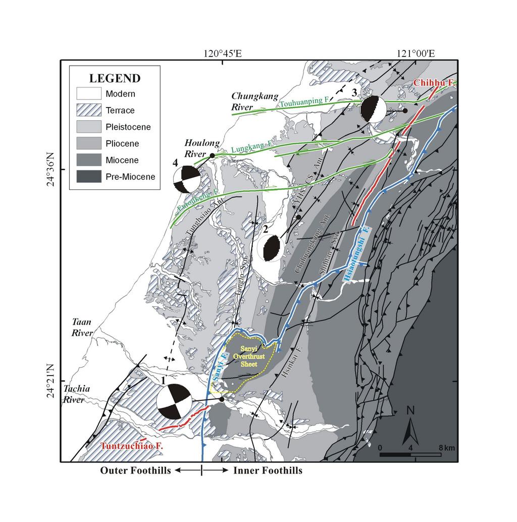
6 2. Regional backgrounds and the 1935 Hsinchu-Taichung Earthquake 2.1 Tectonic environments and local structural geology The mountainous island of Taiwan is created by the arc-continent collision that occurred along the active plate boundary between the Philippe Sea Plate and the Eurasian Plate (Ho, 1982; Fig. 1a). This oblique collision initiated at 3-6 Ma and has built up mountains southward from the north (Teng, 1990). The collision process is considered waning and replaced by post-collisional collapse in northern Taiwan, whereas in central and southern Taiwan the collision is still on-going (Shyu et al., 2005). Total shortening due to collision has been estimated up to km (Yue et al., 2005), among which km was taken up by slip on the thrust faults of the western foothills for the past 2 Ma (Simoes and Avouac, 2006). In response to the plate motion, thrust faults westward plowed up sedimentary strata deposited in the continental margin prior to the onset of the collision. On the western flank of the mountain ranges, imbricated thrust sheets and open folds distributed all the way to the Taiwan Strait (Suppe, 1985; Ho, 1988). Based on geological and neotectonic-related geomorphic features, Taiwan can be divided into several different domains in terms of the collision progress (Shyu et al, 2005). Our study area, the Miaoli domain in northwestern Taiwan, is defined as a mature collision neotectonic region (Fig. 1b). GPS records from 1990 to 1995 shows the motion of Miaoli relative to the stable Eurasian continental margin is mm/yr (Fig. 3) Triangulation data from 1914 to 1979 revealed a mean uplift rate of 4-8 mm/yr in Miaoli (Chen, 1981). In spite of this low strain rate, the occurrence of 1935 Hsinchu-Taichung earthquake indicates the seismic potential and possible future earthquake disasters in this region. Geologically, Miaoli consists of two major structural compartments (Chinese Petroleum Corporation, 1994; Lee, 2000; Fig. 4). The eastern one is the Inner 6
7 Foothills, characterized by densely-distributed reverse faults and folds or even recumbent folds and bounded by the east-dipping Sanyi-Hsiaotungshi Thrust System in the western margin (Yang et al., 2002; Huang et al., 2004; blue lines in Fig. 4). The western compartment is the Outer Foothills, dominated by continuous folds without major exposed thrust (Namson, 1981, 1983, 1984). The Chuhuangkeng Anticline, although slightly overridden by the Sanyi Overthrust Sheet in its south, is the most prominent feature among all structures (Meng, 1963; Hung and Wiltschko, 1993; Fig. 4). The Sanyi Overthrust Sheet is the southern segment of the Sanyi-Hsiaotungshi Thrust System. The name Sanyi Overthrust is defined by Meng (1963), who referred to the very low dip angle and shallow depth portion of the northern part of Sanyi Fault. The activity of this overthrust sheet may have incepted at around mid-pleistocene (c. 1 Ma), with total displacement of about 8-9 km and a long-term slip rate of mm/yr (Hung and Wiltschko, 1993). It is also considered less active during late Quaternary (Ota et al., 2006). Tightness of folds in the Outer Foothills gradually decreases westward to form opener and gentler anticlines. Besides these two divisions, three major E-W trending strike-slip faults, grouped as the Coastal Dextral Strike-slip Fault System, defines the northern boundary of the Miaoli Domain. From north to south, they are the Touhuanping Fault, the Lungkang Fault, and the Futoukeng Fault (green lines in Fig. 4). The Touhuanping Fault is a suspect active fault (Lin et al., 2000) with an almost vertical fault plane and flower structures in the shallow part (Yang et al., 1997). Terrace deformation along this fault indicates a south-dipping fault plane, with the upthrown side in the south. North and south of the Touhuanping Fault, there are two thrust faults (Fig. 4). According to seismic profiles, the thrust fault in the north (dashed line) is cut off by the Touhuanping Fault, whereas the one in 7
8 the south (solid line) merges with the Touhuanping Fault in the form of shallowed-up lateral ramp (Yang et al., 1997). These different structural styles make it difficult to define the actual amount of offset on the Touhuanping Fault. As for the Lungkang Fault and the Futoukeng Fault, they are identified as oblique-reverse faults with dip angles S, slightly gentler than that of the Touhuanping Fault (Huang et al., 1996; Huang et al., 1998). 2.2 Geomorphology The geomorphology of Miaoli domain is strongly controlled by the lithology and the structures (Fig. 3 & 4). In the northern part of the area east of the Sanyi-Hsiaotungshi Thrust System, densely aligned faults and tight folds developed within consolidated Oligocene-to-Miocene strata and formed the precipitous mountainous landscape. To the south, the folds become opener and therefore resulted in gentler topography. The mean elevation of the Inner Foothills is about 1500 m. West of the Sanyi-Hsiaotungshi Thrust System, the Chuhuangkeng Anticline is the clearest feature in the Outer Foothills. Strata on both sides of the anticline form a clear N-S elongated ellipsoid shape in map-view, and rocks as old as early Miocene are exposed. Hung and Wiltschko (1993) constructed a synchronous development model and suggested that the emplacement of the overriding Sanyi Overthrust Sheet and the uplift of the Chuhuangkeng Anticline in its footwall were around the same time. This hypothesis may explain why the current surficial height of the fold axis increases southward, with the highest point, c. 890 m a.s.l., in the hanging wall of the Sanyi Overthrust Sheet (Fig. 3). A tight Shihtan Syncline develops between the Chuhuangkeng Anticline and the Hsiaotungshi Fault. 8
9 Further west in the coastal area, the mean elevation decreases to less than 150 m. This area is composed of tablelands and hilly lands. Most of them are highly dissected, capped by lateritic terrace deposits and underlain by Pleistocene strata. Seaward warping of surfaces, especially for the terraces along the coast, is very common. It is also worthy of notice that the coastline in our study area is 5 km more protrudent than the coastline north of the Chungkang River. Its implication will be discussed later. In the southern part of the study area, the Houli Tableland stands between the Taan River and the Tachia River (Fig. 3). This large tableland contains several steps of river terraces developed northwestward in response to the migration and incision of the paleo-taan River (Lai et al., 2006). 2.3 The 1935 Hsinchu-Taichung Earthquake The mainshock (M=7.1; Hsu, 1971; no. 1 earthquake in Fig. 4) took place on 21 April Its epicenter was relocated at E, N (Cheng, 1995). Focal depth of the mainshock was determined as 3 km (Lin, 1987), which had long been considered too shallow in terms of the nucleation depth. Nevertheless, the poor quality of the old seismogram does not allow a more precise result. Fault plane solution of the mainshock was determined as (strike 67, dip 80, rake 180 ) (Chang, 1995). Three related surface ruptures were reported (Otuka, 1936; Fig. 4). In the south, the Tuntzuchiao Fault (TTCF) broke right across the southern corner of Houli Tableland. In the north, the Chihhu Fault (CHF) ruptured along the eastern flank of the tight Shihtan Syncline. The third surface rupture, the Shenchoshan Fault (not shown in maps), was observed along an anticlinal axis right east of the Hsiaotungshi Fault. The Shenchoshan Fault strikes subparallel 9
10 to the Chihhu Fault, but only a series of tension cracks and landslides were reported along its trace (Otuka, 1936). Therefore the Shenchoshan Fault is considered more likely a minor hinge-break fault (Huang et al, 2000) and will not be discussed in this study. Twelve seconds after the mainshock, a large aftershock (MW=6.8; Lin, 1987; no. 2 earthquake in Fig. 4) took place near the middle reach of the Houlong River in the north. This aftershock was not recorded in the original Taipei Meteorological Observatory catalog, because its signal was tangled with signals of the mainshock in the seismogram and could not be clearly distinguished (Lin, 1987). By using waveform modeling, this aftershock has been verified to initiate on the Chihhu Fault and have an approximate epicenter at E, N with focal depth of 8 km, fault strike of N23 E, dip of 43 NW and rake of 96 (Lin, 1987; Fig. 4). Also the 12 second lag time of this aftershock from the mainshock corresponded to most of the narration from the local people (Miyamura, 1985). The first cataloged aftershock took place 24 minutes after the main shock (Taipei Meteorological Observatory, 1936), at nearly the northern end of the Chihhu Fault with ML=6.0 (no.3 in Fig. 4). Again through waveform modeling, Lin (1987) discovered that rather than the fault plane of the Chihhu Fault, a secondary fault with depth of 2.5 km and located 10 km east of the Chihhu surface rupture fits better the observed waveform. Based on this result, we propose this aftershock is not related to major seismogenic structures and will not discuss it in our study. Three months later, another large aftershock (ML=6.2, no. 4 in Fig. 4) took place on 17 July near the river mouth of the Houlong River, causing severe structure damage and casualties (Taipei Meteorological Observatory, 1936). Cheng (1995) provided two sets of solution: (strike 255, dip 90, rake 30 ) or (strike 165, dip 60, rake 0 ), but no related surface rupture was ever reported. 10
11 We inferred the mainshock and the above-mentioned two large aftershocks (no. 2 & 4 in Fig. 4) as an earthquake series and further discussed their subsurface geometry and the linkage with each other. See Table 1 for detail parameters of these three earthquakes. 3. To determine the seismogenic structures of the earthquake series 3.1 The Tuntzuchiao Fault The surface rupture Tuntzuchiao Fault broke from the southern bank of the Taan River, and extended southwestward through the entire Houli Tableland, but became discontinuous when reaching the southern bank of the Tachia River (Fig. 5). Total rupture length was estimated between 12 km (Otuka, 1936) and 18 km, when counting the westernmost surficial cracks (Earthquake Research Institute, 1936). The average trend of the rupture was estimated to be N60 E, consistent with the fault plane solution (Cheng, 1995). Maximum dextral strike-slip offset was about 1.5 m, with varied amount of vertical offset along the rupture. The northwestern wall was upthrown 0.7 m in the northeast of Houli, yet in the south of Houli the southeastern wall was up m (Otuka, 1936; Fig. 5). In 2003, we re-investigated the Tuntzuchiao Fault in the field and could still recognize this heterogeneous uplift character. Shyu et al. (2005) applied the empirical relationship between moment magnitude of earthquakes and the rupture area (Wells and Coppersmith, 1994) to estimate the most probable moment magnitude of earthquakes on major seismic structures in Taiwan. In Miaoli, when rupture length of 20 km was assumed, the calculated moment magnitude of Tuntzuchiao Fault was merely about Mw 6.4. Twenty kilometer has already reached the upper limit of the observed rupture length, despite the fact that the recorded magnitude (M=7.1) is far greater than 11
12 Mw 6.4. However, if the rupture does not extend to surface everywhere along the fault, the actual ruptured part should be longer than the surface rupture. In map view, we noticed that the Tuntzuchiao surface rupture did not truncate the Sanyi Fault (Fig. 5). If the Tuntzuchiao Fault did extend under the Sanyi Overthrust Sheet and ruptured in its footwall, the rupture may have not truncated the hanging wall and been observed at the surface. In this case, the actual rupture length of the fault would be longer and the empirical moment magnitude will also be larger. To test this idea, we incorporated one published isochron map of the top of mid-miocene Talu Sandstone underneath the Sanyi Overthrust Sheet (Yang et al., 2001; Fig. 5). Since the Talu Sandstone is a key bed used for cross-tracing reflective seismic signals on different profiles in this region, its isochronal map is considered quite precise in subsurface stratigraphy. Miocene paleo-normal faults that ceased activity since late-pliocene were shown on this isochron map. One of these paleo-normal faults, extending from northeast to southwest under the Sanyi Overthrust Sheet, coincides with the eastern end of the Tuntzuchiao Fault. We named it as the Main Normal Fault (MNF). Seismic profile A-A provides the characteristics of this Main Normal Fault (Fig. 6): in the hanging wall (north side), strata are thicker but have been upthrown ~0.05 second, and the offset decreases upward till the fault tip dies out into the strata beneath the Sanyi Fault. This indicates structural inversion/reactivation along this paleo-normal fault. This normal fault reactivation could have initiated only very lately, because the offset is rather small and its fault tip has not yet disturbed the hanging wall of the Sanyi Fault. Since the Sanyi Fault is considered less active during the late Quaternary (Ota et al., 2006), we suspected that since then the shortening may have been localized along the paleo-normal faults in its footwall and resulted in 12
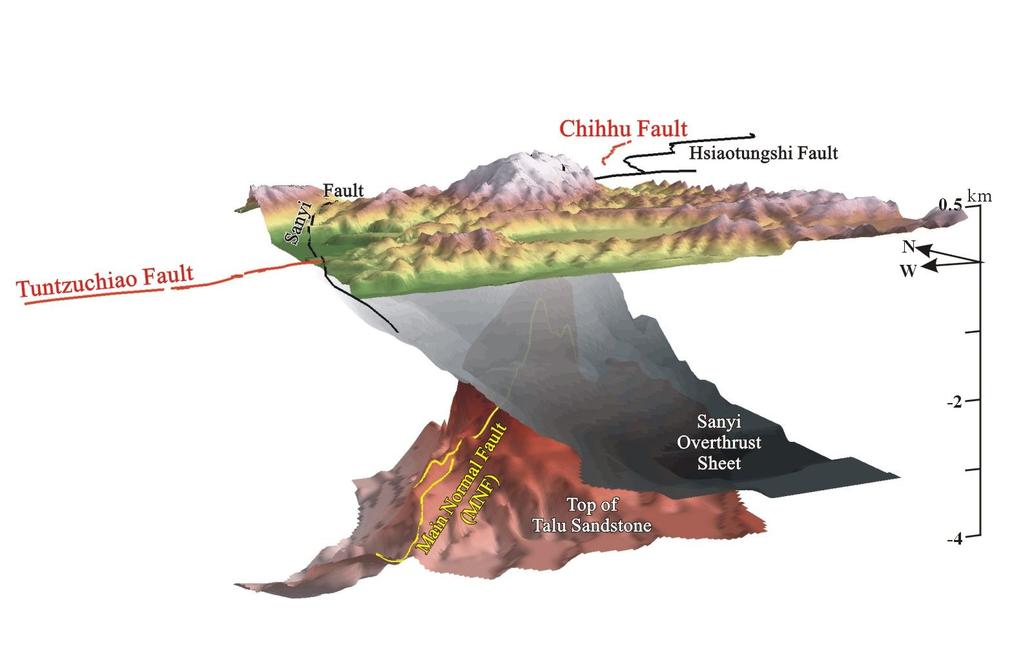
13 their reactivation as reverse faults. Another comparable feature in the same profile, called the Normal Fault 1 (NF1) by this study, still maintains the nature of a normal fault. Besides reverse faulting, if the Main Normal Fault is indeed the subsurface extension of the Tuntzuchiao Fault, there would be significant strike-slip movement along the fault. In map view (Fig. 5), there is a bend of strike on the Main Normal Fault close to the eastern end of the Tuntzuchiao Fault: the strike changes from N65 E to roughly N40 E. Such a bend on the fault strike forms an asperity on the fault plane. During the reactivation, especially when a normal fault is reactivated to be a strike-slip dominant fault, horizontal movement along strike may cause stress to accumulate at the bend and big earthquakes tend to nucleate from there. In order to provide a better visual model of subsurface structures, we further did a simple time-depth conversion of the isochron map by adopting a velocity function from a nearby CL-1 well as derived from sonic log (Fig. 5; Wu, 1983; Hu and Chiu, 1984) V(Z)= Z where Z is the depth and V is P-wave velocity. By solving this differential equation we got Z(t)= exp(0.353t) where t is the travel time. We then converted this isochron map into isodepth map. We also applied this method to the isochron map of the Sanyi Overthrust Sheet (Yang et al., 2001), and then put the two surfaces together with topography to make a 3D view. Figure 7 shows an image of the way the top of Talu Sandstone (pink surface) is folded by the Chuhuangkeng Anticline beneath the east-dipping Sanyi Overthrust Sheet (gray surface). Under this configuration, 13
14 the Main Normal Fault extends along the eastern flank of the Chuhuangkeng Anticline and seems to extend to the direction of the Chihhu Fault. It is possible that there is some structural link between the Main Normal Fault and the Chihhu Fault, but more subsurface data are needed to verify this hypothesis. 3.2 The Chihhu Fault The Chihhu Fault, trending N20 E on average, is located some 25 km to the north of the Tuntzuchiao Fault (Fig. 4). It extended from Shihtan northeastward and terminated north of the Chungkang River. Reported length varies, however, from c. 15 km (Otuka, 1936) to over 20 km (Earthquake Research Institute, 1936). Vertical offsets range from 0.3 to 3.0 m with west side up. This west-dipping Chihhu Fault has been considered as a back thrust, comparing to most of the major east-dipping thrust faults in western Taiwan (Fig. 1b), such as the Sanyi-Hsiaotungshi Thrust System (Hukunaga and Sato, 1938; Miyabe et al., 1938) and the Chelungpu Fault (Lin et al., 2000). As recent studies have pointed out (Chung, 1996; Kuo et al., 2004; Wu et al, 2004), back thrusts often play a major role in the western Foothills to accommodate the crustal shortening and to generate earthquakes. Judging from the amount of offset and the magnitude of the related aftershock, the Chihhu Fault could be one example of these major back thrusts. How deep the plane of the Chihhu Fault goes has long been in debate (Tang, 1969; Bonilla, 1975). In field observations, both hanging wall and footwall have the same stratigraphic unit, the late Miocene Shangfuchi Sandstone. This implies the total offset of the Chihhu Fault is rather small. Furthermore, no related gouge or other fault rock has ever been reported from any of the wells around the fault. These facts indicate that the fault may be just a bedding-plane 14
15 slip fault or a fold-related flexural-slip fault only in a shallow depth and of less importance. Therefore, when trying to estimate the most probable moment magnitude on this fault, Shyu et al. (2005) used a shallow depth (5 km) with the empirical regression formula (Wells and Coppersmith, 1994). Their calculated moment magnitude of the Chihhu Fault is Mw 6.1. However, if we consider the maximum uplift of 3 m and an affected area of 12 km wide and 30 km long west of the Chihhu Fault in 1935, a Mw. 6.1 for the earthquake may seem too small. To solve this puzzle, we collected 1501 earthquake records from 1973 to 2003 in this area and relocated them by means of Hypo-Double-Difference (Waldhauser and Ellsworth, 2000). Although the relocated seismic distribution was quite sparse and scattered west of the Chihhu Fault (circles in Fig. 8a), there appears to be a boundary separating the seismic eastern and aseismic western district (gray dashed line in Fig. 8b) in the E-W profile across the area. This boundary can be traced down to 10 km in depth. Focal mechanism of the few ML > 4 earthquakes also shows thrusting movement along this boundary. Since recent earthquakes show no clustered pattern of the Chihhu Fault, we turned to seek for older seismic records instead. After the main shock on 21 April 1935, dense and intense aftershocks occurred till the end of that year (Taipei Meteorological Observatory, 1936), but most of them were recorded without detailed information. Fortunately a temporary micro-earthquake array was set up and had collected data from August to December in 1935 (stations shown in Fig. 8a; Nasu, 1936). In total, 55 earthquakes with P-S travel time difference, maximum acceleration and a rough estimation of depth were recorded. Although the travel time precision was merely two digits after the decimal point (in second), these data are the only one set that was recorded not long after the mainshock and capable of a better relocation precision (the mean RMS value in Z direction 15
16 after our relocation is 1.17 km). For details of the relocation method, please refer to Appendix A. Relocated earthquakes are put together to compare with recent earthquakes in Fig. 8a (red stars). Because of the limited quality of data, the relocated earthquakes do not show very beautiful cluster. However, most of the earthquakes are surrounding the boundary plane that separates the currently seismic eastern and aseismic western district, as defined by the earthquakes from 1973 to 2003 (Fig. 8b). We therefore interpret the Chihhu Fault as a deeply-seated back thrust, rooting as deep as 7-10 km. 3.3 Seismogenic structure of the 17 July aftershock (ML=6.2) As mentioned in section 2.3, no surface rupture was observed to be related to this aftershock. The fault plane solution is either a N15 W striking sinistral strike-slip fault with dip of 60 W or a N75 E striking dextral strike-slip fault with almost vertical fault plane (Cheng, 1995). We went through all field records of railway and building destructions, and found a picture of mild dextral rail-track bending across the E-W trending Chungkang River (see Fig. 4 for river location) as well as several descriptions of en echelon wall cracks (Earthquake Research Institute, 1936). We think these are lines of evidence to represent possible surface deformations related to this aftershock. With this assumption, the N15 W sinistral strike-slip fault is less likely to be the fault plane solution of this aftershock. If the N75 E dextral strike-slip fault plane solution is correct, we have three candidates: the Touhuanping Fault, the Lungkang Fault and the Futoukeng Fault (Fig. 4). Whereas these three all dip southward, the Lungkang Fault and the Futoukeng Fault have downward decreasing fault dips, and the Touhuanping Fault has an almost vertical fault plane (Huang et al., 1996; Huang 16
17 et al., 1998; Yang et al., 1997). Considering the over 20 km deep focal depth of this aftershock and the surficial location of the destructions, we believe the Touhuanping Fault is most likely to be the seismogenic structure. However, because no surface rupture was ever reported, slip on the fault plane might be small and decrease upward or might have scattered into the flower structures in the shallow part of the fault. For the geometric dimension of the Touhuanping Fault and the other two surface ruptures mentioned in 3.1 and 3.2, refer to Table Geodetic data and modeling of the 1935 earthquake Several different geodetic datasets exist before and after the 1935 earthquake. Therefore, we attempt to test our proposed seismogenic structures of the mainshock and aftershocks by comparing the modeling results and the geodetic records. The main geodetic datasets employed are triangulation and leveling measurements. 4.1 Triangulation measurements The triangulation measurements taken in 1917 and 1936 covered stations of the first, second and third class triangulation benchmarks distributed from Hsinchu to Taichung (Military Land Survey, 1937; Fig. 9a). The benchmark class is distinguished by the length between benchmarks (i.e., the side length of triangles) and the quality of station location. In Taiwan, the first class has the longest side length (45 km in average) among the three classes and the best field of vision, mostly on hilltops. The time span covered 18 years before the 1935 earthquake, the year of the earthquake and one year after the event, and therefore the information revealed by this dataset is quite complex. Observation 17
18 errors of the dataset are listed in Table 3. We eliminated stations with inconsistent deformation patterns that may represent local effects such as sliding of hill slopes. In total, only 52 of the total 60 triangulation benchmarks were used in our modeling (Fig. 9a; eliminated stations not shown). Furthermore, only horizontal vectors were used in our modeling, since vertical components contain high spatial heterogeneity and complexity that make it very difficult to fit in our model. However, we can still observe some general patterns from the vertical vectors. We will discuss those general patterns together with the leveling data later, in section Modeling method Because of the limited resolution in the dataset, we believe analytical solution of elastic dislocation theory by assigning simple fault plane models would be appropriate. We adopted the inversion FORTRAN code by Wu et al. (2006) based on the subroutines of Okada (1992). In addition, we tried to use a stepwise emplacement of fault planes into the modeling, so that the effect of each single fault plane could be specified. Starting from the Tuntzuchiao Fault-Main Normal Fault, we step by step put in the Chihhu Fault and then the Touhuanping Fault. Through trial and error, we realized some of the fault planes need to be dissected to represent different segments, whereas some other planes than the four in Table 2 are necessary to satisfy the overall deformation pattern. 4.3 Modeling result Figure 9b-f show the results of the stepwise modeling. In step 1 (Fig. 9b), only the Tuntzuchiao Fault and the Main Normal Fault were involved. The 18
19 strike of the fault changed from N63 E to N43 E. Within this step, except for the vectors around the Tuntzuchiao Fault, none of the other vectors were properly fit. In step 2, we then put in the Chihhu Fault (Fig. 9c). Not only did the vectors around the Chihhu Fault get fit after this step, but some vectors around the Tuntzuchiao Fault also got better constrained in terms of magnitude. However, for the three stations between the Main Normal Fault and the Chihhu Fault (MNB, YPS and SYF), fitting was rather bad. It seems that one more fault plane in the gap area was necessary. During step 3 (Fig. 9d),we therefore added one more plane, whose location, strike and depth were in between those of the Main Normal Fault and of the Chihhu Fault, with its dip to the west to represent a back thrust. The result showed an overall improvement of fitting along all fault planes, in particular for the vectors at MNB, YPS and SYF. RMS values also decreased significantly from in step 1 to in step 3 (Table 4). In step 4 (Fig. 9e), we included the Touhuanping Fault. By comparing Fig. 9d and Fig. 9e, we could tell that only slightly better fit of vectors in the north (GXI, SDS and GSL) were obtained after involving this one more plane. After this step, we found an area of certain discrepancies between the observed and modeled vectors between the coast and the proposed seismogenic faults. The most notable discrepancies were present in the stations along the coast, such as PTD, GPU and WLI. Therefore, we decided to put two more faults in the offshore area (the dissection of one fault into two was through trial and error) in stage 5, and some vectors in this area got better fit (Fig. 9f). However, from step 4 to step 5, improvement of fitting was limited; the RMS values only decreased from to Table 4 lists the solution of all seven planes (refer to Fig 9f for plane id). Plane A represents the surface rupture of the Tuntzuchiao Fault. The strike slip 19
20 and dip slip on this plane is 1 m and 0.83 m, respectively, indicating a dextral-slip dominated, down-dip movement. Plane B represents the subsurface Main Normal Fault under the Sanyi Overthrust Sheet. The slip pattern becomes dextral strike slip of 2.6 m and up-dip slip of 0.95 m, which is consistent with the fact that the recorded largest uplift in the south occurred at station KTS rather than along the Tuntzuchiao Fault (Fig. 10a). As vertical components along the Tuntzuchiao Fault itself are not homogeneous (Fig. 10a), the down-dip slip of plane A and up-dip slip of plane B could be the result of this heterogeneity. Plane C and D represent the surface rupture Chihhu Fault and a proposed linkage fault. Both of them have a small left lateral movement and an up-dip slip of nearly 2 m. Plane E represents the Touhuanping Fault; plane F1 and F2 represent the north and south segments of a proposed offshore fault. All three faults are right lateral with down-dip movement. We will discuss their meaning later. 4.4 Vertical deformation pattern during different periods Based upon two reasons, we decided to treat the vertical deformation pattern separately: First, the complexity of the triangulation dataset made it difficult to fit during modeling. Second, the existence of other different datasets that cover different time span enables better temporal analysis than the horizontal components. Besides the triangulation data, we also have (1) the 3rd island-wide triangulation measurement (around ; Combined Logistics Command, 1980) and (2) leveling measurements done in 1918, 1936 (Military Land Survey, 1937) and 1979 (Water Resources Agency, 1985). These datasets have been published for a long time, but have never been integrated and analyzed 20
21 together. We divide our data into two time spans: and , assuming that one or two years of different time duration among our datasets would not yield significant difference. The former group contains signals of the 1935 Hsinchu-Taichung earthquake itself, as well as signals before and after the earthquake; the later group recorded basically the post-seismic signals. Since it is impossible to separate the pure coseismic components from the first group, we assume that the coseismic signals were much more significant and had overwhelmed the non-coseismic signals. In the later sections, we will therefore refer to the group as the coseismic group. Integrated and interpolated vertical deformation of this group is shown in Figure 10a. As mentioned before, the pattern is quite complicated, but basically the uplift zones distribute in the hanging walls of the Sanyi Overthrust Sheet and the Chihhu Fault, whereas a wide subsidence zone appears from E to the coastline, with a maximum recorded subsidence of 0.55m. As for the second group (Figure 10b), it shows a different pattern, almost but not fully inverse to the pattern of the first group. Particularly, the original uplift zone near the southern end of the Chihhu Fault turns to subsidence, and the coastal subsidence zone turns to uplift. We will discuss the geological meaning of this phenomenon in the next section. 5. Seismic phase and structural complex revealed by the 1935 Hsinchu-Taichung Earthquake In this section, we discuss the linkage among the earthquake series, the surface deformation and the seismogenic structure complex. Based on the stepwise modeling results and the geodetic data presented above, three phases, from coseismic to post-seismic, can be identified. 21
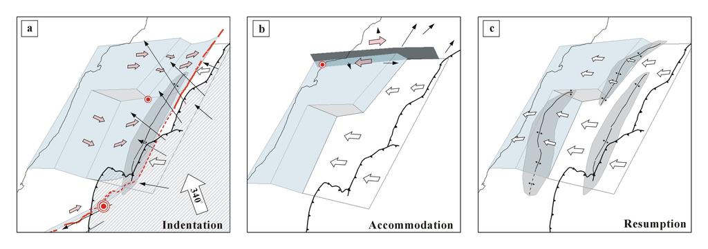
22 Phase I: Indentation During Phase I, the 1935 mainshock took place on the Tuntzuchiao-Main Normal Fault system where the fault strike changes and the stress accumulated. Twelve seconds later a major aftershock took place on the Chihhu Fault. After examining the deformation pattern carefully, we observed that vectors east of the Chihhu Fault moved northwestward; vectors southeast of the Tuntzuchiao Fault moved southwestward; vectors in between changed their movement direction gradually from NW to SW (Fig. 9a, 11a). All these vectors seemed to form a radiating pattern in the block east of the Tuntzuchiao-Chihhu Fault system. We interpret this phase as the indentation phase, in which the Inner Foothill behaved as a local rigid buttress to push material in the west along the regional detachment. In order to illustrate our idea, we tried to construct an E-W geologic cross-section with kink method (Fig. 12a; modified after Hung and Wiltschko, 1993). In this cross-section, right west of the Inner Foothills, there are the Pakuali Anticline, the Chuhuangkeng Anticline and the Yungheshan-Chinshui (YHS-CS) Anticline from east to west. The Pakuali and the Chuhuangkeng Anticlines are both very tightly and sub-symmetrically folded, with limb angles of Among these two, the Chuhuangkeng Anticline is particularly well-developed with a fairly symmetric shape in section view and a lenticular shape in map view (Fig. 4). Compared with this, the Yungheshan-Chinshui Anticline is more gently folded with limb dips up to 40 in its eastern flank. Furthermore, fold types of these three anticlines are not the same: the Pakuali and Chuhuangkeng Anticlines are detachment folds, whereas the Yungheshan-Chinshui Anticline is a detachment fold translated over a ramp. The major difference between Hung and Wiltschko (1993) and our interpretation 22
23 is the existence of the Chihhu Fault. After integrating the earthquake relocation result shown in Fig. 8, we put the Chihhu Fault into the cross-section: it initiates from the ramp top under the Yungheshan-Chinshui Anticline, cuts through the east limb of the Chuhuangkeng Anticline, and surfaces along the bedding of the Shangfuchi Sandstone. The ramp on the detachment and the plane of the Chihhu Fault together form a wedge on the detachment and thereby the Chihhu Fault is interpreted as a wedge-back thrust. As for the Tuntzuchiao-Main Normal Fault, both of them are interpreted as reactivated strike-slip faults from pre-existing Miocene normal faults. The total slip on the Tuntzuchiao Fault and the Main Normal Fault is 1.3 and 2.8 m, respectively (Table 4). Together with the 21-km and 10-km fault lengths and a 15-km width, our calculated moment magnitude for the mainshock reaches Mw 6.9. Structurally, this reactivated fault system changes strike from N60 E to N40 E, and extends northward along the east limb of the Chuhuangkeng Anticline (Fig. 7). Since the Chuhuangkeng Anticline is already tightly folded, this strike-slip system would be more likely to move than the anticline. Although Yue et al. (2005) suggested that the Tuntzuchiao Fault is a fault-bend-fold fracture related to the surface trace of an anticlinal axial surface, our analysis indicates that it may be better interpreted as a reactivated normal fault. As for the connecting plane between the Tuntzuchiao-Main Normal Fault and the Chihhu Fault (Fig. 9d), we believe that this fault plane should have existed despite the absence of surface ruptures. The solution of the best fit plane yields (φ=208, δ=60, λ=-112 ), with an up-dip slip up to 1.86 m (Table 4), which is very similar to the solution of the Chihhu Fault (φ=203, δ=45, λ=-96 and up-dip slip of 1.97m). We suggest that this fault plane is the southward 23
24 extension of the Chihhu Fault, as shown in the structural cross-section in Figure 12b. Combining all the above information, we suggest that this phase started from the local rigid buttress, i.e. the Inner Foothill outlined by the Sanyi-Hsiaotungshi Thrust System and composed of Oligocene-Miocene competent rocks, pushed along the detachment. In response to this indentation from the east, the lenticular-shaped Chuhuangkeng Anticline stood as a strong obstacle in this region. As a result, the weaker part in the southeast and northeast broke through, including the reactivated Tuntzuchiao-Main Normal Fault and the wedge-back thrust Chihhu Fault. An unsurfaced linkage west-dipping fault was then formed in between (Fig. 11a). Phase II: Accommodation During Phase II, three months after the mainshock, the 17 July aftershock took place at the river mouth of the Houlong River (Fig. 2), yet no surface rupture was reported. As mentioned in section 3.3, some rail-track bending and building cracks were observed near the Touhuanping Fault trace, and hence we believe it was the seismogenic structure related to this aftershock. The triangulation data also shows higher eastward movement north of the Touhuanping Fault than the area south of the fault. This implies a dextral slip on the fault (Fig. 9e, 11b). We interpret this short-term transition stage as the accommodation phase, during which the Outer Foothills was trying to accommodate the shortening induced by the indentation of the Inner Foothills (Fig. 11b). Through the movement of the Touhuanping Fault, the block encircled by the Phase I faults and the Touhuanping Fault moved westward relative to the block north of the Touhuanping Fault (the Hsinchu Domain). It is therefore consistent with what 24
25 was proposed by Shyu et al. (2005), that the Miaoli Domain and Hsinchu Domain are independent in terms of seismogenic structures and seismic hazards, separated by the Touhuanping Fault as the boundary fault. Hence, the protrudent coastline of the Miaoli area, compared with the coastline to the north, is probably not a geographic coincidence but the result of the long-term activity on the Touhuanping Fault. Phase III: Resumption In the last stage of our model, we involved two more planes along the coast, plane F1 and F2 (Fig. 9f). The purpose was to fit the vectors along the coast, and the solutions of these two fault planes (low angle faults with down-dip and dextral movement; Table 4) were also consistent with the coastal subsidence east of E (Fig. 10a). Nevertheless, the existence of such normal faults is not supported by any geologic data we have in hand. The solution was not unique either: through trial and error, we found any two planes along the coast with different lengths, depths and dips could yield similar result as Fig. 9f. Rather than inventing coastal normal faults, we decided to search for other solutions. We sampled twenty NW-SE profiles on the vertical deformation (dz) maps, ten along profile C and ten along profile D, to compare with the geologic cross sections (Fig. 10, 12). In Figure 12a, the dz (black lines) reaches a maximum uplift of ~0.5 m right to the west of the Chihhu Fault, gradually decreases to zero and gently fluctuates between to 0.1 m across the Yungheshan-Chinshui Anticline. In Figure 12b, the dz (black lines) also reaches a maximum uplift of ~0.4 m over the Chuhuangkeng Anticline (above the proposed southward extension of the Chihhu Fault), decreases westward and turns to as negative as -0.8 m over the Tunghsiao Anticline. In map view (Fig. 25
26 10a), we found that the coastal subsidence region almost coincides with the location of the Tunghsiao Anticline. This pattern seems abnormal, since the maximum subsidence appears over an anticlinal axis instead of a syncline. However, such an unusual pattern may be explained by the subsurface geometry of the seismogenic structures. During a reverse-faulting earthquake, the areas farther in the hanging wall often experience coseismic subsidence due to the mass balance of materials moving along the fault surface, especially when the earthquake occurs along a detachment ramp. One example of such hinterland subsidence phenomenon in Taiwan is the coseismic subsidence of the Puli basin during the 1999 Chi-Chi earthquake. During the earthquake, m vertical uplifts were observed along the surface rupture of the Chelungpu Fault, whereas the Puli basin, in the hanging wall 20 km east of the surface rupture, experienced a maximum subsidence of 0.6 m (Yu et al., 2001). Chen et al. (2001) proposed that the point where the coseismic subsidence changes to coseismic uplift may represent the point where the detachment ramps up. During the 1935 earthquake, the coastal subsidence may as well be a coseismic hinterland subsidence in the hanging wall west of the surface rupture. In the northern part of the area along profile C, the detachment west of the ramp is flatter and deeper, thus the coseismic dz has a smaller relief, and the hinterland subsidence is not clear. Under this interpretation, the two extra planes F1 and F2 are no longer needed to fit the coastal subsidence. It is possible that most of the vertical movement pattern was caused by coseismic deformation and controlled by the configuration of the regional detachment. We demonstrate how the regional detachment may look like in Figure 11a, in which a lateral ramp sits in the middle. North of this lateral ramp, the detachment ramp under the Yungheshan-Chinshui 26
27 Anticline is narrower; in the south the detachment ramp under the Tunghsiao Anticline is broader. Compared with the coseismic deformation, the post-seismic ( ) dz (gray lines) along profile C (Fig. 12a) shows a clear antiform across the Chuhuangkeng and Yungheshan-Chinshui Anticlines, with most values greater than zero, implying a regional uplifting. Along profile D (Fig. 12b), the post-seismic dz (gray lines) also shows two peaks over the two anticlines and a trough in between. It seems during this period, the vertical deformation followed the structural characteristics in the first order, which might result from the westward aseismic slip on the regional detachment. We interpret this phase ( ) as an elastic resumption phase (Fig. 11c), which means most structures in Miaoli resumed their inter-seismic deformation pattern by means of folding, and stress and strain started to cumulate again over the detachment ramp. Conclusion Our analysis indicate that the seismogenic structures of the 1935 Hsinchu-Taichung earthquake include the two surface ruptures Tuntzuchiao Fault and the Chihhu Fault, the Main Normal Fault, and the Touhuanping Fault. The subsurface Main Normal Fault is the un-surfaced part of the Tuntzuchiao Fault. It used to be a normal fault and was reactivated to become a strike-slip fault probably during the late Quaternary The Chihhu Fault is a major back thrust and may extend southward under the Inner Foothills, forming a linkage to the Tuntzuchiao-Main Normal Fault system in the south. The Touhuanping Fault may be responsible for the aftershock three months after the mainshock. According to our elastic dislocation modeling and the reprocessed geodetic 27
28 data, three seismic phases can be identified: indentation, accommodation and resumption. During the indentation phase, the Inner Foothills formed a buttress in the east that pushed westward, resulting in the mainshock, a major aftershock, as well as the two surface ruptures. Geodetic data also revealed a horizontal radiating pattern east of the major seismogenic structures. Coseismic subsidence along the coast may result from the hinterland subsidence in the hanging wall (west) of the Chihhu Fault. During the accommodation phase, marked by the 17 July aftershock, the Touhuanping Fault was triggered to move. It accommodated the different velocities between the Miaoli Domain and the Hsinchu Domain in the north. During the resumption phase ( ), major structures in the Miaoli Domain resumed their inter-seismic deformation pattern by means of aseismic folding. 28
29 Appendix A: Relocation of aftershocks recorded from August to December, 1935 In order to relocate the aftershocks recorded by Nasu (1936), we adopted the basic inversion model of D = G * M and its general solution of M = [ G T G ] -1 G T D where D is the distance matrix, G is the station coordinate matrix and M is the source coordinate matrix needed to be solved. To satisfy the model, the distance matrix D should be calculated from the P-S travel time difference in the record, so we used VELEST v. 3.3 (Kissling et al., 1994) along with the 1501 earthquakes from 1973 to 2003 to evaluate different velocity models (Lin et al., 1989; Chen and Shin, 1998; Lee, 1998; Sheng, 1999). Based on the results of minimum RMS misfit, we chose the Taiwan 1-D P-wave velocity model (Chen and Shin, 1998; for RMS misfit see Fig. A1a), but modified it to fit the Miaoli area (Fig. A1b). S-wave velocity was assumed to be Vp/ 3. Refined travel time curve is shown in Fig. A1c. 29
30 Reference Bonilla, M.-G. (1975), A review of recently active faults in Taiwan, U. S. Geol. Surv. Open-file Rep., 75-41, 58 pp., Menlo Park, Calif. Chen, H.-F. (1981), Present-day crustal uplift and subsidence in Taiwan (in Chinese), M.S. thesis, 85 pp., Chinese Culture Univ., Taipei, Taiwan. Chen, W.-S., et al. (2001), 1999 Chi-Chi Earthquake: a case study on the role of thrust-ramp structures for generating earthquakes, Bull. Seismol. Soc. Am., 91, Chen, Y.-L. and T.-C. Shin (1998), Study on the Earthquake Location of 3-D Velocity Structure in the Taiwan Area, Meteorol. Bull., 42(2), Cheng, S.-N. (1995), The study of stress distribution in and around Taiwan (in Chinese with English abstract), Ph.D. thesis, 215 pp., Natl. Central Univ., Chungli, Taiwan. Chinese Petroleum Corporation (1994), The geological map of Miaoli, scale 1:100,000, Taiwan Pet. Explor. Div., Miaoli, Taiwan. Chung, K.-T. (1996), Foothills structure in the Miaoli area (in Chinese with English abstract), M.S. thesis, 108 pp., Natl. Central Univ., Chungli, Taiwan. Combined Logistics Command (1980), Triangulation Measurement Result of Republic of China (in Chinese), 2674 pp., Min. of Nat. Defense, Taiwan, 2 Volumes. 30
31 Earthquake Research Institute (1936), Field Investigation (in Japanese with English abstract), Spec. Bull. Earthquake Res. Inst. Tokyo. Imp. Univ., 3, suppl., Ho, C.-S. (1982), Tectonic evolution of Taiwan-Explanatory text of the tectonic map of Taiwan (in Chinese), 126 pp., Min. of Economic Affairs, Taipei, Taiwan. Ho, C.-S. (1988), An Introduction to the Geology of Taiwan, Explanatory Text of the Geologic Map of Taiwan, 2nd ed., 192 pp., Cent. Geol. Surv., Taipei, Taiwan.. Hsu, M.-T. (1971), Seismicity of Taiwan and some related problems, Bull. Int. Ins. Seismol. Earthquake Eng., 8, Hu, C.-C. and H.-T. Chiu (1984), Deep structure of the Cholan area, northwestern Taiwan, Pet. Geol. Taiwan, 25, Huang, B.-S. and Y.-T. Yeh (1992), Source geometry and slip distribution of the April 21, 1935 Hsinchu-Taichung, Taiwan earthquake, Tectonophysics, 210, Huang, S.-T., H.-C. Shen, H.C., I.-C. Torng and W.-R. Chi (1996), Structural Inversion in Relation to Hydrocarbon Accumulation: The Offshore and Coastal Area of Miaoli-Hsinchu (in Chinese), Bull. Explor. Prod. Res., 19, Huang, S.-T., H.-C. Shen, S.-H. Hsu, W.-R. Chi and T.-S. Chen (1998), Deformation Front of Thrusting Tectonics of Penglai Orogeny and Hydrocarbon Accumulation: Coastal Area, Miaoli (in Chinese), Bull. Explor. Prod. Res., 21, Huang, S.-T., K.-M. Yang, J.-H. Hung, K.-A. Lin, M.-S. Wu, J.-C. Wu, H.-H. Ting, W.-W. 31
32 Mai, H.-H. Hsu and J.-H. Yang (2004), The structural characteristics of the inner Foothills in Miaoli the Shihtoushan structure, paper presented at 2004 Joint Geosciences assembly - Land use and environment changes: regional and global perspective, Taiwan. Huang, W.-C., C.-W. Lin, Y.-H. Lin, W.-Y. Wu, C.-Y. Chen and S.-Y. Liu (2000), Survey report of active faults - the Shihtan and Shenchoshan Fault (in Chinese). Cent. Geol. Surv. Project Rep.. Taiwan ( Hukunaga, M. and M. Sato (1938), Crustal deformations in central Taiwan, part 1, Bull Earthquake Res. Ins., 16, Hung, J.-H. and D. V. Wiltschko (1993), Structure and kinematics of arcuate thrust faults in the Miaoli-Cholan area of western Taiwan, Pet. Geol Taiwan, 28, Kissling, E., W. L. Ellsworth, D. Eberhart-Phillips and U. Kradolfer (1994), Initial reference models in local earthquake tomography, J. Geophys. Res., 99, 19,635-19,646. Kuo Y.-T., Y.-G. Chen, Y.-M. Wu, H.-L. Chen, C.-H. Chang, R.-Y. Chen, P.-W. Lo., K.-E. Ching and J-C. Lee (2004), Seismogenic structures deduced from 3D spatial analysis for 1999 ML 6.4 Chiayi earthquake sequences, EOS, Trans., Am. Geophys. Uni., 85(47), Fall Meet. Suppl., Abstract T11D
33 Lai, K.-Y., Y.-G. Chen, J.-H. Hung and Y.-w. Chen (2006), Surface deformation related to kink-folding above an active fault: evidence from geomorphic features and co-seismic slips, Quatern. Int., 147, Lee, H.-C. (1998), The S-wave velocity structure under center-west Taiwan by strong ground motion waveform modeling (in Chinese with English abstract), M.S. thesis, 138 pp., Natl. Central Univ., Chungli, Taiwan. Lee, J.-F. (2000), Explanatory text of the geologic map of Taiwan, scale 1:50,000, sheet 18, Tungshih (in Chinese), Cent. Geol. Surv., Taipei, Taiwan. Lin, C.-H., Y.-H. Yeh and S.W. Roecker (1989), Seismic velocity structures in the Sanyi-Fengyuan area, central Taiwan. Proc. Geol. Soc. China, 32(1), Lin, C.-W., H.-C. Chang, S.-T. Lu, T.-S. Shih and W.-J. Huang (2000), An introduction to the active faults of Taiwan, Explanatory text of the active fault map of Taiwan (in Chinese with English abstract), 2nd ed., Spec. Publ., 13, 122 pp., Cent. Geol., Surv., Taipei, Taiwan. Lin, D.-H. (1987), Mechanism of the Hsinchu-Taichung, Taiwan, earthquake of 1935 (in Chinese with English abstract), M.S. thesis, 88 pp., Natl. Cent. Univ., Chungli, Taiwan. Meng, C.-Y. (1963), The San-I Overthrust, Mr H,H. Ling s 70th Birthday Jubilee Volume, Pet. Geol. Taiwan, 2,
34 Military Land Survey (1937), Report of revision surveys of 1st, 2nd and 3rd order triangulations and 1st order precise leveling in the Taiwan earthquake zone (in Japanese), 8 pp. Miyabe, N., M. Hukunaga and M. Sato (1938), Crustal deformations in central Taiwan, part 2, Bull. Earthquake Res. Ins., 16, Miyamura, S. (1985), The Hsinchu-Taichung, Taiwan, Earthquake of April 20, 1935, Commemorative Symposium of 50th Anniversary of the 1935 Hsinchu-Taichung Earthquake, Taiwan, Namson, J. (1981), Structure of the western Foothills Belt, Miaoli-Hsinchu area, Taiwan: (I) southern part, Petr. Geol. Taiwan, 18, Namson, J. (1983), Structure of the western Foothills Belt, Miaoli-Hsinchu area, Taiwan: (II) central part, Pet Geol Taiwan, 19, Namson, J. (1984), Structure of the western Foothills Belt, Miaoli-Hsinchu area, Taiwan: (III) northern part, Pet. Geol. Taiwan, 20, Nasu, N. (1936), The after-shocks of the Formosa Earthquake of 1935 (in Japanese with English abstract), Spec. Bull. Earthquake Res. Inst. Tokyo. Imp. Univ., 3, suppl., Okada, Y. (1992), Internal deformation due to shear and tensile faults in a half-space. Bull.Seismol. Soc. Am., 82,
35 Ota, Y., Y. N. Lin, Y.-G. Chen, H.-C. Chang and J.-H. Hung (2006), The Tunglo Active Fault System as deduced from deformed terraces, central Taiwan, Tectonophysics, 417, Otuka, Y. (1936), The earthquake of central Taiwan (Formosa), April 21, 1935, and earthquake faults (in Japanese with English abstract), Bull. Earthquake Res. Inst. Tokyo. Imp. Univ., 3, suppl., Sella, G. F., T. H. Dixon, and A. Mao (2002), REVEL: A model for recent plate veolocities from space geodesy, J. Geophys. Res., 107(B4), 2081, doi: /2000JB Sheng, C.-H. (1999), The study of the velocity structure of the northwestern linear seismic zone by ray tracing (in Chinese with English abstract), M.S. thesis, 103 pp., Natl. Cent. Univ., Chungli, Taiwan. Sheu, H.-C. (1985), Using triangulation measurement results to analyze the crustal deformation and structure of eastern Taiwan (in Chinese), J. Surv. Eng., 27(1), Sheu, H.-C., M. Kosuga and H. Sato (1982), Mechanism and fault model of the Hsinchu-Taichung (Taiwan) earthquake of 1935 (in Japanese), Zisin. 2(35), Shyu, J. B. H., K. Sieh, Y.-G. Chen and C.-S. Liu (2005), Neotectonic architecture of Taiwan and its implications for future large earthquakes, J. Geophys. Res., 110, 35
36 B08402, doi: /2004jb Simoes, M. and J. P. Avouac (2006), Investigating the kinematics of mountain building in Taiwan from the spatiotemporal evolution of the foreland basin and western foothills, J. Geophys. Res., 111, B10401, doi: /2005jb Suppe, J. (1985), Principles of structural geology, 537 pp., Prentice-Hall Inc., Englewood Cliffs, New Jersey. Suppe,J., C.-H. Hu and Y.-G. Chen (1985), Present-day stress directions in western Taiwan inferred from borehole elongation, Pet. Geol. Taiwan, 21, Taipei Meteorological Observatory (1936), The report of the April 21 st, 1935, Hsinchu-Taichung Earthquake (in Japanese), 160 pp., Taipei Meteorological Observatory. Teng, L. S. (1990), Geotectonic evolution of Late Cenozoic arc- continent collision in Taiwan, Tectonophysics, 183, Tang, C.-H. (1969), Photogeological interpretation of the Miaoli area, Taiwan, with special reference to its geologic structures, Proc. Geol. Soc. China, 12, Waldhauser, F. and W. Ellsworth (2000), A double-difference earthquake location algorithm: method and application to the Northern Hayward Fault, California, Bull. Seismol. Soc. Am., 90, Water Resources Agency (1985), Inspection result of first order leveling points, 308 pp., 36
37 Min. of Economic Affairs, Taipei, Taiwan. Wu, M.-H. (1983), Time-depth charts for the HL-1 and CLN-1 wells, Unpublished CPC file. Wu, J.-C., W.-W. Mei, Y.-L. Chang, K.-M. Yang, S.-T. Huang, M.-H. Wang and C.-C. Tsai (2004), The paleostructural evolution and backstripping analysis in the northwestern Taiwan (in Chinese), paper presented at 2004 Joint Geosciences assembly - Land use and environment changes: regional and global perspective, Taiwan. Wu, Y.-M., Y.-G. Chen, T.-C. Shin, H. Kuochen, C.-S. Hou, J.-C. Hu, C.-H. Chang, C. H., C. F. Wu and Teng, T.-L. (2006), Coseismic versus interseismic ground deformations, fault rupture inversion and segmentation revealed by 2003 Mw 6.8 Chengkung earthquake in eastern Taiwan, Geophys. Res. Lett., 33, L02312, doi: /2005gl Yang, K.-M., H.-H. Ting, J.-C. Wu and W.-R. Chi (1997), Geological model for complex structures and its implications for hydrocarbon exploration in northwestern Taiwan, Pet. Geol. Taiwan, 31, Yang, K.-M., J.-C. Wu, H.-H. Ting, W.-W. Mei, C.-T. Tsai and M.-G. Yeh (2001), Subsurface geometry of the San-I thrust system, northwestern Taiwan, papers presented at 2001 Annual Meeting, Geol.Soc. of China, Taiwan. 37
38 Yang, K.-M., S.-T. Huang, J.-C. Wu, H.-H. Ting, W.-W. Mai and H.-H. Hsu (2002), The geologic structure and crustal deformation survey of the onland fault zones in Taiwan (3/5) the Hsincheng Fault and surrounding area (in Chinese), 52 pp., Central Geological Survey Report, 91EC2A Cent. Geol. Surv., Taipei, Taiwan. Yu, S.-B., H.-Y. Chen and L.-C. Kuo (1997), Velocity field of GPS stations in the Taiwan area, Tectonophysics, 274, Yu, S.-B., L.-C. Kuo, Y.-J. Hsu, H.-H. Su, C.-C. Liu, C.-S. Hou, J.-F. Lee, T.-C. Lai, C.-C. Liu, C.-L. Liu, T.-F. Tseng, C.-S. Tsai. and T.-C. Shin (2001), Preseismic deformation and coseismic displacements associated with the 1999 Chi-Chi, Taiwan, earthquake, Bull. Seismol. Soc. Am., 91, Yue, L.-F., J. Suppe and J.-H. Hung (2005), Structural geology of a classic thrust belt earthquake: the 1999 Chi-Chi earthquake Taiwan (Mw=7.6), J. Struct. Geol., 27,
39 Figure Caption Figure 1 Schematic map of the tectonic settings in the vicinity of Taiwan. a. The island of Taiwan is built by the arc-continent collision between the Philippine Sea Plate and the Eurasia Plate. The Philippine Sea Plate is currently moving northwestward at an average rate of mm/yr (Yu et al., 1997; Sella et al., 2002). b. According to Shyu et al. (2005), eleven neotectonic domains of Taiwan can be divided according to the progress of collision, among which the Miaoli Domain is classified as mature collision. The epicenters of the 1935 Hsinchu-Taichung earthquake and the 1999 Chi-Chi earthquake are also shown. Figure 2 Surface ruptures and the 1935 Hsinchu-Taichung earthquake records. Note that the two surface ruptures are spatially discontinuous (Otuka, 1936). The earthquake records are from the Taipei Meteorological Observatory (TMO) catalog and are classified according to the qualitative magnitude scale (Taipei Meteorological Observatory, 1936). 39
40 Figure 3 Contour map (interval=100 m) along with the Sanyi-Hsiaotungshi Thrust System, which is the boundary structure between the Inner Foothills and the Outer Foothills. GPS records from 1990 to 1995 show a low strain rate in this region (Yu et al., 1997). The 1935 Hsinchu-Taichung earthquake sequence includes the mainshock (no. 1 earthquake) and three related aftershocks (no. 2-4 earthquakes) (Cheng, 1995; Lin, 1987). Refer to Table 1 for details. Figure 4 Geologic map of Miaoli. Red lines: surface ruptures, including the Tuntzuchiao Fault and the Chihhu Fault. Blue lines: the Sanyi-Hsiaotungshi Thrust System, including the Hsiaotungshi Fault and the Sanyi Fault. Green lines: the Coastal Dextral Strike-slip Fault System, including the Touhuanping Fault, the Lungkang Fault and the Futoukeng Fault. Yellow dashed line: the boundary of the Sanyi Overthrust Sheet in map view defined by Meng (1963). Figure 5 Detailed topographic and structural map of the Tuntzuchiao Fault (red line) and the Sanyi Overthrust Sheet (black dashed line). Pre-existing normal faults 40
41 under the Sanyi Overthrust Sheet are projected to the surface (blue lines). One of them is abbreviated as MNF (Main Normal Fault) in this study, which is located along the strike extension of the Tuntzuchiao Fault. The relocated epicenter of the 1935 main shock is relocated near the strike bend of the MNF. Another Normal Fault 1 (NF1) is also recognized and discussed in the text. Figure 6 Seismic profile A-A with interpretation in this study (see Fig. 3 for location). Left: Original profile. Right: Interpreted seismic profile showing the geometry of the Sanyi Fault, the Main Normal Fault (MNF), and the Normal Fault 1 (NF1). The interpretation of this profile follows Yang et al., (2001). Strata in the hanging wall of the Main Normal Fault appear thicker than in the footwall but have been upthrown ~0.05 second, indicating inversion on this fault. Fault tip of the Main Normal Fault ends beneath the Sanyi Fault and almost dies out in the strata. However, the Normal Fault 1 still maintains the original nature of a normal fault. Figure 7 3D model showing surface topography, the Sanyi Overthrust Sheet, and the top of mid-miocene Talu Sandstone (Yang et al., 2001). Note the Main Normal Fault 41
42 extends northeastward along the eastern limb of the Chuhuangkeng Anticline, and its western end is coincident with the eastern end of the Tuntzuchiao Fault. Figure 8 a. Map view of the earthquakes from CWB catalog (circles), 1935 TMO catalog (black-and-white circles; Taipei Meteorological Observatory, 1936) and the 1935 aftershocks recorded by Nasu (1936) (red stars). Focal mechanisms in black: earthquakes from TMO catalog with magnitude over 4.0. Focal mechanisms in red: 1935 mainshock and aftershocks (Cheng, 1995; Lin 1987). Blue triangles: seismic stations set up from August to December 1935 (Nasu, 1936). b. Profile showing the earthquake distribution along BB (see a for position and projection width). A distinguishable boundary, rooted as deep as ca. 8 km (dashed line), divides the eastern and western districts as seismic and aseismic zones respectively. Most of the 1935 micro-earthquakes (red stars) are concentrated around this plane. Fault-plane solutions of two major 1935 aftershocks (No. 2 & 3) are consistent with the orientation of this seismic boundary. Figure 9 42
43 a. Horizontal vectors of the triangulation measurements. Only 52 out of the total 60 stations were used in the modeling. A stepwise involvement of fault planes was applied: b. two planes representing the Tuntzuchiao-Main Normal Fault system; c. one more plane representing the Chihhu Fault; d. one more linkage plane between the Tuntzuchiao-Main Normal Fault system and the Chihhu Fault; e. one more plane for the Touhuanping Fault; f. through trial and error, two more offshore planes for fitting the vectors near the coast. Refer to Table 4 for details of each plane. Figure 10 Vertical deformation (dz) integrated from leveling and triangulation measurements from a to 1936 (coseismic) and b to 1979 (post-seismic). Ten dz profiles were sampled along profile C and ten along profile D. See text for detailed discussion. Figure 11 The proposed three seismic phases and the inter-relationship between seismogenic structures. a. Phase I: indentation. During this phase, block east of the Sanyi-Hsiaotungshi Thrust System pushed westward, producing the 43
44 divergent horizontal vectors in the hanging wall. Big white arrow at the lower-right corner represents the present-day stress direction derived from borehole elongation (Suppe et al., 1985). Slip took place along the Tuntzuchiao-Main Normal Fault, the Chihhu Fault and the linkage fault, resulting in the mainshock and a major aftershock. Pink arrows represent major coseismic slip directions, and white arrows represent continuous slip on the regional detachment. b. Phase II: accommodation. During this phase, the major deformation took place along the Touhuanping Fault to adjust the differential stain in the Hsinchu and Miaoli Domains. The aftershock on 17 July was the result of this movement. c. Phase III: resumption. From 1936 to 1979, most structures in Miaoli resumed their inter-seismic deformation pattern by means of folding, and strain accumulates again over the detachment ramp. Figure 12 Structural cross sections and dz profiles along a. profile C and b. profile D (see Fig. 10 for profile locations). Structural sections were modified from Hung and Wiltschko (1993), and the Chihhu Fault was plotted by considering the earthquake distribution revealed in Fig. 7b. Two periods of dz profiles are shown: black lines for , and gray lines for See text for 44
45 detailed discussion. Figure A1 a. RMS misfit of the Taiwan 1-D P-wave velocity model evaluated by VELEST v b. Original and modified P-wave velocity model used in this study. c. Travel time curve of the modified Vp and Vs (=Vp/ 3 ). 45
46 Table 1. Detail parameters of the mainshock (no. 1) and the major aftershocks of the 1935 Hsinchu-Taichung Earthquake sequence (Fig. 2) No. Date & Time* Magnitude April 20, :02:00 April 20, :02:12 April 20, :26:00 July 17, :19:00 *Greenwich Time Epicentral Location Depth M= E, N 3.0 km Hsu, 1971 Mw= E, N 9.0 km Lin, 1987 ML= E, N 2.0 km Cheng, 1995 ML= E, N km Reference Cheng, 1995; Taipei Meteorological Observatory, 1936 Table 2. Geometric dimensions of proposed seismogenic structures of the 1935 Hsinchu-Taichung Earthquake Related EQK No. 1 No. 1 No. 3 Fault Tuntzuchiao Fault Main Normal Fault Chihhu Fault Length (km) Depth (km) Strike Dip Type > 10 N60 E ~90 9 >10 N65 E N40 E ~90 dextral strike-slip dextral strike-slip Horizontal Offset (m) Vertical Offset (m) N/A N/A N20 E ~70 W reverse ~ Ref. Otuka, 1936 This study This study No. 4 Touhuanping Fault 20 > 20 N85 E ~90 dextral strike-slip N/A N/A Yang et al., 1997 Table 3. Observation errors of triangulation measurements (Military Land Survey, 1937) Triangulation 1st 2nd 3rd
47 Table 4. Parameters for modeled fault planes and stepwise modeling settings (refer to Fig. 9f for fault ID) ID Depth (km) Strike( ) φ Dip( ) δ Length (km) Width (km) Fault top (km) Fault root (km) Strike slip (m) Dip slip (m) Total slip (m) Rake( ) λ Fault type* M0 Mw A R-N 1.21E B R-T 1.21E C L-T 9.51E D R-T 1.25E E R-N 9.04E F R-N 2.15E F R-N 2.99E * R=Right lateral strike-slip fault; L=Left lateral strike-slip fault; N=Normal fault; T=Thrust fault. Step Fault added RMS M0 Mw 1 A (TTCF) - B (MNF) E ,3 C (CHF) - D E E (THPF) E F1 - F E

48

49

50
51

52

53
54

55
56

57
58
Seismogenic structure of 1935 Hsinchu-Taichung (M GR =7.1) earthquake, Miaoli, western Taiwan 1935 (M GR =7.1)
 earthquake, Miaoli, western Taiwan 1935 (M GR =7.1)") Seismogenic structure of 1935 Hsinchu-Taichung (M GR =7.1) earthquake, Miaoli, western Taiwan 1935 (M GR =7.1) Y.N. Nina Lin; Y.G. Chen; Y.M. Wu (Inst. of Geosciences, NTU); K.M. Yang (Exploration and
Seismogenic structure of 1935 Hsinchu-Taichung (M GR =7.1) earthquake, Miaoli, western Taiwan 1935 (M GR =7.1) Y.N. Nina Lin; Y.G. Chen; Y.M. Wu (Inst. of Geosciences, NTU); K.M. Yang (Exploration and
Chapter 2. Earthquake and Damage
 EDM Report on the Chi-Chi, Taiwan Earthquake of September 21, 1999 2.1 Earthquake Fault 2.1.1 Tectonic Background The island of Taiwan is located in the complex junction where the Eurasian and Philippine
Answers: Internal Processes and Structures (Isostasy)
") Answers: Internal Processes and Structures (Isostasy) 1. Analyse the adjustment of the crust to changes in loads associated with volcanism, mountain building, erosion, and glaciation by using the concept
Answers: Internal Processes and Structures (Isostasy) 1. Analyse the adjustment of the crust to changes in loads associated with volcanism, mountain building, erosion, and glaciation by using the concept
Investigating the TCDP Drill Site Using Deep and Shallow Reflection Seismics
 Terr. Atmos. Ocean. Sci., Vol. 18, No. 2, 129-141, June 2007 Investigating the TCDP Drill Site Using Deep and Shallow Reflection Seismics Chien-Ying Wang 1, *, Chien-Li Lee 1, Ming-Chiun Wu 1, 3, and Mang-Long
Earth Science, (Tarbuck/Lutgens) Chapter 10: Mountain Building
 Chapter 10: Mountain Building") Earth Science, (Tarbuck/Lutgens) Chapter 10: Mountain Building 1) A(n) fault has little or no vertical movements of the two blocks. A) stick slip B) oblique slip C) strike slip D) dip slip 2) In a(n) fault,
Earth Science, (Tarbuck/Lutgens) Chapter 10: Mountain Building 1) A(n) fault has little or no vertical movements of the two blocks. A) stick slip B) oblique slip C) strike slip D) dip slip 2) In a(n) fault,
Lateral extrusion and tectonic escape in Ilan Plain of northeastern Taiwan
 Lateral extrusion and tectonic escape in Ilan Plain of northeastern Taiwan Angelier, J., Chang, T.Y., Hu, J.C., Chang, C.P., Siame, L., Lee, J.C., Deffontaines, B., Chu, H.T, Lu, C.Y., Does extrusion occur
ESTIMATES OF HORIZONTAL DISPLACEMENTS ASSOCIATED WITH THE 1999 TAIWAN EARTHQUAKE
 ESTIMATES OF HORIZONTAL DISPLACEMENTS ASSOCIATED WITH THE 1999 TAIWAN EARTHQUAKE C. C. Chang Department of Surveying and Mapping Engineering Chung Cheng Institute of Technology, Taiwan, ROC ABSTRACT A
Coseismic displacements and slip distribution from GPS and leveling observations for the 2006 Peinan earthquake (M w 6.1) in southeastern Taiwan
 in southeastern Taiwan") Earth Planets Space, 61, 299 318, 2009 Coseismic displacements and slip distribution from GPS and leveling observations for the 2006 Peinan earthquake (M w 6.1) in southeastern Taiwan Horng-Yue Chen 1,
Earth Planets Space, 61, 299 318, 2009 Coseismic displacements and slip distribution from GPS and leveling observations for the 2006 Peinan earthquake (M w 6.1) in southeastern Taiwan Horng-Yue Chen 1,
Geologic Structures. Changes in the shape and/or orientation of rocks in response to applied stress
 Geologic Structures Changes in the shape and/or orientation of rocks in response to applied stress Figure 15.19 Can be as big as a breadbox Or much bigger than a breadbox Three basic types Fractures >>>
Coseismic displacement, bilateral rupture, and structural characteristics at the southern end of the 1999 Chi Chi earthquake rupture, central Taiwan
 JOURNAL OF GEOPHYSICAL RESEARCH, VOL. 116,, doi:10.1029/2010jb007760, 2011 Coseismic displacement, bilateral rupture, and structural characteristics at the southern end of the 1999 Chi Chi earthquake rupture,
Neotectonic Implications between Kaotai and Peinanshan
 Neotectonic Implications between Kaotai and Peinanshan Abstract Longitudinal Valley was the suture zone between the Philippine Sea plate and the Eurasia plate. Peinanshan was the southest segment of the
Sendai Earthquake NE Japan March 11, Some explanatory slides Bob Stern, Dave Scholl, others updated March
 Sendai Earthquake NE Japan March 11, 2011 Some explanatory slides Bob Stern, Dave Scholl, others updated March 14 2011 Earth has 11 large plates and many more smaller ones. Plates are 100-200 km thick
Chapter 15 Structures
 Chapter 15 Structures Plummer/McGeary/Carlson (c) The McGraw-Hill Companies, Inc. TECTONIC FORCES AT WORK Stress & Strain Stress Strain Compressive stress Shortening strain Tensional stress stretching
Chapter Review USING KEY TERMS. asthenosphere uplift continental drift. known as. tectonic plates move. object. UNDERSTANDING KEY IDEAS
 Skills Worksheet Chapter Review USING KEY TERMS 1. Use the following terms in the same sentence: crust, mantle, and core. Complete each of the following sentences by choosing the correct term from the
Earthquakes and Seismotectonics Chapter 5
 Earthquakes and Seismotectonics Chapter 5 What Creates Earthquakes? The term Earthquake is ambiguous: Applies to general shaking of the ground and to the source of the shaking We will talk about both,
4 Deforming the Earth s Crust
 CHAPTER 7 4 Deforming the Earth s Crust SECTION Plate Tectonics BEFORE YOU READ After you read this section, you should be able to answer these questions: What happens when rock is placed under stress?
Activity Pacific Northwest Tectonic Block Model
 Activity Pacific Northwest Tectonic Block Model The Cascadia tectonic margin is caught between several tectonic forces, during the relentless motions of the giant Pacific Plate, the smaller subducting
Thrust-related river terrace development in relation to the 1999 Chi-Chi earthquake rupture, Western Foothills, central Taiwan
 Journal of Asian Earth Sciences 21 (2003) 473 480 www.elsevier.com/locate/jseaes Thrust-related river terrace development in relation to the 1999 Chi-Chi earthquake rupture, Western Foothills, central
Determination of fold and fault geometries from faultrelated fold study : A case of Hukou fault in NW Taiwan
 1 Determination of fold and fault geometries from faultrelated fold study : A case of Hukou fault in NW Taiwan Presenter : Dwi Febriana Rochmah Adviser : Wen-Jeng Huang Date : 2016/10/20 Motivation Fold
Lithological control on the spatial evolution of fault slip on the Longitudinal Valley Fault, Taiwan - Supplementary materials
 Lithological control on the spatial evolution of fault slip on the Longitudinal Valley Fault, Taiwan - Supplementary materials May 23, 2014 S.1 Seismicity The Longitudinal Valley Fault (LVF) is known to
Seismic Quiescence before the 1999 Chi-Chi, Taiwan, M w 7.6 Earthquake
 Bulletin of the Seismological Society of America, Vol. 96, No. 1, pp. 321 327, February 2006, doi: 10.1785/0120050069 Seismic Quiescence before the 1999 Chi-Chi, Taiwan, M w 7.6 Earthquake by Yih-Min Wu
North America subducted under Rubia. Are there modern analogs for Hildebrand s model of North America subducting under Rubia?
 North America subducted under Rubia Are there modern analogs for Hildebrand s model of North America subducting under Rubia? In the Geological Society of America Special Papers Did Westward Subduction
Section Forces Within Earth. 8 th Grade Earth & Space Science - Class Notes
 Section 19.1 - Forces Within Earth 8 th Grade Earth & Space Science - Class Notes Stress and Strain Stress - is the total force acting on crustal rocks per unit of area (cause) Strain deformation of materials
Earthquake Doublet Sequences: Evidence of Static Triggering in the Strong Convergent Zones of Taiwan
 Terr. Atmos. Ocean. Sci., Vol. 19, No. 6, 589-594, December 2008 doi: 10.3319/TAO.2008.19.6.589(PT) Earthquake Doublet Sequences: Evidence of Static Triggering in the Strong Convergent Zones of Taiwan
Lecture # 6. Geological Structures
 1 Lecture # 6 Geological Structures ( Folds, Faults and Joints) Instructor: Dr. Attaullah Shah Department of Civil Engineering Swedish College of Engineering and Technology-Wah Cantt. 2 The wavy undulations
RELATION BETWEEN RAYLEIGH WAVES AND UPLIFT OF THE SEABED DUE TO SEISMIC FAULTING
 13 th World Conference on Earthquake Engineering Vancouver, B.C., Canada August 1-6, 24 Paper No. 1359 RELATION BETWEEN RAYLEIGH WAVES AND UPLIFT OF THE SEABED DUE TO SEISMIC FAULTING Shusaku INOUE 1,
A) B) C) D) 4. Which diagram below best represents the pattern of magnetic orientation in the seafloor on the west (left) side of the ocean ridge?
 B) C) D) 4. Which diagram below best represents the pattern of magnetic orientation in the seafloor on the west (left) side of the ocean ridge?") 1. Crustal formation, which may cause the widening of an ocean, is most likely occurring at the boundary between the A) African Plate and the Eurasian Plate B) Pacific Plate and the Philippine Plate C)
1. Crustal formation, which may cause the widening of an ocean, is most likely occurring at the boundary between the A) African Plate and the Eurasian Plate B) Pacific Plate and the Philippine Plate C)
Topic 5: The Dynamic Crust (workbook p ) Evidence that Earth s crust has shifted and changed in both the past and the present is shown by:
 Evidence that Earth s crust has shifted and changed in both the past and the present is shown by:") Topic 5: The Dynamic Crust (workbook p. 65-85) Evidence that Earth s crust has shifted and changed in both the past and the present is shown by: --sedimentary horizontal rock layers (strata) are found
Topic 5: The Dynamic Crust (workbook p. 65-85) Evidence that Earth s crust has shifted and changed in both the past and the present is shown by: --sedimentary horizontal rock layers (strata) are found
Mountains and Mountain Building: Chapter 11
 Mountains and Mountain Building: Chapter 11 Objectives: 1)Explain how some of Earth s major mountain belts formed 2) Compare and contrast active and passive continental margins 3) Explain how compression,
Section 3 Deforming Earth s Crust
 Section 3 Deforming Earth s Crust Key Concept Tectonic plate motions deform Earth s crust. Deformation causes rock layers to bend and break and causes mountains to form. What You Will Learn Stress is placed
Plate Tectonics. entirely rock both and rock
 Plate Tectonics I. Tectonics A. Tectonic Forces are forces generated from within Earth causing rock to become. B. 1. The study of the origin and arrangement of Earth surface including mountain belts, continents,
Lab 6: Plate tectonics, structural geology and geologic maps
 Geology 103 Name(s): Lab 6: Plate tectonics, structural geology and geologic maps Objective: To show the effects of plate tectonics on a large-scale set of rocks and to reconstruct the geological history
8.0 SUMMARY AND CONCLUSIONS
 8.0 SUMMARY AND CONCLUSIONS In November 2008, Pacific Gas and Electric (PG&E) informed the U.S. Nuclear Regulatory Commission (NRC) that preliminary results from the Diablo Canyon Power Plant (DCPP) Long
Deformation of Rocks. Orientation of Deformed Rocks
 Deformation of Rocks Folds and faults are geologic structures caused by deformation. Structural geology is the study of the deformation of rocks and its effects. Fig. 7.1 Orientation of Deformed Rocks
GEOLOGIC MAPS PART II
 EARTH AND ENVIRONMENT THROUGH TIME LABORATORY - EES 1005 LABORATORY FIVE GEOLOGIC MAPS PART II Introduction Geologic maps of orogenic belts are much more complex than maps of the stable interior. Just
Stress and Strain. Stress is a force per unit area. Strain is a change in size or shape in response to stress
 Geologic Structures Geologic structures are dynamically-produced patterns or arrangements of rock or sediment that result from, and give information about, forces within the Earth Produced as rocks change
What Causes Rock to Deform?
 Crustal Deformation Earth, Chapter 10 Chapter 10 Crustal Deformation What Causes Rock to Deform? Deformation is a general term that refers to all changes in the shape or position of a rock body in response
KEY CHAPTER 12 TAKE-HOME QUIZ INTERNAL STRUCTURES AND PROCESSES Score Part B = / 55 PART B
 GEOLOGY 12 KEY CHAPTER 12 TAKE-HOME QUIZ INTERNAL STRUCTURES AND PROCESSES Score Part B = / 55 PART B CHAPTER 12 Isostacy and Structural Geology 1. Using the terms below, label the following diagrams and
Crustal Deformation Earth - Chapter Pearson Education, Inc.
 Crustal Deformation Earth - Chapter 10 Structural Geology Structural geologists study the architecture and processes responsible for deformation of Earth s crust. A working knowledge of rock structures
3. PLATE TECTONICS LAST NAME (ALL IN CAPS): FIRST NAME: PLATES
: FIRST NAME: PLATES") LAST NAME (ALL IN CAPS): FIRST NAME: PLATES 3. PLATE TECTONICS The outer layers of the Earth are divided into the lithosphere and asthenosphere. The division is based on differences in mechanical properties
LAST NAME (ALL IN CAPS): FIRST NAME: PLATES 3. PLATE TECTONICS The outer layers of the Earth are divided into the lithosphere and asthenosphere. The division is based on differences in mechanical properties
MAR110 Lecture #5 Plate Tectonics-Earthquakes
 1 MAR110 Lecture #5 Plate Tectonics-Earthquakes Figure 5.0 Plate Formation & Subduction Destruction The formation of the ocean crust from magma that is upwelled into a pair of spreading centers. Pairs
Staple this part to part one of lab 6 and turn in. Lab 6, part two: Structural geology (analysis)
") Geology 101 Staple this part to part one of lab 6 and turn in Lab 6, part two: Structural geology (analysis) Recall that the objective of this lab is to describe the geologic structures of Cougar Mountain
Geology 101 Staple this part to part one of lab 6 and turn in Lab 6, part two: Structural geology (analysis) Recall that the objective of this lab is to describe the geologic structures of Cougar Mountain
Evolution of Continents Chapter 20
 Evolution of Continents Chapter 20 Does not contain complete lecture notes. Mountain belts Orogenesis the processes that collectively produce a mountain belt Includes folding, thrust faulting, metamorphism,
CRUSTAL DEFORMATION. Chapter 10
 CRUSTAL DEFORMATION and dgeologic Structures t Chapter 10 Deformation Df Deformation involves: Stress the amount of force applied to a given area. Types of Stress: Confining Stress stress applied equally
Chapter 16. Mountain Building. Mountain Building. Mountains and Plate Tectonics. what s the connection?
 Chapter 16 Mountains and Plate Tectonics what s the connection? Mountain Building Most crustal deformation occurs along plate margins. S.2 Active Margin Passive Margin Mountain Building Factors Affecting
Section 19.1: Forces Within Earth Section 19.2: Seismic Waves and Earth s Interior Section 19.3: Measuring and Locating.
 CH Earthquakes Section 19.1: Forces Within Earth Section 19.2: Seismic Waves and Earth s Interior Section 19.3: Measuring and Locating Earthquakes Section 19.4: Earthquakes and Society Section 19.1 Forces
How to Build a Mountain and other Geologic Structures. But first a short review
 How to Build a Mountain and other Geologic Structures But first a short review Where do we see deep earthquakes? What is happening there? What can happen at a plate boundary? 1. Plates can move apart
Preliminary Study of Possible Tsunami Hazards in Taiwan Region
 Preliminary Study of Possible Tsunami Hazards in Taiwan Region Xiaoming Wang and Philip L.-F. Liu Cornell University (First Draft on May 25 2006) (Second Draft on June 1 2006) (Final Update on June 8 2006)
Surface Rupture of 1999 Chi-Chi Earthquake Yields Insights on Active Tectonics of Central Taiwan
 Bulletin of the Seismological Society of America, 91, 5, pp. 977 985, October 2001 Surface Rupture of 1999 Chi-Chi Earthquake Yields Insights on Active Tectonics of Central Taiwan by Yue-Gau Chen, Wen-Shan
4 Deforming the Earth s Crust
 CHAPTER 7 4 Deforming the Earth s Crust SECTION Plate Tectonics BEFORE YOU READ After you read this section, you should be able to answer these questions: What happens when rock is placed under stress?
Chapter. Mountain Building
 Chapter Mountain Building 11.1 Rock Deformation Factors Affecting Deformation Factors that influence the strength of a rock and how it will deform include temperature, confining pressure, rock type, and
How mountains are made. We will talk about valleys (erosion and weathering later)
") How mountains are made We will talk about valleys (erosion and weathering later) http://www.ilike2learn.com/ilike2learn/mountainmaps/mountainranges.html Continent-continent plate convergence Less dense,
How mountains are made We will talk about valleys (erosion and weathering later) http://www.ilike2learn.com/ilike2learn/mountainmaps/mountainranges.html Continent-continent plate convergence Less dense,
Resistivity Structures of the Chelungpu Fault in the Taichung Area, Taiwan
 Terr. Atmos. Ocean. Sci., Vol. 17, No. 3, 547-561, September 2006 Resistivity Structures of the Chelungpu Fault in the Taichung Area, Taiwan Ping-Hu Cheng 1, *, Andrew Tien-Shun Lin 1, Yueh-Iuan Ger 1,
Magnitude 7.0 PAPUA, INDONESIA
 A 7.0 magnitude earthquake struck eastern Indonesia's mountainous West Papua province on Saturday but there were no immediate reports of casualties or damage. The region is sparsely populated. According
News Release December 30, 2004 The Science behind the Aceh Earthquake
 News Release December 30, 2004 The Science behind the Aceh Earthquake PASADENA, Calif. - Kerry Sieh, the Robert P. Sharp Professor of Geology at the California Institute of Technology and a member of Caltech's
On May 4, 2001, central Arkansas experienced an M=4.4 earthquake followed by a
 1. Introduction On May 4, 2001, central Arkansas experienced an M=4.4 earthquake followed by a surprisingly large number of small earthquakes. We recorded about 2500 above the ambient noise level on a
The Earthquake of Padang, Sumatra of 30 September 2009 scientific information and update
 The Earthquake of Padang, Sumatra of 30 September 2009 scientific information and update 01-October-2009 Christophe Vigny Directeur de recherches at CNRS Laboratoire de Géologie Geoscience Dept. Of ENS,
Directed Reading. Section: How Mountains Form MOUNTAIN RANGES AND SYSTEMS. Skills Worksheet
 Skills Worksheet Directed Reading Section: How Mountains Form 1. How high is Mount Everest? a. about 1980 km above sea level b. more than 8 km below sea level c. more than 8 km above sea level d. more
Name. GEOL.5220 Structural Geology Faults, Folds, Outcrop Patterns and Geologic Maps. I. Properties of Earth Materials
 I. Properties of Earth Materials GEOL.5220 Structural Geology Faults, Folds, Outcrop Patterns and Geologic Maps Name When rocks are subjected to differential stress the resulting build-up in strain can
Moho (Mohorovicic discontinuity) - boundary between crust and mantle
 - boundary between crust and mantle") Earth Layers Dynamic Crust Unit Notes Continental crust is thicker than oceanic crust Continental Crust Thicker Less Dense Made of Granite Oceanic Crust Thinner More Dense Made of Basalt Moho (Mohorovicic
Earth Layers Dynamic Crust Unit Notes Continental crust is thicker than oceanic crust Continental Crust Thicker Less Dense Made of Granite Oceanic Crust Thinner More Dense Made of Basalt Moho (Mohorovicic
JOURNAL OF GEOPHYSICAL RESEARCH, VOL. 115, B03419, doi: /2009jb006397, 2010
 Click Here for Full Article JOURNAL OF GEOPHYSICAL RESEARCH, VOL. 115,, doi:10.1029/2009jb006397, 2010 Revealing coseismic displacements and the deformation zones of the 1999 Chi Chi earthquake in the
Crustal Deformation. (Building Earth s Surface, Part 1) Science 330 Summer Mapping geologic structures
 Science 330 Summer Mapping geologic structures") Crustal Deformation (Building Earth s Surface, Part 1) Science 330 Summer 2005 Mapping geologic structures When conducting a study of a region, a geologist identifies and describes the dominant rock structures
Crustal Deformation (Building Earth s Surface, Part 1) Science 330 Summer 2005 Mapping geologic structures When conducting a study of a region, a geologist identifies and describes the dominant rock structures
Crags, Cracks, and Crumples: Crustal Deformation and Mountain Building
 Crags, Cracks, and Crumples: Crustal Deformation and Mountain Building Updated by: Rick Oches, Professor of Geology & Environmental Sciences Bentley University Waltham, Massachusetts Based on slides prepared
Strike-Slip Faults. ! Fault motion is parallel to the strike of the fault.
 Strike-Slip Faults! Fault motion is parallel to the strike of the fault.! Usually vertical, no hanging-wall/footwall blocks.! Classified by the relative sense of motion. " Right lateral opposite block
Coseismic and postseismic slip distribution of the 2003 Mw=6.5 Chengkung earthquake in eastern Taiwan: Elastic modeling from inversion of GPS data
 Available online at www.sciencedirect.com Tectonophysics 466 (2009) 335 343 www.elsevier.com/locate/tecto Coseismic and postseismic slip distribution of the 2003 Mw=6.5 Chengkung earthquake in eastern
SOURCE MODELING OF RECENT LARGE INLAND CRUSTAL EARTHQUAKES IN JAPAN AND SOURCE CHARACTERIZATION FOR STRONG MOTION PREDICTION
 SOURCE MODELING OF RECENT LARGE INLAND CRUSTAL EARTHQUAKES IN JAPAN AND SOURCE CHARACTERIZATION FOR STRONG MOTION PREDICTION Kimiyuki Asano 1 and Tomotaka Iwata 2 1 Assistant Professor, Disaster Prevention
The 1999 Taiwan Earthquake: A Proposed Stress-Focusing, Heel-Shaped Model
 Bulletin of the Seismological Society of America, 91, 5, pp. 1053 1061, October 2001 The 1999 Taiwan Earthquake: A Proposed Stress-Focusing, Heel-Shaped Model by Cheng-Horng Lin Abstract Stress focusing
Description of faults
 GLG310 Structural Geology Description of faults Horizontal stretch Crustal thickness Regional elevation Regional character Issues Normal Thrust/reverse Strike-slip >1 1 in one direction and < 1 in
Earthquakes. Chapter Test A. Multiple Choice. Write the letter of the correct answer on the line at the left.
 Earthquakes Chapter Test A Multiple Choice Write the letter of the correct answer on the line at the left. 1. Stress that pushes a mass of rock in two opposite directions is called a. shearing. b. tension.
Magnitude 8.3 SEA OF OKHOTSK
 A powerful earthquake in Russia's Far East was felt as far away as Moscow, about 7,000 kilometers (4,400 miles) west of the epicenter, but no casualties or damage were reported. The epicenter was in the
Name Class Date. 1. What is the outermost layer of the Earth called?. a. core b. lithosphere c. asthenosphere d. mesosphere
 Name Class Date Assessment Geology Plate Tectonics MULTIPLE CHOICE Write the letter of the correct answer in the space provided. 1. What is the outermost layer of the Earth called?. a. core b. lithosphere
Lecture Outlines PowerPoint. Chapter 10 Earth Science, 12e Tarbuck/Lutgens
 Lecture Outlines PowerPoint Chapter 10 Earth Science, 12e Tarbuck/Lutgens 2009 Pearson Prentice Hall This work is protected by United States copyright laws and is provided solely for the use of instructors
on the earthquake's strength. The Richter scale is a rating of an earthquake s magnitude based on the size of the
 Earthquakes and Seismic Waves An earthquake is the shaking and trembling that results from the movement of rock beneath Earth's surface. The point beneath Earth s surface where rock under stress breaks
GEOLOGY MEDIA SUITE Chapter 13
 UNDERSTANDING EARTH, SIXTH EDITION GROTZINGER JORDAN GEOLOGY MEDIA SUITE Chapter 13 Earthquakes 2010 W.H. Freeman and Company Three different types of seismic waves are recorded by seismographs Key Figure
RELOCATION OF THE MACHAZE AND LACERDA EARTHQUAKES IN MOZAMBIQUE AND THE RUPTURE PROCESS OF THE 2006 Mw7.0 MACHAZE EARTHQUAKE
 RELOCATION OF THE MACHAZE AND LACERDA EARTHQUAKES IN MOZAMBIQUE AND THE RUPTURE PROCESS OF THE 2006 Mw7.0 MACHAZE EARTHQUAKE Paulino C. FEITIO* Supervisors: Nobuo HURUKAWA** MEE07165 Toshiaki YOKOI** ABSTRACT
Active Fault Observation and Research on Earthquake Potential in Taiwan. Chao-Chung Lin Central Geological Survey, Taiwan
 Active Fault Observation and Research on Earthquake Potential in Taiwan Chao-Chung Lin Central Geological Survey, Taiwan Outline Plate tectonic setting and historical earthquake disasters of Taiwan Geologic
Earthquakes and Earthquake Hazards Earth - Chapter 11 Stan Hatfield Southwestern Illinois College
 Earthquakes and Earthquake Hazards Earth - Chapter 11 Stan Hatfield Southwestern Illinois College What Is an Earthquake? An earthquake is the vibration of Earth, produced by the rapid release of energy.
Dynamic Crust Practice
 1. Base your answer to the following question on the cross section below and on your knowledge of Earth science. The cross section represents the distance and age of ocean-floor bedrock found on both sides
INTRODUCTION TO EARTHQUAKES
 INTRODUCTION TO EARTHQUAKES Seismology = Study of earthquakes Seismologists = Scientists who study earthquakes Earthquake = Trembling or shaking of the earth s surface, usually as a result of the movement
John Shaw CRUSTAL DEFORMATION MODEL: OBLIQUE CONVERGENCE IN THE INNER CALIFORNIA BORDERLANDS ACCOMMODATED BY ACTIVE STRIKE-SLIP AND REVERSE FAULTS
 CRUSTAL DEFORMATION MODEL: OBLIQUE CONVERGENCE IN THE INNER CALIFORNIA BORDERLANDS ACCOMMODATED BY ACTIVE STRIKE-SLIP AND REVERSE FAULTS August 2013 SONGS SSC SSHAC Workshop # 2 (August 12-14, 2013) Crustal
CONTENT. A. Changes in the Crust Facts Changes Construction and Destruction. B. Continental Drift What is it? Evidence
 Name Earth Science Date Period TOPIC THE DYNAMIC EARTH CONTENT A. Changes in the Crust Facts Changes Construction and Destruction B. Continental Drift What is it? Evidence C. Theory of Plate Tectonics
Structural Styles and Geotectonic Elements in Northwestern Mississippi: Interpreted from Gravity, Magnetic, and Proprietary 2D Seismic Data
 Structural Styles and Geotectonic Elements in Northwestern Mississippi: Interpreted from Gravity, Magnetic, and Proprietary 2D Seismic Data Nick Loundagin 1 and Gary L. Kinsland 2 1 6573 W. Euclid Pl.,
Magnitude 7.1 NEAR THE EAST COAST OF HONSHU, JAPAN
 Japan was rattled by a strong aftershock and tsunami warning Thursday night nearly a month after a devastating earthquake and tsunami flattened the northeastern coast. This earthquake can be considered
Deformation of the Crust
 Deformation of the Crust Review Choose the best response. Write the letter of that choice in the space provided. 1. The state of balance between the thickness of the crust and the depth at which it rides
Fault Models SSC TI Team Evaluation Hans AbramsonWard
 1 Fault Models SSC TI Team Evaluation Hans AbramsonWard PG&E DCPP SSHAC Study 2 Outline Constraints on location of active faults: Uplift of ranges Quaternary fault map Constraints on Depth of seismogenic
Separating Tectonic, Magmatic, Hydrological, and Landslide Signals in GPS Measurements near Lake Tahoe, Nevada-California
 Separating Tectonic, Magmatic, Hydrological, and Landslide Signals in GPS Measurements near Lake Tahoe, Nevada-California Geoffrey Blewitt, Corné Kreemer, William C. Hammond, & Hans-Peter Plag NV Geodetic
How to Build a Mountain and other Geologic Structures. But first, questions
 How to Build a Mountain and other Geologic Structures But first, questions Questions your students might ask How were Montana s mountains formed? How old are the mountains? What are the different ways
Essentials of Geology, 11e
 Essentials of Geology, 11e Crustal Deformation and Mountain Building Chapter 17 Instructor Jennifer Barson Spokane Falls Community College Geology 101 Stanley Hatfield Southwestern Illinois College Jennifer
UNIT 10 MOUNTAIN BUILDING AND EVOLUTION OF CONTINENTS
 UNIT 10 MOUNTAIN BUILDING AND EVOLUTION OF CONTINENTS ROCK DEFORMATION Tectonic forces exert different types of stress on rocks in different geologic environments. STRESS The first, called confining stress
General Oceanography Geology 105 Expedition 8 Plate Boundaries Beneath the Sea Complete by Thursday at 11:00 PM
 General Oceanography Geology 105 Expedition 8 Plate Boundaries Beneath the Sea Complete by Thursday at 11:00 PM Name Expedition Objectives Learn about the types of plate boundaries and their key characteristics
Coseismic slip distribution of the 1946 Nankai earthquake and aseismic slips caused by the earthquake
 Earth Planets Space, 53, 235 241, 2001 Coseismic slip distribution of the 1946 Nankai earthquake and aseismic slips caused by the earthquake Yuichiro Tanioka 1 and Kenji Satake 2 1 Meteorological Research
Widespread Ground Motion Distribution Caused by Rupture Directivity during the 2015 Gorkha, Nepal Earthquake
 Widespread Ground Motion Distribution Caused by Rupture Directivity during the 2015 Gorkha, Nepal Earthquake Kazuki Koketsu 1, Hiroe Miyake 2, Srinagesh Davuluri 3 and Soma Nath Sapkota 4 1. Corresponding
Lab 7: STRUCTURAL GEOLOGY FOLDS AND FAULTS
 Lab 7: STRUCTURAL GEOLOGY FOLDS AND FAULTS This set of labs will focus on the structures that result from deformation in earth s crust, namely folds and faults. By the end of these labs you should be able
Unit 4 Lesson 7 Mountain Building
 Indiana Standards 7.2.4 Explain how convection currents in the mantle cause lithospheric plates to move causing fast changes like earthquakes and volcanic eruptions, and slow changes like creation of mountains
Slip distributions of the 1944 Tonankai and 1946 Nankai earthquakes including the horizontal movement effect on tsunami generation
 Slip distributions of the 1944 Tonankai and 1946 Nankai earthquakes including the horizontal movement effect on tsunami generation Toshitaka Baba Research Program for Plate Dynamics, Institute for Frontier
Mohorovicic discontinuity separates the crust and the upper mantle.
 Structure of the Earth Chapter 7 The Earth is divided into 3 Main Layers 1. Crust outermost layer 1% of the Earth s mass thickness varies: 5 100 km two types: oceanic denser continental Mohorovicic discontinuity
Unit 4 Lesson 3 Mountain Building. Copyright Houghton Mifflin Harcourt Publishing Company
 Stressed Out How can tectonic plate motion cause deformation? The movement of tectonic plates causes stress on rock structures. Stress is the amount of force per unit area that is placed on an object.
The neotectonic architecture of Taiwan and its implications for future large earthquakes
 The neotectonic architecture of Taiwan and its implications for future large earthquakes J. Bruce H. Shyu 1,*, Kerry Sieh 1, Yue-Gau Chen 2, Char-Shine Liu 3 1: Division of Geological and Planetary Sciences,
Estimation of Regional Seismic Hazard in the Korean Peninsula Using Historical Earthquake Data between A.D. 2 and 1995
 Bulletin of the Seismological Society of America, Vol. 94, No. 1, pp. 269 284, February 2004 Estimation of Regional Seismic Hazard in the Korean Peninsula Using Historical Earthquake Data between A.D.
The Size and Duration of the Sumatra-Andaman Earthquake from Far-Field Static Offsets
 The Size and Duration of the Sumatra-Andaman Earthquake from Far-Field Static Offsets P. Banerjee, 1 F. F. Pollitz, 2 R. Bürgmann 3 * 1 Wadia Institute of Himalayan Geology, Dehra Dun, 248001, India. 2