CHALLENGE OF DEVELOPING GROUND WATER PROJECT ALONG FAULT LINE FEATURING BOERA GROUND WATER PROJECT PORT MORESBY, PAPUA NEW GUINEA
|
|
|
- Joan Easter Dickerson
- 5 years ago
- Views:
Transcription

1 CHALLENGE OF DEVELOPING GROUND WATER PROJECT ALONG FAULT LINE FEATURING BOERA GROUND WATER PROJECT PORT MORESBY, PAPUA NEW GUINEA Pil Niru Senior Geotechnical Engineer Mineral Resources Authority Papua New Guinea Website:
2 Outline 1. Project Overview 2. Geology and Hydro Geological Setting 3. Surface Geophysical Survey 4. Drilling and Well Construction 5. Results of Aquifer Test 6. Challenges 7. Lessons Learnt 8. Conclusion


3 2. Project Overview PNG GSD Key focus area Advocating an Integrated Geosciences for Humanity in Water Supply and Sanitation Projects


4 Problem Boera Ground Water project is developed to supply water to recently established town Initial Project Developed in Problem: Bore was not producing water after a tremor in Nov 2016

 Assess whether it")

5 Aim (1) Identify the cause of water loss in the previous bore hole system (2)Identify a suitable drilling site (3) Assess whether it is feasible to supply water to the recently developed town with more than 500 houses.
6 Challenge? 1. Is the Bore Hole Safe along the fault line? 2. Is it feasible to supply water for the recently established town Project Site CBD Koki Fault 10km


7 Location/Access Boera ground water project is located 15km away from Port Moresby CBD, Closer to PNF LNG Site Total population of Boera is about 4000 people living along the coast line. Access to site through a paved road
 are mostly")

8 3. Topography Port Moresby is predominantly savannah grass land with scattered trees Hills and gentle slopes (30-40% rise) are mostly parallel and undulating Flat areas are closer to the coastline No major rivers or creeks flows within the city limits except for seasonal drains
.")
 Oligocene-Miocene 300m, Siro Conglomerate to East (Tms) (formation comprised of sandstone,")
9 3.0 Geology & Hydro Geological Setting Boera ground water project site falls within Port Moresby Kalo Aroa Sheet the 1:50k Geological Series Main rock unit is late Middle Miocene of Port Moresby Beds (Tep). Formation comprised of reef limestone, mudstone, tuff, lapilli tuff, tuffaceous sandstone and limestone breccia about 200m thick. Port Moresby beds overlain by Boera Limestone (Tmbo) Oligocene-Miocene 300m, Siro Conglomerate to East (Tms) (formation comprised of sandstone, siltstone, mudstone) Quaternary Alluvium (Qa) (sand, silt, clay and raised coral ) deposited recently.
10 Geology (1:50K Port Moresby Kalo Aroa) Legend Project Site CBD Contacts_polyline Tep Feeder Road Tep? MajorDrainage_polyline Ti-To Sealed Road Tl-To Topo_polyline Tlb Contacts_region Tmbo Geology_region <all other values> Tmf Tob SYMBOL Tod Kuba Tos Kubo Tps Ls cht Qal hbla Qmt sp Qpg swamp Faultt MajorDrainage_region Reefs_region

11 Project Site Geology


12 Characteristics of Port Moresby Beds Mudstone: It is well-bedded, closelyfractured and jointed with abundant calcite veining. The unit is well-exposed in coastal exposures at Koki, Konedobu and Baruni, Boera. It is the most common rock unit in Port Moresby. Baruni Limestone - fine-grained massive to well-bedded, hard and competent but closely-fractured and jointed. Exposures of this unit can be seen at Baruni, Kila Kila and other parts of Port Moresby.


13 Continue Port Moresby beds are generally well bedded and tightly folded and fractured Weathering profile of the Port Moresby Beds extends down to 10m. Fresh bed rock is mostly encountered at 10m below

 Highly weathered Gabbro overlain by the Stiff")
14 Continue. Stiff Clay Weathered Gabbro Sadowa Gabbro -medium- to coarsegrained. It is hard and competent when fresh but highly weathered exposures readily disintegrate to a sandy silty gravel. (Potential Source of Aquifer ) Highly weathered Gabbro overlain by the Stiff Clay along Gerehu -9Mile Highway, Port Moresby


 mostly derived")
15 Potential Aquifers Unconfined Aquifers Ground Water resources in Port Moresby City is accessed through drilling within the colluviums ( gravel and sand ) mostly derived from the hill slopes deposits.


16 Port Moresby Ground Water Conditions Total of 120 bores drilled in the past indicated that ground water in Port Moresby water is preferably found within gravel beds. Water table is at 3-5m. Production yield about L/sec in most bores tested. (Port Moresby Bore Hole Inventory)


17 Fractured Bed Rock Aquifer Only 5x bores drilled on a fractured bed rock intercepted a perched water table at 5-m,. No pump testing has been conducted for fractured bed rock So the possibility of tapping ground water on fractured bed rock was not feasible in the past.


18 Previous Work (2014) Conducted resivitivty survey in 2014 near the Eddai Town area. Identified Potential water bearing layers at 2-3m Drilled to 34m but no water found. Recent Works Surface Geophysical Survey Conducted 6 vertical resistivity soundings over a site covering approx.100 square meters 300m away from the damaged bore hole.

19 Geophysical Survey Site Layout

20 Geophysics Survey Layout
21 Results
22 1-D Resistivity Model of Site

23 Cross Section 1D Section Resistivity Line
24 Challenge From the geophysical survey, 2 possible sites were selected purely based on the following criteria; A fault detected from the resistivity survey and confirmed from the existing 50K geological series. (Ground Water Training Model 2017) 300m (1) Good aquifer thickness (Eddai 03 =32.9m(Eddai05 25m) (2) Located on the footwall of a fault line NNW, SSE 45 (previous bore was located on the hanging wall of fault ). Naturally water would flow from a high elevation to low elevation.


25 5. Drilling and Well Construction Drilling was done using Multitec 9000 tractor mounted RC drilling rig. With compressor unit mounted on a truck. 700L support water tanker, 4 1/2 inch submersible pump 300mm open hole drilled depth to 30m (EOH) Cased with 150mm PVC casing
 Fluctuating water table at 5-7m (gravel, sand, and silt, colluvium) Water strike in")
 22-30- Mudstone grey grading to blue, highly fractured.")
26 Sub-surface Profile 0-3m- Top Soil (Greyish black) 3-8m- Gravel White grading to brown, some pieces of coral limestone (lagonal deposit) Fluctuating water table at 5-7m (gravel, sand, and silt, colluvium) Water strike in at 8m (Static water level measured from Probe), 8-20m Limestone, extremely weathered 20-22m- Gabbro Sill, highly weathered (Water still present at this depth) Mudstone grey grading to blue, highly fractured. (due to faulting)

27 Well Construction A well was constructed with A 150 mm PVC screen placed into the bore hole suspended at 26m. Total of 6m in length Gravel was used for grouting the bore hole. (space between formation and casing)
28 Well Construction Layout GRAVEL PVC FORMATION Perforated Screen (6m) suspended at 23m Gravel 30m


29 Well Development The well was developed using air lift surging purposely to; Remove fines to enhance well efficiency Optimize specific capacity Stabilize formation and limit sand production.


30 Aquifer Testing The Bore hole was tested at maximum constant discharge rate of 2/L sec for 24hrs and draw done of 4m. After 24hr test, the standing water level was maintained at m

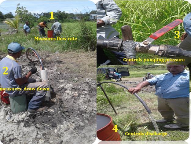
31 Pump Testing
32 Pump Test Results TIME (m) WATER DEPTH (m) A pump test was conducted over 24hrs. A draw down of the well was measured Within of 24hrs test period water level was maintained at m Bore well yield (flow rate) measured is about 2L/s
33 Draw Down Curve while pumping
")
34 Pump test results The bore pump discharge rate was set at 113 litres per minute with the pump at 23 meters. The pump was shut down at 420 minutes and the bore allowed to recharge. Based on the timer taken for the full recharge from ceassation of pumping, the bore hole is able to sustain a continual pumping rate of 113L per minute, 6780 litres per hour and daily yield (24hr) 0f 162, 720 litres


35 Production Water is been pumped out of the bore hole to pump out facility located 200m away from test bore well. 2x15000L reservoir thanks filled to capacity and pumped out at 1.56L/s to Eddai Town.


36 Is the Water Safe to Drink? Water quality test were conducted to check for presence of; Total Coliform E. Coli Faecal Coliforms and other
37 Lab Results Water Quality
38 Key Challenges Two important challenges (1) Site Selection for drilling (2) Is the flow rate or yield able to meet the demand? (3) Aquifer can be depleted quickly due to low recharge issues in the future
39 Site Selection for Drilling From the geophysical survey, 2 possible sites were selected purely based on the following criteria; A fault was detected from the resistivity survey. 300m (1) Good aquifer thickness (Eddai 03 =32.9m(Eddai05 25m) (2) Located on the footwall of a fault line NNW, SSE 45 (previous bore was located on the hanging wall of fault ). Naturally water would flow from a high elevation to low elevation.
40 Important Lesson! A new geological information was added on the existing 1:50,000 series geological map that the confirmed active fault. Ground Water can now be accessed from fractured rocks in Port Moresby A collaborative effort required from all geoscientist in successful delivery of a project safely on time and budget. Project Site CBD Koki Fault 10km
41 Conclusion Results indicated Ground Water is Fault /Fractured fractured aquifer at Boera ground water project A combination of desk top study, site survey through to drilling, well construction and pump testing indicated that the site we have selected was the ideal and most importantly safe for the bore water system.. Current bore water hole is located 300m away from the fault line. Important decisions in identifying a suitble site for bore water drilling especially along fault lines poses significant challenges in terms safety and economics. The bore is feasible and now supplying water to more than 500 houses
42 Thanks Pil Niru Senior Geotechnical Engineer Geological Survey Division Mineral Resources Authority Papua New Guinea Website:
A Preliminary Geophysical Reconnaissance Mapping of Emirau Ground Water Resource, Emirau Island, New Ireland Province, PNG
 A Preliminary Geophysical Reconnaissance Mapping of Emirau Ground Water Resource, Emirau Island, New Ireland Province, PNG Geological Survey Division of Mineral Resources Authority (MRA) Papua New Guinea
THE MINISTRY OF ENERGY AND ENERGY INDUSTRIES MINERALS DIVISION MINE DESIGN TEMPLATE OPERATOR NAME: OPERATOR ADDRESS: PHONE NUMBER: FACSIMILE:
 THE MINISTRY OF ENERGY AND ENERGY INDUSTRIES MINERALS DIVISION MINE DESIGN TEMPLATE 1.0 GENERAL INFORMATION OPERATOR NAME: OPERATOR ADDRESS: PHONE NUMBER: FACSIMILE: NAME OF CONTACT: CELLULAR PHONE: EMAIL
SEASONAL WATER STORAGE AND REPLENISHMENT OF A FRACTURED GRANITE AQUIFER USING ASR WELLS
 SEASONAL WATER STORAGE AND REPLENISHMENT OF A FRACTURED GRANITE AQUIFER USING ASR WELLS Mario R. Lluria; Phillip M. Paski; Gary G. Small HydroSystems, Incorporated Phoenix, Arizona USA Presentation Contents
M E M O R A N D U M. Mr. Jonathan K. Thrasher, P.E., Mr. Ian Kinnear, P.E. (FL) PSI
 PSI") M E M O R A N D U M TO: FROM: Mr. Mark Schilling Gulf Interstate Engineering Mr. Jonathan K. Thrasher, P.E., Mr. Ian Kinnear, P.E. (FL) PSI DATE: November 11, 2014 RE: Summary of Findings Geotechnical
M E M O R A N D U M TO: FROM: Mr. Mark Schilling Gulf Interstate Engineering Mr. Jonathan K. Thrasher, P.E., Mr. Ian Kinnear, P.E. (FL) PSI DATE: November 11, 2014 RE: Summary of Findings Geotechnical
How & Where does infiltration work? Summary of Geologic History Constraints/benefits for different geologic units
 June 26, 2007: Low Impact Development 1 Associated Earth Sciences, Inc. Associated Earth Sciences, Inc. Presented by: Matthew A. Miller, PE April 24, 2012 How & Where does infiltration work? Summary of
Subsurface Geology of the Kennebec River
 Maine Geologic Facts and Localities July, 1998 Subsurface Geology of the Kennebec River 43 54 40.75 N, 69 48 29.01 W Text by Daniel B. Locke, Department of Agriculture, Conservation & Forestry 1 Map by
Prof. Stephen A. Nelson EENS 111. Groundwater
 Page 1 of 8 Prof. Stephen A. Nelson EENS 111 Tulane University Physical Geology This page last updated on 20-Oct-2003 is water that exists in the pore spaces and fractures in rock and sediment beneath
HOW. HOW vehicle mounted units portable units also available. HOW, WHEN & WHY to Geophysically Log in S.I.?
 HOW, WHEN & WHY to Geophysically Log in S.I.? by Kim Beesley HOW HOW vehicle mounted units portable units also available Access to borehole Depth of borehole sump / rat -hole? 1 HOW? - subject to borehole
the Quarrying Industry Dewatering and the Quarrying Industry the Quarrying Industry
 Dewatering and the Quarrying Industry Dewatering and Dewatering and the Quarrying Industry the Quarrying Industry Les Brown Eugene P. Daly John Kelly Objectives 1) To present a summary of water management
=%REPORT RECONNAISSANCE OF CHISHOLM LAKE PROSPECT. October 25, 1977
 =%REPORT ON FIELD RECONNAISSANCE OF CHISHOLM LAKE PROSPECT October 25, 1977 Bruce D. Vincent Imperial Oil Limited, Minerals - Coal, CALGARY, ALBERTA CHISHOLM LAKE PROSPECT Introduction The Chisholm Lake
Project No: 68R3056 Client: City of Frederick Project: RFQ 14-H Future North Side Water Tank City/State: 7516 Hayward Road, Frederick, MD
 Boring: SB-1 (1 of 1) Moist, brown to orange brown CLAY and SILT, trace sand with fine weathered rock fragments. POSSIBLE FILL. Dry, orange brown sandy SILT trace clay (SM-ML). RESIDUAL SOIL : Not Surveyed
Hydrogeological Assessment for Part of Lots 2 and 3, Concession 5, Township of Thurlow, County of Hastings 1.0 INTRODUCTION. 1.
 February 10,2017 25506400 Ontario Ltd. Foxboro, ON Attention: Brad Newbatt Re: Hydrogeological Assessment for Part of Lots 2 and 3, Concession 5, Township of Thurlow, County of Hastings 1.0 INTRODUCTION
RESISTIVITY IMAGING AND BOREHOLE INVESTIGATION OF THE BANTING AREA AQUIFER, SELANGOR, MALAYSIA. A.N. Ibrahim Z.Z.T. Harith M.N.M.
 JOURNAL OF ENVIRONMENTAL HYDROLOGY The Electronic Journal of the International Association for Environmental Hydrology On the World Wide Web at http://www.hydroweb.com VOLUME 11 2003 RESISTIVITY IMAGING
The process of determining the layers of natural soil deposits that will underlie a proposed structure and their physical properties is generally
 The process of determining the layers of natural soil deposits that will underlie a proposed structure and their physical properties is generally referred to as sub surface investigation 2 1 For proper
Cappog Bridge (PW-3)
") Water Framework Directive Groundwater Monitoring Programme Site Information Cappog Bridge (PW-3) ImagePath1: Cappog Bridge\IEGBNI_NB_G_012_18_0 01_A_SiteLocation.jpg Cappog Bridge PW-3 is one of 8 boreholes
Water Framework Directive Groundwater Monitoring Programme Site Information Cappog Bridge (PW-3) ImagePath1: Cappog Bridge\IEGBNI_NB_G_012_18_0 01_A_SiteLocation.jpg Cappog Bridge PW-3 is one of 8 boreholes
Seepage Analysis for Shurijeh Reservoir Dam Using Finite Element Method. S. Soleymani 1, A. Akhtarpur 2
 Seepage Analysis for Shurijeh Reservoir Dam Using Finite Element Method S. Soleymani 1, A. Akhtarpur 2 1 Group of Dam Construction, Toossab Company, P.O. Box 917751569, Mashhad City, Iran, PH (+98) 511-7684091;
11/22/2010. Groundwater in Unconsolidated Deposits. Alluvial (fluvial) deposits. - consist of gravel, sand, silt and clay
 deposits. - consist of gravel, sand, silt and clay") Groundwater in Unconsolidated Deposits Alluvial (fluvial) deposits - consist of gravel, sand, silt and clay - laid down by physical processes in rivers and flood plains - major sources for water supplies
Groundwater in Unconsolidated Deposits Alluvial (fluvial) deposits - consist of gravel, sand, silt and clay - laid down by physical processes in rivers and flood plains - major sources for water supplies
Horizontal Directional Drilling: An Approach to Design and Construction. Presenter: John Briand, PE Co-Author: Danielle Neamtu, PE
 Horizontal Directional Drilling: An Approach to Design and Construction Presenter: John Briand, PE Co-Author: Danielle Neamtu, PE Presentation Outline General HDD overview Conceptual-level evaluation Detailed
Evaluation of Subsurface Formation of Pabna District, Bangladesh
 IOSR Journal of Applied Geology and Geophysics (IOSR-JAGG) e-issn: 2321 0990, p-issn: 2321 0982.Volume 1, Issue 4 (Sep. Oct. 2013), PP 30-36 Evaluation of Subsurface Formation of Pabna District, Bangladesh
GLG Chapter 7 Sedimentary Environments & Rocks
 GLG 101 - Chapter 7 Sedimentary Environments & Rocks Name Note, Oct 11: I ll be writing this study sheet over the next few days. Each day I will add questions until the entire chapter is done, hopefully
Engineer. Engineering. Engineering. (in-ja-neer ) A person trained and skilled in any of the various branches of engineering: a civil engineer
 A person trained and skilled in any of the various branches of engineering: a civil engineer") Engineer (in-ja-neer ) A person trained and skilled in any of the various branches of engineering: a civil engineer (Random House Webster s College Dictionary, 1991) CE100 Introduction to Civil Geotechnical
Engineer (in-ja-neer ) A person trained and skilled in any of the various branches of engineering: a civil engineer (Random House Webster s College Dictionary, 1991) CE100 Introduction to Civil Geotechnical
Dunkerrin - Guilfoyles Well
 Water Framework Directive Groundwater Monitoring Programme Site Information Dunkerrin - Guilfoyles Well ImagePath1: Dunkerrin - Guilfoyles Well\IE_SH_G_19_005_a_Pump House_(800_x_600).jpg Dunkerrin/ Guilfoyles
DATA REPORT GEOTECHNICAL INVESTIGATION GALVESTON CRUISE TERMINAL 2 GALVESTON, TEXAS
 DATA REPORT GEOTECHNICAL INVESTIGATION GALVESTON CRUISE TERMINAL 2 GALVESTON, TEXAS SUBMITTED TO PORT OF GALVESTON 123 ROSENBERG AVENUE, 8TH FLOOR GALVESTON, TEXAS 77553 BY HVJ ASSOCIATES, INC. HOUSTON,
Geology 12 FINAL EXAM PREP. Possible Written Response Exam Questions
 Geology 12 FINAL EXAM PREP Possible Written Response Exam Questions Use this study guide to prepare for the written response portion of the final exam. Name FINAL EXAM - POSSIBLE WRITTEN RESPONSE QUESTIONS
Lab 7: Sedimentary Structures
 Name: Lab 7: Sedimentary Structures Sedimentary rocks account for a negligibly small fraction of Earth s mass, yet they are commonly encountered because the processes that form them are ubiquitous in the
EMERGENCY INVESTIGATION OF EXTREMELY LARGE SINKHOLES, MAOHE, GUANGXI, CHINA
 EMERGENCY INVESTIGATION OF EXTREMELY LARGE SINKHOLES, MAOHE, GUANGXI, CHINA Mingtang Lei, Xiaozhen Jiang, Zhende Guan Institute of Karst Geology, CAGS, Guilin, China, mingtanglei@hotmail.com Yongli Gao
16 January 2018 Job Number: RICHARD NEWMAN C\- CLARK FORTUNE MCDONALD AND ASSOCIATES PO BOX 553 QUEENSTOWN
 16 January 2018 Job Number: 50595 RICHARD NEWMAN C\- CLARK FORTUNE MCDONALD AND ASSOCIATES PO BOX 553 QUEENSTOWN CHANSEN@CFMA.CO.NZ STORMWATER DISPOSAL ASSESSMENT Dear Richard, RDAgritech were requested
Unconventional Natural Gas A Brief Review for Instituto Petroquimica Argentina
 October 5, 2010 Unconventional Natural Gas A Brief Review for Instituto Petroquimica Argentina William L. Tittle Principal and Director of Strategy Americas and Asia Raul Arias Alvarez Senior Consultant
Geotechnical Aspects of the Ohio River Bridges Project
 Geotechnical Aspects of the Ohio River Bridges Project Mark A. Litkenhus, PE Sr. Geotechnical Engineer Stephen H. Bickel, PE Sr. Geotechnical Engineer STGEC Ohio River Bridges at Louisville Geotechnical
Answers: Internal Processes and Structures (Isostasy)
") Answers: Internal Processes and Structures (Isostasy) 1. Analyse the adjustment of the crust to changes in loads associated with volcanism, mountain building, erosion, and glaciation by using the concept
Answers: Internal Processes and Structures (Isostasy) 1. Analyse the adjustment of the crust to changes in loads associated with volcanism, mountain building, erosion, and glaciation by using the concept
Problems of building and designing on semi-rocky soils
 Problems of building and designing on semi-rocky soils D. Sursanov 1 and E. Sytchkina Construction industry Department, Perm Technical University, Perm, Russia ABSTRACT Building and designing on semi-rocky
INVESTIGATIONS OF LARGE SCALE SINKHOLE COLLAPSES, LAIBIN, GUANGXI, CHINA
 INVESTIGATIONS OF LARGE SCALE SINKHOLE COLLAPSES, LAIBIN, GUANGXI, CHINA Yongli Gao Department of Geological Sciences, Center for Water Research, University of Texas at San Antonio, TX 78249, USA, yongli.gao@utsa.edu
Groundwater Level Monitoring of the Quaternary Aquifer at Al Ain City, United Arab Emirates (UAE) using Geophysical Methods
 using Geophysical Methods") Groundwater Level Monitoring of the Quaternary Aquifer at Al Ain City, United Arab Emirates (UAE) using Geophysical Methods Ahmed Murad & Amir Gabr Geology Department UAE University Outlines Introduction
Groundwater Level Monitoring of the Quaternary Aquifer at Al Ain City, United Arab Emirates (UAE) using Geophysical Methods Ahmed Murad & Amir Gabr Geology Department UAE University Outlines Introduction
Sedimentary Rocks. Origin, Properties and Identification. Geology Laboratory GEOL 101 Lab Ray Rector - Instructor
 Sedimentary Rocks Origin, Properties and Identification Geology Laboratory GEOL 101 Lab Ray Rector - Instructor Sedimentary Rock Origin and Identification Lab Pre-Lab Internet Link Resources 1) http://www.rockhounds.com/rockshop/rockkey/index.html
DRILLED DISPLACMENT PILE PERFORMANCE IN COASTAL PLAIN AND RESIDUAL SOILS
 DRILLED DISPLACMENT PILE PERFORMANCE IN COASTAL PLAIN AND RESIDUAL SOILS Presented by: W. Morgan NeSmith, P.E. Berkel & Company Contractors Inc. 770.941.5100 mnesmith@berkelapg.com SC Engineering Conference
Waterview Connection Tunnels
 Stuart Cartwright Waterview Connection Tunnels Engineering Geology Assessment of East Coast Bays Formation from Investigation through to Construction S. Cartwright, D. Koumoutsakos, B. Hill, and C. Morrison
Chapter 12 Subsurface Exploration
 Page 12 1 Chapter 12 Subsurface Exploration 1. The process of identifying the layers of deposits that underlie a proposed structure and their physical characteristics is generally referred to as (a) subsurface
resource and vulnerability Robineau & Join, nov
 Groundwater in tropical islands resource and vulnerability Robineau & Join, nov 2007 1 Diversity of hydrogeological environments in coastal areas of tropical islands : Hydrologic conditions (surface waters)
Proposed Cemetery Thornhill Road. Tier One Hydrogeological Risk Assessment. Peter Mitchell Associates
 Proposed Cemetery Thornhill Road Tier One Hydrogeological Risk Assessment Peter Mitchell Associates January 2015 Executive Summary This report uses a desk-based risk assessment technique published by the
Soils, Hydrogeology, and Aquifer Properties. Philip B. Bedient 2006 Rice University
 Soils, Hydrogeology, and Aquifer Properties Philip B. Bedient 2006 Rice University Charbeneau, 2000. Basin Hydrologic Cycle Global Water Supply Distribution 3% of earth s water is fresh - 97% oceans 1%
IV. ENVIRONMENTAL IMPACT ANALYSIS G. GEOLOGY AND SOILS
 IV. ENVIRONMENTAL IMPACT ANALYSIS G. GEOLOGY AND SOILS The following section is a summary of the geotechnical report conducted for the proposed project. The Report of Geotechnical Investigation Proposed
New Plymouth CBD Site Subsoil Class: Results from ground investigation
 Alexander, G.J., Chin, C.Y., Kayser, C. & Bradshaw, J. (2017) New Plymouth CBD Site Subsoil Proc. 20 th NZGS Geotechnical Symposium. Eds. GJ Alexander & CY Chin, Napier New Plymouth CBD Site Subsoil Class:
depression above scarp scarp
 1 LAB 1: FIELD TRIP TO McKINLEYVILLE AND MOUTH OF THE MAD RIVER OBJECTIVES: a. to look at geomorphic and geologic evidence for large scale thrust-faulting of young sediments in the Humboldt Bay region
STRUCTURAL STABILITY ASSESSMENT
 STRUCTURAL STABILITY ASSESSMENT CFR 257.73(d) Bottom Ash Pond Complex Cardinal Plant Brilliant, Ohio October, 2016 Prepared for: Cardinal Operating Company Cardinal Plant Brilliant, Ohio Prepared by: Geotechnical
 5.2 APPENDIX D2 Geotechnical Report Jeffares & Green: 03524: Ilinge and Lesseyton Cemetery Development ILINGE AND LESSEYTON CEMETERY DEVELOPMENT - GEOTECHNICAL INVESTIGATION FINAL REPORT SEPTEMBER 2014
Geo-hazard Potential Mapping Using GIS and Artificial Intelligence
 Geo-hazard Potential Mapping Using GIS and Artificial Intelligence Theoretical Background and Uses Case from Namibia Andreas Knobloch 1, Dr Andreas Barth 1, Ellen Dickmayer 1, Israel Hasheela 2, Andreas
GEOLOGIC MAPS AND GEOLOGIC STRUCTURES A TEXAS EXAMPLE
 GEOLOGIC MAPS AND GEOLOGIC STRUCTURES A TEXAS EXAMPLE Roger Steinberg Assistant Professor of Geology Del Mar College 101 Baldwin Corpus Christi, TX 78404 361-698-1665 rsteinb@delmar.edu For the maps accompanying
LBJWC - Sinkhole Lesson
 LBJWC - Sinkhole Lesson Concept Caves and sinkholes are major openings in the ground that recharge water to the Edwards Aquifer. Objective - Students will: 1) identify a sinkhole, cave, fracture, fault,
ES 104 # 5 EARTHQUAKES:
 ES 104 Laboratory # 5 EARTHQUAKES: Epicenter Determination, Seismic Waves, and Hazards Introduction Earthquakes are vibrations of Earth caused by large releases of energy that accompany volcanic eruptions,
GEOLOGICAL PROCESSES AND MATERIALS SGM210
 University of Pretoria GEOLOGICAL PROCESSES AND MATERIALS SGM210 23 April 2014 1 SOIL PROFILING According to Jennings, Brink & Williams (1973) Very important part of a geotechnical site investigation.
AWRA PMAS Engineers Club of Philadelphia. A Geologic Perspective on Stormwater
 AWRA PMAS Engineers Club of Philadelphia A Geologic Perspective on Stormwater Toby J. Kessler, P.G. Hydrogeologist Trevor G. Woodward, P.G. Engineering Geologist September 10, 2014 Gilmore & Associates,
Integration of Seismic Refraction and 2D Electrical Resistivity in Locating Geological Contact
 Open Journal of Geology, 2013, 3, 7-12 doi:10.4236/ojg.2013.32b002 Published Online April 2013 (http://www.scirp.org/journal/ojg) Integration of Seismic Refraction and 2D Electrical Resistivity in Locating
Chapter 6 Sedimentary and Metamorphic Rock
 Chapter 6 Sedimentary and Metamorphic Rock Weathering and Erosion Wherever rock is exposed at Earth s surface, it is continuously being broken down by weathering a set of physical and chemical processes
Sedimentary Rocks. Origin, Properties and Identification. Physical Geology GEOL 101 Lab Ray Rector - Instructor
 Sedimentary Rocks Origin, Properties and Identification Physical Geology GEOL 101 Lab Ray Rector - Instructor Sedimentary Rock Origin and Identification Lab Pre-Lab Internet Link Resources 1) http://www.rockhounds.com/rockshop/rockkey/index.html
Sedimentary Rocks, our most Valuable Rocks. Or, what you will probably find when you are outdoors exploring.
 Sedimentary Rocks, our most Valuable Rocks Or, what you will probably find when you are outdoors exploring. Sedimentary rocks give us evidence to earth s earlier history. We look at processes happening
DATA ACQUISITION METHODS FOR GROUNDWATER INVESTIGATION AND THE SITING OF WATER SUPPLY WELLS
 DATA ACQUISITION METHODS FOR GROUNDWATER INVESTIGATION AND THE SITING OF WATER SUPPLY WELLS M.B.J. Foster Tetra Tech EM Inc., San Francisco, CA, USA Keywords: Groundwater, water wells, drilled wells, geophysical
Sedimentary Rocks. Origin, Properties and Identification. Physical Geology GEOL 100. Ray Rector - Instructor
 Sedimentary Rocks Origin, Properties and Identification Physical Geology GEOL 100 Ray Rector - Instructor Sedimentary Rock Origin and Identification Lab Pre-Lab Internet Link Resources 1) http://www.rockhounds.com/rockshop/rockkey/index.html
Your web browser (Safari 7) is out of date. For more security, comfort and the best experience on this site: Update your browser Ignore
 is out of date. For more security, comfort and the best experience on this site: Update your browser Ignore") Your web browser (Safari 7) is out of date. For more security, comfort and the best experience on this site: Update your browser Ignore BEDRO CK For the complete encyclopedic entry with media resources,
Your web browser (Safari 7) is out of date. For more security, comfort and the best experience on this site: Update your browser Ignore BEDRO CK For the complete encyclopedic entry with media resources,
THIS IS A NEW SPECIFICATION
 THIS IS A NEW SPECIFICATION ADVANCED GCE GEOLOGY Environmental Geology F794 * OCE / 12353* Candidates answer on the Question Paper OCR Supplied Materials: None Other Materials Required: Ruler (cm/mm) Thursday
What is a water table? What is an aquifer? What is the difference between a spring and a well?
 CHAPTER 11 3 Water Underground SECTION The Flow of Fresh Water BEFORE YOU READ After you read this section, you should be able to answer these questions: What is a water table? What is an aquifer? What
3.0 GEOLOGY AND HYDROGEOLOGY
 3.0 GEOLOGY AND HYDROGEOLOGY 3.1 Methodology The Geological Survey of Ireland (GSI) publication Geology of South Cork was consulted to establish the nature of the bedrock lithology and Quaternary sediments.
Module 9 Sedimentary Rocks
 Module 9 Sedimentary Rocks SEDIMENTARY ROCKS Rocks formed from material derived from preexisting rocks by surfacial processes followed by diagenesis There are two main classes of sedimentary rocks Clastic
Cape Breton Island Mineral Inventory Studies: A Sandstone Quarry Development Opportunity at Graham River (NTS 11F/14), Inverness County
, Inverness County") Report of Activities 2001 23 Cape Breton Island Mineral Inventory Studies: A Sandstone Quarry Development Opportunity at Graham River (NTS 11F/14), Inverness County G. J. DeMont and J. E. Hawken Compilation
Report of Activities 2001 23 Cape Breton Island Mineral Inventory Studies: A Sandstone Quarry Development Opportunity at Graham River (NTS 11F/14), Inverness County G. J. DeMont and J. E. Hawken Compilation
BELFAST SEWERS PROJECT
 BELFAST SEWERS PROJECT Adam Green - Atkins Tunnelling Scheme Overview New stormwater interceptor Tunnel Scheme within Belfast City Centre to alleviate flooding and divert storm water flows from existing
Water Framework Directive. Groundwater Monitoring Programme. Site Information. Kiltrough PWS
 Water Framework Directive Groundwater Monitoring Programme Site Information Kiltrough PWS ImagePath1: Kiltrough PWS\17_009_Kiltough_P1_SiteLo cation.jpg This monitoring point is a well that is part of
INTRODUCTION. Climate
 INTRODUCTION Climate Landslides are serious natural disasters in many parts of the world. Since the past 30 years, rainfall triggered landslides and debris flows had been one of the natural disasters of
Betsy Stevenson and Allison Mohrs (Skagit County Planning and Development Services) Jenny Baker, The Nature Conservancy
 Jenny Baker, The Nature Conservancy") TC Fisher Slough Final Design and Permitting Subject: Well Review Memorandum To: From: Betsy Stevenson and Allison Mohrs (Skagit County Planning and Development Services) Jenny Baker, The ature Conservancy
TC Fisher Slough Final Design and Permitting Subject: Well Review Memorandum To: From: Betsy Stevenson and Allison Mohrs (Skagit County Planning and Development Services) Jenny Baker, The ature Conservancy
Oola PWS - Carrigmore BH
 Water Framework Directive Groundwater Monitoring Programme Site Information Oola PWS - Carrigmore BH ImagePath1: Oola PWS - Carrigmore BH\OolaPWSCarrigmore1.jpg Oola PWS Carrigmore BH is a borehole used
Hydro One (Sept 2014) Hydro One (Sept 2014) Hydro One (Sept 2014)
 Hydro One (Sept 2014) Hydro One (Sept 2014)") TABLE 1 WELL CONSTRUCTION DETAILS MOE WWR No Well ID Location Installation Date Status Easting Coordinates Northing Source Elevation Screened Interval Screened Material Borehole Well Stick-up Ground Top
TABLE 1 WELL CONSTRUCTION DETAILS MOE WWR No Well ID Location Installation Date Status Easting Coordinates Northing Source Elevation Screened Interval Screened Material Borehole Well Stick-up Ground Top
Delineation of Zones at Risk from Groundwater Inflows at an Underground Platinum Mine in South Africa
 Delineation of Zones at Risk from Groundwater Inflows at an Underground Platinum Mine in South Africa Mr Andreas Stoll andreas.stoll@erm.com Environmental Resources Management Swiss GmbH (ERM), Switzerland
patersongroup Mineral Aggregate Assessment 3119 Carp Road Ottawa, Ontario Prepared For Mr. Greg LeBlanc March 7, 2014 Report: PH2223-REP.
 Geotechnical Engineering Environmental Engineering group Hydrogeology Geological Engineering Archaeological Studies Materials Testing 3119 Carp Road Prepared For Mr. Greg LeBlanc March 7, 2014 Paterson
Explain how rock composition affects the rate of weathering. Discuss how surface area affects the rate at which rock weathers.
 Objectives Explain how rock composition affects the rate of weathering. Discuss how surface area affects the rate at which rock weathers. Describe the effects of climate and topography on the rate of weathering.
Underground Drilling and Packer Test in Fault F16 of Wugou Coal Mine
 An Interdisciplinary Response to Mine Water Challenges - Sui, Sun & Wang (eds) 2014 China University of Mining and Technology Press, Xuzhou, ISBN 978-7-5645-0125-5 Underground Drilling and Packer Test
Pierce County Department of Planning and Land Services Development Engineering Section
 Page 1 of 7 Pierce County Department of Planning and Land Services Development Engineering Section PROJECT NAME: DATE: APPLICATION NO.: PCDE NO.: LANDSLIDE HAZARD AREA (LHA) GEOLOGICAL ASSESSMENT REPORT
GEOTECHNICAL PHASE 1
 GEOTECHNICAL PHASE 1 FOR PROPOSED SKUKUZA SAFARI LODGE FOR KRUGER NATIONAL PARK MPUMALANGA PROVINCE SEPTEMBER 2014 Report No: G14-0902 Issue 2 Prepared by: Conic North Consulting Engineers PO Box 11862
14 Geotechnical Hazards
 Volume 2: Assessment of Environmental Effects 296 14 Geotechnical Hazards Overview This Chapter provides an assessment of the underlying geotechnical conditions to identify: any potential liquefaction
Re: Steep Slope Assessment for 2465 Waverly Drive, Blind Bay, BC; Legal Address: Lot 39, Section 18, Township 22, Range 10, Plan 25579, W6M, KDYD.
 OEL File 1563-1 May 30, 2017 Doug Wall PO Box 774 Salmon Arm, BC V1E 4N7 Re: Steep Slope Assessment for 2465 Waverly Drive, Blind Bay, BC; Legal Address: Lot 39, Section 18, Township 22, Range 10, Plan
Finding Large Capacity Groundwater Supplies for Irrigation
 Finding Large Capacity Groundwater Supplies for Irrigation December 14, 2012 Presented by: Michael L. Chapman, Jr., PG Irrigation Well Site Evaluation Background Investigation Identify Hydrogeologic Conditions
 Photo 1 - Southerly view across 2700 parking lot toward existing building. Multi-residential building borders western side of property in upper right of view. Photo 2 - Southerly view across 2750 parking
Sacramento Valley Groundwater Basin, Sutter Subbasin
 Sacramento Valley Groundwater Basin, Sutter Subbasin Groundwater Basin Number: 5-21.62 County: Sutter Surface Area: 234,400 acres (366 square miles) Boundaries and Hydrology The Sutter Subbasin lies in
Appendix J. Geological Investigation
 Appendix J Geological Investigation Appendix J Geological Environment Table of Contents Page 1 INTRODUCTION...J-1 1.1 Purpose of the Investigation...J-1 1.2 Scope of the Investigation...J-1 2 METHODO OF
KRIS wsbssm. IBHiiilll
 KRIS wsbssm IBHiiilll Digitized by the Internet Archive in 2012 with funding from University of Illinois Urbana-Champaign http://archive.org/details/engineeringaspec34ekbl STATE OF ILLINOIS HENRY HORNER,
Initial Borehole Drilling in the Hornepayne and Manitouwadge Area
 MAY 2017 PRELIMINARY ASSESSMENT OF POTENTIAL SUITABILITY Initial Borehole Drilling in the Hornepayne and Manitouwadge Area In 2010, the Nuclear Waste Management Organization (NWMO) began technical and
Depth (ft) USCS Soil Description TOPSOIL & FOREST DUFF
 USCS Soil Description TOPSOIL & FOREST DUFF") Test Pit No. TP-6 Location: Latitude 47.543003, Longitude -121.980441 Approximate Ground Surface Elevation: 1,132 feet Depth (ft) USCS Soil Description 0 1.5 1.5 5.0 SM 5.0 8.0 SM Loose to medium dense,
Test Pit No. TP-6 Location: Latitude 47.543003, Longitude -121.980441 Approximate Ground Surface Elevation: 1,132 feet Depth (ft) USCS Soil Description 0 1.5 1.5 5.0 SM 5.0 8.0 SM Loose to medium dense,
Tuesday 6 June 2017 Afternoon
 Oxford Cambridge and RSA Tuesday 6 June 2017 Afternoon A2 GCE GEOLOGY F794/01 Environmental Geology *6783378785* Candidates answer on the Question Paper. OCR supplied materials: None Other materials required:
UNIT 4 SEDIMENTARY ROCKS
 UNIT 4 SEDIMENTARY ROCKS WHAT ARE SEDIMENTS Sediments are loose Earth materials (unconsolidated materials) such as sand which are transported by the action of water, wind, glacial ice and gravity. These
Appendix F4.11 Geologic Unit Summaries, Hazard Areas, and Boring Locations
 Appendix F4.11 Geologic Unit Summaries, Hazard Areas, and Boring Locations Appendix F4.11 Geologic Unit Summaries and Hazard Areas TABLE F4.11-1 Summary of Geologic Units and their Engineering Properties
How to Identify and Properly Classify Drill Cuttings
 How to Identify and Properly Classify Drill Cuttings (Creating Useful Borehole Logs) Dave Larson Hydrogeology and Geophysics Section Accurate information about the borehole location and a careful description
Exploration Significance of Unconformity Structure on Subtle Pools. 1 Vertical structure characteristics of unconformity
 Exploration Significance of Unconformity Structure on Subtle Pools Wu Kongyou (China University of Petroleum,College of Geo-Resources and Information,Shandong Qingdao 266555) Abstract: Vertical structure
ENGINEER S CERTIFICATION OF FAULT AREA DEMONSTRATION (40 CFR )
") PLATTE RIVER POWER AUTHORITY RAWHIDE ENERGY STATION BOTTOM ASH TRANSFER (BAT) IMPOUNDMENTS LARIMER COUNTY, CO ENGINEER S CERTIFICATION OF FAULT AREA DEMONSTRATION (40 CFR 257.62) FOR COAL COMBUSTION RESIDUALS
PLATTE RIVER POWER AUTHORITY RAWHIDE ENERGY STATION BOTTOM ASH TRANSFER (BAT) IMPOUNDMENTS LARIMER COUNTY, CO ENGINEER S CERTIFICATION OF FAULT AREA DEMONSTRATION (40 CFR 257.62) FOR COAL COMBUSTION RESIDUALS
Field Geologists' Manual. AuslfTlfT) Monograph 9 FIFTH EDITION THG MINERALS INSTITUTE. Published by:
 Monograph 9 FIFTH EDITION THG MINERALS INSTITUTE. Published by:") Field Geologists' Manual FIFTH EDITION Monograph 9 AuslfTlfT) THG MINERALS INSTITUTE Published by: THE AUSTRALASIAN INSTITUTE OF MINING AND METALLURGY Ground Floor, 204 Lygon Street, Carlton Victoria 3053
Field Geologists' Manual FIFTH EDITION Monograph 9 AuslfTlfT) THG MINERALS INSTITUTE Published by: THE AUSTRALASIAN INSTITUTE OF MINING AND METALLURGY Ground Floor, 204 Lygon Street, Carlton Victoria 3053
MICHIGAN GEOLOGICAL SURVEY Coastal Navigator Training St. Joseph, Michigan What do we know about anthropogenic impact(s) to Lake Michigan shorelines?
 to Lake Michigan shorelines?") MICHIGAN GEOLOGICAL SURVEY Coastal Navigator Training St. Joseph, Michigan What do we know about anthropogenic impact(s) to Lake Michigan shorelines? Review of a 12 year shoreline study and today, what
MICHIGAN GEOLOGICAL SURVEY Coastal Navigator Training St. Joseph, Michigan What do we know about anthropogenic impact(s) to Lake Michigan shorelines? Review of a 12 year shoreline study and today, what
PRECAMBRIAN CRYSTALLINE AQUIFER (METAMORPHIC ROCKS)
") HAYWARD QUADRANGLE: Groundwater Production by Aquifer In the 56-square-mile area of the Hayward Quadrangle, groundwater is produced from metamorphic crystalline rocks of the Precambrian basement (in the
HAYWARD QUADRANGLE: Groundwater Production by Aquifer In the 56-square-mile area of the Hayward Quadrangle, groundwater is produced from metamorphic crystalline rocks of the Precambrian basement (in the
Site investigation results versus tunnelling conditions a study with emphasis on water leakage based on Norwegian cases
 Site investigation results versus tunnelling conditions a study with emphasis on water leakage based on Norwegian cases Kristin H. Holmøy, Bjørn Nilsen Norwegian University of Science and Technology, Department
Water Framework Directive. Groundwater Monitoring Programme. Site Information. Galbally
 Water Framework Directive Groundwater Monitoring Programme Site Information Galbally ImagePath1: Galbally\Galbally1.jpg Galbally source is comprised of 2 boreholes situated in Devonian Old Red Sandstones
Section I: Multiple Choice Select the best answer to each question. Mark your final answer on the answer sheet. (1 pt each)
") Sedimentary Rocks & Surface Processes Quest Name: Earth Science 2013 Block: Date: Section I: Multiple Choice Select the best answer to each question. Mark your final answer on the answer sheet. (1 pt each)
Sedimentary Rocks & Surface Processes Quest Name: Earth Science 2013 Block: Date: Section I: Multiple Choice Select the best answer to each question. Mark your final answer on the answer sheet. (1 pt each)
Coal Layer Identification using Electrical Resistivity Imaging Method in Sinjai Area South Sulawesi
 Journal of Physics: Conference Series PAPER OPEN ACCESS Coal Layer Identification using Electrical Resistivity Imaging Method in Sinjai Area South Sulawesi To cite this article: Andi Ilham Samanlangi 2018
KANSAS GEOLOGICAL SURVEY Open File Report LAND SUBSIDENCE KIOWA COUNTY, KANSAS. May 2, 2007
 KANSAS GEOLOGICAL SURVEY Open File Report 2007-22 LAND SUBSIDENCE KIOWA COUNTY, KANSAS Prepared by Michael T. Dealy L.G., Manager, Wichita Operations SITE LOCATION The site was approximately four miles
Evaluation of Structural Geology of Jabal Omar
 International Journal of Engineering Research and Development e-issn: 2278-067X, p-issn: 2278-800X, www.ijerd.com Volume 11, Issue 01 (January 2015), PP.67-72 Dafalla Siddig Dafalla * and Ibrahim Abdel
Water Framework Directive. Groundwater Monitoring Programme. Site Information. Tir na League
 Water Framework Directive Groundwater Monitoring Programme Site Information Tir na League ImagePath1: Tir na League\IE_NW_G_078_05_005_ A_PumpHouse.jpg Tir na League is an infiltration gallery situated