CHAPTER 4: COALBED GAS IN THE BOURBON ARCH
|
|
|
- Jessie Hood
- 5 years ago
- Views:
Transcription
1 138 CHAPTER 4: COALBED GAS IN THE BOURBON ARCH
2 Introduction The Bourbon arch of eastern Kansas is a mature petroleum province with conventional hydrocarbon production in the declining stages over the past fifty years. Most conventional production is currently stripper production (Newell et al., 2002). Coalbed gas production can be dated back to the 1910 s, when it was then known as shale-gas (Charles and Page, 1929). Documented areas of shale-gas production at the time include Miami and southeastern Johnson counties of Kansas, and northwest Cass and southwest Jackson counties in Missouri; small areas near Garnett and Mound City in Anderson and Linn counties, respectively; and southern Allen, eastern Wilson and Montgomery, and western Neosho and Labette counties of southeastern Kansas (Charles and Page, 1929). These counties correspond to present-day hotspot coalbed gas plays and pilot projects in eastern Kansas (Newell et al., 2002; 2004). Completion targets of shale-gas wells were the Little Osage Shale (and Summit coal) and Excello Shale (and Mulky coal) of the Marmaton and Cherokee groups, and to a lesser extent the deeper shales and accompanying coals of the Cherokee Group (Fig. 3.02). Gas production was reported to range from 10 to 300 thousand cubic feet per day (Mcfd), with a typical well producing 40 Mcfd of shale-gas. A few extraordinary wells were reported to produce 900 Mcfd in the Paola-Kansas City area of Miami and Johnson counties, Kansas. However, such high production rates were short-lived, lasting only a few days (Charles and Page, 1929). Eastern Kansas coal was originally exploited by more conventional means. Approximately 300 million tons (270 million metric tons) of coal was mined over the
3 140 past 150 years, with most production occurring south of the current study area in southeastern Kansas. Peak production occurred in the earlier half of the 20 th century during both world wars. One open-pit coal mine currently operates in eastern Kansas exploiting the Mulberry coal in Linn County (Brady, 1997). Over the past two decades, coal-sourced natural gas has revitalized the petroleum industry in eastern Kansas (Fig. 4.01). Interest first originated in the early 1980 s. Increased activity was triggered by coal-gas industry tax incentives in the early 1990 s. Tax incentives have since been phased out and the current activity is the result of increasing gas prices and newer exploration and completion technologies (Stoeckinger, 1990; Newell et al., 2002). The first coalbed gas content analysis was reported from Wilson and Montgomery counties in southeast Kansas (Stoeckinger, 1990). Initial desorption analyses reported more than 200 standard cubic feet per ton (scf/ton) for the Mulky coal, more than 220 scf/ton for the Weir-Pittsburg coal, and more than 190 scf/ton for the Riverton coal in the Cherokee basin (Stoeckinger, 1990). Similar analyses for the Forest City basin showed gas contents ranging from 50 to 435 scf/ton (Tedesco, 1992). In 1990, coal gas desorption from a cored-well by the Kansas Geological Survey in Leavenworth County yielded coalbed gas contents ranging from 20 to 94 scf/ton (Bostic et al., 1993). The bulk of Kansas coalbed gas production is currently concentrated in the Cherokee basin. However, new production and coalbed gas pilot projects are slowly migrating northward across the Bourbon arch and into Forest City basin (Fig. 1.05). Northward expansion is controlled by the pre-existing pipeline infrastructure, which

4 141
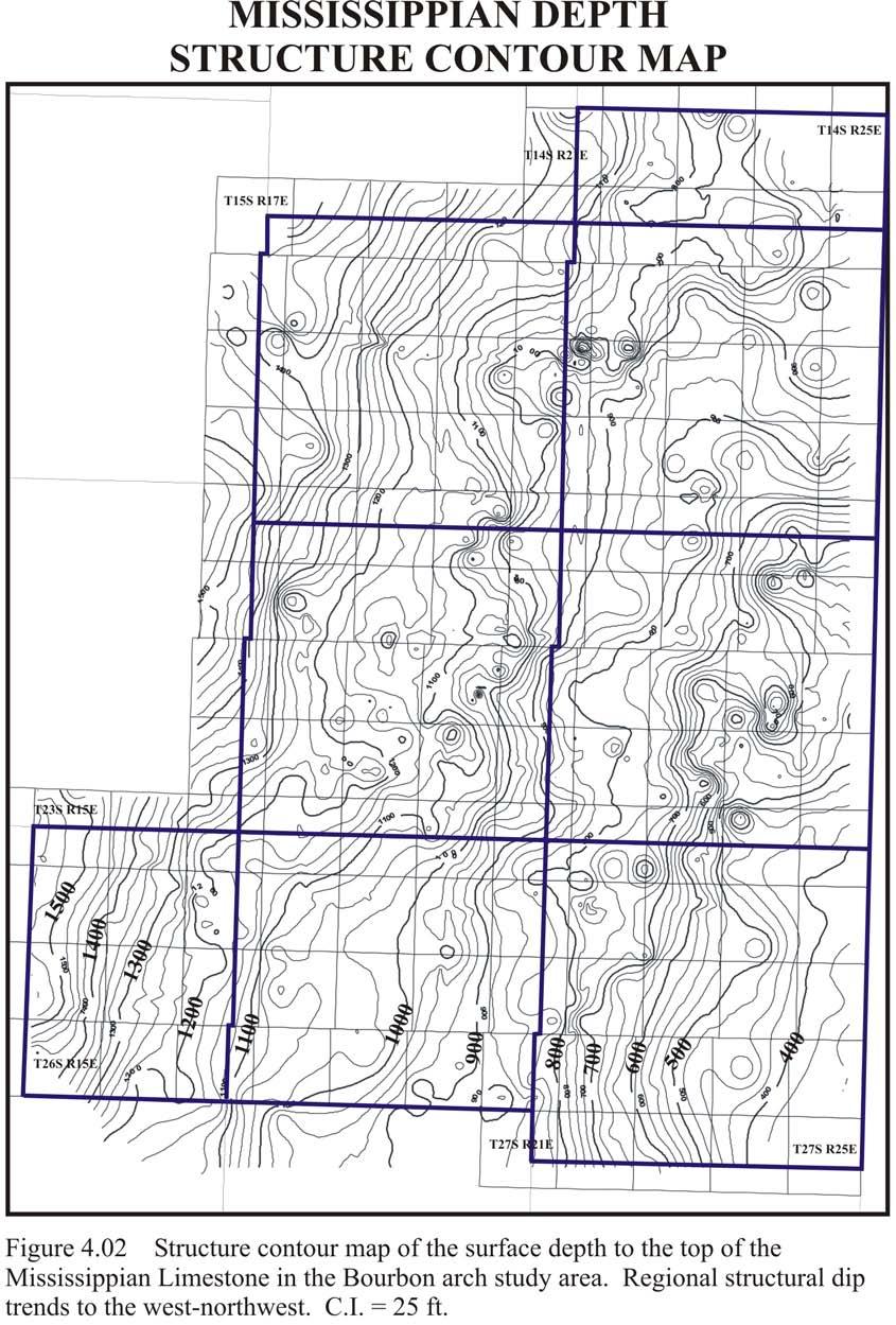
5 142 connects the eastern Kansas coalbed gas region to several large markets (Fig. 1.05; Johnson et al., 2003). In addition to the pipeline infrastructure, several other positive factors influence coalbed gas production in eastern Kansas. These factors include: 1) High natural gas prices; 2) Low drilling costs due to the shallowness coal seams in eastern Kansas (< 2500 ft. [< 760 m]). The top of the Mississippian Limestone represents the maximum depth of Desmoinesian coals in eastern Kansas (Fig. 4.02); 3) Sufficient overburden for coalbed gas production and retention (Fig. 4.02); 4) Overlying seals of thick shale, which may also serve as possible gas sources adding to the total well productivity; 5) Possible fallback and upside opportunities on conventional hydrocarbon sources; 6) The high probability of encountering multiple coal beds (up to 14) within a single well (Brady, 1997; Newell et al., 2002); 7) Inexpensive salt-water disposal in the Cambrian-Ordovician Arbuckle Group located 200 to 400 feet (60- to 120 m) below the Mississippian- Pennsylvanian boundary. Disposal pumps are unnecessary since the Arbuckle Group is significantly below hydrostatic pressure (Newell et al. 2002, 2004). 8) The industry-friendly nature of eastern Kansas. Relative to other coalbed gas-producing regions in the United States, land in eastern Kansas is
6 143
7 144 predominately privately owned and landowners are open to industry development (Tedesco, 2003). 9) A local petroleum industry provides a pre-existing energy infrastructure. Several factors negatively affect coalbed gas exploitation potential in eastern Kansas. 1) The coal rank (high volatile A- to C-bituminous) is less than ideal (medium-volatile bituminous) for coalbed gas generation (Rightmire, 1984; Brady, 1997). 2) The thinness of individual coal beds increases the difficulty of completion, and may negatively affect gas rates. Preliminary resource evaluation indicated that 85% of coal occurs in beds 14 to 28 inches (0.5 to 1.0 m) and the remaining 15% occurs in beds greater than 28 inches (>1.0 m; Brady, 1997). 3) Coalbed permeability in eastern Kansas is highly variable from well to well and within the same coal seam. Permeability values are reported to range from 0.01 to 500 md, averaging md in productive areas (Tedesco, 2003). Calcite and other mineralization have been observed in cleats in various areas of eastern Kansas. Gas contents derived from desorption of coal samples (excluding residual gas content) in the area are presented and compared to samples from the Cherokee basin. When combined with coal isopach maps and volumetric analysis, an estimate of original gas in place (OGIP) is calculated for the Bourbon arch. An analysis of coalbed gas geochemistry is also presented.
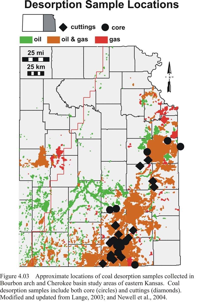
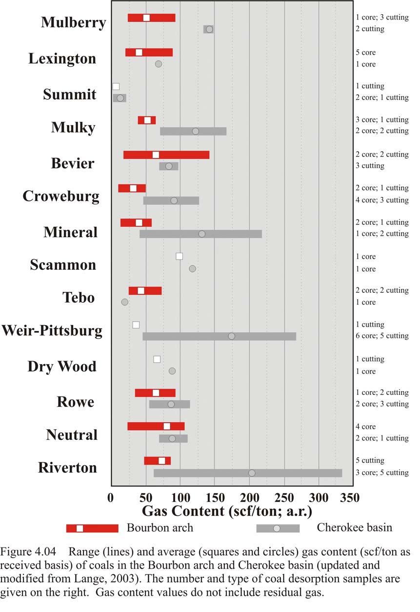
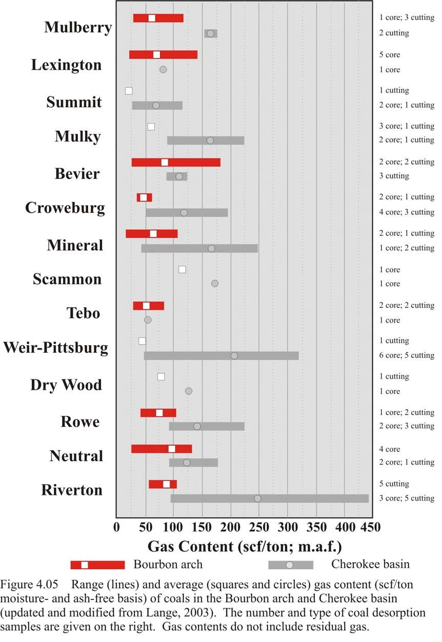
8 Gas Content Desorption Results Over the past five years the Kansas Geological Survey, in cooperation with several local coalbed methane operators, has carried out coal sampling for gas desorption in eastern Kansas. Coal desorption samples were collected from both cores and cuttings (Fig. 4.03). The methodology of coal sampling and desorption is described in Chapter 1. Gas contents (standard cubic feet per ton; scf/ton) for both the Bourbon arch and Cherokee basin study areas are reported as received (a.r.) and moisture- and ash-free (m.a.f.) bases (Figs and 4.05). The number of samples from individual coals and their nature (core or cuttings) is also reported. In the Bourbon arch, 23 core samples and 21 cuttings samples were analyzed as received, while 27 of each type were analyzed as received in the Cherokee basin. Based on 44 samples, coalbed gas contents of major coals in the Bourbon arch range from 5.2 to scf/ton (a.r.; Fig. 4.04) and 16.7 to scf/ton (m.a.f.; Fig. 4.05). Coals with the highest gas contents on the Bourbon arch are the Riverton, Neutral, Rowe, Scammon, Mineral, Bevier, Lexington, and Mulberry (Figs and 4.05). Gas contents on the Bourbon arch are generally lower than those in the Cherokee basin. Based on 54 samples, Cherokee basin coalbed gas contents range from 3.2 to scf/ton (a.r.; Fig. 3.04) and from 28.3 to scf/ton (m.a.f.; Fig. 3.05; Lange, 2003). Desorption analysis of coalbed gas contents include lost gas and desorbed gas components. Coalbed gas contents presented in this study do not include residual gas.
9 146
10 147
11 148
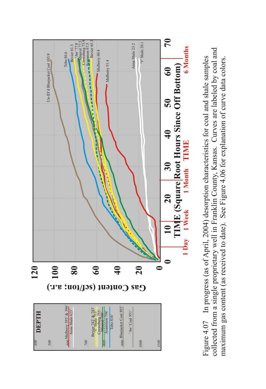
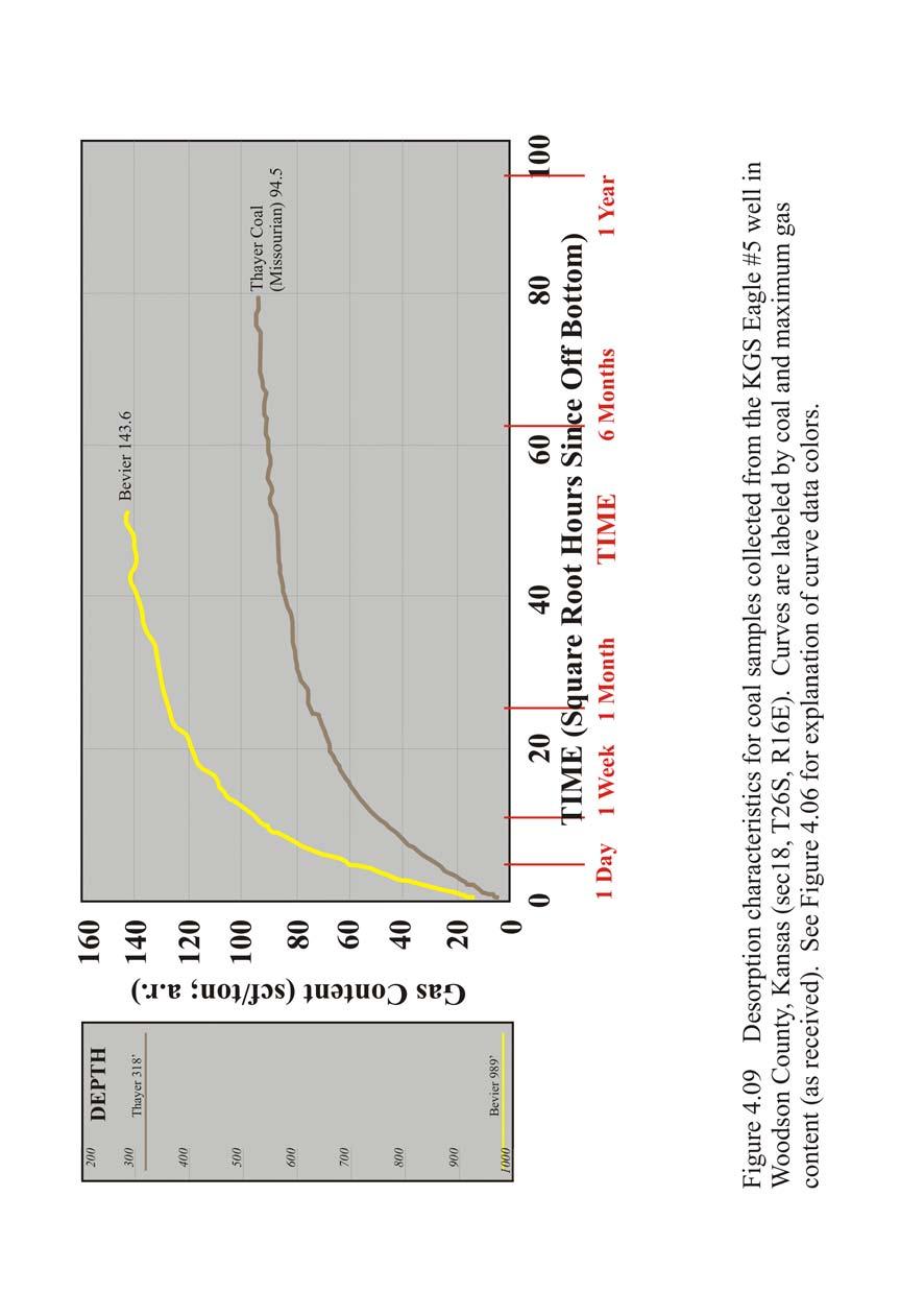
12 149 Coal data points and curves are color-coded based on relative stratigraphic position (Fig. 4.06). Warmer colors represent stratigraphically higher coals such as the Mulberry and Lexington, while cooler colors represent stratigraphically lower coals such as the Neutral and Riverton. The desorption characteristics of coals are presented on an as received basis for individual counties (Franklin, Miami, Woodson, and Cass County, Missouri; Figs. 4.07, 4.08, 4.09, and 4.10).
13 150
14 151
15 152
16 153
17 154 Gas contents for cuttings are typically lower than those of core samples. This is due to the increased surface area of cuttings from pulverization during drilling. The increased surface area results in greater lost gas prior to canistering. The greater surface area also increases the rate and decreases the duration of desorption. On the other hand, the greater speed of cuttings reaching the surface may also affect lost gas estimates. Cuttings lag time the travel time between the bottom of the hole and the surface may be several tens of seconds, whereas the time for cores to reach the surface may be several minutes. Gas contents of cuttings have been reported as 24-28% less than core equivalents (Mavor et al., 1992). Nelson (1999) suggested cuttings desorbed 25-30% less gas than cores. A consistent correlation between gas contents of cores and cuttings has not been demonstrated. Continuing research at the Kansas Geological Survey is attempting to determine the relationship between gas contents from cores and cuttings. Cuttings were analyzed and segregated into shale and coal following sample decanistering. An average gas content of 3 scf/ton (as received) for shale in eastern Kansas was assumed in calculation of gas content of the coal portion of the sample (K.D. Newell, personal communication, 2004) Coal and Coalbed Gas Resource Estimate Using average coalbed gas contents and digital subsurface coal isopach maps, coalbed gas resources in the Bourbon arch were estimated. Coal mass (C m ), is estimated by the equation: C m = C A-F *T/(A-F) (1)
18 155 where C A-F is the volume of coal (acre-feet) and T/(A-F) is tons of coal per acre-foot. Based on an average specific gravity of 1.32 for bituminous coal, a value of 1800 tons per acre-foot was used for T/A-F (Averitt, 1974). C A-F was calculated from coal isopach maps for the coal volume greater than 1.0 foot (0.3 m). A thickness cutoff of 1 foot (0.3 m) reflects the present minimum completion thickness in the Bourbon arch. Original gas in place of each coal seam (OGIP in scf) was computed with the equation: OGIP = G c * C m (2) by multiplying the average gas content for each seam (G c ) by the mass of each coal (C m ) as calculated from Equation 1. The numbers of coal samples (cuttings and core) desorbed are presented in Figure Total original gas in place (TOGIP) for the Bourbon arch, summed from the 14 coals mapped in the current study, is estimated to be trillion cubic feet (tcf; Table 4.1). This compares to a TOGIP for the Cherokee basin of tcf (Lange, 2003).
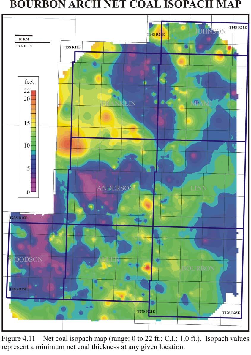
19 156 Table 4.1 Volumetric calculation values for the Bourbon arch. Coal Avg. Gas Content (scf/ton; Gc) Coal Volume >1.0 ft. (Acre-feet; T/A-F) Coal Mass (short tons; Cm) OGIP (bcf) Mulberry ,824,560 3,284,208, Lexington , ,319, Summit 5.2 1,278,413 2,301,143, Mulky ,009,245 3,616,641, Bevier ,283,729 7,710,712, Croweburg ,890,609 3,403,096, Mineral ,817,834 3,272,101, Scammon ,138,216 2,048,788, Tebo ,352,736 2,434,924, Weir-Pittsburg ,129,632 2,033,337, Dry Wood , ,006, Rowe ,740 1,034,532, Neutral ,031,500 1,856,700, Riverton ,623,110 4,721,598, Total OGIP (bcf) A net coal isopach of all significant, mapped coals in the study area ranges from 0 to 22 feet (0 to 6.7 m), averaging 9.0 feet (2.7 m) across the Bourbon arch study area (Fig. 4.11). Thicker net coal isopach values occur in southern Johnson, southern and western Franklin, central Miami, central Linn, eastern Allen, and western Bourbon counties. Additional local coals may be present in a well log at any given location and increase the net coal value of an individual well. In areas with historical hydrocarbon production from relatively shallow, upper-cherokee or Marmaton reservoirs, many wells do not penetrate the entire coal-bearing sequence and deeper coals. As a result, deeper coals may not be adequately represented.
20 157
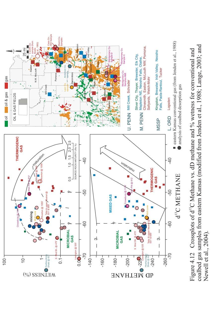
21 Coalbed Gas Geochemistry Coalbed gas is commonly termed coalbed methane given that methane is typically the highest concentration. Other components include heavier hydrocarbon gases such as ethane and propane. Nonhydrocarbon components include nitrogen, carbon dioxide, hydrogen sulfide, and helium (Rightmire, 1984; Rice, 1993). Geochemical analysis of coal gas samples provides insight into the origin of coalbed gas, and possible coalbed gas production fairways in eastern Kansas. Conventional gas from fields in eastern Kansas originated from both thermogenic and microbial processes (Jenden et al., 1988). Thermogenic gas results from the thermal cracking of kerogen during catagenesis between temperatures of 80 to 150 C (wet, associated gas) and 150 to 200 C (dry, non-associated gas). The process of microbial CO 2 reduction forms gas at temperatures up to 80 C, as methanogenic bacteria reduce CO 2 and H 2 to form CH 4 and water. Microbial processes produce dry, non-associated gas (Hunt, 1996). Gases from Mississippian and Pennsylvanian strata in Kansas are both associated and non-associated, whereas Permian and younger gases tend to be drier (non-associated), and pre-mississippian gases tend to be wetter (associated; Jenden et al., 1988). Crossplots of δ 13 C and δd, and δ 13 C and methane wetness are used to determine the origins of both conventional and unconventional gases (Fig. 4.12). More negative δ 13 C indicates methane with a high proportion of light carbon isotopes. More negative δd indicates methane with a high proportion of light hydrogen isotopes. Lighter δ 13 C and δd isotopes are indicative of dry microbial gas generation,
22 159 while heavier δ 13 C and δd isotopes are indicative of wet thermogenic gas generation. Methanogenic bacteria preferentially consume lighter carbon and hydrogen isotopes during microbial CO 2 reduction, resulting in more negative δ 13 C and δd values relative to thermogenic gas (Hunt, 1996). When δ 13 C and δd values, and δ 13 C and methane wetness values are crossplotted for conventional associated (oilfield) and non-associated (gasfield) gases from eastern Kansas, thermogenic and microbial CO 2 reduction origins are indicated (Fig. 4.12; Jenden et al., 1988). Coalbed gas samples were collected by the Kansas Geological Survey and sent to a commercial laboratory for gas isotopic analysis. Isotopic analysis of coalbed gas samples of δ 13 C versus δd, and δ 13 C versus percent methane wetness compositions suggest mixed thermogenic and microbial origins, as well as dominantly microbial origins (Fig. 4.12; Jenden et al., 1988). Pennsylvanian rocks are marginally mature to mature based on vitrinite reflectance values ranging from 0.5 to 0.8% (Jenden et al., 1988; Walton et al., 1995). Given low maturity, conventional and coalbed gases likely originated from a combination of indigenous microbial CO 2 reduction, and indigenous and early-migrated thermogenic origins. Long-distance migration was from thermally mature source rocks in the Arkoma basin to the south (Jenden et al., 1988). Gas composition and isotopic data show that coalbed gas samples have a greater thermogenic signature with increasing depth into the basin. Shallower updip coals tend to be less gassy and have more microbial signatures. As a result, coals have a generally greater gas content in the Cherokee basin than in the Bourbon arch
23 160
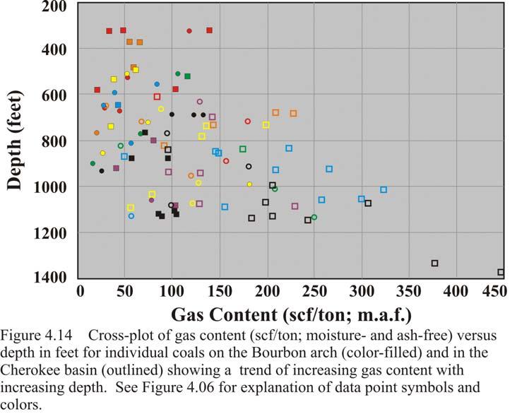
24 161 (Figs and 4.05). In addition, coal seam gas contents generally increase with depth within a given well. Coalbed gas content data for the Smith #1-22 well in Cass County, Missouri (Fig. 4.10); the Franklin County, Kansas well (Fig. 4.07); and the Woodson County well (Fig. 4.09) follow this trend. However, in the Rose Hill #1-6 well of Miami County, Kansas, one of the shallowest coals (e.g. Lexington at 576 ) has much higher gas content relative to deeper coals in the same well (Fig. 4.08). According to the Lexington s gas isotope values in Figure 4.12, a microbial origin may account for the relatively high gas content. Other proprietary data points support this trend (e.g. Hushpuckney Shale sample from Anderson County and certain Montgomery County D samples; K.D. Newell, personal communication, 2004). The possibility exists of a shallow, updip production fairway composed of microbial gas exists on the Bourbon arch. Additional data is required to better define the contribution of biogenic coal gas in eastern Kansas. 4.4 Gas Content Relationships Gas contents of coals from the Cherokee basin and Bourbon arch were crossplotted with associated values for depth (feet), ash content (wt. %), and calorific value (Btu/lb). A general trend of increasing gas content (both as received and moistureand ash-free) with increasing depth exists for coals in eastern Kansas (Figs and 4.14, respectively). A similar trend was suggested in the Cherokee basin; gas contents were greater for deeper coals in Montgomery County, Kansas, than shallower, regionally updip coals in adjacent Labette County to the east (Lange,
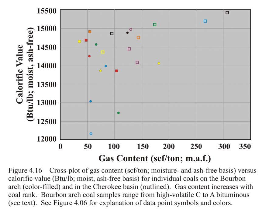
25 ). Individual coals (e.g. Rowe and Riverton) may also show trends of increasing gas content with depth (Figs and 4.14). The relationship between depth and gas content may be related to increased hydrostatic pressure at greater depths, which results in higher quantities of adsorbed gas. Additionally, thermogenic processes typically increase with greater depths. Although the relationship between gas content and thermogenic versus microbial origin is inconclusive, the gas content of thermogenic or mixed nature is generally higher than pure microbial gas (Figs. 6.07; 6.08; 6.10; and 6.17). Microbial gas can have intermediate to high gas contents locally, as in the Lexington coal of Rose Hill #1-6 in Miami County (Figs. 6.08; 6.17). As depth and thermogenic signature increase, coalbed gas content in the western portions of the study area and Cherokee basin is generally greater than on the Bourbon arch. No apparent trend exists between gas content (scf/ton; m.a.f.) and ash content (wt. %; moisture-free) for eastern Kansas coals as a whole, but several individual coals exhibit weak trends of increasing gas content with increasing ash content (Fig. 4.15). While highly variable, a cleaner coal can have relatively high gas content, whereas coals with higher ash content are expected to have low to moderate gas content (Fig. 4.15). A trend of increasing gas content (scf/ton; m.a.f.) with increasing coal rank, or calorific value (Btu/lb) also exists for coals in eastern Kansas (Fig. 4.16). Coals with calorific values greater or equal to 14,000 Btu/lb are classified as high volatile A-bituminous (Rightmire, 1984). Coals with calorific values between 13,000 and 14,000 are classified as high-volatile B bituminous. One coal sample

26 163 plotted within the high-volatile C bituminous range (11,500 to 13,000 Btu/lb; Fig. 4.15).

27 164
28 165
Chapter Three: Coalbed Gas in the Cherokee Basin
 Chapter Three: Coalbed Gas in the Cherokee Basin The first test in Kansas to assess coalbed gas potential in southeastern Kansas was from several wells drilled during the late 1980 s in Wilson and Montgomery
Regional Trends in Coalbed Gas Composition and Thermal Maturation in Eastern Kansas: Implications for Predicting Quality and Location of Coalbed Gas
 Regional Trends in Coalbed Gas Composition and Thermal Maturation in Eastern Kansas: Implications for Predicting Quality and Location of Coalbed Gas K. David Newell and L. Michael Magnuson Kansas Geological
CHAPTER 3: COAL-BEARING INTERVALS OF THE BOURBON ARCH
 68 CHAPTER 3: COAL-BEARING INTERVALS OF THE BOURBON ARCH 69 3.1 Introduction The examination of Desmoinesian coal-bearing intervals includes: 1) facies successions and their associated well-log characteristics;
CHAPTER 1: INTRODUCTION
 CHAPTER 1: INTRODUCTION 2 1.1 Introduction The Middle Pennsylvanian Series in east-central Kansas includes numerous coal seams within both siliciclastic and mixed carbonate-siliciclastic sedimentary successions,
Issues Related to Oklahoma Coalbed- Methane Activity,
 Figure 1. Map of the eastern Oklahoma coalfield (modified from Friedman, 1974). Issues Related to Oklahoma Coalbed- Methane Activity, 1988 2008 Brian J. Cardott Oklahoma Geological Survey INTRODUCTION
29 th Forum of the Coal Geologists of the Western Interior Coal Region. Field Trip May 25, 2005
 29 th Forum of the Coal Geologists of the Western Interior Coal Region Field Trip May 25, 2005 Phoenix Coal Co. Garland Mine, Bourbon Co., KS and Coalbed Methane Operations of Dart Cherokee Basin Operating
APPENDIX O GEOCHEMISTRY OF NATURAL GAS AND COALBED METHANE
 APPENDIX O GEOCHEMISTRY OF NATURAL GAS AND COALBED METHANE Appendix O Geochemistry of Natural Gas and Coalbed Methane Primary gases originate from bacterial respiration (biogenic) and thermal alteration
Atlantic Rim Coalbed Methane Play: The Newest SuccessfulCBM Play in the Rockies
 Atlantic Rim Coalbed Methane Play: The Newest SuccessfulCBM Play in the Rockies Robert A. Lamarre Lamarre Geological, Denver, Colorado Stephen K. Ruhl Anadarko Petroleum Corporation, The Woodlands, Texas
U.S. Shale Gas. From Resources and Reserves to Carbon Isotope Anomalies. John B. Curtis Potential Gas Agency Colorado School of Mines
 U.S. Shale Gas From Resources and Reserves to Carbon Isotope Anomalies John B. Curtis Potential Gas Agency Colorado School of Mines Major U.S. Basins and Shale Plays c. 2007 (Where are the Haynesville
0708 Carbon Sequestration and Enhanced Coalbed Methane Recovery Potential of the Cahaba and Coosa Coalfields in the Southern Appalachian Thrust Belt
 0708 Carbon Sequestration and Enhanced Coalbed Methane Recovery Potential of the Cahaba and Coosa Coalfields in the Southern Appalachian Thrust Belt M. R. McIntyre and J. C. Pashin Geological Survey of
Chapter 4: Sequence Stratigraphy of the Cherokee Group
 Chapter 4: Sequence Stratigraphy of the Cherokee Group 4.1 Sequence Stratigraphic Nomenclature Sequence stratigraphic concepts provide a framework to better explain and predict the lateral distribution,
secarb.org Southeast Regional Carbon Sequestration Partnership (SECARB) Central Appalachian Coal Seam Project
 Central Appalachian Coal Seam Project") Southeast Regional Carbon Sequestration Partnership (SECARB) secarb.org Field Test Location Russell County, Virginia Amount and Sources of CO 2 1,000 Tons from Commercial Source Primary Contacts DOE/NETL
Southeast Regional Carbon Sequestration Partnership (SECARB) secarb.org Field Test Location Russell County, Virginia Amount and Sources of CO 2 1,000 Tons from Commercial Source Primary Contacts DOE/NETL
Petroleum Systems (Part One) Source, Generation, and Migration
 Source, Generation, and Migration") Petroleum Systems (Part One) Source, Generation, and Migration GEOL 4233 Class January 2008 Petroleum Systems Elements Source Rock Migration Route Reservoir Rock Seal Rock Trap Processes Generation Migration
Petroleum Systems (Part One) Source, Generation, and Migration GEOL 4233 Class January 2008 Petroleum Systems Elements Source Rock Migration Route Reservoir Rock Seal Rock Trap Processes Generation Migration
OGIP Evaluation of Shale Gas and CBM with Basin Modeling and Gas Isotopes Interpretation*
 OGIP Evaluation of Shale Gas and CBM with Basin Modeling and Gas Isotopes Interpretation* Daniel Xia 1,2 and Yongchun Tang 1 Search and Discovery Article #40842 (2011) Posted November 30, 2011 *Adapted
LAS ANIMAS ARCH PROVINCE (040)
") LAS ANIMAS ARCH PROVINCE (040) By C. William Keighin INTRODUCTION The Las Animas Arch of southeastern Colorado is a north-northeast striking structural high, bounded on the south by the Apishipa Uplift.
LAS ANIMAS ARCH PROVINCE (040) By C. William Keighin INTRODUCTION The Las Animas Arch of southeastern Colorado is a north-northeast striking structural high, bounded on the south by the Apishipa Uplift.
Methane gas potential of coal as national alternative energy reserves in Indonesia
 Proceeding of ISBN 978-602-17952-1-7 2 nd International Conference on Sustainable Energy Engineering and Application Grand Hotel Preanger, Bandung, Indonesia 14 15 October 2014 Methane gas potential of
secarbon.org Southeast Regional Carbon Sequestration Partnership (SECARB) Central Appalachian Coal Seam Project
 Central Appalachian Coal Seam Project") Southeast Regional Carbon Sequestration Partnership (SECARB) secarbon.org Field Test Location Russell County, Virginia Amount and Sources of CO 2 1,000 Tons from Commercial Source Primary Contacts DOE/NETL
Southeast Regional Carbon Sequestration Partnership (SECARB) secarbon.org Field Test Location Russell County, Virginia Amount and Sources of CO 2 1,000 Tons from Commercial Source Primary Contacts DOE/NETL
Overview of Unconventional Energy Resources of Oklahoma
 Overview of Unconventional Energy Resources of Oklahoma By Brian J. Cardott (Oklahoma Geological Survey) Presented at OGS Conference on Unconventional Energy Resources in the Southern Midcontinent in Oklahoma
Hydrocarbon Processing Techniques
 Hydrocarbon Processing Techniques Processes and Techniques Involved in Extracting and Refining Hydrocarbons Key term: Kerogen a mixture of organic matter in sediments from which petroleum is released.
Steve Cumella 1. Search and Discovery Article # (2009) Posted July 30, Abstract
 Posted July 30, Abstract") AV Geology of the Piceance Basin Mesaverde Gas Accumulation* Steve Cumella 1 Search and Discovery Article #110106 (2009) Posted July 30, 2009 *Adapted from oral presentation at AAPG Annual Convention,
AV Geology of the Piceance Basin Mesaverde Gas Accumulation* Steve Cumella 1 Search and Discovery Article #110106 (2009) Posted July 30, 2009 *Adapted from oral presentation at AAPG Annual Convention,
U.S. Department of the Interior Alaska Rural Energy Project
 U.S. Department of the Interior Alaska Rural Energy Project Results from the Coalbed Methane Exploration and Testing Project Wainwright, Alaska 2007-2008 2008 Art Clark U.S. Geological Survey, Denver,
Evaluating Suitability of Appalachian Basin Reservoirs for NGLs Storage Jessica Moore, West Virginia Geological & Economic Survey
 1 THE APPALACHIAN STORAGE HUB STUDY: Evaluating Suitability of Appalachian Basin Reservoirs for NGLs Storage Jessica Moore, West Virginia Geological & Economic Survey 2 ASH STUDY OUR GOAL Complete a geologic
SHALE GAS/ OIL: OPPORTUNITIES CMPDI S ENDEAVOURS
 SHALE GAS/ OIL: OPPORTUNITIES & CMPDI S ENDEAVOURS KEY POINTS 1. India s Energy Scenario 2. Development of Non-conventional energy resources. 3. Shale Gas : Generation and Storage 4. Shale Gas: CMPDI s
COAL-BED METHANE POTENTIAL OF THE MINERAL COAL BED (SENORA FORMATION, DESMOINESIAN SERIES) OKMULGEE COUNTY, OKLAHOMA
 OKMULGEE COUNTY, OKLAHOMA") COAL-BED METHANE POTENTIAL OF THE MINERAL COAL BED (SENORA FORMATION, DESMOINESIAN SERIES) OKMULGEE COUNTY, OKLAHOMA FIELD TRIP GUIDEBOOK By Samuel A. Friedman PREPARED FOR THE MID-CONTINENT SECTION BIENNIAL
COAL-BED METHANE POTENTIAL OF THE MINERAL COAL BED (SENORA FORMATION, DESMOINESIAN SERIES) OKMULGEE COUNTY, OKLAHOMA FIELD TRIP GUIDEBOOK By Samuel A. Friedman PREPARED FOR THE MID-CONTINENT SECTION BIENNIAL
Coalbed Methane Potential and Current Realisation in Indonesia
 Coalbed Methane Potential and Current Realisation in Indonesia Michael Bowe 1 and Tim A. Moore 2 1 Ephindo Energy Ltd., Jakarta, Indonesia 2 Cipher Consulting Ltd., Brisbane, Australia Abstract Conventional
GEOLOGICAL LOG INTERPRETATION TUTORIAL
 GEOLOGICAL LOG INTERPRETATION TUTORIAL Text and Figures by Geoff Bohling and John Doveton The following pages will familiarize you with the basics of the geological interpretation of common logs as they
LeBLANC JR., RUFUS, Exploration Technologies, Inc., Houston, TX ; VICTOR T. JONES, III, Exploration Technologies, Inc.
 LeBLANC JR., RUFUS, Exploration Technologies, Inc., Houston, TX ; VICTOR T. JONES, III, Exploration Technologies, Inc., Houston, TX How to Design an Exploration Surface Soil Gas Geochemical Survey: Illustrated
New Albany Shale? Brandon C. Nuttall, Speaker Kentucky Geological Survey KOGA, Louisville, Ky 16 Jul 2014
 Oil and NGLs in the Devonian New Albany Shale? Brandon C. Nuttall, Speaker Kentucky Geological Survey KOGA, Louisville, Ky 16 Jul 2014 Natural Gas Phases at 1 Atm Benzene (C6) Hexane (C6) Pentane (C5)
Experienced specialists providing consulting services worldwide. Coalbed Methane Consulting Services
 Experienced specialists providing consulting services worldwide Coalbed Methane Consulting Services Proven technical leadership Schlumberger is a world leader in coalbed methane (CBM) engineering and geosciences.
MESOZOIC BASINS. North Carolina Geological Survey
 MESOZOIC BASINS North Carolina Geological Survey The 1823 organic act which created the North Carolina Geological Survey (NCGS) tasked us to examine, describe and map the geology, geologic hazards, and
Uses of Stable Isotopes in Petroleum.
 Uses of Stable Isotopes in Petroleum. Isotopes in Petroleum Isotope- atoms with the same atomic number but different mass number In the past the use of stable isotopes in petroleum was not common. With
INTRODUCTION TABLE OF CONTENTS. Energy Symposium Master Drillers 8/12/2010. Shale Operations Charlie Scott 1. Operations in Pennsylvania & Shale Plays
 Operations in Pennsylvania & Shale Plays I. INTRODUCTION II. GENERAL DESCRIPTION OF A SHALE PLAY A. WHAT IS A SHALE PLAY B. WHERE ARE THEY C. WHAT MAKES THEM DIFFERENT III. MARCELLUS PLAY A. AREA B. HISTORY
Lines-of-Evidence Approach to the Evaluation of Stray Gas Incidents
 Lines-of-Evidence Approach to the Evaluation of Stray Gas Incidents Lisa Molofsky, Ann Smith, John Connor, Shahla Farhat GSI Environmental Inc. Tom Wagner, Albert Wylie Cabot Oil and Gas Corporation GSI
SCOOP Woodford. Regional Field Study
 SCOOP Woodford Regional Field Study OVERVIEW The Woodford shale is an organic rich siliceous shale formation of late Devonian and early Mississippian age deposited throughout most of the Anadarko basin
Unconventional Shale Gas & Conventional Opportunities in the Quebec Lowlands, Quebec Canada. Exploration Assets Management, LLC Wylie Texas 75098
 Unconventional Shale Gas & Conventional Opportunities in the Quebec Lowlands, Quebec Canada Exploration Assets Management, LLC Wylie Texas 75098 Jim Morabito 25 October, 2011 The Leap to Quebec Utica Shale
Oil Shale Project in Thailand
 Oil Shale Project in Thailand Progress of Oil Shale Exploration in Thailand (Phase 2) The cooperation of Thai agencies between Department of Mineral Fuels (DMF) and Electricity Generating Authority of
COOPER BASIN DRILLING TO EVALUATE UNCONVENTIONAL POTENTIAL
 The Company Announcement Officer ASX Limited via electronic lodgement COOPER BASIN DRILLING TO EVALUATE UNCONVENTIONAL POTENTIAL OUR STRENGTHS Quality Assets Experienced Team Major Growth Potential The
Follow this and additional works at: Part of the Geology Commons
 Western Michigan University ScholarWorks at WMU Michigan Geological Repository for Research and Education Geosciences 2016 Geology of Michigan William B. Harrison III Michigan Geological Repository for
Analysis Of Light Hydrocarbons In Soil-Gases, Lost River Region West Virginia: Relation To Stratigraphy And Geological Structures.
 Analysis Of Light Hydrocarbons In Soil-Gases, Lost River Region West Virginia: Relation To Stratigraphy And Geological Structures. Harbert, W., Jones, V. T., Izzo, J, and Anderson, T. H. Department of
Conducted by the Midwest Regional Carbon Sequestration Partnership (MRCSP)
") FINAL REPORT UNDERSTANDING DEEP COAL SEAMS FOR SEQUESTRATION POTENTIAL Conducted by the Midwest Regional Carbon Sequestration Partnership (MRCSP) DOE-NETL Cooperative Agreement DE-FC26-05NT42589 Prepared
FINAL REPORT UNDERSTANDING DEEP COAL SEAMS FOR SEQUESTRATION POTENTIAL Conducted by the Midwest Regional Carbon Sequestration Partnership (MRCSP) DOE-NETL Cooperative Agreement DE-FC26-05NT42589 Prepared
Presentation to the NATIONAL BUYER / SELLER FORUM March 24, Brad J. Hayes Petrel Robertson Consulting Ltd.
 Presentation to the NATIONAL BUYER / SELLER FORUM March 24, 2010 Brad J. Hayes Petrel Robertson Consulting Ltd. Canada s Gas Resources the Picture in 2010 This gas resource picture is only a snapshot because
Lower Skinner Valley Fill Sandstones: Attractive Exploration Targets on the Northeast Oklahoma Platform*
 Lower Skinner Valley Fill Sandstones: Attractive Exploration Targets on the Northeast Oklahoma Platform* By Jim Puckette 1 Search and Discovery Article #10050 (2003) *Adapted from presentation to Tulsa
Petroleum Potential of the Application Area L12-4
 Petroleum Potential of the Application Area L12-4 The Application Area (L12-4) is underlain by the western Officer Basin, beneath the Gunbarrel Basin. The general basin architecture is outlined in Figure
Reconnaissance of Coal-Slurry Deposits in Indiana. IGS Web Report
 Reconnaissance of Coal-Slurry Deposits in Indiana Denver Harper Chris Dintaman Maria Mastalerz Sally Letsinger August 1, 2006 - April 30, 2007 Indiana Geological Survey Bloomington, Indiana 1 IGS Web Report
Fred Baldassare, P.G. September 28, Sr. Geoscientist. Prepared for
 Fred Baldassare, P.G. Sr. Geoscientist Christopher Laughrey, Sr. Geosciences Advisor, Weatherford Laboratories, Mark McCaffrey, Ph.D., Sr. Technical Advisor, Weatherford Laboratories, John Harper, Ph.D.,
MODULE PREREQUISITES FOR HYDROCARBON ACCUMULATION
 MODULE 1 1.0 PREREQUISITES FOR HYDROCARBON ACCUMULATION The accumulation of hydrocarbons and formation of oil or gas deposit involve certain prerequisites. These are the following: 1. Source Rock 2. Reservoir
KANSAS GEOLOGICAL SURVEY Open File Report LAND SUBSIDENCE KIOWA COUNTY, KANSAS. May 2, 2007
 KANSAS GEOLOGICAL SURVEY Open File Report 2007-22 LAND SUBSIDENCE KIOWA COUNTY, KANSAS Prepared by Michael T. Dealy L.G., Manager, Wichita Operations SITE LOCATION The site was approximately four miles
CoalBed Methane Fact and Future In Oklahoma
 OKLAHOMA CORPORATION COMMISSION Oil and Gas Conservation Division CoalBed Methane Fact and Future In Oklahoma November 24 Jamal Daneshfar, PE Out Lines:. Fact and figures about Coal bed methane. Regulation
Calcite Cements in Middle Devonian Dunedin Formation:
 Geochemistry of the Fracture-Filling Dolomite and Calcite Cements in Middle Devonian Dunedin Formation: Implication for the Strata Dolomitization Model Sze-Shan Yip 1, Hairuo Qing 1 and Osman Salad Hersi
Unconventional Reservoir Development: The Role of Geoscience from a State Regulator s Perspective
 Unconventional Reservoir Development: The Role of Geoscience from a State Regulator s Perspective Nick Tew Alabama State Geologist and Oil and Gas Supervisor President, American Geosciences Institute Geological
Application of methane clumped isotopologue measurements for tracing the subsurface history of hydrocarbon gases
 Application of methane clumped isotopologue measurements for tracing the subsurface history of hydrocarbon gases David T. Wang Shuhei Ono MIT WHOI Joint Program Department of Earth, Atmospheric and Planetary
MIDWEST REGIONAL CARBON SEQUESTRATION PARTNERSHIP PHASE II STORAGE CAPACITY POTENTIAL OVERVIEW
 FINAL MIDWEST REGIONAL CARBON SEQUESTRATION PARTNERSHIP PHASE II STORAGE CAPACITY POTENTIAL OVERVIEW SUMMARY OF PHASE II TOPICAL REPORTS DOE-NETL Cooperative Agreement DE-FC26-05NT42589 Submitted by: Battelle
IVANHOE COMMENCES RESOURCE DELINEATION DRILLING AT NARIIN SUKHAIT COAL PROJECT IN MONGOLIA S SOUTH GOBI
 January 12, 2005 IVANHOE COMMENCES RESOURCE DELINEATION DRILLING AT NARIIN SUKHAIT COAL PROJECT IN MONGOLIA S SOUTH GOBI ULAANBAATAR, MONGOLIA Ivanhoe Mines Chairman Robert Friedland and President John
CARTER METALLURGICAL COAL PROJECT. Endurance Gold Corporation (EDG)
") CARTER METALLURGICAL COAL PROJECT McDOWELL COUNTY, WEST VIRGINIA Endurance Gold Corporation (EDG) Endurance Resources Inc. (ERI) Prepared by: Duncan McIvor, President and CEO Endurance Gold Corporation
CARTER METALLURGICAL COAL PROJECT McDOWELL COUNTY, WEST VIRGINIA Endurance Gold Corporation (EDG) Endurance Resources Inc. (ERI) Prepared by: Duncan McIvor, President and CEO Endurance Gold Corporation
Burket/Geneseo Shale Appalachia s little brother to the Marcellus & Utica
 Burket/Geneseo Shale Appalachia s little brother to the Marcellus & Utica Gregory Wrightstone Presented at: WrightstoneEnergy.com October 8, 2015 Pittsburgh Association of Petroleum Geologists Pittsburgh,
Education Days Moscow Opening Session
 Education Days Moscow 2013 Basin and Petroleum Systems Modelling: Applications for Conventional and Unconventional Petroleum Exploration Risk and Resource Assessments By Dr Bjorn Wygrala Schlumberger 21-22
3D Modeling of the Santa Terezinha Coalfield, Brazil - implications for estimation of the CBM potential
 3D Modeling of the Santa Terezinha Coalfield, Brazil - implications for estimation of the CBM potential H. Burger, R. Prissang 1, M. Holz and W. Kalkreuth 2 1 Institut für Geologische Wissenschaften, FU
Unconventional Oil Plays Opportunity vs Risk
 Unconventional Oil Plays Opportunity vs Risk EnerCom s London Oil & Gas Conference 4 June 14, 2012 Sofitel London Danny D. Simmons 1000 BOPD - What a great well! 10,000 1,000 BOPD 100 10 12/2009 1/2010
Stephanie B. Gaswirth and Kristen R. Mara
 U.S. Geological Survey Assessment of Undiscovered Resources in the Bakken and Three Forks Formations, Williston Basin, North Dakota, Montana, and South Dakota, 2013 Stephanie B. Gaswirth and Kristen R.
Bulletin of Earth Sciences of Thailand. Evaluation of the Petroleum Systems in the Lanta-Similan Area, Northern Pattani Basin, Gulf of Thailand
 Evaluation of the Petroleum Systems in the Lanta-Similan Area, Northern Pattani Basin, Gulf of Thailand Sirajum Munira Petroleum Geoscience Program, Department of Geology, Faculty of Science, Chulalongkorn
Barnett Shale-Woodford Shale play of the Delaware basin is it another giant shale gas field in Texas?
 Barnett Shale-Woodford Shale play of the Delaware basin is it another giant shale gas field in Texas? Bob Cluff The Discovery Group, Inc Denver, Colorado, USA bobcluff@discovery-group.com Delaware basin
Exploration, Drilling & Production
 Nontechnical Guide to PETMOLEUM Geology, Exploration, Drilling & Production Third Edition Norman J. Hyne, Ph.D. Contents Preface *i Introduction 1 The Nature of Gas and Oil 1 Petroleum 1 The Chemistry
CO 2 adsorption in coals as a function of rank and composition: A task in USGS research on geologic sequestration of CO 2
 CO 2 adsorption in coals as a function of rank and composition: A task in USGS research on geologic sequestration of CO 2 Robert C. Burruss USGS, Reston, VA Project Tasks 1. Adsorption Properties of Coals
Gas content evaluation in unconventional reservoir
 Gas content evaluation in unconventional reservoir Priyank Srivastava Unconventional reservoirs 1 Average monthly prod. (mscf) The Problem Gas in-place calculation Prediction of production decline Total
AAPG European Region Annual Conference Paris-Malmaison, France November RESOURCES PERSPECTIVES of the SOUTHERN PERMIAN BASIN AREA
 AAPG European Region Annual Conference Paris-Malmaison, France 23-24 November 2009 RESOURCES PERSPECTIVES of the SOUTHERN PERMIAN BASIN AREA J.C. DOORNENBAL, TNO Built, Environment and Geosciences, Geological
Oklahoma Shale Resource Plays
 APRIL-JUNE 2017 Oklahoma Shale Resource Plays By Brian J. Cardott INTRODUCTION The petroleum system concept includes the generation, migration, and accumulation of hydrocarbons (Magoon and Dow, 1994; Magoon
2003 GCSSEPM Foundation Ed Picou Fellowship Grant for Graduate Studies in the Earth Sciences Recipient
 2003 GCSSEPM Foundation Ed Picou Fellowship Grant for Graduate Studies in the Earth Sciences Recipient Tarek A. El Shayeb University of Texas at Austin Integrated reservoir characterization and 3-D diagenetic
PRECAMBRIAN CRYSTALLINE AQUIFER (METAMORPHIC ROCKS)
") HAYWARD QUADRANGLE: Groundwater Production by Aquifer In the 56-square-mile area of the Hayward Quadrangle, groundwater is produced from metamorphic crystalline rocks of the Precambrian basement (in the
HAYWARD QUADRANGLE: Groundwater Production by Aquifer In the 56-square-mile area of the Hayward Quadrangle, groundwater is produced from metamorphic crystalline rocks of the Precambrian basement (in the
Geochemistry and Origin of Some Natural Gases in the Plateau Province, Central Appalachian Basin, Pennsylvania and Ohio 1
 Geochemistry and Origin of Some Natural Gases in the Plateau Province, Central Appalachian Basin, Pennsylvania and Ohio 1 C. D. Laughrey 2 and F. J. Baldassare 3 ABSTRACT We sampled gases from 22 wells
Farnham Dome and Grassy Trails Fields, Utah
 Farnham Dome and Grassy Trails Fields, Utah CO 2 accumulation sources and migration paths Matthew Merrill 1, Andrew Hunt 2 1 U.S. Geological Survey, Reston, VA USA 2 U.S. Geological Survey, Lakewood, CO
Chapter 2: Coal Deposits of the Cherokee Basin
 Chapter 2: Coal Deposits of the Cherokee Basin Previous work by Harris (1984) and Stanton (1987) divided the Cherokee Group into ten stratigraphic intervals using laterally persistent dark-gray to black
Stratigraphy and Hydrocarbon Production from Pennsylvanian Age Granite Wash Reservoirs in the Western Anadarko Basin, Oklahoma and Texas
 Stratigraphy and Hydrocarbon Production from Pennsylvanian Age Granite Wash Reservoirs in the Western Anadarko Basin, Oklahoma and Texas John Mitchell, Managing Partner/Consulting Geologist Fall River
Update on Prospectivity Studies of the Georgina and Cooper Basins
 Update on Prospectivity Studies of the Georgina and Cooper Basins Dianne Edwards, Lisa Hall, Bridget Ayling and the Onshore Energy Systems Group, Resources Division Northern Territory, Queensland and South
REFERENCES CITED. Averitt, P., 1974, Coal resources of the United States, January 1, 1974; U.S. Geological Survey Bulletin 1412, p
 240 REFERENCES CITED Abernathy, G.E., 1936, The Cherokee Group of southeastern Kansas: unpublished doctoral dissertation, University of Kansas, 108 p. Aitken, J.F., 1994, Coal in a sequence stratigraphic
Evaluation of Neocomian Shale source rock In Komombo Basin, Upper Egypt
 Evaluation of Neocomian Shale source rock In Komombo Basin, Upper Egypt Abdelhady, A. 1, Darwish, M. 2, El Araby, A. 3 and Hassouba, A. 4 1 DEA Egypt, Cairo, Egypt 2 Geology Department, Faculty of Science,
BARAKA SEEKS HELIUM & CONVENTIONAL HYDROCARBON POTENTIAL
 ASX ANNOUNCEMENT/MEDIA RELEASE 21 ST May 2018 BARAKA SEEKS HELIUM & CONVENTIONAL HYDROCARBON POTENTIAL Baraka Energy & Resources Limited (ASX: BKP) (Baraka) or (the Company) having now been recapitalized
4. Carboniferous Zone Play Results
 C H A P T E R F O U R 4. Carboniferous Zone Play Results 4. Geological Overview In the WCSB, there were two main depositional areas during Carboniferous time the Peace River Embayment in northwestern Alberta,
EXAMINER S REPORT AND RECOMMENDATION STATEMENT OF THE CASE
 OIL AND GAS DOCKET NO. 08-0248239 THE APPLICATION OF PETRO-HUNT, L.L.C. TO CONSIDER NEW FIELD DESIGNATION AND FIELD RULES FOR THE (PROPOSED) TOYAH, NW (SHALE) FIELD, REEVES COUNTY, TEXAS Heard by: Donna
Armour Energy Limited 27 May 2014 New Technical Data Further Derisks the Extensive Shale Play in ATP1087, Queensland
 Armour Energy Limited 27 May 2014 New Technical Data Further Derisks the Extensive Shale Play in ATP1087, Queensland Highlights: World class Total Organic Carbon (TOC) content in Lawn and Riversleigh Shales.
Platt s 22 nd Annual Coal Properties And Investment
 Platt s 22 nd Annual Coal Properties And Investment Demand and Production of Thermal and Met Coal Palm Beach Gardens, Florida March 17 18, 2014 Alan K. Stagg Stagg Resource Consultants, Inc. U.S Metallurgical
Licence P1368: Relinquishment Report (end of 2 nd term) Hurricane Exploration PLC
 Hurricane Exploration PLC") Licence P1368: Relinquishment Report (end of 2 nd term) Hurricane Exploration PLC March 2012 1. Header Licence Number: P1368 Licence Round: 23 rd Licence Type: Frontier Block Numbers: 202/4, 202/5, 204/30,
Licence P1368: Relinquishment Report (end of 2 nd term) Hurricane Exploration PLC March 2012 1. Header Licence Number: P1368 Licence Round: 23 rd Licence Type: Frontier Block Numbers: 202/4, 202/5, 204/30,
Devonian Petroleum Systems and Exploration Potential, Southern Alberta, Part 3 Core Conference
 Devonian Petroleum Systems and Exploration Potential, Southern Alberta, Part 3 Core Conference Andy Mort (1), Leonard Stevens (2), Richard Wierzbicki (2) Abstract Part 1: Devonian Petroleum Systems Dr.
Analysis of Micro-fractures in Coal for Coal Bed Methane Exploitation in Jharia Coal Field
 5th Conference & Exposition on Petroleum Geophysics, Hyderabad-2004, India PP 904-909 Analysis of Micro-fractures in Coal for Coal Bed Methane Exploitation in Jharia Coal Field Dipak Mandal, D.C. Tewari
ENHANCEMENT OF THE APPALACHIAN BASIN DEVONIAN SHALE RESOURCE BASE IN THE GRI HYDROCARBON MODEL. GRI Contract No
 ENHANCEMENT OF THE APPALACHIAN BASIN DEVONIAN SHALE RESOURCE BASE IN THE GRI HYDROCARBON MODEL GRI Contract No. 5095-890-3478 Prepared for: Gas Research Institute 1600 Wilson Boulevard Suite 900 Arlington,
Non-conventional gas
 2.2 Non-conventional gas 2.2.1 Introduction Definition The expression non-conventional gas, historically, has meant many different things to different governments, organizations, and public/private businesses.
Overview of Selected Shale Plays in New Mexico*
 Overview of Selected Shale Plays in New Mexico* Ron Broadhead 1 Search and Discovery Article #10627 (2014)** Posted August 18, 2014 *Adapted from presentation at RMAG luncheon meeting, Denver, Colorado,
Dr. Kenneth B. Taylor, P.G.
 North Carolina Forestry Association 2013 Annual Meeting October 3, 2013 Shale Gas 101: Natural Gas Exploration / Development: A North Carolina Perspective presented by Dr. Kenneth B. Taylor, P.G. State
Subsurface Geology and Resource Exploration
 LAB 11. Subsurface Geology and Resource Exploration Locating earth resources such as aluminum, copper, gold and gemstones has been an important job for geologists for a long time. This lab deals with the
PRESSURE CONDITIONS AND COAL QUALITY IN THE BLACK WARRIOR BASIN: IMPLICATIONS FOR CO 2 SEQUESTRATION
 TEMPERATURE-PRESSURE PRESSURE CONDITIONS AND COAL QUALITY IN THE BLACK WARRIOR BASIN: IMPLICATIONS FOR CO 2 SEQUESTRATION Jack C. Pashin,, Richard E. Carroll, and J. Wayne Payton GEOLOGICAL SURVEY OF ALABAMA
Petroleum Systems of the San Joaquin Basin: Characterization of Oil and Gas Types
 Stanford University BPSM Industrial Affiliates Summer Meeting July 28, 2008 Petroleum Systems of the San Joaquin Basin: Characterization of Oil and Gas Types Les Magoon = References Lillis, P.G., and Magoon,
Overview of Woodford Gas-Shale Play in Oklahoma, 2008 Update
 Oklahoma Gas Shales Conference October 22, 2008 Overview of Woodford Gas-Shale Play in Oklahoma, 2008 Update Brian J. Cardott Oklahoma Geological Survey Number of Wells 300 250 200 Oklahoma Shale-Gas Well
COALBED METHANE PRIMER: FROM A NUISANCE TO A DARLING ENERGY RESOURCE IN FIFTY- PLUS YEARS. Part One
 COALBED METHANE PRIMER: FROM A NUISANCE TO A DARLING ENERGY RESOURCE IN FIFTY- PLUS YEARS Author: Dr. Mihir K. Sinha; 3 Hamilton Lane, Plainsboro, NJ 08536, Phone#609-799-8789 E-mail: Mihirsinha@comcast.net
Unconventional Natural Gas A Brief Review for Instituto Petroquimica Argentina
 October 5, 2010 Unconventional Natural Gas A Brief Review for Instituto Petroquimica Argentina William L. Tittle Principal and Director of Strategy Americas and Asia Raul Arias Alvarez Senior Consultant
A Review of Three North American Shale Plays: Learnings from Shale Gas Exploration in the Americas*
 A Review of Three North American Shale Plays: Learnings from Shale Gas Exploration in the Americas* David Waldo 1 Search and Discovery Article #80214 (2012)** Posted May 28, 2012 *Adapted from oral presentation
WESTCARB Phase I Results Review
 WESTCARB Phase I Results Review Arizona Geologic Characterization Errol Montgomery Principal Errol L. Montgomery & Associates (520) 881-4912 emontgomery@elmontgomery.com November 9, 2005 Site Characterization
OIL SHALE OCCURRENCES IN UPPER ASSAM BASIN, INDIA : AN OVERVIEW
 OIL SHALE OCCURRENCES IN UPPER ASSAM BASIN, INDIA : AN OVERVIEW V.K.Sibal Srinivasan V.Raju Directorate General of Hydrocarbons New Delhi SEDIMENTARY BASIN MAP OF INDIA 2 HYDROCARBON RESOURCE BASE Sedimentary
Wongai Project Presentation
 Wongai Project Presentation 16 September, 2014 Geos Mining Limited Andrew Todd, Coal Resource Specialist (JORC competent) 7 years: 8 years: coal resource geologist - New Zealand and Indonesia; coal quality
APPENDIX C GEOLOGICAL CHANCE OF SUCCESS RYDER SCOTT COMPANY PETROLEUM CONSULTANTS
 APPENDIX C GEOLOGICAL CHANCE OF SUCCESS Page 2 The Geological Chance of Success is intended to evaluate the probability that a functioning petroleum system is in place for each prospective reservoir. The
SL GEOLOGY AND MINING. Coal bearing strata in the project area are referable primarily to the Allegheny Group of
 SL-145-1 GEOLOGY AND MINING Coal bearing strata in the project area are referable primarily to the Allegheny Group of Pennsylvania age. These rocks occur as dissected remnants overlying the ridge-forming
SHALE GAS: ANY ALTERNATIVES TO HYDRAULIC FRACTURING?
 SHALE GAS: ANY ALTERNATIVES TO HYDRAULIC FRACTURING? In the United States and in Europe, hydraulic fracturing is one of the most controverted aspects of the shale gas debate. The dialogue of the deaf around