COAL-BED METHANE POTENTIAL OF THE MINERAL COAL BED (SENORA FORMATION, DESMOINESIAN SERIES) OKMULGEE COUNTY, OKLAHOMA
|
|
|
- Beatrice Warner
- 6 years ago
- Views:
Transcription


1
2 COAL-BED METHANE POTENTIAL OF THE MINERAL COAL BED (SENORA FORMATION, DESMOINESIAN SERIES) OKMULGEE COUNTY, OKLAHOMA FIELD TRIP GUIDEBOOK By Samuel A. Friedman PREPARED FOR THE MID-CONTINENT SECTION BIENNIAL MEETING OF THE AMERICAN ASSOCIATION OF PETROLEUM GEOLOGISTS ENERGY MINERALS DIVISION TUESDAY FIELD TRIP SEPTEMBER 13, 2005 Co-sponsored by the Oklahoma Geological Survey and the Oklahoma City Geological Society Hosted by the Oklahoma City Geological Society Coordinated by the Energy Mineral Division of the American Association of Petroleum Geologists Samuel A. Friedman Field Trip Leader Geologist/Retired, Oklahoma Geological Survey Mid-Continent Councillor, AAPG Energy Minerals Division
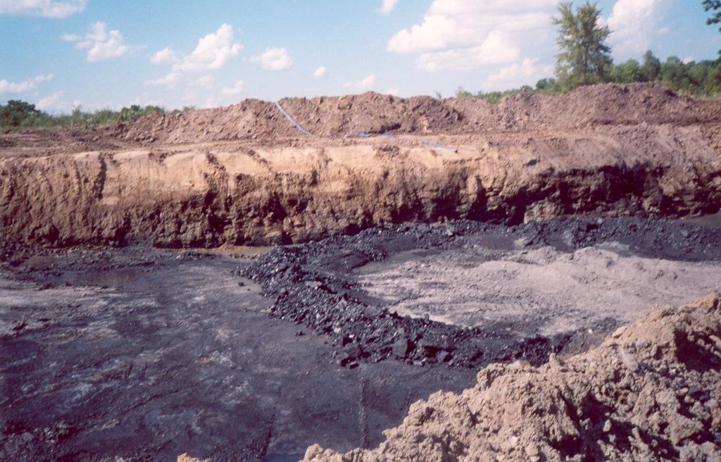
3 LIST OF ILLUSTRATIONS Cover. Metropolis surface coal mine, looking north, showing light gray underclaystone, overlain by the Mineral coal, which is overlain by weathered shale (dark brown where wet in lower part, and beige-tan in upper part) that forms the high-wall and is ft thick. Fig. 1. Route of field trip highlighted on the 2005 Oklahoma State Highway Map, from downtown Oklahoma City to the Metropolis mine, near Eram. Fig. 2. Map showing the distribution of coal resources by county in Oklahoma. (Modified from Friedman, 2003 Keystone Coal Industry Manual). Fig. 3. Skeletal stratigraphic column showing coals of Oklahoma that contain identified quantities of coal resources and unknown quantities of coal-bed methane.(modified from Friedman,2003 Keystone Coal Industry Manual). Fig. 4. Map showing location of the Metropolis surface coal mine and abandoned coal mines in a narrow graben in which the Mineral coal is present near Eram. Fig. 5. Generalized stratigraphic column based upon a cross section by Dunham and Trumbull (1955, plate 22). (Modified from Friedman, 1978). Fig. 6. Aerial photograph showing location of the Metropolis mine in Sec. 1, T. 13 N., R. 14 E., Okmulgee County, Oklahoma. Fig. 7. Generalized stratigraphic column showing the Mineral coal and other key beds in the Senora Formation, Okmulgee County. Fig. 8. Photograph of required sign at entrance to the Metropolis coal mine. Fig. 9. Photo showing orientation of face cleat (with compass) on top of the Mineral coal bed in the Metropolis mine. Fig.10. Map showing face cleat orientation of coal beds of Oklahoma as measured by Friedman and by Hemish in Cardott, 2002 p. 54, fig. 14. Fig.11. Photograph showing pyrite (yellow) and calcite (white) on the face cleat of the Mineral coal bed in the Metropolis mine. Fig.12. SEM photomicrograph of a pyrite framboid from a face-cleat filling. Fig.13. Map showing an area in Okmulgee County in which the Mineral coal or its stratigraphic position is approximately 500 feet or more in depth.

4 1 Fig. 1. Route of field trip on the 2005 Oklahoma State Highway Map, highlighted from downtown Oklahoma City to the Metropolis mine, near Eram.
5 INTRODUCTION PURPOSE The purpose of the field trip to a small surface coal mine is to evaluate the potential for coal-bed methane (CBM) exploration and production of the Mineral coal in Okmulgee County, by examining the coal geology in the mine, with emphasis on the coal bed, and then projecting this geology westward. This guidebook contains a brief sketch of the county s coal geology in relation to other counties in the Northeast Oklahoma Shelf. The route map (Fig. 1) shows that the mine we will visit is 120 miles (a two-hour drive) from downtown Oklahoma City, the location of the present (2005) Biennial Meeting of the AAPG Mid-Continent Section. The mine is 1.5 miles northwest of Eram, Okmulgee County, which is located in the Eastern Sandstone Cuesta Plains subsection of the Sandstone Hills Section (Johnson and others, 1972) of the Central Lowlands Physiographic Province (Fenneman, 1931). COAL GEOLOGY SETTING Approximately 8 billion short tons of identified bituminous coal resources (Table 1) are present in 25 coal beds in 19 counties (Fig. 2) in the Oklahoma coalfield (Friedman, 2003). This coalfield includes about 8,000 square miles and is in the southern part of the Western Region of the Interior Coal Province of the United States (Campbell,1917). The Oklahoma coalfield has been divided into the Arkoma Basin and the Northeast Oklahoma Shelf (Friedman 1974, p. 6 and fig. 5, p. 10). The coal beds, for which coal resources have been determined, occur mostly in the Desmoinesian Series and in part of the Missourian Series of the Pennsylvanian System. The coals are ft thick, contain low sulfur (0.4%) to high sulfur (6.5%),and average 2-3% sulfur by weight. Low- to high-volatile bituminous in rank (ASTM 1994), these coals contain 11,500-14,500 Btu/lb (Friedman, 2003). The thickest coal beds, along with some thin ones, are present in the Arkoma Basin. Thin coal beds are common in the Shelf. Some of these coals may be too thin (< 1 ft thick) and discontinous to consider as good targets for exploration and production for coal-bed methane (CBM). The stratigraphically lower coals are present in the Basin and the higher coals are present in the Shelf (Fig. 3). ACKNOWLEDGMENTS I greatly appreciate the efficient assistance of my wife Evelyn Friedman and my son Aaron Friedman in field work and preparation of this guidebook. Special thanks to Claren Kidd, University of Oklahoma Geology Librarian Emerita, for helpful editorial suggestions. I thank Jim Anderson and Brian Cardott of the Oklahoma Geological Survey (OGS) for their advice and support. I am grateful to Alan Churchill, President of Joshua Coal Co., for enabling us to map and study coal geology at the Metropolis Mine. The Oklahoma City Geological Society paid for the printing and binding (at the OGS) of the unedited copies of this guidebook that were distributed for the field trip. STRATIGRAPHY The Hartshorne, McAlester, Savanna, Boggy, and Calvin formations of the Desmoinesian Series, Pennsylvanian System, are present in the Arkoma Basin. The Boggy is also present in the Northeast Oklahoma Shelf. In the Shelf the Boggy is overlain conformably by the Senora Formation, which is overlain conformably by the Ft.Scott Limestone or the Calvin Sandstone (Friedman, 1974). This guidebook focuses on the Senora Formation and its coal beds in the Shelf, especially in Okmulgee County. THICKNESS AND STRATIGRAPHY OF THE SENORA FORMATION NORTHEAST OKLAHOMA SHELF In 10 counties in the Northeast Oklahoma Shelf the Senora Formation is ft in thickness, contains seven coal beds of which six contained identified coal resources some of which had been 2
.")
6 Table 1. Remaining Identified Bituminous Coal Resources in Oklahoma, January 1, 1999 (from Friedman, S. A., 2003). *Revised in 1986,**Revised in ***Revised in 1994,****Revised in 1998 mined (Friedman, 1974, p. 9, fig. 4). Friedman identified four of the coals--- the Croweburg, Mineral, Morris, and Eram while stating that the Morris in Okmulgee County may be the same as the Mineral in the other counties. A field-trip guidebook (Friedman, 1976) shows that some 300 ft of strata are present in the Senora Formation in parts of Craig, Nowata, and Rogers counties in the Shelf. It also shows surface-mined areas and identified remaining coal resources of three major coals (including the Mineral coal) on a township map. Another map shows mined areas and identified, remaining strippable coal resources of the Croweburg, Morris, and Eram coal beds ft in depth in Okmulgee County (Friedman, 1982, pl. 2). A generalized stratigraphic column indicates that these coals are present in the Senora Formation, which is 300 ft in thickness. Subsequently, detailed stratigraphic mapping indicated that eight coals occur in the Senora Formation, which is ft in thickness. Five of the coals were mined and contained identified remaining resources ft or more in depth in Craig and Nowata counties (Hemish, 1986, p. 8, fig. 4). Mapping farther south showed that the Senora Formation is ft in thickness, contains four out of six coals that were mined and contained identified remaining resources ft or more in depth in Rogers and Mays counties (Hemish, 1989, p. 8-9, fig. 2). Further detailed mapping showed the Senora Formation ft in thickness, including six coals of which four contain identified, remaining resources ft or more in depth in Creek, Washington, Tulsa, and Wagoner counties (Hemish, 1990, pl 1). Thus the Senora thickens, but contains fewer coal beds more than one foot thick, progressively southward in the Northeast Oklahoma Shelf. OKMULGEE COUNTY Dunham and Trumbull (1955, pl. 22) indicated that the Senora Formation increased in thickness from 500 ft in the northern part of Okmulgee County to more than 720 ft in the southern part. These writers assigned the name Morris coal bed to a coal that is less extensive than the Henryetta (Croweburg) coal in the Henryetta Mining District (1955, p. 197). They indicated that the Morris coal cropped out and had been surface mined in the vicinity of Morris, a few miles east of the city of Okmulgee. Forty years later, detailed 7.5 quadrangle mapping in Okmulgee County (Hemish, 1994) showed that the Senora is ft or more in thickness, thus confirming that this formation is thickest in the southern-most part of the Northeast Oklahoma Shelf (Fig. 2). The present writer suggested a research project to determine why the Senora Formation shown on the Oklahoma State Geologic Map (Miser, 1954) extended over an abnormally wide east-west area in Okmulgee County. The result of the project included detailed cross sections with faults bordering tilted half-grabens with vertical displacements from a few ft to almost 450 ft (Hemish, 1988). This 3


7 Location map Fig. 2. Map showing the distribution of coal resources by county in Oklahoma. (Modified from Friedman, 2003 Keystone Coal Industry Manual). 4
8 Fig. 3. Skeletal stratigraphic column showing bituminous coals of Oklahoma that contain identified quantities if coal resources and unknown quantities of coal-bed methane resources (Modified from Friedman, 2003 Keystone Coal Industry Manual). 5
9 Fig. 4. Map showing location of the Metropolis surface coal mine and abandoned coal mines in a narrow graben that is tilted northwestward west of Eram. (Modified from Hemish, 1988). Additional small faults are present parallel or oblique to the major eastern fault in blocks of strata containing pockets of the Mineral coal. In places the Mineral coal bed is 60 feet deep. 6
10 extensional faulting resulted in northeast-trending repetitions of the Senora from Henryetta eastwards to Eram, thus widening its present surface exposure (Hemish 1988). These grabens align with the Seneca faults (graben) (Hemish 1980), and they may be part of a rift system. Just east of Henryetta, again at Morris, and finally near Eram these repetitions of parts of the Senora Formation contain the Mineral coal bed. In the graben area near Eram (Fig. 4) the Mineral coal bed is present in places at depths of 0-60 ft. Thus the Mineral coal bed at Morris was correlated with the Eram coalbed (Hemish, 1988). Previously the Mineral coal bed had been correlated with the coal bed at Morris.(Friedman, 1974, p. 9, fig.4; p. 32; and 1982a). The Senora Formation in Okmulgee County is composed mostly of shale, sandy or silty shale, and sandstone. The Formation also includes other coals that are underlain by underclaystones and are overlain by dark-gray to black shales, which in some places are overlain by thin fossiliferous limestones (Fig. 5). The present writer believes that these lithologically similar sequences each belongs to a separate cyclothem. COAL RESOURCES AND MINING First mined on a commercial scale in 1902, mostly by underground methods, the Henryetta (Croweburg) is the most important coal bed in Okmulgee County (Dunham and Trumbull, 1955). This coal bed contains ~303 million tons of remaining identified coal resources in the county (Hemish, 1994, table 2). The Croweburg may contain CBM resources, but this coal bed is not the focus of this guidebook, which is centered on the Mineral coal bed. Later the present writer will indicate an area in which the Mineral coal bed may contain CBM resources. THE MINERAL COAL BED The Mineral is a high-volatile bituminous coal, high in sulfur (3-6%), ft thick, averaging 1.8 ft in Craig, Nowata, Rogers, Tulsa, and Wagoner counties (Table 2). The Mineral coal is overlain by a thin, hard, impure limestone or gray shale in most places in Craig County. This limestone is absent in most places in Rogers County and is completely absent in Tulsa and Wagoner counties. The Mineral coal bed lies ft below the Croweburg coal bed in Craig, Nowata, and Rogers counties. This interval increases southward to about 100 ft in northern Okmulgee County, and it further increases to approximately 200 ft in the central part of this county (Fig. 5). Most of the mining of the Mineral coal bed in the county has been in the vicinity of Morris, and some has been mined just northwest of Eram (where it is known as the Eram coal) (Fig. 4). Most of the reported production has been by surface mining. Almost 35 million tons of identified remaining coal resources are present in this coal in Okmulgee County (Hemish 1994, table 2). Earlier, Dunham and Trumbull (1955) described the Morris coal as 7-30 inches thick, averaging 16 inches in the Henryetta Mining District (mostly in Okmulgee County). Two small drift mines produced this coal in the 1940s in the vicinity of Morris. The Morris coal was mined by stripping methods in the early 1950s. Later during , this coal was mined by stripping north of Morris, where it is 1-2 ft thick and is high ( %) in sulfur content (Table 2). Shaly limestone, 1-2 inches thick, overlies this coal in small areas in the vicinity of Morris. A small surface mine, north of Morris, uncovered a northeast-trending fault with a 3-foot vertical displacement. In this mine some of the coal contained 3-inch wide vertical fillings of calcite, which greatly increased the ash content, and the operation was closed in This coal was not mined from About 31 million short tons of identified resources of Morris coal has been determined (Friedman 1974). Although adverse geologic and mining conditions are present in the faulted area north of Morris, additional resources of Morris coal are present down dip in other places in Okmulgee County. For example, some 9.7 million tons of Mineral coal occurs at depths greater than 100 ft but less than 500 ft in T. 12 N., R.13 E., in T. 13 N., R E., and in T. 14 N., R. 15 E. (Hemish, 1994, Appendix 1, p. 20, 22, 23, and 25). 7
11 8 Table 2. Table of some standard chemical analyses of the Mineral coal bed. One analysis is from a core sample and the others are from channel samples. All samples were collected by geologists of the Oklahoma Geological Survey, except the USBM sample, which was collected and analyzed by personnell of the U. S. Bureau of Mines. Analyses published in OGS SP 94-3 are from samples collected by L. A. Hemish. The analyses published in OGS SP 74-2 and the one designated as 2005C1F are from samples collected by S. A. Friedman.The analysis designated as OPL 1142 is from a sample collected by B. J. Cardott. The two most recent analyses (2000 and 2005) were done for OGS by Standard Laboratories, Inc., Van Buren, AR.
12 Fig. 5. Generalized stratigraphic column based upon a cross section by Dunham and Trumbull (1955, plate 22). (Modified from Friedman, 1978). 9
13 Approximately 41,000 tons of the Mineral coal bed was surface mined in the Metropolis mine near Eram, Okmulgee County, from November, 1995 through June 30, 2005 by Joshua Coal Co. This small, active mine is the destination of the field trip; it is located in the NE1/4NW1/4NE1/4 sec.1, T. 13 N., R. 14 E. (Fig. 6). In most places in the graben near Eram (Fig. 4), medium light-gray shale that weathers light brown, overlies the coal. In the highwall of the Metropolis mine, medium light-gray shale,12-15 ft thick, overlies the Mineral coal bed, which is 1.5 ft thick (photograph on cover page of guidebook). Light-gray underclaystone, a few inches to a few ft thick, underlies the coal bed in the Metropolis mine and in many places in the county (Figs. 5 and 7). DIRECTIONS TO THE METROPOLIS MINE Going east on I-40, exit at the third exit in the Henryetta vicinity. The second exit leads to the Indian Nations Turnpike that takes you to McAlester---do not take this exit although it is tempting! The third exit should say Okmulgee; it is a clover leaf (270 degree) type of turn that lets you end up going north (on U.S. 75) to Okmulgee and, eventually, to Broken Arrow and Tulsa. Drive about 12 miles to Okmulgee and turn right (east) onto U. S. 62 at a traffic light. Go east to a stop sign in Morris. Notice the new water tower. The old water tower was destroyed by a tornado a few years ago. Continue on U. S. 62 for four miles to County Road 330. If you go too fast and are not watchful you will pass it (as I did). Turn north onto County Road 330. In one mile Pass Watts Road. Slowly go ½ mile farther. Turn east at a bushy tree cluster. See the Joshua Mine sign (Fig. 8). Continue about ½ mile to the mine office, which is in a trailer. Stop. This is a hard hat area by Federal and State rules. Follow the mine operator to the active pit. Take care. CLEAT The dominant vertical fracture system in coal beds is called cleat. There is face cleat and butt cleat. Face cleat are continuous through the coal bed, whereas butt cleat commonly terminate at almost right angles to the face cleat. The cleats are perpendicular to the coal bedding. The face cleat are the primary paths for water and CBM to move through coal beds. Therefore identifying the face cleat and measuring its orientation are important. Face cleat commonly are oriented almost at right angles to the regional structure. Looking down at the top of the coal bed shows the face cleat trending N 23 W (Fig. 9). This orientation conforms to numerous measurements by Friedman and Hemish (Fig. 10) in the Oklahoma coalfield (Cardott, 2002, p. 54, fig. 14). Face cleat commonly contains mineral fillings. A 10- inch- thick sample of the Mineral coal in the Metropolis mine contains (yellow) pyrite and (white) calcite on face cleat (Fig. 11). Although the occurrence of sphalerite (ZnS) in cleat in the Mineral coal causes abnormal concentrations of zinc in the coal bed in places in Craig County (Joe Hatch, U.S.G.S., oral communication, 1983), no sphalerite has been identified in this coal bed in Okmulgee County. Anomalous trace concentrations of lead, zinc, and manganese have been mapped in this coal bed in Craig and Rogers counties (Friedman, 1986), but not in Okmulgee County. A Scanning Electron Microscope (SEM) image (thanks to Bill Chisoe) shows a pyrite framboid (Fig. 12) from a face cleat surface in a sample of an Oklahoma coal bed (collected by the present writer and Kurt T. Hollocher in 1978) from the Arkoma Basin. These and other minerals on face cleat commonly decrease permeability and thus decrease the flow of water and CBM towards a well. COAL-BED METHANE RESOURCES All bituminous coals contain coal-bed methane (CBM) that develops during thermal coalification (maturation). Some coals also contain some biogenic methane. Coal beds 500-2,000 ft in depth contain 77% of the CBM resources in the Arkoma Basin (Iannaccione and Puglio, 1979). At least 3 trillion cubic ft of CBM has been estimated to be present in only five of the principal coals in this Basin (Rieke and Kirr, 1984). Other coals undoubtedly contain CBM in the Basin and in the 10
 to determine CBM resources in some parts of the Arkoma Basin (Friedman, 1982), but not in the Shelf area.")
14 Shelf areas in Oklahoma (Figs. 2 and 3). Probably coal beds at the same depth range (500-2,000 ft) contain the greatest quantity of CBM in the Shelf. The present writer previously had applied this depth range (500-2,000 ft) to determine CBM resources in some parts of the Arkoma Basin (Friedman, 1982), but not in the Shelf area. Coal resources for the Mineral (Eram) have been determined (Friedman, 1974, Hemish, 1994) for depths much less than 500 ft, but not for depths from 500-2,000 ft in Okmulgee County, which is in the southernmost part of the Shelf area. In the absence of reliable geologic coal resource estimates, reliable geologic estimates of CBM resources have not been determined and published. Rte 330 Mine road ft Watts Road Google Fig. 6. Aerial photograph showing location of the Metropolis mine in Sec. 1, T. 13 N., R. 14 E., Okmulgee County, Oklahoma. 11
15 Fig. 7. Generalized stratigraphic column showing the Mineral coal and other key beds in the Senora Formation, Okmulgee County. 12

16 Fig. 8. Photograph of required sign at entrance to the Metropolis coal mine. Phone number and address have been deleted by computer by the present writer for security. 13
 on top of the Mineral coal bed")
17 Fig. 9. Photograph, looking down, showing N. 23 NW. orientation of the face cleat (with compass) on top of the Mineral coal bed in the Metropolis mine. 14
18 Fig.10. Map showing face cleat orientation of coal beds in the Oklahoma coal field as measured by Friedman and by Hemish in Cardott, 2002, p. 54, fig. 14. The orientation symbol east of the Y in Okmulgee County represents the cleat orientation shown in Fig. 9). 15

19 Fig.11. Photograph showing pyrite (yellow) and calcite (white) on the face cleat of the Mineral coal bed in the Metropolis mine. Only 10 inches of the total thickness of the coal bed is shown. The butt cleat is oriented almost 90 to the face cleat. Both cleats are perpendicular to the bedding. 16
 photomicrograph of a pyrite framboid from a face-cleat filling,")
20 Fig.12. Scanning electron microscope (SEM) photomicrograph of a pyrite framboid from a face-cleat filling, collected by S. A. Friedman and Kurt T. Hollocher from a coal bed in LeFlore County, Oklahoma in
21 COALBED METHANE PRODUCTION Annual CBM production accounts for 3 percent of the total annual natural gas production in Oklahoma (D. Boyd, personal communication). Approximately 79 billion cubic ft (Bcf) of CBM has been produced from wells in the Arkoma Basin from (Cardott, 2005, p. 79). A total of 45 billion Bcf of methane from coal beds has been produced from 844 CBM wells in the Northeast Oklahoma Shelf from (Cardott, 2005). Companies have reported 1,577 wells completed in CBM in 13 coal beds in 7 counties in the Shelf. Companies also have reported the majority of completions in the Riverton, Rowe, Weir-Pittsburg, Mulky, and Iron Post (Ft. Scott) coal beds, averaging 31,000 cubic ft (31Mcf) per day per well of initial production of CBM (Cardott, 2005). Oklahoma Corporation Commission records indicate that only a few CBM wells have been completed through 2003 in Okmulgee County, and they were in the western and northern-most part of the county. One well was reported to have penetrated the Mineral coal at ft in depth in sec. 3, T.14 N., R.13 E. It was completed on 1/21/2002 as D & A (dry and abandoned). This location is just east of the area in which the Mineral coal is projected to lie 500 ft in depth (Fig 13). Production data is uncertain for the few other completed wells. POTENTIAL COAL-BED METHANE PRODUC- TION FROM THE MINERAL COAL BED The Mineral coal bed if present in the faulted northeast-trending grabens between Henryetta and Eram is most likely too shallow to contain significant CBM resources. On the other hand, and based upon previous studies (Friedman, 1974 and Hemish, 1994) Okmulgee County has approximately 10,000 acres that contain 31 million short tons of the Mineral coal, which is 101-1,000 ft deep, inches thick, and high-volatile bituminous in rank. If one assumes that only one half of these acres contain the Mineral coal bed at depths from 500-1,000 ft, then only 15.5 million tons of coal is present in the area shown in Fig. 13. This is not the ideal depth range in which high-volatile bituminous coal contains the maximum CBM. Nevertheless, a conservative estimate, employing the original U. S. Bureau of Mines standard (Iannacchione and Puglio, 1979), indicates that approximately 3,100,000,000 cubic ft of CBM resources are present in this coal bed in this county, assuming that a minimum of 200 cubic ft of CBM is present per ton of coal. Fig.13. Map showing an area (gray) in Okmulgee County in which the Mineral coal or its stratigraphic position is approximately 500 ft or more in depth. The coal bed increases in depth northwestward, down dip. 18
22 References Cited American Society for Testing and Materials (ASTM), 1994, Annual book of standards, section 5, v , p , D388-92a. Campbell, M. R., 1917 (1922), The Coal Fields of the United States: U.S. Geological Survey Prof. Paper 200-A, 33 p., 3 figs., 1 plate. (Introduction). Cardott, B. J., 2002, Introduction to coal geology of Oklahoma in B. J. Cardott, compiler, Fourth annual Oklahoma coalbed-methane workshop: Oklahoma Geological Survey Open-File Report , p. 54, fig. 14. Cardott, B. J., 2005, Coalbed-methane activity in Oklahoma, 2004 update: Oklahoma Geological Survey Circular 110, p Dunham, R. J. and Trumbull, J. V. A., 1955, Geology and coal resources of the Henryetta Mining District, Okmulgee County, Oklahoma: U.S. Geological Survey Bull F, p , 5 figs., 4 plates. Fenneman, N.M., 1931, Physiography of western United States: New York, McGraw-Hill Book Co. Friedman, S. A., 1974, Investigation of the coal reserves in the Ozarks section of Oklahoma and their potential uses: Final report to the Ozarks Regional Commission, July 1974: Oklahoma Geological Survey Special Publication SP 74-2 (5th printing, 1981), 117 p., 24 figs., 20 tables, 1 appendix. 1976, Coal geology of parts of Craig, Nowata, and Rogers counties, Oklahoma in R. W. Scott (ed.), Coal and oil potential of the Tri-State area: Tulsa Geological Society Field Trip [Guidebook] p , Desmoinesian coal deposits in part of the Arkoma Basin, eastern Oklahoma: Oklahoma City Geological Society Guidebook for Field Trip 2 of the American Association of Petroleum Geologists Annual Meeting, 62 p., 24 figs., 3 tables. 1982a, Map showing potentially strippable coal beds in eastern Oklahoma: Oklahoma Geological Survey Map GM 23 (4 sheets) (scale 1:125,000). 1982b, Determination of reserves of methane from coal beds for use in rural communities in eastern Oklahoma: Oklahoma Geological Survey Special Publication SP 82-3, 32 p., 7 figs., 2 tables, (2nd printing, 1989). 1986, A geochemical study of bituminous coal resources of Middle Pennsylvanian Age in eastern Oklahoma: Part 1 - Maps showing distribution of fixed carbon, sulfur, and lead, zinc, and manganese, in Garbini, Susan, and S. P. Schweinfurth (eds.), Symposium Proceedings: A national agenda for coal quality research, April 9-11, 1985: U.S. Geological Survey Circular 979, p (abs.). 2003, Oklahoma Coal Geology in 2003 Keystone Coal Industry Manual, Chicago, Primedia Business Magazines, p , 3 figs., 2 tables. Hemish, L. A., 1986, Coal geology of Craig County and eastern Nowata County, Oklahoma: Oklahoma Geological Survey Bulletin 140, 131 p., 17 figs., 8 plates, 2 tables, 4 appendixes. 1988, A stratigraphic and structural study of the Eram coal and associated strata in eastern Okmulgee County and western Muskogee County, Oklahoma: Oklahoma Geological Survey Map GM-30, text and 8 plates (map scale 1:31,680). 1989, Coal geology of Rogers County and western Mayes County, Oklahoma: Oklahoma Geological Survey Bulletin 144, 118 p., 12 figs., 8 plates, 2 tables , Coal geology of Tulsa, Wagoner, Creek, and Washington counties, Oklahoma: Oklahoma Geological Survey Geologic Map GM 33, text and 5 plates on 3 sheets (scale 1:63,360). 1994, Coal geology of Okmulgee County and eastern Okfuskee County, Oklahoma (with a map [plate] showing abandoned underground coal mines by Samuel A. Friedman): Oklahoma Geological Survey Special Publication 94-3, 86 p., 9 figs., 8 plates, 2 tables, 4 appendices. Iannacchione, A. T., and Puglio, D. G., 1979, Methane content and geology of the Hartshorne coal bed in Haskell and Le Flore counties, Oklahoma: U.S. Bureau of Mines Report. of Investigations RP 8407, 14 p., 11 figs., 3 tables. Johnson, K.S., Branson, C.C., Curtis, N.M., Jr., Ham, W.E., Marcher, M.V., and Roberts, J.F., 1972, Geology and earth resources of Oklahoma-an atlas of maps and cross sections: Oklahoma Geological Survey Educational Publication 1. Miser, H. D., and others, 1954, Geologic map of Oklahoma: U. S. Geological Survey, 2 sheets, scale 1:500,000. Rieke, H.H. and Kirr, J.N., 1984, Geologic overview, coal and coalbed methane resources of the Illinois Basin Arkansas and Oklahoma, in C.T. Rightmire, G.E. Eddy, and J.N. Kirr, (eds.) Coalbed Methane resources of the United States, American Association of Petroleum Geologists Studies in Geology Series [No.] 17, p
Issues Related to Oklahoma Coalbed- Methane Activity,
 Figure 1. Map of the eastern Oklahoma coalfield (modified from Friedman, 1974). Issues Related to Oklahoma Coalbed- Methane Activity, 1988 2008 Brian J. Cardott Oklahoma Geological Survey INTRODUCTION
Chapter Three: Coalbed Gas in the Cherokee Basin
 Chapter Three: Coalbed Gas in the Cherokee Basin The first test in Kansas to assess coalbed gas potential in southeastern Kansas was from several wells drilled during the late 1980 s in Wilson and Montgomery
Oklahoma Geological Survey Oklahoma Coal Database ANALYTICAL HEADER TABLE DOCUMENTATION
 Oklahoma Geological Survey Oklahoma Coal Database ANALYTICAL HEADER TABLE DOCUMENTATION Point ID Data point identification number: the system is tied to location and is intended to provide a unique identifier
CoalBed Methane Fact and Future In Oklahoma
 OKLAHOMA CORPORATION COMMISSION Oil and Gas Conservation Division CoalBed Methane Fact and Future In Oklahoma November 24 Jamal Daneshfar, PE Out Lines:. Fact and figures about Coal bed methane. Regulation
0708 Carbon Sequestration and Enhanced Coalbed Methane Recovery Potential of the Cahaba and Coosa Coalfields in the Southern Appalachian Thrust Belt
 0708 Carbon Sequestration and Enhanced Coalbed Methane Recovery Potential of the Cahaba and Coosa Coalfields in the Southern Appalachian Thrust Belt M. R. McIntyre and J. C. Pashin Geological Survey of
MESOZOIC BASINS. North Carolina Geological Survey
 MESOZOIC BASINS North Carolina Geological Survey The 1823 organic act which created the North Carolina Geological Survey (NCGS) tasked us to examine, describe and map the geology, geologic hazards, and
KRIS wsbssm. IBHiiilll
 KRIS wsbssm IBHiiilll Digitized by the Internet Archive in 2012 with funding from University of Illinois Urbana-Champaign http://archive.org/details/engineeringaspec34ekbl STATE OF ILLINOIS HENRY HORNER,
CHAPTER 4: COALBED GAS IN THE BOURBON ARCH
 138 CHAPTER 4: COALBED GAS IN THE BOURBON ARCH 139 4.1 Introduction The Bourbon arch of eastern Kansas is a mature petroleum province with conventional hydrocarbon production in the declining stages over
Platt s 22 nd Annual Coal Properties And Investment
 Platt s 22 nd Annual Coal Properties And Investment Demand and Production of Thermal and Met Coal Palm Beach Gardens, Florida March 17 18, 2014 Alan K. Stagg Stagg Resource Consultants, Inc. U.S Metallurgical
Valley-Fill Sandstones in the Kootenai Formation on the Crow Indian Reservation, South-Central Montana
 DE-FG22-96BC14996--08 Valley-Fill Sandstones in the Kootenai Formation on the Crow Indian Reservation, South-Central Montana Quarterly Report April 1 - June 30, 1998 By David A. Lopez Work Performed Under
SL GEOLOGY AND MINING. Coal bearing strata in the project area are referable primarily to the Allegheny Group of
 SL-145-1 GEOLOGY AND MINING Coal bearing strata in the project area are referable primarily to the Allegheny Group of Pennsylvania age. These rocks occur as dissected remnants overlying the ridge-forming
CHAPTER 3: COAL-BEARING INTERVALS OF THE BOURBON ARCH
 68 CHAPTER 3: COAL-BEARING INTERVALS OF THE BOURBON ARCH 69 3.1 Introduction The examination of Desmoinesian coal-bearing intervals includes: 1) facies successions and their associated well-log characteristics;
THE STRUCTURE AND THICKNESS OF THE CLINTON AND BEREA FORMATIONS IN THE VICINITY OF WOOSTER, OHIO
 THE STRUCTURE AND THICKNESS OF THE CLINTON AND BEREA FORMATIONS IN THE VICINITY OF WOOSTER, OHIO KARL VER STEEG College of Wooster INTRODUCTION AND ACKNOWLEDGMENTS The data used in the construction of
Natural Gas Assessment of the Arkoma Basin, Ouachita Thrust Belt, and Reelfoot Rift Introduction & Methodology Overview
 Natural Gas Assessment of the Arkoma Basin, Ouachita Thrust Belt, and Reelfoot Rift Introduction & Methodology Overview Upper Atoka incised channel deposit at Ozark, Arkansas Dave Houseknecht U.S. Department
Bibliography of Oklahoma Coal Brian J. Cardott Oklahoma Geological Survey
 Bibliography of Oklahoma Coal Brian J. Cardott Oklahoma Geological Survey Agbe-Davies, V.F., 1979, The geology of the Hartshorne coals in the Spiro and Hackett quadrangles, LeFlore County, Oklahoma (abstract):
Atlantic Rim Coalbed Methane Play: The Newest SuccessfulCBM Play in the Rockies
 Atlantic Rim Coalbed Methane Play: The Newest SuccessfulCBM Play in the Rockies Robert A. Lamarre Lamarre Geological, Denver, Colorado Stephen K. Ruhl Anadarko Petroleum Corporation, The Woodlands, Texas
Cretaceous, Dakota Formation, Terra Cotta Member South Side of I-70, Salina County, Kansas
 Cretaceous, Dakota Formation, Terra Cotta Member South Side of I-70, Salina County, Kansas Written By: Steven D.J. Baumann G-102010-1A Outcrop looking southeast Photo taken by: Steven Baumann on 10-20-2010
Challenge of Mae Sot Oil Shale Exploration in Thailand (In the First Phase, 2008) Apichart Jeennagol Apiradee Suwannathong
 Apichart Jeennagol Apiradee Suwannathong") Challenge of Mae Sot Oil Shale Exploration in Thailand (In the First Phase, 2008) by Apichart Jeennagol Apiradee Suwannathong The 28 th Oil Shale Symposium October 15, 2008 Colorado School of Mines, Golden,
Challenge of Mae Sot Oil Shale Exploration in Thailand (In the First Phase, 2008) by Apichart Jeennagol Apiradee Suwannathong The 28 th Oil Shale Symposium October 15, 2008 Colorado School of Mines, Golden,
Lower Skinner Valley Fill Sandstones: Attractive Exploration Targets on the Northeast Oklahoma Platform*
 Lower Skinner Valley Fill Sandstones: Attractive Exploration Targets on the Northeast Oklahoma Platform* By Jim Puckette 1 Search and Discovery Article #10050 (2003) *Adapted from presentation to Tulsa
Module 10: Resources and Virginia Geology Topic 4 Content: Virginia Geology Notes
 Virginia is composed of a very diverse landscape that extends from the beaches and barrier islands all of the way to the highly elevated Appalachian Plateau. Geologists have discovered ancient shallow
B.C. s Offshore Oil and Gas: a Guide to the Geology and Resources.
 B.C. s Offshore Oil and Gas: a Guide to the Geology and Resources. Introduction Beneath the offshore regions of British Columbia are four moderately large, geologically young sedimentary basins (Figure
IVANHOE COMMENCES RESOURCE DELINEATION DRILLING AT NARIIN SUKHAIT COAL PROJECT IN MONGOLIA S SOUTH GOBI
 January 12, 2005 IVANHOE COMMENCES RESOURCE DELINEATION DRILLING AT NARIIN SUKHAIT COAL PROJECT IN MONGOLIA S SOUTH GOBI ULAANBAATAR, MONGOLIA Ivanhoe Mines Chairman Robert Friedland and President John
Stratigraphy and Hydrocarbon Production from Pennsylvanian Age Granite Wash Reservoirs in the Western Anadarko Basin, Oklahoma and Texas
 Stratigraphy and Hydrocarbon Production from Pennsylvanian Age Granite Wash Reservoirs in the Western Anadarko Basin, Oklahoma and Texas John Mitchell, Managing Partner/Consulting Geologist Fall River
Sequence Stratigraphy of the Upper Cretaceous Niobrara Formation, A Bench, Wattenberg Field, Denver Julesburg Basin, Colorado*
 Sequence Stratigraphy of the Upper Cretaceous Niobrara Formation, A Bench, Wattenberg Field, Denver Julesburg Basin, Colorado* Lisa E. Remington LaChance 1 and Mark C. Robinson 1 Search and Discovery Article
Curriculum Support Maps for the Study of Indiana Coal
 Curriculum Support Maps for the Study of Indiana Coal By Walt Gray Targeted Age: High School/Middle School Activity Structure: Individual Assignment or Group Project Indiana Standards and Objectives: E.S.
DIRECTORY OF COAL MINES IN ILLINOIS
 DIRECTORY OF COAL MINES IN ILLINOIS Champaign County This directory accompanies the Illinois Coal Mines map or maps for this County. August 2018 Prairie Research Institute Illinois State Geological Survey
Nemaha Strike-Slip Fault Expression on 3-D Seismic Data in SCOOP Trend
 Nemaha Strike-Slip Fault Expression on 3-D Seismic Data in SCOOP Trend June 2018 Satinder Chopra, Kurt Marfurt, Folarin Kolawole, Brett M. Carpenter Fthe meaningful recognition of the faults within the
Regional Trends in Coalbed Gas Composition and Thermal Maturation in Eastern Kansas: Implications for Predicting Quality and Location of Coalbed Gas
 Regional Trends in Coalbed Gas Composition and Thermal Maturation in Eastern Kansas: Implications for Predicting Quality and Location of Coalbed Gas K. David Newell and L. Michael Magnuson Kansas Geological
Seismic Stratigraphy of the Fang Basin, Chiang Mai, Thailand Rungsun Nuntajun
 Chiang Mai J. Sci. 2009; 36(1) 77 Chiang Mai J. Sci. 2009; 36(1) : 77-82 www.science.cmu.ac.th/journal-science/josci.html Contributed Paper Seismic Stratigraphy of the Fang Basin, Chiang Mai, Thailand
DIRECTORY OF COAL MINES IN ILLINOIS 7.5-MINUTE QUADRANGLE SERIES KINSMAN QUADRANGLE GRUNDY & LASALLE COUNTIES. Jennifer M. Obrad
 DIRECTORY OF COAL MINES IN ILLINOIS 7.5-MINUTE QUADRANGLE SERIES KINSMAN QUADRANGLE GRUNDY & LASALLE COUNTIES Jennifer M. Obrad Department of Natural Resources ILLINOIS STATE GEOLOGICAL SURVEY 2006 DIRECTORY
Overview of Selected Shale Plays in New Mexico*
 Overview of Selected Shale Plays in New Mexico* Ron Broadhead 1 Search and Discovery Article #10627 (2014)** Posted August 18, 2014 *Adapted from presentation at RMAG luncheon meeting, Denver, Colorado,
GEOLOGY AND MINERAL RESOURCES OF INDIAN RESERVE 26
 ) 41HI3NW94I4 I R NO 26 1*A1 MANITOULIN ISLAND 010 -f?;. GEOLOGY AND MINERAL RESOURCES OF INDIAN RESERVE 26 September 16, 1975 D. G. Innes, Resident Geologist Sudbury District Ministry of Natural Resources
'!lill[ flinii]i^,e. isfsv. 0G,c *'- SURVEY
!['!lill[ flinii]i^,e. isfsv. 0G,c *'- SURVEY](/thumbs/89/99050466.jpg "'!lill[ flinii]i^,e. isfsv. 0G,c *'- SURVEY") '!lill[ flinii]i^,e isfsv 0G,c *'- SURVEY 3 3051 00005 8770 ' ILLINOIS GEOLOGICAL SURVEY LIBRARY OCT 24 1357 r \ ILLINOIS STATE GEOLOGICAL SURVEY / i Urbana, Illinois John C. Frye, Chief \lllinois INDUSTRIAL
'!lill[ flinii]i^,e isfsv 0G,c *'- SURVEY 3 3051 00005 8770 ' ILLINOIS GEOLOGICAL SURVEY LIBRARY OCT 24 1357 r \ ILLINOIS STATE GEOLOGICAL SURVEY / i Urbana, Illinois John C. Frye, Chief \lllinois INDUSTRIAL
DIRECTORY OF COAL MINES IN ILLINOIS
 DIRECTORY OF COAL MINES IN ILLINOIS Marion County This directory accompanies the Illinois Coal Mines map or maps for this County. August 2018 Prairie Research Institute Illinois State Geological Survey
Search and Discovery Article #41255 (2014)** Posted February 11, 2014
** Posted February 11, 2014") Correlating Porosity with Acoustic Impedance in Sandstone Gas Reservoirs: Examples from the Atokan Sandstones of the Arkoma Basin, Southeastern Oklahoma* Ibrahim Çemen 1, Jeff Fuchs 1, Bill Coffey 2, Rodney
Correlating Porosity with Acoustic Impedance in Sandstone Gas Reservoirs: Examples from the Atokan Sandstones of the Arkoma Basin, Southeastern Oklahoma* Ibrahim Çemen 1, Jeff Fuchs 1, Bill Coffey 2, Rodney
Overview of Unconventional Energy Resources of Oklahoma
 Overview of Unconventional Energy Resources of Oklahoma By Brian J. Cardott (Oklahoma Geological Survey) Presented at OGS Conference on Unconventional Energy Resources in the Southern Midcontinent in Oklahoma
DIRECTORY OF COAL MINES IN ILLINOIS 7.5-MINUTE QUADRANGLE SERIES MAZON QUADRANGLE GRUNDY COUNTY. Jennifer M. Obrad
 DIRECTORY OF COAL MINES IN ILLINOIS 7.5-MINUTE QUADRANGLE SERIES MAZON QUADRANGLE GRUNDY COUNTY Jennifer M. Obrad Department of Natural Resources ILLINOIS STATE GEOLOGICAL SURVEY 2006 DIRECTORY OF COAL
IP 121 ILLINOIS PETROLEUJM Illinois Institute of Natdral Resources STATE GEOWGICA SURVEY DIVISION' Jack A. Simon. Chief
 IP 121 ILLINOIS PETROLEUJM 121 1981 Illinois Institute of Natdral Resources STATE GEOWGICA SURVEY DIVISION' Jack A. Simon. Chief Stevenson, D. L. (David L.) Geologic structure of the base of the New Albany
Stromatoporoids around the Georgetown, Kentucky area
 Stromatoporoids around the Georgetown, Kentucky area If you have ever visited and / or travelled around the area of Georgetown, Scott County, Kentucky you might have noted white watermelon shaped rocks
The Problem of the Welden, Sycamore and Lower Caney in the Eastern Arbuckle Mountains
 120 PROC. OF THE OKLA. ACAD. OF SCI. FOR 1958 The Problem of the Welden, Sycamore and Lower Caney in the Eastern Arbuckle Mountains STEVE C. CHAMPLIN, University of Oklahoma, Norman This paper is a preliminary
The Geology of Two Lights State Park. Cape Elizabeth, Maine
 Maine Geologic Facts and Localities June, 2002 Cape Elizabeth, Maine 43 33 33.48 N, 70 12 13.32 W Text by Henry N. Berry IV and Robert G. Marvinney, Department of Agriculture, Conservation & Forestry 1
ENGLE COAL FIELD. David E. Tabet
 OPEN FILE REPORT 115 SUMMARY OF THE GEOLOGY OF THE ENGLE COAL FIELD by David E. Tabet THE ENGLE COAL FIELD Introduction The Engle coal field (Lee, 1905), named for the small town of Engle along the Santa
DIRECTORY OF COAL MINES IN ILLINOIS 7.5-MINUTE QUADRANGLE SERIES BROADWELL QUADRANGLE LOGAN COUNTY. Margaret H. Bargh
 DIRECTORY OF COAL MINES IN ILLINOIS 7.5-MINUTE QUADRANGLE SERIES BROADWELL QUADRANGLE LOGAN COUNTY Margaret H. Bargh Department of Natural Resources ILLINOIS STATE GEOLOGICAL SURVEY 1994 REVISED 2009 DIRECTORY
DIRECTORY OF COAL MINES IN ILLINOIS 7.5-MINUTE QUADRANGLE SERIES PRAIRIETOWN QUADRANGLE MADISON COUNTY. Cheri Chenoweth & Andrew Louchios
 DIRECTORY OF COAL MINES IN ILLINOIS 7.5-MINUTE QUADRANGLE SERIES PRAIRIETOWN QUADRANGLE MADISON COUNTY Cheri Chenoweth & Andrew Louchios Department of Natural Resources ILLINOIS STATE GEOLOGICAL SURVEY
Dr. Kenneth B. Taylor, P.G.
 North Carolina Forestry Association 2013 Annual Meeting October 3, 2013 Shale Gas 101: Natural Gas Exploration / Development: A North Carolina Perspective presented by Dr. Kenneth B. Taylor, P.G. State
Resource Classification Systems by Dan Alexander
 Resource Classification Systems by Dan Alexander EIA US Coal Reserves: 1997 Update SME Working Party #79, 1992 USGS Geologic Survey Circular 891, 1983 USBM/USGS Circular 831, 1980 SEC Securities Act of
DIRECTORY OF COAL MINES IN ILLINOIS
 DIRECTORY OF COAL MINES IN ILLINOIS Hamilton County This directory accompanies the Illinois Coal Mines map or maps for this County. August 2017 Prairie Research Institute Illinois State Geological Survey
DIRECTORY OF COAL MINES IN ILLINOIS
 DIRECTORY OF COAL MINES IN ILLINOIS Pope County This directory accompanies the Illinois Coal Mines map or maps for this County. August 2018 Prairie Research Institute Illinois State Geological Survey 615
Plan of Development Mountain Valley Pipeline Project. APPENDIX P Plan for Unanticipated Discovery of Paleontological Resources
 APPENDIX P Plan for Unanticipated Discovery of Paleontological Resources Appendix P Plan for Unanticipated Discovery of Paleontological Resources Prepared by: TABLE OF CONTENTS 1.0 INTRODUCTION... 1 1.1
DIRECTORY OF COAL MINES IN ILLINOIS 7.5-MINUTE QUADRANGLE SERIES KEENSBURG QUADRANGLE WABASH COUNTY
 DIRECTORY OF COAL MINES IN ILLINOIS 7.5-MINUTE QUADRANGLE SERIES KEENSBURG QUADRANGLE WABASH COUNTY Alan R. Myers & C. Chenoweth 2012 Prairie Research Institute William W. Shilts, Executive Director ILLINOIS
Field Trip 1 Tunnel Mill, Vernon, Indiana: Waldron Shale
 Geol G308 Paleontology and Geology of Indiana Name: Field Trip 1 Tunnel Mill, Vernon, Indiana: Waldron Shale On this trip we will visit Tunnel Mill, which is located just south of Vernon, Indiana in the
Using Thermal Maturity to Identify the Most Productive Part of the Oil Window to Target in the Woodford Shale
 2 nd Annual Woodford Liquids-Rich January 28, 2015 Horizontal Targets Congress 2015 Using Thermal Maturity to Identify the Most Productive Part of the Oil Window to Target in the Woodford Shale Brian J.
Glassy Rock Perlite Mine, Bristol Mountains, San Bernardino County, California
 Glassy Rock Perlite Mine, Bristol Mountains, San Bernardino County, California Gregg Wilkerson 2017 Acknowledgement and Disclaimer The information in this paper is taken largely from published sources.
WEIR INTERNATIONAL, INC. Mining, Geology and Energy Consultants
 WEIR INTERNATIONAL, INC. Mining, Geology and Energy Consultants Introduction to Coal Mining History of Coal in the United States Coal was one of man s earliest sources of heat and light Coal was first
DIRECTORY OF COAL MINES IN ILLINOIS 7.5-MINUTE QUADRANGLE SERIES MT. PULASKI QUADRANGLE LOGAN COUNTY. G. K. Coats M. H. Bargh C. G.
 DIRECTORY OF COAL MINES IN ILLINOIS 7.5-MINUTE QUADRANGLE SERIES MT. PULASKI QUADRANGLE LOGAN COUNTY G. K. Coats M. H. Bargh C. G. Treworgy Department of Natural Resources ILLINOIS STATE GEOLOGICAL SURVEY
FRACTURE TRACES AND PRODUCTIVITY OF MUNICIPAL WELLS IN THE MADISON LIMESTONE, RAPID CITY, SOUTH DAKOTA
 Proceedings of the South Dakota Academy of Science, Vol. 87 (2008) 261 FRACTURE TRACES AND PRODUCTIVITY OF MUNICIPAL WELLS IN THE MADISON LIMESTONE, RAPID CITY, SOUTH DAKOTA Perry H. Rahn Department of
Amboy Iron Mines, Bristol Mountains, San Bernardino County, California. Gregg Wilkerson 2017
 Amboy Iron Mines, Bristol Mountains, San Bernardino County, California Gregg Wilkerson 2017 Acknowledgement and Disclaimer The information in this paper is taken largely from published sources. I have
NOA ASSESSMENT HARRIS QUARRY MENDOCINO COUNTY, CALIFORNIA TABLE OF CONTENTS
 NOA ASSESSMENT HARRIS QUARRY MENDOCINO COUNTY, CALIFORNIA TABLE OF CONTENTS Introduction... 1 Scope of Services... 1 Project Location and Description... 1 Geologic Setting... 1 Regional Geology... 1 Site
The McCully gas field in southern New Brunswick was discovered in the year 2000 on a joint drilling exploration venture by Corridor Resources Inc.
 1 The McCully gas field in southern New Brunswick was discovered in the year 2000 on a joint drilling exploration venture by Corridor Resources Inc. and Potash Corporation of Saskatchewan. Located about
Steve Cumella 1. Search and Discovery Article # (2009) Posted July 30, Abstract
 Posted July 30, Abstract") AV Geology of the Piceance Basin Mesaverde Gas Accumulation* Steve Cumella 1 Search and Discovery Article #110106 (2009) Posted July 30, 2009 *Adapted from oral presentation at AAPG Annual Convention,
AV Geology of the Piceance Basin Mesaverde Gas Accumulation* Steve Cumella 1 Search and Discovery Article #110106 (2009) Posted July 30, 2009 *Adapted from oral presentation at AAPG Annual Convention,
SOUTHWEST & NORTHWEST EXPLORATION PROJECTS BINGHAM CANYON MINING DISTRICT
 SOUTHWEST & NORTHWEST EXPLORATION PROJECTS BINGHAM CANYON MINING DISTRICT SALT LAKE AND TOOELE COUNTIES, UTAH SUMMARY FRIDAY, MARCH 20, 2009 1 Tooele County Salt Lake County GOOGLE EARTH September, 2006
What s Shaking in the Barnett Shale? STEP Dallas, August 11, 2015
 What s Shaking in the Barnett Shale? STEP Dallas, August 11, 2015 BSEEC.org @BSEEC Barnett Shale Facts The Barnett Shale was the first energy shale to be developed and therefore is the birthplace of the
QUINTETTE COAL LIMITED 1979 EXPLORATION ASSESSMENT REPORT
 QUINTETTE COAL LIMITED 1979 EXPLORATION ASSESSMENT REPORT JANUARY 1980 TABLE OF CONTENTS 1.0 Introduction 1.1 Geological Mapping 1.2 Field Camp 2.0 Geology 2.1 Introduction 2.2 Stratigraphy 2.3 Structure
Downloaded 03/27/18 to Redistribution subject to SEG license or copyright; see Terms of Use at
 Calibrating seismic fracture prediction using borehole image logs, application to the Mississippian Limestone Stephanie Cook*, Abdulmohsen Alali, Kurt J. Marfurt, Matthew J. Pranter The University of Oklahoma
DIRECTORY OF COAL MINES IN ILLINOIS 7.5-MINUTE QUADRANGLE SERIES NIANTIC QUADRANGLE MACON COUNTY. Cheri Chenoweth & Andrew Louchios
 DIRECTORY OF COAL MINES IN ILLINOIS 7.5-MINUTE QUADRANGLE SERIES NIANTIC QUADRANGLE MACON COUNTY Cheri Chenoweth & Andrew Louchios Department of Natural Resources ILLINOIS STATE GEOLOGICAL SURVEY 2004
Your web browser (Safari 7) is out of date. For more security, comfort and the best experience on this site: Update your browser Ignore
 is out of date. For more security, comfort and the best experience on this site: Update your browser Ignore") Your web browser (Safari 7) is out of date. For more security, comfort and the best experience on this site: Update your browser Ignore BEDRO CK For the complete encyclopedic entry with media resources,
Your web browser (Safari 7) is out of date. For more security, comfort and the best experience on this site: Update your browser Ignore BEDRO CK For the complete encyclopedic entry with media resources,
DIRECTORY OF COAL MINES IN ILLINOIS 7.5-MINUTE QUADRANGLE SERIES PAWNEE QUADRANGLE CHRISTIAN, SANGAMON & MONTGOMERY COUNTIES
 DIRECTORY OF COAL MINES IN ILLINOIS 7.5-MINUTE QUADRANGLE SERIES PAWNEE QUADRANGLE CHRISTIAN, SANGAMON & MONTGOMERY COUNTIES Alan R. Myers & C. Chenoweth Department of Natural Resources ILLINOIS STATE
3D Modeling of the Santa Terezinha Coalfield, Brazil - implications for estimation of the CBM potential
 3D Modeling of the Santa Terezinha Coalfield, Brazil - implications for estimation of the CBM potential H. Burger, R. Prissang 1, M. Holz and W. Kalkreuth 2 1 Institut für Geologische Wissenschaften, FU
Robert S. Sawin Stratigraphic Research Section Kansas Geological Survey. Open-File Report
 Copies of Archived Correspondence Pertinent to the Decision to Classify the Exposure at Point of Rocks, Morton County, Kansas, as Jurassic by the Kansas Geological Survey in 1967 Robert S. Sawin Stratigraphic
!'f \, w. Alan Stewart Colorado Exploration Company, Golden STRUCTURE OF THE FOOTHILLS AREA WEST OF DENVER, COLORADO. Introduction
 STRUCTURE OF THE FOOTHLLS AREA WEST OF DENVER, COLORADO w. Alan Stewart Colorado Exploration Company, Golden ntroduction i ; The dominant structural features west of Denver and along the mountain front
Geology of the RC Westfork Cemetery Ridge Solution Collapse Breccia, Viburnum Trend, Southeast Missouri. By Thomas Schott
 Geology of the RC Westfork Cemetery Ridge Solution Collapse Breccia, Viburnum Trend, Southeast Missouri By Thomas Schott Introduction Viburnum Trend Pb-Zn mineralization is blind Historically poor results
Structural Styles and Geotectonic Elements in Northwestern Mississippi: Interpreted from Gravity, Magnetic, and Proprietary 2D Seismic Data
 Structural Styles and Geotectonic Elements in Northwestern Mississippi: Interpreted from Gravity, Magnetic, and Proprietary 2D Seismic Data Nick Loundagin 1 and Gary L. Kinsland 2 1 6573 W. Euclid Pl.,
The Impact of Parasequence Stacking Patterns on Vertical Connectivity Between Wave-Dominated, Shallow Marine Parasequences, Book Cliffs, Eastern Utah
 The Impact of Parasequence Stacking Patterns on Vertical Connectivity Between Wave-Dominated, Shallow Marine Parasequences, Book Cliffs, Eastern Utah MALCOLM J. ARNOT and TIMOTHY R. GOOD* MALCOLM J. ARNOT
DIRECTORY OF COAL MINES IN ILLINOIS 7.5-MINUTE QUADRANGLE SERIES BRUSSELS QUADRANGLE & portions of KAMPVILLE QUADRANGLE, CALHOUN COUNTY
 DIRECTORY OF COAL MINES IN ILLINOIS 7.5-MINUTE QUADRANGLE SERIES BRUSSELS QUADRANGLE & portions of KAMPVILLE QUADRANGLE, CALHOUN COUNTY Alan R. Myers & C. Chenoweth 2010 Institute of Natural Resource Sustainability
Big Rivers Electric Corporation Disposal of Coal Combustion Residuals (CCR) from Electric Utilities Final Rule CCR Impoundment Liner Assessment Report
 from Electric Utilities Final Rule CCR Impoundment Liner Assessment Report") Big Rivers Electric Corporation Disposal of Coal Combustion Residuals (CCR) from Electric Utilities Final Rule CCR Impoundment Liner Assessment Report CCR Surface Impoundment Information Name: Operator:
Big Rivers Electric Corporation Disposal of Coal Combustion Residuals (CCR) from Electric Utilities Final Rule CCR Impoundment Liner Assessment Report CCR Surface Impoundment Information Name: Operator:
New Mexico Geological Society
 New Mexico Geological Society Downloaded from: http://nmgs.nmt.edu/publications/guidebooks/9 Summary of coal resources of the Black Mesa coal field, Arizona R. B. O'Sullivan, 1958, pp. 169-171 in: Black
DIRECTORY OF COAL MINES IN ILLINOIS 7.5-MINUTE QUADRANGLE SERIES SORENTO SOUTH QUADRANGLE BOND & MONTGOMERY COUNTIES
 DIRECTORY OF COAL MINES IN ILLINOIS 7.5-MINUTE QUADRANGLE SERIES SORENTO SOUTH QUADRANGLE BOND & MONTGOMERY COUNTIES Jennifer M. Obrad 2013 Prairie Research Institute William W. Shilts, Executive Director
Structural Deformation and Karst in the Devonian Waterways Formation: Examples from Outcrops along the Athabasca River*
 Structural Deformation and Karst in the Devonian Waterways Formation: Examples from Outcrops along the Athabasca River* Chris L. Schneider 1 and Matthias Grobe 2 Search and Discovery Article #51073 (2015)
Using Map and Compass Together
 Using Map and Compass Together In situations where you foresee a potential evacuation on foot, where there are no roads, and no indication as to the direction of travel (i.e., road signs), it is recommended
The Bedrock Geology of Mount Battie, Camden, Maine
 Maine Geologic Facts and Localities July, 2001, Maine 44 13 15.40 N, 69 4 5.10 W Text by Henry N. Berry IV, Department of Agriculture, Conservation & Forestry 1 Photo by Henry N. Berry IV Introduction
THE NEW HARMONY GROUP (LOWER DEVONIAN)
") 2001. Proceedings of the Indiana Academy of Science 1 10:23-27 THE NEW HARMONY GROUP (LOWER DEVONIAN) REVISITED 1 John B. Droste and Alan S. Horowitz Department of Geological Sciences, Indiana : University,
2001. Proceedings of the Indiana Academy of Science 1 10:23-27 THE NEW HARMONY GROUP (LOWER DEVONIAN) REVISITED 1 John B. Droste and Alan S. Horowitz Department of Geological Sciences, Indiana : University,
AAPG European Region Annual Conference Paris-Malmaison, France November RESOURCES PERSPECTIVES of the SOUTHERN PERMIAN BASIN AREA
 AAPG European Region Annual Conference Paris-Malmaison, France 23-24 November 2009 RESOURCES PERSPECTIVES of the SOUTHERN PERMIAN BASIN AREA J.C. DOORNENBAL, TNO Built, Environment and Geosciences, Geological
Cape Breton Island Mineral Inventory Studies: A Sandstone Quarry Development Opportunity at Graham River (NTS 11F/14), Inverness County
, Inverness County") Report of Activities 2001 23 Cape Breton Island Mineral Inventory Studies: A Sandstone Quarry Development Opportunity at Graham River (NTS 11F/14), Inverness County G. J. DeMont and J. E. Hawken Compilation
Report of Activities 2001 23 Cape Breton Island Mineral Inventory Studies: A Sandstone Quarry Development Opportunity at Graham River (NTS 11F/14), Inverness County G. J. DeMont and J. E. Hawken Compilation
Michael G. McClure. Current Position. Profession. Significant Projects. Years' Experience. Education. Specific Projects. Professional Registrations
 Michael G. McClure Current Position Principal Geologist Profession Geology Years' Experience 39+ Education MS - Geology, University of Kentucky, Lexington, KY BS - Geology, Brigham Young University, Provo,
DIRECTORY OF COAL MINES IN ILLINOIS 7.5-MINUTE QUADRANGLE SERIES WOOD RIVER QUADRANGLE MADISON COUNTY Cheri Chenoweth & Melony E.
 DIRECTORY OF COAL MINES IN ILLINOIS 7.5-MINUTE QUADRANGLE SERIES WOOD RIVER QUADRANGLE MADISON COUNTY Cheri Chenoweth & Melony E. Barrett Department of Natural Resources ILLINOIS STATE GEOLOGICAL SURVEY
GPR AS A COST EFFECTIVE BEDROCK MAPPING TOOL FOR LARGE AREAS. Abstract
 GPR AS A COST EFFECTIVE BEDROCK MAPPING TOOL FOR LARGE AREAS Dr. Jutta L. Hager, Hager GeoScience, Inc., Waltham, MA Mario Carnevale, Hager GeoScience, Inc., Waltham, MA Abstract Hager GeoScience, Inc.
Hydrogeology of East-Central Union County, Northeastern New Mexico
 Hydrogeology of East-Central Union County, Northeastern New Mexico Geoffrey Rawling April 2013 New Mexico Bureau of Geology & Mineral Resources 1 What are the important hydrogeologic issues in Union County?
REPORT OF GEOLOGICAL MAPPING ON THE MICHEL COAL LICENSE #5177. LOCATION: KOOTENAY LAND DISTRICT NTS 82-G-7 4Y028 Lat f Long.
 i *. REPORT OF GEOLOGICAL MAPPING ON THE MICHEL COAL LICENSE #5177 LOCATION: KOOTENAY LAND DISTRICT NTS 82-G-7 4Y028 Lat. 114 40f Long. ESSO RESOURCES CANADA LIMITED WARD E. KILBY WORK: OCTOBER 17 - OCTOBER
DIRECTORY OF COAL MINES IN ILLINOIS 7.5-MINUTE QUADRANGLE SERIES TAYLORVILLE QUADRANGLE CHRISTIAN COUNTY. Jennifer M. Obrad
 DIRECTORY OF COAL MINES IN ILLINOIS 7.5-MINUTE QUADRANGLE SERIES TAYLORVILLE QUADRANGLE CHRISTIAN COUNTY Jennifer M. Obrad Department of Natural Resources ILLINOIS STATE GEOLOGICAL SURVEY 2007 DIRECTORY
BEFORE THE CORPORATION COMMISSION OF THE STATE OF OKLAHOMA OPERATING LLC LOCATION EXCEPTION. Report of the Administrative Law Judge
 n APPLICANT: BEFORE THE CORPORATION COMMISSION OF THE STATE OF OKLAHOMA RELIEF SOUGHT BILLY JACK SHARBER OPERATING LLC LOCATION EXCEPTION LEGAL DESCRIPTION NW/4 SE/4 OF SECTION 29, TOWNSHIP NORTH, RANGE
QUANTITY, MARCH 1962
 BASE-FLOW STUDIES, GUADALUPE RIVER COMAL COUNTY, TEXAS QUANTITY, MARCH 1962 TEXAS WATER COMMISSION BULLETIN 6503 MARCH 1965 TEXAS WATER COMMISSION Joe William D E 0. F. Dent Carter, Chairman Berger, Commissioner
PREDICTION OF ACID MINE DRAINAGE POTENTIAL FROM COAL MINES
 PREDICTION OF ACID MINE DRAINAGE POTENTIAL FROM COAL MINES Arthur W. Rose, Professor of Geochemistry Eugene G. Williams, Professor of Geology Richard R. Parizek, Professor of Hydrogeology Acid mine drainage
P.R. SPRING AND HILL CREEK TAR SAND AREAS A RESOURCE ASSESSMENT (IN PROGRESS)
") P.R. SPRING AND HILL CREEK TAR SAND AREAS A RESOURCE ASSESSMENT (IN PROGRESS) presented by WALLY GWYNN - Utah Geological Survey at the Western U.S. Oil Sands Technology Transfer Meeting February 22, 2008
P.R. SPRING AND HILL CREEK TAR SAND AREAS A RESOURCE ASSESSMENT (IN PROGRESS) presented by WALLY GWYNN - Utah Geological Survey at the Western U.S. Oil Sands Technology Transfer Meeting February 22, 2008
For Sale - 56 Acre Sandstone Quarry State Route 511, Oberlin/Kipton, OH 44075
 14647 State Route 511, Oberlin/Kipton, OH 44075 56 ACRES Vermilion Rd Gifford Rd Haigh Rd 44 Summary The Kipton sandstone quarry is included in 56 acre tract owned by Terry A. Johnson, of Huron, Ohio.
ALASKA GEOLOGICAL SOCIETY PUBLICATIONS Stratigraphic And Structure Sections
 ALASKA GEOLOGICAL SOCIETY PUBLICATIONS 2007-2008 Stratigraphic And Structure Sections Price Western Alaska Bristol Bay Region Stratigraphic Correlation Sections (CD)... $12.00 AGS Member Price... $10.00
Downloaded 10/10/13 to Redistribution subject to SEG license or copyright; see Terms of Use at
 Characterizing a fault-zone and associated fractures using lab experiments and attribute-based seismic analysis: an example from Woodford Shale, Anadarko basin, Oklahoma Zonghu Liao*, Ze ev Reches, and
N. J. Macala. C ONTENT S. LIST OF PLATES.
 REPORT ON WATER SUikLY AT MANBULLOO STATION, NORTHERN TERRITORY. by N. J. Macala. Records 1957/62. C ONTENT S. Page. Introduction. 1. General Geology, 1. Hydrology. 1. New Bore Sites Selected. 2. Reference.
CARTER METALLURGICAL COAL PROJECT. Endurance Gold Corporation (EDG)
") CARTER METALLURGICAL COAL PROJECT McDOWELL COUNTY, WEST VIRGINIA Endurance Gold Corporation (EDG) Endurance Resources Inc. (ERI) Prepared by: Duncan McIvor, President and CEO Endurance Gold Corporation
CARTER METALLURGICAL COAL PROJECT McDOWELL COUNTY, WEST VIRGINIA Endurance Gold Corporation (EDG) Endurance Resources Inc. (ERI) Prepared by: Duncan McIvor, President and CEO Endurance Gold Corporation
Petroleum Systems (Part One) Source, Generation, and Migration
 Source, Generation, and Migration") Petroleum Systems (Part One) Source, Generation, and Migration GEOL 4233 Class January 2008 Petroleum Systems Elements Source Rock Migration Route Reservoir Rock Seal Rock Trap Processes Generation Migration
Petroleum Systems (Part One) Source, Generation, and Migration GEOL 4233 Class January 2008 Petroleum Systems Elements Source Rock Migration Route Reservoir Rock Seal Rock Trap Processes Generation Migration
LONG LAKE ZINC MINE. Selected References "Zinc and Lead Deposits of Canada'% Geol. Surv. Can., Econ. Geol. Series, No k 8, 1930, pp, H6-151.
 April,1952 31CI8NW8eie 63.3149 OLDEN 010 ^ LONG LAKE ZINC MINE Selected References Alcock, P.J., "Zinc and Lead Deposits of Canada'% Geol. Surv. Can., Econ. Geol. Series, No k 8, 1930, pp, H6-151. Harding,