CASE STUDY ON THE REMEDIATION OF WATER INGRESS TO OLD GOLD WORKINGS LINKED TO ACTIVE MINING AREAS IN SOUTH AFRICA 1
|
|
|
- April Davis
- 6 years ago
- Views:
Transcription
1 CASE STUDY ON THE REMEDIATION OF WATER INGRESS TO OLD GOLD WORKINGS LINKED TO ACTIVE MINING AREAS IN SOUTH AFRICA 1 Mike Palmer 2, Chris Waygood, Irene Lea Abstract. Grootvlei Mine is located in the Far East Rand Basin, part of the Witwatersrand Basin, which has been actively mined for over 100 years. In order to maintain access to its reserves, Grootvlei dewaters approximately 75 Ml/day from its workings. The water is treated and discharged to the Blesbokspruit. A portion of the water pumped from underground is believed to originate from surface water. Technical assessments to identify the areas of ingress, quantities of ingress and possible measures to reduce the ingress are the subject of this paper. In addition, progress made with remediation works on one identified ingress area is discussed. The remedial works are being carried out by Grootvlei Mine, with partial funding provided by the Council for Geoscience. The site represents a difficult working environment due to the very wet conditions resulting from historical roadway construction and tailings spills. 1 Paper presented at the 7 th International Conference on Acid Rock Drainage (ICARD), March 26-30, 2006, St. Louis MO. R.I. Barnhisel (ed.) Published by the American Society of Mining and Reclamation (ASMR), 3134 Montavesta Road, Lexington, KY Mike Palmer is an associate at Jones & Wagener (Pty) Ltd, Consulting Civil Engineers, Gauteng, South Africa. Chris Waygood is a director of Jones & Wagener. Irene Lea is a geohydrologist, and is Environmental Officer for the Petrex operations in South Africa. 1483
2 Introduction Grootvlei Proprietary Mines (Pty) Ltd is a subsidiary of Petrex (Pty) Ltd and is the last remaining operational gold mine in the East Rand Basin of the Witwatersrand gold fields. Mining in the East Rand Basin has been ongoing over the last 80 years, and the basin is now largely mined out. The Mine is located in South Africa s Gauteng province, approximately 25 km east of Johannesburg. The mining area is shown in Fig. 1. Grootvlei Mine currently dewaters approximately 75 Ml/day from its workings in order to maintain access to the underground reserves. Water is pumped from the No. 3 shaft, with the pump station located at a depth of approximately 740 m below surface. The water is treated via a High Density Separation (HDS) process including aeration and addition of lime to remove primarily iron, where after it is discharged to a river known as the Blesbokspruit, which flows over the East Rand Basin. This discharge is in line with the conditions of the existing water use license, issued by the Department of Water Affairs and Forestry (DWAF). A proportion of the water pumped from underground is believed to originate from surface water. A high proportion of the flow in the Blesbokspruit is the result of industrial discharges, primarily from four sewage treatment plants and a paper mill. An investigation was carried out to identify methods by which to reduce the volumes of water required to be pumped from underground (Jones & Wagener, 2003). The first phase of remediation works recommended by the investigation is currently being carried out. Ingress Investigation Numerous previous studies (most notably Scott (1995) Barradas and Loggenberg (1996), Petmin (2000) and Wates Meiring & Barnard (2002), all cited in Jones & Wagener (2003)) had been carried out on the ingress of water at Grootvlei, indicating a strong possibility that a significant proportion of the water originated from surface water. In addition, a large proportion of the flow in the Blesbokspruit comprises industrial flows (some 205 Ml/day, compared with 68 Ml/day natural flows). It is therefore not unreasonable to assume that reducing the flow in the Blesbokspruit would significantly reduce the recharge to the East Rand Basin. Based on this, a previous investigation suggested the construction of a canal, 35 km long, to remove the industrial flows from the river, with an estimated 50% reduction in ingress volumes. However, the ingress volumes show strong seasonality, with summer inflow rates being almost double those in winter, with a lag of 1 to 2 months. The industrial flows, on the other hand, are largely constant. Field studies showed the presence of significant clay alluvium along the Blesbokspruit, which would be expected to limit recharge volumes from surface and result in a lag of longer than 1 to 2 months. In addition, mining personnel indicated that inflows appear to be significantly higher in areas of shallow undermining than deeper areas. Removal of the industrial flows would also not reduce ponding over much of the catchment, since the ponding is attributed to existing dams and areas where culverts and road structures have resulted in silting and damming of flows, as illustrated in Fig. 2 and 3. This was seen as a major drawback of the canal proposal, in that after construction, significant problem areas would still remain in terms of surface recharge, and the estimated 50% reduction in ingress appeared highly optimistic. 1484
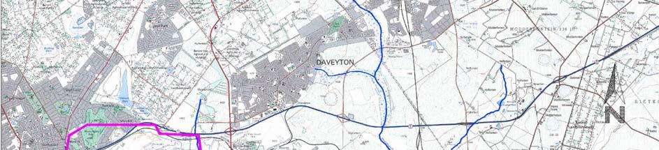


3 JOHANNESBURG SOUTH AFRICA Figure 1. Grootvlei Mine locality plan 1485


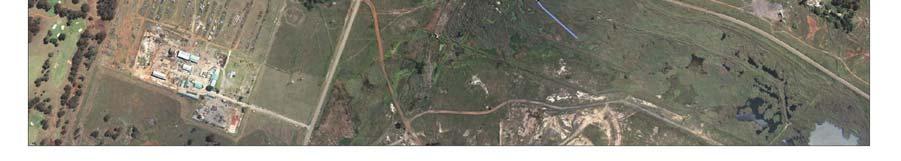
4 Figure 2. Ponding at West Pit Figure 3. Ponding in the southern Blesbokspruit It was therefore decided to focus on identifying all potential recharge mechanisms for the East Rand Basin and to quantify as far as possible the contribution of each mechanism to the surface water ingress into the basin. From this it would be possible to identify, evaluate and cost a range of remedial options for reducing the volume of surface water recharge. Investigational Work A conceptual groundwater model was required to gain an understanding of the primary mechanisms of ingress into the basin. The following assessments were carried out to enable the development of a model: Basin geology. The geology of the basin and its influence on recharge to the workings was considered. Seasonality of ingress. Pumping rates do not necessarily correlate with inflows if the water levels underground are not constant and pumping rates vary depending on electricity costs, maintenance and other factors. Historical pumping, water level and rainfall data were obtained. The water level data were used to calculate storage volumes underground using a digital terrain model (dtm) of the reef within the East Rand Basin and shareholders plans of the mined out areas. An average stoping width of 2 m was applied to calculate the mined out volume, although stoping widths do vary significantly, and are often narrower. Ingress volumes could then be calculated and the seasonality determined. The fluctuation of the calculated ingress in relation to rainfall is illustrated in Fig. 4. Photo survey. An aerial survey of the catchment was conducted. The Blesbokspruit was also photographed over the length of the Petrex mining area to assess the current status in terms of historical problems identified by Barradas and Loggenberg (cited in Jones & Wagener, 2003) and the impact of other developments such as roads, tailings dams and tailings reclamation activities. The impact of road construction with related silting and ponding was evident from the aerial photographs, as illustrated in Fig. 2 and 3. Delineation of areas of shallow undermining. Observations by mining personnel indicated that any mining shallower than approximately 300 m from surface is characterised by significantly increased groundwater inflows. These areas were therefore targeted as high risk areas requiring further investigation. 1486
5 Rainfall in relation to the ingress experienced since August Ingress in Ml/day Rainfall in mm Aug-00 Sep-00 Oct-00 Nov-00 Dec-00 Jan-01 Feb-01 Mar-01 Apr-01 May-01 Jun-01 Jul-01 Aug-01 Sep-01 Oct-01 Nov-01 Dec-01 Month Average ingress (Ml/day) Rainfall 4 per. Mov. Avg. (Rainfall) Figure 4. Relationship between rainfall and ingress volume. Jan-02 Feb-02 Mar-02 Apr-02 May-02 Jun-02 Jul-02 Aug-02 Sep-02 Oct-02 Nov-02 Dec-02 Jan-03 Feb-03 Alluvium survey. A survey was undertaken along the Blesbokspruit to assess the depth of alluvial clays, using hand auguring and information from previous investigations. It was found that alluvial clays are present to depths of at least 1.5 m in most instances. In addition, there are extensive silt deposits of up to several metres depth at some culverts and bridges. Flow measurements. Flow rates were measured underground at areas where inflows could be associated with shallow workings or a particular geological feature. Surface flow measurements were also undertaken upstream and downstream of areas of potential ingress, using in-stream hand held equipment. The surface measurements proved to be problematic given the low flow rates and the wide wetland areas, as well as ad-hoc pumping from and to the streams by industry in the area. Isotope study. Measurement of nitrogen isotopes was used to assess whether a link exists between the industrial discharge (primarily treated sewage water, thus high in nitrates) and the underground recharge. Although the results are based on a single sampling run only, and are subject to validation by further testing, the study provided strong evidence of a link. Conceptual Modelling Ground water modelling usually implies analysis of groundwater flow volumes using two primary concepts, namely Darcy s Law (momentum balance) and conservation of mass. From these simple approaches, a host of mathematical computations can be undertaken to determine inflows or outflows within a particular environment for which the flow characteristics and extent are known


6 Where this is not possible due to limited available data, or the complexity of the area, the problem can be simplified by considering broad areas or components for which a particular recharge or flow is either assumed or determined from analysis or interpretation of field data. To a large degree, the second approach was followed in this study, based on the extent to which information was available to allow a meaningful assessment. As with any multiparameter model, it is possible to simulate the observed ingress by assigning incorrect recharge rates to the various components. However, within the bounds of accepted or substantiated possible recharge values, the conceptual model provides an indication of the likely contributions and the extent to which mitigation measures may be successful in reducing the inflows. Each area of ingress was assessed, and the components of the conceptual groundwater balance are summarised below. Main Reef outcrop where mining has extended to surface. Where the Main Reef outcrops on surface, surface and shallow mining has caused subsidence along the outcrop area (Fig. 5 and 6). There are two main ingress mechanisms associated with this component of the water balance. The first is ingress via direct rainfall, and its contribution was calculated by taking average rainfall over an assumed 10 m wide zone along the exposed outcrop. The second mechanism is surface runoff, where surface outcrop areas intersect stream beds. The contribution of surface runoff was determined by estimating runoff volumes and measuring the catchment area of each exposed outcrop zone. Figure 5. Old access shafts on outcrop Figure 6. Stoping on Main Reef outcrop Sub-outcrop where shallow undermining has taken place. The ingress to areas of mining shallower than 300 m was quantified using accessible areas where flows could be measured, and extrapolated to the remaining shallow areas. Structural features. Structural features tend to be the main conduit for recharge from the overlying dolomitic aquifer. One fault in particular, referred to by mine personnel as the rain forest is situated below Cowles Dam (refer to Fig. 1). The flow along this fault has been measured and is estimated to potentially contribute as much as 10 Ml/day. Recharge from the southern Blesbokspruit wetland area. Apart from one potential area of shallow undermining and the possibility of the Cowles Dam fault extending south into the Blesbokspruit wetlands, the risk of high surface water recharge in this area was considered low, given the depth of mining and the presence of Karoo geology overlying the dolomitic aquifer. 1488
7 Overlying dolomitic aquifer. Experience has shown that the base of the dolomites is generally very impermeable and inflow to the mine workings from the dolomitic aquifer is restricted to geological features linking the two. The inflow from the dolomites is, however, significant and is expected to be relatively constant, particularly where karstification has been accelerated in the exposed areas of dolomite around the Blesbokspruit. The inflow from this source was calculated by measuring the area of exposed dolomite and applying a recharge rate of 15% of mean annual precipitation. This is considered to be within an acceptable range, based on past experience and previous studies. Flooded defunct coal mine. The Largo Mine is a defunct, flooded coal mine situated to the east of Grootvlei and adjacent to the Blesbokspruit. The area is characterised by surface subsidence. The extent to which this mine interacts with the dolomitic aquifer and influences the recharge to Grootvlei is the subject of further investigation. Modelling results The estimated recharge for each component is indicated in Table 1. Table 1. Groundwater recharge components. Recharge Component Average flow rate (Ml/day) Wet Season Dry Season Catchment recharge into outcrop Direct recharge via outcrop Shallow undermining Preferential recharge (geological structures) Recharge via dolomitic aquifer Total A sensitivity analysis was conducted to indicate the parameters having the greatest influence on the water balance. The analysis indicated that the model is most sensitive to the dolomite ingress, this being the dominant source of ingress. During the wet season, the model is also sensitive to the runoff volume and subsequent surface water influx through direct inflows via the outcrop into shallow mining areas. The model indicated that the primary sources of surface water ingress are related to the outcrop and shallow undermining areas. Further modelling work was commissioned by the Council for Geoscience (CGS), also to assess the surface water contribution to the ingress in the East Rand Basin. The work was carried out by Africa Geo-Environmental Services (AGES) and involved the compilation of a finite element model of the East Rand Basin, accounting for all possible sources of inflow to the underground workings. This work indicated that 65% (or 48 Ml/day) of the ingress to the East Rand Basin originates from surface water. 1489
8 The modelling also calculated the ingress at West Pit (identified as an area of shallow undermining with high potential ingress, discussed later) to be in the order of 5,5 Ml/day, or 12% of the average ingress from surface water. Should remedial works prevent all ingress at West Pit, the overall dewatering rate could be reduced by approximately 7% (AGES, 2005). Proposed remediation options Based on the outcome of the modelling, it was decided to focus the initial remediation measures on the outcrop areas and the areas of shallow undermining. In the dry outcrop areas, situated to the north (refer to Fig. 7), the extent of faulting makes it difficult to plug the holings. However, much of this area is currently being re-mined opencast, and will be rehabilitated as part of the mining process. Rehabilitation of the remaining areas will be considered once mining has ceased. There are a number of areas of shallow undermining, most notably adjacent to Grootvlei s West Pit, an opencast pit adjacent to the stream (Fig. 2 and 7). The flow in the stream constitutes largely surface runoff, with the industrial flows amounting to some 22 Ml/day. Underground mining in this area is extremely shallow, being only 7 m below surface in places. Significant underground seepage is experienced in this area, estimated to be up to 10 Ml/day. A large quantity of silt (mostly in the form of gold tailings) has been deposited upstream of the road culvert, and appears to cover most of the footprint of the wetland. It is considered important to improve the drainage in this area to minimise the extent of ponded water, as simply diverting the industrial flows around the area is not expected to significantly reduce the ponding. The strategy proposed for this area is to divert low flows around the wetland and to improve the drainage by opening up the downstream road and railway culverts, allowing the area to dry. This would be followed by removal of the tailings, and revegetation of the area. Further areas of shallow undermining have been indicated in the south eastern parts of the East Rand Basin, where the Blesbokspruit forms a wide wetland area. However, these areas have not been noted by mine personnel as areas of significant recharge, and have still to be investigated further. The rehabilitation of the West Pit area was therefore selected as the first phase of the remedial works. Remediation at West Pit The shallow mining adjacent to West Pit is covered by a wide wetland area that has been created by a combination of environmentally poor road and railway construction, flat slopes and tailings washing from old tailings dams into the stream. 1490
9 Figure 7. Location of Main Reef outcrop and West Pit 1491
10 Scope of work At the time of writing, construction was underway on the remedial works adjacent to West Pit. The works involve the following (refer to Fig. 8): Construction of a weir across the wetland to direct the industrial flows and runoff up to the 1:5 year event into a low flow canal around the western side of the wetland. The low flow canal will be separated from the floodplain area by a berm, and will direct these flows under the roadway via a new culvert. The existing culvert will be opened up and the original stream will be reinstated, while the area of ponding will be allowed to dry out. Once the area has drained, the exposed tailings will be removed. The area will then be revegetated and maintained to prevent the growth of large stands of reeds. Over the area with the highest risk of ingress, the length of low flow canal will be lined with concrete to minimise seepage. The end result is expected to be an open, grassed area which is only inundated during extreme events, with the low flows restricted to a dedicated canal, where the width over which possible ingress can occur is significantly reduced. The expected cost of the work is US$ 1.55 million (2005). Challenges encountered Difficult working conditions on site have presented both the consultant and the contractor with a number of challenges since construction began. Access to waterlogged areas. Very soft ground conditions have made access to the waterlogged areas difficult. In order to gain access it is necessary to construct rockfill platforms into the wetland area. A woven geotextile has been used as a support layer beneath the rockfill material. This measure has proved highly successful, with minimal loss of material. Depth of tailings. Initially, the depth of the tailings in the area was determined by hand augering, and estimated to be up to 1,5 m thick. During construction the tailings thickness was found to be significantly greater, causing concerns about invert levels, and the ability to effectively drain the area, given the extremely flat longitudinal slope on this portion of the stream. Flat slopes. The flat longitudinal slope (in the region of 1:1000) has resulted in large scale silting, not only in the area of concern, but also downstream of the road and railway. It was therefore necessary to excavate a canal downstream of the area to provide a direct drainage route to the main watercourse, thus facilitating drainage of the West Pit area. The entire downstream canal is located within a wetland area, with soft, wet conditions underfoot, requiring the construction of a rockfill access road on woven geotextile. The flat slopes mean that this canal will always be prone to silting, and maintenance will be required to keep it open and to prevent excessive reed growth. 1492


11 Figure 8. Remedial works at West Pit 1493
12 Conclusions From the investigations it was concluded that a significant portion (up to 65%) of the ingress to the East Rand Basin originates from surface water. The majority of this water appears to originate from ingress at the open holings and subsidence areas at the Main Reef outcrop, as well as from areas of shallow undermining. The current rehabilitation will only address one area of shallow undermining. Modelling has shown that this could reduce the required pumping rate by up to 7%. This will be evaluated once the rehabilitation work is completed. While the works will improve the flow past West Pit, the reduction in ponding is also partially dependent on the downstream areas being able to drain effectively. Regular maintenance on the downstream canal will be required to keep it clear and maintain the flow. Further investigation is required at all the remaining identified areas to confirm both the ingress volumes and the mechanisms of ingress. References Africa Geo-Environmental Services (Pty) Ltd Conceptual groundwater flow model of the Far East Rand Basin Grootvlei sub-catchment. Phase 1. AGES Technical Report No. AS/R/05/01/24. Prepared for Council for Geoscience and Ferret Mining (Pty) Ltd. Barradas & Loggenberg Investigation of Surface Water Ingress to the East Rand Basin. Jones & Wagener (Pty) Ltd Grootvlei Proprietary Mines (Pty) Ltd, a subsidiary of Petrex (Pty) Ltd: Feasibility study on the reduction of surface water inflows to the underground workings. Jones & Wagener Report No. JW101/03/8894. Petmin Strategic Water Management Plan Integration with the Entire Basin. Scott Flooding of Central and East Rand Gold Mines. An Investigation into Controls over the Inflow Rate, Water Quality and Predicted Impacts of Flooded Mines. WRC Report No. 486/1/95. Wates, Meiring & Barnard Integrated Water Management Plan, Geohydrological Investigation. Prepared for Sappi Enstra. 1494
Technical Note: Hydrology of the Lukanga Swamp, Zambia
 Technical Note: Hydrology of the Lukanga Swamp, Zambia Matthew McCartney July 7 Description The Lukanga swamp is located approximately 5km west of the city of Kabwe, in the Central province of Zambia,
Sedimentation in the Nile River
 Advanced Training Workshop on Reservoir Sedimentation Sedimentation in the Nile River Prof. Dr. Abdalla Abdelsalam Ahmed 10-16 Oct. 2007, IRTCES, Beijing, China CWR,Sudan 1 Water is essential for mankind
Illinois State Water Survey Division
 Illinois State Water Survey Division SURFACE WATER SECTION SWS Miscellaneous Publication 108 SEDIMENT YIELD AND ACCUMULATION IN THE LOWER CACHE RIVER by Misganaw Demissie Champaign, Illinois June 1989
HYDROGEOLOGICAL PROPERTIES OF THE UG2 PYROXENITE AQUIFERS OF THE BUSHVELD COMPLEX
 R. Gebrekristos, P.Cheshire HYDROGEOLOGICAL PROPERTIES OF THE UG2 PYROXENITE AQUIFERS OF THE BUSHVELD COMPLEX R. Gebrekristos Digby Wells Environmental P. Cheshire Groundwater Monitoring Services Abstract
Chiang Rai Province CC Threat overview AAS1109 Mekong ARCC
 Chiang Rai Province CC Threat overview AAS1109 Mekong ARCC This threat overview relies on projections of future climate change in the Mekong Basin for the period 2045-2069 compared to a baseline of 1980-2005.
A BOOKLET ON. T Rangasamy, A R Leach and A P Cook. Facilitating safety and health research in the South African mining industry
 A BOOKLET ON THE HYDRAULIC DESIGN OF COAL BARRIER PILLARS T Rangasamy, A R Leach and A P Cook Facilitating safety and health research in the South African mining industry A BOOKLET ON THE HYDRAULIC DESIGN
REDWOOD VALLEY SUBAREA
 Independent Science Review Panel Conceptual Model of Watershed Hydrology, Surface Water and Groundwater Interactions and Stream Ecology for the Russian River Watershed Appendices A-1 APPENDIX A A-2 REDWOOD
Gully Erosion Part 1 GULLY EROSION AND ITS CAUSES. Introduction. The mechanics of gully erosion
 Gully Erosion Part 1 GULLY EROSION AND ITS CAUSES Gully erosion A complex of processes whereby the removal of soil is characterised by incised channels in the landscape. NSW Soil Conservation Service,
A Report on a Statistical Model to Forecast Seasonal Inflows to Cowichan Lake
 A Report on a Statistical Model to Forecast Seasonal Inflows to Cowichan Lake Prepared by: Allan Chapman, MSc, PGeo Hydrologist, Chapman Geoscience Ltd., and Former Head, BC River Forecast Centre Victoria
HISTORY OF CONSTRUCTION FOR EXISTING CCR SURFACE IMPOUNDMENT PLANT GASTON ASH POND 40 CFR (c)(1)(i) (xii)
(1)(i) (xii)") HISTORY OF CONSTRUCTION FOR EXISTING CCR SURFACE IMPOUNDMENT PLANT GASTON ASH POND 40 CFR 257.73(c)(1)(i) (xii) (i) Site Name and Ownership Information: Site Name: E.C. Gaston Steam Plant Site Location:
HISTORY OF CONSTRUCTION FOR EXISTING CCR SURFACE IMPOUNDMENT PLANT GASTON ASH POND 40 CFR 257.73(c)(1)(i) (xii) (i) Site Name and Ownership Information: Site Name: E.C. Gaston Steam Plant Site Location:
 5.2 APPENDIX D2 Geotechnical Report Jeffares & Green: 03524: Ilinge and Lesseyton Cemetery Development ILINGE AND LESSEYTON CEMETERY DEVELOPMENT - GEOTECHNICAL INVESTIGATION FINAL REPORT SEPTEMBER 2014
CASE STUDY BINGA, PHILIPPINES
 SEDIMENT MANAGEMENT CASE STUDY BINGA, PHILIPPINES Key project features Name: Binga Country: Philippines Category: modify operating rule (focus or redistribute sediment); adaptive strategies Binga hydropower
[1] Performance of the sediment trap depends on the type of outlet structure and the settling pond surface area.
![[1] Performance of the sediment trap depends on the type of outlet structure and the settling pond surface area.](/thumbs/76/74245181.jpg "[1] Performance of the sediment trap depends on the type of outlet structure and the settling pond surface area.") Sediment Trench SEDIMENT CONTROL TECHNIQUE Type 1 System Sheet Flow Sandy Soils Type 2 System [1] Concentrated Flow Clayey Soils Type 3 System [1] Supplementary Trap Dispersive Soils [1] Performance of
Sediment Trench SEDIMENT CONTROL TECHNIQUE Type 1 System Sheet Flow Sandy Soils Type 2 System [1] Concentrated Flow Clayey Soils Type 3 System [1] Supplementary Trap Dispersive Soils [1] Performance of
2. PHYSICAL SETTING FINAL GROUNDWATER MANAGEMENT PLAN. 2.1 Topography. 2.2 Climate
 FINAL GROUNDWATER MANAGEMENT PLAN 2. PHYSICAL SETTING Lassen County is a topographically diverse area at the confluence of the Cascade Range, Modoc Plateau, Sierra Nevada and Basin and Range geologic provinces.
HYDROLOGIC AND WATER RESOURCES EVALUATIONS FOR SG. LUI WATERSHED
 HYDROLOGIC AND WATER RESOURCES EVALUATIONS FOR SG. LUI WATERSHED 1.0 Introduction The Sg. Lui watershed is the upper part of Langat River Basin, in the state of Selangor which located approximately 20
Instream Sediment Control Systems
 Instream Sediment Control Systems INSTREAM PRACTICES Photo 1 Photo 2 Modular sediment The information contained within this series of fact sheets deals only with the design of temporary instream sediment
CASE STUDY BINGA, PHILIPPINES
 SEDIMENT MANAGEMENT CASE STUDY BINGA, PHILIPPINES Key project features Name: Binga Country: Philippines Category: modify operating rule (focus or redistribute sediment); adaptive strategies Reservoir volume
Tarbela Dam in Pakistan. Case study of reservoir sedimentation
 Tarbela Dam in Pakistan. HR Wallingford, Wallingford, UK Published in the proceedings of River Flow 2012, 5-7 September 2012 Abstract Reservoir sedimentation is a main concern in the Tarbela reservoir
1.0 Introduction 1.1 Geographic Location 1.2 Topography 1.3 Climate and Rainfall 1.4 Geology and Hydrogeology 1.5 Water Availability 1.
 1.0 1.1 Geographic Location 1.2 Topography 1.3 Climate and Rainfall 1.4 Geology and Hydrogeology 1.5 Water Availability 1.6 Demography 1.0 1.1 Geographic Location St. Lucia forms part of an archipelago
MEMORANDUM. wa.tsr..-z.n~.e.s-t.i~at.i.o.ns... Branch... Mr. Webster contends that prior to excavation of the gravel
 TO... J. C. Foweraker 2... Head Gr o w a t er S e c t i on... Hyar....og~~~.~.~vis.ion... wa.tsr..-z.n~.e.s-t.i~at.i.o.ns... Branch... eernment OF BRITISH COLUMBIA MEMORANDUM II 0 PROM A. P. Kohut, Geological
PRELIMINARY DRAFT FOR DISCUSSION PURPOSES
 Memorandum To: David Thompson From: John Haapala CC: Dan McDonald Bob Montgomery Date: February 24, 2003 File #: 1003551 Re: Lake Wenatchee Historic Water Levels, Operation Model, and Flood Operation This
UK Flooding Feb 2003
 UK Flooding 2000 06 Feb 2003 Britain has taken a battering from floods in the last 5 years, with major events in 1998 and 2000, significant floods in 2001 and minor events in each of the other years. So
Continuing Education Associated with Maintaining CPESC and CESSWI Certification
 Continuing Education Associated with Maintaining CPESC and CESSWI Certification Module 2: Stormwater Management Principles for Earth Disturbing Activities Sponsors: ODOTs Local Technical Assistance Program
Observations on Surface Water in the Seminary Fen in Spring, Prepared 6/4/13 by Sam Wetterlin; updated 7/28/13
 Observations on Surface Water in the Seminary Fen in Spring, 2013 Prepared 6/4/13 by Sam Wetterlin; updated 7/28/13 Ordinarily, a calcareous fen is primarily dependent on upwelling mineral-rich, oxygen-poor
1 INTRODUCTION 1.1 General
 #701 475 Howe Street Vancouver, British Columbia V6C 2B3 August 1, 2014 Robin McCall Wolverine Mine Environmental Superintendent Dear Mr. McCall: 1 INTRODUCTION 1.1 General This letter report presents
Lower Tuolumne River Accretion (La Grange to Modesto) Estimated daily flows ( ) for the Operations Model Don Pedro Project Relicensing
 Estimated daily flows ( ) for the Operations Model Don Pedro Project Relicensing") Lower Tuolumne River Accretion (La Grange to Modesto) Estimated daily flows (1970-2010) for the Operations Model Don Pedro Project Relicensing 1.0 Objective Using available data, develop a daily time series
Lower Tuolumne River Accretion (La Grange to Modesto) Estimated daily flows (1970-2010) for the Operations Model Don Pedro Project Relicensing 1.0 Objective Using available data, develop a daily time series
3.0 TECHNICAL FEASIBILITY
 3.0 TECHNICAL FEASIBILITY 3.1 INTRODUCTION To enable seasonal storage and release of water from Lake Wenatchee, an impoundment structure would need to be constructed on the lake outlet channel. The structure
Proposal to limit Namakan Lake to 1970 Upper Rule Curve for remainder of summer
 July 7, 214 Subject: Proposal to limit Namakan Lake to 197 Upper Rule Curve for remainder of summer Background: Flooding in 214 has resulted in the highest water levels on Namakan Lake since 1968, and
Geostatistical Analysis of Rainfall Temperature and Evaporation Data of Owerri for Ten Years
 Atmospheric and Climate Sciences, 2012, 2, 196-205 http://dx.doi.org/10.4236/acs.2012.22020 Published Online April 2012 (http://www.scirp.org/journal/acs) Geostatistical Analysis of Rainfall Temperature
Rock & Aggregate Drop Inlet Protection
 Rock & Aggregate Drop Inlet Protection SEDIMENT CONTROL TECHNIQUE Type 1 System Sheet Flow Sandy Soils Type 2 System [1] Concentrated Flow Clayey Soils Type 3 System Supplementary Trap Dispersive Soils
The Assessment of Flood Risk for Proposed Development Sites at Holyport
 The Assessment of Flood Risk for Proposed Development Sites at Holyport Dr Harvey J.E. Rodda FRGS March 2014 Contents Summary... 3 Background... 3 Disclaimer... 3 Location... 4 Topography... 4 Geology...
2015 Fall Conditions Report
 2015 Fall Conditions Report Prepared by: Hydrologic Forecast Centre Date: December 21 st, 2015 Table of Contents Table of Figures... ii EXECUTIVE SUMMARY... 1 BACKGROUND... 2 SUMMER AND FALL PRECIPITATION...
3.12 Geology and Topography Affected Environment
 3 Affected Environment and Environmental Consequences 3.12 Geology and Topography 3.12.1 Affected Environment 3.12.1.1 Earthquakes Sterling Highway MP 45 60 Project Draft SEIS The Kenai Peninsula is predisposed
January 25, Summary
 January 25, 2013 Summary Precipitation since the December 17, 2012, Drought Update has been slightly below average in parts of central and northern Illinois and above average in southern Illinois. Soil
Technical Note: Hydrology of the Lake Chilwa wetland, Malawi
 Technical Note: Hydrology of the Lake Chilwa wetland, Malawi Matthew McCartney June 27 Description Lake Chilwa is located in the Southern region of Malawi on the country s eastern boarder with Mozambique
Climate also has a large influence on how local ecosystems have evolved and how we interact with them.
 The Mississippi River in a Changing Climate By Paul Lehman, P.Eng., General Manager Mississippi Valley Conservation (This article originally appeared in the Mississippi Lakes Association s 212 Mississippi
6.4 Sensitivity Tests
 6.4 Sensitivity Tests 6.4.1 Sensitivity of Floodplain Inundation to Width of Dry Culvert The preliminary design for the Expressway based on consideration of possible future climate effects to 2090 assumed
January 22, Coronado National Forest 300 West Congress Street Tucson, AZ Jim Upchurch, Forest Supervisor. Dear Mr.
 January 22, 2015 Coronado National Forest 300 West Congress Street Tucson, AZ 85701 Attn: Jim Upchurch, Forest Supervisor Dear Mr. Upchurch: In your letter dated January 16, 2015, you requested that Hudbay
Application of Real-Time Rainfall Information System to CSO control. 2 October 2011 Naruhito Funatsu METAWATER Co., Ltd.
 Application of Real-Time Rainfall Information System to CSO control 2 October 2011 Naruhito Funatsu METAWATER Co., Ltd. Presentation Points Objectives To verify the applicability of the real-time rainfall
Hydrogeology and Simulated Effects of Future Water Use and Drought in the North Fork Red River Alluvial Aquifer: Progress Report
 Hydrogeology and Simulated Effects of Future Water Use and Drought in the North Fork Red River Alluvial Aquifer: Progress Report Developed in partnership with the Oklahoma Water Resources Board S. Jerrod
TABLE OF CONTENTS LIST OF TABLES. Page
 TABLE OF CONTENTS Page 11.0 EFFECTS OF THE ENVIRONMENT ON THE PROJECT... 11-1 11.1 Weather Conditions... 11-1 11.2 Flooding... 11-2 11.3 Forest Fires... 11-2 11.4 Permafrost and Subsidence Risk... 11-3
Report for Area Drainage Studies for 1320 MW (2x660 MW) THERMAL POWER PROJECT AT MIRZAPUR, U.P.
 THERMAL POWER PROJECT AT MIRZAPUR, U.P.") Report for Area Drainage Studies for 1320 MW (2x660 MW) THERMAL POWER PROJECT AT MIRZAPUR, U.P. 1. Introduction M/s Welspun Energy Uttar Pradesh Ltd. (WEUPL) is putting up 1320 MW (2 x 660 MW) coal fired
Report for Area Drainage Studies for 1320 MW (2x660 MW) THERMAL POWER PROJECT AT MIRZAPUR, U.P. 1. Introduction M/s Welspun Energy Uttar Pradesh Ltd. (WEUPL) is putting up 1320 MW (2 x 660 MW) coal fired
U-Shaped Sediment Traps
 U-Shaped Sediment Traps SEDIMENT CONTROL TECHNIQUE Type 1 System Sheet Flow Sandy Soils Type 2 System Concentrated Flow Clayey Soils [1] Type 3 System Supplementary Trap Dispersive Soils [1] Generally
1.0 INSPECTION ANNUAL INSPECTION, JUNE 29, 2011 CARMACKS COPPER PROJECT, CARMACKS, YUKON. Dear Mr. West-Sells,
 Doc. No. 162 Rev. 0 Mr. Paul West-Sells President & Chief Operating Officer Western Copper Corporation 2060-1111 West Georgia Street Vancouver, BC V6E 4M3 ANNUAL INSPECTION, JUNE 29, 2011 CARMACKS COPPER
An Introduction to Field Explorations for Foundations
 An Introduction to Field Explorations for Foundations J. Paul Guyer, P.E., R.A. Paul Guyer is a registered mechanical engineer, civil engineer, fire protection engineer and architect with over 35 years
2 Groundwater Basin Monitoring
 Zone 7 Water Agency 2 Groundwater Basin Monitoring Programs 2.1 Climatological Monitoring 2 Groundwater Basin Monitoring Programs This section describes Zone 7's Climatological Monitoring Program which
B805 TEMPORARY EROSION AND SEDIMENT CONTROL MEASURES - OPSS 805
 B805 MEASURES - OPSS 805 805.1 GENERAL Construction activities frequently remove protective cover and expose soil to accelerated rates of erosion. Sediments generated thereby can be conveyed via runoff
Disentangling Impacts of Climate & Land Use Changes on the Quantity & Quality of River Flows in Southern Ontario
 Disentangling Impacts of Climate & Land Use Changes on the Quantity & Quality of River Flows in Southern Ontario by Trevor Dickinson & Ramesh Rudra, Water Resources Engineering University of Guelph Acknowledgements
THE MINISTRY OF ENERGY AND ENERGY INDUSTRIES MINERALS DIVISION MINE DESIGN TEMPLATE OPERATOR NAME: OPERATOR ADDRESS: PHONE NUMBER: FACSIMILE:
 THE MINISTRY OF ENERGY AND ENERGY INDUSTRIES MINERALS DIVISION MINE DESIGN TEMPLATE 1.0 GENERAL INFORMATION OPERATOR NAME: OPERATOR ADDRESS: PHONE NUMBER: FACSIMILE: NAME OF CONTACT: CELLULAR PHONE: EMAIL
Consulting Services (Pty.) Ltd.
 Ltd.") Wetland Consulting Services (Pty.) Ltd. 98/726/07 P.O. Box 72295 Lynnwood Ridge Pretoria 0040 Consulting Services (Pty.) Ltd. Specialist wetland and riparian consultants Room S 57 Building 33 CSIR Meiring
Wetland Consulting Services (Pty.) Ltd. 98/726/07 P.O. Box 72295 Lynnwood Ridge Pretoria 0040 Consulting Services (Pty.) Ltd. Specialist wetland and riparian consultants Room S 57 Building 33 CSIR Meiring
Geotechnical Engineering and Resilience
 Chapter 14 Part G VOLUME 2 Geotechnical Engineering and Resilience Page 192 Overview Key geotechnical aspects of the Project include: Cut slopes in dune sand, including erodibility and erosion protection;
MONITORING THE EFFECTS OF CLIMATE CHANGE ON SPRINGS, SEEPS AND OTHER WATER NATIONAL PRESERVE
 MONITORING THE EFFECTS OF CLIMATE CHANGE ON SPRINGS, SEEPS AND OTHER WATER RESOURCES IN THE MOJAVE NATIONAL PRESERVE Boris Poff and Debra Hughson Mojave National Preserve, California CLIMATE CHANGE Predictions
10. GEOTECHNICAL EXPLORATION PROGRAM
 Geotechnical site investigations should be conducted in multiple phases to obtain data for use during the planning and design of the tunnel system. Geotechnical investigations typically are performed in
The key natural hazards relevant to the Project area relate to seismic activity and flood risk.
 21. NATURAL HAZARDS Overview The key natural hazards relevant to the Project area relate to seismic activity and flood risk. Seismic activity, including ground shaking and liquefaction, is a significant
ASX ANNOUNCEMENT Date: 03 October 2018 Number: 604/031018
 ASX ANNOUNCEMENT Date: 03 October 2018 Number: 604/031018 TRIAL BULK SAMPLING PROGRAMME COMPLETED AT BLACKRIDGE CONGLOMERATE-HOSTED GOLD PROJECT QUEENSLAND Approx 8.5 tonnes of samples collected covering
Flood Inundation Mapping under different climate change scenarios in the upper Indus River Basin, Pakistan
 Flood Inundation Mapping under different climate change scenarios in the upper Indus River Basin, Pakistan Sohaib Baig (doctoral student) 16 November 2017 Disaster Prevention Research Institute 1 Kyoto
Executive Summary. Water Quantity
 Executive Summary Stakeholders in the Rock-Glade Watershed have taken the initiative to proceed with watershed planning as provided by the State of Washington under the Watershed Management Act (Chapter
Table 1 - Infiltration Rates
 Stantec Consulting Ltd. 100-300 Hagey Boulevard, Waterloo ON N2L 0A4 November 14, 2017 File: 161413228/10 Attention: Mr. Michael Witmer, BES, MPA, MCIP, RPP City of Guelph 1 Carden Street Guelph ON N1H
Hydraulic Impacts of Limestone Quarries and Gravel Pits. Jeff Green Minnesota DNR-Division of Ecological & Water Resources
 Hydraulic Impacts of Limestone Quarries and Gravel Pits Jeff Green Minnesota DNR-Division of Ecological & Water Resources The Hydraulic Impacts of Limestone Quarries and Gravel Pits Study was funded by
Aachen, Germany Mine Water Managing the Challenges. Morne Burger¹, P. D. Vermeulen²
 Aachen, Germany Mine Water Managing the Challenges The groundwater interaction of a deeper lying gold mine and a shallower lying coal mine through the presence of naturally occurring as well as induced
University of Pretoria. Matthys Dippenaar and Louis van Rooy Engineering Geology and Hydrogeology, Geology Department July 2017, Livingstone, Zambia
 University of Pretoria Contributions to the Characterisation of the Vadose Zone f or Hydrogeological and Geotechnical Applications Matthys Dippenaar and Louis van Rooy Engineering Geology and Hydrogeology,
Study of Hydrometeorology in a Hard Rock Terrain, Kadirischist Belt Area, Anantapur District, Andhra Pradesh
 Open Journal of Geology, 2012, 2, 294-300 http://dx.doi.org/10.4236/ojg.2012.24028 Published Online October 2012 (http://www.scirp.org/journal/ojg) Study of Hydrometeorology in a Hard Rock Terrain, Kadirischist
Minnesota s Climatic Conditions, Outlook, and Impacts on Agriculture. Today. 1. The weather and climate of 2017 to date
 Minnesota s Climatic Conditions, Outlook, and Impacts on Agriculture Kenny Blumenfeld, State Climatology Office Crop Insurance Conference, Sep 13, 2017 Today 1. The weather and climate of 2017 to date
Flood Map. National Dataset User Guide
 Flood Map National Dataset User Guide Version 1.1.5 20 th April 2006 Copyright Environment Agency 1 Contents 1.0 Record of amendment... 3 2.0 Introduction... 4 2.1 Description of the Flood Map datasets...4
FORECAST-BASED OPERATIONS AT FOLSOM DAM AND LAKE
 FORECAST-BASED OPERATIONS AT FOLSOM DAM AND LAKE 255 237 237 237 217 217 217 200 200 200 0 163 131 Bridging the Gap163Conference 255 0 132 255 0 163 122 The Dana on Mission Bay San Diego, CA January 28,
REPORT NO 12/115/D NOVEMBER 2012 GEOTECHNICAL INVESTIGATION FOR THE PROPOSED SOLAR PHOTOVOLTAIC FACILITY, GROOTVLEI POWER STATION
 Consulting Geotechnical Engineers & Engineering Geologists P.O.Box 3557 Cramerview 2060. Tel: (011) 465-1699. Fax: (011) 465-4586. Cell 082 556 7302 & 076 966 8445 REPORT NO 12/115/D NOVEMBER 2012 GEOTECHNICAL
Background. Valley fills Sites in the Area. Construction over Mine Spoil Fills
 Construction over Mine Spoil Fills Wayne A. Karem, PhD, PE, PG, D.GE 2014 KSPE Annual Conference Background Strip mining; mountaintop and contour mining Creates huge quantities of mine spoil The mine spoil
WHEN IS IT EVER GOING TO RAIN? Table of Average Annual Rainfall and Rainfall For Selected Arizona Cities
 WHEN IS IT EVER GOING TO RAIN? Table of Average Annual Rainfall and 2001-2002 Rainfall For Selected Arizona Cities Phoenix Tucson Flagstaff Avg. 2001-2002 Avg. 2001-2002 Avg. 2001-2002 October 0.7 0.0
Geotechnical Deskstudy for Proposed Windfarm NV NORDISK VINDKRAFT AB. Fjällberg. Östersund , rev Fjällberg
 NV NORDISK VINDKRAFT AB Östersund 23-06-2011, rev 06-07-2012 Geotechnical Deskstudy for Proposed Windfarm Date 23-06-2011, rev 06-07-2012 Project number 61811144691000 JONSSON EVA TAJANI KRISTINA TAJANI
SOIL INFORMATION FOR PUMPED WATER STORAGE SCHEME, STEELPOORT VALLEY
 REPORT On contract research for Bohlweki Environmental SOIL INFORMATION FOR PUMPED WATER STORAGE SCHEME, STEELPOORT VALLEY February 2007 By D.G. Paterson ARC-Institute for Soil, Climate and Water, Private
Groundwater inflows and management at Emily Ann and Maggie Hays underground nickel mines, Western Australia
 Groundwater inflows and management at Emily Ann and Maggie Hays underground nickel mines, Western Australia John Waterhouse 1, Andrew Murie 1 and David Thomson 1 1 Golder Associates, 182 Lord Street, Perth,
Restoration Goals TFG Meeting. Agenda
 San Joaquin River Restoration Program Restoration Goals TFG Meeting Reach 2B Update April 28, 2010 Agenda 1. Introductions 2. Program Restoration Goal Context 3. Program Update a) Interim Flows b) EIS/EIR
A SUMMARY OF RAINFALL AT THE CARNARVON EXPERIMENT STATION,
 A SUMMARY OF RAINFALL AT THE CARNARVON EXPERIMENT STATION, 1931-213 J.C.O. Du Toit 1#, L. van den Berg 1 & T.G. O Connor 2 1 Grootfontein Agricultural Development Institute, Private Bag X529, Middelburg
Conceptual Model of Stream Flow Processes for the Russian River Watershed. Chris Farrar
 Conceptual Model of Stream Flow Processes for the Russian River Watershed Chris Farrar Several features of creeks affect the interactions between surface and groundwater. This conceptual model uses the
3.18 GEOLOGY AND SOILS
 3.18 GEOLOGY AND SOILS This section discusses geologic resource concerns as they relate to the environment, public safety, and project design both during construction and after completion of the project.
Geological Models for Infrastructure Design:
 Geological Models for Infrastructure Design: Reducing Geotechnical Risk and Supporting Sustainability Alan Keith Turner Emeritus Professor of Geological Engineering CSM Visiting Research Associate - British
APPENDIX 3B OCCURRENCE OF SIGNIFICANT RIVER ALLUVIUM AQUIFERS IN THE PLATEAU REGION
 Plateau Region Water Plan January 2011 APPENDIX 3B OCCURRENCE OF SIGNIFICANT RIVER ALLUVIUM AQUIFERS IN THE PLATEAU REGION Occurrence of Significant River Alluvium Aquifers in the Plateau Region Prepared
FINAL STREAM. Prepared For: Discharge. Draft Stream. Level Hay Street, Subiaco WA Indiana Street. Golden, CO USA
 Draft Stream Discharge and Water Supply Estimates S F FINAL STREAM DISCHARGE AND WATER SUPPLYS ESTIMATES CITRONEN FJORD F DEVELOPMENT PROJECT Prepared For: Ironbark Zinc Limited Level 1 350 Hay Street,
February 18, 2003 File: NORTH CENTRAL REGION LANDSLIDE ASSESSMENT HWY 43:16 WHITECOURT EAST HILL (NC1) 2002 ANNUAL INSPECTION REPORT
 2002 ANNUAL INSPECTION REPORT") February 18, 2003 File: 15-76-11 Alberta Transportation Room 223, Provincial Building 4709 44 Avenue Stony Plain, Alberta T7Z 1N4 Attention: Mr. Rob Lonson, P.Eng. NORTH CENTRAL REGION LANDSLIDE ASSESSMENT
February 18, 2003 File: 15-76-11 Alberta Transportation Room 223, Provincial Building 4709 44 Avenue Stony Plain, Alberta T7Z 1N4 Attention: Mr. Rob Lonson, P.Eng. NORTH CENTRAL REGION LANDSLIDE ASSESSMENT
An Evaluation of Pavement Drainage Interstate 64, Rowan-Carter Counties
 Transportation Kentucky Transportation Center Research Report University of Kentucky Year 1984 An Evaluation of Pavement Drainage Interstate 64, Rowan-Carter Counties David L. Allen Herbert F. Southgate
Environmental Impact Report for the proposed establishment of a New Coal-Fired Power Station in the Lephalale Area, Limpopo Province
 8. GEOLOGY, SOILS AND AGRICULTURAL POTENTIAL 8.1. Geology 8.1.1. Preferred Site Geology Naauwontkomen 509 LQ The geology on Naauwontkomen is similar to that of the neighbouring farm, Eenzaamheid 512 LQ.
Modeling Great Britain s Flood Defenses. Flood Defense in Great Britain. By Dr. Yizhong Qu
 Modeling Great Britain s Flood Defenses AIRCurrents Editor s note: AIR launched its Inland Flood Model for Great Britain in December 2008. The hazard module captures the physical processes of rainfall-runoff
MERCURY - PERSEUS TRANSMISSION LINE ENGINEERING GEOLOGICAL ASSESSMENT FOR ROUTE 1
 MERURY - PERSEUS TRANSMISSION LINE ENGINEERING GEOLOGIAL ASSESSMENT FOR ROUTE 1 Prepared by: I KLEINHANS KNIGHT HALL HENDRY P.O. Box 72292 Lynnwood Ridge 0040 Prepared for: STRATEGI ENVIRONMENTAL FOUS
Impact of the Danube River on the groundwater dynamics in the Kozloduy Lowland
 GEOLOGICA BALCANICA, 46 (2), Sofia, Nov. 2017, pp. 33 39. Impact of the Danube River on the groundwater dynamics in the Kozloduy Lowland Peter Gerginov Geological Institute, Bulgarian Academy of Sciences,
Promoting Rainwater Harvesting in Caribbean Small Island Developing States Water Availability Mapping for Grenada Preliminary findings
 Promoting Rainwater Harvesting in Caribbean Small Island Developing States Water Availability Mapping for Grenada Preliminary findings National Workshop Pilot Project funded by The United Nations Environment
GAMINGRE 8/1/ of 7
 FYE 09/30/92 JULY 92 0.00 254,550.00 0.00 0 0 0 0 0 0 0 0 0 254,550.00 0.00 0.00 0.00 0.00 254,550.00 AUG 10,616,710.31 5,299.95 845,656.83 84,565.68 61,084.86 23,480.82 339,734.73 135,893.89 67,946.95
Click to edit Master title style
 Click to edit Master title style 1-2-1 Conference, Hong Kong March 2017 ASX:PNR Rapidly Click to Growing edit Master Gold Production title style Pantoro is a gold production company which owns 100% of
HISTORY OF CONSTRUCTION FOR EXISTING CCR SURFACE IMPOUNDMENT PLANT GADSDEN ASH POND 40 CFR (c)(1)(i)-(xii)
(1)(i)-(xii)") HISTORY OF CONSTRUCTION FOR EXISTING CCR SURFACE IMPOUNDMENT PLANT GADSDEN ASH POND 40 CFR 257.73(c)(1)(i)-(xii) (i) Site Name and Ownership Information: Site Name: Site Location: Site Address: Gadsden
HISTORY OF CONSTRUCTION FOR EXISTING CCR SURFACE IMPOUNDMENT PLANT GADSDEN ASH POND 40 CFR 257.73(c)(1)(i)-(xii) (i) Site Name and Ownership Information: Site Name: Site Location: Site Address: Gadsden
Construction Exits Rock pads
 Construction Exits Rock pads SEDIMENT CONTROL TECHNIQUE Type 1 System Sheet Flow Sandy Soils Type 2 System Concentrated Flow [1] Clayey Soils Type 3 System Supplementary Trap Dispersive Soils [1] Minor
Waterbury Dam Disturbance Mike Fitzgerald Devin Rowland
 Waterbury Dam Disturbance Mike Fitzgerald Devin Rowland Abstract The Waterbury Dam was completed in October 1938 as a method of flood control in the Winooski Valley. The construction began in April1935
EA SOUTH WEST. Hillfarrance. Flood defence scheme
 EA SOUTH WEST Hillfarrance Flood defence scheme E n v ir o n m e n t A g e n c y Hillfarrance flood defence scheme The village of Hillfarrance - six kilometres west of Taunton, Somerset - lies on the floodplain
Rainfall Observations in the Loxahatchee River Watershed
 Rainfall Observations in the Loxahatchee River Watershed Richard C. Dent Loxahatchee River District September 1997 Introduction Rain is a common occurrence in south Florida, yet its presence or absence
GLNG PROJECT - ENVIRONMENTAL IMPACT STATEMENT
 6 J:\Jobs\4262622\7 Deliverables\EIS\FINAL for Public Release\6. Coal Seam Gas Field Environmental Values and \6-2 Climate\6 2 Climate (Section 6 2) FINAL PUBLIC.doc GLNG Project - Environmental Impact
Blox, Inc. Announces New Drilling Target Defined at Mansounia Gold Project.
 Blox, Inc. Announces New Drilling Target Defined at Mansounia Gold Project. Vancouver, British Columbia, July 6, 2018 Blox, Inc. (OTCQB: BLXX), ( Blox or the Company ) is pleased to announce that a new
A Review of the 2007 Water Year in Colorado
 A Review of the 2007 Water Year in Colorado Nolan Doesken Colorado Climate Center, CSU Mike Gillespie Snow Survey Division, USDA, NRCS Presented at the 28 th Annual AGU Hydrology Days, March 26, 2008,
ALDERON IRON ORE CORP. ENVIRONMENTAL IMPACT STATEMENT KAMI IRON ORE MINE AND RAIL INFRASTRUCTURE, LABRADOR. Appendix P
 ALDERON IRON ORE CORP. ENVIRONMENTAL IMPACT STATEMENT KAMI IRON ORE MINE AND RAIL INFRASTRUCTURE, LABRADOR Appendix P Additional Monitoring Station Details of Stream Gauging Stations S1, S2, S3, S4, and
For personal use only
 18 April 2018 ASX Announcement DRILLING UNDERWAY AT SLATE DAM GOLD PROJECT HIGHLIGHTS 2nd Phase Drilling Program underway at Slate Dam - 9 RC holes for ~1,000m completed to date Program designed to expand
3/3/2013. The hydro cycle water returns from the sea. All "toilet to tap." Introduction to Environmental Geology, 5e
 Introduction to Environmental Geology, 5e Running Water: summary in haiku form Edward A. Keller Chapter 9 Rivers and Flooding Lecture Presentation prepared by X. Mara Chen, Salisbury University The hydro
AN ASSESSMENT OF THE RELATIONSHIP BETWEEN RAINFALL AND LAKE VICTORIA LEVELS IN UGANDA
 AN ASSESSMENT OF THE RELATIONSHIP BETWEEN RAINFALL AND LAKE VICTORIA LEVELS IN UGANDA BY CATHERINE MULINDE BA (Environmental Management), PGD (Meteorology) Teaching Assistant Department of Geography, Meteorology
MARMOT CREEK BASIN: MANAGING FORESTS FOR WATER
 MARMOT CREEK BASIN: MANAGING FORESTS FOR WATER CABIN AND TWIN CREEK EXPERIMENTS 1962-1987 MARMOT CREEK SUBBASINS Subbasin Drainage Treatment Area (ha) (completion date) Cabin Creek 212 (50%)* Commercial