New Mexico Geological Society
|
|
|
- Bathsheba Fitzgerald
- 6 years ago
- Views:
Transcription

1 New Mexico Geological Society Downloaded from: Thrust faults of Florida Mountains, New Mexico, and their regional tectonic significance LeRoy L. Corbitt and Lee A. Woodward, 1970, pp in: Tyrone, Big Hatchet Mountain, Florida Mountains Region, Woodward, L. A.; [ed.], New Mexico Geological Society 21 st Annual Fall Field Conference Guidebook, 176 p. This is one of many related papers that were included in the 1970 NMGS Fall Field Conference Guidebook. Annual NMGS Fall Field Conference Guidebooks Every fall since 1950, the New Mexico Geological Society (NMGS) has held an annual Fall Field Conference that explores some region of New Mexico (or surrounding states). Always well attended, these conferences provide a guidebook to participants. Besides detailed road logs, the guidebooks contain many well written, edited, and peer-reviewed geoscience papers. These books have set the national standard for geologic guidebooks and are an essential geologic reference for anyone working in or around New Mexico. Free Downloads NMGS has decided to make peer-reviewed papers from our Fall Field Conference guidebooks available for free download. Non-members will have access to guidebook papers two years after publication. Members have access to all papers. This is in keeping with our mission of promoting interest, research, and cooperation regarding geology in New Mexico. However, guidebook sales represent a significant proportion of our operating budget. Therefore, only research papers are available for download. Road logs, mini-papers, maps, stratigraphic charts, and other selected content are available only in the printed guidebooks. Copyright Information Publications of the New Mexico Geological Society, printed and electronic, are protected by the copyright laws of the United States. No material from the NMGS website, or printed and electronic publications, may be reprinted or redistributed without NMGS permission. Contact us for permission to reprint portions of any of our publications. One printed copy of any materials from the NMGS website or our print and electronic publications may be made for individual use without our permission. Teachers and students may make unlimited copies for educational use. Any other use of these materials requires explicit permission.
2 This page is intentionally left blank to maintain order of facing pages.
3
 or Tertiary (?) (Dane and Bachman, 1965).")

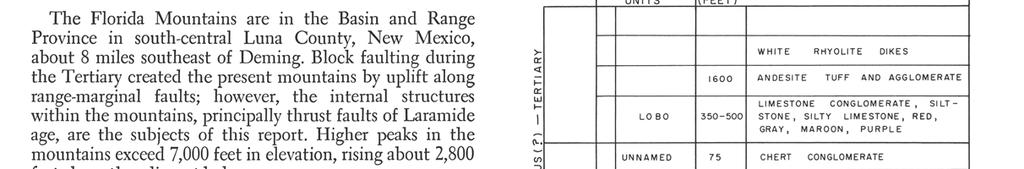
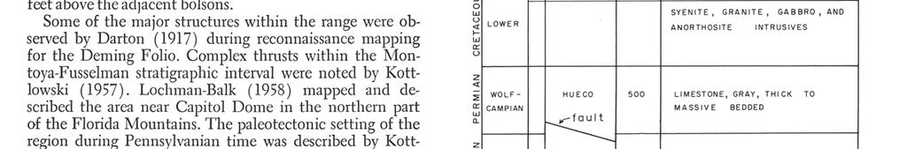
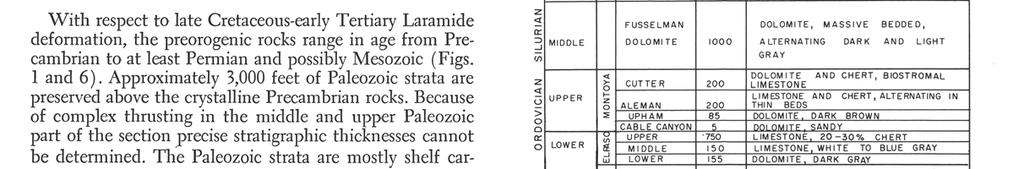
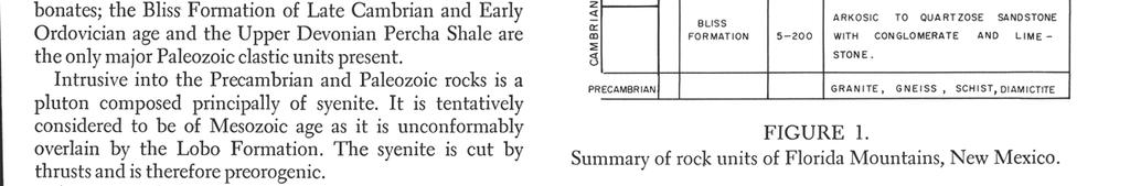
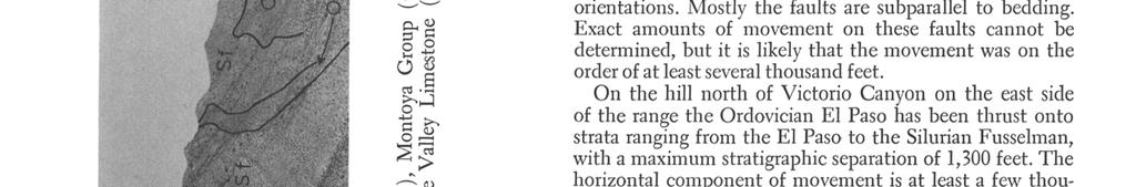
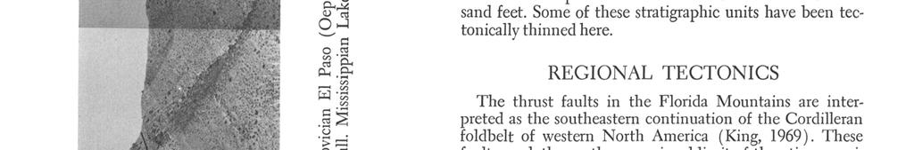
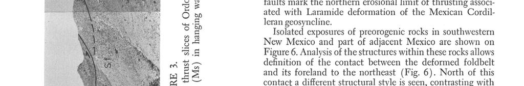
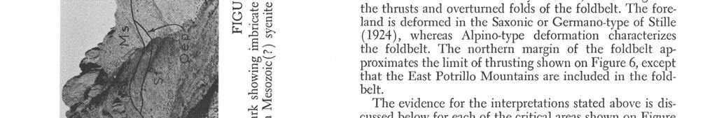
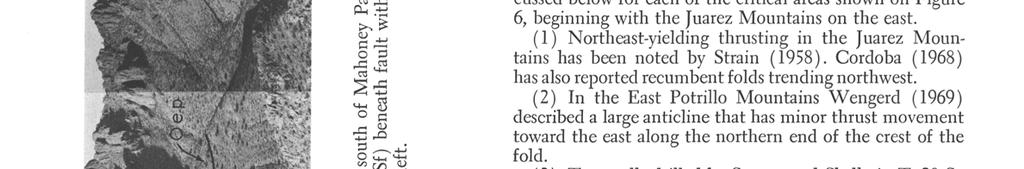
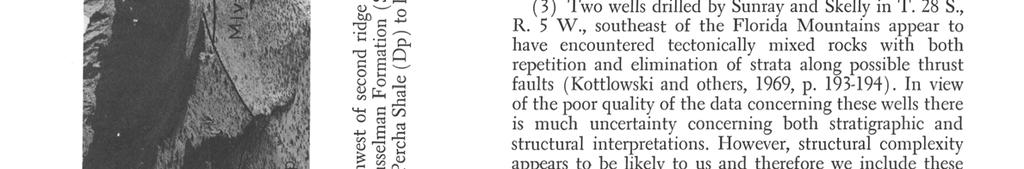
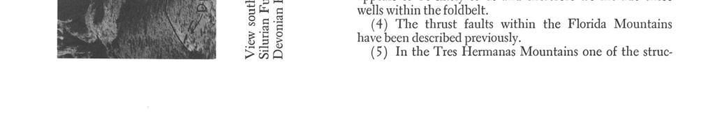
4 70 NEW MEXICO GEOLOGICAL SOCIETY-TWENTY-FIRST FIELD CONFERENCE cambrian, the Paleozoic, the syenitic intrusive rocks, and the thrusts. Although the age of the Lobo is uncertain, it is commonly considered to be Cretaceous (? ) or Tertiary (?) (Dane and Bachman, 1965). Regardless of its absolute age it is postorogenic with respect to thrust faults in the Florida Mountains. Other postorogenic rocks include an andesite agglomerate that disconformably overlies the Lobo Formation and rhyolite dikes that cut the agglomerate. PALEOTECTONIC SETTING From Cambrian through Mississippian time the Florida Mountains area was part of a stable shelf to the south of the Transcontinental Arch. At least three episodes of epeirogenic uplift during the Middle Ordovician, Early Silurian, and Late Silurian-Devonian are recorded by stratigraphic breaks. In Pennsylvanian time this shelf was epeirogenically deformed into a number of basins and uplifts and Kottlowski (1958) suggested the Florida Mountains area was a minor uplift between the Orogrande Basin to the northeast and the Pedregosa Basin to the south. It seems likely, however, that the Pennsylvanian strata are absent in the Florida Mountains because of tectonic elimination along Laramide faults rather than because of pre-hueco erosion. The Permian Hueco Formation indicates that shelf conditions again prevailed during Wolfcamp time. During the Mesozoic the Florida Mountains area was a southeastern extension of the Burro uplift described by Elston (1958). These positive elements comprised part of the more extensive Deming axis (Turner, 1962). Elston (1958) suggested that the Burro uplift was formed during the Early Cretaceous; Turner (1962), however, indicated that the Deming axis was probably positive throughout much of Mesozoic time. Syenitic and related intrusive rocks were probably emplaced in the Florida Mountains during the later part of the Mesozoic. The Deming axis appears to have been the northern margin of the Mexican geosyncline. Northward-yielding thrust faults and overturned folds developed during Laramide time within and along the northern margin of the Mexican geosyncline. These structures are considered in greater detail in the section concerning regional tectonics. Some of the elastic Lower Cretaceous rocks of southwestern New Mexico, including the Mojado Formation (Zeller, 1965), may represent synorogenic detritus derived from the deformed and uplifted Mexican geosyncline to the south. LARAMIDE STRUCTURES OF FLORIDA MOUNTAINS Thrusts and steep reverse faults that cut or deform rocks as young as the Lower Cretaceous (?) conglomerate and the syenitic intrusives of probable Mesozoic (? ) age are in turn unconformably overlain by the Lobo Formation of Cretaceous (? ) -Tertiary (? ) age. Thus, these faults appear to be Laramide. The most conspicuous fault is a northwest-trending, steeply dipping, reverse fault that has brought syenitic intrusive rocks over the Paleozoic strata in the southern part of the mountains. This fault is steep at deep structural levels, but flattens upward (Fig. 2). There is at least 2,000 feet of stratigraphic separation on this fault and it appears that the vertical component of movement is greater than the horizontal component. In the Paleozic strata beneath this fault, on the northeast side, is a complex of imbricate thrust slices that are particularly well exposed in the second ridge south of Mahoney Park in sections 34 and 35 of T. 25 S., R. 8 W. (Fig. 3). At this location undulating to gently dipping thrusts have repeated parts of the Montoya-Fusselman section three times (Fig. 4). There is also tectonic elimination of strata as well as repetition along some of the faults. The thrusts and the strata dip at an average of about 15 SE. The fault surfaces are commonly marked by brecciated zones up to 60 feet thick. Some of the breccia zones are locally silicified (Fig. 5). A precise calculation of slip on these faults cannot be made, but there must be at least 4,000 feet of horizontal yielding in a northerly direction. Presumably these imbricate slices are genetically related to the steeper fault described above where the syenite has been brought over the Paleozoics; it is possible that the imbricate thrusts are slightly older than the steep fault and have been offset by the latter fault. However, the absence of Paleozoic rocks on the south side of the steep fault precludes proving this possibility. At any rate, it seems likely that all these thrusts and steep reverse faults formed during the same general orogenic episode. Complex thrusting in the Paleozoic rocks beneath the major steep reverse fault is also seen at Gym Peak. Here the thrusts mainly involve tectonic elimination of strata although locally there is repetition of strata. In the canyon south of Gym Peak, below the major reverse fault, a thrust

5
 About 4 miles northwest of the Tres Hermanas Mountains are two small outcrops that consists of Silurian Fusselman Dolomite and Permo-Pennsylvanian strata.")
 Lower Paleozoic carbonates have been thrust northeastward onto Lower Cretaceous elastic rocks in the Snake Hills.")

6 tural interpretations from Balk's map and structure sections (1961) is that Silurian Fusselman Dolomite was thrust northeastward over the Permian Hucco Formation prior to intrusion of the large body of Tertiary quartz monzonite. (6) About 4 miles northwest of the Tres Hermanas Mountains are two small outcrops that consists of Silurian Fusselman Dolomite and Permo-Pennsylvanian strata. The outcrop patterns suggest that the Fusselman overlies the Permo-Pennsylvanian rocks; a thrust contact is inferred there. (7) Lower Paleozoic carbonates have been thrust northeastward onto Lower Cretaceous elastic rocks in the Snake Hills. (8) In the Victorio Mountains a reverse fault that has brought Ordovician El Paso strata northward over Lower Cretaceous elastic rocks was mapped by Kottlowski (in Griswold, 1961 ). This fault is interpreted as an overthrust marking the tectonic contact between the foldbelt and the foreland. (9) A small outcrop of tectonically mixed Fusselman, Montoya, and Lower Cretaceous conglomerate is present about 10 miles northwest of the Victorio Mountains. The structural complexity of these rocks is interpreted as the result of thrusting. (10) Zeller (1958a) described several thrusts in the Sierra Rica that trend northwest and dip toward the southwest. The main thrust has brought Paleozoic strata over the Cretaceous Mojado Formation. This thrust has 18,000 feet of stratigraphic throw and Zeller (1958a, p. 163) estimates that the thrust plate has moved on the order of miles and yielded toward the northeast. Several associated klippen and a fenster are described by Zeller. Other thrusts and reverse faults of smaller magnitude are also present in the Sierra Rica. (11) In the Little Hatchet Mountains Lasky (1947) reported bedding-plane faults and folds of Laramide age. The folds trend northwest. Also, the anomalous thickness of 21,000-25,000 feet of Lower Cretaceous strata reported by Lasky (1947) as well as repetition of nearly identical lithologies in this part of the section suggest that there may be low-angle thrusts present. Northwest of Granite Pass Paleozoic strata appear to have been thrust to the northeast over Lower Cretaceous rocks. (12) A thrust at Hatchet Gap was estimated to have over 25,000 feet of stratigraphic throw by Lasky (1947). This fault dips about 60 to the south and has placed upper Paleozoic strata on granitic rocks. Zeller (1958a) described several imbricate thrusts in the southwestern part of the Big Hatchet Mountains. These thrusts generally dip gently to the northeast and associated drag folds and overturned anticlines and synclines indicate yielding toward the southwest. Some of these thrusts locally steepen to high-angle reverse faults. Zeller (1958a, p. 57) indicated that these thrusts were of local extent and of relatively small movement. At any rate, the direction of yield-
7 ing is anomalous in view of the otherwise consistent yielding of the foldbelt toward the foreland to the north and east. (13) Zeller's map of the Playas quadrangle (1958b) shows three thrust slices at the north end of the Animas Mountains. These thrusts dip to the southwest and the lowest fault has brought Mississippian through Permian strata over Cretaceous sandstone. The middle thrust plate contains Precambrian through Devonian rocks that rest on Mississippian to Permian strata below. The uppermost thrust has brought Cretaceous strata over lower Paleozoic beds. Zeller (1958b) did not indicate the direction of yielding along these faults. We interpret northeast movement on these thrusts. (14) In the east-central Animas Mountains Zeller and Alper (1965) mapped closely compressed, northwest-trending folds in the Lower Cretaceous U-Bar Formation. (15) Sam Thompson III (in Zeller, 1965, p. 116) reported that in the Humble No. 1 N.M. State "BA" test well Ordovician El Paso strata were thrust onto Mississippian rocks at a depth of 14,120 feet. Thompson also indicated a reverse fault that repeated part of the Permian Epitaph Formation. (16) In the central Animas Valley two small outcrops of upper Paleozoic strata show northwest-trending fold axes with overturning toward the northeast. (17) In the central Peloncillo Mountains the broad, northwest-trending Peloncillo arch and the faults that cut the arch appear to be younger than the Laramide. Gillerman (1958) suggested that the northwest-trending faults
8 74 NEW MEXICO GEOLOGICAL SOCIETY TWENTY-FIRST FIELD CONFERENCE are characterized by strike-slip movement. He also inferred that the northwest-trending folds that are slightly diagonal to the faults resulted from secondary compression associated with strike-slip movement on the faults. Thus, the central Peloncillo Mountains appear to lie north of the Cordilleran foldbelt. Northeast-yielding thrusts are also reported along tectonic strike to the west in the Chiricahua and Dos Cabezas Mountains of eastern Arizona (Sabins, 1957). SUMMARY AND CONCLUSIONS The thrust faults observed in the Florida Mountains indicate a salient of the Cordilleran foldbelt that extends northward toward the foreland. Yielding along the margin of the foldbelt is northward toward the foreland. In view of the regional distribution of thrusts and folds it is likely that thrusts will be encountered throughout the foldbelt even though considerable parts of the section at any one locality may have escaped deformation. Extensive rocks unconformably covering the older rocks mask much of the structure so that only some of the tectonic framework can be seen from surface exposures. Basin-Range deformation is younger than the Laramide and therefore Laramide structures should be expected in the prcorogenic rocks that occur at depth in the basins between the present day ranges. By analogy with other foldbelt areas it seems that anomalous minor structures may be superimposed on the foldbelt. These structures might include folds, thrusts, or gravity-slide plates derived from intrusive doming or from block uplift during Basin-Range deformation. REFERENCES Balk, R., 1961, Geologic map and sections of Tres Hermanas Mountains: N. Mex. Bureau Mines and Min. Res. Geologic Map 16. Cordoba, D. A., 1968, Juarez Mountains: West Tex. Geol. Soc. Guidebook, Delaware Basin Exploration, p Dane, C. H. and Bachman, G. 0., 1965, Geologic map of New Mexico: U.S. Geol. Survey. Darton, N. H., 1917, Deming Folio, New Mexico: U.S. Geol. Survey Geologic Atlas, Folio 207. Elston, W. E. 1958, Burro uplift, northeastern limit of sedimentary basin of southwestern New Mexico and southeastern Arizona: Am. Assoc. Petroleum Geologists Bull., v. 42, p Gillerman, E., 1958, Geology of the central Peloncillo Mountains, Hidalgo County, New Mexico, and Cochise County, Arizona: N. Mex. Bureau of Mines and Min. Res. Bull. 57, 152 p. Griswold, G. B., 1961, Mineral deposits of Luna County, New Mexico: N. Mex. Bureau Mines and Min. Res. Bull. 72, 157 p. King, P. B., 1969, Tectonic map of North America, scale 1:5,000,000: U.S. Geol. Survey. Kottlowski, F. E., 1957, High-purity dolomite deposits of southcentral New Mexico: N. Mex. Bureau Mines and MM. Resources Circ. 47, 43 p. 1958, Pennsylvanian and Permian rocks near the late Paleozoic Florida islands: Roswell Geol. Soc. Guidebook, Hatchet Mountains and the Cooks Range-Florida Mountains area, p Foster, R. W., and Wengerd, S. A., 1969, Key oil tests and stratigraphic sections in southwest New Mexico: New Mex. Geol. Soc. Guidebook, The Border Region, p Lasky, S. G., 1947, Geology and ore deposits of the Little Hatchet Mountains, Hidalgo and Grant Counties, New Mexico: U.S. Geol. Survey Prof. Paper 208, 101 p. Lochman-Balk, C., 1958, The Capitol Dome section, Florida Mountains: Roswell Geol. Soc. Guidebook, Hatchet Mountains and Cooks Range-Florida Mountains area, p Sabins, F. F., 1957, Geology of the Cochise Head and western part of the Vanar quadrangles, Arizona: Geol. Soc. America Bull., v. 68, p Stille, H., 1924, Grundfragen der vergleichenden Tektonik: Borntraeger, Berlin. Strain, W. S., 1958, Juarez Mountains: West Tex. Geol. Soc. Guidebook, Franklin and Hueco Mountains, Texas, p. 67. Turner, G. L., 1962, The Deming axis, southeastern Arizona, New Mexico and Trans-Pecos Texas: New Mex. Geol. Soc. Guidebook, Mogollon Rim Region, p Wengerd, S. A., 1969, Geologic history and the exploration for oil in the border region: New Mex. Geol. Soc. Guidebook, The Border Region, p Zeller, R. A., 1958a, The geology of the Big Hatchet Peak Quadrangle, Hidalgo County, New Mexico: unpub. Ph. D. dissert. Univ. Calif. Los Angeles, 260 p. 1958b, Reconnaissance geologic map of Playas fifteen-minute quadrangle: N. Mex. Bureau Mines and Min. Res. Geologic Map , Stratigraphy of the Big Hatchet Mountains area, New Mexico: N. Mex. Bureau Mines and Min. Res. Mem. 16, 128 p. and Alper, A. M., 1965, Geology of the Walnut Wells quadrangle, Hidalgo County, New Mexico: N. Mex. Bureau Mines and Min. Res. Bull. 84, 105 p.
New Mexico Geological Society
 New Mexico Geological Society Downloaded from: http://nmgs.nmt.edu/publications/guidebooks/29 Laramide thrust faulting, Klondike Hills, southwestern New Mexico LeRoy L. Corbitt, F. L. Nials, and R. J.
New Mexico Geological Society
 New Mexico Geological Society Downloaded from: http://nmgs.nmt.edu/publications/guidebooks/26 Tectonic significance of the Pony Hills, Luna County, New Mexico LeRoy L. Corbitt and Fred L. Nials, 1975,
New Mexico Geological Society
 New Mexico Geological Society Downloaded from: http://nmgs.nmt.edu/publications/guidebooks/43 Volcanic geology of the Rio Puerco necks R. Bruce Hallett, 1992, pp. 135-144 in: San Juan Basin IV, Lucas,
New Mexico Geological Society
 New Mexico Geological Society Downloaded from: http://nmgs.nmt.edu/publications/guidebooks/25 Structure of the Guadalupe Box area, Sandoval County, New Mexico Harvey R. DuChene, 1974, pp. 131-135 in: Ghost
New Mexico Geological Society
 New Mexico Geological Society Downloaded from: http://nmgs.nmt.edu/publications/guidebooks/27 Structural framework of the southern Raton Basin, New Mexico Lee A. Woodward and D. O. Snyder, 1976, pp. 125-127
New Mexico Geological Society
 New Mexico Geological Society Downloaded from: http://nmgs.nmt.edu/publications/guidebooks/35 Structural anomalies in the Espanola Basin Bruce A. Black, 1984, pp. 59-62 in: Rio Grande Rift (Northern New
New Mexico Geological Society
 New Mexico Geological Society Downloaded from: http://nmgs.nmt.edu/publications/guidebooks/26 Direct-current soundings on the La Mesa surface near Kilbourne and Hunts Holes, New Mexico Dallas B. Jackson
GEOLOGIC MAPS PART II
 EARTH AND ENVIRONMENT THROUGH TIME LABORATORY - EES 1005 LABORATORY FIVE GEOLOGIC MAPS PART II Introduction Geologic maps of orogenic belts are much more complex than maps of the stable interior. Just
New Mexico Geological Society
 New Mexico Geological Society Downloaded from: http://nmgs.nmt.edu/publications/guidebooks/16 Geologic structure pattern of Grant County, New Mexico Frederick D. Trauger, 1965, pp. 184-187 in: Southwestern
New Mexico Geological Society
 New Mexico Geological Society Downloaded from: http://nmgs.nmt.edu/publications/guidebooks/21 Precambrian rocks of southwestern New Mexico Lee A. Woodward, 1970, pp. 27-31 in: Tyrone, Big Hatchet Mountain,
FACETS OF THE LATE PALEOZOIC STRATA IN SOUTHWESTERN NEW MEXICO
 141 FACETS OF THE LATE PALEOZOIC STRATA IN SOUTHWESTERN NEW MEXICO FRANK E. KOTTLOWSKI New Mexico Bureau of Mines and Mineral Resources Division, New Mexico Institute of Mining and Technology Where now
Structural Geology Lab. The Objectives are to gain experience
 Geology 2 Structural Geology Lab The Objectives are to gain experience 1. Drawing cross sections from information given on geologic maps. 2. Recognizing folds and naming their parts on stereoscopic air
New Mexico Geological Society
 New Mexico Geological Society Downloaded from: http://nmgs.nmt.edu/publications/guidebooks/13 Petrology and stratigraphy of near-reef Tansill-Lamar strata, Guadalupe Mountains Tyrrell, Willis W., Jr.,
New Mexico Geological Society
 New Mexico Geological Society Downloaded from: http://nmgs.nmt.edu/publications/guidebooks/13 Paleontological reconnaissance of subsurface Pennsylvanian in southern pache and Navajo Counties, rizona Donald
Name. GEOL.5220 Structural Geology Faults, Folds, Outcrop Patterns and Geologic Maps. I. Properties of Earth Materials
 I. Properties of Earth Materials GEOL.5220 Structural Geology Faults, Folds, Outcrop Patterns and Geologic Maps Name When rocks are subjected to differential stress the resulting build-up in strain can
Lab 4: Structures and Geologic Maps
 Key Questions: GEOL 1311 Earth Science Lab 4 Structures and Geologic Maps What shapes do rock bodies take in the Earth? How do two-dimensional visualizations of the Earth, such as maps and cross-sections
New Mexico Geological Society
 New Mexico Geological Society Downloaded from: http://nmgs.nmt.edu/publications/guidebooks/21 Stratigraphy of the Big Hatchet Mountains-Florida Mountains region Zeller, Robert A., Jr., 1970, pp. 44-58
New Mexico Geological Society
 New Mexico Geological Society Downloaded from: http://nmgs.nmt.edu/publications/guidebooks/24 Structural framework and tectonic evolution of the Four Corners region of the Colorado Plateau Lee A. Woodward,
New Mexico Geological Society
 New Mexico Geological Society Downloaded from: http://nmgs.nmt.edu/publications/guidebooks/19 Pennsylvanian correlations in southwestern Colorado Sherman A. Wengerd and Ernest Szabo, 1968, pp. 159-164
New Mexico Geological Society
 New Mexico Geological Society Downloaded from: http://nmgs.nmt.edu/publications/guidebooks/34 Recent measurements of crustal deformation related to the Socorro magma body, New Mexico Shawn Larsen and Robert
Structural Styles and Geotectonic Elements in Northwestern Mississippi: Interpreted from Gravity, Magnetic, and Proprietary 2D Seismic Data
 Structural Styles and Geotectonic Elements in Northwestern Mississippi: Interpreted from Gravity, Magnetic, and Proprietary 2D Seismic Data Nick Loundagin 1 and Gary L. Kinsland 2 1 6573 W. Euclid Pl.,
New Mexico Geological Society
 New Mexico Geological Society Downloaded from: http://nmgs.nmt.edu/publications/guidebooks/25 Outline of the igneous geology of the Jemez Mountain volcanic field A. M. Kudo, 1974, pp. 287-289 in: Ghost
New Mexico Geological Society
 New Mexico Geological Society Downloaded from: http://nmgs.nmt.edu/publications/guidebooks/18 Geomorphology and structure in the Grants mineral belt Robert A. Laverty, 1967, pp. 188-194 in: Defiance, Zuni,
New Mexico Geological Society
 New Mexico Geological Society Downloaded from: http://nmgs.nmt.edu/publications/guidebooks/31 Seismicity in the Basin and Range province of Texas and northeastern Chihuahua, Mexico David B. Dumas, 1980,
Answers: Internal Processes and Structures (Isostasy)
") Answers: Internal Processes and Structures (Isostasy) 1. Analyse the adjustment of the crust to changes in loads associated with volcanism, mountain building, erosion, and glaciation by using the concept
Answers: Internal Processes and Structures (Isostasy) 1. Analyse the adjustment of the crust to changes in loads associated with volcanism, mountain building, erosion, and glaciation by using the concept
New Mexico Geological Society
 New Mexico Geological Society Downloaded from: http://nmgs.nmt.edu/publications/guidebooks/23 Structural interpretation of the fractures associated with the Bonita Fault D. W. Stearns, 1972, pp. 161-164
GLY 155 Introduction to Physical Geology, W. Altermann. Press & Siever, compressive forces. Compressive forces cause folding and faulting.
 Press & Siever, 1995 compressive forces Compressive forces cause folding and faulting. faults 1 Uplift is followed by erosion, which creates new horizontal surface. lava flows Volcanic eruptions cover
New Mexico Geological Society
 New Mexico Geological Society Downloaded from: http://nmgs.nmt.edu/publications/guidebooks/19 Vanadium deposits of the Placerville area, San Miguel County, Colorado R. P. Fischer, 1968, pp. 100-103 in:
Geologic History of Texas: The Making of Texas Over 1.5 Billion Years
 # 4 Geologic History of Texas: The Making of Texas Over 1.5 Billion Years Dr. Richard Kyle March 24, 2000 Produced by and for Hot Science - Cool Talks by the Environmental Science Institute. We request
New Mexico Geological Society
 New Mexico Geological Society Downloaded from: http://nmgs.nmt.edu/publications/guidebooks/21 Upper Paleozoic and Cretaceous stratigraphy of the Hidalgo County area, New Mexico Eugene Greenwood, F. E.
New Mexico Geological Society
 New Mexico Geological Society Downloaded from: http://nmgs.nmt.edu/publications/guidebooks/20 Key oil tests and stratigraphic sections in southwest New Mexico Frank E. Kottlowski, Roy W. Foster, and S.
New Mexico Geological Society
 New Mexico Geological Society Downloaded from: http://nmgs.nmt.edu/publications/guidebooks/30 Structure and stratigraphy of the Hagan embayment--a new look Bruce A. Black, 1979, pp. 101-105 in: Santa Fe
STATE BUREAU OF MINES AND MINERAL RESOURCES NEW MEXICO INSTITUTE OF MINING AND TECHNOLOGY
 CIRCULAR 63 GEOLOGIC NOTES ON THE DELAWARE BASIN by Leon Haigler United States Geological Survey Published in cooperation with the United States Geological Survey 1962 STATE BUREAU OF MINES AND MINERAL
Strike-Slip Faults. ! Fault motion is parallel to the strike of the fault.
 Strike-Slip Faults! Fault motion is parallel to the strike of the fault.! Usually vertical, no hanging-wall/footwall blocks.! Classified by the relative sense of motion. " Right lateral opposite block
Lecture 6 Folds, Faults and Deformation Dr. Shwan Omar
 Fold: A fold is a bend or wrinkle of rock layers or foliation; folds form as a sequence of ductile deformation. Folding is the processes by which crustal forces deform an area of crust so that layers of
New Mexico Geological Society
 New Mexico Geological Society Downloaded from: http://nmgs.nmt.edu/publications/guidebooks/21 Contact metamorphism in the Tres Hermanas, Luna County, New Mexico Frank C. Homme and Abraham Rosenzweig, 1970,
Geologic Structures. Changes in the shape and/or orientation of rocks in response to applied stress
 Geologic Structures Changes in the shape and/or orientation of rocks in response to applied stress Figure 15.19 Can be as big as a breadbox Or much bigger than a breadbox Three basic types Fractures >>>
New Mexico Geological Society
 New Mexico Geological Society Downloaded from: http://nmgs.nmt.edu/publications/guidebooks/9 Summary of coal resources of the Black Mesa coal field, Arizona R. B. O'Sullivan, 1958, pp. 169-171 in: Black
UNDERSTANDING GEOLOGIC M APS
 Name: Lab Section: work in groups, but each person turns in his/her own GEOSCIENCE 001 L AB UNDERSTANDING GEOLOGIC M APS Geologic maps are colorful and even beautiful, but they also contain an amazing
Stress and Strain. Stress is a force per unit area. Strain is a change in size or shape in response to stress
 Geologic Structures Geologic structures are dynamically-produced patterns or arrangements of rock or sediment that result from, and give information about, forces within the Earth Produced as rocks change
Unconformities are depositional contacts that overlie rocks distinctly older than they are. They are often called gaps in the sedimentary record.
 UNCONFORMITIES Unconformities are depositional contacts that overlie rocks distinctly older than they are. They are often called gaps in the sedimentary record. The contact represents time when no sediment
Structural Geology Lab. The Objectives are to gain experience
 Geology 2 Structural Geology Lab The Objectives are to gain experience 1. Drawing cross sections from information given on geologic maps. 2. Recognizing folds and naming their parts on stereoscopic air
Chapter 15 Structures
 Chapter 15 Structures Plummer/McGeary/Carlson (c) The McGraw-Hill Companies, Inc. TECTONIC FORCES AT WORK Stress & Strain Stress Strain Compressive stress Shortening strain Tensional stress stretching
Geological Society of Nevada
 Geological Society of Nevada SOUTHERN NEVADA CHAPTER Newsletter March, 2001 PRESIDENT Chris Riechen Consultant VICE PRESIDENT Jean Cline UNLV Dept. of Geoscience TREASURER Paul Bowen Consultant SECRETARY
In this lab, we will study and analyze geologic maps from a few regions, including the Grand Canyon, western Wyoming, and coastal California.
 Name: Lab Section: work in groups, but each person turns in his/her own GEOSCIENCE 001 LAB UNDERSTANDING GEOLOGIC MAPS Geologic maps are colorful and even beautiful, but they also contain an amazing amount
Overview of Selected Shale Plays in New Mexico*
 Overview of Selected Shale Plays in New Mexico* Ron Broadhead 1 Search and Discovery Article #10627 (2014)** Posted August 18, 2014 *Adapted from presentation at RMAG luncheon meeting, Denver, Colorado,
New Mexico Geological Society
 New Mexico Geological Society Downloaded from: http://nmgs.nmt.edu/publications/guidebooks/9 Pennsylvanian paleogeography of Arizona Kay Havenor and Willard D. Pyr, 1958, pp. 78-81 in: Black Mesa Basin
NAME HOMEWORK ASSIGNMENT #3 MATERIAL COVERS CHAPTERS 8, 9, 10, 11
 NAME HOMEWORK ASSIGNMENT #3 MATERIAL OVERS HAPTERS 8, 9, 10, 11 Assignment is due the beginning of the class period on November 23, 2004. Answers for each chapter will be discussed in class, as Exam #3
New Mexico Geological Society
 New Mexico Geological Society Downloaded from: http://nmgs.nmt.edu/publications/guidebooks/29 Pennsylvanian and Early Permian depositional framework, southeastern Arizona Charles A. Ross, 1978, pp. 193-200
Geologic Map of the Hatch Quadrangle, Doña County, New Mexico
 Geologic Map of the Hatch Quadrangle, Doña County, New Mexico By William R. Seager May 1995 New Mexico Bureau of Geology and Mineral Resources Open-file Digital Geologic Map OF-GM 213 Scale 1:24,000 This
Earth Science, (Tarbuck/Lutgens) Chapter 10: Mountain Building
 Chapter 10: Mountain Building") Earth Science, (Tarbuck/Lutgens) Chapter 10: Mountain Building 1) A(n) fault has little or no vertical movements of the two blocks. A) stick slip B) oblique slip C) strike slip D) dip slip 2) In a(n) fault,
Earth Science, (Tarbuck/Lutgens) Chapter 10: Mountain Building 1) A(n) fault has little or no vertical movements of the two blocks. A) stick slip B) oblique slip C) strike slip D) dip slip 2) In a(n) fault,
Lecture # 6. Geological Structures
 1 Lecture # 6 Geological Structures ( Folds, Faults and Joints) Instructor: Dr. Attaullah Shah Department of Civil Engineering Swedish College of Engineering and Technology-Wah Cantt. 2 The wavy undulations
PRECAMBRIAN CRYSTALLINE AQUIFER (METAMORPHIC ROCKS)
") HAYWARD QUADRANGLE: Groundwater Production by Aquifer In the 56-square-mile area of the Hayward Quadrangle, groundwater is produced from metamorphic crystalline rocks of the Precambrian basement (in the
HAYWARD QUADRANGLE: Groundwater Production by Aquifer In the 56-square-mile area of the Hayward Quadrangle, groundwater is produced from metamorphic crystalline rocks of the Precambrian basement (in the
New Mexico Geological Society
 New Mexico Geological Society Downloaded from: http://nmgs.nmt.edu/publications/guidebooks/30 Geochronologic and rare-earth study of the Embudo granite and related rocks Marcia E. Register and D. G. Brookins,
L.O: HOW GEOLOGISTS SEQUENCE EVENTS IN EARTH'S GEOLOGIC HISTORY IF NOT OVERTURNED, OLDEST ON BOTTOM, YOUNGEST ON TOP
 L.O: HOW GEOLOGISTS SEQUENCE EVENTS IN EARTH'S GEOLOGIC HISTORY IF NOT OVERTURNED, OLDEST ON BOTTOM, YOUNGEST ON TOP 1. Unless a series of sedimentary rock layers has been overturned, the bottom rock layer
New Mexico Geological Society
 New Mexico Geological Society Downloaded from: http://nmgs.nmt.edu/publications/guidebooks/32 Rio Blanco Oil Shale Company Tract C-a, Rio Blanco County, Colorado: Summary of geology and current development
N30 E-45 SE S25 E-10 SW N85 W-80 NE
 Geologic aps and tructures Name Geology 100 Harbor section Read h. 7 before you begin. The objectives of this lab are for you to learn the basic geologic structures in 3- and to develop some facility in
New Mexico Geological Society
 New Mexico Geological Society Downloaded from: http://nmgs.nmt.edu/publications/guidebooks/26 Geology of the central Organ Mountains Dona Aña County, New Mexico Thomas G. Glover, 1975, pp. 157-161 in:
ENVI.2030L Geologic Time
 Name ENVI.2030L Geologic Time I. Introduction There are two types of geologic time, relative and absolute. In the case of relative time geologic events are arranged in their order of occurrence. No attempt
Geology of Quesnel and Stikine terranes and associated porphyry deposits. Jim Logan Paul Schiarizza
 Geology of Quesnel and Stikine terranes and associated porphyry deposits Jim Logan Paul Schiarizza Quesnel and Stikine terranes Major cordilleran terranes characterized by similar Late Triassic Early Jurassic
Structural Style in the Peel Region, NWT and Yukon
 Structural Style in the Peel Region, NWT and Yukon Adriana Taborda* Husky Energy and University of Calgary, Calgary, AB Adriana.Taborda@huskyenergy.ca and Deborah Spratt University of Calgary, Calgary,
New Mexico Geological Society
 New Mexico Geological Society Downloaded from: http://nmgs.nmt.edu/publications/guidebooks/27 Subsurface Paleozoic stratigraphy of the northeastern New Mexico basin and arch complex J. Wayland Roberts,
Topics Laramide Orogeny: Late Cretaceous to Early Eocene Reading: GSA DNAG volume 3, Ch. 6
 Topics Laramide Orogeny: Late Cretaceous to Early Eocene Reading: GSA DNAG volume 3, Ch. 6 Late Cretaceous to early Eocene New patterns developed 5 main regions Tectonic interpretations Post-Laramide events
!'f \, w. Alan Stewart Colorado Exploration Company, Golden STRUCTURE OF THE FOOTHILLS AREA WEST OF DENVER, COLORADO. Introduction
 STRUCTURE OF THE FOOTHLLS AREA WEST OF DENVER, COLORADO w. Alan Stewart Colorado Exploration Company, Golden ntroduction i ; The dominant structural features west of Denver and along the mountain front
Mineral Deposits of Luna County, New Mexico
 BULLETIN 72 Mineral Deposits of Luna County, New Mexico by GEORGE B. GRISWOLD 1961 STATE BUREAU OF MINES AND MINERAL RESOURCES NEW MEXICO INSTITUTE OF MINING & TECHNOLOGY CAMPUS STATION SOCORRO, NEW MEXICO
IP 121 ILLINOIS PETROLEUJM Illinois Institute of Natdral Resources STATE GEOWGICA SURVEY DIVISION' Jack A. Simon. Chief
 IP 121 ILLINOIS PETROLEUJM 121 1981 Illinois Institute of Natdral Resources STATE GEOWGICA SURVEY DIVISION' Jack A. Simon. Chief Stevenson, D. L. (David L.) Geologic structure of the base of the New Albany
Folding/Faulting: Topographic Expression of Folded Strata
 Folding/Faulting: Topographic Expression of Folded Strata Mountains: Orogenesis and Deformation Folding Faulting Joints & Fractures Domes and Basins Horst and Graben Rift Valleys US Examples: Sierra Nevada
Structural Geology of the Mountains
 Structural Geology of the Mountains Clinton R. Tippett Shell Canada Limited, Calgary, Alberta clinton.tippett@shell.ca INTRODUCTION The Southern Rocky Mountains of Canada (Figure 1) are made up of several
Mountains and Mountain Building: Chapter 11
 Mountains and Mountain Building: Chapter 11 Objectives: 1)Explain how some of Earth s major mountain belts formed 2) Compare and contrast active and passive continental margins 3) Explain how compression,
Crustal Deformation Earth - Chapter Pearson Education, Inc.
 Crustal Deformation Earth - Chapter 10 Structural Geology Structural geologists study the architecture and processes responsible for deformation of Earth s crust. A working knowledge of rock structures
ENGLE COAL FIELD. David E. Tabet
 OPEN FILE REPORT 115 SUMMARY OF THE GEOLOGY OF THE ENGLE COAL FIELD by David E. Tabet THE ENGLE COAL FIELD Introduction The Engle coal field (Lee, 1905), named for the small town of Engle along the Santa
General Geology Lab #7: Geologic Time & Relative Dating
 General Geology 89.101 Name: General Geology Lab #7: Geologic Time & Relative Dating Purpose: To use relative dating techniques to interpret geological cross sections. Procedure: Today we will be interpreting
Benefits of Integrated Seismic and Gravity Exploration: An example from Norman Wells, NWT
 Benefits of Integrated Seismic and Gravity Exploration: An example from Norman Wells, NWT J. Helen Isaac* and Donald C. Lawton Fold-Fault Research Project, University of Calgary 2500 University Drive NW,
Chapter 3. Geology & Tectonics
 Chapter 3 Geology & Tectonics 3.1 Geology The general geological features of Indonesia are shown in Figure 3.1. The basement formation is metamorphic and it is intruded with plutonic formations. They are
The McCully gas field in southern New Brunswick was discovered in the year 2000 on a joint drilling exploration venture by Corridor Resources Inc.
 1 The McCully gas field in southern New Brunswick was discovered in the year 2000 on a joint drilling exploration venture by Corridor Resources Inc. and Potash Corporation of Saskatchewan. Located about
New Mexico Geological Society
 New Mexico Geological Society Downloaded from: http://nmgs.nmt.edu/publications/guidebooks/19 Multiple intrusions in the San Miguel Mountains, Colorado Calvin S. Bromfield and Alfred L. Bush, 1968, pp.
GY 112L Earth History
 GY 112L Earth History Lab 2 Vertical Successions and Sequences of Events GY 112L Instructors: Douglas Haywick, James Connors, Mary Anne Connors Department of Earth Sciences, University of South Alabama
New Mexico Geological Society
 New Mexico Geological Society Downloaded from: http://nmgs.nmt.edu/publications/guidebooks/29 The Glance Conglomerate, a Lower Cretaceous syntectonic deposit in southeastern Arizona William L. Bilodeau,
How to Build a Mountain and other Geologic Structures. But first, questions
 How to Build a Mountain and other Geologic Structures But first, questions Questions your students might ask How were Montana s mountains formed? How old are the mountains? What are the different ways
Copyright McGraw-Hill Education. All rights reserved. No reproduction or distribution without the prior written consent of McGraw-Hill Education
 Copyright McGraw-Hill Education. All rights reserved. No reproduction or distribution without the prior written consent of McGraw-Hill Education Tibetan Plateau and Himalaya -southern Asia 11.00.a VE 10X
How mountains are made. We will talk about valleys (erosion and weathering later)
") How mountains are made We will talk about valleys (erosion and weathering later) http://www.ilike2learn.com/ilike2learn/mountainmaps/mountainranges.html Continent-continent plate convergence Less dense,
How mountains are made We will talk about valleys (erosion and weathering later) http://www.ilike2learn.com/ilike2learn/mountainmaps/mountainranges.html Continent-continent plate convergence Less dense,
Staple this part to part one of lab 6 and turn in. Lab 6, part two: Structural geology (analysis)
") Geology 101 Staple this part to part one of lab 6 and turn in Lab 6, part two: Structural geology (analysis) Recall that the objective of this lab is to describe the geologic structures of Cougar Mountain
Geology 101 Staple this part to part one of lab 6 and turn in Lab 6, part two: Structural geology (analysis) Recall that the objective of this lab is to describe the geologic structures of Cougar Mountain
How to Build a Mountain and other Geologic Structures. But first a short review
 How to Build a Mountain and other Geologic Structures But first a short review Where do we see deep earthquakes? What is happening there? What can happen at a plate boundary? 1. Plates can move apart
KEY CHAPTER 12 TAKE-HOME QUIZ INTERNAL STRUCTURES AND PROCESSES Score Part B = / 55 PART B
 GEOLOGY 12 KEY CHAPTER 12 TAKE-HOME QUIZ INTERNAL STRUCTURES AND PROCESSES Score Part B = / 55 PART B CHAPTER 12 Isostacy and Structural Geology 1. Using the terms below, label the following diagrams and
Deformation of Rocks. Orientation of Deformed Rocks
 Deformation of Rocks Folds and faults are geologic structures caused by deformation. Structural geology is the study of the deformation of rocks and its effects. Fig. 7.1 Orientation of Deformed Rocks
Why is it called the "Inland Basins" Region?
 Learning Series: Rocks of the Southeastern U. S. The BIG Picture Why is it called the "Inland Basins" Region? Inland from the mountains, the Earth s crust was buckled (downwarped) into a series of depressions
New Mexico Geological Society
 New Mexico Geological Society Downloaded from: http://nmgs.nmt.edu/publications/guidebooks/44 Small-scale structures in the Guadalupe Mountains region: Implication for Laramide stress trends in the Permian
New Mexico Geological Society
 New Mexico Geological Society Downloaded from: http://nmgs.nmt.edu/publications/guidebooks/31 Superposed deformation in the Santiago and northern Del Carmen Mountains, Trans-Pecos Texas Robert C. Cobb
Convergent plate boundary.
 Crustal Deformation Convergent plate boundary http://my.execpc.com/~acmelasr/mountains/geogramsnf.html Plate Tectonic Settings and Magma Where plates CONVERGE, water is driven off the subducting plate,
GEOLOGIC MAPS AND GEOLOGIC STRUCTURES A TEXAS EXAMPLE
 GEOLOGIC MAPS AND GEOLOGIC STRUCTURES A TEXAS EXAMPLE Roger Steinberg Assistant Professor of Geology Del Mar College 101 Baldwin Corpus Christi, TX 78404 361-698-1665 rsteinb@delmar.edu For the maps accompanying
Structure of the western Brooks Range fold and thrust belt, Arctic Alaska
 Trabajos de Geología, Universidad de Oviedo, 29 : 218-222 (2009) Structure of the western Brooks Range fold and thrust belt, Arctic Alaska J. DE VERA 1* AND K. MCCLAY 2 1Now at: Shell, Rijswijk, Netherlands.
GEOLOGIC AND TECTONIC FEATURES OF THE COYOTE MOUNTAINS, ARIZONA
 GEOLOGIC AND TECTONIC FEATURES OF THE COYOTE MOUNTAINS, ARIZONA JOSEPH G. WARGO AND WILLIAM L. KURTZ Department of Geology, Miami University, Oxford, Ohio Department of Geology, University of Arizona,
(1) Identify 5 major principles of relative dating? For each principle, describe how you tell what is younger and what is older.
 Identify 5 major principles of relative dating? For each principle, describe how you tell what is younger and what is older.") Things to Know - Third GLG101Exam Page 1 Important Note: This is not everything you need to know or study. However, it provides you with a relatively comprehensive list of questions to help you study.
Things to Know - Third GLG101Exam Page 1 Important Note: This is not everything you need to know or study. However, it provides you with a relatively comprehensive list of questions to help you study.
Gravel Transport Can Determine Late Flood Tectonics
 Chapter 23 Gravel Transport Can Determine Late Flood Tectonics The locations of all the quartzite gravel in the northwest states and adjacent Canada provide more information about the Flood than just reinforcing
GEOL 02: Historical Geology Lab 14: Topographic Maps. Name: Date:
 GEOL 02: Historical Geology Lab 14: Topographic Maps Name: Date: A topographic map is a two dimensional (flat) representation (model) of a three dimensional land surface (landscape). It shows landforms
Lab 6: Plate tectonics, structural geology and geologic maps
 Geology 103 Name(s): Lab 6: Plate tectonics, structural geology and geologic maps Objective: To show the effects of plate tectonics on a large-scale set of rocks and to reconstruct the geological history
New Mexico Geological Society
 New Mexico Geological Society Downloaded from: http://nmgs.nmt.edu/publications/guidebooks/33 Paleozoic history of the Albuquerque trough--implications for basement control on the Rio Grande rift Donald
Section 7. Reading the Geologic History of Your Community. What Do You See? Think About It. Investigate. Learning Outcomes
 Chapter 3 Minerals, Rocks, and Structures Section 7 Reading the Geologic History of Your Community What Do You See? Learning Outcomes In this section, you will Goals Text Learning Outcomes In this section,
Mesozoic Earth History
 Mesozoic Earth History The Mesozoic Era 251-66 MYA Breakup of Pangea Changes in air and oceanic currents Evolution of new terrestrial and marine life Opening of the Atlantic Ocean Basin Rocky Mountains
PRINCETON BASIN (92H/7E, 8W. 9W, 10E)
") PRINCETON BASIN (92H/7E, 8W. 9W, 10E) By R. D. McMechan INTRODUCTION Remapping of the Princeton basin, south-central British Columbia, was undertaken during the summer of 1975 in order to: (1) produce
PRINCETON BASIN (92H/7E, 8W. 9W, 10E) By R. D. McMechan INTRODUCTION Remapping of the Princeton basin, south-central British Columbia, was undertaken during the summer of 1975 in order to: (1) produce