Folding/Faulting: Topographic Expression of Folded Strata
|
|
|
- Dwain Daniels
- 6 years ago
- Views:
Transcription
1 Folding/Faulting: Topographic Expression of Folded Strata Mountains: Orogenesis and Deformation Folding Faulting Joints & Fractures Domes and Basins Horst and Graben Rift Valleys US Examples: Sierra Nevada Grand Tetons (Rocky Mountains) Appalachian Mountains 1

2 Orogenesis Orogenesis is the thickening of the continental crust and the building of mountains over millions of years. Orogeny encompasses all aspects of mountain formation including plate tectonics, terrane accretion, regional metamorphism, thrusting, folding, faulting, and igneous intrusions. South Carolina s Blue Ridge Mountains and Inner Piedmont Region were formed by multiple orogenic events when rocks were uplifted, metamorphosed, folded, faulted, and thrusted. Photo courtesy of SCGS, SCDNR 2


3 Deformation Deformation processes alter the earth s crust by extreme stress or pressure in the crust and mantle. Most deformation occurs along plate margins from plate tectonic movements. Folding and faulting are the most common deformation processes. Folding occurs when rocks are compressed such that the layers buckle and fold. Ductile deformation. Faulting occurs when rocks fracture under the accumulation of extreme stress created by compression and extensional forces. Brittle Deformation. Photo: South Carolina Geological Survey Photo: South Carolina Geological Survey 3

4 Deformation Structural Geology: the branch of geology that studies crustal deformation Notes: Folded Sandstone, Martin Bond/Science Photo Library/Photo Researchers, Inc.
 Compression Tension Shearing")
5 Deformation Stress: the agent of change, units are pressure (force/area) Compression Tension Shearing

6 Elastic deformation up to elastic limit Springs back to original shape Brittle failure (it breaks) Subjected to great stress that exceeds the elastic limit Subjected to sudden stress impact event Plastic deformation Does not spring back keeps deformed shape High temperature near melting High pressure squeezed like a ball of clay Deformation The ratio of change produced in the dimensions of a body by a system of forces, in equilibrium, to its original dimensions is called strain. Strain = Change in Dimension/Original Dimension
7 Factors Affecting Rock Deformation Intensity of applied stress Heat Temperature of the Rock Amount of Time the Stress is applied Rock Composition
8 Folding 8
9 Folding The crest of the fold, where the rock layers slope downward form the anticline. The valley of the fold where the layers slope toward the lower axis form the syncline. 9

10 Folding Anticlines and synclines can take on slightly different geometries depending on the compressional forces that form them. Very intense compressional forces form tight isoclinal folds, less intense compressional forces produce open folds. Folds can be asymmetric, upright, overturned, or curved. A fold pushed all the way over onto its side is called recumbent. 10
11 Fold Geometry 11


12 Folding: Scale Continuum Anticline exposed along NJ Route 23 near Butler NJ. Syncline valley between mountain peaks. Copyright USGS Overturned folds in the Table Rock gneiss in South Carolina s piedmont. Copyright Michael Lejeune Recumbent folds in limestone. SCGS photo Copyright Marli Miller, University of Oregon 12
 innermost rocks oldest")

13 Folding Syncline (downfold) innermost rocks youngest Anticline (upfold) innermost rocks oldest Note: anticlines and synclines are structures in rocks, not surface landforms Anticlinal Ridge Synclinal Valley

14 Folded Landforms: Influence of Denundation


15 Plunging Folds Source: GEOPIC, Earth Satellite Corporation

16 Domes and Basins Domes and basins are large, elongated folds formed by broad warping processes including mantle convection, isostatic adjustment, or swelling from a hot spot. Domes contain strata which increase in age toward the center as the younger layers are eroded from the top and sides. Basins contain strata which is youngest toward the center and the oldest rocks form the flanks or sides. This geologic map of the Michigan Basin illustrates the circular pattern of the sedimentary strata. The green color in the center of the map represents the youngest rocks which are Upper Pennsylvanian; and the rocks progressively increase in age toward the periphery where the reddish-orange colors represent the oldest rocks flanking this structure which are Ordovician and Cambrian age. Oldest Rocks (Ordivician and Cambrian) Youngest rocks (Upper Pennsylvanian) 16


17 3D-Folds Domes resemble anticlines, but the beds dip uniformly in all directions away from the center of the structure. Domes are caused by compression and uplift. Basins resemble synclines, but the beds dip uniformly in all directions toward the center of the structure. Basins are caused by compression and downwarping. 17

18 3D-Folds Dome Formation: Impact Structures Refolding Diapirism: the process in which an igneous intrusion deforms the overlying more brittle rocks. The Richat Strurcture in the Sahara Desert of Mauritania. Long considered to be an impact structure, it is now believed by most to be a structural dome. 18

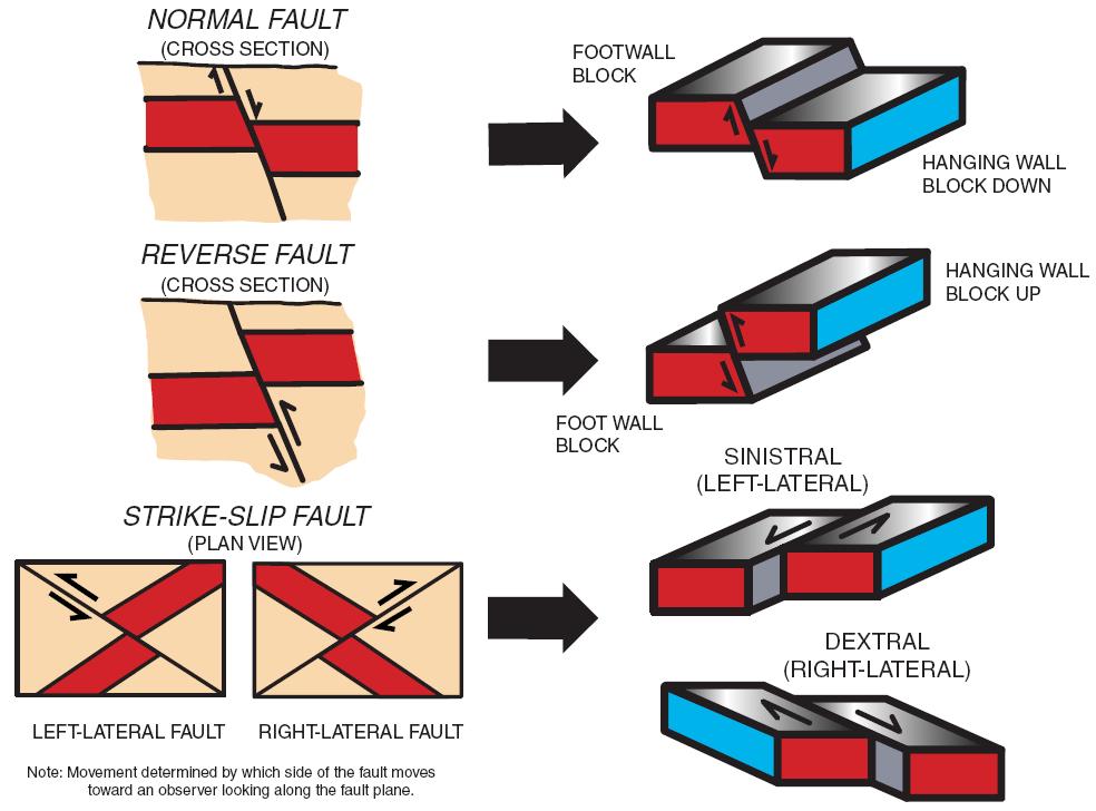
19 Faulting Faulting occurs when the rocks fail under deformation processes. A fault is a planar discontinuity along which displacement of the rocks occurs. Normal: rocks above the fault plane, or hanging wall, move down relative to the rocks below the fault plane, or footwall. Reverse: rocks above the hanging wall moves up relative to the footwall Strike-slip: rocks on either side of a nearly vertical fault plane move horizontally Oblique-slip: normal or reverse faults have some strike-slip movement, or when strike-slip faults have normal or reverse movement 19

20 Faulting 20


21 Fractures and Joints Joints occur where a rock breaks but there is no displacement or faulting associated with the break. Joints are not singular features, but they occur in sets within a given type or area of a rock. Fractures are breaks in rocks that are often singular more random features and are not associated with a set of joints. Fractures often occur in association with faults or folds. Fractures and joints create a variety of pathways for water to flow through, which weaken the rock and facilitate chemical, biological, and mechanical weathering processes. 21


22 Fractures and Joints Common forms of jointing are columnar, sheet jointing, and tensional joints. Columnar jointing occurs when igneous rocks cool and develop shrinkage joints along pillar-like columns. Sheeting joints occur when the layers of rock release pressure and exfoliate along parallel planes. Brittle fractures and tensional joints are caused by regionally extensive compressional or elongated pressures along folds in the crustal rocks. 22


23 Jointing The image below is of vertical jointed, bedded metasandstone in the Snake Range in Nevada. Copyright Bruce Molnia, USGS Copyright Larry Fellows, Arizona Geological Survey These two images are an example of columnar jointing. The image on the top is a side view and the image below is from the top. These hexagonal columns of rock formed from cooled basalt are part of Devil s Postpile National Monument in California. 23


24 Jointing Rock Fins Model for Arches National Park 24

25 Horst and Graben: Basin and Range Horst and graben topography is generated by normal faulting associated with crustal extension. The central block termed graben is bounded by normal faults and the graben drops as the crust separates. The graben forms an elongated valley that is bound by uplifted ridge-like mountainous structures referred to as horsts. Basin and Range topography, Nevada. Copyright Marli Miller, University of Oregon 25

26 Horst and Graben: Basin and Range Some horsts may tilt slightly producing asymmetric, tilted terrane or mountain ranges. In the Western United States, horst and graben fault sequences are described as Basin and Range topography. Basin and Range topography, Nevada. Copyright Marli Miller, University of Oregon 26


27 Faulting: Rotation Fault Slices Fault Splinters 27

28 Faulting: Strike-Slip 28


29 Reverse Faulting Glencoul Thrust, Scotland Common along convergent boundaries. Often involves sedimentary environments Accretionary Wedges Fold & Thrust Mnts, Himalayas, Appalachians, Alps Often low angle thrusts 29

30 Tilted Fault Block Mnts Sierra Nevada Grand Tetons Basin & Range Province 30

31 Appalachian Mountains This is an aerial view of the Susquehanna River in Pennsylvania flowing through the folded and faulted Valley and Ridge Province of the Appalachian Mountains. Extend Alabama to Maine in the US, and through the southeastern provinces of Canada to Newfoundland. Formed during the Paleozoic Era from several orogenic episodes, Taconic Orogeny (Ordovician ~480 mya) Acadian Orogeny (Devonian ~400 mya) Alleghany Orogeny (Permian ~ 300 mya). Each of these major orogenic episodes involved multiple events of folding, faulting, metamorphism, emplacements of igneous intrusions, and uplift. 31


32 European Alps The European Alps began forming during the Alpine Orogeny (~ mya) with the collision of the African Plate moving northward into the European Plate. This motion is still active today as the Alps continue to uplift, fold, fault, and accrete. Major orogenic events involved recumbent folding and thrust faulting of crystalline basement rocks. African Plate Switzerland Germany Austria European Plate France Italy Slovenia Modified from: The Matterhorn, on the border between Switzerland an Italy, is one of the most familiar mountains in the world and is a popular climbing site. The continent-continent collision resulted in the peak of the Matterhorn containing bedrock from the African Plate while the lower portions contain bedrock from the European Plate. 32

33 Himalaya Mountains Himalaya orogeny began million years ago from the collision between the India and Eurasian Plates and is still active today. When two continental plates collide, the Earth s crust at the plate boundaries is folded, faulted, overthrusted, uplifted forming an extensive continental mountain range. 33
Chapter. Mountain Building
 Chapter Mountain Building 11.1 Rock Deformation Factors Affecting Deformation Factors that influence the strength of a rock and how it will deform include temperature, confining pressure, rock type, and
11.1 Rock Deformation
 Tarbuck Lutgens Mountain Building 11.1 Rock Deformation Factors Affecting Deformation Factors that influence the strength of a rock and how it will deform include temperature, confining pressure, rock
Chapter 15 Structures
 Chapter 15 Structures Plummer/McGeary/Carlson (c) The McGraw-Hill Companies, Inc. TECTONIC FORCES AT WORK Stress & Strain Stress Strain Compressive stress Shortening strain Tensional stress stretching
Geologic Structures. Changes in the shape and/or orientation of rocks in response to applied stress
 Geologic Structures Changes in the shape and/or orientation of rocks in response to applied stress Figure 15.19 Can be as big as a breadbox Or much bigger than a breadbox Three basic types Fractures >>>
Crustal Deformation Earth - Chapter Pearson Education, Inc.
 Crustal Deformation Earth - Chapter 10 Structural Geology Structural geologists study the architecture and processes responsible for deformation of Earth s crust. A working knowledge of rock structures
Earth Science, (Tarbuck/Lutgens) Chapter 10: Mountain Building
 Chapter 10: Mountain Building") Earth Science, (Tarbuck/Lutgens) Chapter 10: Mountain Building 1) A(n) fault has little or no vertical movements of the two blocks. A) stick slip B) oblique slip C) strike slip D) dip slip 2) In a(n) fault,
Earth Science, (Tarbuck/Lutgens) Chapter 10: Mountain Building 1) A(n) fault has little or no vertical movements of the two blocks. A) stick slip B) oblique slip C) strike slip D) dip slip 2) In a(n) fault,
Essentials of Geology, 11e
 Essentials of Geology, 11e Crustal Deformation and Mountain Building Chapter 17 Instructor Jennifer Barson Spokane Falls Community College Geology 101 Stanley Hatfield Southwestern Illinois College Jennifer
Deformation of Rocks. Orientation of Deformed Rocks
 Deformation of Rocks Folds and faults are geologic structures caused by deformation. Structural geology is the study of the deformation of rocks and its effects. Fig. 7.1 Orientation of Deformed Rocks
What Causes Rock to Deform?
 Crustal Deformation Earth, Chapter 10 Chapter 10 Crustal Deformation What Causes Rock to Deform? Deformation is a general term that refers to all changes in the shape or position of a rock body in response
KEY CHAPTER 12 TAKE-HOME QUIZ INTERNAL STRUCTURES AND PROCESSES Score Part B = / 55 PART B
 GEOLOGY 12 KEY CHAPTER 12 TAKE-HOME QUIZ INTERNAL STRUCTURES AND PROCESSES Score Part B = / 55 PART B CHAPTER 12 Isostacy and Structural Geology 1. Using the terms below, label the following diagrams and
Chapter 16. Mountain Building. Mountain Building. Mountains and Plate Tectonics. what s the connection?
 Chapter 16 Mountains and Plate Tectonics what s the connection? Mountain Building Most crustal deformation occurs along plate margins. S.2 Active Margin Passive Margin Mountain Building Factors Affecting
Lecture Outlines PowerPoint. Chapter 10 Earth Science, 12e Tarbuck/Lutgens
 Lecture Outlines PowerPoint Chapter 10 Earth Science, 12e Tarbuck/Lutgens 2009 Pearson Prentice Hall This work is protected by United States copyright laws and is provided solely for the use of instructors
Stress and Strain. Stress is a force per unit area. Strain is a change in size or shape in response to stress
 Geologic Structures Geologic structures are dynamically-produced patterns or arrangements of rock or sediment that result from, and give information about, forces within the Earth Produced as rocks change
CRUSTAL DEFORMATION. Chapter 10
 CRUSTAL DEFORMATION and dgeologic Structures t Chapter 10 Deformation Df Deformation involves: Stress the amount of force applied to a given area. Types of Stress: Confining Stress stress applied equally
Mountains and Mountain Building: Chapter 11
 Mountains and Mountain Building: Chapter 11 Objectives: 1)Explain how some of Earth s major mountain belts formed 2) Compare and contrast active and passive continental margins 3) Explain how compression,
Chapter 10: Volcanoes and Other Igneous Activity Section 1: The Nature of Volcanic Eruptions I. Factors Affecting Eruptions Group # Main Idea:
 Chapter 10: Volcanoes and Other Igneous Activity Section 1: The Nature of Volcanic Eruptions I. Factors Affecting Eruptions Group # A. Viscosity Group # B. Dissolved Gases Group # II. Volcanic Material
How mountains are made. We will talk about valleys (erosion and weathering later)
") How mountains are made We will talk about valleys (erosion and weathering later) http://www.ilike2learn.com/ilike2learn/mountainmaps/mountainranges.html Continent-continent plate convergence Less dense,
How mountains are made We will talk about valleys (erosion and weathering later) http://www.ilike2learn.com/ilike2learn/mountainmaps/mountainranges.html Continent-continent plate convergence Less dense,
Section 10.1 The Nature of Volcanic Eruptions This section discusses volcanic eruptions, types of volcanoes, and other volcanic landforms.
 Chapter 10 Section 10.1 The Nature of Volcanic Eruptions This section discusses volcanic eruptions, types of volcanoes, and other volcanic landforms. Reading Strategy Previewing Before you read the section,
Crustal Deformation. (Building Earth s Surface, Part 1) Science 330 Summer Mapping geologic structures
 Science 330 Summer Mapping geologic structures") Crustal Deformation (Building Earth s Surface, Part 1) Science 330 Summer 2005 Mapping geologic structures When conducting a study of a region, a geologist identifies and describes the dominant rock structures
Crustal Deformation (Building Earth s Surface, Part 1) Science 330 Summer 2005 Mapping geologic structures When conducting a study of a region, a geologist identifies and describes the dominant rock structures
Crustal Deformation. Earth Systems 3209
 Crustal Deformation Earth Systems 3209 Crustal Deformation pg. 415 Refers to all changes in the original form and/or size of a rock body. May also produce changes in the location and orientation of rocks.
Study the architecture and processes responsible for deformation of Earth s crust. Folding and Faulting
 Crustal Deformation AKA Structural geology (adapted from Brunkel, 2012) Study the architecture and processes responsible for deformation of Earth s crust. Folding and Faulting How Rocks Deform: 4 Controls
How to Build a Mountain and other Geologic Structures. But first a short review
 How to Build a Mountain and other Geologic Structures But first a short review Where do we see deep earthquakes? What is happening there? What can happen at a plate boundary? 1. Plates can move apart
Chapter 10: Deformation and Mountain Building. Fig. 10.1
 Chapter 10: Deformation and Mountain Building Fig. 10.1 OBJECTIVES Describe the processes of rock deformation and compare and contrast ductile and brittle behavior in rocks. Explain how strike and dip
How to Build a Mountain and other Geologic Structures. But first, questions
 How to Build a Mountain and other Geologic Structures But first, questions Questions your students might ask How were Montana s mountains formed? How old are the mountains? What are the different ways
UNIT 10 MOUNTAIN BUILDING AND EVOLUTION OF CONTINENTS
 UNIT 10 MOUNTAIN BUILDING AND EVOLUTION OF CONTINENTS ROCK DEFORMATION Tectonic forces exert different types of stress on rocks in different geologic environments. STRESS The first, called confining stress
December 21, Chapter 11 mountain building E.notebook. Feb 19 8:19 AM. Feb 19 9:28 AM
 Mountains form along convergent plate boundaries. Typically (usually) if you look at a mountain range, you know that it is at a plate boundary (active continental margin) or has been some time in the past
Lab 7: STRUCTURAL GEOLOGY FOLDS AND FAULTS
 Lab 7: STRUCTURAL GEOLOGY FOLDS AND FAULTS This set of labs will focus on the structures that result from deformation in earth s crust, namely folds and faults. By the end of these labs you should be able
Lecture 6 Folds, Faults and Deformation Dr. Shwan Omar
 Fold: A fold is a bend or wrinkle of rock layers or foliation; folds form as a sequence of ductile deformation. Folding is the processes by which crustal forces deform an area of crust so that layers of
Learning Objectives (LO) What we ll learn today:!
 What we ll learn today:!") Learning Objectives (LO) Lecture 13: Mountain Building Read: Chapter 10 Homework #11 due Tuesday 12pm What we ll learn today:! 1. Define the types of stress that are present in the crust! 2. Define the
Learning Objectives (LO) Lecture 13: Mountain Building Read: Chapter 10 Homework #11 due Tuesday 12pm What we ll learn today:! 1. Define the types of stress that are present in the crust! 2. Define the
Strike-Slip Faults. ! Fault motion is parallel to the strike of the fault.
 Strike-Slip Faults! Fault motion is parallel to the strike of the fault.! Usually vertical, no hanging-wall/footwall blocks.! Classified by the relative sense of motion. " Right lateral opposite block
Mountain Building. Mountain Building
 Mountain Building Mountain building has occurred during the recent geologic past American Cordillera the western margin of the Americas from Cape Horn to Alaska Includes the Andes and Rocky Mountains Alpine
FINAL EXAM Crustal Deformation CONVERGE DIVERGENT PLATES MANTLE PLUMES FLUX BASALTIC GRANITIC
 Crustal Deformation Reading: Chapter 10 Pages 283-304 Review Questions 4, 6, 7, 10, 12, 15, 18, 20 FINAL EXAM NOON TO 2 PM, TUESDAY DEC. 5 HERE: Natural Science 101 BRING A SCAN TRON TURN IN YOUR REVIEW
Answers: Internal Processes and Structures (Isostasy)
") Answers: Internal Processes and Structures (Isostasy) 1. Analyse the adjustment of the crust to changes in loads associated with volcanism, mountain building, erosion, and glaciation by using the concept
Answers: Internal Processes and Structures (Isostasy) 1. Analyse the adjustment of the crust to changes in loads associated with volcanism, mountain building, erosion, and glaciation by using the concept
Evolution of Continents Chapter 20
 Evolution of Continents Chapter 20 Does not contain complete lecture notes. Mountain belts Orogenesis the processes that collectively produce a mountain belt Includes folding, thrust faulting, metamorphism,
Directed Reading. Section: How Mountains Form MOUNTAIN RANGES AND SYSTEMS. Skills Worksheet
 Skills Worksheet Directed Reading Section: How Mountains Form 1. How high is Mount Everest? a. about 1980 km above sea level b. more than 8 km below sea level c. more than 8 km above sea level d. more
Lecture 9 faults, folds and mountain building
 Lecture 9 faults, folds and mountain building Rock deformation Deformation = all changes in size, shape, orientation, or position of a rock mass Structural geology is the study of rock deformation Deformation
Copyright McGraw-Hill Education. All rights reserved. No reproduction or distribution without the prior written consent of McGraw-Hill Education
 Copyright McGraw-Hill Education. All rights reserved. No reproduction or distribution without the prior written consent of McGraw-Hill Education Tibetan Plateau and Himalaya -southern Asia 11.00.a VE 10X
Geomorphology Final Exam Study Guide
 Geomorphology Final Exam Study Guide Geologic Structures STRUCTURAL GEOLOGY concerned with shapes, arrangement, interrelationships of bedrock units & endogenic (within) forces that cause them. Tectonic
Convergent plate boundary.
 Crustal Deformation Convergent plate boundary http://my.execpc.com/~acmelasr/mountains/geogramsnf.html Plate Tectonic Settings and Magma Where plates CONVERGE, water is driven off the subducting plate,
Faults, folds and mountain building
 Faults, folds and mountain building Mountain belts Deformation Orogens (Oro = Greek all changes for mountain, in size, shape, genesis orientation, = Greek for or formation) position of a rock mass Structural
Structural Geology and Geology Maps Lab
 Structural Geology and Geology Maps Lab Mesa College Geology 101 Lab Ray Rector: Instructor Structural Geology Lab Pre-Lab Resources Pre-Lab Internet Links 1) Fundamentals of Structural Geology 2) Visualizing
Earth Science Lesson Plan Quarter 3, Week 7, Day 1
 Earth Science Lesson Plan Quarter 3, Week 7, Day 1 Outcomes for Today Standard Focus: PREPARE 1. Background knowledge necessary for today s reading. Continental ice sheets increase the weight of the Earth
GLY 155 Introduction to Physical Geology, W. Altermann. Press & Siever, compressive forces. Compressive forces cause folding and faulting.
 Press & Siever, 1995 compressive forces Compressive forces cause folding and faulting. faults 1 Uplift is followed by erosion, which creates new horizontal surface. lava flows Volcanic eruptions cover
Forces That Shape Earth. How do continents move? What forces can change rocks? How does plate motion affect the rock cycle?
 Forces That Shape Earth How do continents move? What forces can change rocks? How does plate motion affect the rock cycle? Plate Motion Mountain ranges are produced by plate tectonics. The theory of plate
Staple this part to part one of lab 6 and turn in. Lab 6, part two: Structural geology (analysis)
") Geology 101 Staple this part to part one of lab 6 and turn in Lab 6, part two: Structural geology (analysis) Recall that the objective of this lab is to describe the geologic structures of Cougar Mountain
Geology 101 Staple this part to part one of lab 6 and turn in Lab 6, part two: Structural geology (analysis) Recall that the objective of this lab is to describe the geologic structures of Cougar Mountain
Continental Landscapes
 Continental Landscapes Landscape influenced by tectonics, climate & differential weathering Most landforms developed within the last 2 million years System moves toward an equilibrium Continental Landscapes
Unit 4 Lesson 3 Mountain Building. Copyright Houghton Mifflin Harcourt Publishing Company
 Stressed Out How can tectonic plate motion cause deformation? The movement of tectonic plates causes stress on rock structures. Stress is the amount of force per unit area that is placed on an object.
FINAL EXAM Crustal Deformation CONVERGE DIVERGENT PLATES MANTLE PLUMES FLUX BASALTIC GRANITIC
 Crustal Deformation Reading: Chapter 10 Pages 283-294 FINAL EXAM 8 to 10 AM, THURSDAY DEC. 6 HERE: Natural Science 101 BRING A SCAN TRON TURN IN YOUR REVIEW QUESTIONS BEFORE THE TEST, PICK UP WHEN YOU
An aerial view from the south of the eruption of Mount St. Helens volcano on May 18, 1980.
 1 2 3 4 5 6 7 8 9 10 Building Earth s Surface Tillery, Chapter 21 Science 330 Summer 2007 An aerial view from the south of the eruption of Mount St. Helens volcano on May 18, 1980. Interpreting Earth s
Lecture Outline Friday March 2 thru Wednesday March 7, 2018
 Lecture Outline Friday March 2 thru Wednesday March 7, 2018 Questions? Lecture Exam Friday March 9, 2018 Same time, Same room Bring Pencils and WSU ID 50 question Multiple Choice, Computer Graded Interlude
Instructor s Manual Chapter 10. Deformation, Mountain Building, and the Continents
 Chapter 10 Table of Contents Chapter Outline Learning Outcomes Chapter Summary Lecture Suggestions Enrichment Topics Common Misconceptions Consider This Key Terms Internet Sites, Videos, Software, and
Part I. PRELAB SECTION To be completed before labs starts:
 Student Name: Physical Geology 101 Laboratory #13 Structural Geology II Drawing and Analyzing Folds and Faults Grade: Introduction & Purpose: Structural geology is the study of how geologic rock units
Lecture # 6. Geological Structures
 1 Lecture # 6 Geological Structures ( Folds, Faults and Joints) Instructor: Dr. Attaullah Shah Department of Civil Engineering Swedish College of Engineering and Technology-Wah Cantt. 2 The wavy undulations
Unit 4 Lesson 7 Mountain Building
 Indiana Standards 7.2.4 Explain how convection currents in the mantle cause lithospheric plates to move causing fast changes like earthquakes and volcanic eruptions, and slow changes like creation of mountains
Name. GEOL.5220 Structural Geology Faults, Folds, Outcrop Patterns and Geologic Maps. I. Properties of Earth Materials
 I. Properties of Earth Materials GEOL.5220 Structural Geology Faults, Folds, Outcrop Patterns and Geologic Maps Name When rocks are subjected to differential stress the resulting build-up in strain can
Section 3 Deforming Earth s Crust
 Section 3 Deforming Earth s Crust Key Concept Tectonic plate motions deform Earth s crust. Deformation causes rock layers to bend and break and causes mountains to form. What You Will Learn Stress is placed
Earth s Many Landforms. Earth s Many Landforms. Earth s Many Landforms. Crustal Deformation. Crustal Deformation 10/22/2014
 Hewitt/Lyons/Suchocki/Yeh Conceptual Integrated Science Chapter 24 EARTH S SURFACE LAND AND WATER Earth s Many Landforms Earth consists of seven continents: Africa, Antarctica, Asia, Australia, Europe,
GEOLOGIC MAPS PART II
 EARTH AND ENVIRONMENT THROUGH TIME LABORATORY - EES 1005 LABORATORY FIVE GEOLOGIC MAPS PART II Introduction Geologic maps of orogenic belts are much more complex than maps of the stable interior. Just
Crags, Cracks, and Crumples: Crustal Deformation and Mountain Building
 Crags, Cracks, and Crumples: Crustal Deformation and Mountain Building Updated by: Rick Oches, Professor of Geology & Environmental Sciences Bentley University Waltham, Massachusetts Based on slides prepared
Shape Earth. Plate Boundaries. Building. Building
 Chapter Introduction Lesson 1 Lesson 2 Lesson 3 Lesson 4 Chapter Wrap-Up Forces That Shape Earth Landforms at Plate Boundaries Mountain Building Continent Building How is Earth s surface shaped by plate
Tectonic plates of the world
 Mountain Building Tectonic plates of the world ISOSTACY Isostatic Rebound crust rises as a result of removal of mass This iceberg also demonstrates the process of isostatic rebound. Types of Mountains
Plate Tectonics. entirely rock both and rock
 Plate Tectonics I. Tectonics A. Tectonic Forces are forces generated from within Earth causing rock to become. B. 1. The study of the origin and arrangement of Earth surface including mountain belts, continents,
6.1 Geological Stresses
 www.ck12.org Chapter 6. Geological Activity from Plate Tectonics Processes 6.1 Geological Stresses Define the types of geological stress and describe their affect on various types of rock under a range
Mountains are then built by deforming crust: Deformation & Mountain Building. Mountains form where stresses are high!
 Deformation & Mountain Building Where are mountains located? Deformation and Folding Mountain building Mountains form where stresses are high! Mountains form at all three types of plate boundaries where
Plate Tectonics - Demonstration
 Name: Reference: Prof. Larry Braile - Educational Resources Copyright 2000. L. Braile. Permission granted for reproduction for non-commercial uses. http://web.ics.purdue.edu/~braile/indexlinks/educ.htm
Tectonics is a study of the major structural features of the Earth s crust or a broad structure of a region. Tecto- means building
 TECTONICS AND TECTONIC STRUCTURES Tectonics is a study of the major structural features of the Earth s crust or a broad structure of a region. Tecto- means building The plate theory Different stages are
GEOL 110. Sedimentary Layering. Geologic Structures (faults, joints, folds), Unconformities, Karst. Sedimentary Layering 9/23/17. Geologic Structures
, Unconformities, Karst. Sedimentary Layering 9/23/17. Geologic Structures") GEOL 110 Sedimentary Layering Geologic Structures (faults, joints, folds), Unconformities, Karst Layering = horizontal, continuous banding produced during sediment deposition Sedimentary Layering Geologic
GEOL 110 Sedimentary Layering Geologic Structures (faults, joints, folds), Unconformities, Karst Layering = horizontal, continuous banding produced during sediment deposition Sedimentary Layering Geologic
Location and Distance on Earth (Chapter 22 part 1)
") GEOLOGY 306 Laboratory Instructor: TERRY J. BOROUGHS NAME: Location and Distance on Earth (Chapter 22 part 1) For this assignment you will require: a calculator, protractor, and a metric ruler, and an
GEOLOGY 306 Laboratory Instructor: TERRY J. BOROUGHS NAME: Location and Distance on Earth (Chapter 22 part 1) For this assignment you will require: a calculator, protractor, and a metric ruler, and an
NC Earth Science Essential Standards
 NC Earth Science Essential Standards EEn. 2.1 Explain how processes and forces affect the Lithosphere. EEn. 2.1.1 Explain how the rock cycle, plate tectonics, volcanoes, and earthquakes impact the Lithosphere.
Geology of Landscapes Chapter 6 (Building Earth s Surface Faulting and Folding)
") Geology of Landscapes Chapter 6 (Building Earth s Surface Faulting and Folding) Process of _ that the earth s Stress and Strain Any solid material responds to a force in a way that depends on: pressure
Geology of Landscapes Chapter 6 (Building Earth s Surface Faulting and Folding) Process of _ that the earth s Stress and Strain Any solid material responds to a force in a way that depends on: pressure
1. classic definition = study of deformed rocks in the upper crust
 Structural Geology I. Introduction 1. classic definition = study of deformed rocks in the upper crust deformed includes translation, rotation, and strain (change of shape) All rocks are deformed in some
Section 2: How Mountains Form
 Section 2: How Mountains Form Preview Objectives Mountain Ranges and Systems Plate Tectonics and Mountains Types of Mountains Objectives Identify the types of plate collisions that form mountains. Identify
Movement of the Earth s Crust: Formation of: Mountain s Plateau's and Dome s
 Movement of the Earth s Crust: Formation of: Mountain s Plateau's and Dome s References Information taken from several places including Prentice Hall Earth Science: @ http://www.eram.k12.ny.us/education/components/docmgr/default.php?sectiondetaili
Mountains, like those shown in Figure 1, provide some of the most
 Section 11.1 11.1 Rock Deformation 1 FOCUS Section Objectives 11.1 Identify the factors that determine the strength of a rock and how it will deform. 11.2 Explain how rocks permanently deform. 11.3 Distinguish
3/5/05 Dr. Stewart 1
 I. Physiography of Appalachian Mountains A. Introduction 1. These mountains extend from NE Canada to Georgia 2. They are the remains of a deeply eroded, ancient mountain chain once larger than the Himalayans
Lab 6: Plate tectonics, structural geology and geologic maps
 Geology 103 Name(s): Lab 6: Plate tectonics, structural geology and geologic maps Objective: To show the effects of plate tectonics on a large-scale set of rocks and to reconstruct the geological history
Deformation: Modification of Rocks by Folding and Fracturing
 CHAPTER 7 Deformation: Modification of Rocks by Folding and Fracturing Chapter Summary A geologic map is a scientific model of rock formations that are exposed on the Earth s surface showing outcrops,
LANDFORMS. Patterns and Processes
 LANDFORMS Patterns and Processes Structure From the surface the Earth is a planet of continents and oceans. There is constant motion on the earth s surface. Seismology is the study of earthquakes. Scientists
Structural Geology of the Mountains
 Structural Geology of the Mountains Clinton R. Tippett Shell Canada Limited, Calgary, Alberta clinton.tippett@shell.ca INTRODUCTION The Southern Rocky Mountains of Canada (Figure 1) are made up of several
The Building of the NYC Region
 The Building of the NYC Region Definitions Fall Line marks the area where an upland region (continental bedrock) and a coastal plain meet Piedmont the plateau region of the eastern United States which
Structural Geology Lab. The Objectives are to gain experience
 Geology 2 Structural Geology Lab The Objectives are to gain experience 1. Drawing cross sections from information given on geologic maps. 2. Recognizing folds and naming their parts on stereoscopic air
Forces in Earth s Crust
 Forces in Earth s Crust This section explains how stresses in Earth s crust cause breaks, or faults, in the crust. The section also explains how faults and folds in Earth s crust form mountains. Use Target
Deformation of the Crust
 Deformation of the Crust Review Choose the best response. Write the letter of that choice in the space provided. 1. The state of balance between the thickness of the crust and the depth at which it rides
Plate Tectonics GEOL 101 Lecture 22 How Are Mountains Built?
 Plate Tectonics GEOL 101 Lecture 22 How Are Mountains Built? The Grand Tetons, Wyoming First a Brief Review of Sea Floor Spreading Prop: Test 3 Invitations Break-Up of a Continent and Origin of an Ocean
ANNOUNCEMENTS. Neighbor MEET & GREET. Turn to Neighbor: What is the difference between accretionary wedges and terranes?
 ANNOUNCEMENTS THIS WEEK Thursday class: Please bring scissors! NEXT WEEK Wed CLASS: Bring a mechanical compass if have one. Neighbor MEET & GREET 1. Each person take out a sheet of paper and write LEGIBLY
NAME HOMEWORK ASSIGNMENT #4 MATERIAL COVERS CHAPTERS 19, 20, 21, & 2
 NAME HOMEWORK ASSIGNMENT #4 MATERIAL COVERS CHAPTERS 19, 20, 21, & 2 Assignment is due the beginning of the class period on December 14, 2004. Mark answers on a scantron sheet, which will be provided.
Do NOT open the test until instructed to do so.
 Raw Score: Rank: School: Team Number: Names: Boyceville Invitational, December 2, 2017 Dynamic Planet Plate Tectonics and Geographical Impacts Do NOT open the test until instructed to do so. 2011 Tohoku
4 Deforming the Earth s Crust
 CHAPTER 7 4 Deforming the Earth s Crust SECTION Plate Tectonics BEFORE YOU READ After you read this section, you should be able to answer these questions: What happens when rock is placed under stress?
Name Student ID Exam 2c GEOL 1113 Fall 2009
 Name Student ID Exam 2c GEOL 1113 Fall 2009 1. When a marine geologist collects a core of undeformed ocean-floor sediment, she knows that the youngest layer is on the top of the core and the oldest is
Earth Movement and Resultant Landforms
 Earth Movement and Resultant Landforms Structure of the Earth Lithosphere : earth s crust Asthenosphere : upper mantle zone where material is near its melting point & acts almost like liquid (appprox.
(1) Identify 5 major principles of relative dating? For each principle, describe how you tell what is younger and what is older.
 Identify 5 major principles of relative dating? For each principle, describe how you tell what is younger and what is older.") Things to Know - Third GLG101Exam Page 1 Important Note: This is not everything you need to know or study. However, it provides you with a relatively comprehensive list of questions to help you study.
Things to Know - Third GLG101Exam Page 1 Important Note: This is not everything you need to know or study. However, it provides you with a relatively comprehensive list of questions to help you study.
Geology 300, Physical Geology Spring 2019 Quiz Ch 19, Plate Tectonics Name
 Geology 300, Physical Geology Spring 2019 Quiz Ch 19, Plate Tectonics Name MULTIPLE CHOICE. Choose the one alternative that best completes the statement or answers the question. 1) The portion of a fracture
4 Deforming the Earth s Crust
 CHAPTER 7 4 Deforming the Earth s Crust SECTION Plate Tectonics BEFORE YOU READ After you read this section, you should be able to answer these questions: What happens when rock is placed under stress?
Beneath our Feet: The 4 Layers of the Earty by Kelly Hashway
 Beneath our Feet: The 4 Layers of the Earty by Kelly Hashway The Earth is more than a giant ball made up of dirt, rocks, and minerals. The Earth may look like a giant ball from when looking at it from
10. Paleomagnetism and Polar Wandering Curves.
 Map of ocean floor Evidence in Support of the Theory of Plate Tectonics 10. Paleomagnetism and Polar Wandering Curves. The Earth's magnetic field behaves as if there were a bar magnet in the center of
The Earth s Structure. The Lithosphere and Tectonic. The Lithosphere and Tectonic. System. Chapter 12. The Earth s Interior
 The Lithosphere and Tectonic System Chapter 12 The Lithosphere and Tectonic System The theory describing the changing configuration of the continents through time is called plate tectonics. Plate tectonic
Layers of the Earth Date: SWABT: Identify and describe the layers of the Earth and their characteristics
 Layers of the Earth SWABT: Identify and describe the layers of the Earth and their characteristics CRUST Composition: Thickness: State of Matter: : Mostly Basalt : Mostly Granite : Crust and Upper Mantle
1. occurs when the oceanic crust slides under the continental crust.
 1. occurs when the oceanic crust slides under the continental crust. 2. What type of stress is shown? 3. Where two plates slide past one another is called a boundary. 4. What type of stress is shown? 5.
A Classification of Forces Affecting the Landforms
 Landforms There are many forms of land on the surface of the earth. Continents, oceans, mountains, plateaus, valleys, deltas, etc., are some of the examples of landforms. Landforms can be divided into
TOPOGRAPHIC RELIEF MAP of NYS. LANDFORMS of NYS. Landforms. Creation of NYS Landforms 9/22/2011
 TOPOGRAPHIC RELIEF MAP of NYS LANDFORMS of NYS Prof. Anthony Grande AFG 2011 Landforms The basis of present-day landforms (surface features) is the bedrock geology that has been worked on by the forces