Year 11 Geography. Paper 1 Global Geographical Issues. Mock Exam Revision Booklet
|
|
|
- Godfrey Sherman
- 6 years ago
- Views:
Transcription

1 Year 11 Geography Paper 1 Global Geographical Issues Mock Exam Revision Booklet
2 Contents Page Topic Exam Command Words How to structure your answers Tectonics Checklist Tectonics Key Words Tectonics Revision Material Tectonics Practice Questions Tropical Cyclones Learning Checklist Tropical Cyclones Key Words Tropical Cyclones Revision Material Tropical Cyclones Practice Questions Development Dynamics Checklist Development Dynamics Key Words Development Dynamics Revision Material Development Dynamics Practice Questions Page Number
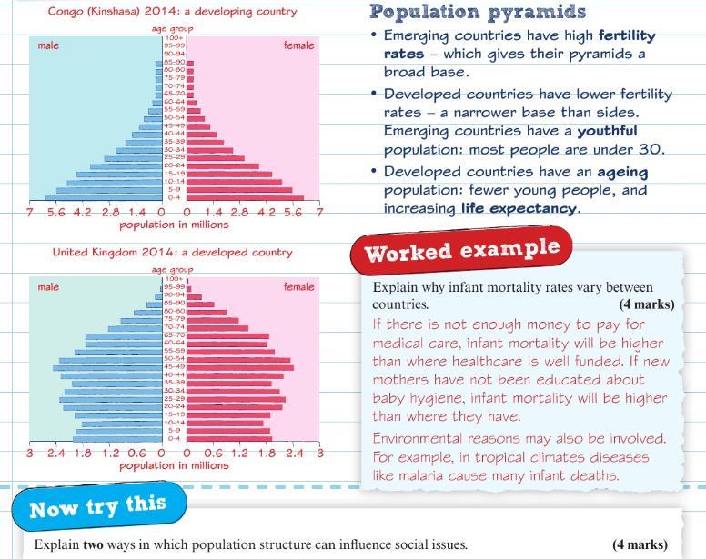
3 Command Word Identify/ Name/ State Exam Command Words Marks Meaning Example Question Sentence Starters/ Hints 1 Find/give a simple statement Identify the landform in the photo Define 1 Give the meaning Define the term fertility rate Calculate 1 or 2 Work out Calculate the mean age of a group of people Label 1 or 2 Print the name of/ Write on a map or diagram Draw 2 or 3 Sketch/ Draw a line Compare 3 Find the similarities and differences Label 2 features of the river in Figure 2 Draw a line to complete the graph in Figure 3 Compare the rate of population growth in 2 cities I can see. An example is This means. The term? means. Show your working out Use correct Geographical terminology Always draw in pencil This figure shows As you can see One similarity/ one difference that is evident Describe 2 or 3 What is it like/ Trends on graphs Describe the trends shown in Figure 1. Describe the increase in population Use PQE: Pattern Quantity Exceptions Use GCSE General Comment Specific Example or Exceptions Explain 2, 3 or 4 Give reasons why it happens Explain the formation of a meander PEE paragraphs This is because.. Suggest 2,3 or 4 Give a wellreasoned guess to explain Suggest reasons why flooding has become more frequent along this river One possible reason It may be that In some cases we might Assess 8 Weigh up which is most/least important Evaluate 8 Give a judgement: which is most/ least effective Select & Justify 12 Select and then give evidence to support Assess the need for coastal management along a stretch of coastline you studied Evaluate the methods used in collecting data in your fieldwork Select and justify the best option for the future of On one hand Some may suggest that The most important reason could be Evidence suggests Although In certain situations Contributed to Overall The reason for this Significant impacts However To conclude Some may suggest
4 How to structure your answers 1 mark Identify, State, Name, Define, Calculate, Label Write a simple sentence or just a few words 2 marks Calculate You must show your workings out Label Label/annotate at least 2 main things Draw Draw a diagram and label/annotate at least 2 main parts Describe state 2 things Explain Point, Explain Suggest Point, Development 3 marks Draw Draw a diagram and label/annotate at least 3 main parts Compare At least one difference and one similarity plus another of your choice Describe state 3 things Explain & Suggest Point & 2 development or Point, Development, Point 4 marks Explain & Suggest Point & Development x 2 8 marks 4 marks for explanation & 4 marks for use of evidence Assess Explanation Requires you to explain which you think is the most important aspect of something in relation to others. Give 4 reasons for your decision or opinion Use of evidence May require you to find evidence in a figure and/or use your own knowledge to give evidence for your decisions. Learn case studies and named examples. Evaluate E.g. Global responses to climate change are more important than local response because. Require you to explain how successful you think something is or has been. Give 4 reasons for your decision. E.g. India has been successful in managing the environmental impacts of slims in Mumbai because Require you to use your own knowledge of the world to answer the question and provide evidence. Learn case studies and named examples.
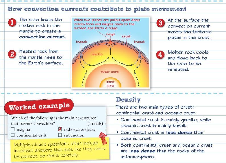
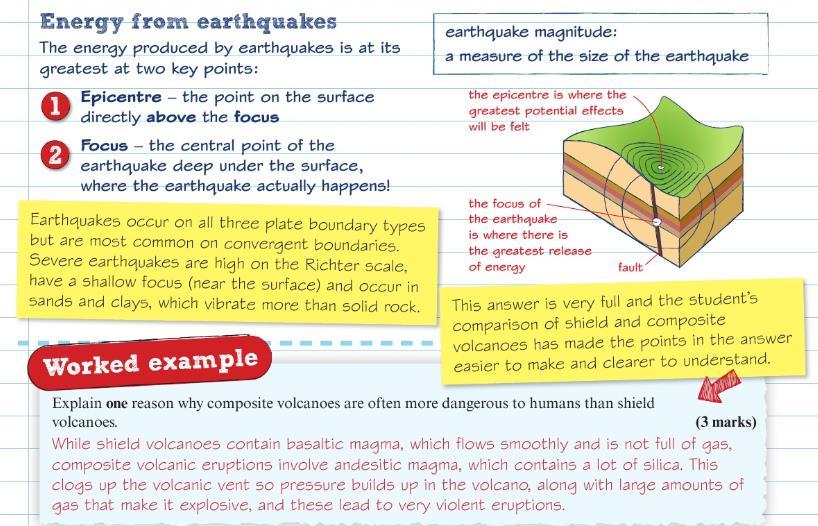
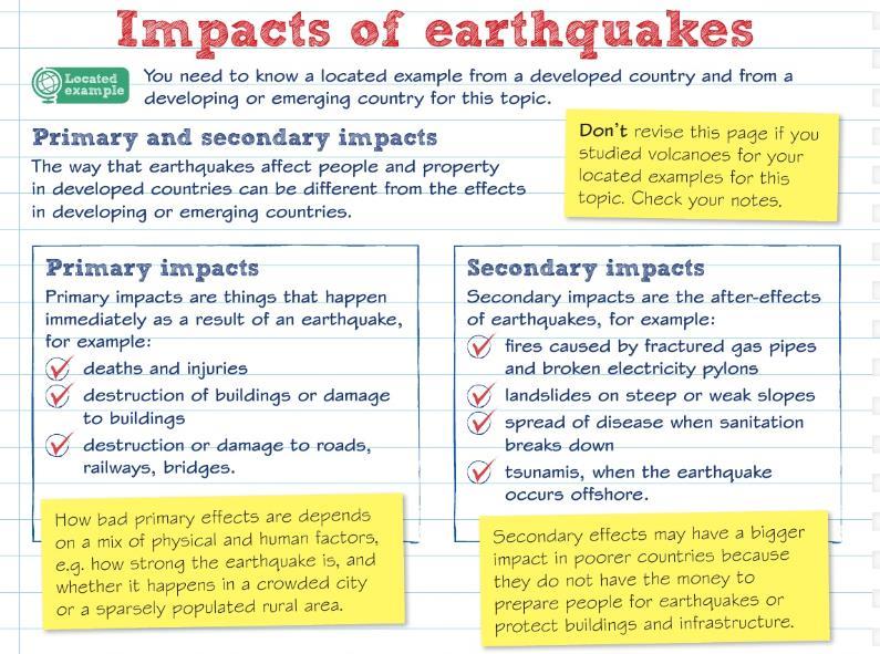
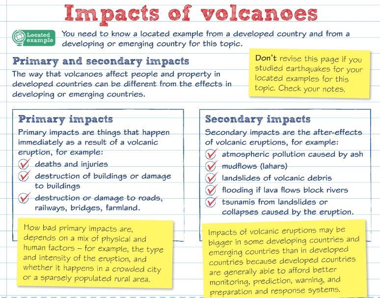
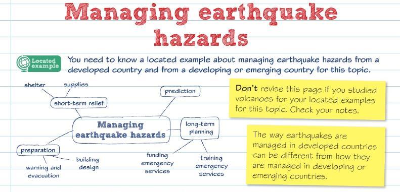
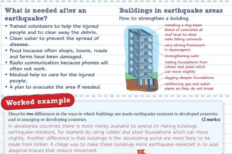
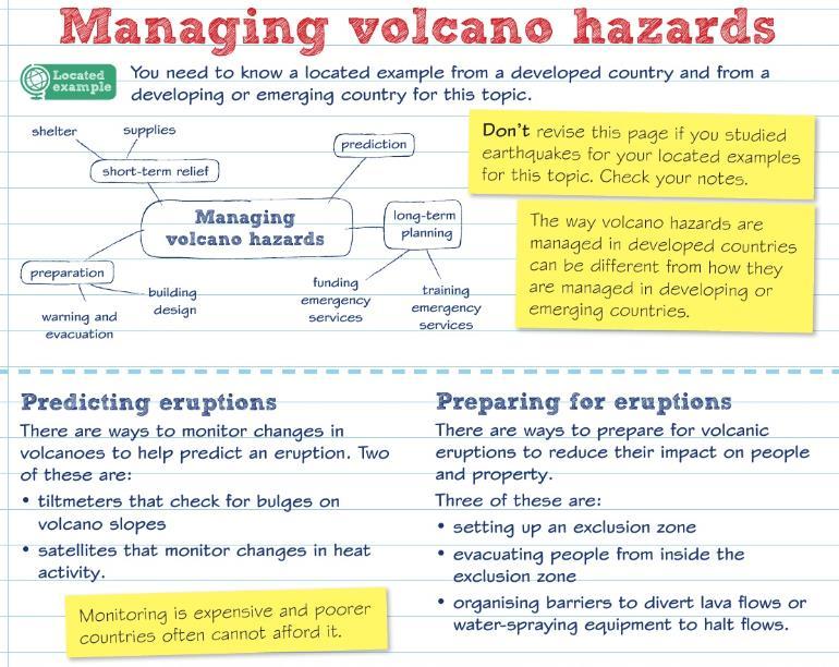
5 Tectonics Checklist Learning Objective How do you feel? I understand the different layers of the earth and their characteristics I understand how the heat of the inner core drives convection currents and moves plates I understand the three main plate boundaries and their features. I also understand hotspots I understand how different volcanoes are formed and how they are different hazards I understand how earthquakes and tsunamis form I understand the primary and secondary effects of an earthquake in a MEDC and a LEDC I understand how earthquakes can be managed in a MEDC and a LEDC including Short Term and Long Term responses and the 3Ps Tectonics Key Words Keyword Aftershocks Aid Collision zones Conservative plate boundary Continental crust Definition a less-powerful earthquake which follows a morepowerful earthquake a result of the fault 'settling' into its new position short-term help such as food, given in emergency, or long-term help such as training in health care where two tectonic plates collide forming mountains fold mountains like the Himalayas where two tectonic plates are sliding alongside each other, in the same or different directions the part of the Earth s crust that makes up land, on average km thick
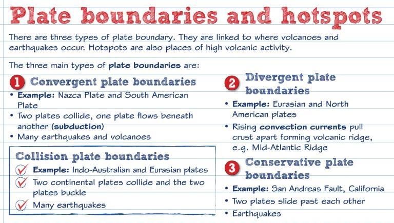
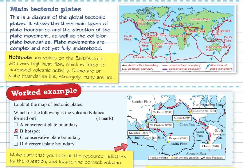
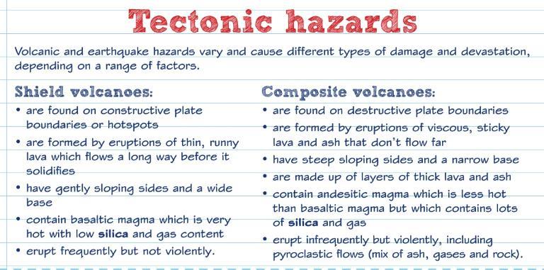
6 Convection currents Convergent plate boundary Core Divergent plate boundary Economic impacts Epicentre Evacuate Focus Friction Geothermal Lava Lava flows Lithosphere Magma Magnitude Oceanic crust Plate Currents which transfer heat from one part of a liquid or gas to another. where two tectonic plates collide the centre of Earth, believed to be solid inside with a hot liquid outer core where two tectonic plates are moving away from each other impacts on the wealth of an area the point on the ground directly above the focus (centre) of an earthquake when people move from a place of danger to a safer place the point of origin of an earthquake the force which resists the movement of one surface over another heat from inside the Earth melted rock that erupts from a volcano lava flows at different speeds, depending on what it is made of. Lava flows are normally very slow and not hazardous but, when mixed with water, lava can flow very fast and be dangerous the cool and brittle uppermost layer of the Earth. It includes the very top of the mantle and, above this, the crust melted rock below the Earth s surface. When it reaches the surface it is called lava of an earthquake (how much the ground shakes), an expression of the total energy released the part of the Earth s crust which is under the oceans, usually 6-8 km thick where tectonic plates meet. There are three kinds
7 boundaries Predict Primary effects Probability Pyroclasts Relief effort Richter scale Secondary effects Seismometer Social impacts Stratovolcano Subduction Tectonic hazards Tectonic plate Volcanic Explosivity Index (VEI) of boundary a) divergent when two plates move apart b) convergent when two plates collide c) conservative when two plates slide past one another saying that something will happen in the future. A scientific prediction is based on statistical evidence the direct impacts of event, usually occurring instantly the chance of an event happening fragments of volcanic material that is thrown out during explosive eruptions help given by organisations or countries to help those facing an emergency a scale for measuring the magnitude of earthquakes the indirect impacts of an event, usually occurring in the hours, weeks, months or years after the event a machine for recording and measuring an earthquake using the Richter scale the impacts of an event upon people type of volcano characterised by steep sides, also known as a composite cone describes oceanic crust sinking into the mantle at a convergent plate boundary. As the crust subducts, it melts back into the mantle natural events caused by movement of the Earth s plates that affect people and property the Earth s surface is broken into large pieces, like a cracked eggshell. The pieces are called tectonic plates, or just plates measures the explosiveness of volcanic eruptions on a scale of 1 to 8

8 Tectonics Revision Material
9
10
11
12
13
14

15 Tectonics Practice Questions
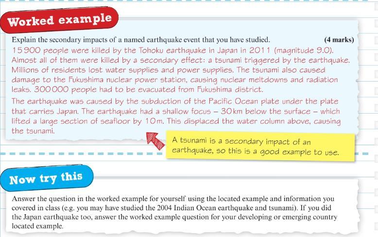
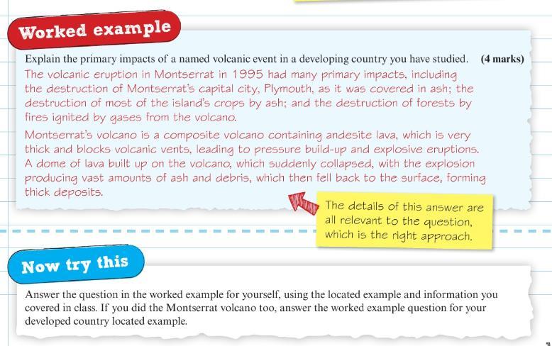
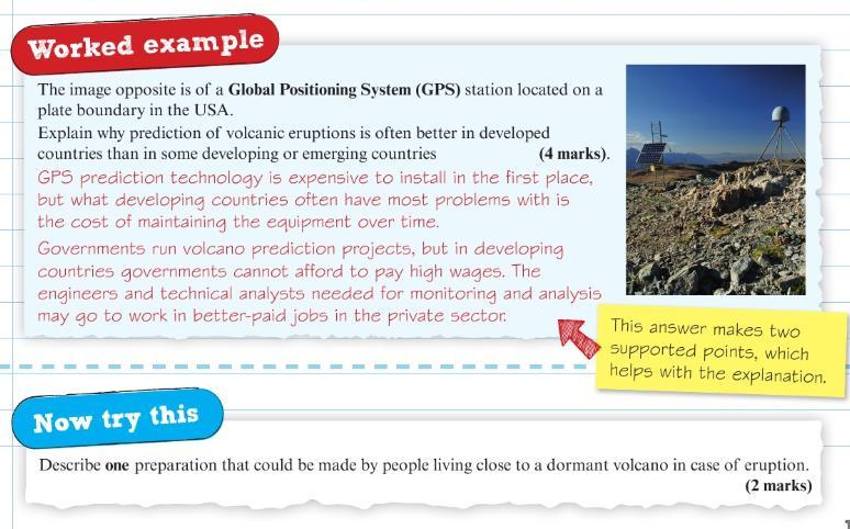
 5. Explain the secondary impacts of a named earthquake event that you have studied. (4 marks) 6.")
16 1. Explain why radioactive is important to tectonics (2 marks) 2. Explain how volcanoes form over hotspots. Use an annotated diagram in your answer (4 marks) 3. Define the term tsunami (1 mark) 4. Explain how a tsunami is caused. Use a diagram in your answer. (4 marks) 5. Explain the secondary impacts of a named earthquake event that you have studied. (4 marks) 6. Explain the primary impacts of a named volcanic event in a developing country you have studied (4 marks) 7. Describe one preparation that could be made by people living close to a dormant volcano in case of eruption (2 marks) 8. Explain how convection currents contribute to plate movement (3 marks)
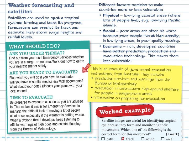
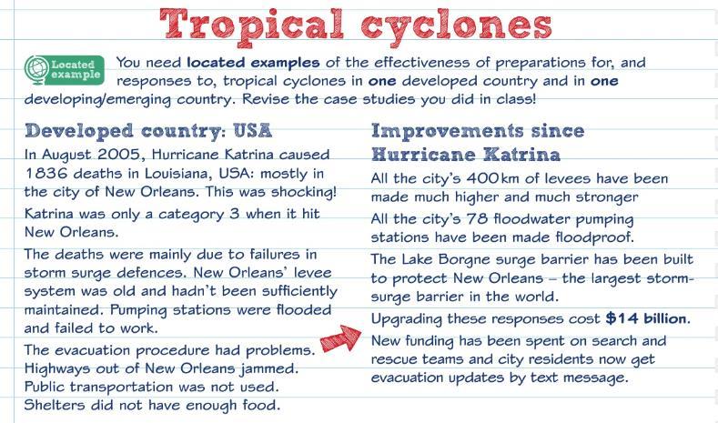
17 9. Explain two ways some earthquakes cause more damage and loss of life than others. (2 marks) 10. State two secondary impacts often caused by volcanic eruptions (2 marks) 11. Define the term short term relief (1 mark) 12. Describe how continental crust is different from oceanic crust. (2 marks) 13. Explain how volcanoes form away from plate boundaries (3 marks) 14. Describe the characteristics of shield volcanoes and composite volcanoes (3 marks) 15. Explain how earthwuakes are caused at convergent plate boundaries (3 marks) 16. Suggest why the effects of a tectonic hazard may be greater in an urban location than a rural one. (2 marks) 17. Scientists monitor gases and ground vibrations in tectonically active areas. Explain how this helps them to predict tectonic hazards (2 marks) 18. Preparation reduces the impact of tectonic hazards. Assess this statement using examples of hazards in countries of contrasting levels of development. (8 marks) Tropical Cyclones Checklist Learning Objective How do you feel? I understand where tropical cyclones are distributed in the world and how they form I understand how the global circulation of atmosphere leads to tropical cyclones and why they intensify/dissipate I understand the physical hazards that tropical cyclones can lead to and their impact on people I understand why some countries are more vulnerable to the impacts of tropical cyclones than others
18 I understand how countries prepare for and respond to tropical cyclones I understand how the effectiveness of preparation and response varies between a MEDC and a LEDC Key Words Keywords Aid Coriolis force Cumulonimbus clouds Economic impacts Eye of the storm Hurricane Predict Primary effects Probability Relief effort Risk zone Saffir-Simpson hurricane scale Secondary Definition short-term help such as food, given in emergency, or long-term help such as training in health care a strong force created by the Earth's rotation. It can cause storms, including hurricanes tall clouds created by the condensation of water vapour impacts on the wealth of an area the centre of a storm, consisting of calm, descending dense air the term given to a tropical cyclones in the USA and Caribbean saying that something will happen in the future. A scientific prediction is based on statistical evidence the direct impacts of event, usually occurring instantly the chance of an event happening help given by organisations or countries to help those facing an emergency areas assessed upon the likelihood of hazardous events happening, such as storm surges a scale that classifies hurricanes into five different categories according to their wind strength the indirect impacts of an event, usually occurring in

19 effects Social impacts Storm surge Tropical cyclone Typhoon the hours, weeks, months or years after the event the impacts of an event upon people a rapid rise in the level of the sea caused by low pressure and strong winds an area of low pressure with winds moving in a spiral around a calm central point called the eye of the storm winds are powerful and rainfall is heavy term given to a tropical cyclone in the western North Pacific Revision Material
20
21
22
23
 2. Explain how tropical cyclones form. (3 marks) 3. Explain one reason why some tropical storms intensify into cyclones (2 marks) 4.")
24 Tropical Cyclones Practice Questions 1. Developed countries provide much better protection against tropical cyclones than developing or emerging countries. Assess this statement with reference to named examples. (8 marks) 2. Explain how tropical cyclones form. (3 marks) 3. Explain one reason why some tropical storms intensify into cyclones (2 marks) 4. Explain the physical hazards associated with tropical cyclones. (3 marks) 5. Explain one reason why tropical cyclones present a particular danger to low-lying coastlines (3 marks) 6. Describe the human impact cyclones can have (2 marks) 7. Suggest why some countries are more vulnerable than others to the impact of tropical cyclones (2 marks) 8. Using a named example, describe one method used to prepare for future cyclones (2 marks)
25 9. Explain why the impact of tropical cyclones is greater in some places (3 marks) 10. State two features of tropical cyclones (2 marks) 11. State the main physical characteristic of the hurricane that is measured to give its category rating. (1 mark) 12. State two physical hazards of tropical cyclones (2 marks) 13. Explain one longer term impact on people that may results from a tropical cyclone (2 marks) 14. Describe two impacts that tropical cyclones can have on the environment (4 marks) Development Dynamics Learning Checklist Learning Objective How do you feel? I understand the contrasting ways to define development and how to measure development. I understand how countries at different levels of development have difference in their demographic data. I understand the causes and consequences of global inequalities: social, historical, economic and political. I understand how Rostow s modernisation theory and Frank s dependency theory explain why countries develop over time. I understand that characteristics of top-down and bottom up strategies in terms of their scale, aims, funding and technology. I understand the advantages and disadvantages of different approaches to development.(ngo, IGO, TNC) I understand the site, situation and connectivity of the megacity and its significance, in a national, regional and global context.
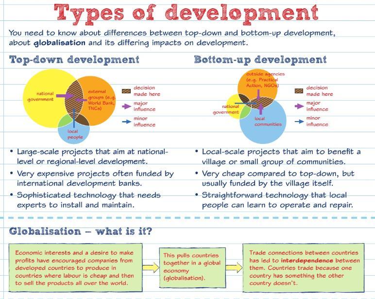
26 I understand the broad political, social, cultural and environmental context of a city example in its region and globally. I understand that key economic trend in globalisation since I understand the role of globalisation and government policy in the development of India. I understand how rapid economic change has contributed to demographic change, caused urbanisation and created different regions. I understand how the positive and negative impacts of development and globalisation I understand the impacts of economic development and globalisation on the environment. I understand how rapid economic development has changed the geopolitical influence and relationships with the EU and USA I understand the conflicting views of the costs and benefits of changing international relations and the role of foreign investment (TNC s) in the economic development. Key Words Biogas Keyword Definition a gas produced by the breakdown of organic matter, such as manure or sewage, in the absence of oxygen. It can be used as a biofuel Bottom-up development Cash crops Colonisation Commodities Containerization Core region Cycle of poverty experts work with communities to identify their needs, offer assistance and let people have more control over their lives, often run by non-governmental organisations crops sold for cash, directly from farmers to be exported and traded on global markets when another country takes over a foreign land and applies a system of power items of value that can be traded for money the transport of goods using container ships areas within a country that are important economic hubs, with high levels of employment and technological innovation a set of factors that cause continuous poverty unless intervention is made
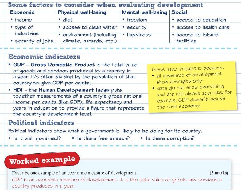
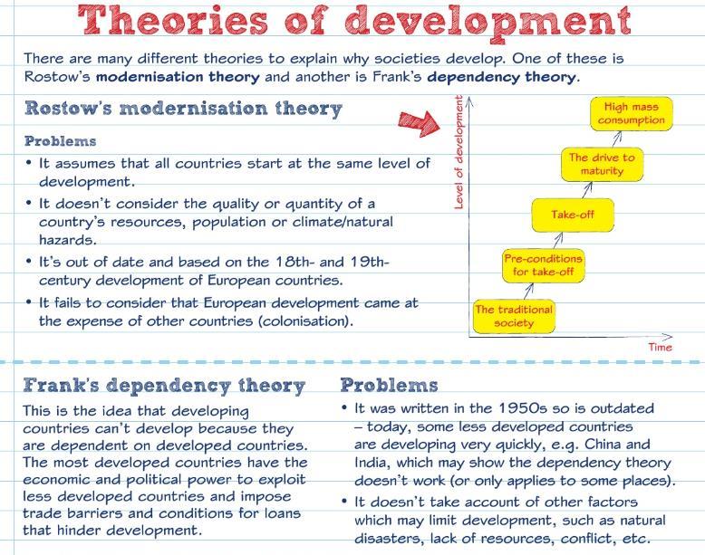
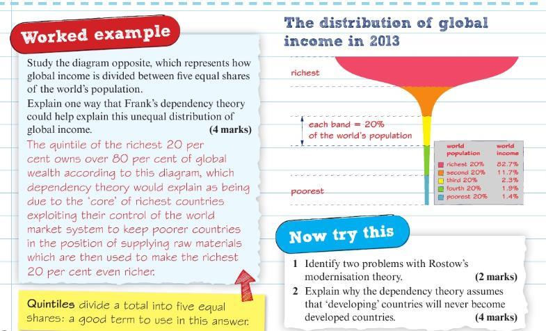
27 Demographic data Dependency ratio Development indicators Economic liberalisation Emerging countries Emerging economies Fertility rate Footloose Foreign Direct Investment (FDI) Frank s dependency theory Global north Global south Gross Domestic Product (GDP) Globalisation High Income Countries (HICs) Human Development Index (HDI) Industrialisation Infant mortality Infrastructure Inter-Governmental Organisations (IGOs) all data linked to population e.g. birth rate, death rate etc. the proportion of people below (aged 0-14) and above (over 65) normal working age. The lower the number, the greater the number of people who work and are less dependent measures of how a country is improving when a country's economy is given the freedom of a 'market economy', consumers and companies decide what people buy based on demand a country with high-to-medium human development, and recent economic growth countries that have recently industrialised and are progressing towards an increased role in the world economy average number of births per woman term used to describe companies that are able to locate anywhere there is high-quality communication links unrestricted flows of capital (money) from one country to another theory developed by economist André Frank that describes development using two types of global region (core and periphery) a group of wealthy countries found mainly in the Northern hemisphere a group of less wealthy countries found mainly in the Southern hemisphere the total value of *goods and *services produced by a country in one year increased connections between countries countries where employment is dominated by tertiary and quaternary sectors a standard means of measuring human development where a mainly agricultural society changes and begins to depend on manufacturing industries instead number of children per 1000 live births who die before their first birthday the basic services needed for an industrial country to operate e.g. roads, railways, power and water supplies, waste disposal, schools, hospitals, telephones and communication services governments and agencies working together
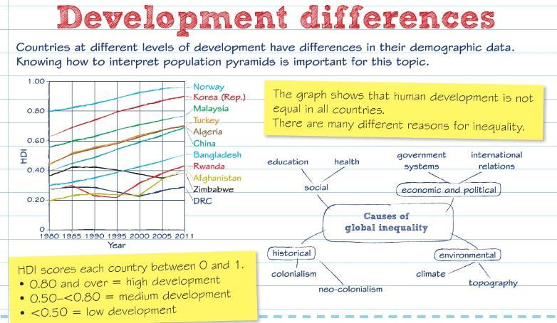
28 Intermediate technology Irrigation Knowledge economy Level of development Maternal mortality Life expectancy Low Income Countries (LICs) Middle Income Countries (MICs) Multiplier effect New economy Newly Industrialising Countries (NICs) Non-governmental organisations (NGOs) Outsourcing Population structure Primary products Rostow s theory Quaternary sector Rural-urban migration Secondary products Secondary sector uses low-tech solutions using local materials, labour and expertise to solve problems is the artificial watering of land that allows farming to take place an economy based on specialised knowledge and skill means a country's wealth (measured by its GDP), and its social and political progress (e.g. its education, health care or democratic process in which everyone can vote freely number of mothers per who die in childbirth average number of years a person can expect to live countries where employment is dominated by the primary sector e.g. farming countries dominated by the secondary sector (manufacturing), which often have large reserves of raw materials which has encouraged investment and growth e.g. Brazil and Chile when people or businesses move to an area and invest money on housing and services, which in turn creates more jobs and attracts more people economy based on the sale of services, rather than manufactured products the name given to countries that have very recently started to rapidly develop, such as Hong Kong, Singapore and Malaysia (the Asian Tigers ) NGOs work to make life better, especially for the poor. Oxfam, the Red Cross and Greenpeace are all NGOs using people in other countries to provide services if they can do so more cheaply e.g. call centres the number of each sex in each age group (e.g ), usually displayed in a population pyramid diagram raw materials theory by Walt Rostow about the economic growth of countries employment based on highly specialised knowledge and skill the movement of people from the countryside to the cities, normally to escape from poverty and to search for work manufactured goods employment based in manufacturing

29 Subsistence farming Tariff Terms of trade Tertiary sector Top-down development Trans National Companies (TNCs) World Trade Organisation (WTO) where farmers grow food to feed their families, rather than to sell additional cost added to the price of traded goods means the value of a country's exports relative to that of its imports employment based on services when decision-making about the development of a place is done by governments or large companies those which operate across more than one country a global organisation dedicated to making trade between countries easier Development Dynamics Revision Material
30
31
32
33
34
35
36
37
38
 3. Identify two problems with Rostow s modernisation theory (2 marks) 4.")
39 Development Dynamics Practice Questions 1. Explain some of the problems of only using economic measures of development (4 marks) 2. Explain why GDP per capita is a better indicator of development than just GDP (2 marks) 3. Identify two problems with Rostow s modernisation theory (2 marks) 4. Explain why the dependency theory assumes that developing countries will never become developed countries (4 marks) 5. Explain one way that governments contribute to globalisation (2 marks) 6. Explain the disadvantages of TNC investment in developing or emerging countries (4 marks) 7. Define GDP per capita (1 mark)
40 8. State two differences between the population structures in developed and developing or emerging countries (2 marks) 9. Describe how Rostow s theory can be used to help understand economic growth over time (3 marks) 10. Suggest why Frank s dependency theory may not apply to some countries today (3 marks) 11. State two characteristics of top-down development (2 marks) 12. Explain the positive impacts globalisation has had on different groups of people (4 marks) 13. Many TNCs have located their operations in emerging countries. Suggest how people in emerging countries can benefit from TNCs (3 marks) 14. Explain one feature of the political context of the emerging country you have studied (3 marks) 15. Describe how the natural environment and culture of your emerging country case study has influences its economic development (3 marks) 16. Explain the impact of globalisation on the environment of emerging countries (3 marks) 17. Referring to a named example, describe how levels of development vary within a country (2 marks) 18. For a named emerging country, assess to what extent globalisation had had a positive impact on the quality of life for the people living there (8 marks)
41
Global Atmospheric Circulation. Past climate change and natural causes. Global climate change and human activity
 GCSE Geography Edexcel B Revision Checklist Paper 1. Global Geographical Issues Topic 1. Hazardous Earth Key Idea I know/ understand The world s climate system Global Atmospheric Circulation Past climate
Enquiry question: How does the world s climate system function, why does it change and how can this be hazardous for people?
 Content Topic 1: Hazardous Earth Enquiry question: How does the world s climate system function, why does it change and how can this be hazardous for people? 1.1 The atmosphere operates as a global system
YEAR 9 GEOGRAPHY EXAMS
 YEAR 9 GEOGRAPHY EXAMS This exam will assess the topics covered so far this year: Topic 3: Challenges of an urbanising world Topic 1: Hazardous Earth (climate and cyclones) It will also check understanding
Topic 4: Changing cities
 Topic 4: Changing cities Overview of urban patterns and processes 4.1 Urbanisation is a global process a. Contrasting trends in urbanisation over the last 50 years in different parts of the world (developed,
Brazil The country of Brazil is used to consider the different climatic conditions that can occur and why that is. Sport
 SUBJECT : Geography 2014 15 Yr7 What is geography? Students are introduced to the topic of geography and why it is so important to our everyday lives. Within the subject students explore the differences
Year 11 Geography. Paper 2 UK Geographical Issues. Exam Revision Booklet
 Year 11 Geography Paper 2 UK Geographical Issues Exam Revision Booklet Contents Page Topic Exam Command Words How to structure your answers UK s Physical Landscape Checklist UK s Physical Landscape Key
Geography GCSE. Year 9 Term and Topic Unit Content Homework Opportunities
 Geography GCSE Year 9 Term and Topic Unit Content Homework Opportunities Autumn Term 1: Geographical Skills Autumn Term 2: Tectonic Hazards Spring Term 1: Ecosystems Rainforest Students are required to
SUBJECT : Geography Topics: Learning Outcomes:
 SUBJECT : Geography 2016-17 Yr7 What is geography and Britain? Students are introduced to the topic of geography and why it is so important to our everyday lives. Within the subject students explore the
KS3 Geography Year 8 Core Questions
 Geography Department KS3 Geography Year 8 Name: Class: Teacher: Core Questions These core questions cover key facts for each of the units you will study during year 8. It is an important revision skill
Introduction to Development. Indicators and Models
 Introduction to Development Indicators and Models First World vs. Third World Refers to economic development Diversity and complexity of economy High per capita income Developed during the Cold War First
GCSE 4231/01 GEOGRAPHY
 Surname Centre Number Candidate Number Other Names 0 GCSE 4231/01 GEOGRAPHY (Specification A) FOUNDATION TIER UNIT 1 Core Geography A.M. THURSDAY, 14 June 2012 1 3 4 hours For s use Question 1 Question
SUBJECT: YEAR: Half Term:
 Geography 9 1 Introduction to Population and population distribution begin to explain the pattern of population distribution. describe and explain the pattern of population distribution at a range of scales.
Guidance for GEOGRAPHY End of Year Examination 2016
 Guidance for GEOGRAPHY End of Year Examination 2016 The End of Year Examination takes place in Week 4 of the Summer Term. The Geography Examination will last 50 minutes. The Examination will include questions
UK s Evolving Physical Landscape
 Paper 1 Global Issues Paper 2 UK Issues Paper 3 - Making Geographical Decisions Have you ever wondered 1. How does the world s climate system work and why is climate change becoming such a hazard? 2. What
Stratford School Academy Schemes of Work GEOG: RESTLESS EARTH
 Case studies Drawing maps, graphs and diagrams. Stratford School Academy Year 10 Restless Earth Geography: YEAR 10 Restless Earth Number of weeks Content of the unit Assumed prior learning (tested at the
Edexcel GCSE Geography B Scheme of Work. Component 1, Topic 1: Hazardous Earth
 Edexcel GCSE Geography B Scheme of Work Component 1, Topic 1: Hazardous Earth Introduction Edexcel GCSE Geography B Investigating Geographical Issues offers an issues-based approach to the content and
World Geography. WG.1.1 Explain Earth s grid system and be able to locate places using degrees of latitude and longitude.
 Standard 1: The World in Spatial Terms Students will use maps, globes, atlases, and grid-referenced technologies, such as remote sensing, Geographic Information Systems (GIS), and Global Positioning Systems
CNCS GCSE. Case Study and Exam Question Revision Booklet
 1 CNCS GCSE Case Study and Exam Question Revision Booklet Note: there is no single way to respond to a 9 mark question attached is guidance only (Grades 7-9 will require judgement and will need to be more
New GCSE Geography AQA
 Learning Checklist Half Term 1 26 th September 3 rd October 10 th October 17 th October 1.1.1 Tectonic Hazards Plate tectonics theory. Global distribution of earthquakes and volcanic eruptions and their
INDIANA ACADEMIC STANDARDS FOR SOCIAL STUDIES, WORLD GEOGRAPHY. PAGE(S) WHERE TAUGHT (If submission is not a book, cite appropriate location(s))
 WHERE TAUGHT (If submission is not a book, cite appropriate location(s))") Prentice Hall: The Cultural Landscape, An Introduction to Human Geography 2002 Indiana Academic Standards for Social Studies, World Geography (Grades 9-12) STANDARD 1: THE WORLD IN SPATIAL TERMS Students
Prentice Hall: The Cultural Landscape, An Introduction to Human Geography 2002 Indiana Academic Standards for Social Studies, World Geography (Grades 9-12) STANDARD 1: THE WORLD IN SPATIAL TERMS Students
Edexcel GCSE Geography B
 Comparing the 2012 AQA specification with the new 2016 specification This document is designed to help you compare the existing 2012 AQA specification with the new 2016 specification. The document gives
OCR 2008 AS and A level Geography Specification Mapping Guide
 OCR 2008 AS and A level Geography Specification Mapping Guide Contents Introduction Error! Bookmark not defined. Specification map: 2008 OCR AS and A level Geography 3 What's new? 10 Introduction This
GFS Geography Medium Term Plan Year 7 SUMMER
 Context: This unit investigates the processes that cause the Earth s plates to move and the landforms that result. It then investigates the interaction between people and these potentially hazardous environments.
Edexcel GCSE Geography A
 Edexcel GCSE Comparing the 2012 AQA GCSE specification with the new 2016 Edexcel specification This document is designed to help you compare the existing 2012 AQA GCSE specification (9030) with the new
International Development
 International Development Discipline/Multi-discipline or trans-disciplinary field Tahmina Rashid Associate Professor, International Studies What is Development? a. Development as a state or condition-static
Geography Exams. RAG rate The Challenge of Natural Hazards
 Geography Exams You will sit three papers, Paper 1 will last 1 hour 30 minutes and will examine your understanding of The Challenge of Natural Hazards, The Living World and Physical Landscapes in the UK.
World Geography Fall 2013 Semester Review Project
 Reporting Category RC 1: History, Government and Citizenship Standard WG.1 History. The student understands how geography and processes of spatial exchange (diffusion) influenced events in the past and
KS3 Geography Course Cranbrook Education Campus E Jacobs. Weather & Climate
 KS3 Course Structure @ Cranbrook Education Campus E Jacobs Term Year 7 Term 1 What is Term 2 Term 3 Sustainability Weather & Climate Rainforests Coasts Term Year 8 Term 1 Restless Earth Term 2 Term 3 Population,
Tectonic Processes and Hazards Enquiry Question 1: Why are some locations more at risk from tectonic hazards?
 Tectonic Processes and Hazards Enquiry Question 1: Why are some locations more at risk from tectonic hazards? Key words Basalt Andesite Rhyolite Benioff Zone Subduction zone Crustal fracturing Definition
Paper Reference. Paper Reference(s) 1312/2F Edexcel GCSE Geography A Foundation Tier. Monday 11 June 2007 Afternoon Time: 1 hour 15 minutes
 1312/2F Edexcel GCSE Geography A Foundation Tier. Monday 11 June 2007 Afternoon Time: 1 hour 15 minutes") Centre No. Paper Reference Surname Initial(s) Candidate No. 1 3 1 2 2 F Signature Paper Reference(s) 1312/2F Edexcel GCSE Geography A Foundation Tier Paper 2F Monday 11 June 2007 Afternoon Time: 1 hour
Centre No. Paper Reference Surname Initial(s) Candidate No. 1 3 1 2 2 F Signature Paper Reference(s) 1312/2F Edexcel GCSE Geography A Foundation Tier Paper 2F Monday 11 June 2007 Afternoon Time: 1 hour
NORTH VISTA SECONDARY SCHOOL HUMANITIES DEPARTMENT SECONDARY 3 EXPRESS HUMANITIES (GEOGRAPHY) 2272/02 CONTENT OUTLINE Term 1
 2272/02 CONTENT OUTLINE Term 1") NORTH VISTA SECONDARY SCHOOL HUMANITIES DEPARTMENT SECONDARY 3 EXPRESS HUMANITIES (GEOGRAPHY) 2272/02 CONTENT OUTLINE 2019 Term 1 Week Learning Outcomes Skills to be covered Assignment Test Project 1-2
NORTH VISTA SECONDARY SCHOOL HUMANITIES DEPARTMENT SECONDARY 3 EXPRESS HUMANITIES (GEOGRAPHY) 2272/02 CONTENT OUTLINE 2019 Term 1 Week Learning Outcomes Skills to be covered Assignment Test Project 1-2
World Geography TEKS 2nd Nine Weeks. Unit of Study Regional Studies; U.S. and Canada Regional Studies; Latin America; and Europe
 World Geography TEKS 2nd Nine Weeks Unit of Study Regional Studies; U.S. and Canada Regional Studies; Latin America; and Europe 1) History. The student understands how geography and processes of spatial
Year 8 Level: 5-8 GEOGRAPHY Time: 1:30min
 Year 8 Level: 5-8 GEOGRAPHY Time: 1:30min Name: Class: Answer all questions in the space provided. 1. Label the diagram below using the following words; (4) mantle, crust, outer core, inner core 2. Write
Edexcel GCSE Geography B
 Comparing the specification with the new 2016 specification This document is designed to help you compare the existing specification 2G01 with the new 2016 specification. The document gives an overview,
NATIONAL SPORTS SCHOOL ST BENEDICT COLLEGE
 NATIONAL SPORTS SCHOOL ST BENEDICT COLLEGE Mark HALF-YEARLY EXAMINATION 2013/14 FORM 2 GEOGRAPHY (Levels 8 7 6 5) TIME: 1h 30 min Name: Class: Answer ALL the questions. 1. TRUE or FALSE? Put a in the correct
A Level Geography Transition Pack
 Coasts (to go to Mr. Hicks) Independent Research Tasks Complete the tasks below to help you see the bigger picture of the coasts topic. 1. What effect will sea level rise have on coastlines? 2. http://www.theguardian.com/environment/sea-level
CHANGING PHYSICAL AND HUMAN LANDSCAPES SAMPLE ASSESSMENT MATERIALS
 GCSE GEOGRAPHY A Sample Assessment Materials 5 GCSE GEOGRAPHY A COMPONENT 1 CHANGING PHYSICAL AND HUMAN LANDSCAPES SAMPLE ASSESSMENT MATERIALS 1 hour 30 minutes Section Question Mark SPaG A B 1 2 Either
Unit 1 Living with the Physical Environment
 Unit 1 Living with the Physical Environment Topic Example / Case Study Example Tectonic Hazards Chile Nepal Weather Hazards Typhoon Haiyan Somerset Floods Climate Change Ecosystems Tropical Rainforests
GCSE 4231/01 GEOGRAPHY (Specification A) FOUNDATION TIER UNIT 1: Core Geography
 FOUNDATION TIER UNIT 1: Core Geography") Surname Centre Number Candidate Number Other Names 0 GCSE 4231/01 GEOGRAPHY (Specification A) FOUNDATION TIER UNIT 1: Core Geography P.M. TUESDAY, 13 May 2014 1 hour 45 minutes For s use Question Maximum
Surname Centre Number Candidate Number Other Names 0 GCSE 4231/01 GEOGRAPHY (Specification A) FOUNDATION TIER UNIT 1: Core Geography P.M. TUESDAY, 13 May 2014 1 hour 45 minutes For s use Question Maximum
World Geography Mid Term Review 2016
 World Geography Mid Term Review 2016 1.Latitude and Longitude Lines of latitude run and. The zero-degree line is the. Line of longitude run and. The zero degree line is called the. 2. Map Projections What
Year 11 Geography. Paper 2 UK Geographical Issues. Mock Exam Revision Booklet
 Year 11 Geography Paper 2 UK Geographical Issues Mock Exam Revision Booklet Contents Page Topic Exam Command Words How to structure your answers UK s Physical Landscape Checklist UK s Physical Landscape
Year 8 Practice Questions for Summative Assessment. NAME:...
 Year 8 Practice Questions for Summative Assessment. NAME:... Earthquakes and Volcanoes 1. (a) The diagram below shows a simple cross section of the Earth. Complete the labels. (b) Name an earthquake you
What is a natural hazard?
 What is a natural hazard? Give me a definition not examples These words might help you A natural hazard is a naturally occurring event that might have a negative effect on people or the environment. Location
THEME 1: Landscape and Physical Processes
 What do I need to know for each topic? THEME 1: Landscape and Physical Processes Identify distinctive landscapes as being upland, lowland, coastal and river. Describe how landscapes can be managed e.g.
Chapter Introduction Lesson 1 Earthquakes Lesson 2 Volcanoes Chapter Wrap-Up
 Chapter Introduction Lesson 1 Earthquakes Lesson 2 Volcanoes Chapter Wrap-Up What causes earthquakes and volcanic eruptions? What do you think? Before you begin, decide if you agree or disagree with each
Candidate Name Centre Number Candidate Number CHANGING PHYSICAL AND HUMAN LANDSCAPES SAMPLE ASSESSMENT MATERIALS
 GCSE GEOGRAPHY Sample Assessment Materials 5 Candidate Name Centre Number Candidate Number 0 GCSE GEOGRAPHY UNIT 1 CHANGING PHYSICAL AND HUMAN LANDSCAPES SAMPLE ASSESSMENT MATERIALS 1 hour 30 minutes Section
World Geography Review Syllabus
 Purpose Class: World Geography Review Syllabus This course is designed to help students review and remediate their understanding major themes, concepts, and facts connected to the study World Geography.
New A-Level Physical Geography
 Half Term 1 3.1 Physical Geography: 3.1.5 Hazards: Plate Tectonics This optional section of our specification focuses on the lithosphere and the atmosphere, which intermittently but regularly present natural
Year 11 Geography GCSE Assessment Booklet Section A: The challenge of natural hazards
 Year 11 Geography GCSE Assessment Booklet Section A: The challenge of natural hazards Question Mark & Grade 9 1 Explain why the majority of earthquakes and volcanoes occur at plate margins (6 marks) Choose
This table connects the content provided by Education Perfect to the NSW Syllabus.
 Education Perfect Geography provides teachers with a wide range of quality, engaging and innovative content to drive positive student learning outcomes. Designed by teachers and written by our in-house
Seva Excellence Virtues Aspiration
 Geography Curriculum for years 7, 8 and 9 According to Dr Rita Gardner, Director of the Royal Geographical Society, There has never been a better or more important time to study geography. With growing
NAME: FORM: YEAR 6 SUMMER EXAM REVISION QUESTIONS 2017
 NAME: FORM: YEAR 6 SUMMER EXAM REVISION QUESTIONS 2017 YEAR 6 SUMMER EXAM REVISION QUESTIONS The exam will be based upon the work that you have covered so far in Year Six and will have a question on each
A Living Planet. The Earth Inside and Out
 A Living Planet The Earth Inside and Out Planet Earth Earth s Rotation, Revolution, and Tilt Most of Earth s energy comes from the Sun, which we call solar energy. Imagine that the Earth has an imaginary
Features of Tectonic Plates
 Features of Tectonic Plates PowerPoint 12.2 The Earth s Layers Crust Brittle Continental crust composed mainly of granite Oceanic crust composed mainly of basalt Mantle Denser than the crust Upper is molten
Year 9 Revision. The exam will be based on two topics: Natural hazards and Population. The Exam
 Year 9 Revision The exam will be based on two topics: Natural hazards and Population This document is designed to help you revise. You should use it alongside your class notes. In places there are some
Describe the layers of the Earth Understand what plates are and how they move
 Lesson links Lesson 1 layers of the earth and plate boundaries Lesson 2 How and why a volcano erupts Lesson 3 The impacts of a volcanic eruption Mt St Helen s (learning Milestone) Lesson 4 How an earthquake
Of topic specific knowledge and understanding To encourage progressive development in 'thinking geographically'
 [August 2012] Content exemplars 1. Broad description of the content: Single paragraph, written with technical precision Content rigour (avoiding generic statements) Identifying the core of essential knowledge
Year 4 Geography Revision Pack Summer 2018 Name
 Year 4 Geography Revision Pack Summer 2018 Name Welcome to your geography revision pack for the upcoming Summer exams. Everything that we have been working on in lessons since Christmas will be covered
Amarillo ISD Social Studies Curriculum
 Amarillo Independent School District follows the Texas Essential Knowledge and Skills (TEKS). All of AISD curriculum and documents and resources are aligned to the TEKS. The State of Texas State Board
Plate tectonics. Temperature increases towards the centre
 Temperature increases towards the centre Plate tectonics Structure of the Earth Crust Two layers of rock that move on top of the mantle 1. Oceanic Lithosphere heavy rock created at constructive plate boundaries
Earth and Space Science Semester 2 Exam Review. Part 1. - Convection currents circulate in the Asthenosphere located in the Upper Mantle.
 Earth and Space Science 2015 Semester 2 Exam Review Part 1 Convection -A form of heat transfer. - Convection currents circulate in the Asthenosphere located in the Upper Mantle. - Source of heat is from
Unit 1 Dynamic Planet Topic 1 Restless earth
 Unit 1 Dynamic Planet Topic 1 Restless earth Instructions Complete this revision sheet using your exercise book and text book. Store this revision sheet in your revision folder once it has been checked
Unit Two: Development & Globalization
 Unit Objectives Unit Two: Development & Globalization Students gain an understanding of the definitions of and differences in less economically developed countries and more economically developed countries
Paper Reference. Paper Reference(s) 1312/4H Edexcel GCSE Geography A Higher Tier. Monday 11 June 2007 Afternoon Time: 1 hour 15 minutes
 1312/4H Edexcel GCSE Geography A Higher Tier. Monday 11 June 2007 Afternoon Time: 1 hour 15 minutes") Centre No. Paper Reference Surname Initial(s) Candidate No. 1 3 1 2 4 H Signature Paper Reference(s) 1312/4H Edexcel GCSE Geography A Higher Tier Paper 4H Monday 11 June 2007 Afternoon Time: 1 hour 15
Centre No. Paper Reference Surname Initial(s) Candidate No. 1 3 1 2 4 H Signature Paper Reference(s) 1312/4H Edexcel GCSE Geography A Higher Tier Paper 4H Monday 11 June 2007 Afternoon Time: 1 hour 15
Plate Tectonics. These icons indicate that teacher s notes or useful web addresses are available in the Notes Page.
 Plate Tectonics These icons indicate that teacher s notes or useful web addresses are available in the Notes Page. This icon indicates the slide contains activities created in Flash. These activities are
QU: How do we define natural hazards? AIM: To explain community vulnerability and resilience using established geographical models.
 QU: How do we define natural hazards? AIM: To explain community vulnerability and resilience using established geographical models. ST: Account for the difference in eruption height and explosivity of
Earth is over 1200 km thick and has four distinct layers.
 1 2.2 F e a ture s o f P la te T e c to nic s Earth is over 1200 km thick and has four distinct layers. These layers are the crust, mantle (upper and lower), outer core, and inner core. Crust outer solid
TO GO TO ANY OF THE PAGES LISTED BELOW, CLICK ON ITS TITLE
 TO GO TO ANY OF THE PAGES LISTED BELOW, CLICK ON ITS TITLE CHAPTER 6 Plate Tectonics 1 6-1 What is continental drift? 2 6-2 Why is the seafloor spreading? 3 6-3 What evidence supports seafloor spreading?
Cambridge International Examinations Cambridge International General Certificate of Secondary Education
 Cambridge International Examinations Cambridge International General Certificate of Secondary Education *8962500270* GEOGRAPHY 0460/22 Paper 2 October/November 2016 Candidates answer on the Question Paper.
Assessment Objectives Grid for Geography - G1. Summer Application Skills Total. (a) (b) (c) (a)
 (b) (c) (a)") Assessment Objectives Grid for Geography - G1 Summer 2014 Question 1 Knowledge and Understanding Application Skills Total Key Question (a) 0 2 3 5 1.5 (b) 8 2 10 1.3 (c) 7 3 10 1.4 15 7 3 25 Question 2
Assessment Objectives Grid for Geography - G1 Summer 2014 Question 1 Knowledge and Understanding Application Skills Total Key Question (a) 0 2 3 5 1.5 (b) 8 2 10 1.3 (c) 7 3 10 1.4 15 7 3 25 Question 2
GCSE Geography Assessment Workbook The Restless Earth
 GCSE Geography Assessment Workbook The Restless Earth Name: Contents Page Aims and Objectives page 3 Command Terms Glossary page 4-5 Marksheet page 6-8 Section 1: One & Two mark questions page 9-12 Section
The Theory of Plate Tectonics
 Plate Tectonics Objectives Describe how plates move. Explain the features of plate tectonics. Describe the types of plate boundaries and the features that can form and events that can occur at each. The
Plate Tectonics. Chapter 8
 Plate Tectonics Chapter 8 Vocabulary Crust Mantle Core Lithosphere Continental Drift Plate Tectonics Plate Boundary Fault What Are The Earth s Layers Made Of? Atmosphere: Contains nitrogen, oxygen, carbon
I CAN DO sheets Southchurch High School
 Rate your confidence in the following topic content and geographical skills by ticking the appropriate column beside each point: Red = Not confident Yellow = Almost there Green = Confident Changing landscapes
Unit 4 Lesson 4 Volcanoes. Copyright Houghton Mifflin Harcourt Publishing Company
 Magma Magic What is a volcano? A volcano is any place where gas, ash, or melted rock come out of the ground. Many volcanoes are dormant, meaning an eruption has not occurred in a long period of time. What
Vocabulary Words. theory continental drift fault magma lava. weathering glacier erosion deposition delta
 Earth s Landforms Vocabulary Words theory continental drift fault magma lava weathering glacier erosion deposition delta Theory: A possible explanation. Continental drift: The continuing movement of the
AQA A level Geography (2016) Mapping Guide
 Mapping Guide") AQA A level Geography (2016) Mapping Guide At a glance comparison of the AQA and Edexcel specifications...page 2 Support for teaching Edexcel AS and A level Geography...Page 3 What is the same?...page
AQA A level Geography (2016) Mapping Guide At a glance comparison of the AQA and Edexcel specifications...page 2 Support for teaching Edexcel AS and A level Geography...Page 3 What is the same?...page
KS3 Geography Year 8 Core Knowledge
 Geography Department KS3 Geography Year 8 Name: Class: Teacher: Core Knowledge These core questions cover key facts for each of the units you will study during year 8. It is an important revision skill
Ch. 9 Review. Pgs #1-31 Write Questions and Answers
 Ch. 9 Review Pgs. 356-357 #1-31 Write Questions and Answers 356-357 #1-5 Answers 1. The layer of the upper mantle that can flow is the: A - Asthenosphere 2. Most scientists rejected Wegener s theory of
What is the theory of plate tectonics? Lesson 1 Lesson 2 Lesson 3
 Name Plate Tectonics What is the theory of plate tectonics? Date Before You Read Before you read the chapter, think about what you know about plate tectonics Record your thoughts in the first column Pair
Word Cards. 2 map. 1 geographic representation. a description or portrayal of the Earth or parts of the Earth. a visual representation of an area
 Name: Date: Hour: Word Cards 1 geographic representation a description or portrayal of the Earth or parts of the Earth Example: A map is a representation of an actual location or place. 2 map a visual
Chapter 2 - Lessons 1 & 2 Studying Geography, Economics
 Chapter 2 - Lessons 1 & 2 Studying Geography, Economics How does geography influence the way people live? Why do people trade? Why do people form governments? Lesson 1 - How Does Geography Influence the
GIRLS SECON DARY - MRIEĦEL HALF-YEARLY EXAMINATIONS 2016/2017
 GIRLS SECON DARY - MRIEĦEL HALF-YEARLY EXAMINATIONS 2016/2017 FORM: 4 Time: 1 ½ hrs Name: Class: Section A: Weather and Climate 1. Place the following weather conditions under the appropriate heading.
12.2 Plate Tectonics
 12.2 Plate Tectonics LAYERS OF THE EARTH Earth is over 1200 km thick and has four distinct layers. These layers are the crust, mantle (upper and lower), outer core, and inner core. Crust outer solid rock
Exploring Geography. Chapter 1
 Exploring Geography Chapter 1 The Study of Geography Geography is the study of where people, places, and things are located and how they relate to each other. Greek meaning writing about or describing
Year 11: Possible Extended Questions. 1. Using examples explain why it is difficult to predict future population growth.
 Year 11: Possible Extended Questions Population Dynamics 1. Using examples explain why it is difficult to predict future population growth. 2. Explain why the future growth of world population is hard
iv vi x Using maps 2 Using images and analysing data 6 Using new technologies in geography 8
 Contents Exam board specification map Introduction Topic checker iv vi x Geographical skills Using maps 2 Using images and analysing data 6 Using new technologies in geography 8 Natural hazards Tectonic
Tectonic Plates Test Study Guide Answers
 Tectonic Plates Test Study Guide Answers Weathering and Erosion 1. What is the difference between weathering and erosion? Weathering is the breakdown of earth materials and erosion is the movement of earth
Campus: VALLEY VIEW HIGH SCHOOL Content Area: Social Studies
 Campus: VALLEY VEW HGH SCHOOL : Map Name: Grading Period: 1 1A 21A 21B 21D 21E 22A 22B 22C 22D 3A 3B Description, TEKS Concept and Description analyze the effects of physical and human ggraphic patterns
Coimisiún na Scrúduithe Stáit State Examinations Commission
 2009. M24 Coimisiún na Scrúduithe Stáit State Examinations Commission LEAVING CERTIFICATE EXAMINATION, 2009 GEOGRAPHY HIGHER LEVEL FRIDAY 5 JUNE AFTERNOON 2.00 to 4.50 Examination Number For the Examiner
Subject Overview
 Subject Overview 2018 2019 Department Name: Head of Department: Subject Teachers: Accommodation and Resources: Geography Mrs J Thorne Mr D Jinks Miss A Smith Geography is based in 3 main classrooms. Each
9768 GEOGRAPHY. Mark schemes should be read in conjunction with the question paper and the Principal Examiner Report for Teachers.
 CAMBRIDGE INTERNATIONAL EXAMINATIONS Pre-U Certificate www.xtremepapers.com MARK SCHEME for the May/June 2014 series 9768 GEOGRAPHY 9768/01 Paper 1 (Geographical Issues), maximum raw mark 105 This mark
ENVIRONMENTAL AND DEVELOPMENT ISSUES SAMPLE ASSESSMENT MATERIALS
 GCSE GEOGRAPHY Sample Assessment Materials 41 GCSE GEOGRAPHY UNIT 2 ENVIRONMENTAL AND DEVELOPMENT ISSUES SAMPLE ASSESSMENT MATERIALS 1 hour 30 minutes Section Question Mark SPaG A B 1 2 either 3 or 4 28
Source:
 Source: http://www.pastforward.ca/perspectives/columns/10_02_05.htm At 16:53, on Wednesday, January 12th, 2010, a devastating 7.0 earthquake struck Haiti's capital, Port-au-Prince. The earthquake left
OIB GEOGRAPHY SYLLABUS. Theme
 OIB GEOGRAPHY SYLLABUS Summary of Themes Theme 1) Different views and interpretations of world organisation through the study of maps focusing on issues of globalisation and development; to include a critical
2018 Geography Mock Examination
 2018 Geography Mock Examination Your Geography mock examination will test your understanding of Paper 1 (Living with the physical environment) and Section B (Fieldwork) from Paper 2. Attached are the necessary
Unit 6: Development and Industrialization. Day 1: What is development?
 Unit 6: Development and Industrialization Day 1: What is development? What is Development? The process of improving the material conditions of people through the diffusion of knowledge and technology More
KNES Geography Course Outline. Year 9
 KNES Geography Course Outline Year Geography is the study of Earth s landscapes, peoples, places and environments. It is, quite simply, about the world in which we live. Geography is unique in bridging
Marr College Geography Department. Can-Do Checklist for Higher Geography
 Marr College Geography Department Can-Do Checklist for Higher Geography The Higher Geography exam consists of one paper. It is out of a total of 60 marks. The total time for the paper is 2 hours 15 minutes.
Subject Area: Geography
 Long Term Planning Overview Key Stage 3 Subject Area: Geography Academic : 08-9 7 Assessment Your Island Home the physical and human geography of the UK and will investigate weather patterns, population