Year 11 Geography. Paper 2 UK Geographical Issues. Exam Revision Booklet
|
|
|
- Gordon Moody
- 5 years ago
- Views:
Transcription


1 Year 11 Geography Paper 2 UK Geographical Issues Exam Revision Booklet
2 Contents Page Topic Exam Command Words How to structure your answers UK s Physical Landscape Checklist UK s Physical Landscape Key Words UK s Physical Landscape Revision Material UK s Physical Landscape Practice Questions Coasts Learning Checklist Coasts Key Words Coasts Revision Material Coasts Practice Questions UK s Human Landscape Checklist UK s Human Landscape Key Words UK s Human Landscape Revision Material UK s Human Landscape Practice Questions Geographical Investigations (Fieldwork) Checklist Geographical Investigations (Fieldwork) Key Words Geographical Investigations (Fieldwork) Revision Material Geographical Investigations (Fieldwork) Practice Questions Page Number
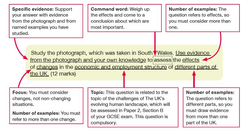
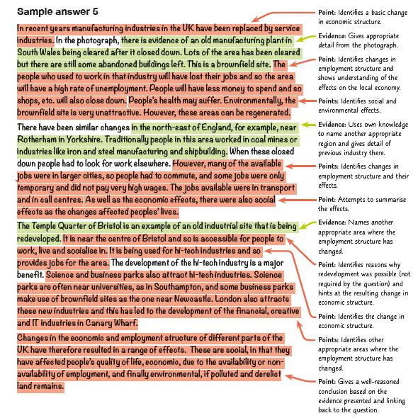
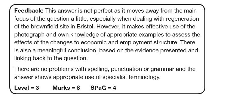
3 Command Word Identify/ Name/ State Exam Command Words Marks Meaning Example Question Sentence Starters/ Hints 1 Find/give a simple statement Identify the landform in the photo Define 1 Give the meaning Define the term fertility rate Calculate 1 or 2 Work out Calculate the mean age of a group of people Label 1 or 2 Print the name of/ Write on a map or diagram Draw 2 or 3 Sketch/ Draw a line Compare 3 Find the similarities and differences Label 2 features of the river in Figure 2 Draw a line to complete the graph in Figure 3 Compare the rate of population growth in 2 cities I can see. An example is This means. The term? means. Show your working out Use correct Geographical terminology Always draw in pencil This figure shows As you can see One similarity/ one difference that is evident Describe 2 or 3 What is it like/ Trends on graphs Describe the trends shown in Figure 1. Describe the increase in population Use PQE: Pattern Quantity Exceptions Use GCSE General Comment Specific Example or Exceptions Explain 2, 3 or 4 Give reasons why it happens Explain the formation of a meander PEE paragraphs This is because.. Suggest 2,3 or 4 Give a wellreasoned guess to explain Suggest reasons why flooding has become more frequent along this river One possible reason It may be that In some cases we might Assess 8 Weigh up which is most/least important Evaluate 8 Give a judgement: which is most/ least effective Select & Justify 12 Select and then give evidence to support Assess the need for coastal management along a stretch of coastline you studied Evaluate the methods used in collecting data in your fieldwork Select and justify the best option for the future of On one hand Some may suggest that The most important reason could be Evidence suggests Although In certain situations Contributed to Overall The reason for this Significant impacts However To conclude Some may suggest
4 How to structure your answers 1 mark Identify, State, Name, Define, Calculate, Label Write a simple sentence or just a few words 2 marks Calculate You must show your workings out Label Label/annotate at least 2 main things Draw Draw a diagram and label/annotate at least 2 main parts Describe state 2 things Explain Point, Explain Suggest Point, Development 3 marks Draw Draw a diagram and label/annotate at least 3 main parts Compare At least one difference and one similarity plus another of your choice Describe state 3 things Explain & Suggest Point & 2 development or Point, Development, Point 4 marks Explain & Suggest Point & Development x 2 8 marks 4 marks for explanation & 4 marks for use of evidence Assess Explanation Requires you to explain which you think is the most important aspect of something in relation to others. Give 4 reasons for your decision or opinion Use of evidence May require you to find evidence in a figure and/or use your own knowledge to give evidence for your decisions. Learn case studies and named examples. Evaluate E.g. Global responses to climate change are more important than local response because. Require you to explain how successful you think something is or has been. Give 4 reasons for your decision. E.g. India has been successful in managing the environmental impacts of slims in Mumbai because Require you to use your own knowledge of the world to answer the question and provide evidence. Learn case studies and named examples.
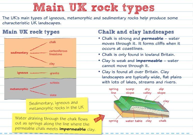
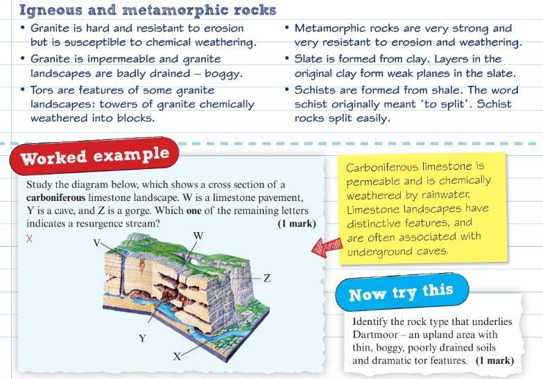
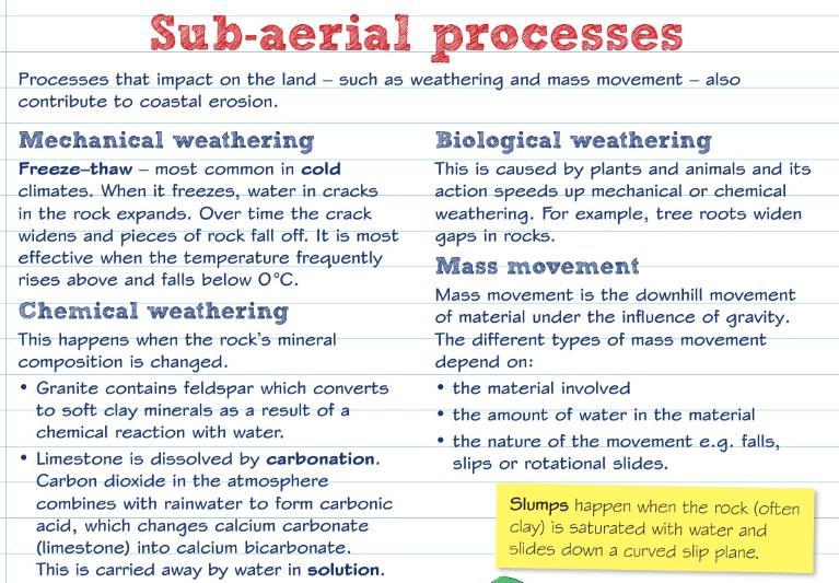
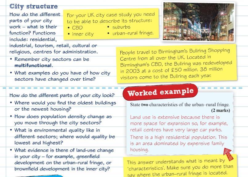
5 UK s Physical Landscape Checklist Learning Objective I understand the role of geology, past tectonics and glacial processes in the development of upland and lowland areas. I understand the characteristics and distribution of the UK s main rock types: sedimentary, igneous, and metamorphic. I understand why distinctive upland and lowland landscaped result from interaction of physical processes: weathering and climatological, post-glacial river and slope processes. I understand why distinctive landscape result from human activity over time. (Agriculture forestry, settlement) UK s Physical Landscape Key Words Keyword Erosion Faults Glaciated Gradient Igneous Interlocking spurs Limestone Lowland landscape Definition wearing away the landscape large cracks caused by past tectonic movements formed or once covered by glaciers or ice sheets Slope Rock type formed from lavas and deep magmas. They were once molten, then cooled and crystallised hills that stick out on alternate sides of a V-shaped valley, like the teeth of a zip a pale grey rock consisting of crushed shells of corals that lived in tropical seas 300 million years ago an area of flat land that is at, near or below sea level, which in the UK usually consists of younger and less resistant sedimentary rocks
6 Mass movement Metamorphic Prevailing wind Sedimentary Strata Sub-aerial processes Upland landscape Uplifted U-shape Weathering the movement of material downslope, such as rock falls, landslides or cliff collapse sedimentary rocks that were heated and compressed during igneous activity the most frequent direction the wind blows in a certain area rock formed from sediments eroded and deposited by rivers, the sea, or on the sea bed distinctive layers of rock occurring on land, at the Earth s surface, as opposed to underwater or underground an area of high land, in the UK consisting of resistant igneous, metamorphic and sedimentary rock (in geology) raised or pushed up as a result of tectonic activity (river valley) deep valleys created by glaciers, shaped like the letter U with steep, straight sides and a flat bottom the physical, chemical or biological breakdown of solid rock by the action of weather (e.g. frost, rain) or plants


7 UK s Physical Landscape Revision Material
8
9
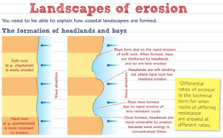
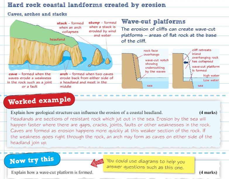
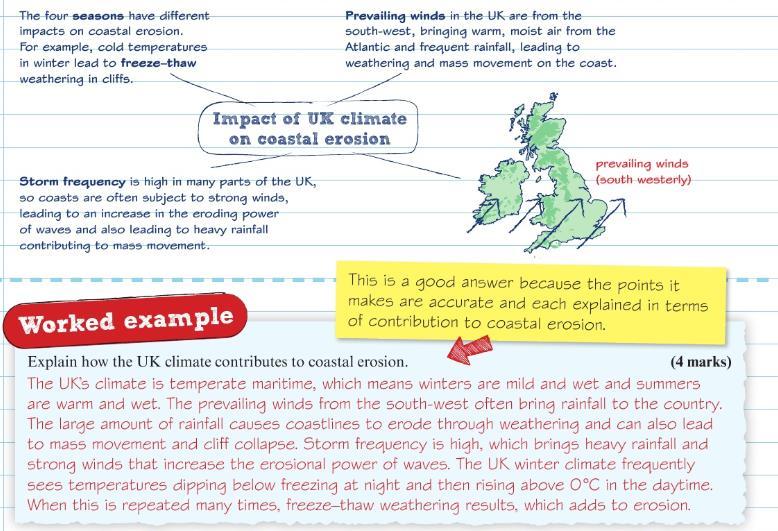
10 UK s Physical Landscape Practice Questions 1. Explain one way glacial processes have contributed to the formation of the UK s physical landscape (2 marks) 2. State the main characteristics of a sedimentary rock (1 mark) 3. Explain how metamorphic rocks form. (2 marks) 4. Explain two ways in which humans have influenced the landscape of the UK. ( 4 marks) 5. Explain how past tectonic processes have shaped the UK landscape (4 marks) 6. Explain one way that climate may be influencing the physical processes in this landscape (2 marks) Coasts Learning Checklist Learning Objective I understand how geological structure and rock type influence erosional landforms in the formation of coastal landscapes of erosion. (Hard/soft rock) (Headlands, Bays, caves, arches, cliffs, stacks) I understand how UK climate, marine and sub-aerial processes are important in coastal landscapes or erosion & rate of erosion. I understand how sediment transportation and deposition processes influence coastal landforms on coastal landscapes of deposition. I understand how human activities have direct or indirect effects on coastal landscapes.
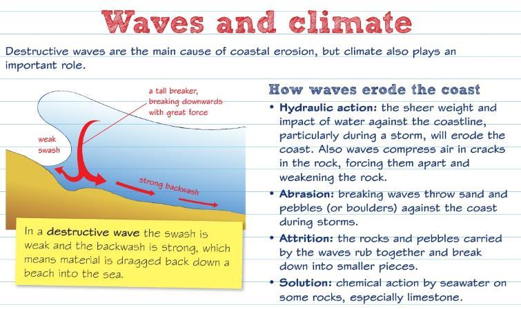
11 I understand how the interaction of physical and human processes is causing change on a named local landscape including the significance of its location. I understand why there are increasing risks from coastal flooding and the threats to people and environment I understand why there are costs and benefits to, and conflicting views about, managing coastal processes by hard/soft/sustain engineering strategies. Coasts Key Words Keywords Abrasion Arch Attrition Backwash Bar Beach Beach profile Cave Concordant Constructive waves Definition the scratching and scraping of a river bed and banks by the stones and sand in a river a curved passage through a headland created when a cave which was eventually broken through by erosion the wearing away of particles of debris by the action of other particles, such as river or beach pebbles the flow of water back to the sea after waves break on a beach an accumulation of sediment that grows across the mouth of a bay, caused by longshore drift an area of sand or pebbles along the shore of a body of water the shape of a beach resulting from how waves break a large hole, either underground or in the side of a hill or cliff, often created when waves force their way into cracks in the cliff face (coasts) follow the ridges and valleys of the land, so the rock strata is parallel to the coastline build beaches by pushing sand and pebbles further up the beach
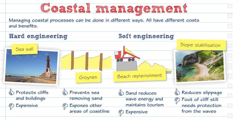
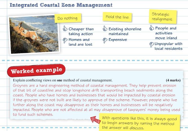
12 Cost-benefit analysis looking at all the costs of a project, social and environmental as well as economic, and deciding whether it is worth going ahead Destructive waves Discordant Fetch Groynes Hard engineering Holistic Hydraulic action Integrated Coastal Zone Management (ICZM) Marine processes Prevailing wind Recurved end Shoreline Management Plan (SMP) Soft engineering Spit Stack waves which erode beaches (coasts) alternate between bands of hard rocks and soft rocks, so the rock *strata is at right angles to the coast the length of water over which the wind has blown, affecting the size and strength of waves wooden or stone structures built at right angles to the coast to trap sediment from longshore drift, allowing a beach to build up building physical structures to deal with natural hazards, such as sea walls to stop waves (coastal management) takes into account all social, economic and environmental costs and benefits.tthis means looking at the coastline as a whole instead of an individual bay or beach the force of water along the coast, or within a stream or river the holistic management of coasts wave-related processes that contribute to coastal erosion the most frequent direction the wind blows in a certain area the hooked end of a spit an approach which builds on knowledge of the coastal environment and takes account of the wide range of public interest to avoid piecemeal attempts to protect one area at the expense of another involves adapting to natural hazards and working with nature to limit damage a ridge of sand running away from the coast, usually with a curved seaward end a tall column of rock left standing in the sea after wave erosion has separated it from the mainland


13 Storm surge Stump Suspension Swash Terminal groyne syndrome a rapid rise in the level of the sea caused by low pressure and strong winds the part of a stack that has been left after wave erosion has caused the stack to collapse tiny particles of sediment dispersed in water when water rushes up a beach when the last groyne along a coast prevents longshore drift from bringing material to other areas, causing erosion problems further down the coast Coasts Revision Material
14
15
16
17
18

19
20
21
22

23 Coasts Practice Questions
 3.")
 5.")
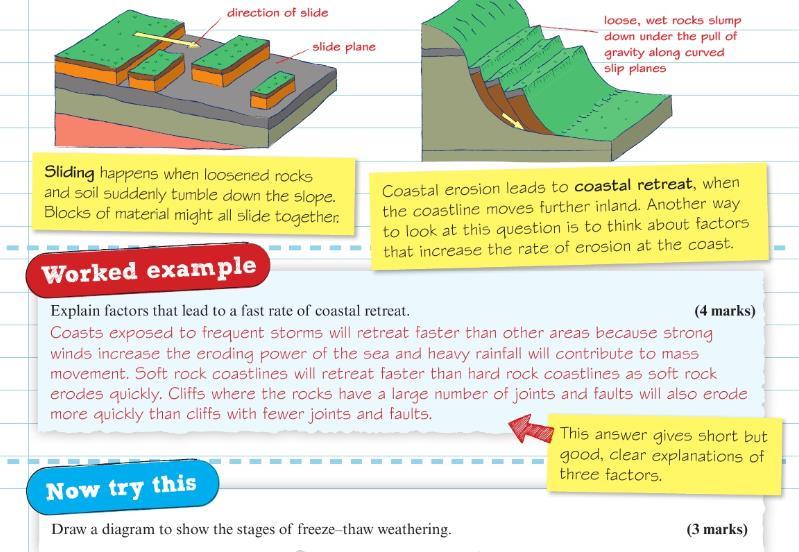
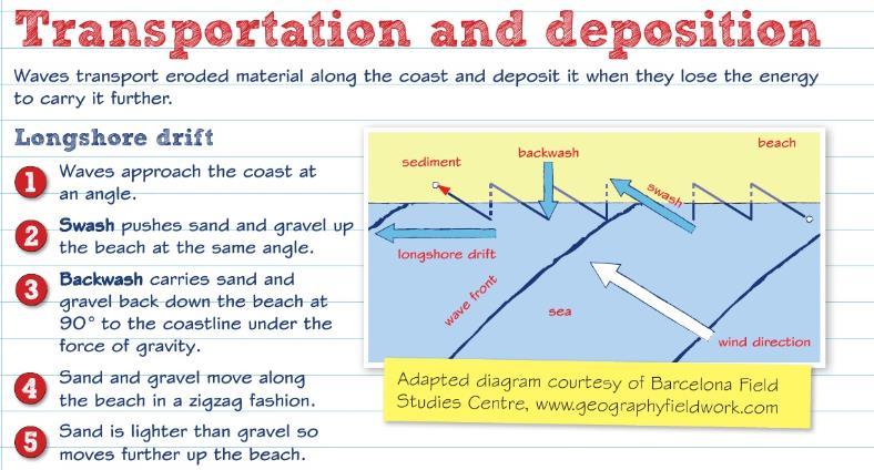
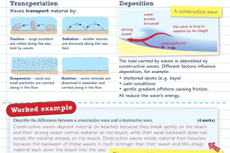
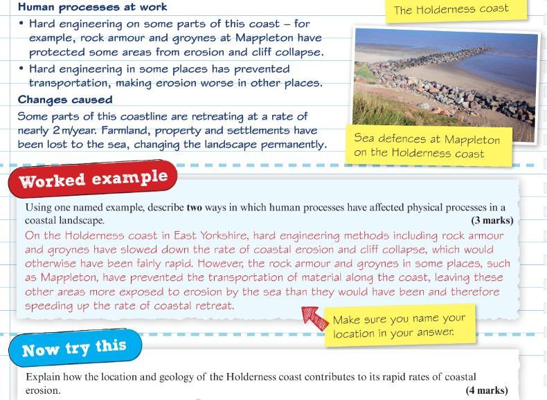
24 1. Identify two landforms that are characteristic of a discordant coast (2 marks) 2. Explain how a wave cut platform is formed (4 marks) 3. Describe two ways in which waves erode a coast (2 marks) 4. Draw a diagram to show the stages of freeze-thaw weathering (3 marks) 5. Explain the process of longshore drift (4 marks) 6. Describe how spits are formed (2 marks) 7. Explain one way in which agriculture has affected coastal landscapes (2 marks)
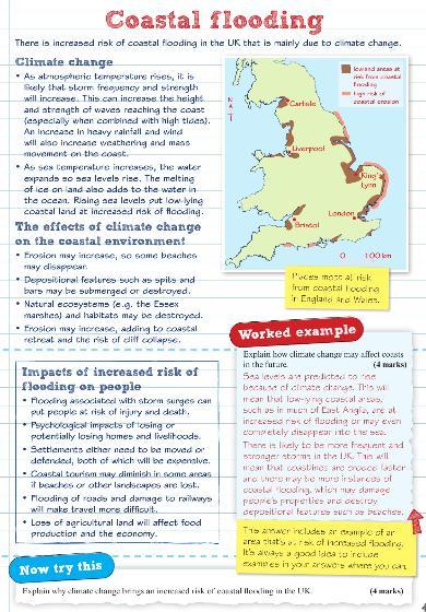
25 8. Explain why climate change brings an increased risk of coastal flooding in the UK (4 marks) 9. Outline one cost and one benefit of one hard engineering method of coastal management. (4 marks) 10. Define the term concordant coast (1 mark) 11. Describe two characteristics of soft rock cliffs (2 marks) 12. Explain two differences between destructive and constructive waves (2 marks) 13. State two factors that influence the size and type of wave (2 marks) 14. Define the term sub-aerial processes (1 marks) 15. Draw a labelled diagram to explain the process of longshore drift (3 marks) 16. Explain how human activities can affect the coastal landscape (4 marks) 17. For a named example, explain how coastal management processes have changed the coastal landscape (4 marks) 18. Explain why sea-level rise is threatening coastal areas across the UK. (4 marks) 19. Coastal areas are increasingly threatened by rising sea levels. Assess the possible consequences of sea level rise for people living near the coast (8 marks) 20. Explain how groynes can help reduce rates of coastal erosion (2 marks) 21. Describe one advantage of beach nourishment (2 marks) 22. Explain one advantage of using hard defences at the coast (2 marks)
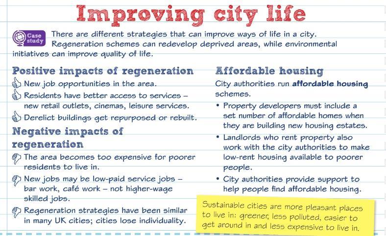
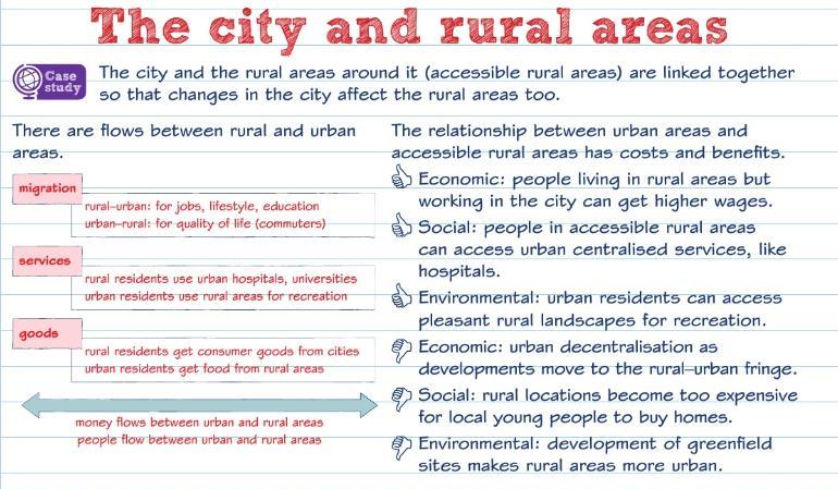
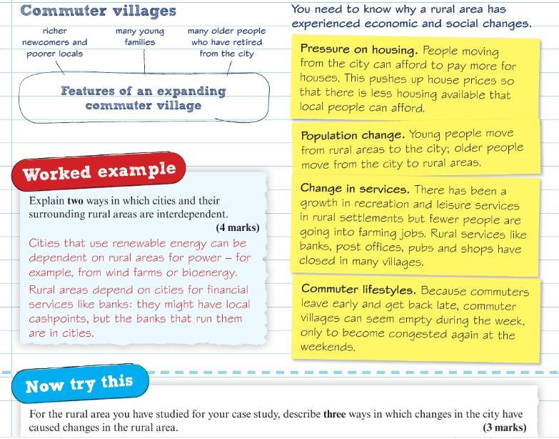
26 UK s Human Landscape Learning Checklist Learning Objective I understand the differences between urban core and rural. I know how the UK and EU government policies have attempted to reduce them. I understand why national and international migration over the past 50 years has altered the population geography of the UK, examining UK and EU immigration policy. I understand the decline in primary and secondary sectors and the rise of tertiary and quaternary sectors in urban and rural areas, altering employment structures in different UK regions. I understand why globalisation, free-trade policies and privatisation has increased foreign direct investment and the role of TNC s in the UK economy. I understand the significance of site, situation and connectivity of the city in a national, regional and global context. I understand the city s structure, inner city, in terms of its functions and variations in building age and density, land-use and environmental quality. I understand the causes of national and international migration that influence growth and character the different parts of the city. I understand the reasons for different levels of inequality, in employment and services, education, health in different parts of the city. I understand how parts of the city have experienced decline, de-centralisation, e-commerce, developments in transport. I understand how parts of the city have experiences economic and population growth. I understand how regeneration and rebranding of the city has positive and negative impacts on people.

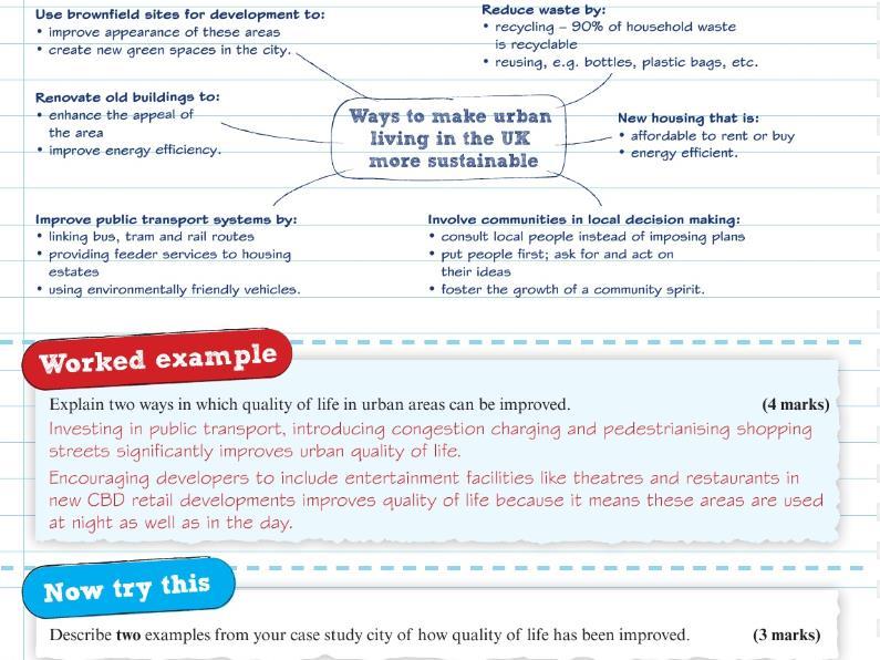
27 I understand the strategies aimed at making urban living more sustainable and improving quality of life in the city. UK s Human Landscape Key Words Keyword Definition UK s Human Landscape Revision Material
28
29
30
31
32
33
34
35
36


37 UK s Human Landscape Practice Questions
38
39
40 Geographical Investigations (Fieldwork) Learning Checklist Learning Objective Investigating coastal change and conflict I understand different questions that can be investigated through fieldwork in the coastal environment. I understand how to use one quantitative fieldwork method to measure coastal management. I understand how to use one qualitative fieldwork method to collect on data on coastal management. I understand how to use two secondary data sources. Investigating urban areas I understand different questions that can be investigated through fieldwork in the urban environments. I understand how to use one qualitative fieldwork method to collect data on perceptions of quality of life. I understand how to use one qualitative fieldwork method to collect on data on environmental quality. I understand how to secondary sources such as census data and one other method. Geographical Investigations (Fieldwork) Key Words Keyword Definition
 Revision")
41 Geographical Investigations (Fieldwork) Revision Material
42
43
44
45
46 Geographical Investigations (Fieldwork) Practice Questions
Year 11 Geography. Paper 2 UK Geographical Issues. Mock Exam Revision Booklet
 Year 11 Geography Paper 2 UK Geographical Issues Mock Exam Revision Booklet Contents Page Topic Exam Command Words How to structure your answers UK s Physical Landscape Checklist UK s Physical Landscape
I CAN DO sheets Southchurch High School
 Rate your confidence in the following topic content and geographical skills by ticking the appropriate column beside each point: Red = Not confident Yellow = Almost there Green = Confident Changing landscapes
New GCSE Geography AQA
 Learning Checklist Half Term 1 26 th September 3 rd October 10 th October 17 th October 1.1.1 Tectonic Hazards Plate tectonics theory. Global distribution of earthquakes and volcanic eruptions and their
Term Knowledge Using and applying Grade Criteria Autumn 1 Assessment window October Natural hazards pose major risks to people and property.
 Assessment Schedule Year 9 2015/6 Term Knowledge Using and applying Grade Criteria Autumn 1 Assessment window October 2015 3.1.1.2 Tectonic Natural hazards pose major risks to people and property. Definition
Geography Exams. RAG rate The Challenge of Natural Hazards
 Geography Exams You will sit three papers, Paper 1 will last 1 hour 30 minutes and will examine your understanding of The Challenge of Natural Hazards, The Living World and Physical Landscapes in the UK.
PiXL Independence: Geography Answer Booklet KS4. AQA Style, UK Physical Landscapes. Contents: Answers
 PiXL Independence: Geography Answer Booklet KS4 AQA Style, UK Physical Landscapes Contents: Answers 1 I. Multiple Choice Questions 1 Where in the UK would you describe as having large areas of uplands?
What is weathering and how does it change Earth s surface? Answer the question using
 7 th Grade Lesson What is weathering and how does it change Earth s surface? Answer the question using the sentence frame. You have 4 minutes. Weathering is. This changes the Earth s surface because. 1
Year 10 Geography Curriculum Plan. Geography Edexcel B (9-1) Investigating Geographical Issues (2016)
 Investigating Geographical Issues (2016)") Topic 1: Development Dynamics Paper 1 > Topic 2) Year 10 Geography Curriculum Plan Geography Edexcel B (9-1) Investigating Geographical Issues (2016) Key concept/ Key question Overview of the unit Assessment
Topic 1: Development Dynamics Paper 1 > Topic 2) Year 10 Geography Curriculum Plan Geography Edexcel B (9-1) Investigating Geographical Issues (2016) Key concept/ Key question Overview of the unit Assessment
Physical landscapes River landscapes in the UK
 Physical landscapes River landscapes in the UK The shape of river valleys change s as rivers flow downstream - PROCESSES Erosion Abrasion or corrasion Attrition Hydraulic Action Solution or corrosion Deposition
Marr College Geography Department. Can-Do Checklist for Higher Geography
 Marr College Geography Department Can-Do Checklist for Higher Geography The Higher Geography exam consists of one paper. It is out of a total of 60 marks. The total time for the paper is 2 hours 15 minutes.
How does erosion happen?
 How does erosion happen? By National Geographic, adapted by Newsela staff on 10.03.17 Word Count 682 Level 830L These rock formations, in Bryce Canyon National Park, Utah, are called hoodoos. Although
2018 Geography Mock Examination
 2018 Geography Mock Examination Your Geography mock examination will test your understanding of Paper 1 (Living with the physical environment) and Section B (Fieldwork) from Paper 2. Attached are the necessary
Coasts Key Word Glossary
 Coasts Key Word Glossary Abrasion Also known as corrosion. It is the wearing away of the cliff by sand, fragments of rock and boulders that are being hurled at the cliff by the waves. It causes grinding
Read Across America. Listen as I read for facts about Volcanoes. In the Shadow of the Volcano
 Read Across America Listen as I read for facts about Volcanoes. In the Shadow of the Volcano Constructive & Destructive Processes Earth s surface is always changing. Blowing wind and flowing water causes
COASTLINES MARINE EROSION PROCESSES. Read the course booklet.
 MARINE EROSION Read the course booklet. PROCESSES. You will need to know and be able to explain the four methods of coastal erosion and two of weathering The next few slides illustrate these processes.
Erosion and Deposition
 CHAPTER 3 LESSON 2 Erosion and Deposition Landforms Shaped by Water and Wind Key Concepts What are the stages of stream development? How do water erosion and deposition change Earth s surface? How do wind
EXTERNAL LAND FORMING PROCESSES
 NAME SCHOOL INDEX NUMBER DATE EXTERNAL LAND FORMING PROCESSES WEATHERING 1 1998 Q 7 (a) (i) What is the difference between weathering and mass wasting (ii) List five processes involved in chemical weathering
Geol 117 Lecture 18 Beaches & Coastlines. I. Types of Coastlines A. Definition:
 I. Types of Coastlines A. Definition: 1. Shore = narrow zone where ocean meets land (e.g. beach) 2. Coast is a broad area where both ocean and land processes act a. Includes onshore marshes, dunes, sea
Edexcel GCSE Geography A
 Edexcel GCSE Comparing the 2012 AQA GCSE specification with the new 2016 Edexcel specification This document is designed to help you compare the existing 2012 AQA GCSE specification (9030) with the new
KS3 Geography Year 8 Core Questions
 Geography Department KS3 Geography Year 8 Name: Class: Teacher: Core Questions These core questions cover key facts for each of the units you will study during year 8. It is an important revision skill
Time allowed: 1 hour 30 minutes
 SPECIMEN ASSESSMENT MATERIAL: SET 2 GCSE GEOGRAPHY Paper 1 Living with the physical environment Specimen Materials For this paper you must have: a pencil a ruler. Time allowed: 1 hour 30 minutes Instructions
Coastal Study Delimara Peninsula
 Coastal Study Delimara Peninsula Edward Gilson Fieldwork Report Coastal Study Coastal Processes Delimara Peninsula Location:. Date: Time:. Apparatus:. Weather Conditions: Objectives / Aims: Geography Option
Weathering and Erosion
 Have you ever looked at the land around you and wondered how it was shaped? The geologic features that help define the world are still being shaped by the natural processes of weathering, erosion, and
Form 7 Geography. November Exam Revision 2018
 Form 7 Geography November Exam Revision 2018 Location Knowledge You will need to be able to locate both physical and human features on a map of the UK. These are Maps 3 and Maps 4 in your Global Location
Chapter 3 Erosion and Deposition. The Big Question:
 Chapter 3 Erosion and Deposition The Big Question: 1 Design a way to represent and describe the 4 types of mass movement. You may use pictures, diagrams, list, web, chart, etc 2 Chapter 3: Erosion and
What are the different ways rocks can be weathered?
 Romano - 223 What are the different ways rocks can be weathered? Weathering - the breakdown of rocks and minerals at the Earth s surface 1. 2. PHYSICAL WEATHERING Rock is broken into smaller pieces with
Subject Area: Geography
 Long Term Planning Overview Key Stage 3 Subject Area: Geography Academic : 08-9 7 Assessment Your Island Home the physical and human geography of the UK and will investigate weather patterns, population
Geography GCSE. Year 9 Term and Topic Unit Content Homework Opportunities
 Geography GCSE Year 9 Term and Topic Unit Content Homework Opportunities Autumn Term 1: Geographical Skills Autumn Term 2: Tectonic Hazards Spring Term 1: Ecosystems Rainforest Students are required to
4. The map below shows a meandering stream. Points A, B, C, and D represent locations along the stream bottom.
 1. Sediment is deposited as a river enters a lake because the A) velocity of the river decreases B) force of gravity decreases C) volume of water increases D) slope of the river increases 2. Which diagram
Unit 1 Living with the Physical Environment
 Unit 1 Living with the Physical Environment Topic Example / Case Study Example Tectonic Hazards Chile Nepal Weather Hazards Typhoon Haiyan Somerset Floods Climate Change Ecosystems Tropical Rainforests
1 Shoreline Erosion and Deposition
 CHAPTER 12 1 Shoreline Erosion and Deposition SECTION Agents of Erosion and Deposition BEFORE YOU READ After you read this section, you should be able to answer these questions: What is a shoreline? How
The Marine Environment
 The Marine Environment SECTION 16.1 Shoreline Features In your textbook, read about erosional landforms, beaches, estuaries, longshore currents, and rip currents. For each statement below, write or. 1.
Name. 4. The diagram below shows a soil profile formed in an area of granite bedrock. Four different soil horizons, A, B, C, and D, are shown.
 Name 1. In the cross section of the hill shown below, which rock units are probably most resistant to weathering? 4. The diagram below shows a soil profile formed in an area of granite bedrock. Four different
Coastal Processes, Patterns and Associated Landforms, and Human Interaction
 Coastal Processes, Patterns and Associated Landforms, and Human Interaction Coastal processes, patterns and associated landforms Coastal processes and the impact of recreational pressures, coastal defence
OCR 2008 AS and A level Geography Specification Mapping Guide
 OCR 2008 AS and A level Geography Specification Mapping Guide Contents Introduction Error! Bookmark not defined. Specification map: 2008 OCR AS and A level Geography 3 What's new? 10 Introduction This
EROSION AND DEPOSITION
 CHAPTER 8 EROSION AND DEPOSITION SECTION 8 1 Changing Earth s Surface (pages 252-255) This section explains how sediment is carried away and deposited elsewhere to wear down and build up Earth s surface.
Global Atmospheric Circulation. Past climate change and natural causes. Global climate change and human activity
 GCSE Geography Edexcel B Revision Checklist Paper 1. Global Geographical Issues Topic 1. Hazardous Earth Key Idea I know/ understand The world s climate system Global Atmospheric Circulation Past climate
Year 11 Revision Booklet
 Year 11 Revision Booklet Paper 1: Living with the physical environment The challenge of natural hazards Question 1 The living world Question 2 Coastal landscapes in the UK Question 3 River landscapes in
GCSE Revision Booklet
 GCSE Revision Booklet Paper 1: Living with the physical environment Question 1 The challenge of natural hazards The living world Question 2 Coastal landscapes in the UK Question 3 River landscapes in the
A Level Geography Transition Pack
 Coasts (to go to Mr. Hicks) Independent Research Tasks Complete the tasks below to help you see the bigger picture of the coasts topic. 1. What effect will sea level rise have on coastlines? 2. http://www.theguardian.com/environment/sea-level
Edexcel GCSE Geography B
 Comparing the specification with the new 2016 specification This document is designed to help you compare the existing specification 2G01 with the new 2016 specification. The document gives an overview,
Coastal Systems and Landscapes 3 days
 AS Level Geography WJEC Coastal Systems and Landscapes 3 days This course is for Welsh schools. This in-depth course prepares students for the physical fieldwork focusing on the Coastal option, for Section
STAAR 2013 #20; RC3; Readiness 1. Glaciers are masses of ice that move slowly on land. Which of these features was most likely formed by a glacier?
 Earth oot amp #1 5.7 Recognize how landforms such as deltas, canyons, and sand dunes are the result of changes to Earth s surface by wind, water, and ice. STR 2013 #20; R3; Readiness 1. Glaciers are masses
1. The diagram below shows the stump of a tree whose root grew into a small crack in bedrock and split the rock apart.
 1. The diagram below shows the stump of a tree whose root grew into a small crack in bedrock and split the rock apart. 4. Which process involves either a physical or chemical breakdown of earth materials?
Weathering of Rocks. Weathering - Breakdown of rocks into pieces (sediment) 2 main types of weathering to rocks
 2 main types of weathering to rocks") Weathering of Rocks Weathering - Breakdown of rocks into pieces (sediment) 2 main types of weathering to rocks Mechanical weathering requires physical forces to break rocks into smaller pieces. Chemical
Weathering of Rocks Weathering - Breakdown of rocks into pieces (sediment) 2 main types of weathering to rocks Mechanical weathering requires physical forces to break rocks into smaller pieces. Chemical
The Coast: Beaches and Shoreline Processes Trujillo & Thurman, Chapter 10
 The Coast: es and Shoreline Processes Trujillo & Thurman, Chapter 10 Oceanography 101 Chapter Objectives Recognize the various landforms characteristic of beaches and coastal regions. Identify seasonal
The Coast: Beaches and Shoreline Processes
 1 2 3 4 5 6 7 8 9 The Coast: es and Shoreline Processes Trujillo & Thurman, Chapter 10 Oceanography 101 Chapter Objectives Recognize the various landforms characteristic of beaches and coastal regions.
Coastal Systems and Landscapes
 AQA Geography A-level Coastal Systems and Landscapes PMT Education Written by Jeevan Singh Coastal Systems and Landscapes Features of Coastal Zones Coastal zones develop from interactions between the winds,
8UNIT. External dynamics of the Earth. What do you remember? Key language. Content objectives
 8UNIT External dynamics of the Earth What do you remember? Can you name the solids in the photograph? nd the liquid? Is the liquid moving? How does it move? What is the name of this formation of water?
Weathering, Erosion, and Deposition Guided Notes
 1. Weathering, Erosion, and Deposition 2. Outline Section 1: Weathering Section 2: Erosion Section 3: Deposition Section 4: Case Study Weathering, Erosion, and Deposition Guided Notes 3. Section 1: Weathering
AS & A2 Geography for OCR. Tailored Courses. Slapton Ley
 AS & A2 Geography for OCR Tailored Courses Slapton Ley Please visit http://www.field-studies-council.org/outdoorclassroom/geography/aqa/ for alternative A-level AQA programmes OVERVIEW Since the assessment
The Marine Environment
 The Marine Environment SECTION 16.1 Shoreline Features In your textbook, read about erosional landforms, beaches, estuaries, longshore currents, and rip currents. For each statement below, write true or
Coastal Landscapes Case Study 3 days
 GCSE Geography OCR B Coastal Landscapes Case Study 3 days In-depth study of a coastal landscape providing a detailed case study, to ensure students are prepared for Paper 1: Our Natural World. Complete
Grade 5 Hands on Science Weathering, Erosion and Deposition
 Grade 5 Hands on Science Weathering, Erosion and Deposition Objective: To demonstrate and investigate the effect of weathering, water and wind erosion and the subsequent deposition into landforms. Background:
Paper One Living with the Physical Environment. SECTION C Physical Landscapes in UK
 GCSE GEOGRAPHY Revision Questions Paper One Living with the Physical Environment SECTION C Physical Landscapes in UK COASTS Note: questions get progressively more demanding as you move through. Mark schemes
1/6/ th Grade Earth s Surface. Chapter 3: Erosion and Deposition. Lesson 1 (Mass Movement)
") Lesson 1 (Mass Movement) 7 th Grade Earth s Surface Chapter 3: Erosion and Deposition Weathering the chemical and physical processes that break down rock at Earth s surface Mechanical weathering when rock
Lesson 1 (Mass Movement) 7 th Grade Earth s Surface Chapter 3: Erosion and Deposition Weathering the chemical and physical processes that break down rock at Earth s surface Mechanical weathering when rock
National 5 Geography Course content checklist
 National 5 Geography Course content checklist This checklist is designed to help you check your understanding of the course content. By ticking the relevant colour you can prioritise revision content prior
1. Erosion by Running Water Most powerful cause of erosion
 I. Destructive Forces Notes: Destructive force: a process in which land is destroyed or changed such as weathering and erosion. All landforms are a result of a combination of constructive and destructive
Key terms for Theme 1
 Key terms for Theme 1 Terms used in red font are used in the specification. It would be reasonable to expect question setters to use these terms. Other terms and their definitions have been provided by
water erosion lithosphere Describe the process of erosion and deposition. chemical weathering Dissolving limestone is an example of.
 At one time, there was one large island off the coast of Mississippi and now it is two separate islands. What caused the island to be split into two? water erosion The crust and the top part of the upper
Erosion and Deposition
 Erosion and Deposition Erosion Sediment natural forces move rock/soil from one place to another. gravity, water, wind, glaciers, waves are causes material moved by erosion Deposition when erosion lays
1. Any process that causes rock to crack or break into pieces is called physical weathering. Initial product = final product
 Weathering 1. Any process that causes rock to crack or break into pieces is called physical weathering. Initial product = final product End Result of physical weathering is increased surface area. 2. Physical
core mantle crust the center of the Earth the middle layer of the Earth made up of molten (melted) rock
 rock") core the center of the Earth mantle the middle layer of the Earth made up of molten (melted) rock crust the surface layer of the Earth that includes the continents and oceans 1 continental drift the theory
core the center of the Earth mantle the middle layer of the Earth made up of molten (melted) rock crust the surface layer of the Earth that includes the continents and oceans 1 continental drift the theory
CNCS GCSE. Case Study and Exam Question Revision Booklet
 1 CNCS GCSE Case Study and Exam Question Revision Booklet Note: there is no single way to respond to a 9 mark question attached is guidance only (Grades 7-9 will require judgement and will need to be more
Erosion and Deposition
 Erosion and Deposition The Erosion-Deposition Process What do you think? Read the two statements below and decide whether you agree or disagree with them. Place an A in the Before column if you agree with
Unit 7.2 W.E.D. & Topography Test
 Name: Score: Unit 7.2 W.E.D. & Topography Test 1. 2. 3. 4. 5. 6. 7. 8. 9. 10. 11. 12. 13. 14. 15. 16. 17. 18. 19. 20. 21. 22. 23. 24. 25. 1. The formation of mountains is due mainly to while the destruction
Coastal Landscapes Case Study 3 days
 GCSE Geography OCR A Coastal Landscapes Case Study 3 days In-depth study of a coastal landscape providing a detailed case study, to ensure students are prepared for the Paper 1 exam: Living in the UK Today.
Definition of LZ/ card sort activity on parts of the LZ/ discussion on inputs and outputs of the coastal system
 Year 12 Subject Gg Topic Coasts Week 1-6 Coverage / key questions Resources Homework Lesson Learning outcomes Teacher Student Assessment 1 Explain what the littoral zone is Describe the various parts of
Constructive and Destructive Forces. Processes That Act Upon Earth s Surface Features
 Constructive and Destructive Forces Processes That Act Upon Earth s Surface Features What are Constructive and Destructive Forces? Constructive Force A constructive force is a process that raises or builds
Pratice Surface Processes Test
 1. The cross section below shows the movement of wind-driven sand particles that strike a partly exposed basalt cobble located at the surface of a windy desert. Which cross section best represents the
Edexcel 2 Landscape systems, processes and change
 Edexcel 2 Landscape systems, processes and change Area of the Spec Field Site Research areas Primary data collection Secondary data access Statistical analysis High and low Identifying of different Local
SUBJECT : Geography Topics: Learning Outcomes:
 SUBJECT : Geography 2016-17 Yr7 What is geography and Britain? Students are introduced to the topic of geography and why it is so important to our everyday lives. Within the subject students explore the
No. of Periods. Syllabus Topics Specific Objectives Teaching Strategies. rational to live in hazard-prone areas?
 (Syllabus for F.4 Geog. September 2016 - July 2017) -1- SING YIN SECONDARY SCHOOL SYLLABUS FOR GEOGRAPHY -- SEPTEMBER 2016 - JULY 2017 FORM FOUR Textbooks : Senior Secondary Exploring Geography 1 (Second
 Page 1 of 9 Name: Base your answer to the question on the diagram below. The arrows show the direction in which sediment is being transported along the shoreline. A barrier beach has formed, creating a
Ch 10 Deposition Practice Questions
 1. Base your answer to the following question on the data table below. Six identical cylinders, A through F, were filled with equal volumes of sorted spherical particles. The data table shows the particle
Demonstrate knowledge of Earth Science. US (v5), 2 credits
, 2 credits") GEOLOGY UNIT STANDARD Demonstrate knowledge of Earth Science US 18982 (v5), 2 credits UNIT STANDARD Title: Demonstrate knowledge of Earth science Level: 1 Credits: 2 Purpose: People credited with this
GEOLOGY UNIT STANDARD Demonstrate knowledge of Earth Science US 18982 (v5), 2 credits UNIT STANDARD Title: Demonstrate knowledge of Earth science Level: 1 Credits: 2 Purpose: People credited with this
TEACHER BACKGROUND KNOWLEDGE. Surface Processes: Weathering and Erosion
 TEACHER BACKGROUND KNOWLEDGE Surface Processes: Weathering and Erosion Core Concepts Precipitation (caused by the water cycle) and wind cause rocks to be broken into smaller pieces in the process called
Geography - S8 Revision Topics for Trial in November 2013 (Oundle Scholarship)
") Geography - S8 Revision Topics for Trial in November 2013 (Oundle Scholarship) Your Trial in November 2013 will last 1 hour and 30 minutes. You will undertake Sections 1 and 2 during the allocated 1 hour
Geography - S8 Revision Topics for Trial in November 2013 (Oundle Scholarship) Your Trial in November 2013 will last 1 hour and 30 minutes. You will undertake Sections 1 and 2 during the allocated 1 hour
Changing Earth s Surface
 Name Date Class Changing Earth s Surface What processes wear down and build up Earth s surface? What causes the different types of mass movement? Erosion is the process by which natural forces move weathered
Analyzing our Topic IF SO, MAKE THE CHANGES AND BE READY TO REPORT OUT!
 Analyzing our Topic Look at the opening slide. Does anything there (words, pictures) make you want to change your thoughts from the smarties and chalk activities? IF SO, MAKE THE CHANGES AND BE READY TO
WORK THROUGH THE REVISION CHECKLISTS TO STRUCTURE YOUR REVISION AND HELP YOU TO IDENTIFY AREAS FOR IMPROVEMENT
 GCSE Geography: AQA 8035 http://www.aqa.org.uk/subjects/geography/gcse/geography-8035 Exam advice Work at one mark per minute Learn all key words Look at command words so that you understand what the question
Introduction The Exam...vii. 1. Maps and Photographs...1
 CONTENTS Introduction The Exam...vii Section 1...vii Section 2...viii 1. Maps and Photographs...1 Grid references on maps...1 Scale and measuring distance...3 Directions on maps...5 Area on maps...6 Height
4 th Grade Science Unit C: Earth Sciences Chapter 6: Minerals and Rocks Lesson 1: What are minerals?
 4 th Grade Science Unit C: Earth Sciences Chapter 6: Minerals and Rocks Lesson 1: What are minerals? mineral A mineral is a natural, nonliving, solid crystal that makes up rocks. All over the world, each
Potential short answer questions: What is Pangea? Describe at least 4 pieces of evidence that led Wegener to suggest the theory of Continental Drift.
 6th Grade Earth Science Fall Semester Mid-Term Study Guide The mid-term may include: 4 short answer questions,1-2 sketches to draw and/or label, 4 partially filled charts which you should complete, 30
Name: Period: Date: ID: A. Circle the choice that best completes the statement or answers the question and write the letter on the blank.
 Name: Period: _ Date: _ ID: A Unit 7 Practice Circle the choice that best completes the statement or answers the question and write the letter on the blank. 1. What term describes the movement of rock
Weathering, Erosion, Deposition
 Weathering, Erosion, Deposition The breakdown of rocks at or near the Earth s Surface. Physical Chemical - The breakdown of rock into smaller pieces without chemical change. - Dominant in moist /cold conditions
GCSE Geography Paper 1 Practice Paper
 GCSE Geography Paper 1 Practice Paper Student Name: Academy: GCSE Geography Paper 1 Living with the physical environment Assessment Objectives: A01 = 21% is about knowledge A02 = 31% is about understanding
Weathering, Erosion, Deposition, and Landscape Development
 Weathering, Erosion, Deposition, and Landscape Development I. Weathering - the breakdown of rocks into smaller particles, also called sediments, by natural processes. Weathering is further divided into
THE CHANGING SURFACE OF THE EARTH
 THE CHANGING SURFACE OF THE EARTH Key words Drain geological agent weathering erosion Sediment deposition transport The landscape is a consequence of the action of two types of geological processes; internal
1. The coastal system. Constructive and destructive waves, Tides Sediment sources and cells.
 Features of the Coastal System INPUTS PROCESSES OUTPUTS Sediment 95% = 5% = 5% = 1. The coastal system Constructive and destructive waves, Tides Sediment sources and cells. The Coastal System Identify
Science EOG Review: Landforms
 Mathematician Science EOG Review: Landforms Vocabulary Definition Term canyon deep, large, V- shaped valley formed by a river over millions of years of erosion; sometimes called gorges (example: Linville
Curriculum Content Summary
 Curriculum Content Summary SUBJECT: Geography Term One Term Two Year 7 Year 8 Year 9 Year 10 Year 11 Year 12 Year 13 Rivers and river floods Glaciers Environmental Issues Controlled Crowded Coasts [opportunity
Topic 6: Weathering, Erosion and Erosional-Deposition Systems (workbook p ) Workbook Chapter 4, 5 WEATHERING
 Workbook Chapter 4, 5 WEATHERING") Topic 6: Weathering, Erosion and Erosional-Deposition Systems (workbook p. 95-125) Workbook Chapter 4, 5 THE BIG PICTURE: Weathering, erosion and deposition are processes that cause changes to rock material
Topic 6: Weathering, Erosion and Erosional-Deposition Systems (workbook p. 95-125) Workbook Chapter 4, 5 THE BIG PICTURE: Weathering, erosion and deposition are processes that cause changes to rock material
Name Class Date. Study Guide for 7 th Grade Final Exam (Semester One)
") Name Class Date Study Guide for 7 th Grade Final Exam (Semester One) 1. What are the steps of the scientific method? Define the problem or question Form a hypothesis (MUST BE TESTABLE) o (identify variables)
Name Class Date Study Guide for 7 th Grade Final Exam (Semester One) 1. What are the steps of the scientific method? Define the problem or question Form a hypothesis (MUST BE TESTABLE) o (identify variables)
Chapter 2 Planet Earth
 Chapter 2 Planet Earth Section Notes Earth and the Sun s Energy Water on Earth The Land Close-up The Water Cycle World Almanac Major Eruptions in the Ring of Fire Quick Facts Chapter 2 Visual Summary Video
THE SCIENCE OF MAPS. ATL Skill: Critical thinking - Use models and simulations to explore complex systems and issues
 THE SCIENCE OF MAPS 8.9C interpret topographic maps and satellite views to identify land and erosional features and predict how these features may be reshaped by weathering ATL Skill: Critical thinking
UK s Evolving Physical Landscape
 Paper 1 Global Issues Paper 2 UK Issues Paper 3 - Making Geographical Decisions Have you ever wondered 1. How does the world s climate system work and why is climate change becoming such a hazard? 2. What
Year 8 Practice Questions for Summative Assessment. NAME:...
 Year 8 Practice Questions for Summative Assessment. NAME:... Earthquakes and Volcanoes 1. (a) The diagram below shows a simple cross section of the Earth. Complete the labels. (b) Name an earthquake you
iv vi x Using maps 2 Using images and analysing data 6 Using new technologies in geography 8
 Contents Exam board specification map Introduction Topic checker iv vi x Geographical skills Using maps 2 Using images and analysing data 6 Using new technologies in geography 8 Natural hazards Tectonic
Supplemental Slides. Shore: Junction of Land & Water. Junction of Land & Water. Sea Level Variations. Shore vs. Coast. Sea Level Variations
 Shore: Junction of Land & Water Supplemental Slides Sediments come off land Most get dumped at the beach Sediment interacts with ocean waves and currents Junction of Land & Water Features: Breaking waves,