TERM PAPER OUTLINES ARE DUE ON THURSDAY 10/20 BRING TWO HARD COPIES TO CLASS
|
|
|
- Bruce Ramsey
- 6 years ago
- Views:
Transcription
1 TERM PAPER OUTLINES ARE DUE ON THURSDAY 10/20 BRING TWO HARD COPIES TO CLASS
2 Hand in hard copy Q-13 answers at beginning of class 10/25 for <10-pt extra credit The Mike Robe Gang SO H + + 6e - --> S 0 + 4H 2 O NO H + + 6e - --> 0.5N 2 + 3H 2 O -0.20V +0.75V hints Balance the half reactions with respect to mass, then charge, using e -, H +, H 2 O, or OH - Combine half reactions so electron gain equals loss Check for atom & charge balance E 0 = E 0 cathode E0 anode How does this relate to driving force for any reaction defined by ΔG r?? ΔG r = - nie

3 River transport and chemistry (Schlesinger & Bernhardt: Chapter 8) Student Learning Outcomes: Relate surrounding terrestrial systems to biogeochemical reactions that dominate stream ecosystems Recognize indicators of net heterotrophy vs. autotrophy w.r.t. streams, and along stream transport pathways
4 Soil Hydraulics & Stream Hydrology (Water flow through soils) Rivers result from the runoff of water from the continents River water ultimately comes from precipitation: Can either be evaporated from the land Can pass to shallow depths in the soil (surface flow) Can pass to greater depths and remain in the ground much longer (groundwater) Magnitude of stream water flow is controlled by: - vegetation - soil characteristics
 Runoff is low when rainfall is low. Runoff increases as rainfall increases.")
5 Runoff from high- and low-grassland plots as a function of rainfall (Fig. 8.1, 2 nd ed.) Runoff is low when rainfall is low. Runoff increases as rainfall increases. Runoff decreases as vegetation cover increases.
6 Effect of Vegetation on Holding Capacity of Soil Vegetation reduces runoff: Lowers initial impact energy of raindrops, reducing soil erosion and allowing greater time for soil infiltration Plant roots, earthworms, other soil organisms promote downward percolation of moisture through soil pores Increases surface roughness, slowing the runoff rate relative to bare soils Vegetation may reduce average soil moisture content: - plant root uptake of soil - when vegetation is removed, soil water content and runoff increase
7 Plant transpiration reduces soil moisture and runoff (% of growing season precipitation) (condensed from Table 8.1, 2 nd ed.) VEGETATION % Evaporation % Transpiration % Runoff, Recharge Tropical Rainforest Temperate Forest Temperate Grassland Steppe Desert Runoff from wet forests can be substantial. Dry systems (steppe, desert) have little to no runoff. Transpiration (biotically induced water loss) typically exceeds evaporation (meteorological water loss).
8 Stream Hydrographs: relate stream flow to time. Base flow declines slowly as drought continues. With precipitation, stream flow may increase immediately due to surface runoff. After the storm, surface runoff disappears, but soil moisture content has increased, increasing the amount available for drainage. Stream hydrograph shows the fraction of flow derived from surface runoff vs. drainage of soil water. Surface runoff may carry organic debris and soil particles. In tropical rainforests, base flow can be 92% of total flow; in deserts storm flow dominates, rivers are turbid.
9 Stream Load River water can be thought of as being made up of a number of components Water Dissolved material (total dissolved solids (TDS), major species: HCO 3-, Ca 2+, SO 4 2-, Cl -, Na +, Mg 2+, K + ) Particulate matter (major elements include: Al, Fe, Si, Ca, K, Mg, Na, P) TDS is largely derived from rainfall and from soil solution after it has interacted with soil particles (exchange reactions) and bedrock (chemical weathering) Particulate matter derives from mechanical weathering, and represents erosion and transport from soil surface. Includes suspended load and bed load Includes material ranging from colloidal clays to boulders, leaves to logs
10 Suspended flux is function of flow rate results in ~400 x increase in transport: A 10 x increase in flow rate
11 Nutrient and carbon sources Allochthonous POC and DOC > autochthonous in smaller streams In contrast, autochthonous sources > in larger, more slowly moving rivers Production of OM that is more labile than terrestrial OM Labile OM can fuel complex food webs Respired DOC and POC lost to atmosphere as CO 2 Ratio of DOC:POC increases in large rivers; they have a smaller edge effect, and DOC, CPOM is degraded in-river DOC and POC usually increase with stream flow, due to greater contribution of surface flow The river continuum concept: ecosystem productivity increases with stream size. In general: Narrow, shaded headwaters, terrestrial OM inputs dominate, R>P As channels widen, benthic algae and macrophytes increase Larger rivers, allocthonous OM dominates (again) as waters are too fast & turbid to support primary producers.
12 Sources of major elements Nearly all Ca, Mg, K is derived from rock weathering Carbonate weathering is dominant source of Ca; silicates dominate Mg & K Na, Cl, SO 4 is derived mainly from marine aerosols (Chap. 3) Na > Cl due to weathering of Na-minerals Individual streams may vary from global averages, depending upon local conditions and terranes -> geololgy exerts a strong influence (carbonates, evaporites, etc.) Anthropogenic activity has increased NO 3 and SO 4. 2/3 of bicarbonate in rivers is derived from atmosphere -> carbonic acid weathering
13 River composition as a function of water origin (Gibbs 1970). Arid-climate (evaporative) rivers have even higher concentrations and are back to Cl dominance, bicarbonate is lost to mineral precipitation. As weathering becomes important, proportion Cl goes down, TDS concentration goes up, bicarbonate dominates Cl. River runoff dominated by precipitation is proportionally high in Cl (recycled salt) and low in total concentration.
14 Estuarine Environments (Schlesinger & Bernhardt: Chapter 8) Student Learning Outcomes: Recognize the importance of estuarine environments Give examples of various coastal margin types Classify estuaries by geomorphology, circulation, and mixing processes Describe dominant estuarine processes affecting turbidity, chl a, stratification
15 Today s Outline Definitions & types of estuaries Estuarine circulation Mixing processes The mid-estuary turbidity maximum
16 The Coastal Zone - Coastal Ocean extends from the high-tide line to the shelf break This region is responsible for nearly 30% of the total net oceanic primary production and nearly 90% of the global fish catch Estuaries " Estuary is derived from the Latin word for tide - aestus Aestuarium low ground covered by the sea at high water " Estuaries and lagoons comprise 80-90% of coastline along Atlantic & Gulf Coast and 10-20% on Pacific Coast " Nearly 900 individual estuaries in the continental US " Atlantic & Gulf Coasts - border broad continental shelf - have extensive marshes - older " Pacific Coast - formed by tectonic activity, deep, narrow shelf, salt marshes small or absent - younger
17 Definitions of Estuary Two major components involved: Transition from fresh (river) water to saline (ocean) water Tidal influence One definition: An estuary is a semi-enclosed coastal water body that extends to the effective limit of tidal influence, within which sea water is significantly diluted with freshwater from land drainage
18 Why are features covering such a small portion of the ocean of high primary production importance? fishing, shipping, recreation, aquaculture, etc. most materials entering the ocean from land do so through estuaries population centers most human perturbation of the ocean (pollution, over-exploitation, dredging, etc.) occurs in estuaries
 - estuaries are ecotones between freshwater and marine habitats From Pinet")
19 Transition zones (ecotones) occur between two or more diverse communities or habitats. Species that have highest abundance in ecotones are called edge species Odum (1971) - estuaries are ecotones between freshwater and marine habitats From Pinet 2003 Estuaries can be conceptualized as physical and biological mixing zones
 Estuaries are very efficient traps for nutrients, sediments, and pollutants -")

20 The shallow and intertidal areas are usually bordered by salt marsh or mangrove vegetation (in the tropics) Estuaries are very efficient traps for nutrients, sediments, and pollutants - Usually present in high concentrations High socio-economic & ecological relevance
21 Salt marshes: geomorphology & hydrology Salt marsh vegetation exists in dynamic equilibrium between rate of sediment accumulation and rate of coastal subsidence, or sea level rise. - as deposits accumulate, erosion and OM oxidation increase, slowing rate of further accumulation - as sea level rises, marsh is inundated more frequently, and accumulation rate of sediment and peat increases. - When rate of sedimentation does not kept up with subsidence, marshland is lost. - Sea level rise due to global warming could accelerate loss of marshland.
22 Salt marshes: geomorphology & hydrology (cont d.) Salt marsh soils undergo daily cycle of changing aeration and, thus, redox state. - high tide: soils are inundated, anaerobic conditions may develop - low tide: soils drain, high redox potential re-established in surface layers Tide-induced flushing, combined with groundwater flow from land, leads to large amounts of import(export) from(to) tidal creeks. - low tide: low salinity due to flushing of marsh by freshwater runoff from land - high tide: marsh is inundated with seawater, highest salinities observed
 Isostatic sinking occurs as sediment accumulates on the shelf and sediment layer thickens (GOM) From Pinet 2003")
23 Continental Margins Passive (Atlantic-type) Margins Atlantic coast and shelf is subsiding because it is a passive margin The lithospheric plate cools and thickens with age and distance from the spreading center and sinks (subsides) Isostatic sinking occurs as sediment accumulates on the shelf and sediment layer thickens (GOM) From Pinet 2003

24 Active (Pacific-type) Margins Tectonic activity occurs along the margin The lithospheric plate is subducted beneath the continental plate Crust is pushed upward to produce an emergent coast Active continental margins usually have narrow shelves...passive margins have wide shelves From Pinet 2003

25 Shelf Sediments Sediment grain size decreases as you go further offshore due to wave energy and currents From Pinet 2003


26 Shelf Sediments Sediment grain size and feeding strategies From Pinet 2003
27 Major Factors that Determine Processes on Shelves Presence or absence of large rivers Presence or absence of upwelling Location of ocean boundaries Shelf width All of these factors are influenced by climate, hurricanes, El Niño, La Niña, global weather patterns

28 2005 Hurricane Season
 Formed by sea level rise")

29 Based on Geomorphology Drowned River Valleys or Coastal Plain estuaries (most common) Formed by sea level rise during the Holocene tide and river dominated Examples: Chesapeake Bay, Delaware Bay, Charleston Harbor From: Pinet 2003


30 Coastal Plain, Bar-Built Estuaries longshore currents form a sand bar or sand spit across an embayment Lack a major river source These estuaries are usually shallow (<2 m) and wind-dominated Example: Galveston Bay, Albemarle-Pamlico Sound From: Pinet 2003
 sill may")

31 Fjord-Type Estuaries deep (>100 m), built by glaciers, shallow sill (terminal moraine) sill may trap bottom water that may be anoxic Examples: Puget Sound, coasts of Norway and British Columbia From: Pinet 2003


32 Tectonically-Produced Estuaries formed by earthquakes and block faulting common on active coasts creates basins that become filled with water Examples: San Francisco Bay, Tomales Bay From: Pinet 2003
 Ria Coastal Plain Bar-built Blind Delta front")
33 Based on Physiography Fairbridge Classification (1980) 7 Categories based on relative relief and degree of blocking at the mouth of the estuary Fjord (fjärd) Ria Coastal Plain Bar-built Blind Delta front Tectonic
34 Based on Circulation and Hydrography Water circulation and stratification influence chemistry and biology For most estuaries, NET flow is OUT at the surface and IN along the bottom Two-layered circulation Longitudinal, lateral, and vertical circulation patterns are important


35 Estuarine Classification Based on Circulation Type A - Highly stratified, salt wedge estuary - river discharge dominates over tidal action Salt exchange by vertical advection across the fw/sw interface (halocline). Example: Mississippi River From Garrison 2002 From Sverdrup et al 2004


36 Estuarine Classification Based on Circulation From: Pinet 2003


37 Estuarine Classification Based on Circulation Type B - Partially mixed, moderately stratified - tidal flow increases relative to river discharge Vertical advection and turbulence mix the system Example: Chesapeake Bay From Garrison 2002 From Sverdrup et al 2004


38 Estuarine Classification Based on Circulation From: Pinet 2003


39 Estuarine Classification Based on Circulation Type C - Vertically homogeneous and well-mixed Intense tidal flow and strong turbulent mixing, lateral heterogeneity sometimes caused by strong winds e.g., Delaware Bay From Garrison 2002 From Sverdrup et al 2004


40 Estuarine Classification Based on Circulation From: Pinet 2003 Directed to the right, looking downcurrent, in the No Hemisphere


41 Estuarine Classification Based on Circulation Type D - Fjord - sill results in stagnant bottom waters Usually highly-stratified From Garrison 2002 From Sverdrup et al 2004


42 Estuarine Classification Based on Circulation From: Pinet 2003
43 ESTUARINE CLASSIFICATION SUMMARY Many ways to classify an estuary Geomorphology Physiography Circulation and Hydrography Salinity and Tidal Characteristics Sedimentation Ecosystem Energetics Estuaries are dynamic in space and time, highly influenced by meteorology (precipitation, hurricanes, El Niño, etc.) Are a continuum - come in a variety of sizes and shapes What are the implications for systems ecology and ecosystem processes?

44 Major Types of Circulation 1. Gravitational Circulation Induced by density and elevation differences between freshwater runoff and salt water Is responsible for classical 2-layer circulation The direction of pycnocline tilt relative to the vertical is the direction of flow Equipotential Surface - surface along which net flow is zero Usually due to salinity differences but may be temperature driven in shallow lagoons Coriolis Effect - higher salinities on NE side of large estuaries
45 MIXING PROCESSES
46 Mixing Processes Estuaries are mixing zones where freshwater is combined with saltwater Mixing - the process whereby a water parcel or water mass is diluted by, or redistributed within, other water masses (Kjerfve 1989) Sloshing - time-averaged flux of particles by oscillatory tidal currents - is a dominant longitudinal mixing process. Shear Effect - mixing over a tidal cycle due to systematic covariations of velocity and particle concentrations Shear results from different velocities of parallel currents Also known as Shear-Induced Mixing
 motions - molecular diffusion usually much less")
 diffusion, or tidal")
47 Mixing Processes Advection the water mass remains intact, but is transported Diffusion - random scattering of water parcels or particles by either random molecular or eddy (turbulent) motions - molecular diffusion usually much less than eddy diffusion Important at the sediment/water interface Dispersive Mixing - the scattering of water parcels or particles dissolved in the estuary due to tidal sloshing, shear effects, eddy (turbulent) diffusion, or tidal trapping

 Are different from Langmuir circulation cells - which are driven by")
48 Estuarine Fronts Boundary between two dissimilar water masses. Commonly form at freshwater/ saltwater interface of estuaries and plumes Surface convergence and advection downward - accumulate particulates at the surface (flotsam & foam lines) Are different from Langmuir circulation cells - which are driven by friction between wind and water surface
49 River-water and Sea-water Concentrations rw << sw Nutrients are different! rw sw
50 River-water / Sea-water Ion Ratios Two major factors: Na + /K + difference reflects lower affinity of marine rocks for sodium, as compared to potassium (ocean is a less effective sink for sodium) Ca 2+ /Mg 2+ difference reflects preferential removal of calcium in the ocean as biogenic calcite (ocean is a is more effective sink for calcium)
 If concentration vs.")
51 Salinity is a conservative constituent in estuaries and is a good indicator of mixing Mixing Curve Non-conservative mixing (source) Constituent plotted against salinity to determine if distribution is attributable to mixing processes (as opposed to non-conservative processes; nutrient uptake, flocculation, biodegradation, etc.) If concentration vs. salinity is LINEAR, then the chemical/particle exhibits conservative behavior If plot of concentration vs. salinity is NOT LINEAR, then the chemical/particle exhibits NONconservative behavior Non-conservative mixing (sink) Assumes end-members are constant over the flushing time of the estuary


")
52 Mixing Diagram Examples (from Day et al. 1989)
53 Salt Marshes as Filters & Transformers of Nutrients Salt marshes receive NO 3 from rivers and groundwaters, and convert it to DON, PON, and NH 4. Despite long-term storage of OM, salt marshes are a source of N and P to estuaries
54 Nitrogen Cycling in Salt Marshes Flooded, anaerobic sediments of salt marshes allow significant rates of denitrification. In most salt marshes, NH 4 is the dominant N-form, since nitrification rates are low, and denitrifiers remove much of the NO 3. Contribution of new inputs and recycled N in salt marshes are about equal; different from upland ecosystems where new inputs are much lower ( 10%). Salt marshes are often N-limited. N-fixation by cyanobacteria and soil bacteria may contribute significantly to the salt marsh N-budget.

55 Adsorption and Flocculation
 and organic-s.")
56 Sulfur Cycling in Salt Marshes Salt marsh sediments have high SO 4 reduction rates, due to high OM, high seawater SO 4, and frequent anaerobic conditions. Over 50% of the CO 2 respired may be due SO 4 -reduction. SO 4 -reduction produces H 2 S, which can then be transformed to pyrite (FeS 2 ) and organic-s. Permanent burial of sulfide minerals and dissolved sulfate in marsh sediment. Alternatively, H 2 S can diffuse upward out of the anaerobic zone and be re-oxidized, so that net < gross SO 4 - reduction.
57
58 The Mid-estuary Turbidity Maximum Expected: Turbidity max is due to both 1) chemical flocculation and 2) sediment resuspension Measured:

59 A Mid-estuary Trap for Riverborne Material S E A
60 Particle Distribution vs. Estuary Type Note tidal asymmetries
61 Effects Of The Mid-estuary Particle Maximum 1. Scavenging of surface-active materials % of riverine Fe is removed (most at low salinity) 60-80% of humic acids are removed 5% of total DOM is removed 2. Increased turbidity Lower primary production Reduction of photochemical reaction rates 3. Enhanced transport rates downstream / offshore Enhanced sedimentation rates downstream / offshore

62 Estuarine Plumes on the Continental Shelf cacique.uprm.edu/gers/anasco_plume.jpg

63 Estuarine Plumes on the Continental Shelf gulfsci.usgs.gov/.../ofrshelf/images/seawifs.jpg

64 Estuarine Plumes on the Continental Shelf
65 Water moving down the estuary at velocity u is in geostrophic balance The sides of the estuary counteract the Coriolis force but the water surface is tilted to balance the pressure gradient Estuarine Plumes on the Continental Shelf The Coriolis force balances the pressure gradient In the open ocean, the flow is NOT in geostrophic balance Once the buoyant plume flows out onto the shelf, the surface slope is missing and cannot provide pressure to balance the Coriolis force In the northern hemisphere, the Coriolis force causes the flow to turn to the right and flow along the coast As the Coriolis force pushes water to the right, the blocking coastline causes an opposing pressure gradient in the form of a slight slope in sea level The plume of buoyant water continues as a coastal current in geostrophic balance parallel to the coast From: Mann & Lazier 2006
66 Estuarine Plumes on the Continental Shelf Surface Slope Across an Estuary (the pressure gradient balancing Coriolis) dh = fuw / g dh = height difference from one side of the estuary to the other u = flow rate = 0.50 m s -1 W = width of estuary = 200 m f = Coriolis parameter 10-4 s -1 (at 45º N) g = acceleration due to gravity = 10 m s -2 dh = ((10-4 )(0.50)(200))/10 = m Thus, the change in height of the water surface across the estuary is 1 mm

67 An Estuarine Summary
Subtidal permanently flooded with tidal water. Irregularly exposed surface exposed by tides less often than daily
 Types of Wetlands Tidal Systems COASTAL WETLAND ECOSYSTEMS Tidal Salt Marshes Tidal Freshwater Marshes Mangrove Wetlands Tidal Estuarine Wetland 1 Definition and Formation of Estuaries u Estuary : partially
Types of Wetlands. Tidal Systems
 Types of Wetlands Tidal Systems 1 COASTAL WETLAND ECOSYSTEMS Tidal Salt Marshes Tidal Freshwater Marshes Mangrove Wetlands 2 Tidal Estuarine Wetland 3 Definition and Formation of Estuaries Estuary: : partially
Coastal Oceanography. Coastal Oceanography. Coastal Waters
 Coastal Oceanography Coastal Oceanography 95% of ocean life is in coastal waters (320 km from shore) Estuaries and wetlands are among most productive ecosystems on Earth Major shipping routes, oil and
Where is all the water?
 Where is all the water? The distribution of water at the Earth's surface % of total Oceans 97.25 Ice caps and glaciers 2.05 Groundwater 0.68 Lakes 0.01 Soils 0.005 Atmosphere (as vapour) 0.001 Rivers 0.0001
1. Introduction 2. Ocean circulation a) Temperature, salinity, density b) Thermohaline circulation c) Wind-driven surface currents d) Circulation and
 Temperature, salinity, density b) Thermohaline circulation c) Wind-driven surface currents d) Circulation and") 1. Introduction 2. Ocean circulation a) Temperature, salinity, density b) Thermohaline circulation c) Wind-driven surface currents d) Circulation and climate change e) Oceanic water residence times 3.
1. Introduction 2. Ocean circulation a) Temperature, salinity, density b) Thermohaline circulation c) Wind-driven surface currents d) Circulation and climate change e) Oceanic water residence times 3.
Wetland & Estuarine Formation & Development NREM 665
 Wetland & Estuarine Formation & Development NREM 665 1 I. Wetland Formation & Development A. Favorable climate (PPT > ET), temperature 1. don t get WTLs in B. Favorable geol/substrate 1. high H 2 O holding
Reading Material. See class website. Sediments, from Oceanography M.G. Gross, Prentice-Hall
 Reading Material See class website Sediments, from Oceanography M.G. Gross, Prentice-Hall Materials filling ocean basins Dissolved chemicals especially from rivers and mid-ocean ridges (volcanic eruptions)
Section 2.1 Ocean Basins. - Has helped determine where ocean basins are located. - Tectonic plates move changing the position of the continents.
 Science 8 Unit 1: Water Systems on Earth Chapter 2: Oceans Control the Water Cycle Section 2.1 Ocean Basins Oceans are important because: 1. Primary water source for the water cycle 2. Control weather
The surface of the ocean floor is as varied as the land. The five major oceans, from largest to smallest, are
 11.1 Ocean Basins The surface of the ocean floor is as varied as the land. The five major oceans, from largest to smallest, are w the Pacific w the Atlantic w the Indian w the Southern w the Arctic The
3.3 Classification Diagrams Estuarine Zone Coastal Lagoons References Physical Properties and Experiments in
 Contents 1 Introduction to Estuary Studies... 1 1.1 Why to Study Estuaries?.... 1 1.2 Origin and Geological Age... 4 1.3 Definition and Terminology... 7 1.4 Policy and Actions to Estuary Preservation....
Question: What is the primary reason for the great abundance of fish along the Peruvian coast?
 Buzzer Question # 1 Question Type: toss-up Question Format: Multiple Choice Category: Biology What is the primary reason for the great abundance of fish along the Peruvian coast? Answer W: upwelling Answer
Definition and classification of estuaries
 1 Definition and classification of estuaries arnoldo valle-levinson University of Florida This chapter discusses definitions and classification of estuaries. It presents both the classical and more flexible
Chapter 2. Wearing Down Landforms: Rivers and Ice. Physical Weathering
 Chapter 2 Wearing Down Landforms: Rivers and Ice Physical Weathering Weathering vs. Erosion Weathering is the breakdown of rock and minerals. Erosion is a two fold process that starts with 1) breakdown
Ocean facts continued
 Ocean Facts A dynamic system in which many chemical and physical changes take place Formed over millions of years as precipitation filled low areas on Earth called basins and now covers 70% of the Earth
Foundations of Earth Science, 6e Lutgens, Tarbuck, & Tasa
 Foundations of Earth Science, 6e Lutgens, Tarbuck, & Tasa Oceans: The Last Frontier Foundations, 6e - Chapter 9 Stan Hatfield Southwestern Illinois College The vast world ocean Earth is often referred
Module 3. Basic Ecological Principles
 Module 3. Basic Ecological Principles Ecosystem Components Abiotic Biotic Species & Habitat The Biomes of North America Communities Energy & Matter Cycles in Ecosystems Primary Productivity Simple Ecosystem
ES 105 Surface Processes I. Hydrologic cycle A. Distribution % in oceans 2. >3% surface water a. +99% surface water in glaciers b.
 ES 105 Surface Processes I. Hydrologic cycle A. Distribution 1. +97% in oceans 2. >3% surface water a. +99% surface water in glaciers b. >1/3% liquid, fresh water in streams and lakes~1/10,000 of water
BIOGEOCHEMICAL CYCLES
 BIOGEOCHEMICAL CYCLES BASICS Biogeochemical Cycle: The complete path a chemical takes through the four major components, or reservoirs, of Earth s system (atmosphere, lithosphere, hydrosphere and biosphere)
Lecture 26: Marine Geology Read: Chapter 21 Homework due December 3
 Learning Objectives (LO) Lecture 26: Marine Geology Read: Chapter 21 Homework due December 3 What we ll learn today:! 1. Describe the world s five oceans! 2. Understand patterns of ocean circulation! 3.
Biogeochemical cycles
 Lecture -2: Biogeochemical cycles ENV 107: Introduction to Environmental Science Dr. A.K.M. Saiful Islam Case Study: Lake Washington The city of Seattle, USA lies between two major bodies of water- saltwater
1. Definition and classification of estuaries Arnoldo Valle-Levinson, University of Florida
 1. Definition and classification of estuaries Arnoldo Valle-Levinson, University of Florida This chapter discusses definitions and classification of estuaries. It presents both the classical and more flexible
Weather & Ocean Currents
 Weather & Ocean Currents Earth is heated unevenly Causes: Earth is round Earth is tilted on an axis Earth s orbit is eliptical Effects: Convection = vertical circular currents caused by temperature differences
Supplemental Slides. Shore: Junction of Land & Water. Junction of Land & Water. Sea Level Variations. Shore vs. Coast. Sea Level Variations
 Shore: Junction of Land & Water Supplemental Slides Sediments come off land Most get dumped at the beach Sediment interacts with ocean waves and currents Junction of Land & Water Features: Breaking waves,
Shore: Junction of Land & Water. Sediments come off land Most get dumped at the beach Sediment interacts with ocean waves and currents
 Shore: Junction of Land & Water Supplemental Slides Sediments come off land Most get dumped at the beach Sediment interacts with ocean waves and currents Junction of Land & Water Features: Breaking waves,
9 th INTECOL Orlando, Florida June 7, 2012
 Restoration of the Everglades Saline Wetlands and Florida Bay: Responses Driven from Land and Sea David Rudnick 1, Colin Saunders 2, Carlos Coronado 2, Fred Sklar 2 Erik Stabenau 1, Vic Engel 1, Rene Price
Grade 8 Science. Unit 1: Water Systems on Earth Chapter 2
 Grade 8 Science Unit 1: Water Systems on Earth Chapter 2 Oceans are important... 1. Primary water source for the water cycle 2. Control weather 3. Support diverse life 4. Provides humans with food, minerals,
 12 10 8 6 4 2 0 40-50 50-60 60-70 70-80 80-90 90-100 Fresh Water What we will cover The Hydrologic Cycle River systems Floods Groundwater Caves and Karst Topography Hot springs Distribution of water in
Main issues of Deltas
 Global sediment supply to coastal seas and oceans; location of major river deltas RIVER DELTAS Depositional processes - Course Coastal Morphodynamics GEO3-436; lecture 4 Nile Delta, Egypt Solo Delta, Java,
The Coast: Beaches and Shoreline Processes
 1 2 3 4 5 6 7 8 9 The Coast: es and Shoreline Processes Trujillo & Thurman, Chapter 10 Oceanography 101 Chapter Objectives Recognize the various landforms characteristic of beaches and coastal regions.
Unit 1: Water Systems on Earth Chapter 2
 Unit 1: Water Systems on Earth Chapter 2 Create a mind map with the driving question, Why are Oceans Important? Remember: Why are oceans so important? Why are oceans so important? Primary water source
The Coast: Beaches and Shoreline Processes Trujillo & Thurman, Chapter 10
 The Coast: es and Shoreline Processes Trujillo & Thurman, Chapter 10 Oceanography 101 Chapter Objectives Recognize the various landforms characteristic of beaches and coastal regions. Identify seasonal
Physiography Ocean Provinces p. 1 Dimensions p. 1 Physiographic Provinces p. 2 Continental Margin Province p. 2 Deep-Ocean Basin Province p.
 Physiography Ocean Provinces p. 1 Dimensions p. 1 Physiographic Provinces p. 2 Continental Margin Province p. 2 Deep-Ocean Basin Province p. 2 Mid-Ocean Ridge Province p. 3 Benthic and Pelagic Provinces
Part 1. Ocean Composition & Circulation
 OCN 401 Biogeochemical Systems (10.19.17) (Schlesinger: Chapter 9) Part 1. Ocean Composition & Circulation 1. Introduction Lecture Outline 2. Ocean Circulation a) Global Patterns in T, S, ρ b) Thermohaline
4. The map below shows a meandering stream. Points A, B, C, and D represent locations along the stream bottom.
 1. Sediment is deposited as a river enters a lake because the A) velocity of the river decreases B) force of gravity decreases C) volume of water increases D) slope of the river increases 2. Which diagram
Lecture Outlines PowerPoint. Chapter 13 Earth Science 11e Tarbuck/Lutgens
 Lecture Outlines PowerPoint Chapter 13 Earth Science 11e Tarbuck/Lutgens 2006 Pearson Prentice Hall This work is protected by United States copyright laws and is provided solely for the use of instructors
Oceanography. Oceanography is the study of the deep sea and shallow coastal oceans.
 Oceanography Oceanography is the study of the deep sea and shallow coastal oceans. Studying the Ocean Floor To determine the shape and composition of the ocean floor, scientists use techniques such as
Understanding The Seafloor. Dr. Frank R. Hall. Resources for pictures, etc. used in this presentation
 Slide 1 Understanding The Seafloor Dr. Frank R. Hall Geological Oceanographer University of New Orleans New Orleans, LA 2003 This is a presentation prepared in the Summer 2003 for the Gulf Coast COSSEE
Global phosphorus cycle
 Global phosphorus cycle OCN 623 Chemical Oceanography 11 April 2013 2013 Arisa Okazaki and Kathleen Ruttenberg Outline 1. Introduction on global phosphorus (P) cycle 2. Terrestrial environment 3. Atmospheric
Actual bathymetry (with vertical exaggeration) Geometry of the ocean 1/17/2018. Patterns and observations? Patterns and observations?
 Geometry of the ocean 1/17/2018. Patterns and observations? Patterns and observations?") Patterns and observations? Patterns and observations? Observations? Patterns? Observations? Patterns? Geometry of the ocean Actual bathymetry (with vertical exaggeration) Continental Continental Basin
Patterns and observations? Patterns and observations? Observations? Patterns? Observations? Patterns? Geometry of the ocean Actual bathymetry (with vertical exaggeration) Continental Continental Basin
Depositional Environment
 Depositional Environment Sedimentary depositional environment describes the combination of physical, chemical and biological processes associated with the deposition of a particular type of sediment. Types
Oceanography is the scientific study of oceans Oceans make up over 70% of the Earth s surface
 Oceanography Oceanography is the scientific study of oceans Oceans make up over 70% of the Earth s surface An ocean must be large and have features which set it apart from other oceans (currents, water
Geol 117 Lecture 18 Beaches & Coastlines. I. Types of Coastlines A. Definition:
 I. Types of Coastlines A. Definition: 1. Shore = narrow zone where ocean meets land (e.g. beach) 2. Coast is a broad area where both ocean and land processes act a. Includes onshore marshes, dunes, sea
Science 8 - Water Systems Test - Chapters 1-2
 Science 8 - Water Systems Test - Chapters 1-2 Multiple Choice (30 marks) Identify the choice that best completes the statement or answers the question. 1. What percentage represents the amount of fresh
Geology 0800 Review for Third Exam, Fall 2014 Please read all the questions very carefully.
 Geology 0800 Name Review for Third Exam, Fall 2014 Please read all the questions very carefully. 1. The slope of a stream bed measured at some point along its course is the. a. base level b. floodplain
Marine Ecology Pacing Guide
 Marine Ecology Pacing Guide Course Description: The focus of the course is the interrelationships among marine organisms and the physical, chemical, geological and biological factors. North Carolina coastal
1 Earth s Oceans. TAKE A LOOK 2. Identify What are the five main oceans?
 CHAPTER 13 1 Earth s Oceans SECTION Exploring the Oceans BEFORE YOU READ After you read this section, you should be able to answer these questions: What affects the salinity of ocean water? What affects
Weathering, Erosion, Deposition, and Landscape Development
 Weathering, Erosion, Deposition, and Landscape Development I. Weathering - the breakdown of rocks into smaller particles, also called sediments, by natural processes. Weathering is further divided into
Physical Geography A Living Planet
 Physical Geography A Living Planet The geography and structure of the earth are continually being changed by internal forces, like plate tectonics, and external forces, like the weather. Iguaçu Falls at
Chapter 2: Physical Geography
 Chapter 2: Physical Geography Pg. 39-68 Learning Goals for Chp2: q q q q q Explain how the Earth moves in space and why seasons change. Outline the factors that influence climate and recognize different
10/6/ th Grade Ecology and the Environment. Chapter 2: Ecosystems and Biomes
 7 th Grade Ecology and the Environment Chapter 2: Ecosystems and Biomes Lesson 1 (Energy Flow in Ecosystems) Each organism in an ecosystem fills an energy role. Producer an organism that can make its own
Earth Science Lesson Plan Quarter 2, Week 10, Day 1
 Earth Science Lesson Plan Quarter 2, Week 10, Day 1 Outcomes for Today Standard Focus: PREPARE 1. Background knowledge necessary for today s reading. Beaches are created by the actions of waves, tides,
6.1 Water. The Water Cycle
 6.1 Water The Water Cycle Water constantly moves among the oceans, the atmosphere, the solid Earth, and the biosphere. This unending circulation of Earth s water supply is the water cycle. The Water Cycle
Erosion Surface Water. moving, transporting, and depositing sediment.
 + Erosion Surface Water moving, transporting, and depositing sediment. + Surface Water 2 Water from rainfall can hit Earth s surface and do a number of things: Slowly soak into the ground: Infiltration
Lab 7: Sedimentary Structures
 Name: Lab 7: Sedimentary Structures Sedimentary rocks account for a negligibly small fraction of Earth s mass, yet they are commonly encountered because the processes that form them are ubiquitous in the
Fundamentals of THE PHYSICAL ENVIRONMENT. David Briggs, Peter Smithson, Kenneth Addison and Ken Atkinson
 Fundamentals of THE PHYSICAL ENVIRONMENT Second Edition David Briggs, Peter Smithson, Kenneth Addison and Ken Atkinson LONDON AND NEW YORK Contents L,ISI Of colour piates List of black and white plates
Global Carbon Cycle - I
 Global Carbon Cycle - I Reservoirs and Fluxes OCN 401 - Biogeochemical Systems 13 November 2012 Reading: Schlesinger, Chapter 11 Outline 1. Overview of global C cycle 2. Global C reservoirs 3. The contemporary
L7/ Historical Perspec=ve, Deltas
 Colin Woodroffe (2002) Coasts: Form, Process and Evolu=on, Outline of Chapter 7: L7/1 L7/2 7.1. Historical Perspec=ve, 7.1.1. Deltas Herodotus (450, B.C.) delta = Shape of Nile River Delta = Δ Gilbert
14.2 Ocean Floor Features Mapping the Ocean Floor
 14.2 Ocean Floor Features Mapping the Ocean Floor The ocean floor regions are the continental margins, the ocean basin floor, and the mid-ocean ridge. 14.2 Ocean Floor Features Continental Margins A continental
Contents. Preface. IC. Introductory Chapter. 1. The Ocean in the Earth System. Ocean Studies and Pedagogy Acknowledgments
 Contents Preface Ocean Studies and Pedagogy Acknowledgments IC. Introductory Chapter IC.1 Why the Ocean is Important to Us? IC.1.1 Biological Resources IC.1.1.1 Fisheries IC.1.1.2 Other Biological Resources
CHAPTER 6 & 7 VOCABULARY
 CHAPTER 6 & 7 VOCABULARY 1. Biome 2. Climate 3. Latitude 4. Altitude 5. Emergent layer 6. Epiphyte 7. Understory 8. Permafrost 9. Wetland 10.Plankton 11.Nekton 12.Benthos 13.Littoral zone 14.Benthic zone
Chapter 2 Planet Earth
 Chapter 2 Planet Earth Section Notes Earth and the Sun s Energy Water on Earth The Land Close-up The Water Cycle World Almanac Major Eruptions in the Ring of Fire Quick Facts Chapter 2 Visual Summary Video
6th Grade Science Sample Assessment Items S6E3c.
 Composition 6th Grade Science Sample Assessment Items Ocean water differs from freshwater in that it has. A. a lower temperature B. a higher temperature C. a higher concentration of silicon dioxide D.
Ocean Mixing and Climate Change
 Ocean Mixing and Climate Change Factors inducing seawater mixing Different densities Wind stirring Internal waves breaking Tidal Bottom topography Biogenic Mixing (??) In general, any motion favoring turbulent
Year 6. Geography. Revision
 Year 6 Geography Revision November 2017 Rivers and World knowledge How the water cycle works and the meaning of the terms evaporation, condensation, precipitation, transpiration, surface run-off, groundwater
The Ocean Floor Chapter 14. Essentials of Geology, 8e. Stan Hatfield and Ken Pinzke Southwestern Illinois College
 The Ocean Floor Chapter 14 Essentials of Geology, 8e Stan Hatfield and Ken Pinzke Southwestern Illinois College The vast world ocean Earth is often referred to as the water planet 71% of Earth s surface
Winds and Global Circulation
 Winds and Global Circulation Atmospheric Pressure Winds Global Wind and Pressure Patterns Oceans and Ocean Currents El Nino How is Energy Transported to its escape zones? Both atmospheric and ocean transport
Which map shows the stream drainage pattern that most likely formed on the surface of this volcano? A) B)
 B)") 1. When snow cover on the land melts, the water will most likely become surface runoff if the land surface is A) frozen B) porous C) grass covered D) unconsolidated gravel Base your answers to questions
1. When snow cover on the land melts, the water will most likely become surface runoff if the land surface is A) frozen B) porous C) grass covered D) unconsolidated gravel Base your answers to questions
Chapter 7: Environmental Systems and Ecosystem Ecology
 Chapter 7: Environmental Systems and Ecosystem Ecology Vocabulary words to know: Hypoxia Negative feedback Dynamic equilibrium Emergent properties Lithosphere Biosphere Gross primary production Nutrients
Water on the Earth. The distribution of all the water found on the earth's surface.
 Earth s Waters This is one of the water canals of the present-day system in Phoenix, Arizona. These canals were reconstructed from a system that was built by American Indians, then abandoned. Phoenix is
Global Carbon Cycle - I
 Global Carbon Cycle - I OCN 401 - Biogeochemical Systems Reading: Schlesinger, Chapter 11 1. Overview of global C cycle 2. Global C reservoirs Outline 3. The contemporary global C cycle 4. Fluxes and residence
Streams. Water. Hydrologic Cycle. Geol 104: Streams
 Streams Why study streams? Running water is the most important geologic agent in erosion, transportation and deposition of sediments. Water The unique physical and chemical properties of water make it
4. In areas where tectonic plates collide, the seafloor has deep. 5. In areas where tectonic plates separate, the seafloor has mid- ocean
 Name Date Hour Table Chapter 14 Lesson One- General Directions: Use the word bank below to complete each statement. NOT all terms are used. abyssal plains brackish water condensation energy freshwater
Ocean Dynamics. The Great Wave off Kanagawa Hokusai
 Ocean Dynamics The Great Wave off Kanagawa Hokusai LO: integrate relevant oceanographic processes with factors influencing survival and growth of fish larvae Physics Determining Ocean Dynamics 1. Conservation
Topic 6: Weathering, Erosion and Erosional-Deposition Systems (workbook p ) Workbook Chapter 4, 5 WEATHERING
 Workbook Chapter 4, 5 WEATHERING") Topic 6: Weathering, Erosion and Erosional-Deposition Systems (workbook p. 95-125) Workbook Chapter 4, 5 THE BIG PICTURE: Weathering, erosion and deposition are processes that cause changes to rock material
Topic 6: Weathering, Erosion and Erosional-Deposition Systems (workbook p. 95-125) Workbook Chapter 4, 5 THE BIG PICTURE: Weathering, erosion and deposition are processes that cause changes to rock material
Chapter 9 Lecture Outline. Oceans: The Last Frontier
 Chapter 9 Lecture Outline Oceans: The Last Frontier The Vast World Ocean Earth is referred to as the blue planet 71% of Earth s surface is oceans and marginal seas Continents and islands comprise the remaining
Chapter 17. Ocean and Coastal Processes
 Chapter 17 Ocean and Coastal Processes Ocean Basins and Plates Ocean Basins Ocean Basins are profoundly different from the continents. Ocean crust is thin and dense and young. New ocean crust is generated
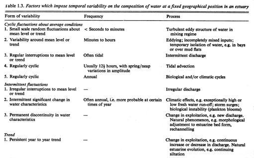
Chapter 8 - pg. 1 CHAPTER 8 ESTUARIES. To paraphrase Pritchard, a pioneer in studies of estuarine circulation,
 Chapter 8 - pg 1 CHAPTER 8 ESTUARIES Estuaries are semi-closed basins in which a rather complex interaction between river inputs, tidal currents and wind leads to the turbulent mixing of salt from the
Unit 4 - Water. Earth s Interior. Earth s Interior. Continental Drift. Continental Drift. Continental Drift. Crust. Mantle. Core.
 Unit 4 - Water How did the oceans form? What special adaptations do saltwater organisms have? Where does our water come from? How do humans affect the Earth s water? Crust Rigid outer shell of Earth Oceanic
GLOBAL WARMING: GLOBAL WARMING. landscape implications. Andrew Goudie St Cross College Oxford
 GLOBAL WARMING: GLOBAL WARMING landscape implications Andrew Goudie St Cross College Oxford THE PROCESS OF CHANGE HAS STARTED IPCC 2007 Increased Glacier retreat since the early 1990s Area of seasonally
Mechanical Weathering
 Weathering is the disintegration and decomposition of material at or near the surface. Erosion is the incorporation and transportation of material by a mobile agent, usually water, wind, or ice. Geologists
Physical Oceanography
 Physical Oceanography SECTION 15.1 The Oceans In your textbook, read about modern oceanography. For each item in Column A, write the letter of the matching item in Column B. e b c d a Column A 1. German
Science 8 Unit 1 Test Review Analyze factors that affect productivity and species distribution in marine and fresh water environments.
 Science 8 Unit 1 Test Review How does water shape our world? 1. Define a water system in your own words 2. What is water important for? (3 things at least) 3. What is water made of? Water in our world
Unit 8 Test Review -- Oceanography
 Unit 8 Test Review -- Oceanography Multiple Choice Identify the choice that best completes the statement or answers the question. D 1. A large body of saline water that may be surrounded by land is a(n)
The Marine Environment
 The Marine Environment SECTION 16.1 Shoreline Features In your textbook, read about erosional landforms, beaches, estuaries, longshore currents, and rip currents. For each statement below, write or. 1.
Laboratory Exercise #3 The Hydrologic Cycle and Running Water Processes
 Laboratory Exercise #3 The Hydrologic Cycle and Running Water Processes page - 1 Section A - The Hydrologic Cycle Figure 1 illustrates the hydrologic cycle which quantifies how water is cycled throughout
water erosion lithosphere Describe the process of erosion and deposition. chemical weathering Dissolving limestone is an example of.
 At one time, there was one large island off the coast of Mississippi and now it is two separate islands. What caused the island to be split into two? water erosion The crust and the top part of the upper
Chapter 3 Sedimentation of clay minerals
 Chapter 3 Sedimentation of clay minerals 3.1 Clay sedimentation on land 3.2 From land to sea 3.3 Clay sedimentation in the sea 1 3.1 Clay sedimentation on land Deserts Glaciers Rivers Lacustrine 2 University
UNIT 5: ECOLOGY Chapter 15: The Biosphere
 CORNELL NOTES Directions: You must create a minimum of 5 questions in this column per page (average). Use these to study your notes and prepare for tests and quizzes. Notes will be stamped after each assigned
Prentice Hall: Science Explorer, 16 Book Series 2005 Correlated to: Alabama Science Standards for Earth and Space Science Core (Grade 6)
") Alabama Science Standards for Earth and Space Science Core (Grade 6) 1. Identify global patterns of atmospheric movement, including El Niño, the Gulf Stream, the jet stream, the Coriolis effect, and global
Alabama Science Standards for Earth and Space Science Core (Grade 6) 1. Identify global patterns of atmospheric movement, including El Niño, the Gulf Stream, the jet stream, the Coriolis effect, and global
Lecture 13 More Surface Reactions on Mineral Surfaces. & Intro to Soil Formation and Chemistry
 Lecture 13 More Surface Reactions on Mineral Surfaces & Intro to Soil Formation and Chemistry 3. charge transfer (e.g., ligand/donor sorption): Sorption involves a number of related processes that all
Hydrological Cycle Rain and rivers OUTLINE
 Hydrological Cycle Rain and rivers The Hydrosphere Rain and rivers OUTLINE 1 Generalizations (non-political conservatism) Conservative (not affected) and Non-Conservative (affected) Ions Distinction: whether
ARE YOU READY TO THINK? Look at the first slide THINK PAIR SHARE!
 ARE YOU READY TO THINK? Look at the first slide THINK PAIR SHARE! WHAT PROMINENT FEATURE CAN YOU IDENTIFY IN THIS PICTURE? What do you think the different colors represent? Who might find such a picture
GEOL 1121 Earth Processes and Environments
 GEOL 1121 Earth Processes and Environments Wondwosen Seyoum Department of Geology University of Georgia e-mail: seyoum@uga.edu G/G Bldg., Rm. No. 122 Seyoum, 2015 Chapter 6 Streams and Flooding Seyoum,
Lecture Outlines PowerPoint. Chapter 5 Earth Science 11e Tarbuck/Lutgens
 Lecture Outlines PowerPoint Chapter 5 Earth Science 11e Tarbuck/Lutgens 2006 Pearson Prentice Hall This work is protected by United States copyright laws and is provided solely for the use of instructors
Energy Systems, Structures and Processes Essential Standard: Analyze patterns of global climate change over time Learning Objective: Differentiate
 Energy Systems, Structures and Processes Essential Standard: Analyze patterns of global climate change over time Learning Objective: Differentiate between weather and climate Global Climate Focus Question
ES120 Sedimentology/Stratigraphy
 Midterm Exam 5/05/08 NAME: 1. List or describe 3 physical processes that contribute to the weathering of rocks (3pts). exfoliation frost wedging many others. roots, thermal expansion/contraction also credit
TAKE HOME EXAM 8R - Geology
 Name Period Date TAKE HOME EXAM 8R - Geology PART 1 - Multiple Choice 1. A volcanic cone made up of alternating layers of lava and rock particles is a cone. a. cinder b. lava c. shield d. composite 2.
Ecosystems Chapter 4. What is an Ecosystem? Section 4-1
 Ecosystems Chapter 4 What is an Ecosystem? Section 4-1 Ecosystems Key Idea: An ecosystem includes a community of organisms and their physical environment. A community is a group of various species that
Fresh Water: Streams, Lakes Groundwater & Wetlands
 Fresh Water:, Lakes Groundwater & Wetlands Oct 27 Glaciers and Ice Ages Chp 13 Nov 3 Deserts and Wind and EXAM #3 Slope hydrologic cycle P = precip I = precip intercepted by veg ET = evapotranspiration
Ocean and Coastal Processes. Ocean Basins. Chapter 20. Ocean Basins and Plates. Ocean Terms. Sea Arch Bay-mouth Bar Spit Tombolo Coast.
 Chapter 20 Ocean Basins and Plates Ocean and Coastal Processes Tide Wave Height Length Period Base Refraction Tsunami Beach Sea stack Ocean Terms Sea Arch Bay-mouth Bar Spit Tombolo Coast Emergent Submergent