MultiHazard Process Chains: Nepal and other hotspots
|
|
|
- Damon Mitchell
- 6 years ago
- Views:
Transcription
1 MultiHazard Process Chains: Nepal and other hotspots Jeffrey S. Kargel (Thanks to NASA Disasters program and David Green for support) 6 Sep 2016 Glaciers Glacial Lakes Seismicity Meteorological floods Volcanoes
2 (1) Future possible CEOS/GEO pilots on high mountain disaster risks -- Regions proposed for CEOS multihazard extended monitoring/analysis: i) Nepal Himalaya and transborder areas of Tibet and India: seismic-landslideglacier-glacial lake-meteorological hazards (major hazard points/examples: Imja Lake, Lower Barun Lake, Rolpa Lake, Kodari Pass, Koshi Tappu wetlands) ii) Cascades: volcano-seismic-meteorological-landslide-glacier hazards (major hazard points, examples: Mts Rainier, Hood, Baker, and downstream areas) iii) Northern Andes (Colombia-Ecuador-Peru): volcano-seismic-landslideglacier-glacial lake-meteorological hazards, imopacts on people, infrastructure, and ecosystems (major hazard points, examples: Cordillera Blanca (glaciers and lakes), Corapuna (Peru), Cotopaxi (Ecuador), Nevado del Ruiz (Colombia), others) -- Nepal examples: i) Gorkha earthquake glacier-landslide-river blocking, ii) Gorkha earthquake-ice avalanche-glacial lake outburst hazard, iii) Monsoon and construction related landslides and dammed lake outbursts (2) NASA-supported, CEOS-related high mountain disaster workshops: -- Satellite Observations Could Cover Multi-Process Glacier Hazard and Disaster Hotspots: Nepal, Cascades, and Northern Andes, pre-agu, Dec. 11, San Fran. -- Satellite Observations to Cover Multi-Process Glacier Hazards and Disasters Hotspot in the Nepal Himalaya, Kathmandu, Nov. 2, 3, or 4 possible. (3) HMA team, tool development: Glacier Lake Accelerated Melting (GLAM)


3 Palcacocha Aluviones in Huaraz: 1702, 1725, 1869, 1941, 1952, 2003 Huaraz

")
")

4 Nevado del Ruiz, Colombia lahars, tragedy (23,000 killed) and Coropuna, Peru (6377 m) seismicity, heat flow, eruption history, next tragedy?

 blocked river")

5 Taplejung landslides, June 10-11, 2015: Steep slopes + monsoon = deadly landslides (57 killed) blocked river landslide dammed lake outburst flood killed fish wild swings in price of fish


6 Construction on slopes + Geological weaknesses + monsoon +- earthquake = Landslides + lost hydropower production (economic losses) Far Eastern Nepal: 5 MW run-of-the-river hydropower plant construction and recurrent problems with landslides.
 Enormous ice lossses have occurred 300 m thinning 19 th century")
7 16 ka 24 ka moraine (Periche I moraine, Finkel et al. 2003) Enormous ice lossses have occurred 300 m thinning 19 th century ice-cored end moraine

8 Growth of Imja Lake, Nepal,

9

10 The sine function would produce a scattering of points about the polynomial curve that roughly matches the disperson around the curve.
11

12 Measurement errors are probably overestimated
 9655 - Omitted points: (-1338) - USV validated points: 8317-2014 Total (ice bore measure) 61 - Omitted")
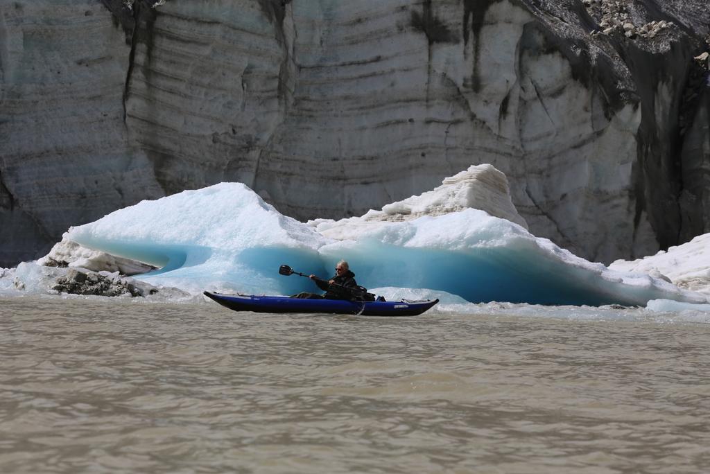
 10,020 - Omitted points: (-854) - Boat validated points: 9,166 - TOTAL VALIDATED: 41,040 3335 Black: our USV and kayak survey Red: Somos et al.")
13 Imja / Amphulapcha Lakes, Nepal: 2014 & 2012 Data Sounding Points Imja Lakes Amphu Lapcha Lake 2014 Total (kayak-mount) 53, Omitted points: (-30,354) (-886) Kayak validated points: 23, Total (USV-mount) Omitted points: (-1338) - USV validated points: Total (ice bore measure) 61 - Omitted points: (-28) - Ice bore validated points: Somos et al. Total (boat-mount) 10,020 - Omitted points: (-854) - Boat validated points: 9,166 - TOTAL VALIDATED: 41, Black: our USV and kayak survey Red: Somos et al (survey date 2012) Yellow: Our plumb line measurements Details at west end of Imja lake and ponds on the end moraine

14 Imja Lake bathymetry, Oct 2014


15 Glacier and High Mountain Hazard Dynamics in Nepal Thulagi L. Imja L. Lower Barun L. Thulagi L. Lower Barun L. Imja L. Thulagi Lake bathymetry, glacier dynamical assessment, hydrological and energy balance modeling Lower Barun Lake bathymetry, glacier flow speed assessment Imja Lake and glacier dynamics and the Imja Lake lowering project
16 Community Based Flood and Glacial Lake Outburst Risk Reduction Project (CFGORRP) Implementing Authority Nepal Army

17


18


19


20 Gorkha earthquake multihazard process chains M7.8 quake on April 25, 2015, epicenter west of Kathmandu, ~12 km deep, blind fault M7.3 aftershock on May 12, ~9000 killed, 97% of fatalities in Nepal. Others in India, China, and Bangladesh. >4300 significant landslides/ice avalanches. Some dangerous river blockages, upstream inundation floods, and landslide dammed lake outburst floods Many glacial lakes are in the heavily shaken zone: but no seismic aluviones! Destroyed temple in Kathmandu


 Pre-quake,")
21 Earthquake-triggered snow, ice and debris avalanche and potential river blocking, starting with ridge-top failure (PGA ~0.12 g) Pre-quake, Digital Globe/Google Earth

")


22 Post- and pre-earthquake image pair. The landslide is bright red. Above: WorldView satellite image, May 8. NDWI technique was used to map the lake (red outline) and distinguish it from shadow. Societal Concern: The concern was that an outburst flood could reach downstream villages (Ghapsya village 3.1 miles, Ghap village 3.7 miles, terraced agricultural fields 2.5 miles, 3.7 miles Nepal/Tibet border). The lake drained naturally, with little damage.

23 Langtang Valley landslides

24 Devastating landslide pathway, Langtang village Photos by David Breashears/GlacierWorks, Mosaic by Dan Shugar In J. Kargel and 63 others, SCIENCE (2016)


25 Sentinel 1 InSAR displacement, pre- and post-quake
26 Devastating landslide, Langtang village Photos by David Breashears/GlacierWorks Before/after image pair
27 Devastating landslide, Langtang village Photos by David Breashears/GlacierWorks Before/after image pair
28 Devastating landslide, Langtang village Photos by David Breashears/GlacierWorks Before/after image pair
29 Devastating landslide, Langtang village Photos by David Breashears/GlacierWorks Before/after image pair
30 Devastating landslide, Langtang village Photos by David Breashears/GlacierWorks Before/after image pair
31 Devastating landslide, Langtang village Photos by David Breashears/GlacierWorks Before/after image pair
32 Devastating landslide, Langtang village Photos by David Breashears/GlacierWorks Before/after image pair
33 Devastating landslide, Langtang village Photos by David Breashears/GlacierWorks Before/after image pair

34 Devastating landslide, Langtang village Photos by David Breashears/GlacierWorks Before/after image pair

35 Devastating landslide, Langtang village Photos by David Breashears/GlacierWorks Before/after image pair

36 Proximal deposit, Langtang village Photo by David Breashears/GlacierWorks


37 Airblast zone, Langtang village Photo by David Breashears/GlacierWorks

38 Airblast zone, blown-down forest, Langtang Valley Photo by Randall Jibson/USGS
.")
39 4312 landslides mapped by a large volunteer team of satellite image analysts (Kargel et al. 2016). Their distribution is bookended by the primary M7.8 shock and the largest aftershock (M7.3). 98% of landslides occurred where shaking PGA > 0.16 g.

40

41 Glacial lakes show very few effects. No evidence of seismically and landslide triggered drainage. Fig. 12 in Kargel and 63 others, 2016, SCIENCE


42 Detailed systematic survey for damage done by shaking of glacial lakes lakes observed -- Koji Fujita/students -- Umesh Haritashya/students -- 9 had some minor rockfalls -- No lakes experienced an observable outburst
43 Gorkha earthquake effects on glacial lakes Prior expectations were that a M7.8 earthquake and M7.3 aftershock situated near glacial lakes would have caused damage and aluviones (glacial lake outburst floods) Minor damage (cracking) observed on engineered parts of the Tsho Rolpa moraine dam. No aluviones occurred! Why? -- Fewer landslides than anticipated = fewer potential triggers -- Topography shielding (scattering and absorption of seismic waves). -- Seismic wave attenuation in valleys Number and severity of seismically induced geohazards depend on earthquake details, specific geometry of mountain slopes and glacial lakes relative to the quake epicnter and hypocenter.
44 Thank you!
GLACIAL LAKE OUTBURST FLOODS IN THE NEPAL HIMALAYA JONATHAN M LALA UNIVERSITY OF TEXAS AT AUSTIN CE 394K.3 GIS IN WATER RESOURCES DECEMBER 2, 2016
 GLACIAL LAKE OUTBURST FLOODS IN THE NEPAL HIMALAYA JONATHAN M LALA UNIVERSITY OF TEXAS AT AUSTIN CE 394K.3 GIS IN WATER RESOURCES DECEMBER 2, 2016 TABLE OF CONTENTS Abstract... 3 Introduction... 3 Methods...
Skeletal remains of what was a debris-covered glacier near Mt. Everest
 Annual satellite imaging of the world s glaciers Assessment of glacier extent and change GLIMS Development and population of a digital glacier data inventory HIGH ICE Skeletal remains of what was a debris-covered
Report on Disaster statistics of Nepal
 Report on Disaster statistics of Nepal Submitted by Altaf Rehman Submitted to Dr. Naveed Ahmed University of engineering and technology Peshawar Assignment 1 Section A Registration id 14PWCIV456 Page 1
Debris flow: categories, characteristics, hazard assessment, mitigation measures. Hariklia D. SKILODIMOU, George D. BATHRELLOS
 Debris flow: categories, characteristics, hazard assessment, mitigation measures Hariklia D. SKILODIMOU, George D. BATHRELLOS Natural hazards: physical phenomena, active in geological time capable of producing
Debris Avalanches. Debris avalanche deposits on a volcano in Chile. All of the area in the foreground is buried by a thick debris avalanche.
 Debris Avalanches Volcanoes are not very stable structures. From time to time, they collapse producing large rock and ash avalanches that travel at high speeds down valleys. Collapse maybe caused by an
How to manage risk through integrated geohazard assessment. Prof. John M. Reynolds Reynolds International Ltd, Mold, UK
 How to manage risk through integrated geohazard assessment Prof. John M. Reynolds Reynolds International Ltd, Mold, UK Talk outline Introduction Types of disasters within the Himalayas Integrated Geohazard
Volcanoes and Urban Planning
 Background Reading & Lesson Plan Document ID: 10_04_04_1 Date Received: 2004-10-04 Date Revised: 2004-11-16 Date Accepted: 2004-11-23 Curriculum Topic Benchmarks: M1.3.5, M3.3.17, M5.3.3, M9.3.2, S12.3.7,
DISASTER HAZARDS IN BHUTAN By Tshewang Rinzin January Reducing Disaster Risks for a Safe and Happy Bhutan
 DISASTER HAZARDS IN BHUTAN By Tshewang Rinzin 26-27 January 2009 Reducing Disaster Risks for a Safe and Happy Bhutan Disaster Hazards in Bhutan Earthquakes Glacial Lake Outburst Flood (GLOF) Floods in
Orting Community College Proposal
 Orting Community College Proposal Cedric, Celina, Francine, Sarah, Samuel GEO CORP Located in Washington, 42 miles south of Seattle. Situated between two rivers on fertile plains. Built on lahar deposits.
Natural Disaster Preparedness for Hydropower Projects in High Mountain Environments
 Natural Disaster Preparedness for Hydropower Projects in High Mountain Environments John M. Reynolds Reynolds International Ltd Suite 2, Broncoed House Broncoed Business Park Wrexham Road Mold Flintshire
GEOLOGY 285: INTRO. PETROLOGY
 Dr. Helen Lang Dept. of Geology & Geography West Virginia University FALL 2005 GEOLOGY 285: INTRO. PETROLOGY Mount St. Helens 1980 Eruption Small earthquakes Small steam and ash eruptions in March and
Geotechnical damage in rural areas caused by the 2015 Gorkha Nepal Earthquake
 Tokyo, 1 June 2015 Geotechnical damage in rural areas caused by the 2015 Gorkha Nepal Earthquake Chiaro Gabriele JSPS RESEARCH FELLOW, University of Tokyo Lecturer, University of Canterbury, New Zealand
The Cascading Hazards from Cascadia s Earthquakes
 Tsunamis The Cascading Hazards from Cascadia s Earthquakes Earthquakes (Nisqually earthquake, Seattle, WA) Volcanoes (Mt St Helens eruption, WA) Joan Gomberg gomberg@usgs.gov Landslides (Oso landslide,
Flood Inundation Mapping under different climate change scenarios in the upper Indus River Basin, Pakistan
 Flood Inundation Mapping under different climate change scenarios in the upper Indus River Basin, Pakistan Sohaib Baig (doctoral student) 16 November 2017 Disaster Prevention Research Institute 1 Kyoto
Interpretive Map Series 24
 Oregon Department of Geology and Mineral Industries Interpretive Map Series 24 Geologic Hazards, and Hazard Maps, and Future Damage Estimates for Six Counties in the Mid/Southern Willamette Valley Including
Also, when Cascade volcanoes do erupt, high-speed avalanches of pyroclastic flows
 INTRODUCTION A volcano is a vent through which molten rock escapes to the Earth s surface. Unlike other mountains, which are pushed up from below, volcanoes are built by surface accumulation of their eruptive
ICIMOD Responding to Mountain Challenges in the Hindu Kush- Himalayas
 ICIMOD Responding to Mountain Challenges in the Hindu Kush- Himalayas Eklabya Sharma International Centre for Integrated Mountain Development Kathmandu, Nepal Regional Intergovernmental Learning and Knowledge
Recent extreme weather events in the Nepal Himalayas
 The Extremes ofthe Extremes: Extraordinary Floods (Proceedings of n symposium held al Reykjavik. Iceland. July 2000). lalispubl.no. 271. 2002. 141 Recent extreme weather events in the Nepal Himalayas SURESH
On the need to integrate Disaster Risk Management within the hydropower sector
 On the need to integrate Disaster Risk Management within the hydropower sector John M. Reynolds Reynolds International Ltd Suite 2, Broncoed House Broncoed Business Park Wrexham Road Mold Flintshire CH7
3.12 Geology and Topography Affected Environment
 3 Affected Environment and Environmental Consequences 3.12 Geology and Topography 3.12.1 Affected Environment 3.12.1.1 Earthquakes Sterling Highway MP 45 60 Project Draft SEIS The Kenai Peninsula is predisposed
Geo-information and Disaster Risk Reduction in the Hindu Kush-Himalayan region
 Geo-information and Disaster Risk Reduction in the Hindu Kush-Himalayan region Basanta Shrestha, Division Head MENRIS, International Centre for Integrated Mountain Development Kathmandu, Nepal The International
Hazard Zonation for Glacial Lake Outburst Flood (GLOF) in Bhutan Himalaya
 in Bhutan Himalaya") Hazard Zonation for Glacial Lake Outburst Flood (GLOF) in Bhutan Himalaya A mode of Adaptation to the impacts of climate change DGM-NCAP Project Karma Department of Geology & Mines Ministry of Economic
Hazard Zonation for Glacial Lake Outburst Flood (GLOF) in Bhutan Himalaya A mode of Adaptation to the impacts of climate change DGM-NCAP Project Karma Department of Geology & Mines Ministry of Economic
Nevado Del Ruiz, Lahars
 Nevado Del Ruiz, 1985 - Lahars Lecture Objectives -Basics of lahars: definition, characteristics -Ruiz case study: hazards, impacts Mt. Pinatubo lahar footage by Mike Dolan (MTU) Mt. Pinatubo lahar footage
FIRST GRADE HAZARDS 1 WEEK LESSON PLANS AND ACTIVITIES
 FIRST GRADE HAZARDS 1 WEEK LESSON PLANS AND ACTIVITIES PLATE TECTONIC CYCLE OVERVIEW OF FIRST GRADE VOLCANOES WEEK 1. PRE: Learning the shapes of volcanoes. LAB: Experimenting with "lava." POST: Comparing
Dealing with climate-change impacts on glacier and permafrost hazards: adaptation strategies in mountain regions
 Dealing with climate-change impacts on glacier and permafrost hazards: adaptation strategies in mountain regions Christian Huggel Luzia Fischer, Wilfried Haeberli, Stephan Gruber, Jeannette Nötzli Glaciology
Earthquake hazards. Aims 1. To know how hazards are classified 2. To be able to explain how the hazards occur 3. To be able to rank order hazards
 Earthquake hazards Aims 1. To know how hazards are classified 2. To be able to explain how the hazards occur 3. To be able to rank order hazards Types of hazard Primary A direct result of the earthquake
MULTI-HAZARD RISK ASSESSMENT AND DECISION MAKING
 MULTI-HAZARD RISK ASSESSMENT AND DECISION MAKING JULINDA KEÇI Epoka University Logo of the institution CONTENT: Introduction Multi Hazard Risks Multi-Hazard Risk Assessment Quantitative Assessment Event
Volcanoes. Introduction
 Volcanoes Introduction Display Slide V-0 Explain that a volcano is a vent through which molten rock escapes to the Earth s surface. Unlike other mountains, which are pushed up from below, volcanoes are
Geohazards in the Himalaya GEOL 3000 (3 Credits / 45 class hours)
") Geohazards in the Himalaya GEOL 3000 (3 Credits / 45 class hours) SIT Study Abroad Program: Nepal: Geoscience in the Himalaya PLEASE NOTE: This syllabus represents a recent term. Because courses develop
Geohazards in the Himalaya GEOL 3000 (3 Credits / 45 class hours) SIT Study Abroad Program: Nepal: Geoscience in the Himalaya PLEASE NOTE: This syllabus represents a recent term. Because courses develop
Role of Hydro-Met Services in Disaster Risk Management
 Role of Hydro-Met Services in Disaster Risk Management Tshewang Rigzin (Mr) National Centre for Hydrology and Meteorology, Bhutan 30 th November 2017 Outline Vision and Mission Functions related to Disaster
UGRC 144 Science and Technology in Our Lives/Geohazards
 UGRC 144 Science and Technology in Our Lives/Geohazards Session 6 Volcanic Hazards Lecturer: Dr. Patrick Asamoah Sakyi Department of Earth Science, UG Contact Information: pasakyi@ug.edu.gh College of
CEOS Landslide Pi lot Working Group: An Overview
 Committee on Earth Observation Satellites CEOS Landslide Pi lot Working Group: An Overview September 4 th, 2017 Co-leads of landslide pilot Dr. Dalia Kirschbaum, NASA Goddard Space Flight Center, Maryland,
New Topic Today. Mass Movement = Mass Wasting. =colluvial processes =slope processes =slope failures =LANDSLIDES. Landslides by U.S.
 New Topic Today Mass Movement = Mass Wasting =colluvial processes =slope processes =slope failures =LANDSLIDES U.S. Landslide Risk Which states have lots of landslide damage? Landslides by U.S. Region
Erupted and killed approximately 15,000 people 200 years ago
 1 2 3 4 5 6 7 8 Introduction to Environmental Geology, 5e Chapter 8 Volcanic Activity Volcanoes: summary in haiku form A volcano forms. Magma comes to the surface - explodes, if felsic. Case History: Mt.
Urgent Report of the Landslide Disasters by the Mid Niigata Prefecture Earthquake in 2004, Japan
 Urgent Report of the Landslide Disasters by the Mid Niigata Prefecture Earthquake in 2004, Japan Investigation Commission of the Japan Landslide Society and the Japanese Society of Engineering Geology
GG101 Lecture 22: Mass Wasting. Soil, debris, sediment, and broken rock is called regolith.
 GG101 Lecture 22: Mass Wasting Mass Wasting is the movement of rock and soil down a slope due to the force of gravity. Soil, debris, sediment, and broken rock is called regolith. Mass wasting creates broad
OIKOS > landslide > mechanism >predisposing causes
 predisposing causes and trigger OIKOS > landslide > mechanism >predisposing causes Landslides are events that occur in space and time. As such, it is usually possible to identify both one or more landslide
Geohazards and disaster risk reduction
 Geohazards and disaster risk reduction Susanne Sargeant 8 November 2017 Overview University and my PhD Seismology at BGS Learning other skills Working at the interface between science and resilience building
Location Option Details. 1. Florida
 1. Florida Florida has the smallest number of earthquaes in the United States. Florida is the U.S. location where hurricanes are most frequent. Of the six deadliest hurricanes to hit the continental U.S.,
SIMPLE GUIDELINES TO MINIMISE EXPOSURE TO EARTHQUAKE-TRIGGERED LANDSLIDES
 SIMPLE GUIDELINES TO MINIMISE EXPOSURE TO EARTHQUAKE-TRIGGERED LANDSLIDES David Milledge, Nick Rosser, Katie Oven, Amod Mani Dixit, Ranjan Dhungel, Gopi Krishna Basyal, Sujan Raj Adhikari and Alexander
Chapter Introduction Lesson 1 Earthquakes Lesson 2 Volcanoes Chapter Wrap-Up
 Chapter Introduction Lesson 1 Earthquakes Lesson 2 Volcanoes Chapter Wrap-Up What causes earthquakes and volcanic eruptions? What do you think? Before you begin, decide if you agree or disagree with each
GENERAL. CHAPTER 1 BACKGROUND AND PURPOSE OF THE GUIDELINES Background of the Guidelines Purpose of the Guidelines...
 GENERAL CHAPTER 1 BACKGROUND AND PURPOSE OF THE GUIDELINES... 1 1.1 Background of the Guidelines... 1 1.2 Purpose of the Guidelines... 3 CHAPTER 2 APPLICATION OF THE GUIDELINES... 3 2.1 Potential Users
New Topic Today. Mass Movement = Mass Wasting. =colluvial processes =slope processes =slope failures =LANDSLIDES. Landslides by U.S.
 New Topic Today Mass Movement = Mass Wasting =colluvial processes =slope processes =slope failures =LANDSLIDES U.S. Landslide Risk Which states have lots of landslide damage? Landslides by U.S. Region
2/25/2013. Volcanoes: summary in haiku form A volcano forms. Magma comes to the surface - explodes, if felsic.
 Introduction to Environmental Geology, 5e Edward A. Keller Chapter 8 Volcanic Activity Volcanoes: summary in haiku form A volcano forms. Magma comes to the surface - explodes, if felsic. Lecture Presentation
Gateway Trail Project
 Gateway Trail Project Debris Flow Hazard Assessment By: Juan de la Fuente April 30, 2010 Background- On April 22, 2010, the Shasta-Trinity National Forest (Mt. Shasta-McCloud Unit) requested a geologic
Major External Processes Driven by energy from the sun and from gravity. Also create hazards and resources.
 Geologic Processes and Hazards Definition of Geology External and Internal Processes: examples of each Fundamentals of Plate Tectonics: definition, types of boundaries, general geography, hazards & resources
GEOL1 Physical Geology Laboratory Manual College of the Redwoods Lesson Five: Volcanoes Background Reading: Volcanoes Volcanic Terms: Silca:
 Name: Date: GEOL1 Physical Geology Laboratory Manual College of the Redwoods Lesson Five: Volcanoes Background Reading: Volcanoes Volcanic Terms: Silca: SiO 2 silicon dioxide. This is quartz when it crystallizes.
HAZARD IDENTIFICATION AND VULNERABILITY ANALYSIS (HIVA) Walla Walla County, Washington VOLCANO ASH FALL
 Walla Walla County, Washington VOLCANO ASH FALL") HAZARD IDENTIFICATION AND VULNERABILITY ANALYSIS (HIVA) Walla Walla County, Washington VOLCANO ASH FALL Hazard Overview A volcano is a vent in the earth's crust through which magma (molten rock), rock
HAZARD IDENTIFICATION AND VULNERABILITY ANALYSIS (HIVA) Walla Walla County, Washington VOLCANO ASH FALL Hazard Overview A volcano is a vent in the earth's crust through which magma (molten rock), rock
Physical Geography of East Asia
 Physical Geography of East Asia Satellite View of China Landforms of China China s Geography China Miles 0 250 500 1,000 1,500 2,000 United States 3 rd largest country in the world. Comparable to the US
Bhutan Country Report for JPTM 2010 (July, 2010) Department of Disaster Management Ministry of Home & Cultural Affairs Royal Government of Bhutan
 Department of Disaster Management Ministry of Home & Cultural Affairs Royal Government of Bhutan") Bhutan Country Report for JPTM 2010 (July, 2010) Department of Disaster Management Ministry of Home & Cultural Affairs Royal Government of Bhutan 1 Contents of Presentation 1. Disaster Hazards and Underlying
Bhutan Country Report for JPTM 2010 (July, 2010) Department of Disaster Management Ministry of Home & Cultural Affairs Royal Government of Bhutan 1 Contents of Presentation 1. Disaster Hazards and Underlying
Down-stream process transition (f (q s ) = 1)
 = 1)") Down-stream process transition (f (q s ) = 1) Detachment Limited S d >> S t Transport Limited Channel Gradient (m/m) 10-1 Stochastic Variation { Detachment Limited Equilibrium Slope S d = k sd A -θ d S
Down-stream process transition (f (q s ) = 1) Detachment Limited S d >> S t Transport Limited Channel Gradient (m/m) 10-1 Stochastic Variation { Detachment Limited Equilibrium Slope S d = k sd A -θ d S
Nepal earthquake of April 25, 2015
 University of Wollongong Research Online Faculty of Engineering and Information Sciences - Papers: Part A Faculty of Engineering and Information Sciences 2015 Nepal earthquake of April 25, 2015 T G Sitharam
Geologic Evolution of the Skagit River Channel Migration Zone. J. Riedel National Park Service
 Geologic Evolution of the Skagit River Channel Migration Zone J. Riedel National Park Service LSWT BT OT CMZ defined by: 1) Areas within FEMA floodplain of Skagit River (100 and 500 year); 2) Areas within
Satellite Earth Observation - Educational initiatives of Belgian Science Policy 10 YEARS OF IMAGING ASIA SPOT VEGETATION
 The Neverending Battle with Nature Natural disasters occur everywhere in the world, in all their various forms: earthquakes, volcanoes, tsunamis, hurricanes, floods... Their appearance naturally largely
Geohazards in the Himalaya GEOL 3000 (3 Credits / 45 class hours)
") Geohazards in the Himalaya GEOL 3000 (3 Credits / 45 class hours) SIT Study Abroad Program: Nepal: Geoscience in the Himalaya PLEASE NOTE: This syllabus represents a recent term. Because courses develop
Geohazards in the Himalaya GEOL 3000 (3 Credits / 45 class hours) SIT Study Abroad Program: Nepal: Geoscience in the Himalaya PLEASE NOTE: This syllabus represents a recent term. Because courses develop
Integrated and Multi-Hazard Disaster Management
 GeoSmart Asia 2016: GI for Disaster Preparedness and Risk Reduction Bandung, Indonesia 12 October 2016 Integrated and Multi-Hazard Disaster Management Lim Choun Sian & Nurfashareena Muhamad Centre for
Earthquake Hazards. Tsunami
 Earthquake Hazards Tsunami Review: What is an earthquake? Earthquake is the vibration (shaking) and/or displacement of the ground produced by the sudden release of energy. The point inside the Earth where
PHYSICAL GEOGRAPHY. By Brett Lucas
 PHYSICAL GEOGRAPHY By Brett Lucas INTERNAL PROCESSES Internal Processes The Impact of Internal Processes on the Landscape From Rigid Earth to Plate Tectonics Plate Tectonics Vulcanism Diastrophism Folding
Hazards in the Seattle Area. Disaster Questions. Where Were You? Where Were You? Volcanoes St. Helens Adams, Rainier, Glacier, Baker
 Hazards in the Seattle Area Volcanoes St. Helens Adams, Rainier, Glacier, Baker Earthquakes Outer coast Puget Sound (Seattle Fault & others) Tsunami Outer coast Puget Sound (Seattle Fault & others) Disaster
Natural Disasters Spring, LECTURE #8: Earthquake Disasters: Monitoring & Mitigation. Date: 1 Feb 2018 (lecturer: Dr.
 GEOL 0820 Ramsey Natural Disasters Spring, 2018 LECTURE #8: Earthquake Disasters: Monitoring & Mitigation Date: 1 Feb 2018 (lecturer: Dr. Shawn Wright) I. Exam I - Reminder Feb 6 th next class details:
Country Report Nepal Geospatial Data Sharing Initiatives of Survey Department Supporting Disaster Management
 Third JPTM Step 2 for Sentinel Asia 6-8 July, 2010 Manila, The Philippines Country Report Nepal Geospatial Data Sharing Initiatives of Survey Department Supporting Disaster Management Durgendra M Kayastha
Attabad landslide crisis in Hunza, Pakistan lessons for the management of valley blocking landslides. Dave Petley
 Attabad landslide crisis in Hunza, Pakistan lessons for the management of valley blocking landslides Dave Petley Durham University, United Kingdom Thanks to: D. Karim, S. Wali, N. Ali, N. Nasab & K. Shaban
Overview of Philippine Geohazards Programs
 Overview of Philippine Geohazards Programs 53 rd CCOP Annual Session CCOP-IUGS Task Group on Geohazards Joint Seminar Cebu City, PHILIPPINES October 18, 2017 Renato U. Solidum, Jr. Department of Science
Predicting and Preparing for Volcanoes
 Predicting and Preparing for Volcanoes Prediction methods for volcanic eruptions are more reliable than those for earthquakes. Some volcanoes such as Mount Etna in Italy are monitored all of the time because
Unsafe Ground: Landslides and Other Mass Movements. Chapter 11. Selected landslides (causes & number of deaths) Weathering, Erosion & Mass Wasting
 Weathering, Erosion & Mass Wasting") Weathering, Erosion & Mass Wasting Chapter 11 Weathering produces all the soils, clays, sediments, and dissolved substances. Mass Wasting Erosion is the removal of sediments by natural processes e.g. wind,
Weathering, Erosion & Mass Wasting Chapter 11 Weathering produces all the soils, clays, sediments, and dissolved substances. Mass Wasting Erosion is the removal of sediments by natural processes e.g. wind,
Mass Movement and Surface Karst
 LAB #1 Mass Movement and Surface Karst Recommended Textbook Reading Prior to Lab: Chapter 15, Weathering and Mass Movement 15.2 Dissolving Rock: Karst 15.3 Unstable Ground: Mass Movement Goals: After completing
Data challenges in Trans-boundary River Basins: Case Study of the Upper Indus Basin
 Data challenges in Trans-boundary River Basins: Case Study of the Upper Indus Basin Asif Khan Lead Author (Water chapter- AR6 IPCC) Post Doctorate (Water-Energy-Food-Climate Change, IIASA, Austria) PhD
Mass Wasting: The Work of Gravity
 Chapter 15 Lecture Earth: An Introduction to Physical Geology Twelfth Edition Mass Wasting: The Work of Gravity Tarbuck and Lutgens Chapter 15 Mass Wasting The Importance of Mass Wasting Slopes are the
Magnitude 7.3 NEPAL. Tuesday, May 12, 2015 at 07:05:19 UTC
 A magnitude 7.3 earthquake has occurred near Mount Everest. Early reports suggest 32 people have been killed and at least 1,000 were injured in the earthquake. The region is still in recovery from a 7.8
The Orting Community College of Vulcanology
 The Orting Community College of Vulcanology A Recommendation For His Honourable Mayor A. Young By DAG (Doom-and-Gloom), LLP (Michael, Chris, Bryan, Lauren, Dave) Agenda 1. 2. 3. 4. 5. 6. Description of
Disaster RISK Management : Bhutanese Scenario
 Disaster RISK Management : Bhutanese Scenario Expert Group Meeting (EGM) on Geo-referenced Information Systems for Disaster Risk Management (Geo-DRM) and sustaining the Community of Practice (COP), Bangkok,
Volcanic Hazards & Prediction of Volcanic Eruptions
 Page 1 of 11 EENS 3050 Tulane University Natural Disasters Prof. Stephen A. Nelson Volcanic Hazards & Prediction of Volcanic Eruptions This page last updated on 04-Oct-2016 Volcanic Hazards This lecture
AND. A GEOMORPHOLOGIST SVIEWS HERMAN Th. VERSTAPPEN. International Institute for Geoinformation. Enschede the Netherlands
 NATURAL DISASTER REDUCTION AND ENVIRONMENTAL MANAGEMENT A GEOMORPHOLOGIST SVIEWS HERMAN Th. VERSTAPPEN Em. Professor of Geomorphology International Institute for Geoinformation Science and Earth Observation
GEOSPATIAL ANALYSIS OF GLACIAL DYNAMICS OF SHIGAR AND SHAYOK BASINS. Syed Naseem Abbas Gilany 1
 GEOSPATIAL ANALYSIS OF GLACIAL DYNAMICS OF SHIGAR AND SHAYOK BASINS 1 OUTLINE Introduction Problem Statement / Rationale Objectives Material and Methods Study Area Datasets Required Data Analysis / Assessment
Earth Structures and Processes Teacher Notes
 Aleutian Islands String of islands resulting from volcanic activity Part of the Pacific Ring of Fire Coast is very jagged and rocky with steep cliffs and mountains Underwater eruptions form new landforms
USING 3D GIS TO ASSESS ENVIRONMENTAL FLOOD HAZARDS IN MINA
 King Fahd University of Petroleum & Minerals College of Environmental Design Geographical Information system USING 3D GIS TO ASSESS ENVIRONMENTAL FLOOD HAZARDS IN MINA Prepared by : Ali AL-Zahrani OUTLINE
The 2011 Tohoku earthquake and dams
 The 2011 Tohoku earthquake and dams N. Matsumoto & T. Sasaki Japan Dam Engineering Center, Japan T. Ohmachi Tokyo Institute of Technology, Japan ABSTRACT: The magnitude 9.0 Tohoku earthquake occurred on
GUIDELINES FOR CONSTRUCTION TECHNOLOGY TRANSFER DEVELOPMENT OF WARNING AND EVACUATION SYSTEM AGAINST SEDIMENT DISASTERS IN DEVELOPING COUNTRIES
 GUIDELINES FOR CONSTRUCTION TECHNOLOGY TRANSFER DEVELOPMENT OF WARNING AND EVACUATION SYSTEM AGAINST SEDIMENT DISASTERS IN DEVELOPING COUNTRIES MARCH 2004 Ministry of Land, Infrastructure and Transport
Climate Changes and Natural Hazards in Mountain Areas, Mountainhazards 2011 Dushanbe, Tajikistan
 Climate Changes and Natural Hazards in Mountain Areas, Mountainhazards 2011 Dushanbe, Tajikistan Title: GLOF Risk Assessment in Hindu Kush-Himalayas (HKH) Region in the Era of Climate Change Ashutosh Mohanty
Mountain Rivers. Gutta cavat lapidem. (Dripping water hollows out a stone) -Ovid, Epistulae Ex Ponto, Book 3, no. 10, 1. 5
 -Ovid, Epistulae Ex Ponto, Book 3, no. 10, 1. 5") Mountain Rivers Gutta cavat lapidem (Dripping water hollows out a stone) -Ovid, Epistulae Ex Ponto, Book 3, no. 10, 1. 5 Mountain Rivers Fixed channel boundaries (bedrock banks and bed) High transport
Mountain Rivers Gutta cavat lapidem (Dripping water hollows out a stone) -Ovid, Epistulae Ex Ponto, Book 3, no. 10, 1. 5 Mountain Rivers Fixed channel boundaries (bedrock banks and bed) High transport
3/7/17. #16 - Case Studies of Volcanoes II. Announcements Monday 2/27
 Announcements Monday 2/27 Exam #1: Monday Feb. 27 th, 7:15-8:15 (see web site) Last Names A - N Loomis 141 Last Names O - Z Loomis 151 Bring your student ID An old exam is posted in Compass If you are
Lecture Outline Wednesday-Monday April 18 23, 2018
 Lecture Outline Wednesday-Monday April 18 23, 2018 Questions? Lecture Final Exam Lecture Section 1 Friday May 4, 8:00-10:00am Lecture Section 2 Friday May 4, 3:10-5:10 pm Final Exam is 70% new material
Mount St. Helens. Copyright 2010 LessonSnips
 Mount St. Helens Washington State is home to the Cascade Mountains, a range of mountains that extends from the Canadian province of British Columbia to northern California. Many of these mountains are
Earthquake Hazards. Tsunami
 Earthquake Hazards Tsunami Measuring Earthquakes Two measurements that describe the power or strength of an earthquake are: Intensity a measure of the degree of earthquake shaking at a given locale based
Title: Concepts of Flood Risk
 Title: Concepts of Flood Risk Title Prepared by: Dr. Mohammed Abdulkadir and Dr. Micha Werner Outline of presentation Hazards Flood Event Flood losses Classification of floods Flood management Concepts
Earthquakes, volcanic eruptions, tsunamis (why do we live here?) Tectonic plates. Tectonic plates: Juan de Fuca. Volcanism the past 37 million years
 Tectonic plates. Tectonic plates: Juan de Fuca. Volcanism the past 37 million years") Earthquakes, volcanic eruptions, tsunamis (why do we live here?) Tectonic plates Tectonic plates: Juan de Fuca Volcanism the past 37 million years Tectonic plates: Juan de Fuca Volcanism the past 37 million
Earthquakes, volcanic eruptions, tsunamis (why do we live here?) Tectonic plates Tectonic plates: Juan de Fuca Volcanism the past 37 million years Tectonic plates: Juan de Fuca Volcanism the past 37 million
Assessment of the Hood River Delta Hood River, Oregon
 Assessment of the Hood River Delta Hood River, Oregon Pacific Northwest Waterways Association Annual Meeting October 13, 2010 Michael McElwee, Executive Director Port of Hood River Overview U.S. Army Corps
High Impact Forces of Nature Hazards in and Around Rocky Mountain National Park
 Stop 1 High Impact Forces of Nature Hazards in and Around Rocky Mountain National Park Trip Leader Vince Matthews, Colorado Geological Survey RMAG on the Rocks July 28, 2007 Welcome to the July RMAG on
S. Toda, S. Okada, D. Ishimura, and Y. Niwa International Research Institute of Disaster Science, Tohoku University, Japan
 The first surface-rupturing earthquake in 20 years on a HERP major active fault: Mw=6.2 2014 Nagano, Japan, event along the Itoigawa-Shizuoka Tectonic Line is not characteristic S. Toda, S. Okada, D. Ishimura,
Unit 9 (packet #2): Volcanoes and Earthquakes
: Volcanoes and Earthquakes") Unit 9 (packet #2): Volcanoes and Earthquakes 13. Earthquakes are one of the most destructive natural forces. I can a. Explain what an earthquake is, where they occur and why they occur. b. Describe the
Unit 9 (packet #2): Volcanoes and Earthquakes 13. Earthquakes are one of the most destructive natural forces. I can a. Explain what an earthquake is, where they occur and why they occur. b. Describe the
Deep-Seated Landslides and Landslide Dams Characteristics Caused by Typhoon Talas at Kii Peninsula, Japan
 Deep-Seated Landslides and Landslide Dams Characteristics Caused by Typhoon Talas at Kii Peninsula, Japan Hefryan Sukma KHARISMALATRI*,1, Hitomi KIKUCHI 1, Yoshiharu ISHIKAWA 1, Takashi GOMI 1, Katsushige
Chapter 4 Hydrodynamic Modelling of Glacial Lake Outburst Floods
 Chapter 4 Hydrodynamic Modelling of Glacial Lake Outburst Floods To better understand the impacts that a GLOF can have on the downstream valleys, an attempt was made to simulate one GLOF event each in
Magma is a complex mixture of liquid, solid and gas
 Magma is a complex mixture of liquid, solid and gas Liquid molten silicate Solid early-formed minerals Gas Generally 0.1% to 5% of the magma by weight, but can be as much as 15% >90% of the gas in magma
Disaster Management in Bhutan
 ROYAL GOVERNMENT OF BHUTAN Disaster Management in Bhutan Tshering Wangchuk ROYAL GOVERNMENT OF BHUTAN EARTH FIRE WATER AIR ROYAL GOVERNMENT OF BHUTAN Presentation Outline Various Hazards in Bhutan Major
mountain rivers fixed channel boundaries (bedrock banks and bed) high transport capacity low storage input output
 high transport capacity low storage input output") mountain rivers fixed channel boundaries (bedrock banks and bed) high transport capacity low storage input output strong interaction between streams & hillslopes Sediment Budgets for Mountain Rivers Little
mountain rivers fixed channel boundaries (bedrock banks and bed) high transport capacity low storage input output strong interaction between streams & hillslopes Sediment Budgets for Mountain Rivers Little
Using Weather and Climate Information for Landslide Prevention and Mitigation
 Using Weather and Climate Information for Landslide Prevention and Mitigation Professor Roy C. Sidle Disaster Prevention Research Institute Kyoto University, Japan International Workshop on Climate and
water erosion lithosphere Describe the process of erosion and deposition. chemical weathering Dissolving limestone is an example of.
 At one time, there was one large island off the coast of Mississippi and now it is two separate islands. What caused the island to be split into two? water erosion The crust and the top part of the upper
GEOLOGY 285: INTRO. PETROLOGY
 Dr. Helen Lang Dept. of Geology & Geography West Virginia University SPRING 2015 GEOLOGY 285: INTRO. PETROLOGY The Cascade Volcanoes are a good example of the Circum- Pacific ring of fire of subductionrelated
Hydro-meteorological Analysis of Langtang Khola Catchment, Nepal
 Hydro-meteorological Analysis of Langtang Khola Catchment, Nepal Tirtha R. Adhikari 1, Lochan P. Devkota 1, Suresh.C Pradhan 2, Pradeep K. Mool 3 1 Central Department of Hydrology and Meteorology Tribhuvan