Rivers as Geotourism Resources: A Case Study of Ortkand River, Kalat, Iran
|
|
|
- Buck Stone
- 6 years ago
- Views:
Transcription

1 Rivers as Geotourism Resources: A Case Study of Ortkand River, Kalat, Iran SHOJAEE SIUKI, HASSAN, M.A. (Ph.D. Candidate) Dept. of Tourism Geography and Recreation Faculty of Geography & Regional Studies University of Warsaw, POLAND [ shojaeehassan@gmail.com] KOWALCZYK, ANDRZEJ, PROFESSOR Dept. of Tourism Geography and Recreation Faculty of Geography & Regional Studies University of Warsaw, POLAND [ akowalczyk@uw.edu.pl] 1


2 Rivers as tourist attraction 2


3 River as a primary tourism resource Boats on Zayandeh River, Esfahan (Iran) 3


4 River as a secondary tourism resource Bourke s Luck Potholes in Blyde River Valley (Republic of South Africa) Sandstone Rock in Pradnik River Valley (Poland) 4


5 River as a tertiary tourism resource Former Polish Kings Castle in Cracow at the bank of Vistula River 5


6 RIVERS AS A RESOURCES FOR DIFFERENT TYPES OF TOURISM 6
 Chalidareh Dam Resort")
7 Chalidareh Dam (Iran) leisure tourism (weekend tourism) Chalidareh Dam Resort 7
 cultural")

8 Thaya River (Austria) cultural tourism Wooden covered bridge at Dobersberg 8
 kayaking")

9 Krutynia River (Poland) kayaking tourism (sport tourism or active tourism) 9
")

10 Mlilwane River (Swaziland) wildlife tourism (animals) Crocodiles Information Desk (KEEP AWAY FROM CROCODILES!!!) 10
 wildlife")

11 HK Wetland Park (Hong Kong) wildlife tourism (vegetation) Creek with mangroves 11
12 and at last rivers as. 12


13 attraction for geotourism Bourke s Luck Potholes Blyde River Canyon (Republic of South Africa) 13


14 RIVERS AND GEOMORPHOLOGICAL & HYDROLOGICAL PROCESSES AND FORM AN EXAMPLES 14
")

15 Kamenice River (Czech Republic) an example of canyon (downward erosion) 15


16 Olifant River (Republic of South Africa) an example of lower plane bed 16

 banks of river")
17 Swider River (Poland) an example of bank erosion and accumulation processes Cutbank (convex, outer) and sand point bar (concave, inner) banks of river loop 17


18 Letaba River (Republic of South Africa) an example of shoals 18


19 Blyde River (Republic of South Africa) an example of riffle 19


20 Olifant River (Republic of South Africa) an example of deposits after floods 20


21 Ortkand River, Kalat, Iran A Geotourism Resource 21


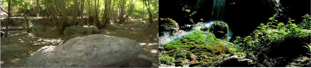
22 Ortkand River, A Geotourism Resource Geomorphologic Aspects Natural lane and lime walls from differential among vertical layer of shale and lime. Lime walls originate from vertical shale layer and natural lane. 22


23 Ortkand River, A Geotourism Resource Geologic Aspects Lime shapes in the cave erosions Collapsed old parts 23


24 Kalat Region s Geosites 24


25 Improving Tourism Infrastructures Current Restaurants Current Accommodations 25


26 Improving Tourism Infrastructures (contd.) Current Access Roads Destroyed River Bank Due to Intensive Water Streams 26

27 Solutions to Developing Geotourism Industry in Ortkand River 1. Enhancement Tourism Infrastructures; 2. Developing Access Roads; 3. Providing a Tourism Leadership Center; 4. Providing the Suitable Tourism Transfer Systems between Tourism Zones. 27


28 Proposed Approach for Developing Geotourism in Ortkand River 28
29 Economic Impacts of Geotourism Development in Ortkand River Proposed plans Expense ($) Proposed plans Expense ($) Cultural Salon for local celebration Restroom Restaurant & cafe shop Bower for local shopping Clinic Ashcan 743 Sanitary service Leadership, other facilities Levees Paving access road Flood warning system Total (in millions)
30 Benefits of Geotourism Developing Project in Ortkand Region An average tourist spend $70 during their stay. For tourists, we will have: The economic impact: Economic measure Total effect ($millions) Sales 3.5 Income 1.75 Jobs


31 Conclusion... The total expenses is about 1.4 more than total incomes earned. Investment Compensation Time is equal to 1.5 years + The Construction Period 31

32 Ortkand River
33 Thanks for your attention! 33
ECONOMIC IMPACTS OF GEOTOURISM AND GEOPARKS IN CHINA
 ECONOMIC IMPACTS OF GEOTOURISM AND GEOPARKS IN CHINA Global Eco Asia-Pacific Conference 2017, Adelaide 27-29 November, 2017 Dr Young Ng MH Geotourism Standing Committee, Geological Society of Australia
Geoheritage and History of Gold Digging in Ivalojoki River Valley, Northern Finland
 Geoheritage and History of Gold Digging in Ivalojoki River Valley, Northern Finland 4.9.2013 Peter Johansson, Geological Survey of Finland and Venla Karkola, Inari Municipal Business & Development Nordica.
Stream Geomorphology. Leslie A. Morrissey UVM July 25, 2012
 Stream Geomorphology Leslie A. Morrissey UVM July 25, 2012 What Functions do Healthy Streams Provide? Flood mitigation Water supply Water quality Sediment storage and transport Habitat Recreation Transportation
Module 10: Resources and Virginia Geology Topic 4 Content: Virginia Geology Notes
 Virginia is composed of a very diverse landscape that extends from the beaches and barrier islands all of the way to the highly elevated Appalachian Plateau. Geologists have discovered ancient shallow
CR AAO Bridge. Dead River Flood & Natural Channel Design. Mitch Koetje Water Resources Division UP District
 CR AAO Bridge Dead River Flood & Natural Channel Design Mitch Koetje Water Resources Division UP District Old County Road AAO Bridge Map courtesy of Marquette County Silver Lake Basin McClure Basin
M14/3/GEOGR/SP2/ENG/TZ0/XX/Q GEOGRAPHY STANDARD LEVEL PAPER 2. Monday 19 May 2014 (morning) 1 hour 20 minutes INSTRUCTIONS TO CANDIDATES
 1 hour 20 minutes INSTRUCTIONS TO CANDIDATES") M14/3/GEOGR/SP2/ENG/TZ0/XX/Q 22145203 GEOGRAPHY STANDARD LEVEL PAPER 2 Monday 19 May 2014 (morning) 1 hour 20 minutes INSTRUCTIONS TO CANDIDATES Do not open this examination paper until instructed to do
M14/3/GEOGR/SP2/ENG/TZ0/XX/Q 22145203 GEOGRAPHY STANDARD LEVEL PAPER 2 Monday 19 May 2014 (morning) 1 hour 20 minutes INSTRUCTIONS TO CANDIDATES Do not open this examination paper until instructed to do
Flood and Stream Restoration
 2 3 4 Pedestrian bridge under construction 3 CSPs perched on DS side Large area of sand deposition Bottom layer of gabions has been scoured out large bar of gabion stone Gabions slumping bank slope failure
Rivers and Streams. Streams. Hydrologic Cycle. Drainage Basins and Divides. Colorado River Drainage Basin. Colorado Drainage Basins.
 Chapter 14 Hydrologic Cycle Rivers and Streams Streams A stream is a body of water that is confined in a channel and moves downhill under the influence of gravity. This definition includes all sizes of
MAP. Contours: Walk before you run! Four figure grid reference: e.g. Dot is at Six figure grid reference: e.g.
 MAP Page 2 Walk before you run! Four figure grid reference: e.g. Dot is at 4665 Six figure grid reference: e.g. Dot is at 463654 Compass points for direction Contours: Measure from sea level in meters
GEOTOURISM IN LANGKAWI UNESCO GLOBAL GEOPARK
 LANGKAWI TOURISM SYMPOSIUM 2016 GEOTOURISM IN LANGKAWI UNESCO GLOBAL GEOPARK Prof. Emeritus Dato Dr. Ibrahim Komoo Council, UNESCO Global Geoparks Vice President, Asia Pacific Geoparks Network Advisor,
Sri Lanka has a coastline of km excluding the shoreline of bays and inlets.
 Defining and Demarcating Coastal zones in Sri Lanka Procedure, Challenges and What needs to be done? Dr. Anil Premaratne Director General Coast Conservation Coast Conservation Department Sri Lanka 1 Sri
Field Trip Number One. By: Pat Dryer. Geography 360
 Field Trip Number One By: Pat Dryer Geography 360 Table of Contents Introduction. Page 1 Stop One... Page 2 Stop Two... Page 4 Stop Three... Page 5 Stop Four... Page 7 Bibliography Page 8 Campus Map Source:
2017 Academic Scholarship Geography. Time allowed: 1 hour 30 minutes. Write all answers on A4 lined Paper.
 2017 Academic Scholarship 2017 Geography Time allowed: 1 hour 30 minutes Write all answers on A4 lined Paper. Also needed: 1:50 000 OS map extract of Baslow Insert to answer Section B2 Question 1 and 2
Lornshill Academy Geography Department National Revision Physical Environments Limestone
 Lornshill Academy Geography Department National Revision Physical Environments Limestone Revision Notes for Rivers What you need to know: 1. How limestone is eroded 2. Formation of features 3. How people
Hard Engineering: Lyme Regis
 Hard Engineering: Lyme Regis By The British Geographer Situation Lyme Regis, with a population of 4400 is located in the centre of the Heritage Jurassic Coast in Dorset, South England. It is exposed to
Chapter 11. Rivers: Shaping our landscape
 Chapter 11 Rivers: Shaping our landscape Learning outcomes In this presentation you will learn: Common terms associated with rivers About the three stages of a river About the processes of river erosion
How Do Human Impacts and Geomorphological Responses Vary with Spatial Scale in the Streams and Rivers of the Illinois Basin?
 How Do Human Impacts and Geomorphological Responses Vary with Spatial Scale in the Streams and Rivers of the Illinois Basin? Bruce Rhoads Department of Geography University of Illinois at Urbana-Champaign
Cambridge International Examinations Cambridge International General Certificate of Secondary Education
 Cambridge International Examinations Cambridge International General Certificate of Secondary Education *1971408231* GEOGRAPHY 0460/23 Paper 2 May/June 2016 Candidates answer on the Question Paper. Additional
Managing Floods at Boscastle. Learning Objective: Examine the benefits of managing floods
 Managing Floods at Boscastle Learning Objective: Examine the benefits of managing floods Learning Outcomes: Describe how Boscastle has been affected by flooding Explain strategies to reduce the risk Evaluate
Catastrophic Events Impact on Ecosystems
 Catastrophic Events Impact on Ecosystems Hurricanes Hurricanes An intense, rotating oceanic weather system with sustained winds of at least 74 mph and a welldefined eye Conditions for formation: Warm water
NATURE OF RIVERS B-1. Channel Function... ALLUVIAL FEATURES. ... to successfully carry sediment and water from the watershed. ...dissipate energy.
 1 2 Function... Sevier River... to successfully carry sediment and water from the watershed....dissipate energy. 3 ALLUVIAL FEATURES 4 CHANNEL DIMENSION The purpose of a stream is to carry water and sediment
Bazangan Lake a potential area for creating a geopark
 Bazangan Lake a potential area for creating a geopark Ostadi M., Abedzadeh A., Rafiei S Faculty of Science, Islamic Azad University, Sciences & Researches branch of Tehran Abstract In according to definition,
Cambridge International Examinations Cambridge International General Certificate of Secondary Education
 Cambridge International Examinations Cambridge International General Certificate of Secondary Education *9005889686* GEOGRAPHY 0460/12 Paper 1 May/June 2014 1 hour 45 minutes Candidates answer on the Question
Geopark Karavanke/Karawanken. Geo adventures in the cross- border geopark between Slovenia and Austria
 Geopark Karavanke/Karawanken Geo adventures in the cross- border geopark between Slovenia and Austria Msc. Suzana Fajmut Štrucl, Podzemlje Pece d.o.o. Msc. Mojca Bedjanič, Institute of the Republic of
Assessment. Assessment
 2001 SPRINGBROOK CREEK RESTORATION - THREE YEAR POST-CONSTRUCTION REVIEW - Presented by Bruce Henderson and Andy Harris 2005 River Restoration Northwest Symposium Skamania Lodge, Washington www.hendersonlandservices.com
UNIVERSITY OF CAMBRIDGE INTERNATIONAL EXAMINATIONS General Certificate of Education Ordinary Level
 UNIVERSITY OF CAMBRIDGE INTERNATIONAL EXAMINATIONS General Certificate of Education Ordinary Level *1795060869* GEOGRAPHY 2217/22 Paper 2 May/June 2013 Candidates answer on the Question Paper. Additional
[Leveraging & Improving Neighborhood Connections] Area E Cedar Creek
![[Leveraging & Improving Neighborhood Connections] Area E Cedar Creek](/thumbs/86/93508963.jpg "[Leveraging & Improving Neighborhood Connections] Area E Cedar Creek") Community Charrette LINC Dallas [Leveraging & Improving Neighborhood Connections] Area E Cedar Creek 06.02.12 LINC Workshop Area E Area E has the unique distinction of at-grade frontage to the Trinity
Community Charrette LINC Dallas [Leveraging & Improving Neighborhood Connections] Area E Cedar Creek 06.02.12 LINC Workshop Area E Area E has the unique distinction of at-grade frontage to the Trinity
KEY QUESTIONS KEY IDEAS SPECIFICATION CONTENT. Extreme environments are susceptible to environmental damage from the development of tourism.
 EXAM SPECIFIATION KEY QUESTIONS KEY IDEAS SPECIFICATION CONTENT AQA GCSE GEOGRAPHY A Unit 2: Human Geography Section B What is an extreme environment? What attracts tourists to Extreme environments? Extreme
If a Woodchuck Could Chuck Wood
 1/19/2018 If a Woodchuck Could Chuck Wood If a Woodchuck Could Chuck Wood The easiest way to get to the creek behind the geology museum is shown below. The red circle indicates the entrance. The yellow
Thinking Outside the Box (Culvert) Making difficult decisions for Fish Passage. Dave Stewart Oregon Department of Fish and Wildlife
 Making difficult decisions for Fish Passage. Dave Stewart Oregon Department of Fish and Wildlife") Thinking Outside the Box (Culvert) Making difficult decisions for Fish Passage Dave Stewart Oregon Department of Fish and Wildlife Overview Fish Passage History Fast Version Where are we at Now Approval
Thinking Outside the Box (Culvert) Making difficult decisions for Fish Passage Dave Stewart Oregon Department of Fish and Wildlife Overview Fish Passage History Fast Version Where are we at Now Approval
Coimisiún na Scrúduithe Stáit State Examinations Commission
 M. 24 Coimisiún na Scrúduithe Stáit State Examinations Commission LEAVING CERTIFICATE EXAMINATION 2004 GEOGRAPHY HIGHER LEVEL MONDAY, 14 JUNE, AFTERNOON 1.30 TO 4.50 Four questions to be answered, namely
Analysis of coarse sediment connectivity in semiarid river channels
 Sediment Transfer tlirongh the Fluviai System (Proceedings of a symposium held in Moscow, August 2004). IAHS Publ. 288, 2004 269 Analysis of coarse sediment connectivity in semiarid river channels J. M.
Geotourism s Contribution to Protected Areas
 Geotourism s Contribution to Protected Areas Professor Ross Dowling Edith Cowan University, Australia GlobalECO 2014 Ecotourism in Protected Areas Forum 12 November 2014 Sydney Olympic Park, Sydney Australia
Why Geomorphology for Fish Passage
 Channel Morphology - Stream Crossing Interactions An Overview Michael Love Michael Love & Associates mlove@h2odesigns.com (707) 476-8938 Why Geomorphology for Fish Passage 1. Understand the Scale of the
Sherman Falls -Virtual Field Trip-
 Sherman Falls -Virtual Field Trip- School of GEOGRAPHY & GEOLOGY Carolyn Eyles & Susan Vajoczki Prepared by Zachary Windus and Liz Kenny Directions: McMaster University to Sherman Falls From McMaster University
GCSE. Edexcel GCSE Geography A (1312 1F) Summer Mark Scheme (Results)
 Summer Mark Scheme (Results)") GCSE Edexcel GCSE Geography A (1312 1F) Summer 2006 Mark Scheme (Results) 1. (a) Look at Figure 1a. It shows population growth for Europe and Africa. (i) What was the population of Europe in 1800?...million
GCSE Edexcel GCSE Geography A (1312 1F) Summer 2006 Mark Scheme (Results) 1. (a) Look at Figure 1a. It shows population growth for Europe and Africa. (i) What was the population of Europe in 1800?...million
 12 10 8 6 4 2 0 40-50 50-60 60-70 70-80 80-90 90-100 Fresh Water What we will cover The Hydrologic Cycle River systems Floods Groundwater Caves and Karst Topography Hot springs Distribution of water in
Economic Impacts of Heritage Tourism in St. Johns County, Florida, by Tom Stevens, Alan Hodges and David Mulkey.
 Economic Impacts of Heritage Tourism in St. Johns County, Florida, 2001-02 by Tom Stevens, Alan Hodges and David Mulkey University of Florida, Institute of Food and Agricultural Sciences, Food and Resource
Working with Natural Stream Systems
 Working with Natural Stream Systems Graydon Dutcher Delaware County Soil & Water Conservation District Stream Corridor Management Program Tropical Storm Sandy October 29,2012 What is a Watershed?
Do you think sediment transport is a concern?
 STREAM RESTORATION FRAMEWORK AND SEDIMENT TRANSPORT BASICS Pete Klingeman 1 What is Your Restoration Project Like? k? Do you think sediment transport is a concern? East Fork Lewis River, WA Tidal creek,
Debris flow: categories, characteristics, hazard assessment, mitigation measures. Hariklia D. SKILODIMOU, George D. BATHRELLOS
 Debris flow: categories, characteristics, hazard assessment, mitigation measures Hariklia D. SKILODIMOU, George D. BATHRELLOS Natural hazards: physical phenomena, active in geological time capable of producing
Cambridge International Examinations Cambridge International General Certificate of Secondary Education
 Cambridge International Examinations Cambridge International General Certificate of Secondary Education *1869999605* GEOGRAPHY 0460/11 Paper 1 October/November 2017 Candidates answer on the Question Paper.
Naturally. Westport... Wet and Wild...
 Westport... Wet and Wild... Naturally A revitalization concept for the City of Westport and Port of Grays Harbor presented by FOGH (Friends of Grays Harbor), Wildlife Forever of Grays Harbor and other
Coimisiún na Scrúduithe Stáit State Examinations Commission
 S28 Coimisiún na Scrúduithe Stáit State Examinations Commission JUNIOR CERTIFICATE EXAMINATION, 2003 GEOGRAPHY - HIGHER LEVEL MONDAY, 9 th JUNE - AFTERNOON, 1.30 TO 3.30 SECTION 2 (90 MARKS) Answer THREE
Weathering, Erosion, and Deposition Guided Notes
 1. Weathering, Erosion, and Deposition 2. Outline Section 1: Weathering Section 2: Erosion Section 3: Deposition Section 4: Case Study Weathering, Erosion, and Deposition Guided Notes 3. Section 1: Weathering
Streams. Stream Water Flow
 CHAPTER 14 OUTLINE Streams: Transport to the Oceans Does not contain complete lecture notes. To be used to help organize lecture notes and home/test studies. Streams Streams are the major geological agents
Lecture Outlines PowerPoint. Chapter 5 Earth Science 11e Tarbuck/Lutgens
 Lecture Outlines PowerPoint Chapter 5 Earth Science 11e Tarbuck/Lutgens 2006 Pearson Prentice Hall This work is protected by United States copyright laws and is provided solely for the use of instructors
GCSE. Edexcel GCSE Geography A (1312 4H) Summer Mark Scheme (Results)
 Summer Mark Scheme (Results)") GCSE Edexcel GCSE Geography A (1312 4H) Summer 2006 Mark Scheme (Results) Question 1 a) Study Figure 1a. It is a sketch map of Blandford Forum. Also study Photographs A, B and C in the Map and Photography
GCSE Edexcel GCSE Geography A (1312 4H) Summer 2006 Mark Scheme (Results) Question 1 a) Study Figure 1a. It is a sketch map of Blandford Forum. Also study Photographs A, B and C in the Map and Photography
Term Knowledge Using and applying Grade Criteria Autumn 1 Assessment window October Natural hazards pose major risks to people and property.
 Assessment Schedule Year 9 2015/6 Term Knowledge Using and applying Grade Criteria Autumn 1 Assessment window October 2015 3.1.1.2 Tectonic Natural hazards pose major risks to people and property. Definition
PROMOTING NATURE CONSERVATION AND SUSTAINABLE AGRICULTURAL DEVELOPMENT IN THE RURAL AREAS OF HONG KONG
 1 PROMOTING NATURE CONSERVATION AND SUSTAINABLE AGRICULTURAL DEVELOPMENT IN THE RURAL AREAS OF HONG KONG Director of Agriculture, Fisheries and Conservation Dr. LEUNG Siu-fai A STONE S THROW AWAY FROM
Optimized positioning for accommodation centers in GIS using AHP techniques; a case study: Hamedan city
 Journal of Tourism & Hospitality Research Islamic Azad University, Garmsar Branch Vol. 2, No. 2, Autumn 2012, Pp.19-29 Optimized positioning for accommodation in GIS using AHP techniques; a case study:
M11/3/GEOGR/HP2/ENG/TZ0/XX/Q GEOGRAPHY HIGHER LEVEL PAPER 2. Friday 6 May 2011 (morning) 2 hours INSTRUCTIONS TO CANDIDATES
 2 hours INSTRUCTIONS TO CANDIDATES") M11/3/GEOGR/HP2/ENG/TZ0/XX/Q 22115202 GEOGRAPHY HIGHER LEVEL PAPER 2 Friday 6 May 2011 (morning) 2 hours INSTRUCTIONS TO CANDIDATES Do not open this examination paper until instructed to do so. Answer
M11/3/GEOGR/HP2/ENG/TZ0/XX/Q 22115202 GEOGRAPHY HIGHER LEVEL PAPER 2 Friday 6 May 2011 (morning) 2 hours INSTRUCTIONS TO CANDIDATES Do not open this examination paper until instructed to do so. Answer
Running Water Earth - Chapter 16 Stan Hatfield Southwestern Illinois College
 Running Water Earth - Chapter 16 Stan Hatfield Southwestern Illinois College Hydrologic Cycle The hydrologic cycle is a summary of the circulation of Earth s water supply. Processes involved in the hydrologic
SESSION 6: FLUVIAL LANDFORMS
 SESSION 6: FLUVIAL LANDFORMS KEY CONCEPTS: Fluvial Landforms Management of River Catchment Areas Slope Elements X-PLANATION: FLUVIAL LANDFORMS Rivers form landforms as they erode the landscape. These landforms
Edexcel GCSE Geography B: Fieldwork Ideas and Contexts for Tasks
 Edexcel GCSE Geography B: Fieldwork Ideas and Contexts for 2011-2012 Tasks This document provides a list of possible fieldwork and research ideas for the Edexcel B GCSE 2011-2012 Tasks. These are intended
Red River Levee Panel
 Red River Levee Panel Mississippi River Commission Monday, August 9, 2017 Red River Levees in LA & AR NONE along TX & OK Boarder Red River Levee Issues Caddo Levee Cherokee Park Authorization Bossier Levee
Geology Test Review Answers
 Name: Geology Test Review Answers Core: Fill in the blanks: 1. Sediments get compacted and cemented into sedimentary rock. 2. Igneous rocks can be intrusive or extrusive from a volcano. 3. Adding heat
Size matters: issues and challenges of local development with a special focus on small and medium sized towns in Czechia
 Size matters: issues and challenges of local development with a special focus on small and medium sized towns in Czechia Luděk Sýkora Charles University, Faculty of Science Dept. of Social Geography and
GEOGRAPHY 2217/12 Paper 1 October/November 2014
 www.xtremepapers.com Cambridge International Examinations Cambridge Ordinary Level * 6 7 7 2 4 1 7 0 2 4 * GEOGRAPHY 2217/12 Paper 1 October/November 2014 Candidates answer on the Question Paper. Additional
 Red River Flooding June 2015 Caddo and Bossier Parishes Presented by: Flood Technical Committee Where the Rain Falls Matters I-30 versus I-20 I-20 Backwater and Tributary Floods (Localized) 2016 Flood
The inland water related tourism in South Africa by 2030 in the light of global change
 The inland water related tourism in South Africa by 2030 in the light of global change KSA 2 Water-Linked Ecosystems T4: Green economy and sustainable (green) innovations K5/2620 How can natural capital
Primary Activities - natural vegetation - quarrying activities - agriculture / farming - dams
 (c) Human features We interpret human features on a topographic map in order to find out the activities that are carried out by people and how they are influenced by the physical environment and other
Science EOG Review: Landforms
 Mathematician Science EOG Review: Landforms Vocabulary Definition Term canyon deep, large, V- shaped valley formed by a river over millions of years of erosion; sometimes called gorges (example: Linville
Geo 302D: Age of Dinosaurs. LAB 2: Sedimentary rocks and processes
 Geo 302D: Age of Dinosaurs LAB 2: Sedimentary rocks and processes Last week we covered the basic types of rocks and the rock cycle. This lab concentrates on sedimentary rocks. Sedimentary rocks have special
Landscape evolution. An Anthropic landscape is the landscape modified by humans for their activities and life
 Landforms Landscape evolution A Natural landscape is the original landscape that exists before it is acted upon by human culture. An Anthropic landscape is the landscape modified by humans for their activities
Geotourism (Book review) Author. Published. Journal Title DOI. Copyright Statement. Downloaded from. Griffith Research Online.
 Author. Published. Journal Title DOI. Copyright Statement. Downloaded from. Griffith Research Online.") Geotourism (Book review) Author Buckley, Ralf Published 2006 Journal Title Annals of Tourism Research DOI https://doi.org/10.1016/j.annals.2005.12.004 Copyright Statement 2006 Elsevier. This is the author-manuscript
Geotourism (Book review) Author Buckley, Ralf Published 2006 Journal Title Annals of Tourism Research DOI https://doi.org/10.1016/j.annals.2005.12.004 Copyright Statement 2006 Elsevier. This is the author-manuscript
HAINING FARM DON VALLEY, VICTORIA JUNE 2017 DRAFT COMMUNITY INFORMATION
 INING FARM DON VALLEY, VICTORIA JUNE 07 COMMUNITY INFORMATION WT S PPENING? A quote about the concept for Haining Farm from the working group - Haining Farm Working Group The Haining Farm Working Group
A River Runs Through It
 A River Runs Through It Once you find the geocache, click "Found It" on the Geocaching.com app and then read and answer the questions below. Make sure to return the cache to exactly the same place you
Tourism, Communities and Sustainability under a Changing Climate: Towards Community-Based Approach in Tourism - Climate Change Nexus Studies
 Tourism, Communities and Sustainability under a Changing Climate: Towards Community-Based Approach in Tourism - Climate Change Nexus Studies Jarkko Saarinen University of Oulu, Finland Sustainable tourism
U.S. ARMY CORPS OF ENGINEERS
 CORPS FACTS Regulating Mississippi River Navigation Pools U.S. ARMY CORPS OF ENGINEERS BUILDING STRONG Historical Background Federal improvements in the interest of navigation on the Mississippi River
1. INTRODUCTION. EXAMPLE OF SECHILIENNE ROCKFALL (France)
") FORM OSE POST-GRADUATE COURSE Landslide vulnerability and risk 1 FORM OSE POST-GRADUATE COURSE Landslide vulnerability and risk 2 FORM OSE POST-GRADUATE COURSE Landslide vulnerability and risk 3 Christophe
FORM OSE POST-GRADUATE COURSE Landslide vulnerability and risk 1 FORM OSE POST-GRADUATE COURSE Landslide vulnerability and risk 2 FORM OSE POST-GRADUATE COURSE Landslide vulnerability and risk 3 Christophe
Geography Exams. RAG rate The Challenge of Natural Hazards
 Geography Exams You will sit three papers, Paper 1 will last 1 hour 30 minutes and will examine your understanding of The Challenge of Natural Hazards, The Living World and Physical Landscapes in the UK.
6.11 Naas River Management Unit
 6.11 Naas River Management Unit 6.11.1 Site 41 Issue: Bed and bank erosion Location: E 0685848 N 6058358 Waterway: Naas River Management Unit: Naas River Facing downstream from Bobeyan Rd bridge Facing
Level 1/Level 2 Certificate Specimen Paper
 Centre Number Surname Other Names Candidate Number For Examiner s Use Examiner s Initials Candidate Signature Geography 8031/1 Dynamic Physical World For this paper you must have: the colour insert (enclosed).
Griswold Creek August 22, 2013
 Creek August 22, 2013 1 Lake Erie Protection Fund Creek Study ver Evaluate the overall condition of Creek Determine stable channel dimensions & appropriate restoration techniques Starting Stat gpoint for
MATHEMATICAL MODELING OF FLUVIAL SEDIMENT DELIVERY, NEKA RIVER, IRAN. S.E. Kermani H. Golmaee M.Z. Ahmadi
 JOURNAL OF ENVIRONMENTAL HYDROLOGY The Electronic Journal of the International Association for Environmental Hydrology On the World Wide Web at http://www.hydroweb.com VOLUME 16 2008 MATHEMATICAL MODELING
Environmental Geology Chapter 9 Rivers and Flooding
 Environmental Geology Chapter 9 Rivers and Flooding Flooding in Pakistan 2010-1600 killed/20000 affected The hydrologic cycle is powered by the Sun The cycle includes evaporation, precipitation, infiltration,
Towards a Cross-Border Tourism Master Plan for the Karoo. Presentation: Peter Myles, Tournet Africa
 Towards a Cross-Border Tourism Master Plan for the Karoo Presentation: Peter Myles, Tournet Africa Definition of Sustainable Development Development that meets the needs of the present without compromising
Geodiversity, Geoheritage & Geoconservation
 Geodiversity, Geoheritage & Geoconservation Geodiversity what is its place within nature diversity? Geodiversity is the variety of nature elements, such as minerals, rocks, fossils, landforms and their
State Water Survey Division SURFACE WATER SECTION
 State Water Survey Division SURFACE WATER SECTION AT THE UNIVERSITY OF ILLINOIS Illinois Department of Energy and Natural Resources SWS Miscellaneous Publication 88 SEDIMENTATION OF POOL 19 ON THE MISSISSIPPI
16 AUGUST (Monday) Glacial Sediment
 Glacial Sediment") Presented By: U.S. Army Corps of Engineers, Detroit District Great Lakes Hydraulics and Hydrology Office With Support from the Great Lakes Commission 16 AUGUST (Monday) Glacial Sediment 9:00 9:30 Introduction
Presented By: U.S. Army Corps of Engineers, Detroit District Great Lakes Hydraulics and Hydrology Office With Support from the Great Lakes Commission 16 AUGUST (Monday) Glacial Sediment 9:00 9:30 Introduction
Essential Questions. What is erosion? What is mass wasting?
 Erosion Essential Questions What is erosion? What is mass wasting? What is Erosion? Erosion The transportation of sediment from one area to another Caused mainly by running water but also caused by glaciers,
3/3/2013. The hydro cycle water returns from the sea. All "toilet to tap." Introduction to Environmental Geology, 5e
 Introduction to Environmental Geology, 5e Running Water: summary in haiku form Edward A. Keller Chapter 9 Rivers and Flooding Lecture Presentation prepared by X. Mara Chen, Salisbury University The hydro
WATERCOURSE HARNESSING BANK EROSION AND CONSOLIDATION
 GUVERNUL MINISTERUL POSDRU MUNCII, FAMILIEI ŞI WATERCOURSE HARNESSING BANK EROSION AND CONSOLIDATION PhD. student: ALUPOAE Daniel Gheorghe Asachi Technical University of Iasi, Faculty of Civil Engineering
CASE STUDY #9 - Brushy Fork Dam, Sugar Grove, West Virginia
 CASE STUDY #9 - Brushy Fork Dam, Sugar Grove, West Virginia Brushy Fork Dam is a flood control structure built by the Soil Conservation Service southeast of the city of Franklin in Pendleton County, West
Characteristics and processes associated with the development of Hilly Landscapes
 GRADE 11 GEOGRAPHY SESSION 1: GEOMORPHOLOGY I (TOPOGRAPHY) Key Concepts In this lesson we will focus on summarising what you need to know about: Topography associated with Horizontally Layered Rocks Topography
GY 111 Lecture Note Series Sedimentary Environments 2: Rivers and Deltas
 GY 111 Lecture Notes D. Haywick (2008-09) 1 GY 111 Lecture Note Series Sedimentary Environments 2: Rivers and Deltas Lecture Goals A) Rivers and Deltas (types) B) Water Flow and sedimentation in river/deltas
Flooding in Dolgellau
 Flooding in Dolgellau Graham Hall MMath, PhD University of Wales, Bangor Background Flooding has historically been a cause for concern in Dolgellau. Following a serious flood in December 1964 when shops
Geotourism: some examples from around the world and setting an agenda for the future
 Geotourism: some examples from around the world and setting an agenda for the future Resolving the definition Some examples of geotourism: Kalbarri (self-guided geotrail) Hyden (self-guided geotrail) Undara
Earth processes are dynamic actions that occur both on
 29 Weathering, Erosion, and Deposition R EA D I N G Earth processes are dynamic actions that occur both on the earth s surface and inside the earth. Any process that breaks down earth material, such as
4.17 Spain. Catalonia
 4.17 Spain Catalonia In Spain, inundation studies are the responsibility of the respective Hydrographic Confederations of each river basin (River Basin Authorities). The actual status of inundation studies
Brief report on Belize carbonate environments field trip Feb. 2012
 Brief report on Belize carbonate environments field trip Feb. 2012 In february 2012 I travelled to San Pedro (Ambergris Caye) Belize (Figure 1) to examine and study depositional environments of carbonate
Geoparks A powerful new development vehicle for regional Australia
 Geoparks A powerful new development vehicle for regional Australia Professor Ross Dowling OAM Chair, Great South West Edge National Landscape Spotlight 7 Regional Tourism and Geotourism Thursday 27 October
Determining Absolute Age
 CHAPTER 8 SECTION 2 The Rock Record Determining Absolute Age KEY IDEAS As you read this section, keep these questions in mind: Why can t scientists use rates of erosion and deposition as the only ways
What do you need for a Marathon?
 What do you need for a Marathon? Water and a snack? What about just a normal day? 1 flush = 3.5 gallons 1 flush = 3.5 gallons 10 minute shower = 20 gal 1 flush = 3.5 gallons 10 minute shower = 20 gal Jeans
Mammoth Cave National Park, Kentucky
 Mammoth Cave National Park, Kentucky Objectives of Today s Lecture Refresher on Sedimentary Depositional Systems and Rock Classifications Transgressive and Regressive Marine Environments Carbonate Depositional
GTU. Shantilal Shah Engineering College, Bhavnagar
 GTU Shantilal Shah Engineering College, Bhavnagar 2 Around 40,000 large reservoirs worldwide used for water supply, power generation, flood control etc. About 1 % of the total storage volume is lost annually
Cultural Data in Planning and Economic Development. Chris Dwyer, RMC Research Sponsor: Rockefeller Foundation
 Cultural Data in Planning and Economic Development Chris Dwyer, RMC Research Sponsor: Rockefeller Foundation A Decade of Attempts to Quantify Arts and Culture Economic impact studies Community indicators
Project Proposal. Lyme Brook. Newcastle-under-Lyme. 3 rd July 2015
 Project Proposal Lyme Brook Newcastle-under-Lyme 3 rd July 2015 Contents Page 1.0 Introduction... 1.0 2.0 Background and rationale... 2.0 3.0 Proposed measures... 5 4.0 Summary of Recommendations... 10
Australia Malaysia 2011 Oman. Books. Journals. Contents of Presentation Geotourism an emerging opportunity for Western Australia
 Contents of Presentation Geotourism an emerging opportunity for Western Australia Ross Dowling Edith Cowan University Tourism Research Cluster Seminar Curtin University 13 May 2015 1. Definition 2. Characteristics