Cruise report of KY11-06 Leg1
|
|
|
- Emory Fletcher
- 6 years ago
- Views:
Transcription
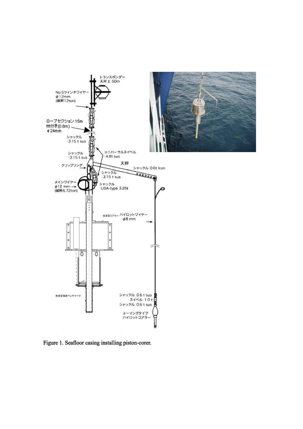
1 Cruise report of KY11-06 Leg1 Cruise : KY11-06 /Leg1 / R/V Kaiyo Research subject: Construction of Seafloor observation Network for Earthquakes and Tsunamis Research Proposal by: Yoshiyuki KANEDA/JAMSTEC Chief Scientist: Eiichiro Araki /JAMSTEC Shipboard researchers : JAMSTEC Eiichiro Araki, Hiroyuki Matsumoto NMETohru Kodera MWJHiroyuki Hayashi, Shohei Taketomo, Ei Hatakeyama, Sayaka Kawamura, Yasumi Yamada Research area : Kumano-nada Cruise period : 2011/04/10(Sun) ~ 2011/04/18(Mon) 1. Background and Overview. R/V Kaiyo departed from Yokohama Yamashita pier on Apr. 10 for off-kumano area to construct submarine cable network for Earthquakes and Tsunamis (DONET). DONET is a scientific seafloor cabled observation network for observation of earthquake and tsunamis in the epicenter area of the expected Tonankai earthquake in the Nankai Trough. The objective of the KY1106 Leg 1 cruise is to construct cased boreholes to install ocean bottom seismometers for the DONET. Ocean bottom seismographs for the DONET are installed in the borehole so that seafloor current does not interfere with the seismometer. All the boreholes were made by placing a casing in the seafloor with a tool called "Seafloor casing installing piston corer". In this cruise, total of 8 locations for borehole installation was planned. During the leg (Apr 11 to 18), Kaiyo deployed seafloor casing for ocean bottom seismographs using a seafloor casing installing piston corer for 10 times in 9 locations. After completing casing installation, Kaiyo arrived JAMSTEC headquarter pier on Apr18th to conclude the first leg of the cruise. 2. Sea floor casing installing piston corer Seafloor casing installing piston corer (Fig 1) is a tool developed by JAMSTEC for placing casing in the seafloor for making a borehole for ocean bottom seismograph installation. The tool holds a casing to form a borehole in the seafloor. The tool is lowered into the seafloor similarly to a piston corer and free fall when approached near the seafloor. When the piston corer penetrates in the seafloor, the casing can be released, and the corer is recovered.

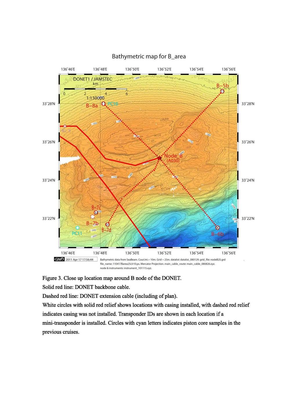
2 When the casing is released, the corer also deploys an acoustic transponder (ROV homer) in the seafloor so that ROV can find the deployed casing in the seafloor easily in the following ROVvisit to the location. When the corer penetrates in the seafloor in more than 10 degrees tilt, the casing will not be released because the ocean bottom seismographs may not be functional in such tilted borehole. The corer also obtain seafloor core sample. The core sample provides useful information such as type of seafloor material to assess seafloor environment for seismic obs ervation. Throughout the cruise, the length of suspension wire of the piston corer is chosen so that the corer free falls at 3.2 m above the seafloor (main wire length of 9.3m and pilot corer wire length of7.6m). 3. Results Total of 10 coring in 9 different locations of 7 sites was performed during the cruise. Summary of seafloor casing installation is shown in Table 1-1 and 1-2. The table describes the time and location of deployed casing, the acoustic ID of deployed transponders, whether the casing was released or not, the length and description of obtained core sample, and the tilt of the deployed casing. These locations are shown in the maps (Fig 2 to 5). The first coring at B-7 site resulted in failure in both coring and casing installation. The casing tilted after releasing it due to insufficient penetration by the gravel pumice layer. This casing is not suitable for seismometer installation. In E-20c location, the first trial was failure due to tilted casing more than 10 degrees. We retried in the same location and the second trial was successful. In some of the locations (B-7, D-15, C-11), the first shot did not penetrate casing enough to allow seismometer installation in the casing by ROV. This was mainly due to hard surface sedimentary material such as sand and pebbles. In such cases, we reconsidered the location of the casing installation for softer seafloor sediment, if we can find appropriate alternate location. Coring in level seafloor location yielded better penetration except for a site near trench (C-11b) where hard turbidity silty sand seems spread around the location. As a result of casing installations, we established 6 locations (B-7d, C-12d, D-13b, D-15d, E-19d, E-20c) suitable for seismometer installation where casing is installed with enough penetration in the seafloor. Two locations (D-15c and C-11b) have a casing installed but these are insufficient penetration. One location (B-7c) has a casing dropped in the seafloor.

3 Conclusions During the KY1106 Leg 1 cruise, we established 6 locations (B-7d, D-13b, C-12d, D-1 5d, E-1 9d, E-20c) suitable for seismometer installation where casing is installed with enough penetration in the seafloor. In the following cruises with ROV Hyper Dolphin, seismometer will be installed in these locations to start long-term seismic observation with connection to the DONET network.
4
5 Figure 2 Location map of DONET network in the Nankai Trough. Site name with squares: Seismometer to be installed, (black: casing prepared in the previous cruises, red: casing prepared during KY1106 cruise, blue: casing prepared with partial penetration).
6
7 Bathymetric map for C_area Bathymetric data from SeaBeam. Cout. lnt.= 10m. Grid = 25m. datalist: datalist_080129, grid_file: nodec50.grd. file_name: Carea50clr10.ps. Mercator Projection. main_cable_route: main_cable_ xyz. node & instruments: instrument_ xyz. Figure 4 Close up location map around C node of the DONET. Solid red line: DONET backbone cable. Dashed red line: DONET extension cable (including of plan). White circles with solid red relief shows locations with casing installed, with dashed red relief indicates casing was not installed. Transponder IDs are shown in each location if a mini-transponder is installed. Circles with blue letters indicates piston core samples in the previous cruises.

8 Bathymetric map for D_area 2011 Apr 17 18:16:42 I Bathymetric data from SeaBeam. Cout.lnt. =10m. Grid = 25m. datalist: datalist_ grid_file: noded25_ grd. file_name: 11O41ODarea25clr1O.ps. Mercator Projection. main_cable_route: main_cable_ xyz. node & instruments: instrument_ xyz. Figure 5 Close up location map around D node of the DONET. Solid red line: DONET backbone cable. Dashed red line: DONET extension cable (including of plan). Red circle (D16) is a DONET observatory operating. White circles with solid red relief shows locations with casing installed, with dashed red relief indicates casing was not installed. Transponder IDs are shown in each location if a mini-transponder is installed. Circles with blue letters indicates piston core samples in the previous cruises. Purple triangles indicate IODP observatory holes.
9 Bathymetric map for E_area Bathymetric data from SeaBeam. Cout.lnt = 10m. Grid - 25m. datalist: datalist_ gridjrle: nodee25_ grd. fi le_name: Earea25clr10.ps. Mercator Projection. main_cable_route: main_cable_ xyz. node &instruments: instrument1o1115.xyz. Figure 6 Close up location map around E node of the DONET. Solid red line: DONET backbone cable. Dashed red line and a blue line: DONET extension cable (including of plan). White circles with solid red relief shows locations with casing installed, with dashed red relief indicates casing was not installed. Transponder IDs are shown in each location if a mini-transponder is installed. Blue circle is DONET observatory (E-17) operating. Circles with blue letters indicates piston core samples in the previous cruises.
10 Table 1-1. Summary of seafloor casing installation.
11 Table 1-2. Summary of seafloor casing installation (continued)
Cruise report of R/V Kaiyo KY10-07 cruise. "Installation of Earthquake and Tsunami monitoring system"
 Cruise report of R/V Kaiyo KY10-07 cruise. "Installation of Earthquake and Tsunami monitoring system" Kumano-nada, off Shiono-misaki, the Nankai Trough Earthquake and Tsunami research project for Disaster
Real time Monitoring System for Earthquakes and Tsunamis (DONET)
") Real time Monitoring System for Earthquakes and Tsunamis (DONET) NankaiTrough Yoshiyuki Kaneda Japan Agency for Marine-Earth Science and Technology (JAMSTEC) POGO@Seoul Presentation 1 Earthquakes in the
Real time Monitoring System for Earthquakes and Tsunamis (DONET) NankaiTrough Yoshiyuki Kaneda Japan Agency for Marine-Earth Science and Technology (JAMSTEC) POGO@Seoul Presentation 1 Earthquakes in the
NT10-09 Cruise Report KUMANO-NADA DONET Node Installation & Observatory Construction
 NT10-09 Cruise Report KUMANO-NADA DONET Node Installation & Observatory Construction June 2010 Table of Contents 1. Overview 2. Schedule 3. Dive Summary 4. Concluding Remarks 1. Overview DONET is a program
Real Time Monitoring System for Megathrust Earthquakes and Tsunamis - Cabled Network System and Buoy System in Japan -
 Real Time Monitoring System for Megathrust Earthquakes and Tsunamis - Cabled Network System and Buoy System in Japan - 1 Subduction zones around the world Haiti Italy Turkey Tohoku Sichuan Taiwan Sumatra
Dense Ocean floor Network System for Earthquakes and Tsunamis DONET
 Dense Ocean floor Network System for Earthquakes and Tsunamis DONET Yoshiyuki Kaneda Japan Agency for Marine-Earth Science and Technology (JAMSTEC) ION 1 Earthquakes in the Nankai Trough Tokai Nankai Hyuga
JAMSTEC Marine Geophysical Projects for Researches on Subduction Cycles and Deformation
 JAMSTEC Marine Geophysical Projects for Researches on Subduction Cycles and Deformation Shuichi Kodaira Research Center for Earthquake and Tsunami JAMSTEC JAMSTEC Marine Geophysical Projects Motivation:
Japan Agency for Marine-Earth Science and Technology (JAMSTEC), 2-15 Natsushima-cho, Yokosuka JAPAN
, 2-15 Natsushima-cho, Yokosuka JAPAN") Dense Ocean floor Network System for Mega Thrust Earthquakes & Tsunamis(DONET) -Towards Understanding Mega Thrust Earthquakes, the Geohazard & Disaster Mitigation- Yoshiyuki KANEDA, Katsuyoshi KAWAGUCHI,
Dense Ocean floor Network System for Mega Thrust Earthquakes & Tsunamis(DONET) -Towards Understanding Mega Thrust Earthquakes, the Geohazard & Disaster Mitigation- Yoshiyuki KANEDA, Katsuyoshi KAWAGUCHI,
R/V Kairei Cruise Report KR Seismic study in Nansei-Shoto Region. November 17, 2013 December 14, 2013
 R/V Kairei Cruise Report KR13-18 Seismic study in Nansei-Shoto Region November 17, 2013 December 14, 2013 Japan Agency for Marine-Earth Science and Technology (JAMSTEC) Contents: 1.Cruise Information:
Submarine Cabled Real-time Seafloor Observatory and Subsea Engineering ROV for Observatory Construction
 Submarine Cabled Real-time Seafloor Observatory and Subsea Engineering ROV for Observatory Construction Katsuyoshi KAWAGUCHI, Sho Kaneko (Japan Agency for Marine-earth Science and Technology), Takato Nishida
R/V Kairei Cruise Report KR Seismic study in the northwestern Pacific region. Jan. 4, 2011 Jan. 20, 2011
 R/V Kairei Cruise Report KR11-01 Seismic study in the northwestern Pacific region Jan. 4, 2011 Jan. 20, 2011 Japan Agency for Marine-Earth Science and Technology (JAMSTEC) Contents: 1.Cruise Information:
KR09-08 Cruise: Walkaway VSP shooting in the Nankai Trough off Kumano
 Preliminary Report on KR09-08 Cruise: Walkaway VSP shooting in the Nankai Trough off Kumano July 19 July 25, 2009 Yokosuka - Shingu Masataka Kinoshita (IFREE-JAMSTEC) KR09-08 Shipboard Science Party Acknowledgments
Short Cruise Report R/V Maria S. Merian MSM-35T. Istanbul - Málaga Chief Scientist: Dr. Tomas Feseker Captain: Ralf Schmidt
 Dr. Tomas Feseker MARUM - Center for Marine Environmental Science and Faculty of Geosciences, University of Bremen Klagenfurter Str. Tel.: +49 421 218-6 53 48 Fax: +49 421 218-6 53 69 email: feseker@uni-bremen.de
Cruise Report YK10-06
 Cruise Report YK10-06 (R/V Yokosuka) Site Surveys for drilling projects of IODP at the Kumano-nada and the northern Izu-Bonin arc June 13 20, 2010 Center for Deep Earth Exploration (CDEX) Japan Agency
Japan Agency for Marine-Earth Science and Technology (JAMSTEC), 2-15 Natsushima-cho, Yokosuka, Kanagawa, , JAPAN
, 2-15 Natsushima-cho, Yokosuka, Kanagawa, , JAPAN") LARGE EARTHQUAKE AND ASSOCIATED PHENOMENA OBSERVED WITH SEAFLOOR CABLED OBSERVATORY NEAR EPICENTER - AN IMPLICATION FOR POSSIBLE ADDITIONAL MEASUREMENT WITH TELECOMMUNICATION NETWORKS FOR IDENTIFICATION
LARGE EARTHQUAKE AND ASSOCIATED PHENOMENA OBSERVED WITH SEAFLOOR CABLED OBSERVATORY NEAR EPICENTER - AN IMPLICATION FOR POSSIBLE ADDITIONAL MEASUREMENT WITH TELECOMMUNICATION NETWORKS FOR IDENTIFICATION
S/V Yokosuka Cruise Report YK14-E02
 S/V Yokosuka Cruise Report YK14-E02 2014FY Marine geological and geophysical surveys to unravel the subduction zone great earthquakes and tsunamis : Seismic refraction and reflection survey in the outer
We A10 12 Common Reflection Angle Migration Revealing the Complex Deformation Structure beneath Forearc Basin in the Nankai Trough
 We A10 12 Common Reflection Angle Migration Revealing the Complex Deformation Structure beneath Forearc Basin in the Nankai Trough K. Shiraishi* (JAMSTEC), M. Robb (Emerson Paradigm), K. Hosgood (Emerson
Urgent aftershock observation of the 2004 off the Kii Peninsula earthquake using ocean bottom seismometers
 LETTER Earth Planets Space, 57, 363 368, 2005 Urgent aftershock observation of the 2004 off the Kii Peninsula earthquake using ocean bottom seismometers Shin ichi Sakai 1, Tomoaki Yamada 1, Masanao Shinohara
Observation of Deep Seafloor by Autonomous Underwater Vehicle
 Observation of Deep Seafloor by Autonomous Underwater Vehicle Tamaki Ura 1 Underwater Technology Research Center Institute of Industrial Science, The University of Tokyo 4-6-1, Komaba, Minato, Tokyo, Japan
Final Report for DOEI Project: Bottom Interaction in Long Range Acoustic Propagation
 Final Report for DOEI Project: Bottom Interaction in Long Range Acoustic Propagation Ralph A. Stephen Woods Hole Oceanographic Institution 360 Woods Hole Road (MS#24) Woods Hole, MA 02543 phone: (508)
KECK REALTIME SEISMIC/GEODETIC BOREHOLE STATION. WHOI Ocean Bottom Seismograph Laboratory
 KECK REALTIME SEISMIC/GEODETIC BOREHOLE STATION WHOI Ocean Bottom Seismograph Laboratory W.M. Keck Foundation Award to Design and Construct a Real-Time Borehole Seismic and Geodetic Observatory for Deployment
Heat flow distribution on the floor of Nankai Trough off Kumano and implications for the geothermal regime of subducting sediments
 JAMSTEC Rep. Res. Dev., Volume 8, November 2008, 13 28 Original paper Heat flow distribution on the floor of Nankai Trough off Kumano and implications for the geothermal regime of subducting sediments
Observation of Deep Seafloor by Autonomous Underwater Vehicle
 Indian Journal of Geo-Marine Sciences Vol. 42 (8), December 2013,pp. 1028-1033 Observation of Deep Seafloor by Autonomous Underwater Vehicle Tamaki Ura 1 Underwater Technology Research Center, Institute
White paper for Geohazard (Submarine landslides and mass movements) at INVEST09 from Japanese research group
 at INVEST09 from Japanese research group") White paper for Geohazard (Submarine landslides and mass movements) at INVEST09 from Japanese research group A submarine landslide team of The Japanese planning group for Geohazard science at IODP* *Kiichiro
White paper for Geohazard (Submarine landslides and mass movements) at INVEST09 from Japanese research group A submarine landslide team of The Japanese planning group for Geohazard science at IODP* *Kiichiro
Seismic Activity and Crustal Deformation after the 2011 Off the Pacific Coast of Tohoku Earthquake
 J-RAPID Symposium March 6-7, 2013 Seismic Activity and Crustal Deformation after the 2011 Off the Pacific Coast of Tohoku Earthquake Y. Honkura Tokyo Institute of Technology Japan Science and Technology
MIRAI Cruise Report MR17-06
 MIRAI Cruise Report MR17-06 Geological and geophysical investigations for understanding subduction-zone earthquake and mega Tsunami: Paleoseismology in slope to trench Shimokita-oki and Hokkaido-oki Pacific
Integrated Ocean Drilling Program Expedition 316 Scientific Prospectus Addendum
 Integrated Ocean Drilling Program Expedition 316 Scientific Prospectus Addendum NanTroSEIZE Stage 1: NanTroSEIZE Shallow Megasplay and Frontal Thrusts Gaku Kimura Co-Chief Scientist Department of Earth
5.3. Ocean Bottom Seismographic Observation Eiichiro Araki, Nugroho Dwi Hananto, and Kiyoshi Suyehiro
 5.3. Ocean Bottom Seismographic Observation Eiichiro Araki, Nugroho Dwi Hananto, and Kiyoshi Suyehiro 5.3.1 Seismological background of the study area 5.3.1.1 Large historical earthquakes Both Indonesia
SEISMIC STRUCTURE, GAS-HYDRATE CONCENTRATIONS, AND SLUMPING ALONG THE IODP X311 TRANSECT ON THE N. CASCADIA MARGIN
 Proceedings of the 6th International Conference on Gas Hydrates (ICGH 2008), Vancouver, British Columbia, CANADA, July 6-10, 2008. SEISMIC STRUCTURE, GAS-HYDRATE CONCENTRATIONS, AND SLUMPING ALONG THE
SONGS Seismic Research Projects
 SONGS Seismic Research Projects Energy Division Independent Peer Review Group September 21, 2012 Agenda Background Overview Project Support Permits, Approvals, and Reviews Schedule Use of Advanced Technologies
Progressive Development of IFREE Marine Exploration Open Source Database
 JAMSTEC Report of Research and Development, Volume 3, March 2006, 9 18 Progressive Development of IFREE Marine Exploration Open Source Database Yukari Kido 1, Seiichi Miura 1, Yui Hashimoto 1, Kaoru Takizawa
Water temperature variation and thermal conductivity in the Kuroshima Knoll area, southwestern part of the Ryukyu Arc
 JAMSTEC Report of Research and Development, Volume 1, March 2005, 13 22 Water temperature variation and thermal conductivity in the Kuroshima Knoll area, southwestern part of the Ryukyu Arc Keiko Fujino*,
[S06 ] Shear Wave Resonances in Sediments on the Deep Sea Floor
![[S06 ] Shear Wave Resonances in Sediments on the Deep Sea Floor](/thumbs/82/85496146.jpg "[S06 ] Shear Wave Resonances in Sediments on the Deep Sea Floor") page 1 of 16 [S06 ] Shear Wave Resonances in Sediments on the Deep Sea Floor I. Zeldenrust * and R. A. Stephen ** * Department of Geology Free University, Amsterdam ** Department of Geology and Geophysics
page 1 of 16 [S06 ] Shear Wave Resonances in Sediments on the Deep Sea Floor I. Zeldenrust * and R. A. Stephen ** * Department of Geology Free University, Amsterdam ** Department of Geology and Geophysics
Geophysics the use of geology, laboratory & field experiments, mathematics, and instruments to study: Earthquakes and Volcanoes seismometers,
 Geophysics the use of geology, laboratory & field experiments, mathematics, and instruments to study: Earthquakes and Volcanoes seismometers, tiltmeters, EDM, remote sensing, Energy: oil, gas, hydrothermal
Ocean Bottom Seismometer Augmentation of the NPAL Philippine Sea Experiment
 DISTRIBUTION STATEMENT A. Approved for public release; distribution is unlimited. Ocean Bottom Seismometer Augmentation of the NPAL 2010-2011 Philippine Sea Experiment Ralph A. Stephen Woods Hole Oceanographic
Ship heave effects while drilling: observations from Legs 185 & 188
 Ship heave effects while drilling: observations from Legs 185 & 188 D. Goldberg 1, G. Myers 1, G. Guerin 1, D. Schroeder 2 and the Legs 185 & 188 scientific parties 1 Lamont-Doherty Earth Observatory,
Earth in 2-D, 3-D & 4-D
 Earth in 2-D, 3-D & 4-D We will consider the scientific tools and techniques used to map surface features, reconstruct the layered structure of Earth, and interpret Earth history, including the origin
Dates: February 4 February 25 - March 7, 2002 Port calls. Istanbul Limassol Limassol Chief scientist: Dr. Christian Hübscher, University Hamburg
 1 Short Cruise Report M52/2 SHORT CRUISE REPORT RV METEOR cruise M52/2 Dates: February 4 February 25 - March 7, 2002 Port calls. Istanbul Limassol Limassol Chief scientist: Dr. Christian Hübscher, University
Probing South Pacific mantle plumes with Broadband OBS
 Probing South Pacific mantle plumes with Broadband OBS BY D. SUETSUGU, H. SHIOBARA, H. SUGIOKA, G. BARRUOL. F. SCHINDELE, D. REYMOND, A. BONNEVILLE, E. DEBAYLE, T. ISSE, T. KANAZAWA, AND Y. FUKAO We conducted
Short summary of Project 1 activity during research cruise with RV Poseidon (P408-2a)
") Short summary of Project 1 activity during research cruise with RV Poseidon (P408-2a) Chief scientist: Dr. Mark Schmidt Shipboard scientific party: Dr. Peter Linke, Dr. Daniel McGinnis, Dr. Alaa Al-Barakati,
Short summary of Project 1 activity during research cruise with RV Poseidon (P408-2a) Chief scientist: Dr. Mark Schmidt Shipboard scientific party: Dr. Peter Linke, Dr. Daniel McGinnis, Dr. Alaa Al-Barakati,
A Technical Report on the Advanced Real-time Earth Monitoring Network in the Area (ARENA) Chapter 1: Preface. ver1.0. Contents
 Chapter 1: Preface. ver1.0. Contents") A Technical Report on the Advanced Real-time Earth Monitoring Network in the Area (ARENA) Chapter 1: Preface ver1.0 Contents 1.1Introduction 1.2Present state of scientific submarine cables in Japan 1.3Achievements
A Technical Report on the Advanced Real-time Earth Monitoring Network in the Area (ARENA) Chapter 1: Preface ver1.0 Contents 1.1Introduction 1.2Present state of scientific submarine cables in Japan 1.3Achievements
Introduction to future synergy options
 Deep Ocean Cabled Observatories Amsterdam, 24-25 May 2012 Introduction to future synergy options Uli Katz ECAP, Univ. Erlangen 25.05.2012 The next 20 minutes Synergy opportunities Mediterranean nodes in
NEW COMPACT OCEAN BOTTOM CABLED SYSTEM FOR SEISMIC AND TSUNAMI OBSERVATION
 NEW COMPACT OCEAN BOTTOM CABLED SYSTEM FOR SEISMIC AND TSUNAMI OBSERVATION Toshihiko Kanazawa, Masanao Shinohara, Shin'ichi Sakai, Osamu Sano, Hisashi Utada, Hajime Shiobara, Yuichi Morita, Tomoaki Yamada
Seafloor Morphology. Techniques of Investigation. Bathymetry and Sediment Studies
 Seafloor Morphology I f we select a grid for the surface of the earth (i.e. 5 km 2 ) and assign it an average elevation in relation to sea level, we can construct a graph of elevation versus area of the
Intensive seismic activity around the Nankai trough revealed by DONET ocean-floor seismic observations
 Earth Planets Space, 65, 5 15, 2013 Intensive seismic activity around the Nankai trough revealed by DONET ocean-floor seismic observations Masaru Nakano, Takeshi Nakamura, Shin ichiro Kamiya, Michihiro
MR99-K04 Cruise Summary
 MR99-K04 Cruise Summary 1. Introduction Oceanic conditions in the subtropical and subarctic gyres, especially in and around the Kurishio Extension, are thouth to be important to the North Pacific decadal/interdecadal
Redistribution of Sediments by Submarine Landslides on the Eastern Nankai Accretionary Prism
 Redistribution of Sediments by Submarine Landslides on the Eastern Nankai Accretionary Prism K. Kawamura, T. Kanamatsu, M. Kinoshita, S. Saito, T. Shibata, K. Fujino, A. Misawa, and K.C. Burmeister Abstract
Junzo KASAHARA Katsuyoshi KAWAGUCHI Ryoichi IWASE Yuichi SHIRASAKI Jun'ichi KOJIMA Tadashi NAKATSUKA
 Installation of the multi-disciplinary VENUS observatory at the Ryukyu Trench using Guam-Okinawa geophysical submarine cable (GOGC : former TPC-2 cable) Junzo KASAHARA Katsuyoshi KAWAGUCHI Ryoichi IWASE
Originally published as:
 Originally published as: Henstock, T., McNeill, L., Dean, S., Barton, P., Tilmann, F., Rietbrock, A., Robinson, D., Gulick, S., Austin, J., Djajadihardja, Y., Natawidjaja, D., Permana, H., Bonneville,
Seismicity around the seaward updip limit of the Nankai Trough seismogenic zone revealed by repeated OBS observations
 FRONTIER RESEARCH ON EARTH EVOLUTION, VOL. 1 Seismicity around the seaward updip limit of the Nankai Trough seismogenic zone revealed by repeated OBS observations Koichiro Obana 1, Shuichi Kodaira 1, Yoshiyuki
YOKOSUKA Cruise Report YK15-01
 YOKOSUKA Cruise Report YK15-01 (Nansei-shoto) Jan.7th, 2015-Jan.29th, 2015 Japan Agency for Marine-Earth Science and Technology (JAMSTEC) YK15-01 cruise report Contents 1. Cruise information 2. Participant
Preface. Japan Marine Science and Technology Center
 Japan Marine Science and Technology Center Preface JAMSTEC has greeted its th anniversary this year, the st century's very first year. The latter half of the th century, when JAMSTEC was born and grew,
The Dynamic Crust 2) 4) Which diagram represents the most probable result of these forces? 1)
 4) Which diagram represents the most probable result of these forces? 1)") 1. The diagrams below show cross sections of exposed bedrock. Which cross section shows the least evidence of crustal movement? 1) 3) 4. The diagram below represents a section of the Earth's bedrock. The
1. The diagrams below show cross sections of exposed bedrock. Which cross section shows the least evidence of crustal movement? 1) 3) 4. The diagram below represents a section of the Earth's bedrock. The
EQ Monitoring and Hazards NOTES.notebook. January 07, P-wave. S-wave. surface waves. distance
 Earthquake Monitoring and Hazards Reading a Seismogram General guidelines: P-wave First disruption of trace = Second disruption of trace = surface waves Largest disruption of trace = Not the distance to
Fluid-Rock Interactions and the Sub-Seafloor Biosphere
 Fluid-Rock Interactions and the Sub-Seafloor Biosphere BACKGROUND DATA Examples of Key Scientific Questions (OOI Science Plan) Scientific Priorities (San Juan Meeting) Example ORION Experiments (San Juan
Engineering in Support of Transformative Science
 Engineering in Support of Transformative Science Scientific Ocean Drilling of Mid-Ocean Ridge and Ridge-Flank Setting Workshop August 27, 2009 Austin, Texas Greg Myers IODP-MI Outline o Main engineering
Topic 12 Review Book Earth s Dynamic Crust and Interior
 Topic 12 Review Book Earth s Dynamic Crust and Interior Define the Vocabulary 1. asthenosphere 2. continental crust 3. Convection current 4. Convergent plate boundary 5. Divergent plate boundary 6. earthquake
Page 1. Name:
 Name: 6185-1 - Page 1 1) Which statement correctly compares seismic P-waves with seismic S-waves? A) P-waves travel faster than S-waves and pass through Earth's liquid zones. B) P-waves travel slower than
TAKE HOME EXAM 8R - Geology
 Name Period Date TAKE HOME EXAM 8R - Geology PART 1 - Multiple Choice 1. A volcanic cone made up of alternating layers of lava and rock particles is a cone. a. cinder b. lava c. shield d. composite 2.
Intraoceanic thrusts in the Nankai Trough off the Kii Peninsula: Implications for intraplate earthquakes
 Click Here for Full Article GEOPHYSICAL RESEARCH LETTERS, VOL. 36, L06303, doi:10.1029/2008gl036974, 2009 Intraoceanic thrusts in the Nankai Trough off the Kii Peninsula: Implications for intraplate earthquakes
RISKY HIGH-RISE BUILDINGS RESONATING WITH THE LONG-PERIOD STRONG GROUND MOTIONS IN THE OSAKA BASIN, JAPAN
 RISKY HIGH-RISE BUILDINGS RESONATING WITH THE LONG-PERIOD STRONG GROUND MOTIONS IN THE OSAKA BASIN, JAPAN K. Miyakoshi 1 and M. Horike 2 ABSTRACT : 1 Earthquake Engineering Group, Geo-Research Institute,
Name Midterm Review Earth Science Constructed Response
 Name Midterm Review Earth Science Constructed Response Base your answers to questions 1 and 2 on the world map below. Points A through H represent locations on Earth's surface. 1. Identify the tectonic
Seismic study in the Sagami Bay (Multichannel seismic reflection survey)
") KR10-01 Cruise Report Seismic study in the Sagami Bay (Multichannel seismic reflection survey) Jan. 4, 2010 Jan. 8, 2010 Japan Agency for Marine-Earth Science and Technology (JAMSTEC) -1 - Contents: 1.
KR10-01 Cruise Report Seismic study in the Sagami Bay (Multichannel seismic reflection survey) Jan. 4, 2010 Jan. 8, 2010 Japan Agency for Marine-Earth Science and Technology (JAMSTEC) -1 - Contents: 1.
I point out two possible paradoxical difficulties in the important target of the IODP in subduction zones, i.e.,
 Drilling the Seismogenic Zone: Some Paradoxes Tetsuzo Seno Earthquake Research Institute, University of Tokyo (Bull. Earthq. Res. Inst., subumitted on January 16, 2003; accepted on July 22, 2003) Abstract
Bathymetry Measures the vertical distance from the ocean surface to mountains, valleys, plains, and other sea floor features
 1 2 3 4 5 6 7 8 9 10 11 CHAPTER 3 Marine Provinces Chapter Overview The study of bathymetry determines ocean depths and ocean floor topography. Echo sounding and satellites are efficient bathymetric tools.
Differentiating earthquake tsunamis from other sources; how do we tell the difference?
 Differentiating earthquake tsunamis from other sources; how do we tell the difference? David Tappin (1), Stephan Grilli (2), Jeffrey Harris (2), Timothy Masterlark (3), James Kirby (4), Fengyan Shi Shi
34. THE GEOLOGICAL AND GEOPHYSICAL SETTING NEAR SITE 462 1
 34. THE GEOLOGICAL AND GEOPHYSICAL SETTING NEAR SITE 462 L. K. Wipperman, 2 Hawaii Institute of Geophysics, University of Hawaii, Honolulu, Hawaii R. L. Larson, 3 Lamont-Doherty Geological Observatory
THEORETICAL EVALUATION OF EFFECTS OF SEA ON SEISMIC GROUND MOTION
 13 th World Conference on Earthquake Engineering Vancouver, B.C., Canada August 1-6, 2004 Paper No. 3229 THEORETICAL EVALUATION OF EFFECTS OF SEA ON SEISMIC GROUND MOTION Ken HATAYAMA 1 SUMMARY I evaluated
Double-difference relocations of the 2004 off the Kii peninsula earthquakes
 LETTER Earth Planets Space, 57, 357 362, 25 Double-difference relocations of the 24 off the Kii peninsula earthquakes Bogdan Enescu 1, James Mori 1, and Shiro Ohmi 1 1 Disaster Prevention Research Institute
Our knowledge of the physical characteristics
 This map shows 20 regions for locating seafloor seismic observatories in order to have 128 stations evenly spaced around the globe (red boxes). The six starred boxes have been selected as preliminary test
Which lettered location has the highest elevation? A) A B) B C) C D) D
 A B) B C) C D) D") 1. New York State's highest peak, Mt. Marcy, is located at approximately A) 44 10' N 74 05' W B) 44 05' N 73 55' W C) 73 55' N 44 10' W D) 74 05' N 44 05' W 2. Four locations, A, B, C, and D, are represented
1. New York State's highest peak, Mt. Marcy, is located at approximately A) 44 10' N 74 05' W B) 44 05' N 73 55' W C) 73 55' N 44 10' W D) 74 05' N 44 05' W 2. Four locations, A, B, C, and D, are represented
Chapter Overview. Bathymetry. Measuring Bathymetry. Measuring Bathymetry
 CHAPTER 3 Marine Provinces Chapter Overview The study of bathymetry determines ocean depths and ocean floor topography. Echo sounding and satellites are efficient bathymetric tools. Most ocean floor features
Section 19.1: Forces Within Earth Section 19.2: Seismic Waves and Earth s Interior Section 19.3: Measuring and Locating.
 CH Earthquakes Section 19.1: Forces Within Earth Section 19.2: Seismic Waves and Earth s Interior Section 19.3: Measuring and Locating Earthquakes Section 19.4: Earthquakes and Society Section 19.1 Forces
Short Cruise Report R/V MARIA S. MERIAN MSM34/2
 Dr. Joerg Bialas GEOMAR Helmholtz-Centre fpr Marine Sciences Kiel Wischhofstr. 1-3 24148 Kiel Tel.: +49 (0)431 600 2329 Fax: +49 (0)431 600 2922 email: jbialals@geomar.de Short Cruise Report R/V MARIA
Unit Topics. Topic 1: Earth s Interior Topic 2: Continental Drift Topic 3: Crustal Activity Topic 4: Crustal Boundaries Topic 5: Earthquakes
 The Dynamic Earth Unit Topics Topic 1: Earth s Interior Topic 2: Continental Drift Topic 3: Crustal Activity Topic 4: Crustal Boundaries Topic 5: Earthquakes Topic 1: Earth s Interior Essential Question:
Accumulation of an earthquake-induced extremely turbid layer in a terminal basin of the Nankai accretionary prism
 Ashi et al. Earth, Planets and Space 214, 66:51 LETTER Open Access Accumulation of an earthquake-induced extremely turbid layer in a terminal basin of the Nankai accretionary prism Juichiro Ashi 1*, Ritsuko
Earth s Continents and Seafloors. GEOL100 Physical Geology Ray Rector - Instructor
 Earth s Continents and Seafloors GEOL100 Physical Geology Ray Rector - Instructor OCEAN BASINS and CONTINENTAL PLATFORMS Key Concepts I. Earth s rocky surface covered by of two types of crust Dense, thin,
What is the role of the Nankai Frontal prism in tsunamigenic earthquakes & slow slip?
 What is the role of the Nankai Frontal prism in tsunamigenic earthquakes & slow slip? A Core-Log-Seismic Integration Investigation at Sea: Synthesis and New Directions in research building on NanTroSEIZE
Crustal deformation by the Southeast-off Kii Peninsula Earthquake
 Crustal deformation by the Southeast-off Kii Peninsula Earthquake 51 Crustal deformation by the Southeast-off Kii Peninsula Earthquake Tetsuro IMAKIIRE, Shinzaburo OZAWA, Hiroshi YARAI, Takuya NISHIMURA
Recent Progress of Seismic Observation Networks in Japan
 Journal of Physics: Conference Series Recent Progress of Seismic Observation Networks in Japan To cite this article: Y Okada 2013 J. Phys.: Conf. Ser. 433 012039 Related content - Physical applications
Natsushima Cruise Report NT13-02
 Natsushima Cruise Report NT13-02 Tsunami Prediction system: Research Cruise in Japan Trench: Piston Coring (Off Tohoku) Jan.21th, 2013-Feb.9th, 2013 Japan Agency for Marine-Earth Science and Technology
Earthquake,Tsunami,Volcano Monitoring & Warning System in Korea. Jimin Lee Earthquake & Volcano Monitoring Division KMA
 Earthquake,Tsunami,Volcano Monitoring & Warning System in Korea Jimin Lee Earthquake & Volcano Monitoring Division KMA 1 2 Brief History & Vision of KMA Introduction of Services 3 Korea National Seismographic
Yev Kontar. Illinois State Geological Survey, University of Illinois at Urbana-Champaign
 Addressing Caribbean Geophysical Hazards through the Continuously Operating Caribbean GPS Observational Network (COCONet) and International Ocean Drilling Program (IODP) Yev Kontar Illinois State Geological
Slide 1. Earth Science. Chapter 5 Earthquakes
 Slide 1 Earth Science Chapter 5 Earthquakes Slide 2 Forces in Earth's Crust A force that acts on rock to change its shape or volume is stress 3 types of stress acting on rock layers Tension pulls on the
IODP Nankai Trough Seismogenic Zone Experiment Stage 1 Expedition 316 "Shallow Megasplay and Frontal Thrusts" on the Chikyu
 1 IODP Nankai Trough Seismogenic Zone Experiment Stage 1 Expedition 316 "Shallow Megasplay and Frontal Thrusts" on the Chikyu The D/V Chikyu was delivered in July 2005. The ship is much larger than the
Marine environment monitoring : The basic requirements to support Marine Renewable Energies
 Marine environment monitoring : The basic requirements to support Marine Renewable Energies SHOM in brief SHOM is the French Government agency in charge of Hydrography and Oceanography SHOM s vocation
Project AHOLO: A Hawaiian Ocean Landslide Observatory
 Project AHOLO: A Hawaiian Ocean Landslide Observatory R/V Kilo Moana Southeast Flank, Kilauea Volcano, Hawai i Leg 1: Deployment October 15-22, 2005 CRUISE PARTICIPANTS Science Party: Benjamin Brooks (University
Dr. Mark Leckie Scientist
 Wanted: Dead and Well-Preserved... Mohawk Guy and his Band of Neogene Planktic Foraminifer Friends Dr. Mark Leckie Scientist Introduction Dr. Mark Leckie has a passion for science and education with a
REPORT ON THE TOHOKU AREA PASIFIC OFFSHORE EARTHQUAKE
 REPORT ON THE TOHOKU AREA PASIFIC OFFSHORE EARTHQUAKE GENERAL PERSPECTIVE The Highest Magnitude Ever Recorded The 2011 off the Pacific Coast of Tohoku Earthquake (hereafter, the 2011 Tohoku- Pacific Earthquake
Map shows 3 main features of ocean floor
 Map shows 3 main features of ocean floor 2017 Pearson Education, Inc. Chapter 3 Marine Provinces 2017 Pearson Education, Inc. 1 Chapter 3 Overview The study of bathymetry determines ocean depths and ocean
Oceanography. Oceanography is the study of the deep sea and shallow coastal oceans.
 Oceanography Oceanography is the study of the deep sea and shallow coastal oceans. Studying the Ocean Floor To determine the shape and composition of the ocean floor, scientists use techniques such as
Aftershock distribution of the 26 December 2004 Sumatra-Andaman earthquake from ocean bottom seismographic observation
 Earth Planets Space, 58, 113 119, 2006 Aftershock distribution of the 26 December 2004 Sumatra-Andaman earthquake from ocean bottom seismographic observation Eiichiro Araki 1, Masanao Shinohara 2, Koichiro
YOKOSUKA Cruise Report YK Evaluation cruise for hybrid submersible gravity. observation system for exploration
 YOKOSUKA Cruise Report YK13-13 Evaluation cruise for hybrid submersible gravity observation system for exploration Izena Caldera in the middle Okinawa trough Dec. 6, 2013 - Dec. 14, 2013 Japan Agency for
Shiptrack of Cruise MSM20-5 to and from our work area "North Pond"
 Wolfgang Bach Institute for Geosciences University of Bremen Klagenfurter Str. 28359 Bremen Tel.: +49 421 218 65400 Fax: +49 421 218 65429 e-mail: wbach@uni-bremen.de Short Cruise Report RV MARIA S: MERIAN
Earthquake Early Warning in Subduction Zones
 Earthquake Early Warning in Subduction Zones Jeffrey J. McGuire 1, Frederik J. Simons 2, and John A. Collins 1 1 Department of Geology and Geophysics, Woods Hole Oceanographic Institution 2 Geosciences
Tatsuhiko Sakamoto 1a*, Saiko Sugisaki 1a,2, Koichi Iijima 1a
 JAMSTEC-R IFREE Special Issue, November 2009 Marine sediment coring in the dark side: a method of complete optical covered sampling onboard for the optically stimulated luminescence dating of deep sea-bottom
Gulf of Cadiz: Integrated observations from nearshore sources of tsunamis: Towards an early warning system NEAREST
 Gulf of Cadiz: Integrated observations from nearshore sources of tsunamis: Towards an early warning system NEAREST EC Project FP6, 2006-2009 (Contr. no. 037110) E. Gràcia (1), N. Zitellini (2), J.J. Dañobeitia
Forces in Earth s Crust
 Name Date Class Earthquakes Section Summary Forces in Earth s Crust Guide for Reading How does stress in the crust change Earth s surface? Where are faults usually found, and why do they form? What land
ACTIVITIES OF THE HEADQUARTERS FOR EARTHQUAKE RESEARCH PROMOTION
 Journal of Japan Association for Earthquake Engineering, Vol.4, No.3 (Special Issue), 2004 ACTIVITIES OF THE HEADQUARTERS FOR EARTHQUAKE RESEARCH PROMOTION Sadanori HIGASHI 1 1 Member of JAEE, Earthquake
GSA DATA REPOSITORY
 1 GSA DATA REPOSITORY 2010282 Bangs et al. Supplemental Material Bottom Water Currents and Seafloor Erosion as a Triggering Mechanism The nearest bottom current measurements were made ~ 60 km to the east
Promoting Seafloor Observation in China -- A Meeting Report
 Promoting Seafloor Observation in -- A Meeting Report Introduction With its rapid development in economy, is now placing more emphasis on marine science and technology. Recently, construction of a sea-floor