Cruise report of R/V Kaiyo KY10-07 cruise. "Installation of Earthquake and Tsunami monitoring system"
|
|
|
- Ernest Dalton
- 5 years ago
- Views:
Transcription
1 Cruise report of R/V Kaiyo KY10-07 cruise. "Installation of Earthquake and Tsunami monitoring system" Kumano-nada, off Shiono-misaki, the Nankai Trough Earthquake and Tsunami research project for Disaster Prevention, JAMSTEC
2 Table of contents 1. Cruise Summary information 2. Background and Objectives 3. Methods 4. Operation and results 5. Conclusions
3 1. Cruise summary information Research Theme: Construction and improvement of Seafloor observation Network for Earthquakes and Tsunamis Research proposal by: Yoshiyuki KANEDA (JAMSTEC) Chief scientist: Eiichiro Araki(JAMSTEC) Shipboard researchers: Eiichiro Araki, Takashi Yokobiki, Hiroyuki Matsumoto, Shinichiro Kamiya (JAMSTEC) Akira Soh, Yuuki Miyazima, Hiroyuki Hayashi, Naohito Mori, Asuka Kawamura (MWJ) Toru Kodera, Hiroyasu Momma (NME). Research area: Kumano-nada Cruise period: May 1/2010 (Yokosuka JAMSTEC) Leg 1- May 9/2010 (Shingu) - Leg2 - May 18/2010 (Yokosuka JAMSTEC)
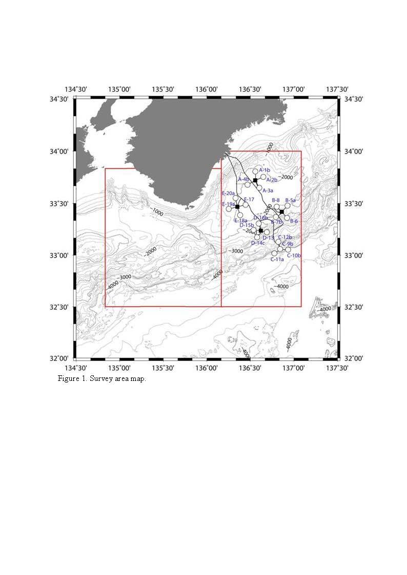
4 2. Background and Objectives Research project of earthquake and tsunami, disaster prevention, JAMSTEC has been conducting development of monitoring system for earthquake and tsunamis since 2006 under a contracted research program from MEXT, Development of monitoring system of earthquake and tsunami. The development consists from development of network system that can deploy seismometers and tsunami sensors densely in offshore Kii Peninsula (Figure 1), where large earthquake occurs in an interval of years. We developed a network system consisting from a backbone cable, nodes, sensors, and extension cables. The backbone cable is a loop of approximately 250 km fiber optic cable both ends landed at land station in Furue-cho, Owase-city of Mie prefecture. The backbone cable has five termination units where we can connect a node that distributes power and data communication to sensors Searfloor sensors, 20 of which are distributed in and around the rupture zone of Tonankai Earthquake offshore Kii Peninsula, are connected to the backbone cable via a node, which distributes power and data to each seafloor sensors. The sensors, consists from a set of seismometers, pressure gauges, and a thermometer. Seismometers are buried in the seabed to improve its coupling to the ground motion and escape from influences caused by seafloor water motion. The backbone cable was laid out by a commercial cable laying ship in January to March, Installation of nodes and sensors are conducted by JAMSTEC s R/V Natsushima with remotely operated vehicle (ROV) Hyper Dolphin. Seismic sensors are buried into the seabed. We need to have a shallow hole in the seafloor to bury the seismic sensor by ROV. Perforating seafloor shallow hole is planned by two steps, installing a caisson with a root using piston corer, and sweeping mud which is enclosed in the caisson using a hydraulic pump with ROV Hyper Dolphin. The purpose of this cruise is to conduct the former half operations to perforate seafloor hole; installation of caissons using piston corer. Another objective of this cruise was to survey the seafloor by a camera to clear the route for cable extension. This was necessary to assure safe cable extension operation by ROV to connect seafloor sensors and the node. The survey was performed during the latter half of the cruise using JAMSTEC Deep Tow camera with a towing system to recover or cut obstacle such as a rope when encountered.
5
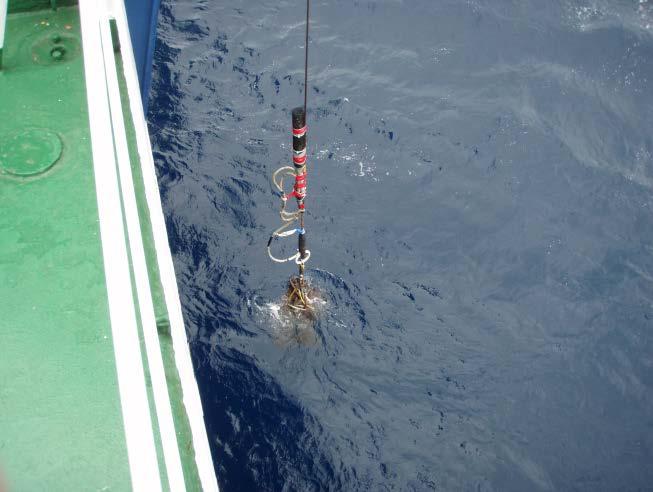
6 3. Methods 3.1 Seafloor casing installation by gravity corer. Perforation of seafloor and installation of seafloor casing for seismometer installation was performed by a gravity corer which can release a caisson attached to the end of corer. Figure 2 illustrates the gravity corer we used. The corer is lowered to the seafloor using #5 winch of R/V Kaiyo. When approached near the seafloor, after checking location using SSBL of the position of the corer from acoustic transponder located 50 m above the corer, the corer is further lowered to the seafloor until the pilot corer touch the seafloor and the corer weight and caisson free fall to penetrate seafloor. Penetration status of seafloor casing is confirmed by seafloor sensor and tiltmeter. Status of these sensors can be monitored by the response of the acoustic release transponder when called. Acoustic command to the acoustic release from R/V Kaiyo releases the casing while the inner pipe and core sample is recovered with the corer.

7 Figure 2. Casing installing piston corer.
8 3.2 Deep tow survey Deep Tow survey used 6000m class Deep tow camera system to survey seafloor along the planned cable route between the science node of DONET and planned observatories. We prepared a towing system shown as Figure 3 to capture obstacle between the seafloor and the deep tow frame. The Deep tow camera system also equipped a ROV Homer acoustic transponder to measure distance to the ROV homer acoustic mini-transponder attached to the terminal unit of the DONET cable deployed by cable ship prior to the cruise. Figure 3. Towing system plan
9 4. Operation and results 4.1 Seafloor casing installation by gravity corer. Seafloor casing installation using gravity corer in areas of Node A through E were attempted from May 2 to May 8. Two coring were attempted each day except for May 3rd. Operation of casing installation is summarized in Table 1, showing time of each attempt, location of the corer by transponder location from SSBL acoustic navigation, and tilt of installed casing, and the results of coring including if we released the casing. Some of the attempts failed. There are various reasons of the failure, such because of unbalance of the corer system, insufficient penetration due to stiff seafloor. We analyzed the cause of the failure from response of acoustic transponder indicating tilt and penetration, tilt information given from tiltmeter and accelerometer attached to the corer, contents of cored sample. In the case that unbalance of the corer was found from the tiltmeter record, we tried to adjust the balance using counter weight and it was confirmed by the next coring attempt. At sites, D-15b, C-12b, E-20b, C-11a, and C10b, coring results were problematic with stiff seabed condition, and further coring operation was considered necessary in the following cruises. Overall, 9 useful casing installation was performed out of 15 coring trial and 11 releases. Poi nt I D ROV shot posi t i on f r om acoust i c Shot t i me( JST) Rel ease Ho me r ID Lati tude Longi t ude Dept h 01 B /05/02 09: 26 Yes ' N ' E 1, m 02 B-7b /05/02 14: 14 No ' N ' E 2, m 03 B-7b /05/03 07: 35 Yes ' N ' E 2, m 04 D-16b /05/03 11: 40 Yes ' N ' E 1, m 05 D-15b /05/03 15: 07 No ' N ' E 1, m 06 D-14c /05/04 08: 03 Yes ' N ' E 2, m 07 D /05/04 12: 03 Yes ' N ' E 2, m 08 B-5a /05/05 08: 18 Yes ' N ' E 1, m 09 B /05/05 11: 47 Yes ' N ' E 2, m 10 C-12b /05/06 08: 25 Yes ' N ' E 3, m 11 C-9c /05/06 13: 14 Yes ' N ' E 3, m 12 E-20b /05/07 07: 47 No ' N ' E 1, m 13 A-1c /05/07 14: 10 Yes ' N ' E 1, m 14 C-11a /05/08 09: 12 No ' N ' E 4, m 15 C-10b /05/08 14: 22 Yes ' N ' E 4, m Pi st on cor er set t i ng: f r ee f al l 3. 2m and ext ended mai n wi r e l engt h 3. 3m mai n wi r e l engt h = 9. 3m except f or #8 and #13 = 10. 3m pi l ot wi r e l engt h = 7. 6m except f or #8 and #13 = 8. 6m Table 1. Casing installation operation summary. ID of the ROV homer attached in each casing, time and location of coring, as well as whether casing was released, are shown.
10 Poi nt I D Corer ti l t cor i ng r esul t X( ) Y( ) Sa mp l e I DPenet r at i o Pi st on Pilot Remar ks 01 B PC m m m 02 B-7b PC m m m br oken casi ng when r ecover ed 03 B-7b PC m m m 04 D-16b - - PC m m m 05 D-15b PC m m m br oken casi ng when r ecover ed, t i l t af t er l andi ng. 06 D-14c PC m m m 07 D PC m m m 08 B-5a PC m m m casi ng l engt h 2. 5m 09 B PC m m m 10 C-12b PC m m m tilt after landing. 11 C-9c PC m m m 12 E-20b PC m m br oken casi ng when r ecover ed, ROV homer not m r ecover ed. 13 A-1c PC m m m casi ng l engt h 2. 5m 14 C-11a PC m m br oken casi ng when r ecover ed, ROV homer f l ooded, no m t i l t met er at t ached 15 C-10b PC m m no t i l t met er at t ached Table 2. Casing installation operation summary (continued). Corer tilt angle after penetration and coring penetration length are shown Deep-Tow Survey We carried out camera survey by using Deep Tow system during the KY10-07cruise as follows (summary in Table 3). Shaded route survey (DT-4C and DT-5C) indicate the route clearance to remove obstacle. Detailed survey results are given from the next page. Start End FreeFall 32_40'0 135_55.0' DT-1C Node_Aa -> A-2b 33_ _ _ _ DT-2C E-17 -> Node_E 33_ _ _ _ DT-3C A-4b -> Node_Aa 33_ _ _ _ DT-4C A-4b area 33_ _ DT-5C A-4b area 33_40.68' 136_27.36' 33_40.88' 136_ _40.80' 136_27.76' 33_40.60' 136_ _40.52' 136_27.52' 33_40.72' 136_27.84' 33_40.56' 136_28.00' 33_40.36' 136_27.68' 33_40.28' 136_27.76' 33_40.48' 136_ _40.40' 136_ _40.20' 136_27.84 DT-6C 33_40.677' 136_28.037' 33_43.349' 136_33.215' DT-7C 33_13.920' 136_37.270' 33_14.238' 136_37.232' Table3. Summary of the camera survey


11 4.2.1 Free Fall(2010/05/10) Point: 32_40.0 N, 135_55.0 E D=4,620 m Transponder KAIYO track Point
12 4.2.2 Route Survey (1) DT-1C(2010/05/11) (Node_Aa -> A-2b) Start: 33_ N, 136_ E D=2,009 m ROV-Homer ID: 23 End: 33_ N, 136_ E D=2,013 m ROV-Homer ID: 92 A-2b DT-1C アイドルケーブル A-2b Node_Aa Node_Aa 給電岐路ケーブル給電岐路ケーブル 展張ケーブル 給電岐路ケーブル 展張ケーブル DT-1C track Plan DeepTow track
13 (2) DT-2C(2010/05/12) (E-17 -> Node_E) Start: 33_ N, 136_ E D=2,056 m ROV-Homer ID: 98 End: 33_ N, 136_ E D=1,968 m ROV-Homer ID: 27 給電岐路ケーブル給電岐路ケーブル 基幹ケーブル基幹ケーブル E-17 海底ケーブル視認 ROV-Homer 200m 給電岐路ケーブル 基幹ケーブル E-17 Node_E DT-2C Node_E アイドルケーブル 海底ケーブル視認 ROV-Homer 45m DT-2C track Plan DeepTow track
14 (3) DT-3C(2010/05/13) (A-4b -> Node_Aa) Start: 33_ N, 136_ E D=2,056 m ROV-Homer ID: 24 End: 33_ N, 136_ E D=2,009 m ROV-Homer ID: 23 DT-3C 航跡図 基幹ケーブル Node_Aa 展張ケーブル 給電岐路ケーブル DT 挙動異常 N, E A-4b DT-3C 張力急低下深度 1124m N, E Plan DeepTow track
15 (4) DT-4C(2010/05/14) (A-4b area clearence) Target: 33_ N, 136_ E D=2,054 m A-4b: 33_ N, 136_ E D=2,056 m ROV-Homer ID: 23 DT-4C 航跡図 A-4b DT 挙動異常 DT 拘束 DT-3C 開始 DT 張力低下 Plan DeepTow track
16 (5) DT-5C(2010/05/15) (A-4b area clearence) Line Lat.N Lon.E Lat.N Lon.E L1 P P L2 P P L3 P P L4 P P L5 P P L6 P P DT-5C 測線 ( 案 ) DT-4C & DT-5C 航跡図 P2 L1 P4 L2 P6 P1 L3 P3 P8 P5 L4 P10 L5 P12 P7 L6 P9 P11 DT-4C track DT-5C track A-4b DT-3C 拘束 DT-3C 開始 DT-3C 張力低下 Plan DeepTow track
17 (6) DT-6C(2010/05/16) (A-4b -> Node_Aa) Start: 33_ N, 136_ E D=2,056 m ROV-Homer ID: 24 End: 33_ N, 136_ E D=2,009 m ROV-Homer ID: 23 基幹ケーブル Node_Aa 基幹ケーブル基幹ケーブル Node_Aa 展張ケーブル展張ケーブル アイドルケーブル Node_Aa 給電岐路ケーブル給電岐路ケーブル 展張ケーブル 給電岐路ケーブル A-4b DT-6C A-4b 海底ケーブル視認 DT-4C track DT-5C track DT-6C track Plan DeepTow track
18 (7) DT-7C(2010/05/17) (Node_Db search) Start: 33_ N, 136_ E D=2,057 m End: 33_ N, 136_ E D=2,076 m 給電岐路ケーブル給電岐路ケーブルアイドルケーブルアイドルケーブル Node_Db 海底ケーブル視認 アイドルケーブルアイドルケーブル給電岐路ケーブル P2 Node_Db L2 P4 ROV-Homer 27m P3 P1 L1 DT-7C track KAIYO track Plan DeepTow track
19 5. Conclusions During KY10-07 cruise, we conducted 15 piston coring operation to install seafloor casing for seismic sensor installation in the Kumano area of the Nankai Trough. Among 15 coring attempts, 12 shots released the casing in the seafloor and 9 of the released casing penetrated in the seabed enough for seismic sensor installation. These installed seafloor casings will be utilized to house buried ocean bottom seismic sensor for DONET. Latter half leg of KY10-07 cruise conducted seafloor camera survey using "Deep-Tow" system of JAMSTEC. After free-fall cable maintenance, 7 survey was conducted to clear cable routes in Node-A and Node-E areas as well as to find the exact location of the backbone cable route after installation by cable ship.. Three route clearances, i.e., for A-2, A-4, and E-17 observatories have been completed during the present KY10-07 cruise. It should be noted that Deep-Tow seemed to be captured by something in the deep sea westward at A-4 observatory but out of science link cable route. We tried to remove the obstacle by two dives (DT-4C and DT-5C dives), but we could not finished yet. During the KY10-07 cruise, we also checked the location of two terminal units (TU_D and TU_E) by using acoustic instrument (ROV-Homer system). This is because all TUs of DONET have been deployed from the cable ship with no positioning system, we have to look for TUs at first in order for deployment of science node by ROV dive. We plan to establish 20 observatories in total by this fiscal year. We have checked no problems for ROV dive and its operation for A-2, A-4, and E-17 observatories at least after the present KY10-07 cruise.
Cruise report of KY11-06 Leg1
 Cruise report of KY11-06 Leg1 Cruise : KY11-06 /Leg1 / R/V Kaiyo Research subject: Construction of Seafloor observation Network for Earthquakes and Tsunamis Research Proposal by: Yoshiyuki KANEDA/JAMSTEC
NT10-09 Cruise Report KUMANO-NADA DONET Node Installation & Observatory Construction
 NT10-09 Cruise Report KUMANO-NADA DONET Node Installation & Observatory Construction June 2010 Table of Contents 1. Overview 2. Schedule 3. Dive Summary 4. Concluding Remarks 1. Overview DONET is a program
Real time Monitoring System for Earthquakes and Tsunamis (DONET)
") Real time Monitoring System for Earthquakes and Tsunamis (DONET) NankaiTrough Yoshiyuki Kaneda Japan Agency for Marine-Earth Science and Technology (JAMSTEC) POGO@Seoul Presentation 1 Earthquakes in the
Real time Monitoring System for Earthquakes and Tsunamis (DONET) NankaiTrough Yoshiyuki Kaneda Japan Agency for Marine-Earth Science and Technology (JAMSTEC) POGO@Seoul Presentation 1 Earthquakes in the
Dense Ocean floor Network System for Earthquakes and Tsunamis DONET
 Dense Ocean floor Network System for Earthquakes and Tsunamis DONET Yoshiyuki Kaneda Japan Agency for Marine-Earth Science and Technology (JAMSTEC) ION 1 Earthquakes in the Nankai Trough Tokai Nankai Hyuga
Real Time Monitoring System for Megathrust Earthquakes and Tsunamis - Cabled Network System and Buoy System in Japan -
 Real Time Monitoring System for Megathrust Earthquakes and Tsunamis - Cabled Network System and Buoy System in Japan - 1 Subduction zones around the world Haiti Italy Turkey Tohoku Sichuan Taiwan Sumatra
Japan Agency for Marine-Earth Science and Technology (JAMSTEC), 2-15 Natsushima-cho, Yokosuka JAPAN
, 2-15 Natsushima-cho, Yokosuka JAPAN") Dense Ocean floor Network System for Mega Thrust Earthquakes & Tsunamis(DONET) -Towards Understanding Mega Thrust Earthquakes, the Geohazard & Disaster Mitigation- Yoshiyuki KANEDA, Katsuyoshi KAWAGUCHI,
Dense Ocean floor Network System for Mega Thrust Earthquakes & Tsunamis(DONET) -Towards Understanding Mega Thrust Earthquakes, the Geohazard & Disaster Mitigation- Yoshiyuki KANEDA, Katsuyoshi KAWAGUCHI,
Submarine Cabled Real-time Seafloor Observatory and Subsea Engineering ROV for Observatory Construction
 Submarine Cabled Real-time Seafloor Observatory and Subsea Engineering ROV for Observatory Construction Katsuyoshi KAWAGUCHI, Sho Kaneko (Japan Agency for Marine-earth Science and Technology), Takato Nishida
Cruise Report YK10-06
 Cruise Report YK10-06 (R/V Yokosuka) Site Surveys for drilling projects of IODP at the Kumano-nada and the northern Izu-Bonin arc June 13 20, 2010 Center for Deep Earth Exploration (CDEX) Japan Agency
Japan Agency for Marine-Earth Science and Technology (JAMSTEC), 2-15 Natsushima-cho, Yokosuka, Kanagawa, , JAPAN
, 2-15 Natsushima-cho, Yokosuka, Kanagawa, , JAPAN") LARGE EARTHQUAKE AND ASSOCIATED PHENOMENA OBSERVED WITH SEAFLOOR CABLED OBSERVATORY NEAR EPICENTER - AN IMPLICATION FOR POSSIBLE ADDITIONAL MEASUREMENT WITH TELECOMMUNICATION NETWORKS FOR IDENTIFICATION
LARGE EARTHQUAKE AND ASSOCIATED PHENOMENA OBSERVED WITH SEAFLOOR CABLED OBSERVATORY NEAR EPICENTER - AN IMPLICATION FOR POSSIBLE ADDITIONAL MEASUREMENT WITH TELECOMMUNICATION NETWORKS FOR IDENTIFICATION
JAMSTEC Marine Geophysical Projects for Researches on Subduction Cycles and Deformation
 JAMSTEC Marine Geophysical Projects for Researches on Subduction Cycles and Deformation Shuichi Kodaira Research Center for Earthquake and Tsunami JAMSTEC JAMSTEC Marine Geophysical Projects Motivation:
KR09-08 Cruise: Walkaway VSP shooting in the Nankai Trough off Kumano
 Preliminary Report on KR09-08 Cruise: Walkaway VSP shooting in the Nankai Trough off Kumano July 19 July 25, 2009 Yokosuka - Shingu Masataka Kinoshita (IFREE-JAMSTEC) KR09-08 Shipboard Science Party Acknowledgments
Observation of Deep Seafloor by Autonomous Underwater Vehicle
 Observation of Deep Seafloor by Autonomous Underwater Vehicle Tamaki Ura 1 Underwater Technology Research Center Institute of Industrial Science, The University of Tokyo 4-6-1, Komaba, Minato, Tokyo, Japan
Observation of Deep Seafloor by Autonomous Underwater Vehicle
 Indian Journal of Geo-Marine Sciences Vol. 42 (8), December 2013,pp. 1028-1033 Observation of Deep Seafloor by Autonomous Underwater Vehicle Tamaki Ura 1 Underwater Technology Research Center, Institute
A Technical Report on the Advanced Real-time Earth Monitoring Network in the Area (ARENA) Chapter 1: Preface. ver1.0. Contents
 Chapter 1: Preface. ver1.0. Contents") A Technical Report on the Advanced Real-time Earth Monitoring Network in the Area (ARENA) Chapter 1: Preface ver1.0 Contents 1.1Introduction 1.2Present state of scientific submarine cables in Japan 1.3Achievements
A Technical Report on the Advanced Real-time Earth Monitoring Network in the Area (ARENA) Chapter 1: Preface ver1.0 Contents 1.1Introduction 1.2Present state of scientific submarine cables in Japan 1.3Achievements
KECK REALTIME SEISMIC/GEODETIC BOREHOLE STATION. WHOI Ocean Bottom Seismograph Laboratory
 KECK REALTIME SEISMIC/GEODETIC BOREHOLE STATION WHOI Ocean Bottom Seismograph Laboratory W.M. Keck Foundation Award to Design and Construct a Real-Time Borehole Seismic and Geodetic Observatory for Deployment
NEW SEAFLOOR INSTALLATIONS REQUIRE ULTRA-HIGH RESOLUTION SURVEYS
 NEW SEAFLOOR INSTALLATIONS REQUIRE ULTRA-HIGH RESOLUTION SURVEYS Donald Hussong (Fugro Seafloor Surveys, Inc.) dhussong@fugro.com Fugro Seafloor Surveys, Inc., 1100 Dexter Avenue North (Suite 100), Seattle,
Ship heave effects while drilling: observations from Legs 185 & 188
 Ship heave effects while drilling: observations from Legs 185 & 188 D. Goldberg 1, G. Myers 1, G. Guerin 1, D. Schroeder 2 and the Legs 185 & 188 scientific parties 1 Lamont-Doherty Earth Observatory,
R/V Kairei Cruise Report KR Seismic study in Nansei-Shoto Region. November 17, 2013 December 14, 2013
 R/V Kairei Cruise Report KR13-18 Seismic study in Nansei-Shoto Region November 17, 2013 December 14, 2013 Japan Agency for Marine-Earth Science and Technology (JAMSTEC) Contents: 1.Cruise Information:
Final Report for DOEI Project: Bottom Interaction in Long Range Acoustic Propagation
 Final Report for DOEI Project: Bottom Interaction in Long Range Acoustic Propagation Ralph A. Stephen Woods Hole Oceanographic Institution 360 Woods Hole Road (MS#24) Woods Hole, MA 02543 phone: (508)
Yokosuka Cruise Report YK Publicity Cruise collaborating with the museums and. aquariums. Offshore of Izu Peninsula and Sagami Bay
 Yokosuka Cruise Report YK14-22 Publicity Cruise collaborating with the museums and aquariums Offshore of Izu Peninsula and Sagami Bay December 26, 2014 December 29, 2014 Japan Agency for Marine-Earth Science
IODP Expedition 341S: SCIMPI and 858G ReCORK. Week 1 Report (19 27 May 2013) Operations. Victoria Port Call and Transit to Hole 858G
 Operations. Victoria Port Call and Transit to Hole 858G") IODP Expedition 341S: SCIMPI and 858G ReCORK Week 1 Report (19 27 May 2013) Operations Victoria Port Call and Transit to Hole 858G IODP SCIMPI and 858G ReCORK Expedition (341S) officially began when the
IODP Expedition 341S: SCIMPI and 858G ReCORK Week 1 Report (19 27 May 2013) Operations Victoria Port Call and Transit to Hole 858G IODP SCIMPI and 858G ReCORK Expedition (341S) officially began when the
Seismic Activity and Crustal Deformation after the 2011 Off the Pacific Coast of Tohoku Earthquake
 J-RAPID Symposium March 6-7, 2013 Seismic Activity and Crustal Deformation after the 2011 Off the Pacific Coast of Tohoku Earthquake Y. Honkura Tokyo Institute of Technology Japan Science and Technology
Progress of the Tomakomai CCS Demonstration Project
 Combined Meeting of the IEAGHG Modelling and Monitoring Networks Progress of the Tomakomai CCS Demonstration Project 7 July 2016 Japan CCS Co., Ltd. ( JCCS ) Outline 2 Progress of the Tomakomai CCS Demonstration
Junzo KASAHARA Katsuyoshi KAWAGUCHI Ryoichi IWASE Yuichi SHIRASAKI Jun'ichi KOJIMA Tadashi NAKATSUKA
 Installation of the multi-disciplinary VENUS observatory at the Ryukyu Trench using Guam-Okinawa geophysical submarine cable (GOGC : former TPC-2 cable) Junzo KASAHARA Katsuyoshi KAWAGUCHI Ryoichi IWASE
YOKOSUKA Cruise Report YK Evaluation cruise for hybrid submersible gravity. observation system for exploration
 YOKOSUKA Cruise Report YK13-13 Evaluation cruise for hybrid submersible gravity observation system for exploration Izena Caldera in the middle Okinawa trough Dec. 6, 2013 - Dec. 14, 2013 Japan Agency for
Coring and sediment sampling
 Coring and sampling Principle: In order to ground-truth geophysical data, it is necessary to obtain a sample of the seabed. There are two main techniques available for sampling unconsolidated s : (1) seabed
4-3-1 Earthquake and Tsunami Countermeasures of Tokyo s
 4-3-1 Earthquake and Tsunami Countermeasures of Tokyo s Sewerage Masahiro Hikino* and Gaku Sato** *Planning Section, Planning and Coordinating Division, Bureau of Sewerage, Tokyo Metropolitan Government
Crustal deformation by the Southeast-off Kii Peninsula Earthquake
 Crustal deformation by the Southeast-off Kii Peninsula Earthquake 51 Crustal deformation by the Southeast-off Kii Peninsula Earthquake Tetsuro IMAKIIRE, Shinzaburo OZAWA, Hiroshi YARAI, Takuya NISHIMURA
Urgent aftershock observation of the 2004 off the Kii Peninsula earthquake using ocean bottom seismometers
 LETTER Earth Planets Space, 57, 363 368, 2005 Urgent aftershock observation of the 2004 off the Kii Peninsula earthquake using ocean bottom seismometers Shin ichi Sakai 1, Tomoaki Yamada 1, Masanao Shinohara
Short Cruise Report R/V Maria S. Merian MSM-35T. Istanbul - Málaga Chief Scientist: Dr. Tomas Feseker Captain: Ralf Schmidt
 Dr. Tomas Feseker MARUM - Center for Marine Environmental Science and Faculty of Geosciences, University of Bremen Klagenfurter Str. Tel.: +49 421 218-6 53 48 Fax: +49 421 218-6 53 69 email: feseker@uni-bremen.de
Short summary of Project 1 activity during research cruise with RV Poseidon (P408-2b)
") Short summary of Project 1 activity during research cruise with RV Poseidon (P408-2b) Chief scientist: Dr. Mark Schmidt Shipboard scientific party: Dr. Peter Linke, Dr. Daniel McGinnis, Dr. Alaa Al-Barakati,
Short summary of Project 1 activity during research cruise with RV Poseidon (P408-2b) Chief scientist: Dr. Mark Schmidt Shipboard scientific party: Dr. Peter Linke, Dr. Daniel McGinnis, Dr. Alaa Al-Barakati,
The Seafloor deformation and well bore stability monitoring during gas production in unconsolidated reservoirs
 The Seafloor deformation and well bore stability monitoring during gas production in unconsolidated reservoirs *Joo Yong Lee, Jong-Hwa Chun and Se Joon Kim Petroleum & Marine Research Division, KIGAM,
KAIYO Cruise Report KY09-07
 KAIYO Cruise Report KY09-07 Kuroshio Extension region 24 August 2009 7 September 2009 Japan Agency for Marine-Earth Science and Technology (JAMSTEC) 1. Cruise Information 1.1 Cruise number 1.2 Name of
BAUER MeBo Sea Bed Drill Rig
 BAUER MeBo Sea Bed Drill Rig Spotlights BAUER Maritime Experiences 1993 Diamond deposit exploration with a BC cutter in water depth of 160 m (South Africa) Atlantic Ocean 2005 Drilling inside of a monopile
APPLICATION FOR THE CONSENT TO CONDUCT MARINE SCIENTIFIC RESEARCH IN AREAS UNDER NATIONAL JURISDICTION OF THE UNITED KINGDOM
 APPLICATION FOR THE CONSENT TO CONDUCT MARINE SCIENTIFIC RESEARCH IN AREAS UNDER NATIONAL JURISDICTION OF THE UNITED KINGDOM 1. General information Date: 27 th January 2011 1.1 Cruise name and/or number:
SONGS Seismic Research Projects
 SONGS Seismic Research Projects Energy Division Independent Peer Review Group September 21, 2012 Agenda Background Overview Project Support Permits, Approvals, and Reviews Schedule Use of Advanced Technologies
Cruise Report NT Scientific research for oceanic mineral. resource formation
 Cruise Report NT15-17 Scientific research for oceanic mineral resource formation Okinawa trough, South-West Japan R/V Natsushima 27 Aug 2015 7 Sep 2015 Contents 1. Cruise information 2. Ship Logs 3. Instruments
5.3. Ocean Bottom Seismographic Observation Eiichiro Araki, Nugroho Dwi Hananto, and Kiyoshi Suyehiro
 5.3. Ocean Bottom Seismographic Observation Eiichiro Araki, Nugroho Dwi Hananto, and Kiyoshi Suyehiro 5.3.1 Seismological background of the study area 5.3.1.1 Large historical earthquakes Both Indonesia
Natsushima Cruise Report NT11-10 (Leg2)
") Natsushima Cruise Report NT11-10 (Leg2) Growth Process and Environment of Ferromanganese Crusts a Case Study at the Ogasawara Plateau, Northwestern Pacific July 3-7, 2011 Japan Agency for Marine-Earth
Natsushima Cruise Report NT11-10 (Leg2) Growth Process and Environment of Ferromanganese Crusts a Case Study at the Ogasawara Plateau, Northwestern Pacific July 3-7, 2011 Japan Agency for Marine-Earth
Development and proof for monitoring technique of sub-seabed CCS
 Development and proof for monitoring technique of sub-seabed CCS Kimonori Shitashima IEAGHG 2 nd Combined Meeting of the Modelling and Monitoring Networks 6-8 July 2016, Edinburgh Detection/monitoring
2. Identify other PIs associated with the cruise: 3. Identify the at-sea Chief Scientist: Charles Langmuir
 Pre-Cruise Meeting April 17, 2014 AT26-19, Charles Langmuir, Aug 28 Sept 11, 2014. RV Atlantis with OSU Coring Facility General Program Overview: 1. Scientific Objectives: Our aim is to obtain as many
R/V Kairei Cruise Report KR Seismic study in the northwestern Pacific region. Jan. 4, 2011 Jan. 20, 2011
 R/V Kairei Cruise Report KR11-01 Seismic study in the northwestern Pacific region Jan. 4, 2011 Jan. 20, 2011 Japan Agency for Marine-Earth Science and Technology (JAMSTEC) Contents: 1.Cruise Information:
Introduction to future synergy options
 Deep Ocean Cabled Observatories Amsterdam, 24-25 May 2012 Introduction to future synergy options Uli Katz ECAP, Univ. Erlangen 25.05.2012 The next 20 minutes Synergy opportunities Mediterranean nodes in
Engineering in Support of Transformative Science
 Engineering in Support of Transformative Science Scientific Ocean Drilling of Mid-Ocean Ridge and Ridge-Flank Setting Workshop August 27, 2009 Austin, Texas Greg Myers IODP-MI Outline o Main engineering
Section 19.1: Forces Within Earth Section 19.2: Seismic Waves and Earth s Interior Section 19.3: Measuring and Locating.
 CH Earthquakes Section 19.1: Forces Within Earth Section 19.2: Seismic Waves and Earth s Interior Section 19.3: Measuring and Locating Earthquakes Section 19.4: Earthquakes and Society Section 19.1 Forces
Short summary of Project 1 activity during research cruise with RV Poseidon (P408-2a)
") Short summary of Project 1 activity during research cruise with RV Poseidon (P408-2a) Chief scientist: Dr. Mark Schmidt Shipboard scientific party: Dr. Peter Linke, Dr. Daniel McGinnis, Dr. Alaa Al-Barakati,
Short summary of Project 1 activity during research cruise with RV Poseidon (P408-2a) Chief scientist: Dr. Mark Schmidt Shipboard scientific party: Dr. Peter Linke, Dr. Daniel McGinnis, Dr. Alaa Al-Barakati,
Cruise Report KY11-E06. Condition Assessment of the riser wellhead of Hole. C9001D and the seafloor surrounding, off Shimokita
 Cruise Report KY11-E06 R/V Kaiyo & ROV Hyper Dolphin 4500 Condition Assessment of the riser wellhead of Hole C9001D and the seafloor surrounding, off Shimokita A Site Survey for IODP Expedition 337 2011
Probing South Pacific mantle plumes with Broadband OBS
 Probing South Pacific mantle plumes with Broadband OBS BY D. SUETSUGU, H. SHIOBARA, H. SUGIOKA, G. BARRUOL. F. SCHINDELE, D. REYMOND, A. BONNEVILLE, E. DEBAYLE, T. ISSE, T. KANAZAWA, AND Y. FUKAO We conducted
R/V Kaiyo cruise report KY10-04
 R/V Kaiyo cruise report KY10-04 6-9 th March, 2010 Teishi Knoll, Sagami Bay Underwater Technology Research Centre Institute of Industrial Science The University of Tokyo Cruise summary Contents 1. Purpose
Development and Field Deployment of a Novel AUV Gravimeter
 Development and Field Deployment of a Novel AUV Gravimeter Final Report James C. Kinsey, AOPE Background: Gravity measurements provide valuable information about the density and porosity of the sub-seafloor
Notes on Comparing the Nano-Resolution Depth Sensor to the Co-located Ocean Bottom Seismometer at MARS
 Notes on Comparing the Nano-Resolution Depth Sensor to the Co-located Ocean Bottom Seismometer at MARS Elena Tolkova, Theo Schaad 1 1 Paroscientific, Inc., and Quartz Seismic Sensors, Inc. October 15,
Magnetotelluric and Seismic Investigation of Arc Melt Generation, Delivery, and Storage beneath Okmok Volcano
 Magnetotelluric and Seismic Investigation of Arc Melt Generation, Delivery, and Storage beneath Okmok Volcano PIs Ninfa Bennington (U. Wisconsin-Madison) and Kerry Key (Scripps Institution of Oceanography)
KAIYO Cruise Report KY13-09
 KAIYO Cruise Report KY13-09 Kuroshio Extension region 28 June 2013 12 July 2013 Japan Agency for Marine-Earth Science and Technology (JAMSTEC) 1. Cruise Information 1.1 Cruise ID 1.2 Name of vessel 1.3
arxiv: v1 [physics.geo-ph] 31 Dec 2013
![arxiv: v1 [physics.geo-ph] 31 Dec 2013](/thumbs/95/125064092.jpg "arxiv: v1 [physics.geo-ph] 31 Dec 2013") Comparing the Nano-Resolution Depth Sensor to the Co-located Ocean Bottom Seismometer at MARS Elena Tolkova 1, Theo Schaad 2 1 NorthWest Research Associates 2 Paroscientific, Inc., and Quartz Seismic Sensors,
Comparing the Nano-Resolution Depth Sensor to the Co-located Ocean Bottom Seismometer at MARS Elena Tolkova 1, Theo Schaad 2 1 NorthWest Research Associates 2 Paroscientific, Inc., and Quartz Seismic Sensors,
CRUISE SUMMARY REPORT
 CRUISE SUMMARY REPORT Centre: DOD Ref. No.: FOR COLLATIMG CENTRE USE Is data exchange restricted Yes In part No Page 1 SHIP enter the full name and international radio call sign of the ship from which
R/V Kairei Cruise Report KR08-11
 R/V Kairei Cruise Report KR08-11 Technological development in seafloor mapping of active fault system and seafloor geodetic observation of acoustic transponder connected with a submarine cable using autonomous
3. UNDERWAY GEOPHYSICS 1
 Sawyer, D.S., Whitmarsh, R.B., Klaus, A., et al., 1994 Proceedings of the Ocean Drilling Program, Initial Reports, Vol. 149 3. UNDERWAY GEOPHYSICS 1 Shipboard Scientific Party 2 EQUIPMENT AND METHODS Navigation
Our knowledge of the physical characteristics
 This map shows 20 regions for locating seafloor seismic observatories in order to have 128 stations evenly spaced around the globe (red boxes). The six starred boxes have been selected as preliminary test
MR99-K04 Cruise Summary
 MR99-K04 Cruise Summary 1. Introduction Oceanic conditions in the subtropical and subarctic gyres, especially in and around the Kurishio Extension, are thouth to be important to the North Pacific decadal/interdecadal
REPORT ON THE TOHOKU AREA PASIFIC OFFSHORE EARTHQUAKE
 REPORT ON THE TOHOKU AREA PASIFIC OFFSHORE EARTHQUAKE GENERAL PERSPECTIVE The Highest Magnitude Ever Recorded The 2011 off the Pacific Coast of Tohoku Earthquake (hereafter, the 2011 Tohoku- Pacific Earthquake
Deep Trouble! Common Problems for Ocean Observatories - Eos
 Deep Trouble! Common Problems for Ocean Observatories Ocean Observing Infrastructure and Sensing Technical Lessons Learned and Best Practices; Moss Landing, California, 23 25 September 2016 Members of
Section Forces Within Earth. 8 th Grade Earth & Space Science - Class Notes
 Section 19.1 - Forces Within Earth 8 th Grade Earth & Space Science - Class Notes Stress and Strain Stress - is the total force acting on crustal rocks per unit of area (cause) Strain deformation of materials
Geophysics the use of geology, laboratory & field experiments, mathematics, and instruments to study: Earthquakes and Volcanoes seismometers,
 Geophysics the use of geology, laboratory & field experiments, mathematics, and instruments to study: Earthquakes and Volcanoes seismometers, tiltmeters, EDM, remote sensing, Energy: oil, gas, hydrothermal
[S06 ] Shear Wave Resonances in Sediments on the Deep Sea Floor
![[S06 ] Shear Wave Resonances in Sediments on the Deep Sea Floor](/thumbs/82/85496146.jpg "[S06 ] Shear Wave Resonances in Sediments on the Deep Sea Floor") page 1 of 16 [S06 ] Shear Wave Resonances in Sediments on the Deep Sea Floor I. Zeldenrust * and R. A. Stephen ** * Department of Geology Free University, Amsterdam ** Department of Geology and Geophysics
page 1 of 16 [S06 ] Shear Wave Resonances in Sediments on the Deep Sea Floor I. Zeldenrust * and R. A. Stephen ** * Department of Geology Free University, Amsterdam ** Department of Geology and Geophysics
SUMMARY OF SCIENTIFIC STUDY RESULTS SUPPORTING THE FEDERAL POSITION ON MC-20 SITE
 SUMMARY OF SCIENTIFIC STUDY RESULTS SUPPORTING THE FEDERAL POSITION ON MC-20 SITE 10-23-2018 The united Federal position on the MC-20 site is as follows, with summaries of the studies relied upon to reach
Source modeling of hypothetical Tokai-Tonankai-Nankai, Japan, earthquake and strong ground motion simulation using the empirical Green s functions
 Source modeling of hypothetical Tokai-Tonankai-Nankai, Japan, earthquake and strong ground motion simulation using the empirical Green s functions Y. Ishii & K. Dan Ohsaki Research Institute, Inc., Tokyo
Gulf of Cadiz: Integrated observations from nearshore sources of tsunamis: Towards an early warning system NEAREST
 Gulf of Cadiz: Integrated observations from nearshore sources of tsunamis: Towards an early warning system NEAREST EC Project FP6, 2006-2009 (Contr. no. 037110) E. Gràcia (1), N. Zitellini (2), J.J. Dañobeitia
DOOS platform considerations
 DOOS platform considerations Focus on platforms that can be deployed below 1000m and in a globally distributed fashion (or at hotspots, choke points, places of societal interest) Uwe Send Scripps Institution
Peter Polito 27 July 2012 BEG Summer Seminar Series
 Peter Polito 27 July 2012 BEG Summer Seminar Series Motivation Working with IODP What is the T2PMDHDSERSMFTM anyway? the old and the new four parts Out to sea and life on the JR Testing The next steps
IODP Nankai Trough Seismogenic Zone Experiment Stage 1 Expedition 316 "Shallow Megasplay and Frontal Thrusts" on the Chikyu
 1 IODP Nankai Trough Seismogenic Zone Experiment Stage 1 Expedition 316 "Shallow Megasplay and Frontal Thrusts" on the Chikyu The D/V Chikyu was delivered in July 2005. The ship is much larger than the
Offshore Operations and Project Execution Geophysical Site Surveys
 Offshore Operations and Project Execution Geophysical Site Surveys Chris Almond Senior Geophysicist Fugro Survey Limited 22/04/2015 Presentation Summary: Office-based Personnel Project Awarded Pre Offshore
Workshop on SMART Cable Applications in Earthquake and Tsunami Science and Early Warning; Potsdam, Germany, 3 4 November 2016 Short Report
 Workshop on SMART Cable Applications in Earthquake and Tsunami Science and Early Warning; Potsdam, Germany, 3 4 November 2016 Short Report Frederik Tilmann + Bruce Howe, Rhett Butler, Stuart Weinstein
Case 2:18-cv ILRL-MBN Document 1-3 Filed 12/20/18 Page 1 of 14
 Case 2:18-cv-14046-ILRL-MBN Document 1-3 Filed 12/20/18 Page 1 of 14 Case 2:18-cv-14046-ILRL-MBN Document 1-3 Filed 12/20/18 Page 2 of 14 Case 2:18-cv-14046-ILRL-MBN Document 1-3 Filed 12/20/18 Page 3
OSU Ocean Observing Center
 OSU Ocean Observing Center and The Ocean Observatories Initiative OSU Retirement Association March 10,19 2016 2 Early Ocean Observations OSU Retirement Association March 10,19 2016 3 No information off
Making the Original Earthquake Early Warning System including epicentral earthquake
 Making the Original Earthquake Early Warning System including epicentral earthquake Protecting your life and minimizing damage. TEL: 0742-53-7833 4F, Oshikuma-cho 557-7, Nara-City 631-0011, Japan URL http://www.jjjnet.com
Data Sharing at the National Research Institute for Earth Science and Disaster Resilience
 Data Sharing at the National Research Institute for Earth Science and Disaster Resilience Katsuhiko SHIOMI Network Center for Earthquake, Tsunami and Volcano, NIED 2017.12.05 International workshop on
NEW COMPACT OCEAN BOTTOM CABLED SYSTEM FOR SEISMIC AND TSUNAMI OBSERVATION
 NEW COMPACT OCEAN BOTTOM CABLED SYSTEM FOR SEISMIC AND TSUNAMI OBSERVATION Toshihiko Kanazawa, Masanao Shinohara, Shin'ichi Sakai, Osamu Sano, Hisashi Utada, Hajime Shiobara, Yuichi Morita, Tomoaki Yamada
R/V Marcus G. Langseth. Office of Marine Operations Lamont-Doherty Earth Observatory. MGL0902 Data Report PRELIMINARY
 R/V Marcus G. Langseth Office of Marine Operations Lamont-Doherty Earth Observatory MGL0902 Data Report PRELIMINARY 2009-01-13-2009-01-20 Nuku alofa, Tonga - Nuku alofa, Tonga PI: Del Bohnensteihl Prepared
The MARS Deep-Sea Observatory in Monterey Bay
 The MARS Deep-Sea Observatory in Monterey Bay Yanwu Zhang, James Bellingham, Gene Massion, Craig Dawe, Steve Etchemendy, and Christopher Scholin Monterey Bay Aquarium Research Institute Monterey Bay Aquarium
Heat flow distribution on the floor of Nankai Trough off Kumano and implications for the geothermal regime of subducting sediments
 JAMSTEC Rep. Res. Dev., Volume 8, November 2008, 13 28 Original paper Heat flow distribution on the floor of Nankai Trough off Kumano and implications for the geothermal regime of subducting sediments
The great earthquakes that have shaped Japan 日本に大きな影響を与えた地震
 The great earthquakes that have shaped Japan 日本に大きな影響を与えた地震 Brian Kennett, Research School of Earth Sciences, ANU Takashi Furumura Earthquake Research Institute, University of Tokyo Japan tectonic plates
Electrical Impedance Tomography of a Seafloor Volcano R.V. Revelle shiptime proposal submitted by David Myer, Steven Constable, and Kerry Key
 Electrical Impedance Tomography of a Seafloor Volcano R.V. Revelle shiptime proposal submitted by David Myer, Steven Constable, and Kerry Key Abstract. We propose to use R.V. Roger Revelle student shiptime
Ocean Bottom Seismometer Augmentation of the NPAL Philippine Sea Experiment
 DISTRIBUTION STATEMENT A. Approved for public release; distribution is unlimited. Ocean Bottom Seismometer Augmentation of the NPAL 2010-2011 Philippine Sea Experiment Ralph A. Stephen Woods Hole Oceanographic
THE ROLE OF OCEAN OBSERVATORIES IN CLIMATE CHANGE MONITORING, MULTI-HAZARD EARLY WARNING AND DISASTER RISK REDUCTION
 THE ROLE OF OCEAN OBSERVATORIES IN CLIMATE CHANGE MONITORING, MULTI-HAZARD EARLY WARNING AND DISASTER RISK REDUCTION Tania L. Insua, Moran, K., De Leo, F., Sastri, A., Heesemann, M., Dewey, R. UNOOSA Conference
OFFSHORE SURVEY IN THE OIL & GAS INDUSTRY WHAT S THAT ALL ABOUT? Ian Douglas Head, Offshore Surveys, Shell Projects & Technology Europe
 OFFSHORE SURVEY IN THE OIL & GAS INDUSTRY WHAT S THAT ALL ABOUT? Ian Douglas Head, Offshore Surveys, Shell Projects & Technology Europe Hydrofest 2014 13 March 2014 1 Why Position Matters The Exploration
Technical Advancement of Remotely Operated Vehicles & Submersibles January 23-24, 2008
 Technical Advancement of Remotely Operated Vehicles & Submersibles January 23-24, 2008 GOAL: Outline capabilities that will be needed to support deep submergence research in all areas of the deep ocean
Annual Report for Research Work in the fiscal year 2005
 JST Basic Research Programs C R E S T (Core Research for Evolutional Science and Technology) Annual Report for Research Work in the fiscal year 2005 Research Area : High Performance Computing for Multi-scale
Seafloor positioning system with GPS-acoustic link for crustal dynamics observation a preliminary result from experiments in the sea
 Earth Planets Space, 52, 415 423, 2000 Seafloor positioning system with GPS-acoustic link for crustal dynamics observation a preliminary result from experiments in the sea Koichiro Obana, Hiroshi Katao,
Aftershock distribution of the 26 December 2004 Sumatra-Andaman earthquake from ocean bottom seismographic observation
 Earth Planets Space, 58, 113 119, 2006 Aftershock distribution of the 26 December 2004 Sumatra-Andaman earthquake from ocean bottom seismographic observation Eiichiro Araki 1, Masanao Shinohara 2, Koichiro
Preface. Japan Marine Science and Technology Center
 Japan Marine Science and Technology Center Preface JAMSTEC has greeted its th anniversary this year, the st century's very first year. The latter half of the th century, when JAMSTEC was born and grew,
Short Cruise Report R/V MARIA S. MERIAN MSM34/2
 Dr. Joerg Bialas GEOMAR Helmholtz-Centre fpr Marine Sciences Kiel Wischhofstr. 1-3 24148 Kiel Tel.: +49 (0)431 600 2329 Fax: +49 (0)431 600 2922 email: jbialals@geomar.de Short Cruise Report R/V MARIA
Intensive seismic activity around the Nankai trough revealed by DONET ocean-floor seismic observations
 Earth Planets Space, 65, 5 15, 2013 Intensive seismic activity around the Nankai trough revealed by DONET ocean-floor seismic observations Masaru Nakano, Takeshi Nakamura, Shin ichiro Kamiya, Michihiro
Yev Kontar. Illinois State Geological Survey, University of Illinois at Urbana-Champaign
 Addressing Caribbean Geophysical Hazards through the Continuously Operating Caribbean GPS Observational Network (COCONet) and International Ocean Drilling Program (IODP) Yev Kontar Illinois State Geological
IODP drilling and core storage facilities
 4 IODP drilling and core storage facilities Neville Exon As the knowledge obtainable from ocean drilling is various and extensive, its end-users are similarly various and extensive. Scientific ocean drilling
Short Cruise Report Maria S. Merian - MSM77 Longyearbyen - Edinburgh Chief Scientist: Dr. Thomas Soltwedel Captain: Ralf Schmidt
 Dr. Thomas Soltwedel Alfred-Wegener-Institut Helmholtz Zentrum für Polar- und Meeresforschung Am Handelshafen 12 27570 Bremerhaven Germany Tel.: +49 (0)471 4831 1775 Fax: +49 (0)471 4831 1775 email: Thomas.Soltwedel@awi.de
S/V Yokosuka Cruise Report YK14-E02
 S/V Yokosuka Cruise Report YK14-E02 2014FY Marine geological and geophysical surveys to unravel the subduction zone great earthquakes and tsunamis : Seismic refraction and reflection survey in the outer
U.S. Arctic Campaign Scenario
 Prepared by the NOAA Office of Ocean Exploration and Research for Nation Ocean Exploration Forum 2016: Beyond the Ships. Sea ice extent from National Snow Service Layer Credits: NOAA National Centers for
Land seismic sources
 Seismic Sources HOW TO GENERATE SEISMIC WAVES? Exploration seismology mostly artificial sources à active technique Natural sources can also be used (e.g. earthquakes) usually for tectonic studies (passive
Short Cruise Report. RV MARIA S. MERIAN Cruise MSM15/5
 Ingo Grevemeyer Leibniz Institut für Meereswissenschaften IFM-GEOMAR Abt. Marine Geodynamik Wischhofstraße 1-3 D-24148 Kiel Tel: +49 431 600 2336 Fax: +49 431 600 2922 Email: igrevemeyer@ifm-geomar.de
Groundwater changes related to the 2011 Off the Pacific Coast of Tohoku Earthquake (M9.0)
") Groundwater changes related to the 2011 Off the Pacific Coast of Tohoku Earthquake (M9.0) Yuichi Kitagawa Senior Research Scientist, AIST, GSJ, Active Fault and Earthquake Research Cente Naoji Koizumi
Groundwater changes related to the 2011 Off the Pacific Coast of Tohoku Earthquake (M9.0) Yuichi Kitagawa Senior Research Scientist, AIST, GSJ, Active Fault and Earthquake Research Cente Naoji Koizumi