Yokosuka Cruise Report YK Publicity Cruise collaborating with the museums and. aquariums. Offshore of Izu Peninsula and Sagami Bay
|
|
|
- Gerald Nathan Ray
- 5 years ago
- Views:
Transcription


1 Yokosuka Cruise Report YK14-22 Publicity Cruise collaborating with the museums and aquariums Offshore of Izu Peninsula and Sagami Bay December 26, 2014 December 29, 2014 Japan Agency for Marine-Earth Science and Technology (JAMSTEC)
2 Contents 1. Cruise Information 2 2. List of Participants 4 3. Observation Cruise summary Survey information CTD observation Geological observation Biological observation Notice on Using 15 1
 Cruise track 2")
3 1. Cruise Information 1.1. Cruise ID: YK Name of vessel: Yokosuka 1.3. Title of the cruise: Publicity Cruise collaborating with the museums and aquariums 1.4. Title of the proposal: Publicity Cruise collaborating with the museums and aquariums 1.5. Cruise period: December 26, 2014 December 29, Ports of call: Shiogama Harumi 1.7. Research area: Offshore of Izu Peninsula and Sagami Bay 1.8. Research Map (1) Cruise track 2
 December 27: 34 17.00'N, 138 50.")
4 Cruise track of YK14-22 (2) Research points December 26: 'N, 'E (Depth: 510 1,120 m) December 27: 'N, 'E (Depth: 1,440 1,700 m) Research points of YK
5 2. List of Participants 2.1. Chief scientist: Shigeyuki Hirose [JAMSTEC, Public Relations Division (PRD)] 2.2 Representative of the Science Party: Shigeyuki Hirose [JAMSTEC, Public Relations Division (PRD)] 2.3. Scientist: Hajime Kawakami [JAMSTEC PRD] Yukiko Fujii [JAMSTEC PRD] Kantaro Fujioka [under contract with JAMSTEC] Naoki Takahashi [Natural History Museum and Institute, Chiba] Ryousuke Komi [Tokyo Sea Life Park] Satoru Matsumura [Tokyo Sea Life Park] Suguru Nemoto [Enoshima Aquarium] Saki Tominaga [Enoshima Aquarium] Naritomo Iwase [Keikyu Aburatsubo Marine Park] Mistuharu Oshima [Kanagawa Prefectural Museum of Natural History] Shin ichi Mori [Hiratsuka City Museum] 3. Observation 3.1. Cruise summary The purpose of this cruise is geological and biological research at around Sagami Bay collaborating with the museums and aquariums. The research of geology and biology in Sagami Bay is useful for understanding of deep sea because the maximum depth of Sagami Bay is about 1,500 m. The results of this cruise contribute to the public awareness of marine science and technology, and to the public relations of the museums, aquariums, and JAMSTEC. Survey of sea floor and sampling of organisms and rocks were carried out at around Sagami Sea Hill and at Iro Submarine Canyon using the deep ocean floor survey system Deep Tow on R/V Yokosuka (YKDT). On December 27, Surveys of sea floor (YKDT#160 and #161) were carried out at southern slope of the western part of Sagami Sea Hill. Mudstones, volcanic rocks, shrimps, jerry fish, zooplankton, and sandworms were sampled using the dredger and plankton net attached on YKDT. On December 28, Surveys of sea floor (YKDT#162) were carried out at Iro Submarine Canyon. Current at around sea floor was fast, and ripple marks were observed on the sandy mud floor. Although there were many brittle stars, there were few crabs and attached organisms. In addition, dusts were seen everywhere Survey information (1) YKDT #160 Date: December 27, 2014 (JST) 4
6 Site: Sagami Sea Hill ( 'N, 'E); Depth: m Landing (Time, Depth): 07:58, 1120 m Leaving (Time, Depth): 10:00, 510 m (2) YKDT #161 Date: December 27, 2014 (JST) Site: Sagami Sea Hill ( 'N, 'E); Depth: m Landing (Time, Depth): 13:47, 1100 m Leaving (Time, Depth): 14:50, 650 m (3) YKDT #162 Date: December 28, 2014 (JST) Site: Iro Submarine Canyon ( 'N, 'E); Depth: m Landing (Time, Depth): 08:21, 1700 m Leaving (Time, Depth): 13:55, 1440 m 5


7 Bathymetric map at around YKDT#160 and #161 6

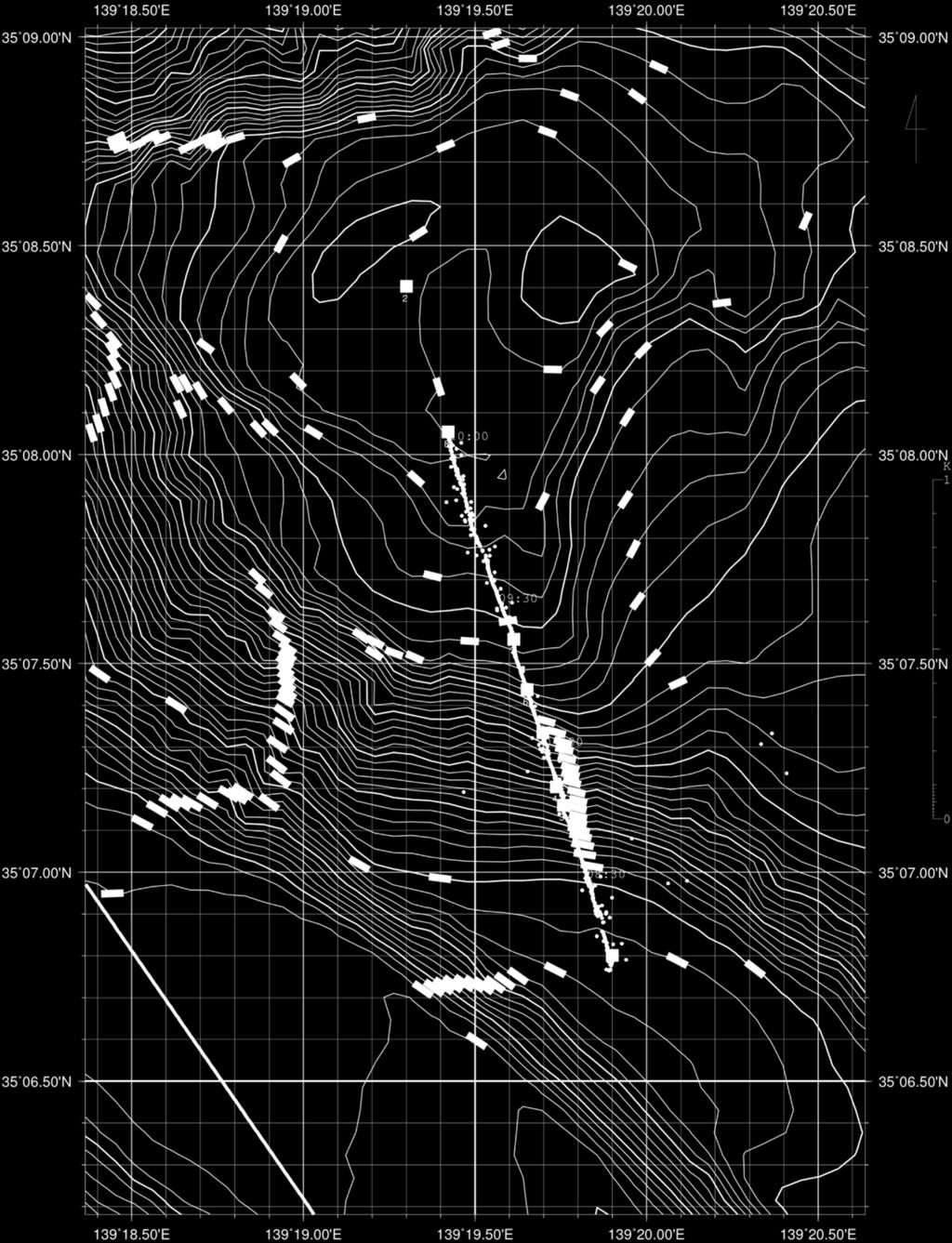
8 Navigation map of YKDT#160 7

9 Navigation map of YKDT#161 8
10 Bathymetric map at around YKDT#162 9
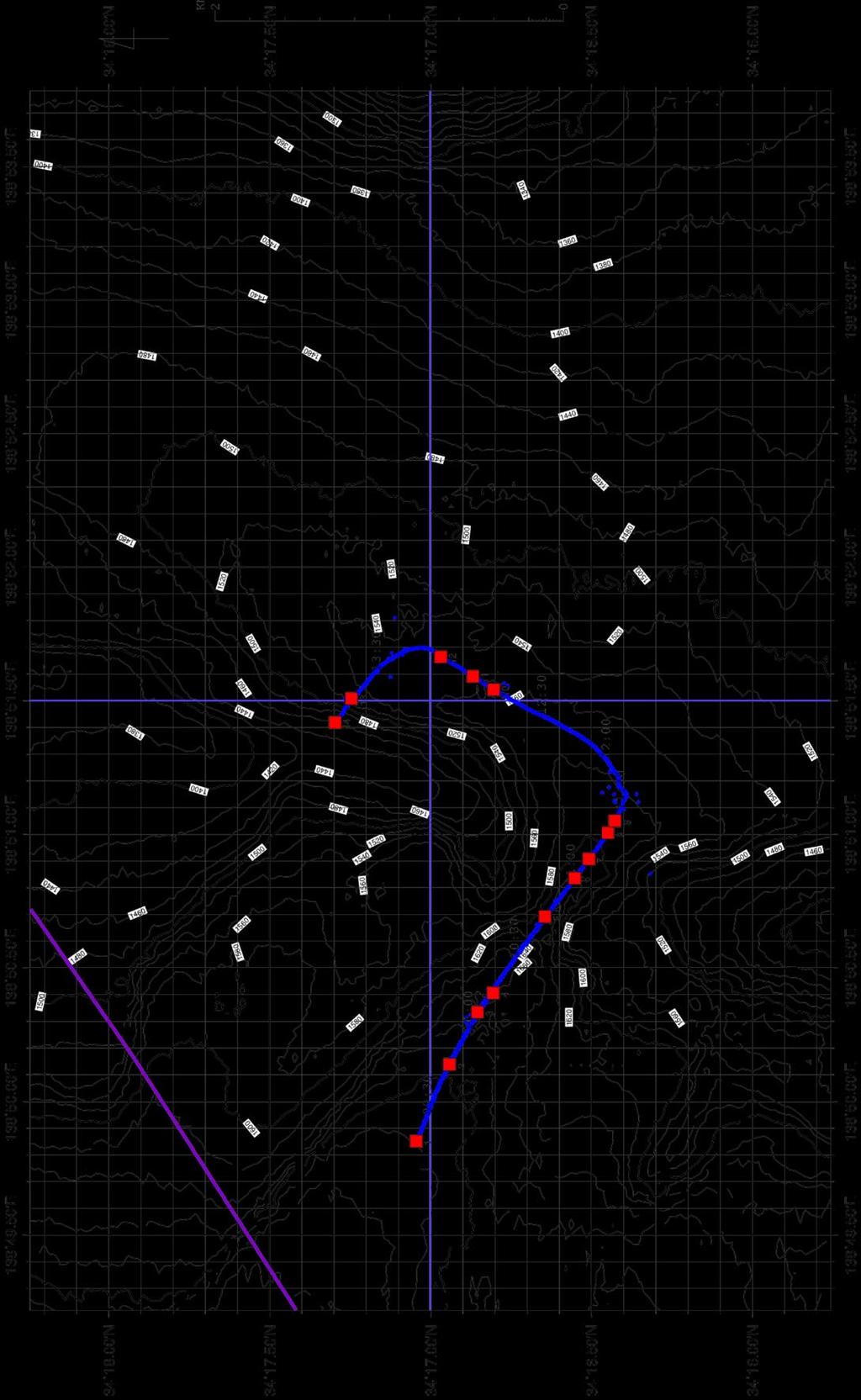

11 Navigation map of YKDT#162 10

 (SBE49, Sea-Bird Electronics)")

12 3.3. CTD observation For the purpose of the investigation of the ocean structure, we observed the spatial distributions of temperature and salinity using the conductivity, temperature, and depth profiler (CTD) (SBE49, Sea-Bird Electronics) attached on YKDT. Preliminary results are shown in following figures. Temporal profiles of depth, temperature, and salinity at YKDT#160 11


13 Temporal profiles of depth, temperature, and salinity at YKDT#161 12


14 Temporal profiles of depth, temperature, and salinity at YKDT#162 13
15 3.4. Geological observation Kantaro Fujioka [under contract with JAMSTEC] Naoki Takahashi [Natural History Museum and Institute, Chiba] Mistuharu Oshima [Kanagawa Prefectural Museum of Natural History] Shin ichi Mori [Hiratsuka City Museum] For the better understanding of the geology and the tectonic evolution of Sagami Bay in the light of the present plate tectonic framework we chose two selected geo-traverses crossing the Sagami knoll and Iro Canyon during NT14-22 cruise, respectively. The YKDT #160 dive started from the southern foot of the Sagami Knoll at water depth of 1,100m climbing up the knoll along N-S crossing route until the summit of the knoll. Many small slump scars and slope failure forming cliff and foot fan were observed during the dive. Several conglomerate formation mostly consisting of the volcanic pebbles and cobbles are encountered. The YKDT #161 dive was conducted from the middle slope of the knoll at water depth of 907m to 650m with dredger to get rock samples from the slope. At least 4 volcanic conglomerate layers were identified during the dive suggesting the volcanic activities occurred somewhere nearby location. Many mudstone and volcanic rock pebbles were collected to clarify the origin of these volcanic activities. The YKDT#162 dive was conducted from the Iro Canyon through the deep sea drainage divide to N-S trending unnamed Canyon which connected with Iro Canyon by the canyon capture event. The dive started from the canyon bottom at a water depth of 1700m to the East Canyon west wall at a water depth of 1443m. Various types of ripple marks were observed on the bottom of sandy mud to gravelly mud floors, which suggested the strong currents even under the deep sea condition, changed the direction frequently. Outcrops of basement rocks were volcanic rocks and mudstones which may derive from on-land Yugashima formation and the Shirahama formation, respectively. Rocks obtained using the dredge hauls with deep-tow system were volcanic rocks, mudstones and pumice fragments. These rocks may be derived from on land counterparts and volcanic eruption of the other volcanoes. During the cruise we realized that the Deep-tow system of JAMSTEC was quite useful for the observation of the deep sea bottom and also towing with dredge hauls and net systems were also useful for the geologic and biologic studies. 3.5 Biological observation Ryousuke Komi [Tokyo Sea Life Park] Satoru Matsumura [Tokyo Sea Life Park] Suguru Nemoto [Enoshima Aquarium] Saki Tominaga [Enoshima Aquarium] Naritomo Iwase [Keikyu Aburatsubo Marine Park] 14
16 Our main purpose of this cruse is to research deep sea creatures at the Sagami knoll and Iro Canyon by DEEP TOW. During the cruise (deep ocean floor survey system /DEEP TOW, Dives YKDT#160, #161, #162), we observed the deep sea floor in the real time, and collected deep sea creatures on the Dive YKDT#160 by DEEP TOW equipped with the plankton net and, on the Dive YKDT#161 by DEEP TOW equipped with the plankton net and the dredger. Our dive results are below. On the Dive YKDT#160, we observed Ophiuroidea sp. on the mad floor, and Asteroidea sp., Actiniaria sp., and Euplectellidae sp. clinging the precipice cliff or rocks during the water depth of 500m to 1,100m. Halosauridae sp., Macrouridae sp., Oplophoroidea sp. and, Congridae sp. (deep sea fish) were observed during the dive. The Plankton net captured Copepoda sp., Amphipoda sp., Copepoda sp., and Osteichthyes sp.. Those animals were made for the sample by using 70% Ethanol. On the Dive YKDT#161, the researching place is the same to the Dive YKDT#160. Observed deep sea creatures is similar to creatures on the the Dive YKDT#160. Halosauridae sp., Macrouridae sp., Oplophoroidea sp. and, Congridae sp. (deep sea fish) were observed during the dive. The Plankton net captured Cumacea sp., and fragment of Polychaeta sp., and Annelida sp.. The dredger collected Bryozoa sp., Gastropoda sp. and Ophiuroidae sp. during the water depth of 650m to 900m. It seems that benthos creatures were collected by the Plankton net because muds and soils were broken and resuspended by the dredger. Those animals were made for the sample by using 70% Ethanol. On the Dive YKDT#162, the dive started from the Iro canyon bottom at a water depth of 1700m to the East Canyon west wall at a water depth of 1443m. There are no mud floor, but Ophiuroidea sp., and Goniasteridae sp. were observed on bottom of the sandy mud to gravelly mud floors. Halosauridae sp., Macrouridae sp., Oplophoroidea sp. and, Congridae sp. were observed during this Dive YKDT#162. But there were few numbers of creatures compare with the Sagami knoll 4. Notice on Using This cruise report is a preliminary documentation as of the end of the cruise. This report may not be corrected even if changes on contents (i.e. taxonomic classifications) may be found after its publication. This report may also be changed without notice. Data on this cruise report may be raw or unprocessed. If you are going to use or refer to the data written on this report, please ask the Chief Scientist for latest information. Users of data or results on this cruise report are requested to submit their results to the Data Management Group of JAMSTEC. 15
R/V Kairei Cruise Report KR Seismic study in the northwestern Pacific region. Jan. 4, 2011 Jan. 20, 2011
 R/V Kairei Cruise Report KR11-01 Seismic study in the northwestern Pacific region Jan. 4, 2011 Jan. 20, 2011 Japan Agency for Marine-Earth Science and Technology (JAMSTEC) Contents: 1.Cruise Information:
S/V Yokosuka Cruise Report YK14-E02
 S/V Yokosuka Cruise Report YK14-E02 2014FY Marine geological and geophysical surveys to unravel the subduction zone great earthquakes and tsunamis : Seismic refraction and reflection survey in the outer
Cruise Report YK10-06
 Cruise Report YK10-06 (R/V Yokosuka) Site Surveys for drilling projects of IODP at the Kumano-nada and the northern Izu-Bonin arc June 13 20, 2010 Center for Deep Earth Exploration (CDEX) Japan Agency
R/V Kairei Cruise Report KR Seismic study in Nansei-Shoto Region. November 17, 2013 December 14, 2013
 R/V Kairei Cruise Report KR13-18 Seismic study in Nansei-Shoto Region November 17, 2013 December 14, 2013 Japan Agency for Marine-Earth Science and Technology (JAMSTEC) Contents: 1.Cruise Information:
Observation of Deep Seafloor by Autonomous Underwater Vehicle
 Indian Journal of Geo-Marine Sciences Vol. 42 (8), December 2013,pp. 1028-1033 Observation of Deep Seafloor by Autonomous Underwater Vehicle Tamaki Ura 1 Underwater Technology Research Center, Institute
Small area of the ocean that is partially surrounded by land. The Ocean Basins. Three Major Oceans. Three Major Oceans. What is a SEA?
 The Ocean Basins How Deep is the Ocean? 1 2 Three Major Oceans Three Major Oceans Pacific Atlantic the shallowest ocean (3.3km average depth) Indian second shallowest ocean (3.8km average depth) Pacific
Observation of Deep Seafloor by Autonomous Underwater Vehicle
 Observation of Deep Seafloor by Autonomous Underwater Vehicle Tamaki Ura 1 Underwater Technology Research Center Institute of Industrial Science, The University of Tokyo 4-6-1, Komaba, Minato, Tokyo, Japan
Chapter Overview. Bathymetry. Measuring Bathymetry. Measuring Bathymetry
 CHAPTER 3 Marine Provinces Chapter Overview The study of bathymetry determines ocean depths and ocean floor topography. Echo sounding and satellites are efficient bathymetric tools. Most ocean floor features
1. Name at least one place that the mid-atlantic Ridge is exposed above sea level.
 Interpreting Tectonic and Bathymetric Maps. The purpose of this lab is to provide experience interpreting the bathymetry of the seafloor in terms of tectonic and geologic settings and processes. Use the
Map shows 3 main features of ocean floor
 Map shows 3 main features of ocean floor 2017 Pearson Education, Inc. Chapter 3 Marine Provinces 2017 Pearson Education, Inc. 1 Chapter 3 Overview The study of bathymetry determines ocean depths and ocean
Bathymetry Measures the vertical distance from the ocean surface to mountains, valleys, plains, and other sea floor features
 1 2 3 4 5 6 7 8 9 10 11 CHAPTER 3 Marine Provinces Chapter Overview The study of bathymetry determines ocean depths and ocean floor topography. Echo sounding and satellites are efficient bathymetric tools.
Coordinates : A - of midpoint or summit : Lat., Long. } to. Description (kind of feature) : seachannel
 : seachannel") INTERNATIONAL HYDROGRAPHIC ORGANIZATION INTERGOVERNMENTAL OCEANOGRAPHIC COMMISSION (of UNESCO) IHO/IOC Form No. 1 UNDERSEA FEATURE NAME PROPOSAL (See NOTE overleaf) Ocean or Sea Japan Sea Name proposed
INTERNATIONAL HYDROGRAPHIC ORGANIZATION INTERGOVERNMENTAL OCEANOGRAPHIC COMMISSION (of UNESCO) IHO/IOC Form No. 1 UNDERSEA FEATURE NAME PROPOSAL (See NOTE overleaf) Ocean or Sea Japan Sea Name proposed
CHAPTER 28. PHYSIOGRAPHY Cook Inlet Drainages
 PEBBLE PROJECT ENVIRONMENTAL BASELINE DOCUMENT 2004 through 2008 CHAPTER 28. PHYSIOGRAPHY Cook Inlet Drainages PREPARED BY: Knight Piésold Ltd. PHYSIOGRAPHY COOK INLET DRAINAGES TABLE OF CONTENTS TABLE
Meteor-Cruise M 75 / 2 Short Cruise Report Chief scientist: Dr. Jürgen Pätzold Universität Bremen Bremen / Germany
 Meteor-Cruise M 75 / 2 Short Cruise Report Chief scientist: Dr. Jürgen Pätzold Universität Bremen Bremen / Germany Dar es Salaam Dar es Salaam Febr. 06 th Febr. 24 th, 2008 1 SHORT CRUISE REPORT RV METEOR
Earth / Environmental Science. Ch. 14 THE OCEAN FLOOR
 Earth / Environmental Science Ch. 14 THE OCEAN FLOOR The Blue Planet Nearly 70% of the Earth s surface is covered by the global ocean It was not until the 1800s that the ocean became an important focus
Marine Ecology Pacing Guide
 Marine Ecology Pacing Guide Course Description: The focus of the course is the interrelationships among marine organisms and the physical, chemical, geological and biological factors. North Carolina coastal
Name Class Date. The ocean floor has varied and distinct surfaces much like those found on land.
 6 Explore the Seafloor BigIdeas The ocean floor has varied and distinct surfaces much like those found on land. Satellites orbiting Earth, as well as sonar technology, are used to map the seafloor. The
Field trip guide to the Marin Headlands (Golden Gate National Recreation Area) and the Point Reyes National Seashore
 and the Point Reyes National Seashore") Name: Field trip guide to the Marin Headlands (Golden Gate National Recreation Area) and the Point Reyes National Seashore Geology of the National Parks San Francisco State University April 20, 2002 DRIVING
Name: Field trip guide to the Marin Headlands (Golden Gate National Recreation Area) and the Point Reyes National Seashore Geology of the National Parks San Francisco State University April 20, 2002 DRIVING
Magnetic and Bathymetric Survey of the Suiyo Cross-Chain, Izu-Bonin Arc
 JAMSTEC Report of Research and Development, Volume 6, November 2007, 31 38 Magnetic and Bathymetric Survey of the Suiyo Cross-Chain, Izu-Bonin Arc Toshiya Fujiwara 1, Osamu Ishizuka 2, Yoshihiko Tamura
WHAT IS THE EARTH MADE OF? LITHOSPHERE AND HYDROSPHERE
 UNIT 8 WHAT IS THE EARTH MADE OF? LITHOSPHERE AND HYDROSPHERE TABLE OF CONTENTS 1 THE STRUCTURE OF THE EARTH... 2 2 THE FORMATION OF THE RELIEF: INTERNAL AND EXTERNAL FORCES.... 2 2.1 Internal forces:
Introduction to Acoustic Remote Sensing and Seafloor Mapping (AE4-E13) May 19, 2010
 May 19, 2010") Introduction to Acoustic Remote Sensing and Seafloor Mapping (AE4-E13) May 19, 2010 1 Delft Vermelding Institute onderdeel of Earth organisatie Observation and Space Systems Why Acoustic Remote Sensing?
Introduction to Acoustic Remote Sensing and Seafloor Mapping (AE4-E13) May 19, 2010 1 Delft Vermelding Institute onderdeel of Earth organisatie Observation and Space Systems Why Acoustic Remote Sensing?
OCEAN ZONES. 1. Intertidal Zone 2. Near-Shore Zone 3. Open-Ocean Zone
 OCEAN ZONES 1. Intertidal Zone 2. Near-Shore Zone 3. Open-Ocean Zone Where the Ocean Meets the Land (Place) Intertidal Zone The intertidal zone is the area between the high- and low-tide lines. At high
OCEAN ZONES. 1. Intertidal Zone 2. Near-Shore Zone 3. Open-Ocean Zone
 OCEAN ZONES 1. Intertidal Zone 2. Near-Shore Zone 3. Open-Ocean Zone Where the Ocean Meets the Land (Place) Intertidal Zone The intertidal zone is the area between the high- and low-tide lines. At high
Submersible investigation of unconfirmed western Miami Terrace habitat
 Submersible investigation of unconfirmed western Miami Terrace habitat Prepared By: Brian K. Walker, Ph.D. Nova Southeastern University Oceanographic Center 6/08/2015 On June 5, 2015 Nova Southeastern
Fine-scale Survey of Right and Humpback Whale Prey Abundance and Distribution
 DISTRIBUTION STATEMENT A: Approved for public release; distribution is unlimited. Fine-scale Survey of Right and Humpback Whale Prey Abundance and Distribution Joseph D. Warren School of Marine and Atmospheric
National Marine Sanctuary Program
 National Marine Sanctuary Program NMSP/USGS Joint Seabed Mapping Initiative: September 2004 AA National Ocean Service National Marine Sanctuaries Interim Report September 2004 Background: Since 2002,
The Marine Environment
 The Marine Environment SECTION 16.1 Shoreline Features In your textbook, read about erosional landforms, beaches, estuaries, longshore currents, and rip currents. For each statement below, write or. 1.
What type of land feature is located at Point A? A Cliff B Delta C Mountain D Valley
 1 What type of land feature is located at Point A? A Cliff B Delta C Mountain D Valley Alfred Wegener s theory of continental drift was 2 not accepted by scientists when the theory was first proposed.
Japan Agency for Marine-Earth Science and Technology (JAMSTEC), 2-15 Natsushima-cho, Yokosuka, Kanagawa, , JAPAN
, 2-15 Natsushima-cho, Yokosuka, Kanagawa, , JAPAN") LARGE EARTHQUAKE AND ASSOCIATED PHENOMENA OBSERVED WITH SEAFLOOR CABLED OBSERVATORY NEAR EPICENTER - AN IMPLICATION FOR POSSIBLE ADDITIONAL MEASUREMENT WITH TELECOMMUNICATION NETWORKS FOR IDENTIFICATION
LARGE EARTHQUAKE AND ASSOCIATED PHENOMENA OBSERVED WITH SEAFLOOR CABLED OBSERVATORY NEAR EPICENTER - AN IMPLICATION FOR POSSIBLE ADDITIONAL MEASUREMENT WITH TELECOMMUNICATION NETWORKS FOR IDENTIFICATION
MARINE GEOLOGY & GEOGRAPHY
 MARINE GEOLOGY & GEOGRAPHY Bathymetry BATHYMETRY BATHYMETRY THE UNDERWATER EQUIVALENT TO TOPOGRAPHY THE STUDY OF WATER DEPTH A BATHYMETRIC MAP SHOWS FLOOR RELIEF OR TERRAIN AS CONTOUR LINES Bathymetry
Depositional Environments. Depositional Environments
 Depositional Environments Geographic area in which sediment is deposited Characterized by a combination of geological process & environmental conditions Depositional Environments Geological processes:
Question #1: What are some ways that you think the climate may have changed in the area where you live over the past million years?
 Reading 5.2 Environmental Change Think about the area where you live. You may see changes in the landscape in that area over a year. Some of those changes are weather related. Others are due to how the
Folding. Faulting. Volcanoes
 Folding Faulting Volcanoes Most major global mountain ranges were formed by the collision of continental (tectonic) plates Fold mountains are actually formed by crust which have been uplifted and folded
Unit 7.2 W.E.D. & Topography Test
 Name: Score: Unit 7.2 W.E.D. & Topography Test 1. 2. 3. 4. 5. 6. 7. 8. 9. 10. 11. 12. 13. 14. 15. 16. 17. 18. 19. 20. 21. 22. 23. 24. 25. 1. The formation of mountains is due mainly to while the destruction
Sediment and sedimentary rocks Sediment
 Sediment and sedimentary rocks Sediment From sediments to sedimentary rocks (transportation, deposition, preservation and lithification) Types of sedimentary rocks (clastic, chemical and organic) Sedimentary
Sediment and Sedimentary rock
 Sediment and Sedimentary rock Sediment: An accumulation of loose mineral grains, such as boulders, pebbles, sand, silt or mud, which are not cemented together. Mechanical and chemical weathering produces
The surface of the ocean floor is as varied as the land. The five major oceans, from largest to smallest, are
 11.1 Ocean Basins The surface of the ocean floor is as varied as the land. The five major oceans, from largest to smallest, are w the Pacific w the Atlantic w the Indian w the Southern w the Arctic The
The Marine Environment
 The Marine Environment SECTION 16.1 Shoreline Features In your textbook, read about erosional landforms, beaches, estuaries, longshore currents, and rip currents. For each statement below, write true or
Oceanography Field Trip One Key
 Oceanography Field Trip One Key If you are using this key as a make-up guide, you should get a COLOR version of this field trip guide by going to http://www.mpcfaculty.net/alfred_hochstaedter/oceanography.htm
The Variety of Maps By ReadWorks
 The Variety of Maps By ReadWorks Maps are known for helping us figure out how to get to a certain location: which road do I take to the ice-cream parlor? How do I get from my house to my best friend s?
Satellite detection of volcanic aerosol at Miyakejima and Sakurajima
 Nagasaki Workshop on Aerosol-Cloud Radiation Interaction and Asian Lider Network, Nagasaki, Japan, Nov. 2001 Satellite detection of volcanic aerosol at Miyakejima and Sakurajima M. Koyamada, K. Kinoshita,
ARE YOU READY TO THINK? Look at the first slide THINK PAIR SHARE!
 ARE YOU READY TO THINK? Look at the first slide THINK PAIR SHARE! WHAT PROMINENT FEATURE CAN YOU IDENTIFY IN THIS PICTURE? What do you think the different colors represent? Who might find such a picture
The East of Nantucket Survey. Preliminary Results Presented by Eric Powell to the Habitat PDT on September 14, 2017
 The East of Nantucket Survey Preliminary Results Presented by Eric Powell to the Habitat PDT on September 14, 2017 Thanks Roger Mann who handled the logistics of the cruise Tom Dameron and others who provided
'0"W. Sigguk 70 45'0"N. B a f f i n. B a y. Bathymetric high referenced in section A l h a. g e. o u g h. i d.
 p 60 50'0"W Baffin Bay Greenland Sigguk B a f f i n B a y S h e l f E d g e Beta 8 6 5 4 19 21 U u m m a n n a q C h a n n e l Note: Lineaments are iceberg scours Gamma 3 10 12 1 11 2 Bathymetric high
Large submarine landslides in the Japan Trench: A new scenario for additional tsunami generation
 GEOPHYSICAL RESEARCH LETTERS, VOL. 39,, doi:10.1029/2011gl050661, 2012 Large submarine landslides in the Japan Trench: A new scenario for additional tsunami generation Kiichiro Kawamura, 1,2 Tomoyuki Sasaki,
Depositional Environment
 Depositional Environment Sedimentary depositional environment describes the combination of physical, chemical and biological processes associated with the deposition of a particular type of sediment. Types
89. Wakamiko. Summary. Latitude: ' N, Longitude: ' E, Depth: -77 m (Central cone) (89. Wakamiko)
 (89. Wakamiko)") 89. Wakamiko Latitude: 31 39.8' N, Longitude: 130 47.9' E, Depth: -77 m (Central cone) Summary Wakamiko is a submarine caldera located in the northeast corner of the Aira caldera, located deep in Kagoshima
89. Wakamiko Latitude: 31 39.8' N, Longitude: 130 47.9' E, Depth: -77 m (Central cone) Summary Wakamiko is a submarine caldera located in the northeast corner of the Aira caldera, located deep in Kagoshima
Marine Science and Oceanography
 Marine Science and Oceanography Marine geology- study of the ocean floor Physical oceanography- study of waves, currents, and tides Marine biology study of nature and distribution of marine organisms Chemical
Chapter 2 Plate Tectonics and the Ocean Floor
 Chapter 2 Plate Tectonics and the Ocean Floor Matching. Match the term or person with the appropriate phrase. You may use each answer once, more than once or not at all. 1. hydrothermal vents A. convergent
Science 8 - Water Systems Test - Chapters 1-2
 Science 8 - Water Systems Test - Chapters 1-2 Multiple Choice (30 marks) Identify the choice that best completes the statement or answers the question. 1. What percentage represents the amount of fresh
Crater, fault, volcanic cone, lava flow
 2-1 INTERNATIONAL HYDROGRAPHIC ORGANIZATION INTERGOVERNMENTAL OCEANOGRAPHIC COMMISSION (of UNESCO) Note: The boxes will expand as you fill the form. UNDERSEA FEATURE NAME PROPOSAL (Sea NOTE overleaf) Name
UNDERSEA FEATURE NAME PROPOSAL (Sea NOTE overleaf) Matoba Seamount
 Matoba Seamount") 2-1 INTERNATIONAL HYDROGRAPHIC ORGANIZATION INTERGOVERNMENTAL OCEANOGRAPHIC COMMISSION (of UNESCO) Note: The boxes will expand as you fill the form. UNDERSEA FEATURE NAME PROPOSAL (Sea NOTE overleaf) Name
2-1 INTERNATIONAL HYDROGRAPHIC ORGANIZATION INTERGOVERNMENTAL OCEANOGRAPHIC COMMISSION (of UNESCO) Note: The boxes will expand as you fill the form. UNDERSEA FEATURE NAME PROPOSAL (Sea NOTE overleaf) Name
The Variety of Maps By ReadWorks
 The Variety of Maps By ReadWorks Maps are known for helping us figure out how to get to a certain location: which road do I take to the ice-cream parlor? How do I get from my house to my best friend s?
Materials needed: ISNs (students & teacher), document camera, self-reflection pages, corrected tests
, document camera, self-reflection pages, corrected tests") Science April 6-10 L.HE.05.11 Explain that the traits of an individual are influenced by both the environment and the genetics of the individual. L.HE.05.12 Distinguish between inherited and acquired traits.
Science April 6-10 L.HE.05.11 Explain that the traits of an individual are influenced by both the environment and the genetics of the individual. L.HE.05.12 Distinguish between inherited and acquired traits.
Crustal Activity. Plate Tectonics - Plates - Lithosphere - Asthenosphere - Earth s surface consists of a major plates and some minor ones
 Name: Date: Period: Tectonics The Physical Setting: Earth Science CLASS NOTES Tectonics - s - Lithosphere - Asthenosphere - Earth s surface consists of a major plates and some minor ones The plates are
Physiography Ocean Provinces p. 1 Dimensions p. 1 Physiographic Provinces p. 2 Continental Margin Province p. 2 Deep-Ocean Basin Province p.
 Physiography Ocean Provinces p. 1 Dimensions p. 1 Physiographic Provinces p. 2 Continental Margin Province p. 2 Deep-Ocean Basin Province p. 2 Mid-Ocean Ridge Province p. 3 Benthic and Pelagic Provinces
Demonstrate knowledge of Earth Science. US (v5), 2 credits
, 2 credits") GEOLOGY UNIT STANDARD Demonstrate knowledge of Earth Science US 18982 (v5), 2 credits UNIT STANDARD Title: Demonstrate knowledge of Earth science Level: 1 Credits: 2 Purpose: People credited with this
GEOLOGY UNIT STANDARD Demonstrate knowledge of Earth Science US 18982 (v5), 2 credits UNIT STANDARD Title: Demonstrate knowledge of Earth science Level: 1 Credits: 2 Purpose: People credited with this
MR99-K04 Cruise Summary
 MR99-K04 Cruise Summary 1. Introduction Oceanic conditions in the subtropical and subarctic gyres, especially in and around the Kurishio Extension, are thouth to be important to the North Pacific decadal/interdecadal
Bifurcation Current along the Southwest Coast of the Kii Peninsula
 Journal of Oceanography, Vol. 54, pp. 45 to 52. 1998 Bifurcation Current along the Southwest Coast of the Kii Peninsula JUNICHI TAKEUCHI 1, NAOTO HONDA 2, YOSHITAKA MORIKAWA 2, TAKASHI KOIKE 2 and YUTAKA
Geosphere Final Exam Study Guide
 Geosphere Final Exam Study Guide Chapter 1 Intro to Earth Systems 1. Name and describe Earth s 4 major spheres Geosphere-- nonliving, mostly solid rock divided into crust, mantle, and core Atmosphere a
Name Class Date. Study Guide for 7 th Grade Final Exam (Semester One)
") Name Class Date Study Guide for 7 th Grade Final Exam (Semester One) 1. What are the steps of the scientific method? Define the problem or question Form a hypothesis (MUST BE TESTABLE) o (identify variables)
Name Class Date Study Guide for 7 th Grade Final Exam (Semester One) 1. What are the steps of the scientific method? Define the problem or question Form a hypothesis (MUST BE TESTABLE) o (identify variables)
UNIT 1: WATER SYSTEMS ON EARTH CHAPTER 2: OCEANS CONTROL THE WATER CYCLE
 UNIT 1: WATER SYSTEMS ON EARTH CHAPTER 2: OCEANS CONTROL THE WATER CYCLE ORIGINS OF OCEAN WATER OCEANS HAVE FILLED OVER HUNDREDS OF MILLIONS OF YEARS SCIENTISTS BELIEVE THE OCEANS ARE MORE THAN 3 BILLION
Geography of the world s oceans and major current systems. Lecture 2
 Geography of the world s oceans and major current systems Lecture 2 WHY is the GEOMORPHOLOGY OF THE OCEAN FLOOR important? (in the context of Oceanography) WHY is the GEOMORPHOLOGY OF THE OCEAN FLOOR important?
GLY 155 Introduction to Physical Geology, W. Altermann. Press & Siever, compressive forces. Compressive forces cause folding and faulting.
 Press & Siever, 1995 compressive forces Compressive forces cause folding and faulting. faults 1 Uplift is followed by erosion, which creates new horizontal surface. lava flows Volcanic eruptions cover
2. Identify other PIs associated with the cruise: 3. Identify the at-sea Chief Scientist: Charles Langmuir
 Pre-Cruise Meeting April 17, 2014 AT26-19, Charles Langmuir, Aug 28 Sept 11, 2014. RV Atlantis with OSU Coring Facility General Program Overview: 1. Scientific Objectives: Our aim is to obtain as many
Phillip Island Nature Parks Coastal Process Study 8 October 2014
 Phillip Island Nature Parks Coastal Process Study 8 October 2014 Project Overview Coastal Geology Basaltic and fragmented lavas, granite at Pyramid Rock and Cape Woolamai Weathered basalt (>10m thick)
Latitude: 34 31'13" N, Longitude: '45" E, Elevation: 508 m (Miyatsukayama) (Triangulation Point - Toshima)
 (Triangulation Point - Toshima)") 59. Toshima Latitude: 34 31'13" N, Longitude: 139 16'45" E, Elevation: 508 m (Miyatsukayama) (Triangulation Point - Toshima) Overview of Toshima taken from northwest side on October 30, 2002 by the Japan
59. Toshima Latitude: 34 31'13" N, Longitude: 139 16'45" E, Elevation: 508 m (Miyatsukayama) (Triangulation Point - Toshima) Overview of Toshima taken from northwest side on October 30, 2002 by the Japan
Earth Science S5E1b (EarthScienceS5E1b)
") Name: Date: 1. The flattest part of the ocean floor is the A. trench. B. abyssal plain. C. continental shelf. D. mid-ocean rift valley. 2. Which causes some parts of the ocean to be saltier than other
Name: Date: 1. The flattest part of the ocean floor is the A. trench. B. abyssal plain. C. continental shelf. D. mid-ocean rift valley. 2. Which causes some parts of the ocean to be saltier than other
Marine Sediments EPSS15 Spring 2017 Lab 4
 Marine Sediments EPSS15 Spring 2017 Lab 4 Why Sediments? Record of Earth s history - Tectonic plate movement - Past changes in climate - Ancient ocean circulation currents - Cataclysmic events 1 Classification
3.1 GEOLOGY AND SOILS Introduction Definition of Resource
 3.1 GEOLOGY AND SOILS 3.1.1 Introduction 3.1.1.1 Definition of Resource The geologic resources of an area consist of all soil and bedrock materials. This includes sediments and rock outcroppings in the
Tips for Success on a Test
 Number of Incorrect: Final Grade: Parent Signature: Top Tips for Success on a Test 1. Read the following statements at least two times. 2. Circle the key words in each question/ or statement. (*Remember
YOKOSUKA Cruise Report YK Evaluation cruise for hybrid submersible gravity. observation system for exploration
 YOKOSUKA Cruise Report YK13-13 Evaluation cruise for hybrid submersible gravity observation system for exploration Izena Caldera in the middle Okinawa trough Dec. 6, 2013 - Dec. 14, 2013 Japan Agency for
Almost of Earth is covered by water. On a map, the continents appear as huge islands surrounded by a vast global ocean.
 Earth s Oceans & Ocean Floor Date: Feelin Blue What are Earth s five main oceans? Almost of Earth is covered by water. On a map, the continents appear as huge islands surrounded by a vast global ocean.
Sedimentary Structures in Metamorphic Rocks
 Maine Geologic Facts and Localities November, 2006 Primary Sedimentary Structures in Some Metamorphic Rocks Text by Thomas K. Weddle, Department of Agriculture, Conservation & Forestry 1 Photo by Thomas
Glacial Geology of Moose Point State Park, ME
 Geologic Site of the Month May, 2013 Glacial Geology of Moose Point State Park, Maine 44 o 25 59.18"N, 68 o 56 37.11"W Text and photos by Woodrow B. Thompson, Department of Agriculture, Conservation &
BOEM Marine Minerals Program
 BOEM Marine Minerals Program Restoring and Protecting Our Nation s Coasts through Stewardship of OCS Sand Resources SECOORA 2018 Annual Meeting May 22-24 Doug Piatkowski Douglas.piatkowski@boem.gov 703-787-1833
Plate Climatology Theory* by James Edward Kamis 21 October 2014
 Plate Climatology Theory* by James Edward Kamis 21 October 2014 Synopsis The Sun, quite obviously, is the first order driver of Earth s climate, but a much neglected second order driver can contribute
TAKE HOME EXAM 8R - Geology
 Name Period Date TAKE HOME EXAM 8R - Geology PART 1 - Multiple Choice 1. A volcanic cone made up of alternating layers of lava and rock particles is a cone. a. cinder b. lava c. shield d. composite 2.
program Mobilise Brisbane 0800 hrs, Thursday, January 17 th, 2013 Depart Brisbane 0800 hrs, Friday, January 18 th 2013
 2012 RV Southern Surveyor program voyageplan ss2013_v01 Submarine landslides offshore northern New South Wales and southern Queensland: their geomechanical characteristics, timing and triggers. Itinerary
Earth Structures and Processes Teacher Notes
 Aleutian Islands String of islands resulting from volcanic activity Part of the Pacific Ring of Fire Coast is very jagged and rocky with steep cliffs and mountains Underwater eruptions form new landforms
Maine Geologic Facts and Localities October, Lobster Lake, Maine. Text by Robert G. Marvinney. Maine Geological Survey
 Maine Geologic Facts and Localities October, 1998 Lobster Lake, Maine 45 o 51 7.91 N, 69 o 30 53.88 W Text by Robert G. Marvinney, Department of Agriculture, Conservation & Forestry 1 Map by Introduction
Y. Shioi 1, Y. Hashizume 2 and H. Fukada 3
 Y. Shioi 1, Y. Hashizume 2 and H. Fukada 3 1 Emeritus Professor, Hachinohe Institute of Technology, Hachinohe, Japan 2 Chief Engineer, Izumo, Misawa, Aomori, Japan 3 Profesr, Geo-Technical Division, Fudo
Deep Seismic Profiling in the Tokyo Metropolitan Area for Strong Ground Motion Prediction
 Deep Seismic Profiling in the Tokyo Metropolitan Area for Strong Ground Motion Prediction Hiroshi Sato 1, Naoshi Hirata 1, Takaya Iwasaki 1, Kazuki Koketsu 1, Tanio Ito 2, Keiji Kasahara 3, Kiyoshi Ito
UNIVERSITY OF NAIROBI
 UNIVERSITY OF NAIROBI SPEECH DELIVERED BY THE VICE-CHANCELLOR PROF. G.A.O. MAGOHA DURING THE KENYA JAPAN EXCHANGE SEMINAR ON OCEAN SCIENCE COOPERATING TOWARDS A BETTER PLANET EARTH ON 16 TH JANUARY 2006
Marine biologists have identified over 250,000 marine species. This number is constantly increasing as new organisms are discovered.
 A wide variety of organisms inhabit the marine environment. These organisms range in size from microscopic bacteria and algae to the largest organisms alive today blue whales, which are as long as three
Plate Tectonics Tutoiral. Questions. Teacher: Mrs. Zimmerman. Plate Tectonics and Mountains Practice Test
 Teacher: Mrs. Zimmerman Print Close Plate Tectonics and Mountains Practice Test Plate Tectonics Tutoiral URL: http://www.hartrao.ac.za/geodesy/tectonics.html Questions 1. Fossils of organisms that lived
Express EARTH SCIENCE. The breakdown of rocks by physical means.
 Express EARTH SCIENCE and SP CE The breakdown of rocks by physical means. 1 Mechanical Weathering Upon successful completion of this unit, you will be able to do the following: Explain how weathering and
Clastic Sedimentary Rocks
 Clastic Sedimentary Rocks Alessandro Grippo, Ph.D. Alternating sandstones and mudstones in Miocene turbidites Camaggiore di Firenzuola, Firenze, Italy Alessandro Grippo review Mechanical weathering creates
1 Earth s Oceans. TAKE A LOOK 2. Identify What are the five main oceans?
 CHAPTER 13 1 Earth s Oceans SECTION Exploring the Oceans BEFORE YOU READ After you read this section, you should be able to answer these questions: What affects the salinity of ocean water? What affects
MULTIPLE CHOICE. Choose the one alternative that best completes the statement or answers the question.
 Geology 300, Physical Geology Spring 2019 Quiz Chapter 18, Seafloor Name MULTIPLE CHOICE. Choose the one alternative that best completes the statement or answers the question. 1) Abyssal fans are made
Reading Material. See class website. Sediments, from Oceanography M.G. Gross, Prentice-Hall
 Reading Material See class website Sediments, from Oceanography M.G. Gross, Prentice-Hall Materials filling ocean basins Dissolved chemicals especially from rivers and mid-ocean ridges (volcanic eruptions)
Outcrops from Every Continent and 20 Countries in 140 Contributions. Tor H. Nilsen, Roger D. Shew, Gary S. Steffens, and Joseph R.J. Studlick.
 Paper VIII Tor H. Nilsen, Roger D. Shew, Gary S. Steffens, and Joseph R.J. Studlick Editors Outcrops from Every Continent and 20 Countries in 140 Contributions http://bookstore.aapg.org Length ~ 23 m (75.5
A Study on the Risk Assessment of Emergency Supplies. Transportation Routes Considering Scenario Earthquakes
 ORIGINAL ARTICLE A Study on the Risk Assessment of Emergency Supplies Transportation s Considering Scenario Earthquakes Kazuaki Torisawa 1, Harumi Yashiro 2, Sei ichiro Fukushima 3*, Satoshi Kina 4 1 Kajima
68. Izu-Torishima. Summary. Latitude: 30 29'02" N, Longitude: '11" E, Elevation: 394 m (Ioyama) (Elevation Point) (68.
 (Elevation Point) (68.") 68. Izu-Torishima Latitude: 30 29'02" N, Longitude: 140 18'11" E, Elevation: 394 m (Ioyama) (Elevation Point) Izu-Torishima taken from southeast side on August 12, 2002. Courtesy of the Maritime Safety
68. Izu-Torishima Latitude: 30 29'02" N, Longitude: 140 18'11" E, Elevation: 394 m (Ioyama) (Elevation Point) Izu-Torishima taken from southeast side on August 12, 2002. Courtesy of the Maritime Safety
System. A system is a set of connected things or parts forming a complex whole.
 Earth Systems What is a system? System A system is a set of connected things or parts forming a complex whole. Open vs. Closed System Open vs. Closed System Open System a system in which both energy and
Science --- San Francisco Chronicle
 Science --- San Francisco Chronicle 8-1-2013 Google's voyage to bottom of the sea's dead zone Google executive Schmidt backs ship's scientific expeditions Jason Henry, Special To The Chronicle Research
24. Ocean Basins p
 24. Ocean Basins p. 350-372 Background The majority of the planet is covered by ocean- about %. So the majority of the Earth s crust is. This crust is hidden from view beneath the water so it is not as
Baltic Sea Research Institute
 Baltic Sea Research Institute Warnemuende (IOW) Cruise Report No. 44/96/ 04 R/V "A.v.Humboldt" MESODYN Cruise 01 to 12 March 1996 Stolpe Furrow / Baltic Sea This report is based on preliminary data and
Z046 Seismic Characteristics of Gas Migration Structures on the North Atlantic Margin Imaged by High-resolution 3D Seismic
 Z046 Seismic Characteristics of Gas Migration Structures on the North Atlantic Margin Imaged by High-resolution 3D Seismic O.K. Eriksen* (P-Cable 3D Seismic), C. Berndt (IFM-GEOMAR), S. Buenz (University
Major Factors influencing Seamount Niches
 2018 May 27-30, Quindao, China International Workshop of the REMP for the Cobalt-Rich Ferromanganese Crust in the Triangle Area in the northwest Pacific Ocean Major Factors influencing Seamount Niches