Geology & Teaching Geology in the Lander Sinks Canyon Area
|
|
|
- Philippa McKenzie
- 5 years ago
- Views:
Transcription

1 Geology & Teaching Geology in the Lander Sinks Canyon Area A Historical Perspective from the University of Missouri s s Branson Field Laboratory - Bob Bauer -


2 This Evening s s Presentation Why does MU come here? What is the history of our course and the camp? What do we study & why? What s so great about the geology here?


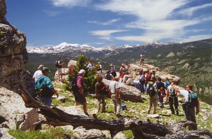


3 Why are we here? Exposure you can see the rocks Diversity of geology Spectacular geology A great teaching setting


4 Edwin Bayer Branson - MU Professor & Early Pioneer of Field Geology Teaching 1911 Branson first brought students from Missouri to Sinks Canyon to learn about the diverse geology in Wyoming


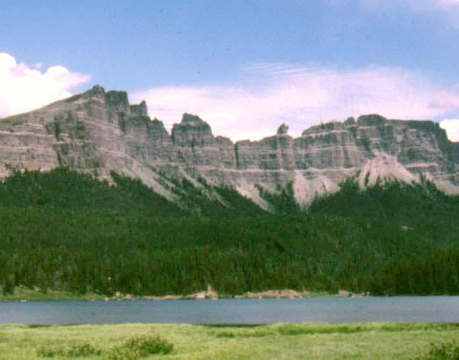
5 In the early camp years, tents dotted the various canyons on the northeast slope of the Wind River Mountains. Soon the Middle Fork Popo Agie River became the favorite camp site of the students and instructors

6 Mrs. Branson generally accompanied the group Cynthia Wilkes and Branson's wife, Grace Muriel Branson, are reportedly the first women to climb Wind River Peak on Aug. 4, 1913 (accompanied by a student identified only as Adams)

7 More MU faculty joined Branson, and geology students from many mid-western and eastern universities also attended our course In the 1920 s s & 30 s In the mid 1920 s, the University obtained a long-term educational permit in Sinks Canyon from the U.S. Forest Service


8 Construction of cabins began on the site of the current camp in the mid to late 1920 s

9 By 1949

10 The Camp Today

11 What do we teach? In the broadest sense, we teach students how to apply classroom studies to practical problems of geologic history and processes in a real-world field setting


12 What do we study & why? We teach students How to recognize features in rocks that help us understand how they were formed: Their history of formation The process that produced the rocks Processes that may have altered the rocks
13 We teach students to map geology By rock type, by unit name, by age Provides information on geologic history Provides information for industry & environmental monitoring Students learn to think in 4D (3D+time)


14 We teach students to measure & analyze the orientation of rocks & rock features The Brunton compass Rock hammer Hand lens The GPS receiver Topographic maps How do mountains form?


15 We teach students how to understand and analyze on-going earth environmental processes Chemical analyses Shallow well drilling Core analysis Stream measurements Remote sensing using geophysical techniques
16 Why is this area such a great place to study geology? NW Wyoming is one of the most diverse geologic settings in the world Very long geologic history recorded Many stages of mountain building Many stages of volcanic activity


17 The long rock record Rocks as olds as 3 billion years old (2.65 billion rocks on Granite Knob) A long rock record from the head of sinks canyon into the basin


18 Many stages of diverse mountain building Sevier event ~ m.y. ago Laramide event ~ m.y. ago Block faulting Grand Tetons

19 Multiple Stages of Volcanism Absaroka volcanism million years ago Yellowstone volcanism 2 million ~1.2 million 600,000 events

20 Alpine Glaciation Glaciers that formed in high mountain settings during iceage (Pleistocene) continental glaciation (~20,000 years ago) Willow Lake Fremont Lake Titcomb Basin Pinedale Gannett Peak Boulder Lake Dinwoody Lakes Temple Lake Valley Bull Lake Sinks Canyon Lander Stough Basin

21 Sinks Canyon formed during glaciation
22 We hope you enjoy your great geologic setting we certainly do fieldcamp.missouri.edu/
Question #1: What are some ways that you think the climate may have changed in the area where you live over the past million years?
 Reading 5.2 Environmental Change Think about the area where you live. You may see changes in the landscape in that area over a year. Some of those changes are weather related. Others are due to how the
Lecture Outlines PowerPoint. Chapter 12 Earth Science 11e Tarbuck/Lutgens
 Lecture Outlines PowerPoint Chapter 12 Earth Science 11e Tarbuck/Lutgens 2006 Pearson Prentice Hall This work is protected by United States copyright laws and is provided solely for the use of instructors
WWA Summer Tour. Tuesday, June 20, Lander, Wyoming. Contents. Final Water Forum for Snowcover & Stream flow Generation
 Issue Sixty Five, Volume Two 2017 WWA Officers WWA Summer Tour Tuesday, June 20, 2017 Lander, Wyoming Tour highlights include: Worthen Meadows. Sinks Canyon, Popo Agie River Restoration project, Popo Agie
Terrain Units PALEOGEOGRAPHY: LANDFORM CREATION. Present Geology of NYS. Detailed Geologic Map of NYS
 NYS TOPOGRAPHY Why so? PALEOGEOGRAPHY: LANDFORM CREATION Prof. Anthony Grande AFG 014 Present Geology of NYS Detailed Geologic Map of NYS Generalized Geology Detailed Geology Hot links to the fold out
Lecture Outlines PowerPoint. Chapter 6 Earth Science 11e Tarbuck/Lutgens
 Lecture Outlines PowerPoint Chapter 6 Earth Science 11e Tarbuck/Lutgens 2006 Pearson Prentice Hall This work is protected by United States copyright laws and is provided solely for the use of instructors
CURRICULUM TR AILING ICE AGE M YST ERI E S
 MIDDLE SCHOOL CURRICULUM TR AILING ICE AGE M YST ERI E S THE Driftless Area CONTENTS I. Enduring Knowledge... 3 II. Teacher Background... 3 III. Before Viewing the Video... 5 IV. Viewing Guide... 5 V.
Structural Geology Lab. The Objectives are to gain experience
 Geology 2 Structural Geology Lab The Objectives are to gain experience 1. Drawing cross sections from information given on geologic maps. 2. Recognizing folds and naming their parts on stereoscopic air
GLACIER VARIABILITY IN WYOMING'S WIND RIVER & TETON RANGES
 GLACIER VARIABILITY IN WYOMING'S WIND RIVER & TETON RANGES Derrick Thompson, Jeb Bell, Jake Edmunds, Glen Tootle & Greg Kerr University of Wyoming Department of Civil Engineering OUTLINE Background Research
PALEOGEOGRAPHY of NYS. Definitions GEOLOGIC PROCESSES. Faulting. Folding 9/6/2012. TOPOGRAPHIC RELIEF MAP of NYS GRADATIONAL TECTONIC
 TOPOGRAPHIC RELIEF MAP of NYS PALEOGEOGRAPHY of NYS Prof. Anthony Grande AFG 2012 Definitions GEOLOGIC PROCESSES Geography: study of people living on the surface of the earth. Geology: the scientific study
Setting the Stage 8/28/09 1. Review. Landscape history of WY. Climate, geology and vegetation patterns in Wyoming
 Setting the Stage Climate, geology and vegetation patterns in Wyoming 8/28/09 1 Review Vegetation ecology has its roots in phytogeography: Observation and description of PATTERNS of plant species distributions
Gravel Transport Can Determine Late Flood Tectonics
 Chapter 23 Gravel Transport Can Determine Late Flood Tectonics The locations of all the quartzite gravel in the northwest states and adjacent Canada provide more information about the Flood than just reinforcing
Lecture Outlines PowerPoint. Chapter 1 Earth Science, 12e Tarbuck/Lutgens
 Lecture Outlines PowerPoint Chapter 1 Earth Science, 12e Tarbuck/Lutgens 2009 Pearson Prentice Hall This work is protected by United States copyright laws and is provided solely for the use of instructors
Geologic History of Texas: The Making of Texas Over 1.5 Billion Years
 # 4 Geologic History of Texas: The Making of Texas Over 1.5 Billion Years Dr. Richard Kyle March 24, 2000 Produced by and for Hot Science - Cool Talks by the Environmental Science Institute. We request
Earth s Layers. Earth s Surface
 CHAPTER 1 LESSON 3 Earth s Layers Earth s Surface Key Concepts What are Earth s major landforms and how do they compare? What are the major landform regions of the United States? What do you think? Read
LANDFORM REGIONS IN CANADA. Classroom Notes and Descriptions
 LANDFORM REGIONS IN CANADA Classroom Notes and Descriptions Landform Regions in Canada There are eight distinct landforms in Canada: Western Cordillera Region Interior Plains Canadian Shield Hudson Bay
COWLEY COLLEGE & Area Vocational Technical School
 COWLEY COLLEGE & Area Vocational Technical School COURSE PROCEDURE FOR GEOLOGY GEO4311 5 Credit Hours Student Level: This course is open to students on the college level in either the freshman or sophomore
Plio-Pleistocene Geology
 UNIVERSITY OF SOUTH ALABAMA GY 112: Earth History Plio-Pleistocene Geology Instructor: Dr. Douglas W. Haywick Last Time A) Cenozoic Tectonics Western North American tectonic provinces Plateaus and canyons
Basin & Range / Mojave Desert
 Basin & Range / Mojave Desert Basin & Range vs. Great Basin 1 2/20/2016 An overview of the last horst Basin and Range / Mojave Desert Summary: Granitic, volcanic, marine sedimentary, non marine sedimentary,
Geologists are scientists who study Earth. They want to
 What Is Inside Earth? Figure 1 Over time, the Grand Canyon in Arizona was carved out by the flowing water of the Colorado River. We can see that Earth s surface is constantly changing. But what is happening
Chapter 2: Plate Tectonics: A Unifying Theory
 Chapter 2: Plate Tectonics: A Unifying Theory Chapter Outline 2.1 Introduction 2.2 Early Ideas About Continental Drift 2.3 What Is the Evidence for Continental Drift? 2.4 Features of the Seafloor 2.5 Earth
Extra Credit Assignment (Chapters 4, 5, 6, and 10)
") GEOLOGY 306 Laboratory Instructor: TERRY J. BOROUGHS NAME: Extra Credit Assignment (Chapters 4, 5, 6, and 10) For this assignment you will require: a calculator and metric ruler. Chapter 4 Objectives:
GEOLOGY 306 Laboratory Instructor: TERRY J. BOROUGHS NAME: Extra Credit Assignment (Chapters 4, 5, 6, and 10) For this assignment you will require: a calculator and metric ruler. Chapter 4 Objectives:
Structural Geology Lab. The Objectives are to gain experience
 Geology 2 Structural Geology Lab The Objectives are to gain experience 1. Drawing cross sections from information given on geologic maps. 2. Recognizing folds and naming their parts on stereoscopic air
Chapter 6, Part Colonizers arriving in North America found extremely landscapes. It looked different to region showing great.
 Social Studies 9 Unit 1 Worksheet Chapter 6, Part 1. 1. Colonizers arriving in North America found extremely landscapes. It looked different to region showing great. 2. The Earth is years old and is composed
High Impact Forces of Nature Hazards in and Around Rocky Mountain National Park
 Stop 1 High Impact Forces of Nature Hazards in and Around Rocky Mountain National Park Trip Leader Vince Matthews, Colorado Geological Survey RMAG on the Rocks July 28, 2007 Welcome to the July RMAG on
Earth s Interior. Use Target Reading Skills. Exploring Inside Earth
 Plate Tectonics Name Date Class Earth s Interior This section explains how scientists learn about Earth s interior. The section also describes the layers that make up Earth and explains why Earth acts
Glacial Modification of Terrain
 Glacial Modification Part I Stupendous glaciers and crystal snowflakes -- every form of animate or inanimate existence leaves its impress upon the soul of man. 1 -Orison Swett Marden Glacial Modification
Plate Tectonics: A Scientific Revolution Unfolds
 Chapter 2 Lecture Earth: An Introduction to Physical Geology Eleventh Edition Plate Tectonics: A Scientific Revolution Unfolds Tarbuck and Lutgens From Continental Drift to Plate Tectonics Prior to the
12/3/2014. Plate Tectonics: A Scientific Revolution Unfolds Earth Science, 13e Chapter 7. Continental drift: an idea before its time
 Plate Tectonics: A Scientific Revolution Unfolds Earth Science, 13e Chapter 7 Stanley C. Hatfield Southwestern Illinois College Continental drift: an idea before its time Alfred Wegener First proposed
Laboratory Exercise #4 Geologic Surface Processes in Dry Lands
 Page - 1 Laboratory Exercise #4 Geologic Surface Processes in Dry Lands Section A Overview of Lands with Dry Climates The definition of a dry climate is tied to an understanding of the hydrologic cycle
The Little Colorado River
 The Little Colorado River The Little Colorado River Junction of the Little Colorado River and the Colorado Grand Falls of the Little Colorado River The relief/topo map at the right shows the junction of
Science 20. Unit C: The Changing Earth. Assignment Booklet C3
 Science 20 Unit C: The Changing Earth Assignment Booklet C3 FOR TEACHER S USE ONLY Summary Teacher s Comments Chapter 3 Assignment Total Possible Marks 45 Your Mark Science 20 Unit C: The Changing Earth
Required Materials Plummer, C., Physical geology. Columbus, OH: McGraw Hill Higher Education
 Butler Community College Science, Technology, Engineering, and Math Division Robert Carlson Revised Fall 2017 Implemented Spring 2018 Textbook Update Spring 2018 COURSE OUTLINE Physical Geology Course
Chapter 3. Description of the study area. Paul Taucher Melissa Thompson Nikolaus Gribb 3-17
 Chapter 3 Description of the study area Paul Taucher Melissa Thompson Nikolaus Gribb 3-17 The WBRB drainage basin covers approximately 25 percent of the state in north-central and northwestern Wyoming,
PHYSIOGRAPHIC REGIONS OF THE LOWER 48 UNITED STATES
 PHYSIOGRAPHIC REGIONS OF THE LOWER 48 UNITED STATES LAURENTIAN UPLAND 1. Superior Upland ATLANTIC PLAIN 2. Continental Shelf (not on map) 3. Coastal Plain a. Embayed section b. Sea Island section c. Floridian
8 th Grade Science Plate Tectonics and Topography Review
 8 th Grade Science Plate Tectonics and Topography Review #1 Scientists believe that the land masses of Earth were once joined together as one supercontinent called. A: Australia B: Wegner C: Pangaea D:
In this lab, we will study and analyze geologic maps from a few regions, including the Grand Canyon, western Wyoming, and coastal California.
 Name: Lab Section: work in groups, but each person turns in his/her own GEOSCIENCE 001 LAB UNDERSTANDING GEOLOGIC MAPS Geologic maps are colorful and even beautiful, but they also contain an amazing amount
The Geology of Sebago Lake State Park
 Maine Geologic Facts and Localities September, 2002 43 55 17.46 N, 70 34 13.07 W Text by Robert Johnston, Department of Agriculture, Conservation & Forestry 1 Map by Robert Johnston Introduction Sebago
Wind River Glaciers. High altitude Reservoirs. WWDC Green River Basin Advisory Group May 9, 2011
 Wind River Glaciers Wyoming s No cost, Zeromaintenance, Fully automatic, High altitude Reservoirs WWDC Green River Basin Advisory Group May 9, 2011 Wind River Range, Sublette Co. Thompson/Love Wind River
Cenozoic: Global Events Ma- Present
 Cenozoic: Global Events 65.5 Ma- Present Major Tectonic Events The Rise of the Himalayas and Closure of the Tethyan Ocean Caused Climate Change Equatorial Ocean Closed Rifting in Western North America
discussion of North America s physical features, including its landforms and bodies of
 Chapter 7 Natural Environments of North America Chapter 7 focuses on the natural environments of North America. The chapter opens with a discussion of North America s physical features, including its landforms
Answers: Internal Processes and Structures (Isostasy)
") Answers: Internal Processes and Structures (Isostasy) 1. Analyse the adjustment of the crust to changes in loads associated with volcanism, mountain building, erosion, and glaciation by using the concept
Answers: Internal Processes and Structures (Isostasy) 1. Analyse the adjustment of the crust to changes in loads associated with volcanism, mountain building, erosion, and glaciation by using the concept
Earth s Changing Continents
 2 What You Will Learn Earth s continents have moved around Earth s surface throughout Earth s history and have only recently arrived at their current locations. Rocks and fossils provide evidence of continental
2. What type of rocks would you expect in this area, based on the topography? What is your reasoning?
 Geology 101 Bonus Lab Name Topographic maps are useful in helping us interpret the history of the landscape of an area. The questions below are designed to help you learn to interpret topographic maps.
Full file at
 Chapter 2 PLATE TECTONICS AND PHYSICAL HAZARDS MULTIPLE-CHOICE QUESTIONS 1. What direction is the Pacific Plate currently moving, based on the chain of Hawaiian Islands with only the easternmost island
Syllabus PHY 1060/GEO 1060, Earth Science/Physical Geography Section 10948/10949 Winter 2019 MWF 9:20 10:27 am Classroom: 190 Hannah Hall
 Syllabus PHY 1060/GEO 1060, Earth Science/Physical Geography Section 10948/10949 Winter 2019 MWF 9:20 10:27 am Classroom: 190 Hannah Hall Instructor Email Office Office Hours Steffan Puwal, PhD smpuwal2@oakland.edu
1.8 Ga metamorphic rocks of Mingus Mountain. (Note: All digital images by Prof. C. Merguerian.)
") Geology 143A: Field Course to Northern Arizona Led By: Dr. Charles Merguerian, Chairman, Geology Department Spring 2010 Spring Break (March 27-Apr 3, 2010) Through an integrated lecture and field course,
Geology 143A: Field Course to Northern Arizona Led By: Dr. Charles Merguerian, Chairman, Geology Department Spring 2010 Spring Break (March 27-Apr 3, 2010) Through an integrated lecture and field course,
SAMPLE PAGE. pulses. The Ice Age By: Sue Peterson
 Page 61 Objective sight words (pulses, intermittent, isotopes, chronicle, methane, tectonic plates, volcanism, configurations, land-locked, erratic); concepts (geological evidence and specific terminology
The Bishop Tuff : An Overview of the World s Roughest and Toughest Volcanic Landform
 The Bishop Tuff : An Overview of the World s Roughest and Toughest Volcanic Landform Charity J. Southworth Indiana University, 2012 Abstract The Bishop Tuff is a welded tuff that was created 760,000 years
Earthscope in the Northern Rockies Workshop
 Earthscope in the Northern Rockies Workshop Co-conveners: David Foster - University of Florida Paul Mueller - University of Florida David Mogk - Montana State University EarthScope in the Northern Rockies
Mr. Petersen EARTH SCIENCE LESSON th Grade
 Teacher Prep Materials and stuff needed: Cutout Glue Sticks or Rice Glue PowerPoint Plate Tectonics Set up the students for taking notes. Model for the students using the camera projector. Use the Prentice
East Penn School District Curriculum and Instruction
 East Penn School District Curriculum and Instruction Curriculum for: Geology of National Parks Course(s): Geology of the National Parks Grades: 10-12 Department: Science Length of Period (average minutes):
Missouri Educator Gateway Assessments
 Missouri Educator Gateway Assessments FIELD 019: EARTH SCIENCE June 2014 Content Domain Range of Competencies Approximate Percentage of Test Score I. Science and Engineering Practices 0001 0003 18% II.
Field Studies Class Summer 2016 By Maria Richards
 Field Studies Class Summer 2016 By Maria Richards The 2016 Field Studies Class traveled to Colorado, Wyoming, Montana, Idaho, Utah and back through Colorado to Dallas. It was two weeks of learning about
PHYSICAL GEOLOGY Geology 110 Spring Semester, 2018 Syllabus
 James Madison University Dept of Geology & Environmental Science PHYSICAL GEOLOGY Geology 110 Spring Semester, 2018 Syllabus Instructor: Dr. L. Scott Eaton Office: Memorial Hall 7305E E-mail: eatonls@jmu.edu
TAKE HOME EXAM 8R - Geology
 Name Period Date TAKE HOME EXAM 8R - Geology PART 1 - Multiple Choice 1. A volcanic cone made up of alternating layers of lava and rock particles is a cone. a. cinder b. lava c. shield d. composite 2.
How to Build a Mountain and other Geologic Structures. But first, questions
 How to Build a Mountain and other Geologic Structures But first, questions Questions your students might ask How were Montana s mountains formed? How old are the mountains? What are the different ways
Sculpted by Floods Learning Resource Guide
 Sculpted by Floods Learning Resource Guide Overview: KSPS s Sculpted by Floods tells the story of the ice age floods in the Pacific Northwest. It is a story of the earth's power, scientific discovery and
THE TOPOGRAPHY AND GEOLOGY OF THE GRAND PORTAGE^
 THE TOPOGRAPHY AND GEOLOGY OF THE GRAND PORTAGE^ Few areas within the boundaries of Minnesota are of greater historical interest than the region surrounding the Grand Portage, which long before the first
Historical Geology Geological Time - Water, W.PA, and World
 Historical Geology Geological Time - Water, W.PA, and World Adapted from: Old Water Activity, Project WET Curriculum and Activity Guide. The Watercourse and Council for Environmental Education (CEE) 1995.
Last Time. Submarine Canyons and Fans. Turbidites. MAS 603: Geological Oceanography. Lecture 16: Greenhouse vs. Icehouse Earths
 UNIVERSITY OF SOUTH ALABAMA Last Time MAS 603: Geological Oceanography Lecture 16: Greenhouse vs. Icehouse Earths Submarine Fans Definition and morphology Transport mechanisms (density currents) Submarine
AGI Geoscience Outreach Programs with the National Park Service
 AGI Geoscience Outreach Programs with the National Park Service M. RAY THOMASSON 1, JUDY GENIAC 2, ROBERT HIGGINS 2 1 -THOMASSON PARTNER ASSOCIATES, INC. 2 -NATIONAL PARK SERVICE Every individual should
Michigan s Geology and Groundwater
 Michigan s Geology and Groundwater Ralph J. Haefner Deputy Director U.S. Geological Survey Michigan-Ohio Water Science Center Lansing, Michigan Outline About the USGS Geology 101 Michigan s geology Bedrock
The Official CA State Science Education Standards for Earth Science K 8
 The Official CA State Science Education Standards for Earth Science K 8 Kindergarten The Earth is composed of land, air and water. As a basis for understanding this concept, students know: a. characteristics
Chapter 6. Field Trip to Sandia Mountains.
 University of New Mexico Biology 310L Principles of Ecology Lab Manual Page -40 Chapter 6. Field Trip to Sandia Mountains. Outline of activities: 1. Travel to Sandia Mountains 2. Collect forest community
Timing and magnitude of late Pleistocene and Holocene glaciations in Yosemite National Park
 National Park Service U.S. Department of the Interior Yosemite National Park Timing and magnitude of late Pleistocene and Holocene glaciations in Yosemite National Park Greg Stock Yosemite National Park
Chapter 7: Landslide. Potential Future Impacts
 Chapter 7: Landslide Numerous landslides are present in Fremont County as can be seen on Figure 7.1. Historically, there has been damage associated with landslides in Lander, the Wind River Canyon, Dubois,
Copyright McGraw-Hill Education. All rights reserved. No reproduction or distribution without the prior written consent of McGraw-Hill Education
 Copyright McGraw-Hill Education. All rights reserved. No reproduction or distribution without the prior written consent of McGraw-Hill Education Tibetan Plateau and Himalaya -southern Asia 11.00.a VE 10X
The Nature of Science: Making Sense of What is Not Seen. The Case of the Lost Gorge
 The Nature of Science: Making Sense of What is Not Seen The Case of the Lost Gorge by Tim DePriest (Cornell University) Note to teachers The purpose of this activity is to facilitate learning about a key
Name Test Date Hour. forms that lived only during certain periods. abundant and widespread geographically. changes to the surface of Earth.
 Name Test Date Hour Earth Processes#3 - Notebook Earth s History LEARNING TARGETS I can explain the lack of evidence about the Precambrian Time. I can describe possible causes for the mass extinction in
2. NAME OF INQUIRY: Geologic Framework of Missoula s Ecoregions
 1. CONTRIBUTOR S NAME: Johnny MacLean 2. NAME OF INQUIRY: Geologic Framework of Missoula s Ecoregions 3. GOALS AND OBJECTIVES: a. Inquiry Questions: How does Missoula Valley s geologic history relate to
Wind River Indian Reservation and Surrounding Area Climate and Drought Summary
 Northern Arapaho Tribe Wind River Indian Reservation and Surrounding Area Climate and Drought Summary Spring Events & Summer Outlook 2015 Spring Was Warm And Very Wet Across The Region The spring season
UNDERSTANDING GEOLOGIC M APS
 Name: Lab Section: work in groups, but each person turns in his/her own GEOSCIENCE 001 L AB UNDERSTANDING GEOLOGIC M APS Geologic maps are colorful and even beautiful, but they also contain an amazing
A Geological Tour of Tumbledown Mountain, Maine
 Maine Geologic Facts and Localities April, 1998 A Geological Tour of Tumbledown Mountain, Maine 44 45 3.21 N, 70 32 50.24 W Text by Robert G. Marvinney, Department of Agriculture, Conservation & Forestry
Seismic Reflection Imaging across the Johnson Ranch, Valley County, Idaho
 Seismic Reflection Imaging across the Johnson Ranch, Valley County, Idaho Report Prepared for the Skyline Corporation Lee M. Liberty Center for Geophysical Investigation of the Shallow Subsurface (CGISS)
Soils, Hydrogeology, and Aquifer Properties. Philip B. Bedient 2006 Rice University
 Soils, Hydrogeology, and Aquifer Properties Philip B. Bedient 2006 Rice University Charbeneau, 2000. Basin Hydrologic Cycle Global Water Supply Distribution 3% of earth s water is fresh - 97% oceans 1%
Topography of the conterminous United States
 Topography of the conterminous United States Potential Natural Vegetation Geology Coastal Ranges physiographic province Cascade-Sierra Mountains Cascades Mount Hood California central valley Sierra-Nevada
TO GO TO ANY OF THE PAGES LISTED BELOW, CLICK ON ITS TITLE
 TO GO TO ANY OF THE PAGES LISTED BELOW, CLICK ON ITS TITLE CHAPTER 6 Plate Tectonics 1 6-1 What is continental drift? 2 6-2 Why is the seafloor spreading? 3 6-3 What evidence supports seafloor spreading?
Today you will be able to: Utilize the SEVEN rules of rock age identification to describe the geologic age of this rock sequence!
 Mr. Sandomenico Welcome!!!! Today we will begin a new unit! The Earth s History!!!!! Today you will be able to: Utilize the SEVEN rules of rock age identification to describe the geologic age of this rock
Section 1: How Did Life Begin? Chapter 19: History of Life on Earth. Section 2: The Age of Earth
 Chapter 19: History of Life on Earth Section 1: How Did Life Begin? I. The Basic Chemicals of Life A. 1920s B. Earth s early oceans contained large amounts of organic molecules C. Molecules formed spontaneously
Life after Cal: Adapting to Change and Enjoying your Time in Graduate School
 Life after Cal: Adapting to Change and Enjoying your Time in Graduate School Tyler Seaman Fall 2013 http://eps.berkeley.edu/~brimhall/alumni_student_forum/website_alumni_student_forum.htm Outline! Background!
Module 10: Resources and Virginia Geology Topic 4 Content: Virginia Geology Notes
 Virginia is composed of a very diverse landscape that extends from the beaches and barrier islands all of the way to the highly elevated Appalachian Plateau. Geologists have discovered ancient shallow
1.4 Notes: Plates Converge or Scrape Past Each Other Think About Tectonic Plates Push Together at Convergent Boundaries
 1.4 Notes: Plates Converge or Scrape Past Each Other Think About If new crust is created at divergent boundaries, why does the total amount of crust on Earth stay the same? Tectonic Plates Push Together
Pee Dee Explorer. Science Standards
 Science Standards About Pee Dee Explorer What does it mean when someone says they are from the "Pee Dee" of South Carolina? A place is bigger than its physical geography. A "sense of place" weaves together
TOPOGRAPHIC RELIEF MAP of NYS. LANDFORMS of NYS. Landforms. Creation of NYS Landforms 9/22/2011
 TOPOGRAPHIC RELIEF MAP of NYS LANDFORMS of NYS Prof. Anthony Grande AFG 2011 Landforms The basis of present-day landforms (surface features) is the bedrock geology that has been worked on by the forces
THE MAMMOTH "EARTHQUAKE FAULT" AND RELATED FEATURES IN MON0 COUNTY, CALIFORNIA* By H. BENIOFF and B. GUTENBERG
 THE MAMMOTH "EARTHQUAKE FAULT" AND RELATED FEATURES IN MON0 COUNTY, CALIFORNIA* By H. BENIOFF and B. GUTENBERG IN UNDERTAKING this work it was our intention to investigate the well-known "Earthquake Fault"
Chapter 9 Planetary Geology: Earth and the Other Terrestrial Worlds
 Chapter 9 Planetary Geology: Earth and the Other Terrestrial Worlds 9.1 Connecting Planetary Interiors and Surfaces Our goals for learning What are terrestrial planets like on the inside? What causes geological
LANDFORMS of NYS. Landforms. Exercise 4 9/13/2012. TOPOGRAPHIC RELIEF MAP of NYS. Physiographic map of NYS and vicinity showing Surface Features
 TOPOGRAPHIC RELIEF MAP of NYS LANDFORMS of NYS Prof. Anthony Grande AFG 2012 Landforms REMINDER: The basis of present-day landforms (surface features) is the bedrock geology that has been worked on by
Earth s Continents and Seafloors. GEOL100 Physical Geology Ray Rector - Instructor
 Earth s Continents and Seafloors GEOL100 Physical Geology Ray Rector - Instructor OCEAN BASINS and CONTINENTAL PLATFORMS Key Concepts I. Earth s rocky surface covered by of two types of crust Dense, thin,
4. The map below shows a meandering stream. Points A, B, C, and D represent locations along the stream bottom.
 1. Sediment is deposited as a river enters a lake because the A) velocity of the river decreases B) force of gravity decreases C) volume of water increases D) slope of the river increases 2. Which diagram
5/24/2018. Plate Tectonics. A Scientific Revolution Unfolds
 1 Plate Tectonics A Scientific Revolution Unfolds 2 3 4 5 6 7 8 9 10 11 12 Chapter 2 Plate Tectonics From Continental Drift to Plate Tectonics Prior to the late 1960s, most geologists believed that the
Topographic Maps and Landforms Geology Lab
 Topographic Maps and Landforms Geology Lab Ray Rector: Instructor Today s Lab Activities 1) Discussion of Last Week s Lab 2) Lecture on Topo Maps and Elevation Contours 3) Construct Topographic Maps and
Geology of the Hawaiian Islands
 Geology of the Hawaiian Islands Class 12 19 February 2004 A B C D F 97 94 92 91 88 87 86 85 85 84 82 77 73 73 mean 66 64 60 69 60 57 51 29 Exam Scores Mean = 71 Median = 82/77 Any Questions? Sedimentary
Landscape Development
 CHAPTER 22 Landscape Development Chapter Summary Landscapes are described in terms of their topography: elevation, the altitude of the surface of the Earth above sea level; relief, the difference between
Potential short answer questions: What is Pangea? Describe at least 4 pieces of evidence that led Wegener to suggest the theory of Continental Drift.
 6th Grade Earth Science Fall Semester Mid-Term Study Guide The mid-term may include: 4 short answer questions,1-2 sketches to draw and/or label, 4 partially filled charts which you should complete, 30
DALHOUSIE ADVANCED FIELD SCHOOL SUMMARY REPORT
 DALHOUSIE ADVANCED FIELD SCHOOL SUMMARY REPORT Submitted to: Offshore Energy Research Association of Nova Scotia (OERA) to fulfill the requirements of the Student Research Travel Program Submitted by:
How do glaciers form?
 Glaciers What is a Glacier? A large mass of moving ice that exists year round is called a glacier. Glaciers are formed when snowfall exceeds snow melt year after year Snow and ice remain on the ground
2 Earth s Changing Continents
 CHAPTER 9 SECTION The History of Life on Earth 2 Earth s Changing Continents California Science Standards 7.4.a, 7.4.e, 7.4.f BEFORE YOU READ After you read this section, you should be able to answer these
Today. Events. Terrestrial Planet Geology. Fall break next week - no class Tuesday
 Today Terrestrial Planet Geology Events Fall break next week - no class Tuesday When did the planets form? We cannot find the age of a planet, but we can find the ages of the rocks that make it up. We
3. GEOLOGY. 3.1 Introduction. 3.2 Results and Discussion Regional Geology Surficial Geology Mine Study Area
 3. GEOLOGY 3.1 Introduction This chapter discusses the baseline study of the geology and mineralization characteristics of the mine study area. The study consolidates existing geological data and exploration
2011 Pearson Education, Inc. 1
 1 An Introduction to Geology Earth, 10e - Chapter 1 Stan Hatfield Southwestern Illinois College 3 The Science of Geology Geology is the science that pursues an understanding of planet Earth. Physical geology