Instream River Training
|
|
|
- Franklin Ryan
- 5 years ago
- Views:
Transcription


1 Instream River Training Fundamentals and Practical Example N. Werdenberg, Basler & Hofmann, Zollikofen Switzerland M. Mende, IUB Engineering, Bern Switzerland C. Sindelar, IWHW, BOKU, Vienna Austria HydroEco 2015, Vienna, Austria

 Actually the river s flow is causing erosion, not")
2 Instream River Training: Fundamentals and Practical Example Flow Flow bank bank erosion erosion bank armoring standard solution bank armoring = bank stability by means of riprap (expensive, not environment friendly) treatment of symptoms (instead of treating the cause) Actually the river s flow is causing erosion, not the river bank!

 which")


3 Instream River Training = micro groins & meandering ramps Definition of IRT: «modification of flow with small submerged instream-structures (natural materials) which induce large scale helical patterns to achieve channel stabilization, flow and bed heterogeneity, sediment managment or initiation of dynamic river development» Cross section: helical pattern (Sindelar &(Mende, 2014) 2009)


")


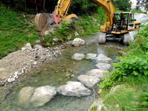
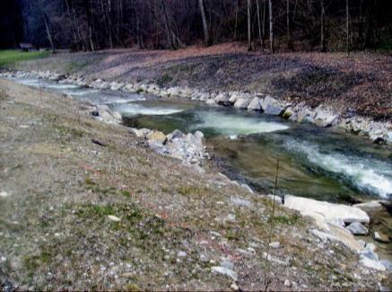
4 Instream River Training - «micro groins» Controlling erosion and deposition (channel stabilization) Creating morphodynamic diversity (habitats for fish etc.) Saving costs due to omittment of bank enhancement


5 Instream River Training: Monitoring channel stability Control without micro groins Channel with micro groins low minor water flood condition event after big flood low minor water flood condition event after big flood


6 Instream River Training - «meandering ramps» Fish migration - establishing continuity (replacing vertical drops etc.) Controlling erosion and deposition(channel stabilization) Creating morphologic diversity (habitats for fish etc.)
7 Instream River Training design rules Design rules meandering ramps river width: 10 m substrate: d mm ramp slope: 3% step spacing: 5-7 m design q: q 10 m 3 /sm Design rules micro groins relative submergence groin inclination groin spacing groin length required boulder size Sindelar (2011): Design of a Meandering Ramp, PhD Thesis, University of Technology Graz. Fish Monitoring Große Tulln River ( ) Complete migratory continuity Mende (2014): Naturnaher Uferschutz mit Lenkbuhnen - Grundlagen, Analytik und Bemessung, PhD Thesis, Technische Universität Braunschweig Monitoring Taverna River ( ) Ongoing ecological monitoring


 Rock Vanes (Dave Rosgen) (Rosgen,")

8 Instream River Training stream barbs & rock vanes Stream barbs & rock vanes Modification of flow by means of instream structures Only partly submerged, groin root level with top of bank transition to fully submerged state critical for banks Stream Barbs (USDA) Rock Vanes (Dave Rosgen) (Rosgen, 2001) (USDA, 2013) Courtesy of: University of Minnesota St. Anthony Falls (Khosronejad Laboratory et (2014) al., 2013)
9 Instream River Training outlook Outlook - Research Interaction of micro groins with river morphodynamics Effect of vortical structures on fish and macro invertrebrate Hybrid modeling (combined physical and numerical modeling) Meandering ramps for higher specific discharges and smaller substrate Outlook Application Installation of micro groins in a sharp bend in Thur River, Switzerland Continuation of monitoring program at Taverna River, Switzerland


10 Thank you for your attention Niels Werdenberg, Basler & Hofmann, Zollikofen Switzerland Matthias Mende, IUB Engineering, Bern Switzerland Christine Sindelar, IWHW, BOKU, Vienna Austria
Upper Mississippi River Basin Environmental Management Program Workshop
 Presentation to the Upper Mississippi River Basin Environmental Management Program Workshop by Michael Rodgers River Engineer US Army Corps of Engineers, St. Louis District August 17, 2007 Engineering
Laboratory Investigation of Submerged Vane Shapes Effect on River Banks Protection
 Australian Journal of Basic and Applied Sciences, 5(12): 1402-1407, 2011 ISSN 1991-8178 Laboratory Investigation of Submerged Vane Shapes Effect on River Banks Protection Touraj Samimi Behbahan Department
GENERAL SUMMARY BIG WOOD RIVER GEOMORPHIC ASSESSMENT BLAINE COUNTY, IDAHO
 GENERAL SUMMARY BIG WOOD RIVER GEOMORPHIC ASSESSMENT BLAINE COUNTY, IDAHO Prepared For Trout Unlimited 300 North Main Street, Hailey, Idaho, 83333 Prepared By P. O. Box 8578, 140 E. Broadway, Suite 23,
RAILWAYS AND FISH: HOW TO PROTECT AND ENHANCE FISH HABITAT VALUES AT STREAM CROSSINGS THROUGH PROJECT DESIGN AND CONSTRUCTION
 RAILWAYS AND FISH: HOW TO PROTECT AND ENHANCE FISH HABITAT VALUES AT STREAM CROSSINGS THROUGH PROJECT DESIGN AND CONSTRUCTION Rail Environment Conference November 2016 AGENDA Objective Background Benefits
CR AAO Bridge. Dead River Flood & Natural Channel Design. Mitch Koetje Water Resources Division UP District
 CR AAO Bridge Dead River Flood & Natural Channel Design Mitch Koetje Water Resources Division UP District Old County Road AAO Bridge Map courtesy of Marquette County Silver Lake Basin McClure Basin
Countermeasure Calculations and Design
 Countermeasure Calculations and Design Summarized from Bridge Scour and Stream Instability Countermeasures, Experience, Selection, and Design Guidance, Second Edition, Publication No. FHWA NHI 01-003,
Design of a Meandering Ramp located at the River Große Tulln
 River Flow 2010 - Dittrich, Koll, Aberle & Geisenhainer (eds) - 2010 Bundesanstalt für Wasserbau ISBN 978-3-939230-00-7 Design of a Meandering Ramp located at the River Große Tulln C. Sindelar & H. Knoblauch
Project (Project No. US-CA-62-2) Maintenance Inspection and Reports (Subtask 14.1) Inspection Report No.2
 Maintenance Inspection and Reports (Subtask 14.1) Inspection Report No.2") MEMORANDUM TO: FROM: Jim Well, Ducks Unlimited Mike Harvey, PhD, PG SUBJECT: M&T/ Llano Seco Fish Screen Project (Project No. US-CA-62-2) Maintenance Inspection and Reports (Subtask 14.1) Inspection Report
MEMORANDUM TO: FROM: Jim Well, Ducks Unlimited Mike Harvey, PhD, PG SUBJECT: M&T/ Llano Seco Fish Screen Project (Project No. US-CA-62-2) Maintenance Inspection and Reports (Subtask 14.1) Inspection Report
Why Stabilizing the Stream As-Is is Not Enough
 Why Stabilizing the Stream As-Is is Not Enough Several examples of alternatives to the County s design approach have been suggested. A common theme of these proposals is a less comprehensive effort focusing
Fluvial Driven Alluvial Fans
 Fluvial Driven Alluvial Fans Restoration Project Evaluations - Examples from the Russian and Napa River Watersheds Mia Docto Masters Thesis UC Berkeley 1. Basic Fan Description 2. Fluvial Driven Fan Characteristics
Channel Pattern. Channel Pattern, Meanders, and Confluences. Description of Channel Pattern. Bridge (2003)
") Channel Pattern Channel Pattern, Meanders, and Confluences Outline Description of channel pattern Alternate bars Channel pattern continua and evolution Controls of channel pattern Description of Channel
Channel Pattern Channel Pattern, Meanders, and Confluences Outline Description of channel pattern Alternate bars Channel pattern continua and evolution Controls of channel pattern Description of Channel
CFD Modeling for Structure Designs in Environmental Impacts Mitigation
 CFD Modeling for Structure Designs in Environmental Impacts Mitigation June 05 Navid Nekouee, Hugo Rodriguez and Steven Davie Environmental Impact Mitigation Design Savannah Harbor Expansion Project (SHEP)
Presented by: S. Ali Akbar Salehi Neyshabouri
 Presented by: S. Ali Akbar Salehi Neyshabouri MANAGEMENT (Aug. 18 20, 2008) 1 Sediment Deposition in Front of the Gate with Coarse Sediments MANAGEMENT (Aug. 18 20, 2008) 2 Functions of Intake Smooth water
Application of Fluvial Geomorphologic Techniques At Abandoned Mine Sites 1. David A. Greenfield 2 Dennis M. Palladino 3
 Application of Fluvial Geomorphologic Techniques At Abandoned Mine Sites 1 David A. Greenfield 2 Dennis M. Palladino 3 ABSTRACT Watersheds that have been severely impacted by mining can no longer transport
VELOCITY AND WATER DEPTH ANALYSIS ON DIFFERENT TYPES OF BLOCK RAMPS
 VELOCITY AND WATER DEPTH ANALYSIS ON DIFFERENT TYPES OF BLOCK RAMPS Markus J. Studer 1 and Anton J. Schleiss 2 1 Laboratory of Hydraulic Constructions (LCH), Ecole Polytechnique Fédérale de Lausanne (EPFL),
NATURE OF RIVERS B-1. Channel Function... ALLUVIAL FEATURES. ... to successfully carry sediment and water from the watershed. ...dissipate energy.
 1 2 Function... Sevier River... to successfully carry sediment and water from the watershed....dissipate energy. 3 ALLUVIAL FEATURES 4 CHANNEL DIMENSION The purpose of a stream is to carry water and sediment
FUTURE MEANDER BEND MIGRATION AND FLOODPLAIN DEVELOPMENT PATTERNS NEAR RIVER MILES 200 TO 191 OF THE SACRAMENTO RIVER PHASE III REPORT
 FUTURE MEANDER BEND MIGRATION AND FLOODPLAIN DEVELOPMENT PATTERNS NEAR RIVER MILES 200 TO 191 OF THE SACRAMENTO RIVER PHASE III REPORT Eric W. Larsen REPORT FOR DUCKS UNLIMITED March 31, 2006-1 - Contents
Important Copyright Information
 Important Copyright Information The following content is provided for educational purposes by the workshop presenter. This content may or may not have been peer reviewed. Information, opinions and recommendations
Practical Use of Deflectors in River Restoration Science Digest
 Practical Use of Deflectors in River Restoration Science Digest Aim This issue of Science Digest addresses deflectors as a practical restoration method and provides an overview of how this technique can
Appendix E Rosgen Classification
 Appendix E Stream Type s Using the morphometric parameters described above, stream reaches are classified into 7 major stream types (Aa+ through G) based on s (1996) criteria. The relevant stream classifications
Watershed Assessment of River Stability and Sediment Supply: Advancing the Science of Watershed Analysis
 Watershed Assessment of River Stability and Sediment Supply: Advancing the Science of Watershed Analysis 2009 MWEA Annual Conference Rob Myllyoja, CET rmyllyoja@hrc-engr.com Watershed Assessment of River
Riparian Assessment. Steps in the right direction... Drainage Basin/Watershed: Start by Thinking Big. Riparian Assessment vs.
 Riparian Assessment vs. Monitoring Riparian Assessment What is a healthy stream? Determine stream/riparian health Determine change or trend, especially in response to mgmt Classification = designation
Ms. A. Mormando's Class *
 8 th Grade Science Essential Standard: 8.E.1.1 Explain the structure of the hydrosphere including: Water distribution on Earth; Local river basin and water availability Stream - A stream is a body of water
Avoiding Geohazards in the Mid-Atlantic Highlands by Using Natural Stream Principles
 Avoiding Geohazards in the Mid-Atlantic Highlands by Using Natural Stream Principles J. Steven Kite, WVU Neal Carte, WVDOT Will Harman, Michael Baker Corp. Donald D. Gray, WVU Photo: W. Gillespie North
Assessment. Assessment
 2001 SPRINGBROOK CREEK RESTORATION - THREE YEAR POST-CONSTRUCTION REVIEW - Presented by Bruce Henderson and Andy Harris 2005 River Restoration Northwest Symposium Skamania Lodge, Washington www.hendersonlandservices.com
Fish Passage at Road Crossings
 Fish Passage at Road Crossings 1 Crossing Design Workshop Outline 1:00 to 2:00 Intro, Design Overview, Channel Width 2:00 to 2:15 Break 2:15 to 3:15 No-Slope, Stream Simulation Design 3:15 to 3:30 Break
Stream Geomorphology. Leslie A. Morrissey UVM July 25, 2012
 Stream Geomorphology Leslie A. Morrissey UVM July 25, 2012 What Functions do Healthy Streams Provide? Flood mitigation Water supply Water quality Sediment storage and transport Habitat Recreation Transportation
Sediment transport and river bed evolution
 1 Chapter 1 Sediment transport and river bed evolution 1.1 What is the sediment transport? What is the river bed evolution? System of the interaction between flow and river beds Rivers transport a variety
Hydraulics of bendway weirs
 River Basin Management IV 389 Hydraulics of bendway weirs C. Thornton 1, S. Abt 1, D. Baird 2 & R. Padilla 3 1 Colorado State University, Fort Collins, CO, USA 2 U.S. Bureau of Reclamation, Denver, CO,
Birch Creek Geomorphic Assessment and Action Plan
 Birch Creek Geomorphic Assessment and Action Plan Jim Webster Tim Hanrahan, PhD, CFM Jesse Schwartz, PhD Zach Hill January 22, 2015 White Eagle Grange This Project is a First Step in Strategy Planning
Perspectives on river restoration science, geomorphic processes, and channel stability
 Perspectives on river restoration science, geomorphic processes, and channel stability Stream Restoration Forum: Science and Regulatory Connections Andrew C. Wilcox Department of Geosciences University
Implementing a Project with 319 Funds: The Spring Brook Meander Project. Leslie A. Berns
 Implementing a Project with 319 Funds: The Spring Brook Meander Project Leslie A. Berns "...to acquire... and hold lands... for the purpose of protecting and preserving the flora, fauna and scenic beauties...
Natural Shoreline Landscapes on Michigan Inland Lakes
 Natural Shoreline Landscapes on Michigan Inland Lakes Excerpts from Chapters 2 and 3 Photo Photo by Jane by Jane Herbert Herbert Did you know? Twenty-four species of amphibians, 25 species of reptiles,
Business. Meteorologic monitoring. Field trip? Reader. Other?
 Business Meteorologic monitoring Field trip? Reader Other? Classification Streams Characterization Discharge measurements Why classify stream channels? Why Classify Stream Channels? Provides a common language
The how, why, and lessons learned
 The how, why, and lessons learned emulates natural river systems integrates fluvial processes over temporal and spatial scales of self-formed and self-maintained natural rivers reestablish the physical,
Geomorphology Studies
 Geomorphology Studies Technical Workgroup Meeting February 14, 2012 Prepared by: Tetra Tech Prepared for: Alaska Energy Authority Overall Goal Geomorphology Studies Two studies Geomorphology Study (RSP
Appendix F Channel Grade Control Structures
 Stream Simulation Appendix F Channel Grade Control Structures This appendix briefly describes permanent grade control structures that are sometimes needed in the upstream and/or downstream reaches adjacent
Domino Effect of River Training in Large Sand-Bed Braiding Rivers
 6 th International Conference on Structural Engineering and Construction Management 2015, Kandy, Sri Lanka, 11 th -13 th December 2015 SECM/15/176 Domino Effect of River Training in Large Sand-Bed Braiding
Probabilistic Evaluation of a Meandering Low-Flow Channel. February 24 th, UMSRS
 Probabilistic Evaluation of a Meandering Low-Flow Channel February 24 th, 2014 2014 UMSRS 1 2 acknowledgments Low- Flow Channel (LFC) overview Proposed Diversion Channel collects runoff from: The Rush
Session 1 Healthy Streams Stream Hydraulics Natural Channel Design
 Session 1 Healthy Streams Stream Hydraulics Natural Channel Design Bill Brant Heart of America Flyfishers Black & Veatch Kansas City, MO February 21, 2014 http://www.bobswebspace.com Audience? What do
Page 1. Name:
 Name: 1) Which event is the best example of erosion? dissolving of rock particles on a limestone gravestone by acid rain breaking apart of shale as a result of water freezing in a crack rolling of a pebble
Addressing the Impact of Road-Stream Crossing Structures on the Movement of Aquatic Organisms
 Scott Jackson University of Massachusetts Amherst Addressing the Impact of Road-Stream Crossing Structures on the Movement of Aquatic Organisms Dams Sub-standard Culverts Excessive Velocities Inlet Drop
Hydrographical Surveying of the Subaqueous Delta Plain of the River Rhine at Lake Constance
 Hydrographical Surveying of the Subaqueous Delta Plain of the River Rhine at Lake Constance Erwin Heine Institute of Surveying BOKU University Vienna, AUSTRIA Content Introduction Universität für Bodenkultur
Longitudinal dams as an alternative to wing dikes in river engineering. Fredrik Huthoff
 Longitudinal dams as an alternative to wing dikes in river engineering Fredrik Huthoff Contents Introduction Why consider longitudinal dams? Room for the river in the Netherlands The pilot study The Dutch
Field Methods to Determine/ Verify Bankfull Elevation, XS Area & Discharge
 Module # 6 Field Methods to Determine/ Verify Bankfull Elevation, XS Area & Discharge Iowa s River Restoration Toolbox Level 1 / Base Training Overview of Basic Field Data Collection Site Map Cross Sections
Case Study 2: Twenty-mile Creek Rock Fords
 Case Study : Twenty-mile Creek Rock Fords Location Crossing Description Washington. Okanagan National Forest. Methow Valley Ranger District. Chewuch river basin, East Chewuch Road. The Twenty-mile Creek
Environmental Value. Low Moderate High
 Boulder Clusters by Craig Fischenich and Rebecca Seal February Complexity Environmental Value Cost Low Moderate High Low Moderate High Low Moderate High OVERVIEW Boulder clusters are groups of large rocks
Erosion Surface Water. moving, transporting, and depositing sediment.
 + Erosion Surface Water moving, transporting, and depositing sediment. + Surface Water 2 Water from rainfall can hit Earth s surface and do a number of things: Slowly soak into the ground: Infiltration
Step 5: Channel Bed and Planform Changes
 Step 5: Channel Bed and Planform Changes When disturbed, streams go through a series of adjustments to regain equilibrium with the flow and sediment supply of their watersheds. These adjustments often
Tom Ballestero University of New Hampshire. 1 May 2013
 Tom Ballestero University of New Hampshire 1 May 2013 1 Hydrology 2 Basic Hydrology Low flows most common Flows that fill the stream to the banks and higher are much less common Filling the stream to the
Wetland & Floodplain Functional Assessments and Mapping To Protect and Restore Riverine Systems in Vermont. Mike Kline and Laura Lapierre Vermont DEC
 Wetland & Floodplain Functional Assessments and Mapping To Protect and Restore Riverine Systems in Vermont Mike Kline and Laura Lapierre Vermont DEC NWI+ Hydro-Geomorphic Characterization of Wetlands and
Carmel River Bank Stabilization at Rancho San Carlos Road Project Description and Work Plan March 2018
 Carmel River Bank Stabilization at Rancho San Carlos Road Project Description and Work Plan March 2018 EXISTING CONDITION The proposed Carmel River Bank Stabilization at Rancho San Carlos Road Project
ADDRESSING GEOMORPHIC AND HYDRAULIC CONTROLS IN OFF-CHANNEL HABITAT DESIGN
 ADDRESSING GEOMORPHIC AND HYDRAULIC CONTROLS IN OFF-CHANNEL HABITAT DESIGN Conor Shea - Hydrologist U.S. Fish and Wildlife Service Conservation Partnerships Program Arcata, CA Learning Objectives Examine
Island Design. UMRS EMP Regional Workshop. Presentation for the
 Island Design Presentation for the UMRS EMP Regional Workshop by Jon Hendrickson Hydraulic Engineer Regional Technical Specialist, Water Quality and Habitat Restoration August 17 19, 2005 Project Delivery
Quasi-three dimensional computations for flows and bed variations in curved channel with gently sloped outer bank
 River Sedimentation Wieprecht et al. (Eds) 2017 Taylor & Francis Group, London, ISBN 978-1-138-02945-3 Quasi-three dimensional computations for flows and bed variations in curved channel with gently sloped
BZ471, Steam Biology & Ecology Exam
 BZ471, Eam1, p.1 BZ471, Steam Biology & Ecology Eam Name Multiple choice When benthic organisms enter the water column with a regular diel periodicity: a) catastrophic drift b) behavioral drift c) constant
Strategies for managing sediment in dams. Iwona Conlan Consultant to IKMP, MRCS
 Strategies for managing sediment in dams Iwona Conlan Consultant to IKMP, MRCS 1 Sediment trapping by dams Active storage capacity Dead storage coarse material (bed load) Fine materials (suspension) Francis
ON SOME MOUNTAIN STREAMS AND RIVERS MORPHODYNAMICAL PARAMETER CHARACTERISTICS USING FIELD AND NUMERICAL MODELING
 Agricultural University of Krakow, Department of Water Engineering Wojciech Bartnik, Leszek Książek, Artur Radecki-Pawlik, Andrzej Strużyński ON SOME MOUNTAIN STREAMS AND RIVERS MORPHODYNAMICAL PARAMETER
Stream Classification
 Stream Classification Why Classify Streams? Communication Tool Describe Existing Conditions & Trends Describe Restoration Goals Research Tool Morphologic Stream Classification Systems Schumm (1977) Alluvial
Aquifer an underground zone or layer of sand, gravel, or porous rock that is saturated with water.
 Aggradation raising of the streambed by deposition that occurs when the energy of the water flowing through a stream reach is insufficient to transport sediment conveyed from upstream. Alluvium a general
Limitation to qualitative stability indicators. the real world is a continuum, not a dichotomy ~ 100 % 30 % ~ 100 % ~ 40 %
 Stream Stability Assessment & BEHI Surveys Joe Rathbun MDEQ Water Resources Division rathbunj@michigan.gov 517--373 517 373--8868 Stability Stream can transport its water and sediment inputs without changing
APPENDIX E: Crystal River Hydraulic Modeling Report
 APPENDIX E: Crystal River Hydraulic Modeling Report Crystal River Hydraulic Modeling Report Garfield and Pitkin Counties, Colorado Report prepared for: Lotic Hydrological PO Box 1524 Carbondale, CO 81623
SCOPE OF PRESENTATION STREAM DYNAMICS, CHANNEL RESTORATION PLANS, & SEDIMENT TRANSPORT ANALYSES IN RELATION TO RESTORATION PLANS
 DESIGN METHODS B: SEDIMENT TRANSPORT PROCESSES FOR STREAM RESTORATION DESIGN PETER KLINGEMAN OREGON STATE UNIVERSITY CIVIL ENGINEERING DEPT., CORVALLIS 2 ND ANNUAL NORTHWEST STREAM RESTORATION DESIGN SYMPOSIUM
Upper Truckee River Restoration Lake Tahoe, California Presented by Brendan Belby Sacramento, California
 Upper Truckee River Restoration Lake Tahoe, California Presented by Brendan Belby Sacramento, California Mike Rudd (Project Manager), Charley Miller & Chad Krofta Declines in Tahoe s Water Clarity The
C. STUDENT FIELD DATA SHEETS
 C. STUDENT FIELD DATA SHEETS Student Name Date Time Stream Location Parameter to find Your Group s Results Units trial trial average Transparency cm Water Temperature Air Temperature Weather N sunny N
Forest Service AOP Meeting Objectives of Stream Simulation: Examples and Talking Points
 Forest Service AOP Meeting Objectives of Stream Simulation: Examples and Talking Points Traci Sylte, P.E. Hydrology/Fluvial Geomorphology Lolo National Forest Is It True? Are Road Crossings a Dam with
Water Erosion (pages )
") Water Erosion (pages 272 281) Runoff and Erosion (pages 273 274) Key Concept: Moving water is the major agent of the erosion that has shaped Earth s land surface. Falling raindrops can loosen and pick
Water Erosion (pages 272 281) Runoff and Erosion (pages 273 274) Key Concept: Moving water is the major agent of the erosion that has shaped Earth s land surface. Falling raindrops can loosen and pick
New Approaches to Restoring NH s Rivers Natural Channel Design and Dam Removal
 NHACC Annual Meeting 2012 New Approaches to Restoring NH s Rivers Natural Channel Design and Dam Removal Peter J. Walker CROOKED STREAMS are a menace to life and crops in the areas bordering on their banks.
Field Trip Number One. By: Pat Dryer. Geography 360
 Field Trip Number One By: Pat Dryer Geography 360 Table of Contents Introduction. Page 1 Stop One... Page 2 Stop Two... Page 4 Stop Three... Page 5 Stop Four... Page 7 Bibliography Page 8 Campus Map Source:
Stream Restoration Series Single-Arm Vane
 Fact Sheet Number 2 Stream Restoration Series Single-Arm Vane Authors: E.L. Hickman and T.M. Thompson, Biological Systems Engineering ALTERNATE NAMES: (single-arm) rock vane, (single-arm) log vane, singlewing
Do you think sediment transport is a concern?
 STREAM RESTORATION FRAMEWORK AND SEDIMENT TRANSPORT BASICS Pete Klingeman 1 What is Your Restoration Project Like? k? Do you think sediment transport is a concern? East Fork Lewis River, WA Tidal creek,
FRESH SURFACE WATER Vol. III - River Navigation and Associated Structures - D. M. Admiraal, M. H. García RIVER NAVIGATION AND ASSOCIATED STRUCTURES
 RIVER NAVIGATION AND ASSOCIATED STRUCTURES D. M. Admiraal Department of Civil Engineering, University of Nebraska, USA M. H. García Department of Civil and Environmental Engineering, University of Illinois
Instream Erosion Control General
 Instream Erosion Control General EROSION CONTROL TECHNIQUES Revegetation Temperate Climates Short-Term Non Vegetation Wet Tropics Long-Term Weed Control [1] Semi-Arid Zones Permanent [1] Weed control attributes
Water flowing in the stream can move sediments along the stream channel because of an exchange of energy from the
 1. Base your answer(s) to the following question(s) on the Earth Science Reference Tables, the diagram below, and your knowledge of Earth science. The diagram represents a laboratory stream table. Water
MEASUREMENT OF 3D FLOW FIELD IN A 90 BEND WITH ULTRASONIC DOPPLER VELOCITY PROFILER
 MEASUREMENT OF 3D FLOW FIELD IN A 90 BEND WITH ULTRASONIC DOPPLER VELOCITY PROFILER Daniel S. Hersberger 1 1 Research associate, Laboratory of Hydraulic Constructions (LCH), Swiss Federal Institute of
Stream Restoration and Environmental River Mechanics. Objectives. Pierre Y. Julien. 1. Peligre Dam in Haiti (deforestation)
") Stream Restoration and Environmental River Mechanics Pierre Y. Julien Malaysia 2004 Objectives Brief overview of environmental river mechanics and stream restoration: 1. Typical problems in environmental
Stream Restoration and Environmental River Mechanics Pierre Y. Julien Malaysia 2004 Objectives Brief overview of environmental river mechanics and stream restoration: 1. Typical problems in environmental
27. Running Water I (p ; )
") 27. Running Water I (p. 424-436; 440-444) Hydrosphere How much of the Earth s surface is covered by water? Earth's water is collectively called the and is stored in a number of so-called as follows: 1.
27. Running Water I (p. 424-436; 440-444) Hydrosphere How much of the Earth s surface is covered by water? Earth's water is collectively called the and is stored in a number of so-called as follows: 1.
Bank stabilization by redirective structures on the Santa Clara River, Ventura County, CA
 116 Alex Yescas Senior Water Resources Engineer Atkins North America Bank stabilization by redirective structures on the Santa Clara River, Ventura County, CA Abstract The Santa Clara River is one of the
Physical modeling to guide river restoration projects: An Overview
 Physical modeling to guide river restoration projects: An Overview Scott Dusterhoff¹, Leonard Sklar², William Dietrich³, Frank Ligon¹, Yantao Cui¹, and Peter Downs¹ ¹Stillwater Sciences, 2855 Telegraph
Rivers T. Perron
 1 Rivers T. Perron 12.001 After our discussions of large-scale topography, how we represent topography in maps, and how topography interacts with geologic structures, you should be frothing at the mouth
Teacher s Pack Key Stage 3 GEOGRAPHY
 Teacher s Pack Key Stage 3 GEOGRAPHY Geography Key Stage 3 Fieldwork Worksheet Rivers: 1. Is the water fresh or salty? (test its resistance or specific gravity) 2. Do you know where the water is coming
Analysis of Cost-Effective Rehabilitation: Principles and Tools for Reducing Uncertainty in Design
 Analysis of Cost-Effective Rehabilitation: Principles and Tools for Reducing Uncertainty in Design Natasha Bankhead and Andrew Simon Cardno ENTRIX, Oxford, MS natasha.bankhead@cardno.com Often the Questions
Fact sheet: Glacial rivers (all Europe)
") Fact sheet: Glacial rivers (all Europe) General description Valleyplanform Hydrology and The valley form varies from a gorge to a V-shaped valley and the single-thread channel is mainly characterized by
Fact sheet: Glacial rivers (all Europe) General description Valleyplanform Hydrology and The valley form varies from a gorge to a V-shaped valley and the single-thread channel is mainly characterized by
River Nith restoration, cbec UK Ltd, October 2013 APPENDIX A
 APPENDIX A FLUVIAL AUDIT METHOD STATEMENT Fluvial Audit Methodology INTRODUCTION The procedure used to characterize the geomorphic and sedimentary regimes of the River Till is an adaptation of the Fluvial
Scheepvaart en ecologische doelstellingen
 Scheepvaart en ecologische doelstellingen Margriet Schoor 25 April 2008 The Rhine Delta Rotterdam 2/3 1/3 Scheepvaart en ecologische doelstellingen 2 Germany Navigation on the Rhine Busiest river in Europe
Dams, sediment, and channel changes and why you should care
 Dams, sediment, and channel changes and why you should care Gordon E. Grant USDA Forest Service PNW Research Station Corvallis, Oregon Dam effects on river regimes FLOW (Q) SEDIMENT (Qs) TEMP CHEMISTRY
Licca Liber - the free Lech
 Licca Liber - the free Lech Source: W. Schilling WWA Donauwörth The river Lech an overview Hydrography / Hydrology catchment area 4000 km² Length 256 km Delta H 1100 m Slope Ø 0,4 % discharge in Augsburg
BANK PROTECTION AT THE OUTER SIDE OF CURVED CHANNELS BY AN UNDULATED MACROROUGH CONCRETE WALL
 4 th IAHR International Symposium on Hydraulic Structures, 9-11 February 2012, Porto, Portugal, ISBN: 978-989-8509-01-7 BANK PROTECTION AT THE OUTER SIDE OF CURVED CHANNELS BY AN UNDULATED MACROROUGH CONCRETE
NUMERICAL SIMULATION OF EROSION PROCESSES ON CROSSBAR BLOCK RAMPS
 E-proceedings of the 36 th IAHR World Congress NUMERICAL SIMULATION OF EROSION PROCESSES ON CROSSBAR BLOCK RAMPS MARIO OERTEL (1), JAN P. BALMES (2), DANIEL B. BUNG (3) (1) Hydraulic Engineering Section,
Garner State Park Pavilion Preservation Study
 D4 Garner State Park Pavilion Preservation Study Presented by Andy Johnston, PE, CPESC, CFM Halff Associates, Inc. Austin Mark Winford, RA, LEED AP Texas Parks and Wildlife Department, Austin Location
Working with Natural Stream Systems
 Working with Natural Stream Systems Graydon Dutcher Delaware County Soil & Water Conservation District Stream Corridor Management Program Tropical Storm Sandy October 29,2012 What is a Watershed?
Morphodynamic effects of stone and wooden groynes in a restored river reach
 Morphodynamic effects of stone and wooden groynes in a restored river reach Bahaeldeen Zaid 1,*, Paride Nardone 1, Michael Nones 2, Christoph Gerstgraser 3 and Katinka Koll 1 1 Leichtweiß-Institute for
GTU. Shantilal Shah Engineering College, Bhavnagar
 GTU Shantilal Shah Engineering College, Bhavnagar 2 Around 40,000 large reservoirs worldwide used for water supply, power generation, flood control etc. About 1 % of the total storage volume is lost annually
Landscape Development
 Landscape Development Slopes Dominate Natural Landscapes Created by the interplay of tectonic and igneous activity and gradation Deformation and uplift Volcanic activity Agents of gradation Mass wasting
mountain rivers fixed channel boundaries (bedrock banks and bed) high transport capacity low storage input output
 high transport capacity low storage input output") mountain rivers fixed channel boundaries (bedrock banks and bed) high transport capacity low storage input output strong interaction between streams & hillslopes Sediment Budgets for Mountain Rivers Little
mountain rivers fixed channel boundaries (bedrock banks and bed) high transport capacity low storage input output strong interaction between streams & hillslopes Sediment Budgets for Mountain Rivers Little
-- Lessons from a successful salmon stream and estuary relocation on Gravina Island
 Re-inventing Government Creek -- Lessons from a successful salmon stream and estuary relocation on Gravina Island Jon Houghton, Ph.D. and Derek Ormerod, M.S., P.E. - Pentec Environmental/Hart Crowser,
Environmental Geology Chapter 9 Rivers and Flooding
 Environmental Geology Chapter 9 Rivers and Flooding Flooding in Pakistan 2010-1600 killed/20000 affected The hydrologic cycle is powered by the Sun The cycle includes evaporation, precipitation, infiltration,
HAW CREEK, PIKE COUNTY, MISSOURI-TRIB TO SALT RIVER ERODING STREAM THREATHENING COUNTY ROAD #107, FOURTEEN FT TALL ERODING BANK WITHIN 4 FT OF THE
 HAW CREEK, PIKE COUNTY, MISSOURI-TRIB TO SALT RIVER ERODING STREAM THREATHENING COUNTY ROAD #107, FOURTEEN FT TALL ERODING BANK WITHIN 4 FT OF THE ROAD, PROJECT CONSTRUCTED IN 1 DAY, MARCH 10, 2009 BY
Ch 10 Deposition Practice Questions
 1. Base your answer to the following question on the data table below. Six identical cylinders, A through F, were filled with equal volumes of sorted spherical particles. The data table shows the particle
Long Valley Meadow Restoration Project
 Long Valley Meadow Restoration Project USDA Forest Service Mogollon Rim Ranger District Coconino National Forest Coconino County, Arizona T13N, R9E, Section 12 and T13N, R10E, Sections 6 and 7 Gila and