Gareth J Hearn. Engineering challenges for sustainable development in mountainous areas. Sustainable Resource Development in the Himalaya
|
|
|
- Aron Hall
- 5 years ago
- Views:
Transcription
1 Sustainable Resource Development in the Himalaya Engineering challenges for sustainable development in mountainous areas Gareth J Hearn Hearn Geoserve Ltd, UK Formerly with URS, Scott Wilson Ltd Wednesday, 25 June 2014

2 Contents of this Presentation Illustrate engineering challenges for infrastructure development in mountain regions Summarise terrain evaluation and geo-hazard assessment techniques for meeting these challenges Make recommendations for a sustainable engineering approach Conclusions & the way forward Ethiopian Highlands, up to 4,500m

3 What is Meant by Engineering in the Context of Sustainable Mountain Development? Transport infrastructure, mostly roads, but also railways Alignments Excavations Fill slopes Retaining walls Tunnels River crossings Drainage Buildings Hydropower schemes Power transmission Mining Water supply infrastructure Telecommunications This presentation focuses on roads, but much of the discussion is equally important to other infrastructure Near Gangtok, Sikkim
4 Main Challenges Difficult and extreme terrain Complex and variable ground conditions (geological/geotechnical) Extremes of climate: snow, ice, freeze-thaw cycles, intense and prolonged rainfall & climate change effects Severe geo-hazards, depending on topography, climate and geology: glacial and landslide-dammed lake outbursts snow avalanches seismicity landslides, rock falls and rock avalanches meteorological floods debris flows erosion/scour and aggradation aeolian hazards Complex land use interactions and land use change effects Environmental and social compatibility Developing a sustainable outcome


5 Difficult and Extreme Terrain ArunAccess Road, Nepal Lake SarezAccess Road, Tajikistan


6 Complex and Variable Ground Conditions Shagon-Zigar Road, Tajikistan


7 Extremes of Climate & Climate Change Effects


8 Severe Geo-Hazards: Seismicity WenchuanEarthquake, Sichuan Province, May 2008, Ms 8.0, Depth 14 km


9 Severe Geo-hazards: Landslides Baipaza Landslide into Baipaza HEP reservoir, Tajikistan Typhoon Ondoy, Halsema Highway, Philippines, 2009


10 Severe Geo-hazards: Floods Meteororological Floods, Nepal & Tajikistan Glacial and Landslide Lake Outbursts, Kyrgyz Kutman Kul Landslide Dam, Kyrgyzstan 2840m asl 75 million m3 of landslide 4 million m3 of lake Uranium mining, towns and transport infrastructure downstream


11 Severe Geo-hazards: Erosion and Aggradation Halsema Highway, Philippines Prithvi Highway, Nepal


12 Land Use and Climate Change Effects Yesterday, the students emphasised the role of deforestation. If deforestation gives way to well-managed land use then the effects can be minimised Where leaky irrigation canals are constructed on marginally stable or erodible slopes then instability can be triggered or exacerbated However, deep-seated landslides often occur regardless of the occupying land use


13 Flood envelopes based on historical floods tend to be conservative in their estimate, although large floods may be becoming more frequent due to land use and climate change, or their frequency may have been underestimated from short term records. Hearn, GJ Principles of low cost road engineering in mountainous regions. Overseas Road Note 16, Transport Research Laboratory, UK

14 Terrain and Geo-hazard Assessment for Sustainable Engineering The performance of engineering infrastructure in mountains is usually determined mostly by: The stability of earthworks The impact of landslides Cross drainage erosion Sediment transport The impacts of floods Seismicity may impact bridges, viaducts and retaining structures but it is often its effect on earthworks stability and the triggering or reactivation of landslides that is most significant The focus of much of the remainder of this presentation will be on landslide, slope stability and flood-related hazards
15 What are the Fundamental Requirements? Make maximum use of all available data Make maximum use of analytical techniques Utilise the Observational Approach and always ensure that desk study interpretation is supported by field observations Consult with local expertise and communities Develop a geo-model for the project area Learn from past successes and failures
16 In many mountainous parts of the world the following conditions often combine to create worst-case scenarios for transport infrastructure: Terrain/Geo-hazard Constraints Steep and complex terrain Tectonically disturbed rocks Adverse structures Deep weathering profiles Earthquakes and landslides High groundwater and soil saturation brought about by intense or prolonged rain Rivers prone to frequent flooding, channel scour and shifting channels Resource Constraints Limited available information concerning ground conditions and geo-hazards Limited economic and technical resources to investigate ground conditions Limited capital resources with which to prevent or mitigate landslides
17 Terrain and Geo-hazard Assessment for Sustainable Engineering Remote sensing Satellite interpretation Aerial photograph interpretation Airborne imagery, mainly LiDAR Hazard mapping Landscape modelling techniques Field reconnaissance mapping Engineering geological mapping Ground investigation, slope analysis, monitoring and design
18 Satellite Imagery for Topographic Mapping From James Mitchell
19 Satellite Imagery for Terrain and Environmental Interpretation From James Mitchell


20 Use of Air-borne LiDAR imagery for DEM, Route Selection & Hazard Mapping


21

22 Air Photograph Interpretation Dharan-Dhankuta Road, Nepal


23 ArunAccess Road, Nepal Landscape Modelling


24 Landscape Modelling Drawn by G Pettifer Blue Nile River Crossing, Ethiopia


25 Landslide Susceptibility Mapping Dharan-Dhankuta Road, Nepal
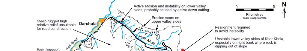

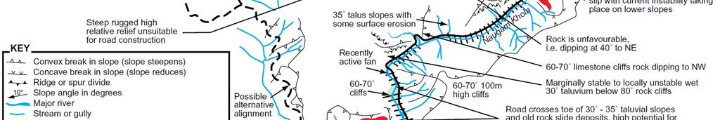
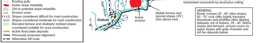
26 Engineering Geological Reconnaissance Mapping Baitadi-Darchula Road, Nepal

27 Engineering Geological Mapping for earthworks design Blue Nile River Crossing, Ethiopia


28 Avoiding Sensitive Habitats Black areas Level 1 biodiversity value Grey areas Level 2 biodiversity value Broken red line areas approxmine boundaries Light brown areas approxproposed waste dumps Blue areas sedimentation ponds Liberia, courtesy ArcelorMittal

29 Engineering Necessity or Engineering Futility?


30 Harmonizing the Engineering with Landscape Constraints and Service Level Requirements of the Infrastructure Darjeeling-Teesta Bridge, India Shagon-Zigar Road, Tajikistan Arterial Roads Green Roads

31 The Building Blocks of Sustainable and Responsible Engineering Engineering Imperatives Design the engineering to suite the need Avoid geo-hazards in route selection Avoid excessive earthworks in route selection Cut slopes according to the strength of materials exposed Try to balance cut and fill Maximise drainage crossings, i.e. minimise drainage concentration Do not construct anything that cannot be maintained Environmental Imperatives Avoid areas of ecological or cultural significance Minimise spoil, i.e. maximise reuse of materials Dispose of spoil in safe areas Maximise roadside replanting schemes Minimise adverse effects on adjacent land uses and compensate accordingly


32 Rock Slope Stabilisation and Rock Fall Control

33 Earthworks Design and Soil Slope Stabilisation

34 Its Knowing What to do Where which is of Greatest Importance


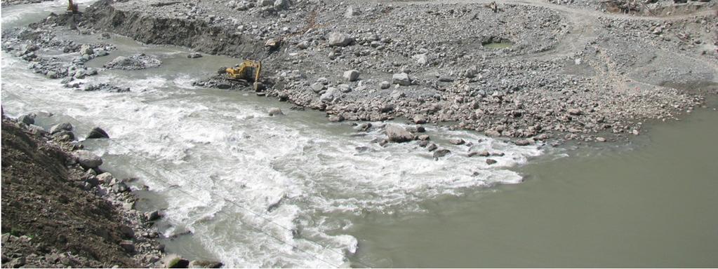
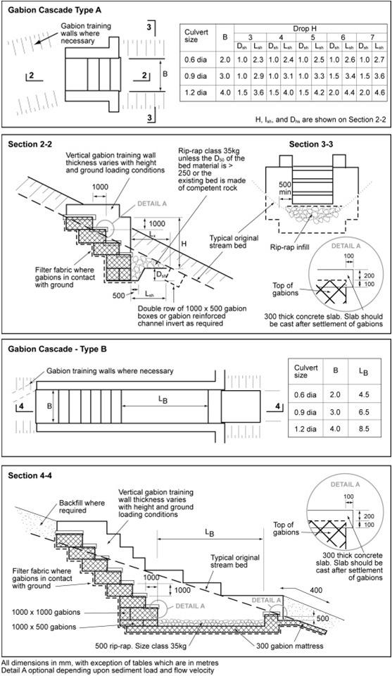
35 Flood Hazard Mitigation

36 Engineering Erosion Control


37 Community-Based/Participatory Erosion Control Bhutan Nepal Laos NB there has been an erosion control centre in Dehra Dun since 1974


38 Construction Materials and Methods Local Vs Imported Materials Labour-Based Vs Machine- Intensive Calcrete Otta Seal, Mozambique DFID-Funded AFCAP and SEACAP Research


39 Choose the Right Solution for the Prevailing Topography and Ground Conditions


40 Sometimes it Can be Hard to Learn from our Mistakes Change in Direction Change in outlook


41 Further information on these techniques and designs for mountain roads can be found in: Geological Society of London Special Publication No 24
42 Conclusions and Way Forward 1. Read the landscape the landscape is made up of geology, geomorphology and land use, & geo-hazards past, present & potentially future Prof Owen 2. Utilise all desk study data (including RS) for geological, geo-hazard, topographic and environmental data 3. Undertake field surveys & community liaison to collection site specific information and local knowledge Mr Rinjin Jora Hon Minister UDLUB 4. Locate and design infrastructure according to 1-3 and according to service requirements, i.e. do not over-design or under-design 5. Do not reinvent the wheel: learn from the wider engineering & engineering geological community from past successes & failures & innovate accordingly 6. But, do not ignore the wheel! 8. Maximise the use of local materials, local knowledge & local skills, and maximise community participation Prof Dominelli 9. Avoid environmentally sensitive areas and adopt environmental conservation practices Dr Worah 10. Only construct what can be maintained, i.e. promote sustainable engineering


43 Thank You
Need of Proper Development in Hilly Urban Areas to Avoid
 Need of Proper Development in Hilly Urban Areas to Avoid Landslide Hazard Dr. Arvind Phukan, P.E. Cosultant/Former Professor of Civil Engineering University of Alaska, Anchorage, USA RI District Governor
How to manage risk through integrated geohazard assessment. Prof. John M. Reynolds Reynolds International Ltd, Mold, UK
 How to manage risk through integrated geohazard assessment Prof. John M. Reynolds Reynolds International Ltd, Mold, UK Talk outline Introduction Types of disasters within the Himalayas Integrated Geohazard
Using Weather and Climate Information for Landslide Prevention and Mitigation
 Using Weather and Climate Information for Landslide Prevention and Mitigation Professor Roy C. Sidle Disaster Prevention Research Institute Kyoto University, Japan International Workshop on Climate and
Surface Processes Focus on Mass Wasting (Chapter 10)
") Surface Processes Focus on Mass Wasting (Chapter 10) 1. What is the distinction between weathering, mass wasting, and erosion? 2. What is the controlling force in mass wasting? What force provides resistance?
Surface Processes Focus on Mass Wasting (Chapter 10) 1. What is the distinction between weathering, mass wasting, and erosion? 2. What is the controlling force in mass wasting? What force provides resistance?
Prof. B V S Viswanadham, Department of Civil Engineering, IIT Bombay
 19 Module 5: Lecture -1 on Stability of Slopes Contents Stability analysis of a slope and finding critical slip surface; Sudden Draw down condition, effective stress and total stress analysis; Seismic
GENERAL. CHAPTER 1 BACKGROUND AND PURPOSE OF THE GUIDELINES Background of the Guidelines Purpose of the Guidelines...
 GENERAL CHAPTER 1 BACKGROUND AND PURPOSE OF THE GUIDELINES... 1 1.1 Background of the Guidelines... 1 1.2 Purpose of the Guidelines... 3 CHAPTER 2 APPLICATION OF THE GUIDELINES... 3 2.1 Potential Users
ENVIRONMENTAL GEOSCIENCE UNIFORM SYLLABUS
 ENVIRONMENTAL GEOSCIENCE UNIFORM SYLLABUS The Association of Professional Engineers and Geoscientists of the Province of British Columbia Note: 1. This Syllabus May Be Subject To Change 2. These Courses
The Effects of Hydraulic Structures on Streams Prone to Bank Erosion in an Intense Flood Event: A Case Study from Eastern Hokkaido
 Symposium Proceedings of the INTERPRAENENT 2018 in the Pacific Rim The Effects of Hydraulic Structures on Streams Prone to Bank Erosion in an Intense Flood Event: A Case Study from Eastern Hokkaido Daisuke
OIKOS > landslide > mechanism >predisposing causes
 predisposing causes and trigger OIKOS > landslide > mechanism >predisposing causes Landslides are events that occur in space and time. As such, it is usually possible to identify both one or more landslide
24.0 Mineral Extraction
 Chapter 24 - Mineral Extraction 24.0 Mineral Extraction 24.1 Introduction Apart from gravel, sand, rock, limestone and salt extraction in relatively small quantities mineral extraction is not a strong
Mass Wasting. Revisit: Erosion, Transportation, and Deposition
 Mass Wasting Revisit: Erosion, Transportation, and Deposition While landslides are a normal part of erosion and surface processes, they can be very destructive to life and property! - Mass wasting: downslope
UGRC 144 Science and Technology in Our Lives/Geohazards
 UGRC 144 Science and Technology in Our Lives/Geohazards Flood and Flood Hazards Dr. Patrick Asamoah Sakyi Department of Earth Science, UG, Legon College of Education School of Continuing and Distance Education
Earthquake hazards. Aims 1. To know how hazards are classified 2. To be able to explain how the hazards occur 3. To be able to rank order hazards
 Earthquake hazards Aims 1. To know how hazards are classified 2. To be able to explain how the hazards occur 3. To be able to rank order hazards Types of hazard Primary A direct result of the earthquake
Geohazards in the Himalaya GEOL 3000 (3 Credits / 45 class hours)
") Geohazards in the Himalaya GEOL 3000 (3 Credits / 45 class hours) SIT Study Abroad Program: Nepal: Geoscience in the Himalaya PLEASE NOTE: This syllabus represents a recent term. Because courses develop
Geohazards in the Himalaya GEOL 3000 (3 Credits / 45 class hours) SIT Study Abroad Program: Nepal: Geoscience in the Himalaya PLEASE NOTE: This syllabus represents a recent term. Because courses develop
Debris flow: categories, characteristics, hazard assessment, mitigation measures. Hariklia D. SKILODIMOU, George D. BATHRELLOS
 Debris flow: categories, characteristics, hazard assessment, mitigation measures Hariklia D. SKILODIMOU, George D. BATHRELLOS Natural hazards: physical phenomena, active in geological time capable of producing
Geomorphology for Engineers
 Geomorphology for Engineers Edited by P. G. Fookes, E. M. Lee and G. Milligan Whittles Publishing CRC PRESS Contents Foreword Preface Dedication Biographies 1. Introduction to Engineering Geomorphology
ENGINEERING GEOLOGY "Underground, Overground "
 Edinburgh Career and Industry Day WELCOME 2017 www.geolsoc.org.uk ENGINEERING GEOLOGY "Underground, Overground " Katerina Braun CGeol EurGeol MSc BSc (Hons) FGS Chris Jack CGeol EurGeol MSc BSc (Hons)
SLOPE PROCESSES, LANDSLIDES, AND SUBSIDENCE
 CHAPTER 9 SLOPE PROCESSES, LANDSLIDES, AND SUBSIDENCE La Conchita slide January 10, 2005 Triggered by heavy rainfall, reactivation along an older landslide surface (35,000 years ago, 6000 years ago, and
APPLICATION OF REMOTE SENSING & GIS ON LANDSLIDE HAZARD ZONE IDENTIFICATION & MANAGEMENT
 APPLICATION OF REMOTE SENSING & GIS ON LANDSLIDE HAZARD ZONE IDENTIFICATION & MANAGEMENT PRESENTED BY SUPRITI PRAMANIK M.TECH IN ENVIRONMENTAL SCIENCE AND TECHNOLOGY NIT,DURGAPUR 25-04-2015 1 INTRODUCTION
Physical Geography: Patterns, Processes, and Interactions, Grade 11, University/College Expectations
 Geographic Foundations: Space and Systems SSV.01 explain major theories of the origin and internal structure of the earth; Page 1 SSV.02 demonstrate an understanding of the principal features of the earth
ENGINEERING HYDROLOGY
 ENGINEERING HYDROLOGY Prof. Rajesh Bhagat Asst. Professor Civil Engineering Department Yeshwantrao Chavan College Of Engineering Nagpur B. E. (Civil Engg.) M. Tech. (Enviro. Engg.) GCOE, Amravati VNIT,
Natural hazards in Glenorchy Summary Report May 2010
 Natural hazards in Glenorchy Summary Report May 2010 Contents Glenorchy s hazardscape Environment setting Flood hazard Earthquakes and seismic hazards Hazards Mass movement Summary Glossary Introduction
3.12 Geology and Topography Affected Environment
 3 Affected Environment and Environmental Consequences 3.12 Geology and Topography 3.12.1 Affected Environment 3.12.1.1 Earthquakes Sterling Highway MP 45 60 Project Draft SEIS The Kenai Peninsula is predisposed
Science EOG Review: Landforms
 Mathematician Science EOG Review: Landforms Vocabulary Definition Term canyon deep, large, V- shaped valley formed by a river over millions of years of erosion; sometimes called gorges (example: Linville
Geohazards in the Himalaya GEOL 3000 (3 Credits / 45 class hours)
") Geohazards in the Himalaya GEOL 3000 (3 Credits / 45 class hours) SIT Study Abroad Program: Nepal: Geoscience in the Himalaya PLEASE NOTE: This syllabus represents a recent term. Because courses develop
Geohazards in the Himalaya GEOL 3000 (3 Credits / 45 class hours) SIT Study Abroad Program: Nepal: Geoscience in the Himalaya PLEASE NOTE: This syllabus represents a recent term. Because courses develop
Disciplinary Core List of Standards (NGSS) for 3-5 Earth Science Progression - 3-ESS2 Earth s Systems ESS2.D Weather and Climate -
 for 3-5 Earth Science Progression - 3-ESS2 Earth s Systems ESS2.D Weather and Climate -") Disciplinary Core List of Standards (NGSS) for 3-5 Earth Science Progression - 3-ESS2 Earth s Systems ESS2.D Weather and Climate - Scientists record patterns of the weather across different times and areas
Disciplinary Core List of Standards (NGSS) for 3-5 Earth Science Progression - 3-ESS2 Earth s Systems ESS2.D Weather and Climate - Scientists record patterns of the weather across different times and areas
Georeferencing and Satellite Image Support: Lessons learned, Challenges and Opportunities
 Georeferencing and Satellite Image Support: Lessons learned, Challenges and Opportunities Shirish Ravan shirish.ravan@unoosa.org UN-SPIDER United Nations Office for Outer Space Affairs (UNOOSA) UN-SPIDER
3.18 GEOLOGY AND SOILS
 3.18 GEOLOGY AND SOILS This section discusses geologic resource concerns as they relate to the environment, public safety, and project design both during construction and after completion of the project.
9/13/2011 CHAPTER 9 AND SUBSIDENCE. Case History: La Conchita Landslide. Introduction
 CHAPTER 9 SLOPE PROCESSES, LANDSLIDES, AND SUBSIDENCE Case History: La Conchita Landslide La Conchita: small coastal community 80 km (50 mi) northwest of Los Angeles Landslide occurred on January 10, 2005
Eagle Creek Post Fire Erosion Hazard Analysis Using the WEPP Model. John Rogers & Lauren McKinney
 Eagle Creek Post Fire Erosion Hazard Analysis Using the WEPP Model John Rogers & Lauren McKinney Columbia River Gorge at Risk: Using LiDAR and GIS-based predictive modeling for regional-scale erosion susceptibility
9/23/2013. Introduction CHAPTER 7 SLOPE PROCESSES, LANDSLIDES, AND SUBSIDENCE. Case History: La Conchita Landslide
 Introduction CHAPTER 7 SLOPE PROCESSES, LANDSLIDES, AND SUBSIDENCE Landslide and other ground failures posting substantial damage and loss of life In U.S., average 25 50 deaths; damage more than $3.5 billion
Country Report Nepal Geospatial Data Sharing Initiatives of Survey Department Supporting Disaster Management
 Third JPTM Step 2 for Sentinel Asia 6-8 July, 2010 Manila, The Philippines Country Report Nepal Geospatial Data Sharing Initiatives of Survey Department Supporting Disaster Management Durgendra M Kayastha
Important Note: The current 2004 SCOS will continue to be the operational standards in the and school years
 This document is designed to help North Carolina educators teach the s (Standard Course of Study). NCDPI staff are continually updating and improving these tools to better serve teachers. Earth/Environmental
Required Materials Plummer, C., Physical geology. Columbus, OH: McGraw Hill Higher Education
 Butler Community College Science, Technology, Engineering, and Math Division Robert Carlson Revised Fall 2017 Implemented Spring 2018 Textbook Update Spring 2018 COURSE OUTLINE Physical Geology Course
Landslide Hazard Zonation Methods: A Critical Review
 International Journal of Civil Engineering Research. ISSN 2278-3652 Volume 5, Number 3 (2014), pp. 215-220 Research India Publications http://www.ripublication.com/ijcer.htm Landslide Hazard Zonation Methods:
This table connects the content provided by Education Perfect to the NSW Syllabus.
 Education Perfect Geography provides teachers with a wide range of quality, engaging and innovative content to drive positive student learning outcomes. Designed by teachers and written by our in-house
Landslide Susceptibility, Hazard, and Risk Assessment. Twin Hosea W. K. Advisor: Prof. C.T. Lee
 Landslide Susceptibility, Hazard, and Risk Assessment Twin Hosea W. K. Advisor: Prof. C.T. Lee Date: 2018/05/24 1 OUTLINE INTRODUCTION LANDSLIDE HAZARD ASSESSTMENT LOGISTIC REGRESSION IN LSA STUDY CASE
Natural Disasters in Member Countries (2002 Summary)
") 4.2 Member Countries and their Disaster Characteristics: Table 5: Natural Disasters in Member Countries (2002 Summary) (Country/Disaster Type/Disaster Characteristics) Data Country DisType Count of TotAff
4.2 Member Countries and their Disaster Characteristics: Table 5: Natural Disasters in Member Countries (2002 Summary) (Country/Disaster Type/Disaster Characteristics) Data Country DisType Count of TotAff
Down-stream process transition (f (q s ) = 1)
 = 1)") Down-stream process transition (f (q s ) = 1) Detachment Limited S d >> S t Transport Limited Channel Gradient (m/m) 10-1 Stochastic Variation { Detachment Limited Equilibrium Slope S d = k sd A -θ d S
Down-stream process transition (f (q s ) = 1) Detachment Limited S d >> S t Transport Limited Channel Gradient (m/m) 10-1 Stochastic Variation { Detachment Limited Equilibrium Slope S d = k sd A -θ d S
Investigation, assessment and warning zonation for landslides in the mountainous regions of Vietnam
 Investigation, assessment and warning zonation for landslides in the mountainous regions of Vietnam (State-Funded Landslide Project SFLP) Dr. Eng. Le Quoc Hung Add: 67 Chien Thang Street, Ha Dong District,
THE FEASIBILITY AND APPLICATION OF PSI TO DETECT A RANGE OF GROUND AND STRUCTURE MOTION PHENOMENA.
 THE FEASIBILITY AND APPLICATION OF PSI TO DETECT A RANGE OF GROUND AND STRUCTURE MOTION PHENOMENA. Rachel Holley, InSAR Surveying Consultant InSAR Surveying Team Fugro NPA Satellite Mapping Introduction
CHAPTER GEOLOGICALLY HAZARDOUS AREAS Applicability Regulations.
 CHAPTER 19.07 GEOLOGICALLY HAZARDOUS AREAS 19.07.010 Applicability. Geologically hazardous areas may pose a threat to the health and safety of citizens when incompatible development is sited in areas of
THE CONSTRUCTION OF EARTHQUAKE DAMAGE DATA ARCHIVES FOR EARTHQUAKE DISASTER MITIGATION
 THE CONSTRUCTION OF EARTHQUAKE DAMAGE DATA ARCHIVES FOR EARTHQUAKE DISASTER MITIGATION T. Ikeda 1, K. Konagai 2 And S. Takatsu 3 ABSTRACT: 1 Senior Researcher, Technical Research Institute, Tobishima Corporation,
b Blackwell Science Environmental Geology PRINCIPLES AND PRACTICE
 Environmental Geology PRINCIPLES AND PRACTICE Fred G. Bell Department of Geology and Applied Geology University of Natal, Durban, South Africa b Blackwell Science Preface, ix 1 Introduction, 1 1.1 Planning
Gully erosion and associated risks in the Tutova basin Moldavian Plateau
 Landform Analysis, Vol. 17: 193 197 (2011) Gully erosion and associated risks in the Tutova basin Moldavian Plateau University Alexandru Ioan Cuza of Iasi, Department of Geography, Romania, e-mail: catiul@yahoo.com
CLIMATE RESILIENT ALTITUDINAL GRADIENTS (CRAGs)
") CLIMATE RESILIENT ALTITUDINAL GRADIENTS (CRAGs) BUILDING CLIMATE CHANGE RESILIENCE IN THE KIVU- RUSIZI WATERSHEDS Great Lake Conference Entebbe 2017 Chris Magero WHAT ARE CRAGs? Climate-Resilient Altitudinal
CLIMATE RESILIENT ALTITUDINAL GRADIENTS (CRAGs) BUILDING CLIMATE CHANGE RESILIENCE IN THE KIVU- RUSIZI WATERSHEDS Great Lake Conference Entebbe 2017 Chris Magero WHAT ARE CRAGs? Climate-Resilient Altitudinal
Interpretive Map Series 24
 Oregon Department of Geology and Mineral Industries Interpretive Map Series 24 Geologic Hazards, and Hazard Maps, and Future Damage Estimates for Six Counties in the Mid/Southern Willamette Valley Including
GUIDELINES FOR CONSTRUCTION TECHNOLOGY TRANSFER DEVELOPMENT OF WARNING AND EVACUATION SYSTEM AGAINST SEDIMENT DISASTERS IN DEVELOPING COUNTRIES
 GUIDELINES FOR CONSTRUCTION TECHNOLOGY TRANSFER DEVELOPMENT OF WARNING AND EVACUATION SYSTEM AGAINST SEDIMENT DISASTERS IN DEVELOPING COUNTRIES MARCH 2004 Ministry of Land, Infrastructure and Transport
Hazard Zonation for Glacial Lake Outburst Flood (GLOF) in Bhutan Himalaya
 in Bhutan Himalaya") Hazard Zonation for Glacial Lake Outburst Flood (GLOF) in Bhutan Himalaya A mode of Adaptation to the impacts of climate change DGM-NCAP Project Karma Department of Geology & Mines Ministry of Economic
Hazard Zonation for Glacial Lake Outburst Flood (GLOF) in Bhutan Himalaya A mode of Adaptation to the impacts of climate change DGM-NCAP Project Karma Department of Geology & Mines Ministry of Economic
AASHTO Extreme Weather Events Symposium Vermont s Road and Rivers - Managing for the Future
 AASHTO Extreme Weather Events Symposium Vermont s Road and Rivers - Managing for the Future May 22, 2013 PLANET EARTH 2 2 MANY MANYYEARS AGO 23,000 years ago there was more than 8,000 feet of glacier over
Deep-Seated Landslides and Landslide Dams Characteristics Caused by Typhoon Talas at Kii Peninsula, Japan
 Deep-Seated Landslides and Landslide Dams Characteristics Caused by Typhoon Talas at Kii Peninsula, Japan Hefryan Sukma KHARISMALATRI*,1, Hitomi KIKUCHI 1, Yoshiharu ISHIKAWA 1, Takashi GOMI 1, Katsushige
Assessing Hazards and Risk
 Page 1 of 6 EENS 204 Tulane University Natural Disasters Prof. Stephen A. Nelson Assessing Hazards and Risk This page last updated on 07-Jan-2004 As discussed before, natural disasters are produced by
Nipigon River Landslide, Ontario, Canada
 Nipigon River Landslide, Ontario, Canada A. Abdelaziz, S. Besner, R. Boger, B. Fu, J. Deng, and A. Farina Presenter: Jian Deng, Ph.D, P.Eng Centre of Excellence for Sustainable Mining and Exploration,
Modeling Great Britain s Flood Defenses. Flood Defense in Great Britain. By Dr. Yizhong Qu
 Modeling Great Britain s Flood Defenses AIRCurrents Editor s note: AIR launched its Inland Flood Model for Great Britain in December 2008. The hazard module captures the physical processes of rainfall-runoff
Natural Disaster Preparedness for Hydropower Projects in High Mountain Environments
 Natural Disaster Preparedness for Hydropower Projects in High Mountain Environments John M. Reynolds Reynolds International Ltd Suite 2, Broncoed House Broncoed Business Park Wrexham Road Mold Flintshire
A Roundup of Recent Debris Flow Events in Taiwan
 2015 International Workshop on Typhoon and Flood APEC Experience Sharing on Hazardous Weather Events and Risk Management A Roundup of Recent Debris Flow Events in Taiwan Hsiao-Yuan(Samuel) Yin Ph.D. sammya@mail.swcb.gov.tw
Yoshinori KAWAMURA, Oriental Consultants Global Co., Ltd.
 Landslides along National Roads in Central Highland in Sri Lanka: Review on Current Situation and Suggestion for Further Development of Landslide Mitigation along Highways in Sri Lanka Yoshinori KAWAMURA,
2018 Geography Mock Examination
 2018 Geography Mock Examination Your Geography mock examination will test your understanding of Paper 1 (Living with the physical environment) and Section B (Fieldwork) from Paper 2. Attached are the necessary
Consists of cliff face (free-face) and talus slope or upper convex slope, a straight slope and a lower concave slope
 and talus slope or upper convex slope, a straight slope and a lower concave slope") 1 2 3 4 5 6 7 8 Introduction to Environmental Geology, 5e Chapter 10 Slope Processes, Landslides, and Subsidence Mass wasting: summary in haiku form Mass wasting: downhill quickly like an avalanche, or
1 2 3 4 5 6 7 8 Introduction to Environmental Geology, 5e Chapter 10 Slope Processes, Landslides, and Subsidence Mass wasting: summary in haiku form Mass wasting: downhill quickly like an avalanche, or
Disaster RISK Management : Bhutanese Scenario
 Disaster RISK Management : Bhutanese Scenario Expert Group Meeting (EGM) on Geo-referenced Information Systems for Disaster Risk Management (Geo-DRM) and sustaining the Community of Practice (COP), Bangkok,
Engineer. Engineering. Engineering. (in-ja-neer ) A person trained and skilled in any of the various branches of engineering: a civil engineer
 A person trained and skilled in any of the various branches of engineering: a civil engineer") Engineer (in-ja-neer ) A person trained and skilled in any of the various branches of engineering: a civil engineer (Random House Webster s College Dictionary, 1991) CE100 Introduction to Civil Geotechnical
Engineer (in-ja-neer ) A person trained and skilled in any of the various branches of engineering: a civil engineer (Random House Webster s College Dictionary, 1991) CE100 Introduction to Civil Geotechnical
Term Knowledge Using and applying Grade Criteria Autumn 1 Assessment window October Natural hazards pose major risks to people and property.
 Assessment Schedule Year 9 2015/6 Term Knowledge Using and applying Grade Criteria Autumn 1 Assessment window October 2015 3.1.1.2 Tectonic Natural hazards pose major risks to people and property. Definition
Natural Terrain Risk Management in Hong Kong
 Natural Terrain Risk Management in Hong Kong Nick Koor Senior Lecturer in Engineering Geology School of Earth and Environmental Sciences Slope failures in Hong Kong Man-made Slope Failure - 300 landslides
Mass Wasting: The Work of Gravity
 Chapter 15 Lecture Earth: An Introduction to Physical Geology Twelfth Edition Mass Wasting: The Work of Gravity Tarbuck and Lutgens Chapter 15 Mass Wasting The Importance of Mass Wasting Slopes are the
EARTH S CHANGING SURFACE
 EARTH S CHANGING SURFACE Weathering Together, weathering and erosion work continuously to wear down the material on Earth s surface. weathering process that breaks down rock and other substances of Earth
APPROACH TO THE SPANISH WATER ORGANISATION IMPROVING FLOOD HAZARD MAPPING, LAWS AND AUTHORITIES COORDINATION
 "Workshop On Land Use Planning And Water Management, With Focus On Flood Risk Management Oslo, Norway. Wednesday 31 January and Thursday 1 February 2007 APPROACH TO THE SPANISH WATER ORGANISATION IMPROVING
3l NATURAL HAZARDS AND UNSTABLE GROUND
 Page 1 of Section 3l 3l NATURAL HAZARDS AND UNSTABLE GROUND 3l.1 Introduction A natural hazard is the result of natural processes that form, shape and change the environment and interact or potentially
Environmental Geology Lab 5 - Mass Wasting Hazards
 Environmental Geology Lab 5 - Mass Wasting Hazards page - 1 Many landslides, slope failures or sinkholes (collapse structures formed in terrain underlain by limestone rocks) occur during or immediately
GEOL 1121 Earth Processes and Environments
 GEOL 1121 Earth Processes and Environments Wondwosen Seyoum Department of Geology University of Georgia e-mail: seyoum@uga.edu G/G Bldg., Rm. No. 122 Seyoum, 2015 Chapter 6 Streams and Flooding Seyoum,
Chapter 11 10/30/2013. Mass Wasting. Introduction. Factors That Influence Mass Wasting. Introduction. Factors That Influence Mass Wasting
 Introduction Chapter 11 Mass wasting - The downslope movement of material resulting from the force of gravity. Mass Wasting Mass wasting results when the force of gravity acting on a slope exceeds the
Land Administration and Cadastre
 Geomatics play a major role in hydropower, land and water resources and other infrastructure projects. Lahmeyer International s (LI) worldwide projects require a wide range of approaches to the integration
LAND DEGRADATION IN THE CARIBBEAN: QUATERNARY GEOLOGICAL PROCESSES. RAFI AHMAD
 EXTENDED TASK FORCE MEETING OF PARTICIPATING AGENCIES AND LATIN AMERICAN COUNTRIES FOR ENHANCING SOUTH-SOUTH COOPERATION BETWEEN LAC-CARIBBEAN SIDS PARTNERSHIP INITIATIVE ON LAND DEGRADATION AND SUSTAINABLE
Geology of Ireland. Topography of Ireland. Irish topography. Solid Geology. The Impact of Geology on some National Road Schemes.
 The Impact of Geology on some National Road Schemes IGI Conference, Dublin Castle Dr Eric R Farrell Department of Civil, Structural and Environmental Engineering, Dublin University, Trinity College Geology
Roadmap to Stability
 Landslide Policy Committee for Aizawl City February 2014 Technical Support by: Aizawl is in earthquake hazard zone V and highly prone to natural, man-made and earthquake induced landslides. In order to
Natural Hazards Large and Small
 Specialty Seminar on Engineering of Geo-Hazards ASCE Met Section Geotechnical Group and Geo-Institute of ASCE 16 May 2007 Natural Hazards Large and Small Evaluation and Mitigation Edward Kavazanjian, Jr.,
Applying Hazard Maps to Urban Planning
 Applying Hazard Maps to Urban Planning September 10th, 2014 SAKAI Yuko Disaster Management Expert JICA Study Team for the Metro Cebu Roadmap Study on the Sustainable Urban Development 1 Contents 1. Outline
Geog 1000 Lecture 17: Chapter 10
 Geog 1000 Lecture 17: Chapter 10 Landslides and Mass Movements Link to lectures: http://scholar.ulethbridge.ca/chasmer/classes/ Today s Lecture 1. Assignment 2 Due Pick up Assignment 1 if you don t have
BELFAST SEWERS PROJECT
 BELFAST SEWERS PROJECT Adam Green - Atkins Tunnelling Scheme Overview New stormwater interceptor Tunnel Scheme within Belfast City Centre to alleviate flooding and divert storm water flows from existing
2014 Summer training course for slope land disaster reduction Taipei, Taiwan, Aug
 MINISTRY OF SCIENCE AND TECHNOLOGY HYDROTECH RESEARCH INSTITUTE MINISTRY OF NATURAL RESOURCES AND ENVIRONMENT VIETNAM INSTITUTE OF GEOSCIENCES AND MINERAL RESOURCES (VIGMR) 2014 Summer training course
Geography Class XI Fundamentals of Physical Geography Section A Total Periods : 140 Total Marks : 70. Periods Topic Subject Matter Geographical Skills
 Geography Class XI Fundamentals of Physical Geography Section A Total Periods : 140 Total Marks : 70 Sr. No. 01 Periods Topic Subject Matter Geographical Skills Nature and Scope Definition, nature, i)
Slope Engineering for Low Cost Mountain Roads G J Hearn with significant contributions from T Hunt
 Slope Engineering for Low Cost Mountain Roads G J Hearn with significant contributions from T Hunt NB This summary is taken from the full document currently in press by the Geological Society of London.
Dan Miller + Kelly Burnett, Kelly Christiansen, Sharon Clarke, Lee Benda. GOAL Predict Channel Characteristics in Space and Time
 Broad-Scale Models Dan Miller + Kelly Burnett, Kelly Christiansen, Sharon Clarke, Lee Benda GOAL Predict Channel Characteristics in Space and Time Assess Potential for Fish Use and Productivity Assess
Disaster Risk Reduction and
 6 th ICRM Symposium 2015 Disaster Risk Reduction and 2015/04/23 Resilience in Taipei Outline Natural Disaster and Loss in Taiwan Climate Change and Geohazard Hazard Alert & App Monitoring & Modeling Land
SPECIFIC DEGRADATION AND RESERVOIR SEDIMENTATION. By Renee Vandermause & Chun-Yao Yang
 SPECIFIC DEGRADATION AND RESERVOIR SEDIMENTATION By Renee Vandermause & Chun-Yao Yang Outline Sediment Degradation - Erosion vs Sediment Yield - Sediment Yield - Methods for estimation - Defining Sediment
What do you think? Should the development of cold environments continue? Is there a better way?
 What do you think? Should the development of cold environments continue? Is there a better way? What is the future for the development of cold environments? d) With reference to one or more examples, Outline
GEOGRAPHY (029) CLASS XI ( ) Part A: Fundamentals of Physical Geography. Map and Diagram 5. Part B India-Physical Environment 35 Marks
 CLASS XI ( ) Part A: Fundamentals of Physical Geography. Map and Diagram 5. Part B India-Physical Environment 35 Marks") GEOGRAPHY (029) CLASS XI (207-8) One Theory Paper 70 Marks 3 Hours Part A Fundamentals of Physical Geography 35 Marks Unit-: Geography as a discipline Unit-3: Landforms Unit-4: Climate Unit-5: Water (Oceans)
GEOGRAPHY (029) CLASS XI (207-8) One Theory Paper 70 Marks 3 Hours Part A Fundamentals of Physical Geography 35 Marks Unit-: Geography as a discipline Unit-3: Landforms Unit-4: Climate Unit-5: Water (Oceans)
BASIC DETAILS. Morphometric features for landslide zonation A case study for Ooty Mettupalayam highway
 BASIC DETAILS Paper reference number : MWF PN 121 Title of the paper Name of the Presenter Author affiliation Mailing address Email address : Extraction of Topographic and Morphometric features for landslide
Gully Erosion Part 1 GULLY EROSION AND ITS CAUSES. Introduction. The mechanics of gully erosion
 Gully Erosion Part 1 GULLY EROSION AND ITS CAUSES Gully erosion A complex of processes whereby the removal of soil is characterised by incised channels in the landscape. NSW Soil Conservation Service,
1 INTRODUCTION. 1.1 Context
 1 INTRODUCTION 1.1 Context During the last 30 years ski run construction has been one of the major human activities affecting the Alpine environment. The impact of skiing on environmental factors and processes,
8 Current Issues and Research on Sediment Movement in the River Catchments of Japan
 8 Current Issues and Research on Sediment Movement in the River Catchments of Japan YUTAKA ICHIKAWA INTRODUCTION Prediction of sediment movement is one of the challenging tasks in water-related research.
Of topic specific knowledge and understanding To encourage progressive development in 'thinking geographically'
 [August 2012] Content exemplars 1. Broad description of the content: Single paragraph, written with technical precision Content rigour (avoiding generic statements) Identifying the core of essential knowledge
Landslide Hazard Mapping of Nagadhunga-Naubise Section of the Tribhuvan Highway in Nepal with GIS Application
 Journal of Geographic Information System, 2014, 6, 723-732 Published Online December 2014 in SciRes. http://www.scirp.org/journal/jgis http://dx.doi.org/10.4236/jgis.2014.66059 Landslide Hazard Mapping
12/05/2016. The First step in Adaptation to future climate change Reduce Vulnerability and Exposure to present Climate Variability (IPCC 2014)
") Integrating CCA, DRR and L+D to Address Emerging Challenges due to Slow Onset Processes Joy Jacqueline Pereira (Project Leader), SEADPRI-Universiti Kebangsaan Malaysia, Nguyen Van Thang (Collaborator),
Integrating CCA, DRR and L+D to Address Emerging Challenges due to Slow Onset Processes Joy Jacqueline Pereira (Project Leader), SEADPRI-Universiti Kebangsaan Malaysia, Nguyen Van Thang (Collaborator),
Preparing Landslide Inventory Maps using Virtual Globes
 Introduction: A landslide is the movement of a mass of rock, debris, or earth down a slope, under the influence of gravity. Landslides can be caused by different phenomena, including intense or prolonged
Assessment of the Incidence of Landslides Using Numerical Information
 PAPER Assessment of the Incidence of Landslides Using Numerical Information Atsushi HASEGAWA Takehiro OHTA, Dr. Sci. Assistant Senior Researcher, Senior Researcher, Laboratory Head, Geology Laboratory,
The last three sections of the main body of this report consist of:
 Threatened and Endangered Species Geological Hazards Floodplains Cultural Resources Hazardous Materials A Cost Analysis section that provides comparative conceptual-level costs follows the Environmental
Application of remote sensing technologies for engineering for onshore pipelines in active dune fields
 Application of remote sensing technologies for engineering for onshore pipelines in active dune fields Jason Manning, Arup (jason.manning@arup.com) Dr Matthew Free, Arup (matthew.free@arup.com) Dr Charlie
Landslide Susceptibility Model of Tualatin Mountains, Portland Oregon. By Tim Cassese and Colby Lawrence December 10, 2015
 Landslide Susceptibility Model of Tualatin Mountains, Portland Oregon By Tim Cassese and Colby Lawrence December 10, 2015 Landslide Closes Highway 30 at St. John's Bridge Introduction: Study Area: Tualatin
GEOTECHNICAL ENGINEERING II. Subject Code : 06CV64 Internal Assessment Marks : 25 PART A UNIT 1
 GEOTECHNICAL ENGINEERING II Subject Code : 06CV64 Internal Assessment Marks : 25 PART A UNIT 1 1. SUBSURFACE EXPLORATION 1.1 Importance, Exploration Program 1.2 Methods of exploration, Boring, Sounding
Geotechnical issues in seismic assessments: When do I need a geotechnical specialist?
 Geotechnical issues in seismic assessments: When do I need a geotechnical specialist? B.H. Rama & S.J. Palmer Tonkin & Taylor Ltd (T+T), Wellington, New Zealand. 2016 NZSEE Conference ABSTRACT: The Canterbury