SEDIMENT ASSESSMENT, STABILZATION, AND MANAGEMENT PLAN
|
|
|
- Ralf Morrison
- 5 years ago
- Views:
Transcription
 Condit Hydroelectric Project Decommissioning FERC Project No.")
1 SEDIMENT ASSESSMENT, STABILZATION, AND MANAGEMENT PLAN CONDIT HYDROELECTRIC PROJECT DECOMMISSIONING (FERC PROJECT NO. 2342) Condit Hydroelectric Project Decommissioning FERC Project No SEDIMENT ASSESSMENT, STABILIZATION, AND MANAGEMENT PLAN Prepared by Prepared for March 15, 2011
2 SEDIMENT ASSESSMENT, STABILZATION, AND MANAGEMENT PLAN CONDIT HYDROELECTRIC PROJECT DECOMMISSIONING (FERC PROJECT NO. 2342) TABLE OF CONTENTS 1 INTRODUCTION PROJECT DESCRIPTION BACKGROUND PROJECT REMOVAL DESCRIPTION MANAGEMENT PLAN BACKGROUND REGULATORY AND OTHER REQUIREMENTS Settlement Agreement FERC FSFEIS (2002) Washington Department of Ecology FSEIS USFWS Biological Opinion (2005) NMFS Biological Opinion (2006) Water Quality Certification Permit FERC Surrender Order PLAN OBJECTIVES RELATIONSHIP WITH OTHER MANAGEMENT PLANS Project Removal Design Report Woody Debris Management Plan Revegetation and Wetlands Management Plan Aquatic Resources Protection Plan Historic Properties Management Plan EXISTING AND FUTURE CONDITIONS EXISTING CONDITIONS Hydrology Sediment Transport Sediment Deposition Sediment Volume Sediment Size Sediment Distribution DAM DECOMMISSIONING FUTURE CONDITIONS POST-RESERVOIR DEWATERING ASSESSMENT SEDIMENT MAPPING REMAINING SEDIMENT QUANTITY ESTIMATION SLOPE STABILITY EVALUATION ASSESSMENT REPORT Grading Plan for the Reservoir Area SEDIMENT MANAGEMENT MEASURES NATURAL SEDIMENT REMOVAL PROCESSES Head Cutting and Knick Point Migration Mass Wasting ACTIVE SEDIMENT MANAGEMENT AREAS Slope Stabilization Bank Stabilization Page i of ii March 15, 2011
3 4.2.3 Revegetation Preparation ACTIVE SEDIMENT MANAGEMENT MEASURES Heavy Equipment Hydraulic Excavation Blasting Site Access Anticipated Measures for Active Sediment Management PASSIVE STABILIZATION MEASURES MONITORING ROUTINE FIELD INSPECTIONS VIDEO AND PHOTO MONITORING LIDAR SURVEYS AND SEDIMENT VOLUME CALCULATIONS AERIAL PHOTOGRAPHY CRITERIA FOR CESSATION OF ACTIVE MANAGEMENT AND MONITORING REFERENCES FIGURES Figure 1-1 Site Location Map...2 TABLES Table 2-1 Flood Frequency Analysis Results by Month...10 Table 2-2 Maximum, Minimum, and Mean Daily Flows by Month...11 Table 2-3 Size Distribution of Reservoir Sediment...13 APPENDICES A. Northwestern Lake 1912 Topography Figures A1 through A3 B. Northwestern Lake 2006 Bathymetry Figures B1 through B3 C. Profile through Reservoir Sediments Figure C1 Cross-Sections through Reservoir Sediments Figures C2 through C6 D. Access Roads to Northwestern Lake Figure D1 Sediment Removal Plan Figures D2 through D7 Page ii of ii March 15, 2011
4 SEDIMENT ASSESSMENT, STABILZATION, AND MANAGEMENT PLAN CONDIT HYDROELECTRIC PROJECT DECOMMISSIONING (FERC PROJECT NO. 2342) 1.1 PROJECT DESCRIPTION 1 INTRODUCTION PacifiCorp Energy owns and operates the Condit Hydroelectric Project, which was completed in 1913 on the White Salmon River in Skamania County and Klickitat County, Washington. The project is regulated by the Federal Energy Regulatory Commission (FERC) as project number The project is located approximately 3.3-miles upstream from the confluence of the White Salmon and Columbia Rivers. Project facilities consist of a 125-foot high, 471-foot long concrete gravity diversion dam, an intake structure that directs water into a 13.5-foot diameter by 5,100-foot long wood stave flowline, and through a 40- foot diameter concrete surge tank. The flowline bifurcates inside the surge tank into two 9- foot diameter penstocks that supply water to the powerhouse. The powerhouse contains two double horizontal Francis turbines with an installed capacity of 14,700 kilowatts. The project creates a reservoir, Northwestern Lake, which extends 1.8-miles upstream of the dam and covers approximately 92 acres. The project area is shown in Figure BACKGROUND In 1968, a new license was issued by the Federal Energy Regulatory Commission for a 25- year term, which expired on December 31, In 1991, PacifiCorp Energy filed an application with the FERC for a new license authorizing the continued operation and maintenance of the project. PacifiCorp Energy has since been operating the project pursuant to annual licenses, pending determination by the FERC on the status of PacifiCorp Energy s new license issuance. In 1996, the FERC issued a Final Environmental Impact Statement (FEIS) that analyzed the environmental and economic effects of various relicensing alternatives for the project. The FEIS included a recommendation to approve licensing with mandatory conditions, including provisions for establishing fish passage facilities at the project. PacifiCorp Energy evaluated the economic impacts of the FERC recommendations contained within the FEIS and determined that the mandatory conditions would render the project uneconomic to operate. In 1997, PacifiCorp Energy requested a temporary abeyance of the relicensing procedure in order to investigate the feasibility of various removal alternatives in collaboration with project stakeholders. PacifiCorp Energy and project stakeholders then commissioned the consulting firm of R.W. Beck, Incorporated, to evaluate removal alternatives. In 1998, R.W. Beck, Incorporated, prepared a summary report of project removal engineering considerations that identified the preferred method and schedule for project removal as well as the expected costs and associated environmental and permit issues. In 1999, the Condit Settlement Agreement was signed by PacifiCorp Energy and project stakeholders. The settlement agreement provides for project removal upon the expiration of an extended license term in accordance with the preferred method identified in the R.W. Beck, Incorporated, summary report. The settlement agreement was amended in 2005 to extend the dates for project removal. In 2002, the FERC prepared a Final Supplemental FEIS addressing project removal, which updated the 1996 FEIS and assessed the effects associated with approval and implementation of the Condit Settlement Agreement. In March 2007, the Washington Department of Ecology Page 1 of 30 March 15, 2011
 for the project. In September 2002, the U.S. Fish and Wildlife Service issued a Biological Opinion")
5 (Ecology) issued the Final SEPA Supplemental Environmental Impact Statement (FSEIS) for the project. In September 2002, the U.S. Fish and Wildlife Service issued a Biological Opinion finding no jeopardy to bull trout for ongoing project operations and implementation of the Condit Page 2 of 30 March 15, 2011
6 Settlement Agreement. In October 2006, the National Marine Fisheries Services issued a Biological Opinion finding that the proposed dam removal action is not likely to jeopardize the continued existence of salmon and steelhead or destroy or adversely modify designated critical habitat. 1.3 PROJECT REMOVAL DESCRIPTION PacifiCorp Energy proposes to remove the project in accordance with the amended Condit Settlement Agreement and the Project Removal Design Report. Prior to removing the dam, the City of White Salmon s water supply line that crosses the reservoir needs to be relocated and potential impacts to the Northwestern Lake Bridge which is owned by Klickitat County and is at the upper end of the reservoir need to be addressed. The proposed method for dam removal involves clearing sediment and debris immediately upstream from the tunnel and then drilling and blasting a 12-foot by 18-foot drain tunnel in the base of the dam to within a few feet of the dam s face. During the month of October, sediment and debris immediately upstream from the dam will be cleared to form a pathway and then the remainder of the tunnel will be blasted to drain the reservoir and flush impounded sediments out of the reservoir as rapidly as possible. Following the final tunnel blast, the drain tunnel will discharge at a rate of 10,000 cubic feet-per-second approximately 25 percent of the estimated peak discharge during the February 1996 flood event on the White Salmon River. This will drain the reservoir in approximately six hours. Rapid draining of the reservoir is expected to mobilize much of the estimated 2.3-million cubic yards of sediment that have accumulated behind the dam since its construction. Previous modeling has indicated that between 1.6 million to 2.2-million cubic yards of sediment will be discharged into the White Salmon River immediately following dam removal and over a number of years as successive high flow events mobilize overbank sediments. Once the reservoir is drained, the dam will then be excavated and removed along with the flowline, surge tank, and penstocks. Concrete from the dam will either be buried onsite or removed from the site for recycling or disposal. The powerhouse will be left intact. The upstream cofferdam in the White Salmon River present from original dam construction will be removed from the river as soon as practicable after the breach. PacifiCorp Energy expects to complete the dam removal process within one year. Following project removal, the irrigation water supply intake for the Mount Adams Orchard to the east of the dam will be reconfigured to accommodate a new intake. Removal of Condit dam is expected to provide the following benefits: Anadromous salmonids will be provided access of up to 18 miles of White Salmon River mainstem and tributary habitats that have been inaccessible since the early 1900s. Restoration of natural runs of anadromous fish upstream of the project dam is consistent with the fishery management goals of the National Marine Fisheries Service, U.S. Fish and Wildlife Service, Washington Department of Fish and Wildlife, and the Yakama Nation. Page 3 of 30 March 15, 2011
7 Dam removal offers the greatest potential for full utilization of anadromous fish habitat, including habitat inundated by Northwestern Lake, and therefore, full restoration of anadromous salmonids within the White Salmon River basin. Dam removal will benefit wildlife dependent upon anadromous fish in the area of the river reach upstream of river mile (RM) 3.3. Dam removal will provide increased whitewater recreation opportunities. Whitewater recreation is an important and popular use of the White Salmon River and provides income for the local area. 1.4 MANAGEMENT PLAN BACKGROUND The Sediment Assessment, Stabilization, and Management Plan (Sediment Plan) provides guidance for the management and stabilization of excessive sediment remaining within the former reservoir reach following the draining of Northwestern Lake. The Sediment Plan encompasses existing channel segments that are located within the backwater of Condit dam which extends from the dam to approximately 1,000-feet upstream of Northwestern Lake Road. The Sediment Plan also describes monitoring efforts that will be implemented during decommissioning to determine the need for slope stabilization actions within the reservoir bed, and an assessment to compare the observed sediment behavior and mobilization to assumptions and modeling contained in the Sediment Behavior Analysis Report (G&G Associates, 2004). 1.5 REGULATORY AND OTHER REQUIREMENTS There are several agency requirements and recommendations that relate to the Sediment Plan. These include project components included in the Settlement Agreement, FERC requirements set forth in the FSFEIS (2002), mitigation measures specified in the Washington Department of Ecology Final Supplemental Environmental Impact Statement (FSEIS), and terms and conditions set forth in the National Marine Fisheries Service (NMFS) and United States Fish and Wildlife Service (USFWS) Biological Opinions (NMFS, 2006; USFWS, 2005, respectively). The applicable agency requirements and recommendations are summarized below Settlement Agreement According to the FERC FSEIS (2002), the Condit Settlement Agreement includes several measures intended to protect environmental resources during decommissioning activities. The measures that most directly apply to the Sediment Plan include the following: Complete in-water work by the following August to lessen adverse impacts on fish Revegetate the reservoir and spoil areas With respect to the first item, some in-water work may be conducted after August, if necessary, to correct passage obstructions or to conduct habitat enhancement. The second item is addressed by both this Sediment Plan and the Revegetation and Wetlands Management plan. Page 4 of 30 March 15, 2011
8 1.5.2 FERC FSFEIS (2002) The FERC modifications to the Settlement Agreement include the following additional measure that applies to the Sediment Plan: Develop, and upon Commission approval, implement a plan to conduct a post-reservoir dewatering assessment immediately following the dewatering of Northwestern Lake for the purposes of making an assessment of the quantity and geotechnical characteristics of the remaining reservoir sediments. The plan should include provisions for sediment mapping of the remaining reservoir bed (including the tributary mouths), geotechnical testing and analysis, and within 120 days of the draining of the reservoir, the filing of, for Commission approval, an assessment report and any detailed measures and designs for stabilizing the reservoir bed (vegetatively or structurally). The report should address fish passage through the reservoir area, including passage into reservoir tributaries, and proposed measures for removing any sediments or debris that may impede passage. If blasting is proposed to dislodge woody debris and embedded sediments, the report should include a detailed plan for blasting, including specific location and timing. This measure is addressed by this Sediment Plan and the Woody Debris Management Plan Washington Department of Ecology FSEIS The Washington Department of Ecology (Ecology, 2007) recommends a number of mitigation measures in order to minimize the impact of decommissioning activities on aquatic habitat. The agency specifies mitigation measures related to: 1) geology, soils, and sediment; and 2) aquatic resources. The ones that apply to the Sediment Plan are included below. Aquatic resources mitigation measures Dam Breaching and Removal Heavy equipment should be used to cut channels through the tributary lake sediment delta at Mill Creek to hasten the creation of a stable stream channel and prevent fish passage blockage by the sediment. Post dam removal If blasting is used to stabilize slopes or remove debris, it should be confined to daylight hours when salmonids are least likely to be actively moving. This will reduce the number of fish exposed to hydrostatic shock from blasting activities. The mitigation measures listed above are addressed as part of this Sediment Plan, the Woody Debris Management Plan, and the Aquatic Resources Protection Plan. Page 5 of 30 March 15, 2011
9 1.5.4 USFWS Biological Opinion (2005) As part of the 2005 Biological Opinion, the USFWS provided one conservation recommendation. Conservation recommendations are discretionary agency activities intended to minimize or avoid adverse effects of a proposed action on listed species or critical habitat, to help implement recovery plans, or to develop information (USFWS, 2005). The recommendation is as follows: Develop an analysis of sediment transport dynamics as they actually occur, post dam removal, to verify that the assumptions and modeling of the sediment behavior analysis are valid and to enable better predictions of future dam removal impacts on bull trout and other salmonids. The survey data collected post-dam breaching as part of the Sediment Plan will be useful for this analysis. PacifiCorp Energy will provide this and other relevant information to agency representatives to accomplish this recommendation NMFS Biological Opinion (2006) The NMFS Biological Opinion (2006) specifies terms and conditions that relate to the Sediment Plan. The primary restrictions that apply include those related to heavy equipment use and protocols specified for reclaiming and stabilizing any temporary access roads. Restrictions applied to heavy machinery use include provisions related to vehicle staging, cleaning, maintenance, refueling, and inspections for leaks. Heavy machinery used as part of Sediment Plan activities will be consistent with the provisions outlined in the Spill Prevention, Control, and Countermeasures (SPCC) Plan. Procedures used for construction and subsequent reclaiming of temporary access roads will follow the Project Technical Specifications. NMFS also includes terms and conditions that relate to minimizing impacts to aquatic habitat and reporting requirements if death or injury to an Endangered Species Act (ESA)-listed species is observed. The protocols to be followed for reporting are included in the Aquatic Resources Protection Plan (PacifiCorp Energy, 2008). Components of the Sediment Plan are designed to minimize overall impacts to aquatic resources by reducing chronic sediment inputs and ensuring fish passage conditions are maintained Water Quality Certification Washington Department of Ecology issued the 401 Water Quality Certification on October 12, Permit The Section 404 Permit is pending as of the date of this plan. Page 6 of 30 March 15, 2011
10 1.5.8 FERC Surrender Order On December 16, 2010, the FERC issued an Order Accepting Surrender of License, Authorizing Removal of Project Facilities, and Dismissing Application for New License. On January 14, 2011, PacifiCorp Energy filed a Request for Clarification and Rehearing and Motion for Stay to the Commission. As of the date of this plan, FERC has yet to issue a final order on this matter. 1.6 PLAN OBJECTIVES The Sediment Plan will be implemented during the removal of the Condit Hydroelectric Project to provide guidance to stabilize slopes and banks within the former reservoir bed in preparation for revegetation activities, to enhance protection of the public, and to provide for fish passage through the former reservoir. Active sediment management measures will supplement natural sediment removal processes and be implemented to speed up the process for sediment removal from the reservoir which is expected to reduce the duration of suspended sediment in the river. To accomplish these objectives, the Sediment Plan describes sediment management actions that are intended to progress the former reservoir area towards a stable condition. Sediment assessment and monitoring activities are also described that will be used to assess the condition of the reservoir sediments and document the attainment of stable conditions that will mark the completion of sediment management activities. The Sediment Plan also describes an assessment that will be conducted to compare observed sediment transport dynamics removal with the assumptions and sediment modeling results described in the Sediment Behavior Analysis Report (G&G Associates, 2004). 1.7 RELATIONSHIP WITH OTHER MANAGEMENT PLANS Development of the Sediment Plan was coordinated with other plans being developed for removing the dam, revegetating the reservoir bed, managing woody debris in the canyon, and protecting aquatic resources. Development of these plans was coordinated to address areas of overlap and to ensure consistency. The Sediment Plan will be implemented concurrently with the above mentioned plans during decommissioning of the project Project Removal Design Report The removal of Condit dam will commence with lowering the pool elevation of Northwestern Lake, excavating a drain tunnel through the base of the dam, rapidly dewatering the reservoir, and then allowing the White Salmon River to naturally erode sediment deposited upstream of the dam. The drain tunnel approach is intended to provide a rapid sluicing of the sediment downstream to minimize the duration of sediment effects to the White Salmon River. Coordination of the actions identified in the Project Removal Design Report and the Sediment Plan is necessary to provide and maintain sediment transport through the drain tunnel during removal of the dam. The Project Removal Design Report addresses the following actions related to sediment management: Initial clearing of sediment and removal of large woody debris just upstream of the dam prior to opening the drain tunnel Maintaining the drain tunnel clear of woody debris that may clog it Page 7 of 30 March 15, 2011
11 Removing the original diversion cofferdam, crib dam, and diversion flume used during construction of the dam as soon as practicable after the breach The Sediment Plan addresses removal of alluvial sediments that remain in the reservoir bed following reservoir draining Woody Debris Management Plan Along with sediment, woody debris eroded and transported during floods and from past logging and milling practices has deposited on the bed of Northwestern Lake. The volume and distribution of woody debris stored in Northwestern Lake is unknown. Removal of sediment through natural river erosion and construction practices will expose this woody debris. Woody debris encountered on the lake bed will be managed as described in the Woody Debris Management Plan Revegetation and Wetlands Management Plan The Revegetation and Wetlands Management Plan has been coordinated with the Sediment Plan to establish criteria for grading within the reservoir to provide slopes and banks that are stable and suitable for replanting and wetland establishment. Field monitoring will be implemented following dam removal to evaluate when slopes and banks are stable and ready to be released for revegetation and establishment of naturally-developing wetlands Aquatic Resources Protection Plan During decommissioning, transport and deposition of woody debris and sediment may create barriers to fish passage in the White Salmon River and its tributaries. The Aquatic Resources Protection Plan contains criteria for providing fish passage and protecting aquatic resources during sediment removal from the reservoir. Routine field inspections will be implemented during decommissioning to monitor fish passage conditions and implement strategies to provide fish passage and protect aquatic resources. Strategies to correct passage problems and to protect aquatic resources are presented in the Aquatic Resources Protection Plan and will be coordinated with sediment removal activities presented in this Sediment Plan during decommissioning Historic Properties Management Plan During decommissioning natural transport of sediment may expose archeological resources that were buried. An archeological review will be conducted prior to active sediment management to identify possible archeological resources and appropriate protective measures to take. Page 8 of 30 March 15, 2011
12 2.1 EXISTING CONDITIONS Hydrology 2 EXISTING AND FUTURE CONDITIONS After the reservoir has been drained, natural erosion of reservoir sediments will fluctuate in response to natural discharge in the White Salmon River. Streams that discharge directly into Northwestern Lake will also erode reservoir sediments. White Salmon River Flow data has been recorded on the White Salmon River since USGS gage is located about 1,000-feet downstream from the Condit powerhouse. A flood frequency analysis was conducted by the USGS in 1985 and then updated by G&G Associates using flow data up to Water Year 2001 in the May 2004 Sediment Behavior Analysis Report. These two flood frequency analyses both used the annual maximum daily flows of each water year and the Log Pearson Type III (LP III) distribution techniques. In both analyses, the extreme floods that occurred in 1974 and 1996 were used as the annual maximum flow of that year. Since these two floods were caused by out-of-ordinary conditions and did not represent the normal flooding condition in the river, using them in the flood frequency analyses resulted in very conservative estimates. A new flood frequency analysis was performed by Mead & Hunt (PacifiCorp Energy, 2011b), in 2007 using flow data up to Water Year The new study also used the LP III distribution techniques. The flow during 1974 flood did not exceed the high outlier threshold using equation (7) recommended in the Guidelines for Determining Flood Flow Frequency (Bulletin #17B) by U.S. Department of the Interior. Therefore, the flow data from this event was included to make sure that all possible flood events were accounted for in the analysis. Results from the 2007 flood frequency analysis are summarized in Table 2-1 (PacifiCorp Energy, 2011b). Page 9 of 30 March 15, 2011
13 Table 2-1 Flood Frequency Analysis Results by Month Recurrence Interval of Flood with Peak Discharge (cubic feet-per-second) Month 2 Year 5 Year 10 Year 25 Year 50 Year 100 Year 200 Year January 2,233 4,078 5,584 7,805 9,687 11,760 14,052 February 2,283 3,806 4,942 6,503 7,746 9,045 10,420 March 2,036 2,901 3,506 4,304 4,922 5,560 6,222 April 1,875 2,508 2,940 3,500 3,928 4,366 4,816 May 1,820 2,294 2,576 2,902 3,118 3,342 3,546 June 1,478 2,023 2,383 2,839 3,178 3,517 3,860 July 988 1,325 1,559 1,869 2,111 2,360 2,621 August ,088 1,226 1,324 1,419 1,512 September ,096 1,177 1,254 1,330 October ,159 1,393 1,583 1,786 2,005 November 1,278 2,141 2,853 3,928 4,868 5,931 7,137 December 1,867 3,454 4,861 7,111 9,178 11,606 14,461 Page 10 of 30 March 15, 2011
14 Table 2.2 summarizes the maximum, minimum, and mean daily flows for the proposed construction period of October through April, along with individual months (PacifiCorp Energy, 2011b). Table 2-2 Maximum, Minimum, and Mean Daily Flows by Month Daily Flow cubic feet-per-second Month(s) Maximum Minimum Mean October ~ April 15, ,205 January 14, ,344 February 15, ,522 March 5, ,504 April 4, ,506 May 3, ,503 June 3, ,249 July 2, August 1, September 1, October 3, November 5, December 9, ,143 The maximum daily average flows reported for the months of January and February in Table 2-2 are considered unlikely to occur after the reservoir has been drained. On February 9, 1996, the maximum average daily flow of 15,400 cubic feet-per-second was caused by the failure of the flashboards at the dam. On January 16, 1974, the second largest recorded flood event occurred, with a maximum average daily flow of 14,000 cubic feet-per-second. Page 11 of 30 March 15, 2011
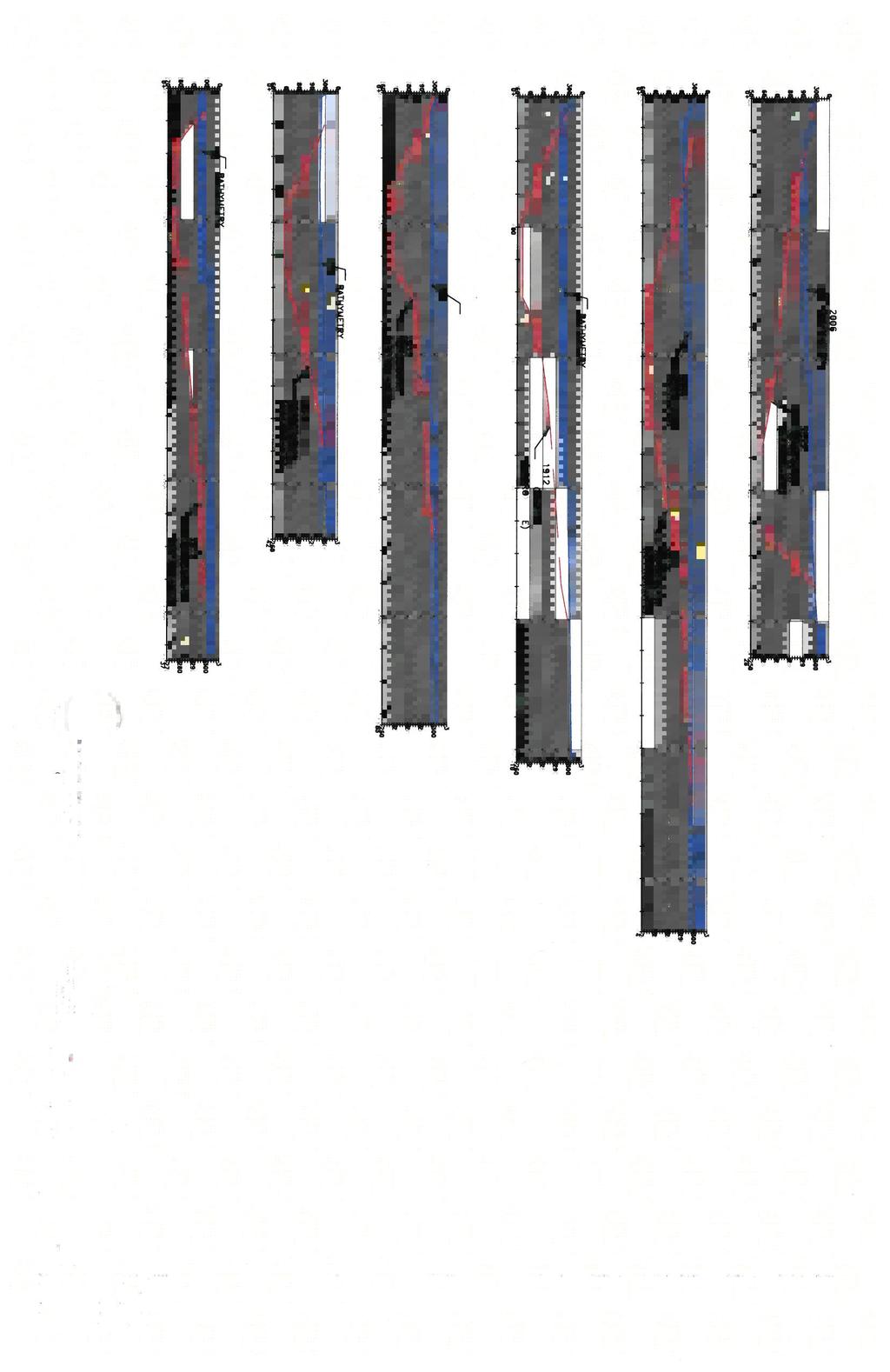
15 2.1.2 Sediment Transport Northwestern Lake was created in 1913 when Condit dam was constructed at river mile 3.3 on the White Salmon River. Northwestern Lake extends 1.8-miles upstream of the dam and has a watershed area of about 386 square miles. At normal pool elevation of 295 feet (PacifiCorp Energy datum), the lake has a surface area of approximately 92 acres. Since the dam was constructed, natural transport of sediment by the White Salmon River and tributaries to Northwestern Lake has been disrupted. Silt, sand, gravel, and cobbles that would previously have been transported to the Columbia River are deposited in the slack water of Northwestern Lake created by Condit dam Sediment Deposition Sediment deposition within the reservoir was characterized by comparing historic topography from 1912 (pre-dam) with bathymetry of the lakebed surveyed in 2006 (post-dam). Figures A1 through A3 (Appendix A) show historic topography prior to construction of the dam. Figures B1 through B3 (Appendix B) show the bathymetry of Northwestern Lake as surveyed in Figure C1 (Appendix C) shows a profile of the reservoir sediments through Northwestern Lake. The profile follows the historic alignment of the White Salmon River prior to construction of the dam. The profile shows elevations of the riverbed in 1912 and the surface of sediment deposits in Sediment depths along the historic channel profile can be estimated as the difference between the elevations of the sediment surface and riverbed. Upstream of station 22+00, the surface of the sediment deposits reaches elevations of 290 feet (PacifiCorp Energy datum) or higher. These sediments are anticipated to be exposed and begin eroding when the lake level is lowered to 285 feet (PacifiCorp Energy datum) prior to excavation of the drain tunnel. Along the profile, sediment depths reach a maximum of approximately 65 feet near station Near station in the upper lake, the sediment depth is approximately 20 feet. The upstream extent of the 2006 bathymetry is near station 96+00, therefore sediment deposition depths were not characterized further upstream. A series of cross-sections through Northwestern Lake are provided on Figures C2 through C6 (Appendix C). Approximate sediment depths can be estimated at each of these cross-sections as the difference between the elevations of the 1912 topography and 2006 bathymetry. Using the 1912 topography, the pre-dam channel gradient was estimated through the reservoir reach. Above station 35+00, the channel gradient was about 0.7%. Below station 35+00, the river enters a bedrock gorge, and the channel gradient roughly doubles to approximately 1.5%. As the channel becomes steeper, the river s ability to transport sediment increases Sediment Volume The volume of sediment present in Northwestern Lake has been estimated by comparing bathymetric data with pre-dam topographic information from Bathymetry data was most recently collected from Northwestern Lake in 2006, and this exercise determined that Page 12 of 30 March 15, 2011
16 approximately 2.3-million cubic yards of sediment had collected in the lake since the reservoir was formed in 1913 (Finley, 2006). A previous bathymetry study conducted in 1997 estimated the volume of accumulated sediment at 2.42 million cubic yards (G&G Associates, 2004) Sediment Size Sediment deposited in the reservoir ranges in size from clay to cobbles as shown on Table 2-3. Most of the sediment is comprised of small particles that can readily erode and be transported downstream by the White Salmon River (G&G Associates, 2004). Table 2-3 Size Distribution of Reservoir Sediment Material Description Minimum Size (millimeters) Maximum Size (millimeters) % of Material Volume (cubic yards) Clay ,257 Silt ,783 Very Fine Sand ,936 Fine Sand ,217 Medium Sand ,805 Coarse Sand ,103 Very Coarse Sand ,695 Very Fine Gravel ,938 Gravel and larger ,805 Total 2,421,539 The method used to collect sediment samples for grain size analysis biased the size distribution toward smaller particles (G&G Associates, 2004). Sediment samples were collected by advancing 2-inch diameter or smaller tubes into the sediment using a drill which prevented collection of larger particles. The presence of larger particles was inferred by the behavior of the drill during sampling. Since 2004, no additional work has been conducted to characterize particle size distributions for sediment deposited in Northwestern Lake. Page 13 of 30 March 15, 2011
17 2.1.6 Sediment Distribution As described in the 2004 Sediment Behavior Analysis Report, sediment particles sizes located from the dam, at Station 0+00 to Station are predominantly (over 95%) smaller than 2 millimeters (i.e., sand, silt, and clay). Above Station 75+00, deposited sediment quickly becomes coarser and is comprised mostly of sand and gravel. A series of graphics included in the 2004 Sediment Behavior Analysis Report characterize the distribution of sediment in the reservoir as follows: From Stations 0+00 to 20+00, sediment is mostly clay and silt From Stations to 60+00, sediment is mostly silt and sand From Stations to 90+00, sediment is mostly sand Upstream of Station 90+00, sediment is mostly sand and gravel Stationing, as mentioned above, is located along the thalweg of the White Salmon River as surveyed in Condit dam is located at Station DAM DECOMMISSIONING The removal of Condit dam will initially involve lowering the lake level and excavating a tunnel through the base of the dam to rapidly drain the reservoir. The drain tunnel will have approximate dimensions of 18-feet wide, 12-feet high, and 90-feet long with an invert elevation of 174 feet. The tunnel is designed to function as follows: When the tunnel is initially opened, pass about 10,000 cubic feet-per-second as required to drain the reservoir in six hours, and While the dam is being removed, pass the average monthly flow of 1,000 to 1,500 cubic feet-per-second with a water depth in the tunnel of less than 4 feet. River erosion will remove between 1.6 million to 2.2-million cubic yards of sediment from the reservoir (G&G Associates, 2004). The lower estimate of 1.6-million cubic yards is based on the assumption that all exposed slopes will lay at an angle of 30 degrees (1.73 horizontal to 1 vertical). The higher estimate of 2.2-million cubic yards assumes that exposed slopes comprised of fine-grained material will lay at an angle of 5.7 degrees (10 horizontal to 1 vertical). 2.3 FUTURE CONDITIONS Following the draining of the reservoir, natural erosion of sediment from the reservoir will occur in response to flows in the White Salmon River and tributaries of Northwestern Lake and local erosion caused by rainfall. Natural erosion processes observed to occur in reservoirs following dam removal include head cutting, embankment failures, lateral channel migration, and changes in channel width (Doyle et al., 2002). Natural erosion processes observed to occur downstream of a decommissioned dam include aggradation, changes in stream width, and formation of multiple channels (Doyle et al., 2002). The geomorphic response to dam removal will be strongly influenced by the amount of sediment stored in the reservoir and the ability of the river system to adjust (Doyle et al., 2003a and 2003b). Page 14 of 30 March 15, 2011
18 Attributes of the project that contribute to the White Salmon River s ability to move sediment and rapidly adjust to the new conditions following dam removal include the following: The preponderance of fine-grained sediment within the reservoir The higher magnitude and duration of flows expected to occur immediately upon dam removal Steep channel gradients within the former thalweg of the river A large number of tributary streams that will discharge across the exposed bed of the reservoir When the drain tunnel is opened through Condit dam, the reservoir will rapidly dewater in about six hours. Fine-grained sediments in the lower reservoir will rapidly erode through head cutting to expose the pre-dam riverbed through the narrow bedrock canyon upstream of the dam. As the river head cuts through the deep, fine-grained sediment deposits it will produce side slopes that are tall, nearly vertical, and saturated with water. If the fine-grained sediments found in the lower reservoir drain slowly, then conditions optimal for producing slope failures may occur. These conditions include positive pore-water pressures in the saturated sediments, loss of confining pressure as lake levels rapidly decline, lack of cohesion, and lack of stabilizing vegetation. Extensive slope and bank failures are anticipated to occur in the lower reservoir as the river rapidly head cuts up the bedrock gorge. Coarse-grained sediments found in the upper reservoir are anticipated to drain more freely when the lake level is lowered to an elevation of 285 feet and then when the drain tunnel is opened to rapidly drain the reservoir. Conditions producing slope and bank failures are also anticipated to occur in the upper reservoir however, they are not anticipated to occur as rapidly as in the lower reservoir. Bank failures in the upper reservoir are anticipated to occur as the river head cuts up through the reservoir and in response to flood events that occur over time. According to the 2004 Sediment Behavior Analysis Report, slopes comprised of fine-grained material will have an angle of repose somewhere in the range from 10:1 (horizontal to vertical) to 1.73:1 (horizontal to vertical). Coarse sediments that freely drain will have an angle of repose similar to the upper range (1.73:1) for fine-grained sediments. Page 15 of 30 March 15, 2011
19 3 POST-RESERVOIR DEWATERING ASSESSMENT This section describes the plan for conducting a post-reservoir-dewatering assessment following the dewatering of Northwestern Lake. The assessment will be implemented to: Map sediment remaining in the reservoir, including tributary mouths Estimate the quantity of sediment remaining within the reservoir Evaluate the stability of remaining slopes and banks in the reservoir and determine corrective actions, if necessary Evaluate fish passage conditions through the former reservoir, as described in the Aquatic Resources Protection Plan This information will be included in a progress report that will be prepared and submitted to FERC for review within 120 days after breaching the dam. This report will document progress achieved toward stabilizing the reservoir bed and removing sediment that may impede fish passage and will present a plan for additional measures that may be necessary to stabilize remaining sediments within the reservoir. 3.1 SEDIMENT MAPPING After the reservoir is drained, sediment mapping will be conducted in order to estimate the amount of sediment remaining in the reservoir and to develop information on slopes that may require stabilization. After the breach, ground survey control will be set and a Light Detection and Ranging (LiDAR) survey will be flown of the reservoir bed extending from Condit dam to approximately 1,400-feet upstream of Northwestern Lake Road. The LiDAR data will be collected with sufficient detail to map the topography of the lake bed with a contour interval of 1 foot and a scale of 1 inch equals 100 feet. One foot contours will depict the slopes of the newly formed channel of the White Salmon River through the reservoir with sufficient detail to examine if the observed slopes exceed criteria for stable banks. The sediment mapping data will also be referenced against the original 1912 topography to determine whether observed slopes represent pre-project conditions and determine whether observed sediment is overlaying natural slopes that may be stable. The width of the river channel and various river segments will also be compared to 1912 topography data to determine if the river has re-established previous natural channel widths and whether significant further lateral erosion of sediments is expected. Additional LiDAR mapping will be conducted as part of ongoing monitoring activities as described in Section 5. JR Merit is the Construction Contractor retained by PacifiCorp Energy to accomplish the Condit Dam Decommissioning project. JR Merit has reviewed the required time constraints to complete each LiDAR survey, and the submittal timeline for the Sediment Assessment Report (Section 3.4). It is JR Merit's intention herein, to clarify the timeline for the first LiDAR survey and gain agreement amongst Agency personnel for the Sediment Assessment Report submittal date to meet all of the Plan objectives. At this time the project guidance documents list the following timeline requirements: Page 16 of 30 March 15, 2011
20 The FERC Surrender Order (December 16, 2010) requires within 90 days of the commencement of reservoir dewatering: (a) the results of the analysis, (b) comments of consulted entities, (c) licensee's response to entities comments, and (d) any measures proposed by the licensee to manage residual sediments and restore the White Salmon River valley in the reservoir area to a stable, free-flowing condition." Conclusions Section (M) (7) page 72. The Washington Department of Ecology's 401 Certification (October 12, 2010) requires a "...post-reservoir-dewatering assessment progress report to Ecology for review within 120 days after breaching the dam." Section Sediment Management and Monitoring, 3) Interim Limit, page 12. Ecology also requires a draft report regarding sediment behavior (see Section 5.2) within 60 days after breaching the dam. JR Merit intends to take a pro-active approach to sediment management in the reservoir area. It is JR Merit's intention to use hydraulic excavation techniques within the first 75 days post breach to mobilize a limited portion of the sediment volume. This sediment mobilization work will focus primarily of the steep slope areas and locations where erosion of the river channel is creating tall, unstable slopes. JR Merit believes that it is in the best interest of the project to accomplish the first LiDAR survey after this initial sediment stabilization work has been completed. In order to meet the submittal deadline of 120 days post breach for the Sediment Assessment Report (Section 3.4), JR Merit will undertake the first LiDAR survey at the 75 day post breach point in time. JR Merit and its subcontractors will need 45 days to complete the LiDAR data acquisition, data processing, map building, sediment stability analysis, sediment volumetric calculations, preparation of the Sediment Assessment Report and preparation of the proposed grading plan for the remaining reservoir sediments. JR Merit will complete a Draft Sediment Behavior Report (Section 5.2) as required by Ecology, and will submit this document to Ecology within 60 days. This report will be based on our weekly field inspections of the reservoir sediment evolution post breach. This Draft Sediment Behavior Report will also be provided to FERC, to meet FERC's requirement for a "filing" within 90 days (post breach). However, the final Sediment Assessment Report will not be completed until or before the 120 day post breach point in time. 3.2 REMAINING SEDIMENT QUANTITY ESTIMATION The data obtained from the LiDAR survey following dam removal will be compared with the 2006 bathymetry data to estimate the quantity of sediment that has been removed from the reservoir and the quantity that remains. This information will be used to assess the progress towards attaining natural sediment conditions within the reservoir and stable slopes and banks. 3.3 SLOPE STABILITY EVALUATION JR Merit intends to make site visits and evaluate the stability of reservoir sediments on a weekly basis during the 75-day post breach time period. The evaluations will be made by a trained geologist or engineer. Brief written reports will be made following each site visit. Page 17 of 30 March 15, 2011
21 Photographs of sediment formations will be taken, including repeat photographs from certain vantage points. The weekly evaluations may be used to guide JR Merit s efforts at hydraulic mobilization of reservoir sediments, and as the basis for the Draft Sediment Behavior Report. It is expected that this regular monitoring of the sediment deposits will yield specific data regarding stable angles of repose, particularly as the characteristics of the sediment deposits change along the length of the reservoir. In the lower reservoir, the river is anticipated to rapidly downcut into the narrow bedrock canyon when the reservoir is drained. Subsequently, river flows including floods will be contained within the bedrock canyon and will no longer access sediment deposits located above the canyon rim. For sediment deposits located above the canyon rim, the stability of slopes may be influenced by local runoff, seeps, and tributaries, but will no longer be influenced by the river. Upstream of the bedrock canyon, in the upper reservoir, floods along the river will continue to access sediment deposits located on the reservoir bed. In the upper reservoir, above the bedrock canyon, the river is anticipated to erode laterally into sediment deposits in response to flood events, thereby strongly influencing the stability of slopes and banks. The water draining through the reservoir is anticipated to entrench a new channel in the approximate area of the former river channel that existed prior to construction of the dam. Previous geotechnical studies and bathymetry surveys indicate the former channel has been backfilled with sediments to depths exceeding approximately 80 feet. These slopes will be exposed once decommissioning is completed and an evaluation of their stability is necessary to support the design and construction of restoration improvements. Due to the rapid drawdown of the reservoir water during dam decommissioning, the newlyentrenched channel banks are anticipated to be unstable and subject to slope failures. Marginal slope stability may exist at the estimated angle of repose values for the various soil types underlying the channel banks once the river has re-established its former channel. The slope stability assessment will consist of site reconnaissance of slopes and banks and observations of the site-specific conditions that may influence local slope stability. Generally, soils and sediments in the reservoir that remain after the river has re-established its former channel and channel width are expected to be stable at an angle of repose of less than 30 degrees (1.73 horizontal to 1 vertical). Steeper slopes will be encountered where rock formations or canyon walls underlie remaining sediments and provide support. The slope stability assessment will identify over-steepened areas (i.e., generally exceeding a 30- degree angle of repose); areas of embankment failure; ground cracking; groundwater springs and seepage; and areas of accelerated erosion. The assessment will determine whether the identified areas need to be addressed based on site conditions, the risk posed by potential slope instability, and the likelihood that natural short-term erosion processes will achieve a stable condition. Corrective actions will be identified to remedy unstable slopes that pose a public safety risk that are not anticipated to be self-correcting as short-term natural erosion proceeds. Page 18 of 30 March 15, 2011
22 3.4 ASSESSMENT REPORT Within 120 days of breaching the dam, a report will be developed and submitted to FERC and the Washington Department of Ecology that includes the information described above and the results of the slope stability assessment. The report will document progress made toward stabilizing slopes and river banks within the reservoir bed and removing sediment and debris that may impede fish passage. Planned actions for managing sediment within the reservoir to attain stable conditions and improve fish passage conditions will be documented Grading Plan for the Reservoir Area JR Merit intends to prepare a grading plan for the reservoir area, which will be submitted for review concurrently with the Sediment Assessment Report. The grading plan will utilize the LiDAR topography obtained at the 75 day time period, showing what sediments remain within the reservoir area and how the topography will be altered to achieve a long-term stable landform. The grading plan will show proposed slopes and contouring to facilitate revegetation of upland areas, stabilization of side drainages, and identification of locations where establishment of new wetlands is likely to occur. Page 19 of 30 March 15, 2011
23 4 SEDIMENT MANAGEMENT MEASURES Sediment impounded behind Condit dam will be removed primarily through natural erosion processes as the reservoir is drained and as the river reestablishes its former channel over time. Sediment will be actively managed where necessary to assure public safety and to develop stable conditions as expeditiously as possible. Stable conditions are necessary to provide fish passage through the project area and allow revegetation of the reservoir to proceed. This section describes the natural sediment removal processes that will be primarily relied upon to manage sediment within the former reservoir area of Northwestern Lake as well as the active and passive sediment management measures that may be employed during the decommissioning process. 4.1 NATURAL SEDIMENT REMOVAL PROCESSES Natural sediment erosion processes will be relied upon to perform the majority of work necessary to remove impounded sediment from the former reservoir and restore the reservoir area to natural, stable contours that existed prior to construction of Condit dam. Natural sediment erosion processes that will mobilize a large proportion of reservoir sediments in a short amount of time following reservoir dewatering and that will establish slope stability are the processes that will be relied upon before active sediment management measures are undertaken. These large-scale, natural erosion processes within the reservoir will include river and tributary channel formation through knick point migration and mass wasting of side slopes. Because surficial erosion processes can result in large sediment loss over longer time scales, these erosion processes will not be encouraged. Additionally, these processes cannot be relied upon to erode sediment slopes in the short time frame in which it is desirable to assure that public safety risks are reduced Head Cutting and Knick Point Migration Channel formation through head cutting and knick point migration involves river flows pouring over a near-vertical face of sediment. As the water pours over the knick point, turbulence erodes, or head cuts, the face of sediment and flows carry the eroded sediment downstream. The eroding face of sediment is called the knick point. The knick point migrates upstream as flows carry the eroded sediment downstream. This process is easily identified by the presence of a cascade feature in the river and sediment laden flows downstream of the cascade. After the drain tunnel is blasted open, it is anticipated that a series of knick points will migrate upstream in a fairly rapid manner. If knick point migration becomes arrested, it is likely that courser sediment, a log jam, or other debris has been encountered; or that the sediment carrying capacity of downstream flows has been exceeded. In most cases, time and/or increased river flow will restore the knick point migration after it is arrested. Knick point migration advances upstream parallel to the direction of river flow Mass Wasting As knick points migrate upstream, a second natural process called mass wasting will be initiated as riverbanks and side slopes become undermined. Mass wasting refers to landslides and is a process that generally works perpendicular to river flow. Many Page 20 of 30 March 15, 2011
24 undermined riverbanks and side slopes will become landslides because a migrating knick point has removed sediment supporting them at the toe of slope. Landslides characterize the mass wasting process that is dynamically coupled with knick point migration. Knick point migration removes the supporting toe of a slope causing side slopes to fail and slide into the river channel. When mass wasting occurs, large volumes of sediment slide into the river channel - usually overwhelming the river s sediment carrying capacity and potentially arresting the upstream knick point migration that initiated the landslide. Typically, another knick point will be initiated at the downstream edge of the sediment that slid into the river channel. Mass wasting of side slopes creates a series of knick points whose migration will ultimately depend upon the river s sediment carrying capacity. Time and high river flow events will create dramatic changes to the reservoir landscape through the knick point migration and mass wasting processes. However, some slopes may not achieve a stable condition as a result of these processes and may be on the verge of failure. Slopes that do not slide but are on the verge of failure are extremely unsafe since the weight of a person walking on the slope could result in slope failure. The likelihood of unstable slopes being present following initial natural sediment movement processes and the desire to quickly reduce public safety risks following reservoir dewatering creates the need for active stabilization measures. 4.2 ACTIVE SEDIMENT MANAGEMENT AREAS Active sediment management measures will be employed to actively collapse unstable reservoir sediments into the White Salmon River to attain safe and stable slopes and river banks and promote long-term sediment stabilization expected to be achieved through natural and targeted revegetation. Active sediment management measures will supplement natural sediment removal processes and be implemented to speed up the process for sediment removal from the reservoir which is expected to reduce the duration of suspended sediment in the river. Areas requiring active sediment management and stabilization will be identified as part of the slope stability evaluation described in Section 3.3 as well as during ongoing site evaluation and reconnaissance conducted throughout the duration of project decommissioning activities. The areas where active sediment measures will be employed are described more fully below Slope Stabilization As the river erodes sediment from the former river channel, active stabilization measures will be employed to establish stable slopes in the canyon for the protection of public safety and to hasten the development of stable conditions that will allow for targeted revegetation efforts to proceed. Slope stabilization measures will be conducted with the understanding that bedrock will have a profound influence on the geometry of finished slopes and that the exact locations and heights of bedrock are unknown. Historic photographs of the White Salmon River prior to the construction of Condit dam and the original 1912 topography data indicate that a bedrock canyon with near vertical canyon walls exists within the reservoir. Thus, the location of bedrock will dictate where the toe of Page 21 of 30 March 15, 2011
25 slope of overlying sediment begins. Stable slope angles of overlying sediments will be projected up from underlying bedrock when assessing slope stability. Where possible, information from the 1912 topographic maps and the sediment mapping exercise described in Section 3.1 will be used to evaluate whether particular slopes require stabilization. As described in Section 3, slopes that are steeper than 30 degrees (1.73 horizontal to 1 vertical) will generally be assessed to determine whether they are stable or whether additional active stabilization measures are necessary Bank Stabilization Bank stabilization refers to side slopes immediately adjacent to the newly reestablished river. In addition to stabilizing slopes that may form far away from the river, active stabilization may be necessary to reduce the slope of near-vertical, potentially unstable riverbanks. These riverbanks may pose a public safety risk that could persist after public access to the reservoir area is no longer controlled. After natural processes and high flow events have enlarged the width of the river, steep riverbanks may remain. Where these riverbanks are determined to be unstable or pose a public safety risk, they will be collapsed to attain a stable angle of repose at an expected slope of 30 degrees (1.73 horizontal to 1 vertical). The stabilization of the riverbanks will encourage the growth of native riparian vegetation that may provide longterm stability. Planting strategies for the riverbank are discussed in the Revegetation and Wetlands Management Plan Revegetation Preparation In addition to attaining slope and bank stability, active sediment management measures may be employed to provide suitable soil substrates that will promote the establishment of vegetation that will promote long-term stability of the newly exposed reservoir slopes. It is likely that different reservoir sediment types will appear in lenses, such as cobble, gravel, sand, and silt. The different sediment types anticipated to be encountered as lenses or layers within the reservoir will be considered for their suitability as a growing medium for vegetation in areas that are targeted for revegetation efforts. Courser sediments such as cobble and gravel are an undesirable growing medium for vegetation but are desirable as streambed substrate. Thus, it is generally preferred to release gravel and cobble lenses to the river and retain finer-grained sediments such as sand and silt in areas where long-term stability and erosion control may be achieved through suitable revegetation measures. Where heavy equipment access is possible, cobble and gravel sediments overlaying finer grained soils that are more suitable for revegetation may be pushed into the river. Fine grained sediments may also be stockpiled and spread over exposed areas of cobble or gravel located above the new ordinary high water elevation to provide more suitable vegetative substrate and increase the moisture retention characteristics of the soil. JR Merit believes that active sediment management measures may be necessary to obtain a stable landform of the remaining reservoir sediments within a reasonable time frame, and to minimize the safety hazards posed by tall, unstable sediment banks. The preferred method of active sediment management is dependent on the location of the sediment and the grain size of that sediment. Figure D7 "Preliminary Plan for Sediment Management" shows the Page 22 of 30 March 15, 2011
26 approximate locations of different sediment types. Once the reservoir has been drained, JR Merit will be able to monitor the behavior of the sediments, and will be able to better determine the appropriate methods of active sediment management in a particular area. 4.3 ACTIVE SEDIMENT MANAGEMENT MEASURES Sediments may be actively managed through a variety of methods to provide sediment stability and promote the eventual revegetation of the reservoir through natural processes and targeted revegetation efforts. Methods to collapse unstable sediments that will likely be feasible and expedient to employ in the reservoir area are described below. Other solutions may be developed in the field in response to specific site conditions and as a result of creative use of the available heavy equipment Heavy Equipment Sediment and debris removal, stockpiling, and grading using heavy equipment may be performed where access and soil stability allow. Heavy equipment may include excavators, bulldozers, graders, yarders or other equipment. The saturated and unstable nature of reservoir sediments immediately following reservoir dewatering will limit the use of heavy equipment. In addition, the difficulty in accessing the reservoir in some locations will limit heavy equipment use. The inside of river bends are typically more mildly sloped than the outside of river bends due to natural channel morphology. As such, heavy equipment access to the reservoir may be more easily developed at the inside of bends in the river. Areas where heavy equipment access will likely be possible after the reservoir is dewatered are shown in Figures D1 through D6 (Appendix D). Where access allows, unstable sediments may initially be pushed into the river using heavy equipment such as a long reach excavator. Equipment such as this that can reach long distances, up to 40 feet, without surcharging unstable soils may possibly be operated safely immediately following reservoir dewatering. Based upon site conditions and access limitations, other heavy equipment may be used to push sediment into the river in order to achieve stable slopes Hydraulic Excavation Where access is limited, hydraulic excavation may be performed to erode sediments into the river and collapse unstable slopes. Hydraulic excavation consists of shooting a high pressure jet of water at the base of unstable sediments to erode the toe of the slope and promote its collapse. Hydraulic excavation will require the use of small, portable temporary dams or barriers in the White Salmon River to impound water for the hydraulic excavation pumping system. The temporary, portable dam may simply consist of a highway barrier placed in the river to provide backwater for the pump intakes. Hydraulic excavation may be performed from the stable shoreline of the current reservoir or with equipment working from within, or near the shoreline of, the newly reestablished river. Outside bends of the newly reestablished river will generally be inaccessible to heavy equipment due to steep side slopes. Thus, hydraulic excavation may be a preferred method for promoting slope stabilization in these areas. Where steep bedrock is encountered, as expected at the outside river bends, care will be exercised to avoid scouring all soil off of Page 23 of 30 March 15, 2011
27 bedrock surfaces since a small amount of soil in these areas may provide an essential growing medium Blasting Blasting is another method that may be used to collapse unstable slopes within the former reservoir area or to remove or dislodge debris from the reservoir. If identified as a feasible alternative to address site conditions observed following the draining of the reservoir, blasting may be employed under strict controls. A blasting plan will be prepared that will document the exact location and timing of blasting activities and the necessary safety measures to be employed during execution of the blasting plan. The blasting plan will be submitted to FERC for review and approval prior to initiating blasting activities Site Access Temporary access roads will be constructed by the Contractor from existing access points and across the river bed, as necessary, to mobilize equipment for sediment removal. Existing access points are shown in Figure D1 (Appendix D). Temporary access roads will be reclaimed when they are no longer necessary as described in the Erosion Control Plan. However, the use of these access roads will be necessary for vegetation establishment, maintenance, and weed control after sediment stabilization measures have been completed Anticipated Measures for Active Sediment Management Figure D7 (Appendix D) "Preliminary Plan for Sediment Management" shows the most probable methods that JR Merit will use to actively manage reservoir sediments. JR Merit is considering the use of hydraulic excavation techniques during the first 75 days after the breach event. This methodology is considered the most flexible method of mobilizing sediment into the river, when a considerable amount of water is still contained within the pore spaces of the sediment deposits. Immediately after the breach event, heavy equipment will not be able to operate in the reservoir area. This limitation may persist for weeks or months, depending on the type of sediment, precipitation events, and other factors. Beginning in the spring following the breach event, JR Merit anticipates that heavy equipment will be able to shape final grading contours, particularly in the upper sections of the reservoir. If JR Merit can safely access the White Salmon River in the reservoir area within the first 75 days, then their plan for hydraulic excavation would be as follows: 1. Create a temporary shallow pool in the active river channel by temporarily placing large boulders or precast concrete vehicle barriers. 2. Locate portable water pumps near the river, for a suction intake system from the temporary shallow pool. All suction intakes would have approved fish screens. Total pump capacity would be approximately 500-1,000 gallons per minute. 3. Utilize standard fire hose equipment to convey the pressurized water to an upland location, downstream of the water pumping equipment. 4. Utilize standard fire-fighting nozzles and custom fabricated support stands to direct the pressurized water flow onto sediment deposits that are potentially unstable or those deposits that cannot be reached with conventional earthmoving equipment. Page 24 of 30 March 15, 2011
28 Maintain on-site operators to keep the equipment functioning as intended, and to prevent damage to areas where no sediment management is needed. JR Merit and PacifiCorp Energy recognize that mobilizing some sediment into the White Salmon River during the first 75 days post breach is beneficial to the project as a whole. From a safety perspective it is preferable to prevent tall, unstable sediment banks from becoming exposed and the ensuing mass wasting events from occurring. Mobilizing some of the reservoir sediments when the river is already moving large quantities of sediment, when impacts to aquatic resources are expected, and when the river has its highest annual flow regimes makes practical sense. After the initial 75 days of sediment erosion and mobilization, most of the remaining reservoir sediments should have adequate slope stability. The shape of the remaining sediments will probably not be immediately conducive to revegetation. JR Merit anticipates that areas of wide sediment deposition on moderate slopes and some side drainages will require final grading to achieve a suitable long-term form. The grading plan will consider elements such as contour berms, streambed stabilization in side drainages, shaping of riverbanks and adjacent floodplains, and shaping of suitable areas for wetlands development. Final grading and drainage improvement work will require the use of heavy equipment, and this can best be achieved with relatively dry conditions. Such conditions are not expected until April of each year, and typically last until October. 4.4 PASSIVE STABILIZATION MEASURES Passive stabilization measures include natural revegetation, vegetative treatments, seeding, and planting. Passive stabilization measures will resist surficial erosion resulting from heavy rains and promote long-term stability of slopes and riverbanks. Following natural sediment removal processes, it will be determined where passive erosion control measures such as seeding, mulching, and planting may be appropriate. The applicability of passive measures will primarily depend upon the attainment of slope stability criteria and the presence of suitable soil conditions. Revegetation measures and the criteria that will be used to assess revegetation measures are described in detail in the Revegetation and Wetlands Management Plan. Page 25 of 30 March 15, 2011
29 5 MONITORING This section outlines monitoring that will be implemented after the reservoir is drained to assess the progress of the former reservoir towards a safe and stable natural condition and to direct ongoing stabilization activities to progress towards that goal. The monitoring plan contains the following elements: routine field inspections to identify unstable embankments and provide active management recommendations to ensure public safety and achieve stable conditions within the former reservoir reach; and a study that will compare sediment transport and geomorphic response observed following reservoir draining to the assumptions and modeling described in the Sediment Behavior Analysis Report (G&G Associates, 2004). 5.1 ROUTINE FIELD INSPECTIONS After the reservoir is drained, routine field inspections will be conducted of the reservoir area and of the downstream portion of the White Salmon River. The purpose of these inspections will be to identify unstable slopes, debris jams, fish passage problems, and develop strategies to address the observed conditions. The inspections will also note the progress of sediment erosion through the former reservoir area and note, if possible, the location of the main river channel knick point as it migrates upstream. The inspections will also serve to document the progress of the reservoir area and lower river towards stable, natural conditions. Field inspections are anticipated to occur as frequently as necessary to respond to the dynamic changes expected following reservoir dewatering. Inspections will become less frequent as stability within the reservoir area increases but will occur after significant high flow or rainfall events that may mobilize significant amounts of sediment or cause slope instability or failure. 5.2 VIDEO AND PHOTO MONITORING Video monitoring will be conducted following breaching to document and characterize immediate geomorphic response of the reservoir bed to breaching of the dam. Similar video monitoring was conducted during removal of the Marmot dam on the Sandy River in the fall of JR Merit will collect continuous video images of the breach event from three vantage points: looking upstream from the dam, looking at the river immediately below the dam, and looking at the river from the Powerhouse. This video footage will record the pre-breach conditions, the breach event, and the ensuing 6 hours (+/-) until the flow through the tunnel drops down to the approximate rate of water entering the reservoir area. Video coverage of the reservoir immediately above the dam will continue past the 6-hour time point if visible changes to the reservoir sediment form are continuing. In addition to the video images, JR Merit will collect still photo images from multiple locations around the reservoir, primarily from accessible vantage points such as Lake Road, Northwestern Lake Bridge, Graves Road, and the dam itself. These photo points will be repeated daily for the first seven days post-breach, and weekly thereafter for the first 75 days post breach. JR Merit will document sediment deposition between the dam and the Underwood In Lieu Site during the first seven days post breach, and then monthly during the first 75 days. This sediment deposition documentation will be limited to locations that can safety be accessed in the canyon reach and below the powerhouse. Page 26 of 30 March 15, 2011
30 A report will be prepared that compares observed sediment transport dynamics and geomorphic response to assumptions and modeling results presented in the 2004 Sediment Behavior Analysis. 5.3 LIDAR SURVEYS AND SEDIMENT VOLUME CALCULATIONS A series of LiDAR surveys will document and characterize geomorphic response of the White Salmon River and accumulated reservoir sediments over the time frame of two to three years. LiDAR surveys will provide detailed topography of the reservoir bed that will allow quantitative estimation of the volume of sediment removed from the reservoir through natural erosion processes and active removal to stabilize slopes. As previously described in Section 3.1, after dewatering the reservoir, ground survey control will be set and an initial LiDAR survey will be flown of the reservoir bed that extends from Condit dam to approximately 1,400-feet upstream of Northwestern Lake Road. At the end of the first rainy season following dam breaching, a second LiDAR survey will be flown and mapped as described above. The topography will be reviewed, compared to the previous survey, and evaluated. The topographic surfaces will be compared through surface subtraction to estimate volumes of cut and fill within the reservoir bed. A third LiDAR survey will be conducted at the end of the second rainy season after breaching as described above. Analysis of the topography and aerial photographs will be performed as described above. Cut and fill volumes will be estimated as previously described. Based on the results of this third LiDAR survey, a determination will be made about the need for additional future surveys. If the river channel and floodplain have achieved a state of stability and the volume of sediment discharged from the system has leveled off, then monitoring and analysis using LiDAR will be discontinued. The results of the LiDAR surveys will be communicated to FERC and the Washington Department of Ecology in annual progress and monitoring reports. The LiDAR surveys will also be used to compare the predicted geomorphic response and sediment volume discharge estimates presented in the 2004 Sediment Behavior Analysis Report with what is observed in the field. 5.4 AERIAL PHOTOGRAPHY After the reservoir is drained, aerial photographs of the reservoir bed and downstream reaches of the river will be taken. The upstream extent of the aerial photographs will be 1,400-feet upstream of Northwestern Lake Road Bridge. The downstream extent of the aerial photographs will be 500-feet downstream of SR14. Aerial photography will be collected one and two years after the reservoir is drained. The aerial photographs will be high resolution photographs (i.e., 1 meter resolution or better). They will supplement the routine field inspections described in Section 5.1 and be used to document the progress of sediment stabilization efforts and revegetation measures. Page 27 of 30 March 15, 2011
31 5.5 CRITERIA FOR CESSATION OF ACTIVE MANAGEMENT AND MONITORING The data collected as part of the monitoring program will be used to determine when the reservoir has attained a stable condition. A stable condition will generally be attained when: Remaining slopes and banks are stable and do not present a public safety risk The river within the former reservoir area has attained a stable course and channel width. The amount of sediment released from the reservoir is not longer significant, as determined from water quality (turbidity) measurements and from LiDAR sediment mapping and sediment quantity calculations. Upon attainment of these criteria, the reservoir will have attained or be on a trajectory to attain natural conditions, and PacifiCorp Energy will cease monitoring of the project area for the purposes of sediment management. However, monitoring required as part of other management plans will continue based upon the criteria for those specific monitoring efforts. Page 28 of 30 March 15, 2011
32 SEDIMENT ASSESSMENT, STABILZATION, AND MANAGEMENT PLAN CONDIT HYDROELECTRIC PROJECT DECOMMISSIONING (FERC PROJECT NO. 2342) 6 REFERENCES Condit Hydroelectric Project Settlement Agreement, September Condit Hydroelectric Project (FERC Project No. 2342), Project Description. Updated June Condit Hydroelectric Project Settlement Agreement Amendment, February. Doyle, M. W., Stanley, E. H., and Harbor, J. M., Geomorphic Analogies for Assessing Probable Channel Response to Dam Removal, Journal of the American Water Resources Association, Vol. 38, pp Doyle, M.W., Harbor, J.M., 2003a. A Scaling Approximation of Equilibrium Time-scales for Sand-bed and Gravel-bed Rivers Responding to Base-level Lowering. Geomorphology 54, Doyle, M.W., Stanley, E.H, Selle, A.R., Stofleth, J.M., and Harbor J.M., 2003b. Predicting the Depths of Erosion in Reservoirs Following Dam Removal using Bank Stability Analysis, International Journal of Sediment Research, Vol. 18, pp Federal Energy Regulatory Commission (FERC), Final Environmental Impact Statement - Condit Hydroelectric Project Skamania and Klickatat Counties, Washington (FERC Project No. 2342). Federal Energy Regulatory Commission, Final Supplemental Final Environmental Impact Statement - Condit Hydroelectric Project, Washington (FERC Project No. 2342). Finley Engineering Company, Condit Dam and Northwestern Lake Hydrographic Surveys Final Report, August. GEC, Drain Tunnel Blocking Investigation, October. G&G Associates, Condit Hydroelectric Project Removal Sediment Behavior Analysis Report, May. JR Merit and Riverbend Engineering, Sediment Assessment, Stabilization, and Management Plan Addendum, Prepared for PacifiCorp Energy. FERC Project No National Marine Fisheries Service (NMFS), Biological Opinion and Magnuson- Stevens Fishery Conservation and Management Act Consultation, NMFS Northwest Region, Hydropower Division, NMFS Log Number 2002/00977, October 12. PacifiCorp Energy, Spill Prevention, Control, and Countermeasures Plan. Prepared by Kleinfelder, FERC Project No Page 29 of 30 March 15, 2011
33 PacifiCorp Energy, Condit Hydroelectric Project Technical Specifications, Prepared by Mead & Hunt and Kleinfelder, FERC Project No PacifiCorp Energy, 2011a. Condit Hydroelectric Project Aquatic Resources Protection Plan, prepared by Inter-Fluve, HDR, Kleinfelder, and JR Merit, FERC Project No PacifiCorp Energy, 2011b. Project Removal Design Report. Prepared by Mead & Hunt, Kleinfelder, and JR Merit, FERC Project No PacifiCorp Energy, 2011c. Woody Debris Management Plan. Prepared by Inter-Fluve, Kleinfelder, and JR Merit, FERC Project No R.W. Beck, Condit Hydroelectric Project Removal, Summary Report Engineering Considerations, May. United Nations Conference on Trade and Development (UNCAD), Convention on Biological Diversity (CBD), BioTrade Initiative, U.S. Fish and Wildlife Service (USFWS), Reinitiation of Consultation on Bull Trout (Salvelinus confluentus) and Consultation on Bull Trout Critical Habitat for Condit Dam Removal and Dam Operation, FWS Reference F-0059, Lacey, Washington. Washington State Department of Ecology (Ecology), Condit Dam Removal Final SEPA Supplemental Environmental Impact Statement, Ecology Publication # Page 30 of 30 March 15, 2011


34


35


36


37


38
39


40
41


42
43


44

45

46


47


48


49


50

51


52
WOODY DEBRIS MANAGEMENT PLAN
 Condit Hydroelectric Project Decommissioning FERC Project No. 2342 WOODY DEBRIS MANAGEMENT PLAN Prepared by. Prepared for MARCH 15, 2011 TABLE OF CONTENTS 1 INTRODUCTION... 1 1.1 PROJECT DESCRIPTION...
PRELIMINARY SEDIMENT BEHAVIOR REPORT
 Condit Hydroelectric Project Decommissioning FERC Project No. 2342 PRELIMINARY SEDIMENT BEHAVIOR REPORT Prepared by: And Prepared for: December 18, 2011 Preliminary Sediment Behavior Report Table of Contents
POST-RESERVOIR-DEWATERING ASSESSMENT REPORT
 Condit Hydroelectric Project Decommissioning FERC Project No. 2342 POST-RESERVOIR-DEWATERING ASSESSMENT REPORT Prepared by: And Prepared for: February 22, 2012 1.0 Introduction Post-Reservoir-Dewatering
Evaluation of Geomorphic Effects of Removal of Marmot and Little Sandy Dams and Potential Impacts on Anadromous Salmonids
 PRELIMINARY FINAL Evaluation of Geomorphic Effects of Removal of Marmot and Little Sandy Dams and Potential Impacts on Anadromous Salmonids Prepared for: Portland General Electric 121 SW Salmon Street
Project (Project No. US-CA-62-2) Maintenance Inspection and Reports (Subtask 14.1) Inspection Report No.2
 Maintenance Inspection and Reports (Subtask 14.1) Inspection Report No.2") MEMORANDUM TO: FROM: Jim Well, Ducks Unlimited Mike Harvey, PhD, PG SUBJECT: M&T/ Llano Seco Fish Screen Project (Project No. US-CA-62-2) Maintenance Inspection and Reports (Subtask 14.1) Inspection Report
MEMORANDUM TO: FROM: Jim Well, Ducks Unlimited Mike Harvey, PhD, PG SUBJECT: M&T/ Llano Seco Fish Screen Project (Project No. US-CA-62-2) Maintenance Inspection and Reports (Subtask 14.1) Inspection Report
3.12 Geology and Topography Affected Environment
 3 Affected Environment and Environmental Consequences 3.12 Geology and Topography 3.12.1 Affected Environment 3.12.1.1 Earthquakes Sterling Highway MP 45 60 Project Draft SEIS The Kenai Peninsula is predisposed
CHAPTER GEOLOGICALLY HAZARDOUS AREAS Applicability Regulations.
 CHAPTER 19.07 GEOLOGICALLY HAZARDOUS AREAS 19.07.010 Applicability. Geologically hazardous areas may pose a threat to the health and safety of citizens when incompatible development is sited in areas of
Strategies for managing sediment in dams. Iwona Conlan Consultant to IKMP, MRCS
 Strategies for managing sediment in dams Iwona Conlan Consultant to IKMP, MRCS 1 Sediment trapping by dams Active storage capacity Dead storage coarse material (bed load) Fine materials (suspension) Francis
RESERVOIR DRAWDOWN RATES/RESERVOIR DRAWDOWN TEST Iron Gate, Copco (I & II), and JC Boyle Dams
, and JC Boyle Dams") TECHNICAL MEMORANDUM No. 1 TO: Michael Bowen California Coastal Conservancy Geotechnical & Earthquake Engineering Consultants CC: Eric Ginney Philip Williams & Associates PREPARED BY: Paul Grant SUBJECT:
TECHNICAL MEMORANDUM No. 1 TO: Michael Bowen California Coastal Conservancy Geotechnical & Earthquake Engineering Consultants CC: Eric Ginney Philip Williams & Associates PREPARED BY: Paul Grant SUBJECT:
Subcommittee on Sedimentation Draft Sediment Analysis Guidelines for Dam Removal
 Subcommittee on Sedimentation Draft Sediment Analysis Guidelines for Dam Removal August 4, 2011 Jennifer Bountry, M.S., P.E. Tim Randle, M.S., P.E., D.WRE. Blair Greimann, Ph.D., P.E. Sedimentation and
Case Study 2: Twenty-mile Creek Rock Fords
 Case Study : Twenty-mile Creek Rock Fords Location Crossing Description Washington. Okanagan National Forest. Methow Valley Ranger District. Chewuch river basin, East Chewuch Road. The Twenty-mile Creek
Why Geomorphology for Fish Passage
 Channel Morphology - Stream Crossing Interactions An Overview Michael Love Michael Love & Associates mlove@h2odesigns.com (707) 476-8938 Why Geomorphology for Fish Passage 1. Understand the Scale of the
Final Report. Prepared for. American Rivers, California Trout, Friends of the River and Trout Unlimited
 A of the Potential Downstream Sediment Deposition Following the Removal of Iron Gate, Copco, and J.C. Boyle Dams, Klamath River, CA Final Report Prepared for American Rivers, California Trout, Friends
Solutions to Flooding on Pescadero Creek Road
 Hydrology Hydraulics Geomorphology Design Field Services Photo courtesy Half Moon Bay Review Solutions to Flooding on Pescadero Creek Road Prepared for: San Mateo County Resource Conservation District
Appendix K.2: Sediment Management Excerpt from South Orange County Hydromodification Management Plan
 Appendix K.2: Sediment Management Excerpt from South Orange County Hydromodification Management Plan 4 Sediment Supply Management Requirements Permit Order R9-2013-0001 as amended by Order No. R9-2015-0001Section
Lower South Fork McKenzie River Floodplain Enhancement Project
 Lower South Fork McKenzie River Floodplain Enhancement Project McKenzie River Ranger District Willamette National Forest Project Location The project is located in the South Fork McKenzie River Watershed,
EAGLES NEST AND PIASA ISLANDS
 EAGLES NEST AND PIASA ISLANDS HABITAT REHABILITATION AND ENHANCEMENT PROJECT MADISON AND JERSEY COUNTIES, ILLINOIS ENVIRONMENTAL MANAGEMENT PROGRAM ST. LOUIS DISTRICT FACT SHEET I. LOCATION The proposed
Stream Simulation: A Simple Example
 Stream Simulation: A Simple Example North Thompson Creek, CO Paul T. Anderson U.S.D.A. Forest Service Here s How We Started May 2011 2-1 USDA-Forest Service Here s How We Finished Forest Service Aquatic
Materials. Use materials meeting the following.
 208.01 Section 208. SOIL EROSION AND SEDIMENTATION CONTROL 208.01 Description. Install and maintain erosion and sedimentation controls to minimize soil erosion and to control sedimentation from affecting
1 INTRODUCTION AND MAJOR FINDINGS... 1
 Memorandum To: Lindsey Clark, Stillwater Valley Watershed Council Coordinator From: Chad Raisland, Pioneer Technical Services, Inc. and Karin Boyd, Applied Geomorphology, Inc. CC: Tanya Lester, Stillwater
The last three sections of the main body of this report consist of:
 Threatened and Endangered Species Geological Hazards Floodplains Cultural Resources Hazardous Materials A Cost Analysis section that provides comparative conceptual-level costs follows the Environmental
Tarbela Dam in Pakistan. Case study of reservoir sedimentation
 Tarbela Dam in Pakistan. HR Wallingford, Wallingford, UK Published in the proceedings of River Flow 2012, 5-7 September 2012 Abstract Reservoir sedimentation is a main concern in the Tarbela reservoir
[1] Performance of the sediment trap depends on the type of outlet structure and the settling pond surface area.
![[1] Performance of the sediment trap depends on the type of outlet structure and the settling pond surface area.](/thumbs/76/74245181.jpg "[1] Performance of the sediment trap depends on the type of outlet structure and the settling pond surface area.") Sediment Trench SEDIMENT CONTROL TECHNIQUE Type 1 System Sheet Flow Sandy Soils Type 2 System [1] Concentrated Flow Clayey Soils Type 3 System [1] Supplementary Trap Dispersive Soils [1] Performance of
Sediment Trench SEDIMENT CONTROL TECHNIQUE Type 1 System Sheet Flow Sandy Soils Type 2 System [1] Concentrated Flow Clayey Soils Type 3 System [1] Supplementary Trap Dispersive Soils [1] Performance of
Carmel River Bank Stabilization at Rancho San Carlos Road Project Description and Work Plan March 2018
 Carmel River Bank Stabilization at Rancho San Carlos Road Project Description and Work Plan March 2018 EXISTING CONDITION The proposed Carmel River Bank Stabilization at Rancho San Carlos Road Project
3. MARINE HABITAT RESTORATION
 Feasibility Study for Restoration of Titlow Lagoon Fish Passage South Puget Sound Salmon Enhancement Group 3. MARINE HABITAT RESTORATION Marine habitat restoration at Titlow Park could include restoration
Degradation Concerns related to Bridge Structures in Alberta
 Degradation Concerns related to Bridge Structures in Alberta Introduction There has been recent discussion regarding the identification and assessment of stream degradation in terms of how it relates to
Summary of Hydraulic and Sediment-transport. Analysis of Residual Sediment: Alternatives for the San Clemente Dam Removal/Retrofit Project,
 Appendix N SUMMARY OF HYDRAULIC AND SEDIMENT-TRANSPORT ANALYSIS OF RESIDUAL SEDIMENT: ALTERNATIVES FOR THE SAN CLEMENTE DAM REMOVAL/RETROFIT PROJECT, CALIFORNIA the San Clemente Dam Removal/Retrofit Project,
PolyMet NorthMet Project
 RS 26 Draft-01 December 8, 2005 RS26 Partridge River Level 1 Rosgen Geomorphic Survey Rosgen Classification Partridge River from Headwaters to Colby Lake Prepared for PolyMet NorthMet Project December
Elwha River response to dam removals through four years and a big flood:
 Elwha River response to dam removals through four years and a big flood: Lessons learned, channel response, and sediment effects from the world s largest engineered dam removal Andy Ritchie NPS Elwha Restoration
NORTHUMBERLAND COUNTY, PA
 QUAKER RUN Stream and Wetland Restoration As-Built Completion Report and First Year Monitoring Data Coal Township NORTHUMBERLAND COUNTY, PA Upstream Before Upstream After Prepared for: COAL TOWNSHIP 805
PENNSYLVANIA DEPARTMENT OF TRANSPORTATION ENGINEERING DISTRICT 3-0
 PENNSYLVANIA DEPARTMENT OF TRANSPORTATION ENGINEERING DISTRICT 3-0 LYCOMING COUNTY S.R.15, SECTION C41 FINAL HYDROLOGIC AND HYDRAULIC REPORT STEAM VALLEY RUN STREAM RELOCATION DATE: June, 2006 REVISED:
Chapter 3 Erosion in the Las Vegas Wash
 Chapter 3 Erosion in the Las Vegas Wash Introduction As described in Chapter 1, the Las Vegas Wash (Wash) has experienced considerable change as a result of development of the Las Vegas Valley (Valley).
CASE STUDY NATHPA JHAKRI, INDIA
 SEDIMENT MANAGEMENT CASE STUDY NATHPA JHAKRI, INDIA Key project features Name: Nathpa Jhakri Country: India Category: reduce sediment production (watershed management); upstream sediment trapping; bypass
FOR PROJECTS INITIATED AFTER NOVEMBER 1, 2008 ITEM 716 EMBANKMENT EARTH OUTLET SEDIMENT TRAP
 AFTER NOVEMBER 1, 2008 ITEM 716 EMBANKMENT EARTH OUTLET SEDIMENT TRAP 716.1 Description. This work shall consist of furnishing, installing, maintaining, and removing temporary erosion protection and sediment
B-1. Attachment B-1. Evaluation of AdH Model Simplifications in Conowingo Reservoir Sediment Transport Modeling
 Attachment B-1 Evaluation of AdH Model Simplifications in Conowingo Reservoir Sediment Transport Modeling 1 October 2012 Lower Susquehanna River Watershed Assessment Evaluation of AdH Model Simplifications
60 PERCENT DESIGN REPORT HABITAT RESTORATION OF THE CHELAN RIVER REACH 4 AND TAILRACE
 60 PERCENT DESIGN REPORT HABITAT RESTORATION OF THE CHELAN RIVER REACH 4 AND TAILRACE Prepared for Public Utility District Number 1 of Chelan County 327 North Wenatchee Avenue Wenatchee, Washington 98801
CASE STUDY NATHPA JHAKRI, INDIA
 SEDIMENT MANAGEMENT CASE STUDY NATHPA JHAKRI, INDIA Key project features Name: Nathpa Jhakri Country: India Category: reforestation/revegetation; upstream sediment trapping; bypass channel/tunnel; reservoir
B805 TEMPORARY EROSION AND SEDIMENT CONTROL MEASURES - OPSS 805
 B805 MEASURES - OPSS 805 805.1 GENERAL Construction activities frequently remove protective cover and expose soil to accelerated rates of erosion. Sediments generated thereby can be conveyed via runoff
In-channel coarse sediment trap Best Management Practice
 In-channel coarse sediment trap Best Management Practice By Henry R. Hudson July 2002 Environmental Management Associates Ltd., Christchurch Complexity Environmental Value Cost Low Moderate High Low Moderate
DAM REMOVAL ENGINEERING ISSUES & OPTIONS
 DAM REMOVAL ENGINEERING ISSUES & OPTIONS Presented by: James G. Mac Broom, P.E. Milone & Mac Broom, Inc. October 2011 CLEAR GOALS and OBJECTIVES Fish Passage Habitat Defragmentation Water Quality Dam Failure
Appendix E Guidance for Shallow Flooding Analyses and Mapping
 Appendix E Guidance for Shallow Flooding Analyses and Mapping E.1 Introduction Different types of shallow flooding commonly occur throughout the United States. Types of flows that result in shallow flooding
Fish Passage at Road Crossings
 Fish Passage at Road Crossings 1 Crossing Design Workshop Outline 1:00 to 2:00 Intro, Design Overview, Channel Width 2:00 to 2:15 Break 2:15 to 3:15 No-Slope, Stream Simulation Design 3:15 to 3:30 Break
HISTORY OF CONSTRUCTION FOR EXISTING CCR SURFACE IMPOUNDMENT PLANT GASTON ASH POND 40 CFR (c)(1)(i) (xii)
(1)(i) (xii)") HISTORY OF CONSTRUCTION FOR EXISTING CCR SURFACE IMPOUNDMENT PLANT GASTON ASH POND 40 CFR 257.73(c)(1)(i) (xii) (i) Site Name and Ownership Information: Site Name: E.C. Gaston Steam Plant Site Location:
HISTORY OF CONSTRUCTION FOR EXISTING CCR SURFACE IMPOUNDMENT PLANT GASTON ASH POND 40 CFR 257.73(c)(1)(i) (xii) (i) Site Name and Ownership Information: Site Name: E.C. Gaston Steam Plant Site Location:
CCR Rule Annual Inspection Report (cont.) 2
 2") The inspection findings consisted of maintenance items and items that were not observed to be signs or potential signs of significant structural weakness. No deficiencies or disrupting conditions that
The inspection findings consisted of maintenance items and items that were not observed to be signs or potential signs of significant structural weakness. No deficiencies or disrupting conditions that
State Water Survey Division SURFACE WATER SECTION
 State Water Survey Division SURFACE WATER SECTION AT THE UNIVERSITY OF ILLINOIS Illinois Department of Energy and Natural Resources SWS Miscellaneous Publication 88 SEDIMENTATION OF POOL 19 ON THE MISSISSIPPI
Restoration Goals TFG Meeting. Agenda
 San Joaquin River Restoration Program Restoration Goals TFG Meeting Reach 2B Update April 28, 2010 Agenda 1. Introductions 2. Program Restoration Goal Context 3. Program Update a) Interim Flows b) EIS/EIR
CR AAO Bridge. Dead River Flood & Natural Channel Design. Mitch Koetje Water Resources Division UP District
 CR AAO Bridge Dead River Flood & Natural Channel Design Mitch Koetje Water Resources Division UP District Old County Road AAO Bridge Map courtesy of Marquette County Silver Lake Basin McClure Basin
Sediment Trap. At multiple locations within the project site where sediment control is needed.
 Sediment Trap SE-3 Objectives EC Erosion Control SE Sediment Control TR Tracking Control WE Wind Erosion Control Non-Stormwater NS Management Control Waste Management and WM Materials Pollution Control
Stream Restoration and Environmental River Mechanics. Objectives. Pierre Y. Julien. 1. Peligre Dam in Haiti (deforestation)
") Stream Restoration and Environmental River Mechanics Pierre Y. Julien Malaysia 2004 Objectives Brief overview of environmental river mechanics and stream restoration: 1. Typical problems in environmental
Stream Restoration and Environmental River Mechanics Pierre Y. Julien Malaysia 2004 Objectives Brief overview of environmental river mechanics and stream restoration: 1. Typical problems in environmental
Instream Sediment Control Systems
 Instream Sediment Control Systems INSTREAM PRACTICES Photo 1 Photo 2 Modular sediment The information contained within this series of fact sheets deals only with the design of temporary instream sediment
SLOPE STABILITY EVALUATION AND ACCEPTANCE STANDARDS
 INFORMATION BULLETIN / PUBLIC - BUILDING CODE REFERENCE NO.: LAMC 98.0508 Effective: 1-26-84 DOCUMENT NO. P/BC 2002-049 Revised: 11-1-02 Previously Issued As: RGA #1-84 SLOPE STABILITY EVALUATION AND ACCEPTANCE
DETAILED DESCRIPTION OF STREAM CONDITIONS AND HABITAT TYPES IN REACH 4, REACH 5 AND REACH 6.
 DETAILED DESCRIPTION OF STREAM CONDITIONS AND HABITAT TYPES IN REACH 4, REACH 5 AND REACH 6. The Eklutna River was divided into study reaches (figure 1) prior to this site visit. Prominent geologic or
Dam Removal Analysis Guidelines for Sediment
 A review of: Dam Removal Analysis Guidelines for Sediment Joe Rathbun (Retired) rathbunj@sbcglobal.net Some Potential Sediment Issues Reservoir restoration Downstream water quality Downstream deposition
Pierce County Department of Planning and Land Services Development Engineering Section
 Page 1 of 7 Pierce County Department of Planning and Land Services Development Engineering Section PROJECT NAME: DATE: APPLICATION NO.: PCDE NO.: LANDSLIDE HAZARD AREA (LHA) GEOLOGICAL ASSESSMENT REPORT
Executive Summary. Water Quantity
 Executive Summary Stakeholders in the Rock-Glade Watershed have taken the initiative to proceed with watershed planning as provided by the State of Washington under the Watershed Management Act (Chapter
U-Shaped Sediment Traps
 U-Shaped Sediment Traps SEDIMENT CONTROL TECHNIQUE Type 1 System Sheet Flow Sandy Soils Type 2 System Concentrated Flow Clayey Soils [1] Type 3 System Supplementary Trap Dispersive Soils [1] Generally
UPPER COSUMNES RIVER FLOOD MAPPING
 UPPER COSUMNES RIVER FLOOD MAPPING DRAFT BASIC DATA NARRATIVE FLOOD INSURANCE STUDY SACRAMENTO COUTY, CALIFORNIA Community No. 060262 November 2008 Prepared By: CIVIL ENGINEERING SOLUTIONS, INC. 1325 Howe
CASE STUDY BINGA, PHILIPPINES
 SEDIMENT MANAGEMENT CASE STUDY BINGA, PHILIPPINES Key project features Name: Binga Country: Philippines Category: modify operating rule (focus or redistribute sediment); adaptive strategies Reservoir volume
CASE STUDY BINGA, PHILIPPINES
 SEDIMENT MANAGEMENT CASE STUDY BINGA, PHILIPPINES Key project features Name: Binga Country: Philippines Category: modify operating rule (focus or redistribute sediment); adaptive strategies Binga hydropower
GOAL 7 AREAS SUBJECT TO NATURAL DISASTERS AND HAZARDS. To protect life and property from natural disasters and hazards.
 GOAL 7 AREAS SUBJECT TO NATURAL DISASTERS AND HAZARDS A. GOALS: To protect life and property from natural disasters and hazards. B. POLICIES: 1. Floodplains shall be maintained as natural drainage-ways.
MIDDLESEX COUNTY Department of Planning and Community Development P.O. Box 427, Saluda, VA Phone: Fax:
 MIDDLESEX COUNTY Department of Planning and Community Development P.O. Box 427, Saluda, VA 23149 Phone: 804-758-3382 Fax: 804-758-0061 LAND DISTURBANCE PERMIT SUBMISSION REQUIREMENTS In order to expedite
Gravel Transport Study Report for Energy Northwest's Packwood Lake Hydroelectric Project FERC No Lewis County, Washington
 Final Gravel Transport Study Report for Energy Northwest's Packwood Lake Hydroelectric Project FERC No. 2244 Lewis County, Washington Submitted to P.O. Box 968 Richland, Washington 99352-0968 Submitted
Steven Noble MDEQ - WRD Enbridge Response Unit
 EPA situation report, October 19, 2012 Steven Noble MDEQ - WRD Enbridge Response Unit Brief history of the spill Monitoring Monitoring the impacts Follow the oil The Current Situation A Look at the Future
SECTION G SEDIMENT BUDGET
 SECTION G SEDIMENT BUDGET INTRODUCTION A sediment budget has been constructed for the for the time period 1952-2000. The purpose of the sediment budget is to determine the relative importance of different
3.0 TECHNICAL FEASIBILITY
 3.0 TECHNICAL FEASIBILITY 3.1 INTRODUCTION To enable seasonal storage and release of water from Lake Wenatchee, an impoundment structure would need to be constructed on the lake outlet channel. The structure
GEOL 1121 Earth Processes and Environments
 GEOL 1121 Earth Processes and Environments Wondwosen Seyoum Department of Geology University of Georgia e-mail: seyoum@uga.edu G/G Bldg., Rm. No. 122 Seyoum, 2015 Chapter 6 Streams and Flooding Seyoum,
Dolores River Watershed Study
 CHAPTER 4: RIVER AND FLOODPLAIN ISSUES The Dolores River falls into a category of streams in Colorado that share some unique characteristics. Like some other mountain streams in the state, it has a steep
SLOPE STABILITY EVALUATION AND ACCEPTANCE STANDARDS
 INFORMATION BULLETIN / PUBLIC - BUILDING CODE REFERENCE NO.: LABC 7006.3, 7014.1 Effective: 01-01-2017 DOCUMENT NO.: P/BC 2017-049 Revised: 12-21-2016 Previously Issued As: P/BC 2014-049 SLOPE STABILITY
APPENDIX E. GEOMORPHOLOGICAL MONTORING REPORT Prepared by Steve Vrooman, Keystone Restoration Ecology September 2013
 APPENDIX E GEOMORPHOLOGICAL MONTORING REPORT Prepared by Steve Vrooman, Keystone Restoration Ecology September 2 Introduction Keystone Restoration Ecology (KRE) conducted geomorphological monitoring in
U.S. ARMY CORPS OF ENGINEERS
 CORPS FACTS Regulating Mississippi River Navigation Pools U.S. ARMY CORPS OF ENGINEERS BUILDING STRONG Historical Background Federal improvements in the interest of navigation on the Mississippi River
CASE STUDIES. Introduction
 Introduction The City of Winston-Salem faces the challenge of maintaining public infrastructure (e.g., water and sewer lines, storm drains, roads, culverts and bridges) while minimizing the potential impacts
Gully Erosion Part 1 GULLY EROSION AND ITS CAUSES. Introduction. The mechanics of gully erosion
 Gully Erosion Part 1 GULLY EROSION AND ITS CAUSES Gully erosion A complex of processes whereby the removal of soil is characterised by incised channels in the landscape. NSW Soil Conservation Service,
Black Gore Creek 2013 Sediment Source Monitoring and TMDL Sediment Budget
 Black Gore Creek 2013 Sediment Source Monitoring and TMDL Sediment Budget Prepared for: Prepared By: - I. Introduction The Black Gore Creek Total Maximum Daily Load (TMDL) was developed in collaboration
Technical Memorandum No Sediment Model
 Pajaro River Watershed Study in association with Technical Memorandum No. 1.2.9 Sediment Model Task: Development of Sediment Model To: PRWFPA Staff Working Group Prepared by: Gregory Morris and Elsie Parrilla
24.0 Mineral Extraction
 Chapter 24 - Mineral Extraction 24.0 Mineral Extraction 24.1 Introduction Apart from gravel, sand, rock, limestone and salt extraction in relatively small quantities mineral extraction is not a strong
3.11 Floodplains Existing Conditions
 Other stormwater control practices may be needed to mitigate water quality impacts. In addition to detention facilities, other practices such as vegetated basins/buffers, infiltration basins, and bioswales
STUDY GUIDE FOR CONTENT MASTERY. Surface Water Movement
 Surface Water SECTION 9.1 Surface Water Movement In your textbook, read about surface water and the way in which it moves sediment. Complete each statement. 1. An excessive amount of water flowing downslope
Step 5: Channel Bed and Planform Changes
 Step 5: Channel Bed and Planform Changes When disturbed, streams go through a series of adjustments to regain equilibrium with the flow and sediment supply of their watersheds. These adjustments often
Continuing Education Associated with Maintaining CPESC and CESSWI Certification
 Continuing Education Associated with Maintaining CPESC and CESSWI Certification Module 2: Stormwater Management Principles for Earth Disturbing Activities Sponsors: ODOTs Local Technical Assistance Program
Suitable Applications Sediment traps should be considered for use:
 Categories EC Erosion Control SE Sediment Control TC Tracking Control WE Wind Erosion Control Non-Stormwater NS Management Control Waste Management and WM Materials Pollution Control Legend: Primary Objective
L OWER N OOKSACK R IVER P ROJECT: A LTERNATIVES A NALYSIS A PPENDIX A: H YDRAULIC M ODELING. PREPARED BY: LandC, etc, LLC
 L OWER N OOKSACK R IVER P ROJECT: A LTERNATIVES A NALYSIS A PPENDIX A: H YDRAULIC M ODELING PREPARED BY: LandC, etc, LLC TABLE OF CONTENTS 1 Introduction... 1 2 Methods... 1 2.1 Hydraulic Model... 1 2.2
Special Public Notice
 Special Public Notice Applicability: General Public Date: June 3, 2014 The purpose of this public notice is to inform you of existing guidance and policy contained in Regulatory Guidance Letter 05-04 concerning
SAN FRANCISCO DISTRICT INFORMATION REQUESTED FOR VERIFICATION OF CORPS JURISDICTION
 DEPARTMENT OF THE ARMY SAN FRANCISCO DISTRICT, U.S. ARMY CORPS OF ENGINEERS 1455 MARKET STREET SAN FRANCISCO, CALIFORNIA 94103-1398 SAN FRANCISCO DISTRICT INFORMATION REQUESTED FOR VERIFICATION OF CORPS
Converse Consultants Geotechnical Engineering, Environmental & Groundwater Science, Inspection & Testing Services
 Converse Consultants Geotechnical Engineering, Environmental & Groundwater Science, Inspection & Testing Services Ms. Rebecca Mitchell Mt. San Antonio College Facilities Planning & Management 1100 North
Coarse Sediment Traps
 Coarse Sediment Traps SEDIMENT CONTROL TECHNIQUE Type 1 System Sheet Flow Sandy Soils Type 2 System [1] Concentrated Flow Clayey Soils [2] Type 3 System Supplementary Trap Dispersive Soils [1] Though primarily
Illinois State Water Survey Division
 Illinois State Water Survey Division SURFACE WATER SECTION SWS Contract Report 413 AT THE UNIVERSITY OF ILLINOIS SEDIMENTATION SURVEY OF DAWSON LAKE, MORAINE VIEW STATE PARK, MC LEAN COUNTY, ILLINOIS by
June 9, R. D. Cook, P.Eng. Soils Engineer Special Services Western Region PUBLIC WORKS CANADA WESTERN REGION REPORT ON
 PUBLIC WORKS CANADA WESTERN REGION REPORT ON GEOTECHNICAL INVESTIGATION PROPOSED MARTIN RIVER BRIDGE MILE 306.7 MACKENZIE HIGHWAY Submitted by : R. D. Cook, P.Eng. Soils Engineer Special Services Western
Cattaraugus Creek: A Story of Flowing Water and the Geology of the Channel It Flows Through Presentation to West Valley Citizen Task Force 4/27/16
 Cattaraugus Creek: A Story of Flowing Water and the Geology of the Channel It Flows Through Presentation to West Valley Citizen Task Force 4/27/16 Raymond C. Vaughan, Ph.D. What happens if you drop a
Stone Outlet Sediment Trap
 3.12 Sediment Control Description: A stone outlet sediment trap is a small detention area formed by placing a stone embankment with an integral stone filter outlet across a drainage swale for the purpose
ADDENDA #1 CONTRACT # C May 3, 2013 Page 1 of 1
 State of California Natural Resources Agency Edmund G. Brown Jr., Governor DEPARTMENT OF PARKS AND RECREATION Major General Anthony L. Jackson, USMC (Ret), Director ADDENDA #1 CONTRACT # C1247040 May 3,
Geomorphic Importance of Winter Peak Flows and Annual Snowmelt Hydrographs in a Sierra Nevada Boulder-Bedrock River
 Geomorphic Importance of Winter Peak Flows and Annual Snowmelt Hydrographs in a Sierra Nevada Boulder-Bedrock River Scott McBain and Bill Trush McBain & Trush, Inc. Clavey River and Cherry Creek vicinity
Highland Lake Bathymetric Survey
 Highland Lake Bathymetric Survey Final Report, Prepared For: The Town of Highland Lake 612 Lakeshore Drive Oneonta, AL 35121 Prepared By: Tetra Tech 2110 Powers Ferry Road SE Suite 202 Atlanta, GA 30339
When Creek Meets Valley Wall: Prioritizing Erosion Mitigation alongside the Oshawa Landfill
 1 When Creek Meets Valley Wall: Prioritizing Erosion Mitigation alongside the Oshawa Landfill Robin McKillop 1, Dan McParland 1 & Cassie Scobie 2 TRIECA conference March 22-23, 2017 1 Palmer Environmental
Numerical Modeling of Sediment Transport in the Sandy River, OR Following Removal of Marmot Dam
 Supplement to Environmental Assessment for the Bull Run Hydroelectric Project FERC Project No. 477 Numerical Modeling of Sediment Transport in the Sandy River, OR Following Removal of Marmot Dam Technical
Sediment Trap. A temporary runoff containment area, which promotes sedimentation prior to discharge of the runoff through a stabilized spillway.
 Sediment Trap SC-15 Source: Caltrans Construction Site Best Management Practices Manual, 2003. Description A temporary runoff containment area, which promotes sedimentation prior to discharge of the runoff
PRELIMINARY DRAFT FOR DISCUSSION PURPOSES
 Memorandum To: David Thompson From: John Haapala CC: Dan McDonald Bob Montgomery Date: February 24, 2003 File #: 1003551 Re: Lake Wenatchee Historic Water Levels, Operation Model, and Flood Operation This
Susitna-Watana Hydroelectric Project (FERC No ) Geomorphology Study Study Plan Section Study Implementation Report.
 Geomorphology Study Study Plan Section Study Implementation Report.") (FERC No. 14241) Geomorphology Study Study Plan Section 6.5 2014-2015 Study Implementation Report Prepared for Prepared by Tetra Tech Watershed GeoDynamics October 2015 TABLE OF CONTENTS 1. Introduction...
(FERC No. 14241) Geomorphology Study Study Plan Section 6.5 2014-2015 Study Implementation Report Prepared for Prepared by Tetra Tech Watershed GeoDynamics October 2015 TABLE OF CONTENTS 1. Introduction...
IV. ENVIRONMENTAL IMPACT ANALYSIS G. GEOLOGY AND SOILS
 IV. ENVIRONMENTAL IMPACT ANALYSIS G. GEOLOGY AND SOILS The following section is a summary of the geotechnical report conducted for the proposed project. The Report of Geotechnical Investigation Proposed
River Response. Sediment Water Wood. Confinement. Bank material. Channel morphology. Valley slope. Riparian vegetation.
 River Response River Response Sediment Water Wood Confinement Valley slope Channel morphology Bank material Flow obstructions Riparian vegetation climate catchment vegetation hydrological regime channel
Section 4: Model Development and Application
 Section 4: Model Development and Application The hydrologic model for the Wissahickon Act 167 study was built using GIS layers of land use, hydrologic soil groups, terrain and orthophotography. Within