Development of a geodatabase for the central-eastern Himalayas
|
|
|
- Roy Stephens
- 5 years ago
- Views:
Transcription
CNR-Istituto di Geoscienze e Georisorse, Torino ( 2 ) Dip. Scienze della Terra, Univ.")
1 X Convegno Nazionale "GIT- Geosciences and Information Technologies Giugno 2015, San Leo (RN) Development of a geodatabase for the central-eastern Himalayas Pietro MOSCA 1, Chiara GROPPO 2,1 & Franco ROLFO 2,1 ( 1 )CNR-Istituto di Geoscienze e Georisorse, Torino ( 2 ) Dip. Scienze della Terra, Univ. Torino


2 Geologic mapping. modern geologic mapping cannot be only considered as simple digital/graphic representation of rock distributions, but it is an expression of several type of data collected, elaborated and interpreted at that time. So, description and storing of data play a fundamental and strategic role in geologic mapping standard models and standard vocabulary are then required (GeosciML )


3 CARG project, at a scale 1: Carta geologica del Piemonte, at a scale 1: geological mapping and related studies of central-eastern Himalayas
.")
4 TORINO working group collected a large amount of data (quantitative) in the central-eastern Himalayas in the framework of different activities and projects. Field: structural to lithological data, rock samples, water samples Labs: thin sections, geochemical analyses geological maps (at different scales)..old ( 70s) and new data Working at a regional scale imposes a correct data management and storing of all these data data quality data traceability...and these are fundamental steps for correlation through the chain


5 Correlation of data
 Semantic harmonization 2)geometric/topologic harmonization Geodatabase Digital structure (.")
6 Working at a regional scale imposes a correct data management and storing of all these data data quality data traceability...and these are fundamental steps for correlation through the chain 1) Semantic harmonization 2)geometric/topologic harmonization Geodatabase Digital structure (.shp) DB with Descriptive standards Geological Knowledge transfer by using Description Standards: GeoSciML vocabulary

 (Mosca et")
7 - From the GeologyCore application scheme included in European INSPIRE GE model Geologic Features The geometry of these features is described in the MappedFeature class referring to points, lines, and polygons (ArcGis) (Mosca et al., ROL 2015)
 the main tectono-stratigraphic Unit")


8 GeologicUnit_TypeValue Geological Knowledge transfer by using Description Standards The layout database categorizes the polygons on the basis of their attribution to (i) the main tectono-stratigraphic Unit (tectonostratigraphic unit_i, e.g., Greater Himalayan Sequence) and, (ii) the second-order tectono-stratigraphic unit (i.e. tectono-stratigraphic unit_ii, internal subdivisions of the main tectono-stratigraphic units; e.g., Lower Greater Himalayan Sequence) and reports (iii) the distinctive compositional properties of the rock body (lithologic unit; e.g. two micas +Grt+St+Ky micaschist and gneiss), and possibly (iv) its role as part of another rock body (Lithosome, Vein or dike lithosome, tectonic block, stratigraphic intercalation etc.; e.g. level of impure marbles in two Micas +Grt+St+Ky micaschist and gneiss).

9 GeologicUnit_TypeValue This layout reports also the corresponding nomenclature proposed in the literature and related sources


10 The geological structures include three feature classes: ShearDisplacementStructure (brittle to ductile faults), Fold, and Contact.


11 The Contact class is an extension to the core model and represents the geological contacts. Graphically it corresponds to the lines that involve each of the polygons of the mapped lithological units. Ex Igneous intrusive contact leucogranites gneiss


12 Method.. Observation method -outcrop observation measured/estimated value -indirect method -digital conversation from published source Ex foliation
.")

13 Contact by indirect method Metamorphic facies contact (contact between rocks showing different metamorphic evolution/facies). Sometime, this is an Hidden discontinuity : not always corresponding to a structural discontinuity clearly evident on the field (i.e. single thrust or shear zones), but its occurrence is revealed by thermobarometric results

14 Rock Samples, water samples and their labs analyses Interdisciplinary Earth Data Alliance (IEDA) to support, sustain, and advance the geosciences by providing data services for observational solid earth data from the Ocean, Earth, and Polar Sciences. data to be discovered and reused by a diverse community now and in the future. IEDA is a partnership between EarthChem and the Marine Geoscience Data System. EarthChem its scope is the preservation, discovery, access and visualization of geochemical, geochronological, and petrological data. EarthChem includes the EarthChem 50 km Portal, NAVDAT, SedDB, PetDB and Geochron, Sesar projects and databases..old ( 70s) and new data


15 Rock Samples, water samples and their labs analyses 1 the Petrological Database PetDB is a global synthesis of chemical, isotopic, and mineralogical data for rocks, minerals, and melt inclusions. focuses on data for igneous and metamorphic rocks from the ocean floor, specifically mid-ocean ridge basalts and abyssal peridotites
/He, and Ar-Ar geochronology and")
16 2 Geochron is supporting data contributions for U-Pb, (U-Th)/He, and Ar-Ar geochronology and thermochronology
, a 9-digit alphanumeric code.")


17 3 SESAR-System for Earth Sample Registration but samples should first be registered with International Geo Sample Numbers (IGSN), a 9-digit alphanumeric code. SESAR catalogs and preserves sample metadata profiles, and provides access to the sample catalog via the Global Sample Search. The IGSN should be used to identify the sample in the storage or archive. in the lab. in your data files. in publications Sample Hierarchy : parent-child relationships Sample s.s. (ex. Gneiss) Parent Children (sub-samples/children of a parent sample) (grains of zircons extracted from rocks for geochronological analysis,thin section.)


18 50 km Sample Related Sample Parent: no parent children: 09-05ts Sample 09-05ts Related Sample Parent: children: 09-05ch (an.chimiche)


19 Water samples Description, Geolocation, Collection, Projects, date of analyses Labs, analyst
 are linked to an uniform /standard storage of data (.")
20 classical papers (where geological maps, petrographic-chemical data are presented) are linked to an uniform /standard storage of data (..Geodatabase )
21 -Geologic map is expression of databases -Earth Science community needs standard models and vocabularies for the storage and exchange of geological data: this is the base for cooperation and projects development, and discovery of existing data (publications) -For samples: databases of EarthChem projects allow users to quickly and easily access comprehensive data sets over the web, and to extract subsets that include data from any number of publications based on queries customized to an investigator s interests. -in addition, this helps to preserve and valorize geologic data obtained/collected with time and economic efforts - but this is not yet seen as a necessity for most of the scientific community -..la nostra gelosia del dato..

22 grazie Langtang, aprile 2015
Metamorphic Rocks. Metamorphic Rocks: Big Ideas
 Metamorphic Rocks: Big Ideas Earth scientists use the structure, sequence, and properties of rocks to reconstruct events in Earth s history Earth s systems continually react to changing influences from
Available online at Analele Stiintifice ale Universitatii Al. I. Cuza din Iasi Seria Geologie 58 (1) (2012) 53 58
 (2012) 53 58") Available online at http://geology.uaic.ro/auig/ Analele Stiintifice ale Universitatii Al. I. Cuza din Iasi Seria Geologie 58 (1) (2012) 53 58 AUI GEOLOGIE GIS database for mineral resources: case study
Available online at http://geology.uaic.ro/auig/ Analele Stiintifice ale Universitatii Al. I. Cuza din Iasi Seria Geologie 58 (1) (2012) 53 58 AUI GEOLOGIE GIS database for mineral resources: case study
2 Britain s oldest rocks: remnants of
 Britain s oldest rocks: remnants of Archaean crust 15 2 Britain s oldest rocks: remnants of Archaean crust 2.1 Introduction Owing to the complex nature of extremely old deformed rocks, the standard methods
ENVI.2030L Geologic Time
 Name ENVI.2030L Geologic Time I. Introduction There are two types of geologic time, relative and absolute. In the case of relative time geologic events are arranged in their order of occurrence. No attempt
The Index to Marine and Lacustrine Geological Samples
 The Index to Marine and Lacustrine Geological Samples Community access to common information on sample collections Kelly J. Stroker 1, Jennifer Jencks 2 1 Cooperative Institute for Research in Environmental
Lecture 5 Sedimentary rocks Recap+ continued. and Metamorphic rocks!
 Lecture 5 Sedimentary rocks Recap+ continued and Metamorphic rocks! Metamorphism Process that leads to changes in: Mineralogy Texture Sometimes chemical composition Metamorphic rocks are produced from
Introduction. Introduction. Introduction 10/15/2014. The Agents of Metamorphism. Metamorphism. and Metamorphic Rocks
 Introduction Metamorphism The transformation of rocks, usually beneath Earth's surface, as the result of heat, pressure, and/or fluid activity, produces metamorphic rocks Metamorphism and Metamorphic Rocks
Geoscience 001 Fall Rock Identification and Contextual Interpretation
 Geoscience 00 Fall 2005 Rock Identification and Contextual Interpretation The purpose of this week s lab is to gain some more experience and practice in identifying rocks and then interpreting the geologic
Chapter 10: Deformation and Mountain Building. Fig. 10.1
 Chapter 10: Deformation and Mountain Building Fig. 10.1 OBJECTIVES Describe the processes of rock deformation and compare and contrast ductile and brittle behavior in rocks. Explain how strike and dip
Big Island Field Trip
 Big Island Field Trip Space Still Available Group Airline Tickets May be available if enough people sign on If interested send email to Greg Ravizza Planning Meeting Next Week Will
Lecture 10 Constructing the geological timescale
 Lecture 10 Constructing the geological timescale Geologic Time Discovering the magnitude of the Earth s past was a momentous development in the history of humanity This discovery forever altered our perception
Geological information for Europe : Towards a pan-european Geological Data Infrastructure
 Geological information for Europe : Towards a pan-european Geological Data Infrastructure Integrating geoscientific information for EU competitiveness Co-funded by the European Union European societal
Crustal Deformation. Earth Systems 3209
 Crustal Deformation Earth Systems 3209 Crustal Deformation pg. 415 Refers to all changes in the original form and/or size of a rock body. May also produce changes in the location and orientation of rocks.
Structural Geology Laboratory.
 Structural Geology Wikipedia-Structural geology is the study of the threedimensional distribution of rock units with respect to their deformational histories. The primary goal of structural geology is
Junior Research Fellowship in Geology. Test Code: RG (Short answer + Objective type) 2010
 2010") Junior Research Fellowship in Geology Test Code: RG (Short answer + Objective type) 2010 The candidates for Junior Research Fellowship in Geology will have to take two tests- Test GM in the forenoon session
Junior Research Fellowship in Geology Test Code: RG (Short answer + Objective type) 2010 The candidates for Junior Research Fellowship in Geology will have to take two tests- Test GM in the forenoon session
Lesson Seven: Metamorphic Rocks
 Name: Date: GEOL1 Physical Geology Laboratory Manual College of the Redwoods Lesson Seven: Metamorphic Rocks Background Reading: Metamorphic Rocks Metamorphic Rocks These are rocks that have been changed
Chapter 8 10/19/2012. Introduction. Metamorphism. and Metamorphic Rocks. Introduction. Introduction. The Agents of Metamorphism
 Chapter 8 Metamorphism Introduction Metamorphism - The transformation of rocks, usually beneath Earth's surface, as the result of heat, pressure, and/or fluid activity, produces metamorphic rocks During
Name: Date: Use the following to answer question 2.
 Name: Date: 1. Which of the following statements regarding the scientific method is false? A) A hypothesis must be agreed upon by more than one scientist. B) A theory is a hypothesis that has withstood
R.Suhasini., Assistant Professor Page 1
 UNIT I PHYSICAL GEOLOGY Geology in civil engineering branches of geology structure of earth and its composition weathering of rocks scale of weathering soils - landforms and processes associated with river,
Downloaded from Downloaded from
 IV SEMESTER BACK-PAPER EXAMINATION-2004 Q. [1] [a] Describe internal structure of the earth with a neat sketch. Write down the major land forms and their characteristics on the earth surface. [8] [b] What
transform boundary Photograph by Robert E. Wallace, USGS.
 transform boundary The San Andreas Fault is undoubtedly the most famous transform boundary in the world. To the west of the fault is the Pacific plate, which is moving northwest. To the east is the North
Composition of the earth, Geologic Time, and Plate Tectonics
 Composition of the earth, Geologic Time, and Plate Tectonics Layers of the earth Chemical vs. Mechanical Chemical : Mechanical: 1) Core: Ni and Fe 2) Mantle: Mostly Peridotite 3) Crust: Many different
Metamorphic Environments. Contact (or thermal) Hydrothermal Burial Regional Shock (impact) Fault Zone
 Hydrothermal Burial Regional Shock (impact) Fault Zone") Metamorphic Environments Contact (or thermal) Hydrothermal Burial Regional Shock (impact) Fault Zone Contact Metamorphism Contact or thermal metamorphism occurs when an intrusive magma heats the surrounding
Metamorphic Environments Contact (or thermal) Hydrothermal Burial Regional Shock (impact) Fault Zone Contact Metamorphism Contact or thermal metamorphism occurs when an intrusive magma heats the surrounding
UNIT 4: USING ArcGIS. Instructor: Emmanuel K. Appiah-Adjei (PhD) Department of Geological Engineering KNUST, Kumasi
 Department of Geological Engineering KNUST, Kumasi") UNIT 4: USING ArcGIS Instructor: Emmanuel K. Appiah-Adjei (PhD) Department of Geological Engineering KNUST, Kumasi Getting to Know ArcGIS ArcGIS is an integrated collection of GIS software products ArcGIS
UNIT 4: USING ArcGIS Instructor: Emmanuel K. Appiah-Adjei (PhD) Department of Geological Engineering KNUST, Kumasi Getting to Know ArcGIS ArcGIS is an integrated collection of GIS software products ArcGIS
May 09, NOTES Metamorphpic Rocks.notebook. change. form. pre-existing. application HEAT. oldest. Pressure. metamorphic rock. pressure.
 (are nice) Name originates from Greek: Meta = form Morphe = change pre-existing Formed when any other rock igneous sedimentary metamorphic type (,, or ) is changed into a new form by the of HEAT application
Metamorphic Rock Origin and Identification
 Metamorphic Rock Origin and Identification Physical Geology GEOL 101 Lab Ray Rector - Instructor http://www.rockhounds.com/rockshop/rockkey/index.html http://earthsci.org/education/teacher/basicgeol/meta/meta.html
Metamorphic Rock Origin and Identification
 Metamorphic Rock Origin and Identification Geology Laboratory GEOL 101 Lab Ray Rector - Instructor http://www.rockhounds.com/rockshop/rockkey/index.html http://earthsci.org/education/teacher/basicgeol/meta/meta.html
Lecture 9 faults, folds and mountain building
 Lecture 9 faults, folds and mountain building Rock deformation Deformation = all changes in size, shape, orientation, or position of a rock mass Structural geology is the study of rock deformation Deformation
Geologic Maps And Autocad
 Geologic Maps And Autocad 1 / 6 2 / 6 3 / 6 Geologic Maps And Autocad Geologic Maps And Autocad Digital geologic mapping is the process by which geological features are observed, analyzed, and recorded
Australian Earth Science Research Spatial Information Infrastructure
 AN ORGANISATION FOR A NATIONAL EARTH SCIENCE INFRASTRUCTURE PROGRAM Australian Earth Science Research Spatial Information Infrastructure Dr Robert Woodcock AuScope Grid - Director Outline Why build an
Faults, folds and mountain building
 Faults, folds and mountain building Mountain belts Deformation Orogens (Oro = Greek all changes for mountain, in size, shape, genesis orientation, = Greek for or formation) position of a rock mass Structural
The Italian view on. Marco Pantaloni Geological Survey of Italy ISPRA Via V. Brancati, Rome - Italy
 The Italian view on OneGeology Europe and INSPIRE Marco Pantaloni Geological Survey of Italy ISPRA Via V. Brancati, 60 00144 Rome - Italy marco.pantaloni@isprambiente.it OneGeology-Europe addresses Multilingual
8. GEOLOGIC TIME LAST NAME (ALL IN CAPS): FIRST NAME: Instructions
: FIRST NAME: Instructions") LAST NAME (ALL IN CAPS): FIRST NAME: Instructions 8. GEOLOGIC TIME Refer to Exercise 6 in your Lab Manual on pages 151-168 to answer the questions in this work sheet. Your work will be graded on the basis
LAST NAME (ALL IN CAPS): FIRST NAME: Instructions 8. GEOLOGIC TIME Refer to Exercise 6 in your Lab Manual on pages 151-168 to answer the questions in this work sheet. Your work will be graded on the basis
9. RELATIVE AND RADIOMETRIC AGES
 LAST NAME (IN CAPS): FIRST NAME: Instructions: 9. RELATIVE AND RADIOMETRIC AGES Your work will be graded on the basis of its accuracy, completion, clarity, neatness, legibility, and correct spelling of
Principle of Uniformitarianism: Laws of nature don t change with time
 G e o l o g i c T i m e Principle of Uniformitarianism: Laws of nature don t change with time Radical idea proposed by Hutton in 1780 s Proposed that past events could be explained by modern processes
ESS103A Igneous Petrology
 Welcome to ESS103A Igneous Petrology Please pick up handouts Plan for today: Who are we? What is this class about? What is the structure of this course? How does the scientific method work? Who are we?
GEOLOGIC DATING LAB Principles and Applications
 GEOLOGIC DATING LAB Principles and Applications Geology Laboratory - GEOL 101 Ray Rector - Instructor Earth s Age and History How Old Is the Earth? How Can We Determine Earth s Geologic History? Scientific
Metamorphism and Metamorphic Rocks Earth - Chapter Pearson Education, Inc.
 Metamorphism and Metamorphic Rocks Earth - Chapter 8 Metamorphism Transition of one rock into another by temperatures and/or pressures unlike those in which it formed Metamorphic rocks are produced from:
Plate Tectonics and the cycling of Earth materials
 Plate Tectonics and the cycling of Earth materials Plate tectonics drives the rock cycle: the movement of rocks (and the minerals that comprise them, and the chemical elements that comprise them) from
Rock Cycle. Draw the Rock cycle on your remediation page OR use a sheet of notebook paper and staple
 Earth Science Test 8.ESS2.3) Describe the relationship between the processes and forces that create igneous, sedimentary, and metamorphic rocks. I can develop and use models to explain how plate movements
A Data Management Plan created using DMPTool. Creators: James Evans, Kelly Keighley Bradbury. Affiliation: Utah State University (USU)
") Data management plan for: Structural, Geochemical, and Permeability Measurements of the Basement Interface Contact and Associated Fault Zones Using Outcrop and Core Analog Studies: Implications for Injection
Data management plan for: Structural, Geochemical, and Permeability Measurements of the Basement Interface Contact and Associated Fault Zones Using Outcrop and Core Analog Studies: Implications for Injection
The Lead 206/207 Dating Method
 The Lead 206/207 Dating Method 1 U Pb Zircon Ages, Chemical Geology, Volume 211 (2004) Pages 87 109 2 Lead Isotope Planetary Profiling, Chemical Geology, Volume 233 (2006) Pages 1 45 3 U Pb Step-Leaching
Geologic Time: Hutton s Outcrop at Siccar Point
 Geologic Time: How do we determine age (relative & absolute) What is the age of the earth? How do we know? Hutton s Outcrop at Siccar Point Hutton looked at this outcrop and reasoned that the Earth was
Geology 300, Physical Geology Spring 2019 Quiz Ch 19, Plate Tectonics Name
 Geology 300, Physical Geology Spring 2019 Quiz Ch 19, Plate Tectonics Name MULTIPLE CHOICE. Choose the one alternative that best completes the statement or answers the question. 1) The portion of a fracture
INSPIRE Shared Service
 INSPIRE Shared Service Creation and operation out of the box Petra Fritz (HZD), Michael Voigtländer (Esri Deutschland GmbH) INSPIRE Shared Service Agenda HZD backbone for a geodata infrastructure Implementing
CE6301 ENGINEERING GEOLOGY UNIT I 2 MARKS
 YEAR : II SEMESTER : III DEPARTMENT : CIVIL CE6301 ENGINEERING GEOLOGY UNIT I 1. What is Physical weathering? 2. Define Stratigraphy and Palaeontology? 3. What is meant by chemical weathering 4. Describe
Happy Tuesday. Pull out a ½ sheet of paper
 Happy Tuesday Pull out a ½ sheet of paper 1. Physical properties of a mineral are predominantly related to 1. the external conditions of temperature, pressure, and amount of space available for growth.
Estonian approach to implementation of INSPIRE directive. Sulev Õitspuu Head of Bureau of Geoinfosystems Estonian Land Board
 Estonian approach to implementation of INSPIRE directive Sulev Õitspuu Head of Bureau of Geoinfosystems Estonian Land Board 13.06.2016 Contents - INSPIRE coordination in Estonia - INSPIRE implementation
for the Vocabulary to describe Spatial Geological Data in Europe at a 1 : 1 Million Scale - for the econtentplus project OneGeology-Europe
 Explanatory Notes for the Vocabulary to describe Spatial Geological Data in Europe at a 1 : 1 Million Scale - for the econtentplus project OneGeology-Europe Updating and amending the OneGeology-Europe
Intro to Quantitative Geology
 Introduction to Quantitative Geology Lesson 13.2 Low-temperature thermochronology Lecturer: David Whipp david.whipp@helsinki.fi 4.12.17 3 Goals of this lecture Define low-temperature thermochronology Introduce
Deep Time: How Old Is Old?
 Deep Time: How Old Is Old? Updated by: Based on slides prepared by: Rick Oches, Professor of Geology & Environmental Sciences Bentley University Waltham, Massachusetts Ronald L. Parker, Senior Geologist
GEOSCIENCES (GEO) Geosciences (GEO) 1. GEO 307H. *NATIONAL PARK GEOLOGY AND PRESERVATION. (3 Credits)
 Geosciences (GEO) 1. GEO 307H. *NATIONAL PARK GEOLOGY AND PRESERVATION. (3 Credits)") Geosciences (GEO) 1 GEOSCIENCES (GEO) GEO 100. *NATURAL DISASTERS: HOLLYWOOD VERSUS REALITY. (4 Introduction to natural hazards, as seen through the lens of popular media. Course will explore the causes
Geosciences (GEO) 1 GEOSCIENCES (GEO) GEO 100. *NATURAL DISASTERS: HOLLYWOOD VERSUS REALITY. (4 Introduction to natural hazards, as seen through the lens of popular media. Course will explore the causes
GEOLOGIC EVENTS SEDIMENTARY ROCKS FAULTING FOLDING TILTING
 RELATIVE TIME (DATING) ABSOLUTE TIME (DATING) GEOLOGIC TIME List the order in which events occurred, without regard to the amount of time separating them. Refers to the age of a rock in relation to other
Tectonic Framework of New York State
 Tectonic Framework of New York State Kurt Hollocher Union College Geology Department Talk given for the UCALL program Union College, Schenectady, NY April 3, 2007 New York State Geological Highway Map.
Chapter 8 Lecture. Earth: An Introduction to Physical Geology. Twelfth Edition. Metamorphism. Rocks. Tarbuck and Lutgens Pearson Education, Inc.
 Chapter 8 Lecture Earth: An Introduction to Physical Geology Twelfth Edition Metamorphism and dmetamorphic Rocks Tarbuck and Lutgens Chapter 8 Metamorphic Rocks What Is Metamorphism? Metamorphism means
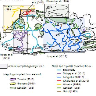
Fig. Captions. Fig. 1. Generalized geologic map of eastern Nepal after Akiba et al. (1973), Carosi et al. (1993b),
, Carosi et al. (1993b),") 41 Fig. Captions Fig. 1. Generalized geologic map of eastern Nepal after Akiba et al. (1973), Carosi et al. (1993b), Lombardo et al. (1993), and our field interpretations. The upper left inset shows the
41 Fig. Captions Fig. 1. Generalized geologic map of eastern Nepal after Akiba et al. (1973), Carosi et al. (1993b), Lombardo et al. (1993), and our field interpretations. The upper left inset shows the
B) color B) Sediment must be compacted and cemented before it can change to sedimentary rock. D) igneous, metamorphic, and sedimentary rocks
 color B) Sediment must be compacted and cemented before it can change to sedimentary rock. D) igneous, metamorphic, and sedimentary rocks") 1. Which characteristic of nonsedimentary rocks would provide the least evidence about the environment in which the rocks were formed? A) structure B) color C) crystal size D) mineral composition 2. Which
1. Which characteristic of nonsedimentary rocks would provide the least evidence about the environment in which the rocks were formed? A) structure B) color C) crystal size D) mineral composition 2. Which
6. Relative and Absolute Dating
 6. Relative and Absolute Dating Adapted by Sean W. Lacey & Joyce M. McBeth (2018) University of Saskatchewan from Deline B, Harris R, & Tefend K. (2015) "Laboratory Manual for Introductory Geology". First
"When Gregor Samsa woke up one morning from unsettling dreams, he found himself changed into a monstrous bug. Metamorphosis, by Franz Kafka
 Metamorphosis "When Gregor Samsa woke up one morning from unsettling dreams, he found himself changed into a monstrous bug. Metamorphosis, by Franz Kafka Metamorphism The transformation of rock by temperature
Thermobarometry of the Leo Pargil Dome, NW India: Insights into Exhumation of Mid-Crustal Rocks in the Himalaya
 Pursuit - The Journal of Undergraduate Research at the University of Tennessee Volume 2 Issue 1 Spring 2011 Article 4 March 2011 Thermobarometry of the Leo Pargil Dome, NW India: Insights into Exhumation
GTK GeoKernel and Data Management. Material from Niina Ahtonen, Esa Kauniskangas and Tero Rönkkö
 GTK GeoKernel and Data Management Esa Kauniskangas 31.5.2010 Material from Niina Ahtonen, Esa Kauniskangas and Tero Rönkkö 1 GTK s operational areas Northern Finland Office Rovaniemi Western Finland Office
The Rock Cycle & Plate Tectonics
 The Rock Cycle & Plate Tectonics I. The Rock Cycle 1. Rocks are the most common material on Earth. 2. They are made up of one or more minerals. A. The rock cycle explains how Earth processes change a rock
GEO 103. OBJECTIVES Familiarity with general facts, principles and concepts of Earth and Earth Processes
 GEO 3 Familiarity with general facts, principles and concepts of Earth and Earth Processes 1 2 5 6 7 8 Identify Earth materials and use simple geological tools Become familiar with geologic data, as displayed
Earth Science 11: Geologic Time Unit
 Earth Science 11: Geologic Time Unit Text: Chapters 8 Lab: Exercise 6 Name Earth Science 11: Geologic Time Page 1 Geology 12: Geologic Time 8.1: The Geologic Time Scale Today, we know that Earth is approximately
2) Question: Very briefly describe the differences between these two types of metamorphism:
 Question: Very briefly describe the differences between these two types of metamorphism:") Name: Grade: GEOL 101 - Physical Geology Laboratory METAMORPHIC ROCKS PRELAB & LAB WORKSHEETS PRELAB SECTION To be completed before labs starts: I. Introduction & Purpose: The purpose of this laboratory
Name: Grade: GEOL 101 - Physical Geology Laboratory METAMORPHIC ROCKS PRELAB & LAB WORKSHEETS PRELAB SECTION To be completed before labs starts: I. Introduction & Purpose: The purpose of this laboratory
8 th Grade Science Tutoring. Earth Space, Ms. Winkle
 8 th Grade Science Tutoring Earth Space, Ms. Winkle List of Topics PART ONE Atoms, molecules, elements, mixtures, compounds Density Physical vs chemical changes Weathering, Erosion, Deposition (include
Satulinmäki Au Prospect Structural Mapping
 M19/2024/2003/1/10 Juhani Ojala Satulinmäki Au Prospect Structural Mapping V. Juhani Ojala Geological Survey of Finland 1 Table of Contents Introduction...2 Local geology...2 Structures...2 Discussion...2
INSPIRE and egovernment policies: a common governance for a wider public sector information infrastructure
 INSPIRE and egovernment policies: a common governance for a wider public sector information infrastructure Gabriele Ciasullo Leonardo Donnaloia Antonio Rotundo 2 EU needs and actions Reference document
Do Now (2 minutes) 3/19. K What I know about Metamorphic Rocks. W What I want to find out about Metamorphic Rocks
 3/19. K What I know about Metamorphic Rocks. W What I want to find out about Metamorphic Rocks") Do Now (2 minutes) K What I know about Metamorphic Rocks 3/19 W What I want to find out about Metamorphic Rocks 1. 2. 3. 1. 2. 3. What are metamorphic rocks and how do we classify them? Metamorphic Rocks
Do Now (2 minutes) K What I know about Metamorphic Rocks 3/19 W What I want to find out about Metamorphic Rocks 1. 2. 3. 1. 2. 3. What are metamorphic rocks and how do we classify them? Metamorphic Rocks
Earth Science Lesson Plan Quarter 3, Week 7, Day 1
 Earth Science Lesson Plan Quarter 3, Week 7, Day 1 Outcomes for Today Standard Focus: PREPARE 1. Background knowledge necessary for today s reading. Continental ice sheets increase the weight of the Earth
CHAPTER VI CONCLUSIONS
 CHAPTER VI CONCLUSIONS In this Chapter, salient observations made in understanding the various tectonothermal events, including U-Pb in-situ monazite geochronology of Sargur schists and granulites exposed
Introduction. Introduction. Chapter 7. Important Points: Metamorphism is driven by Earth s s internal heat
 Chapter 7 Metamorphism and Metamorphic Rocks Introduction Metamorphism - The transformation of rocks, usually beneath Earth's surface, as the result of heat, pressure, and/or fluid activity, produces metamorphic
Engineering Geology. Metamorphic Rocks. Hussien Al - deeky
 Metamorphic Rocks Hussien Al - deeky 1 Definition Metamorphic rock is the result of the transformation of an existing rock type, the protolith (parent rock), in a process called metamorphism, which means
Earth Science - Lab #11 Geologic Time
 Earth Science - Lab #11 Geologic Time Page # Below are standard geologic symbols for the 3 main categories of rocks. Although these symbols are not universal, they are generally accepted by most geologists
New geologic mapping + and associated economic potential on northern Hall Peninsula, Baffin Island, Nunavut
 New geologic mapping + and associated economic potential on northern Hall Peninsula, Baffin Island, Nunavut Holly Steenkamp, M.Sc. Regional Mapping Geoscientist David Mate, M.Sc. Chief Geologist November
Metamorphic Rocks and the Rock Cycle
 Petrology Session 3 Metamorphic Rocks and the Rock Cycle Presented by Dr. I Wayan Warmada warmada@gmail.com What are Rocks? Most rocks are an aggregate of one or more minerals, and a few rocks are composed
POSSIBILITY FOR APPLICATION OF GIS TECHNOLOGIES IN RTB BOR GROUP
 MINING AND METALLURGY INSTITUTE BOR UDK: 622 ISSN: 2334-8836 (Štampano izdanje) ISSN: 2406-1395 (Online) UDK: 681.33:622.343(045)=111 doi:10.5937/mmeb1603021v Nenad Vušović *, Marko Vuković **, Igor Svrkota
Metamorphism / Metamorphic Rocks
 Metamorphism / Metamorphic Rocks Metamorphism: occurs when rocks are subjected to heat, pressure, and/or other environmental conditions - The rock remains a solid during this time period - Why Should You
Quiz Three (9:30-9:35 AM)
") Quiz Three (9:30-9:35 AM) UNIVERSITY OF SOUTH ALABAMA GY 112: Earth History Lecture 7 & 8: Dating Instructor: Dr. Douglas W. Haywick Last Time 1. William Smith and Water 2. Stratigraphic Principles 3.
Quiz Three (9:30-9:35 AM) UNIVERSITY OF SOUTH ALABAMA GY 112: Earth History Lecture 7 & 8: Dating Instructor: Dr. Douglas W. Haywick Last Time 1. William Smith and Water 2. Stratigraphic Principles 3.
Geologic Time: Hutton s Outcrop at Siccar Point. How do we determine age (relative & absolute) What is the age of the earth? How do we know?
 What is the age of the earth? How do we know?") Geologic Time: How do we determine age (relative & absolute) What is the age of the earth? How do we know? What is the age of the Earth? A. 4.44 million years B. 1 million years C. 4.55 billion years D.
Geologic Time: How do we determine age (relative & absolute) What is the age of the earth? How do we know? What is the age of the Earth? A. 4.44 million years B. 1 million years C. 4.55 billion years D.
The Geology of Pacific Northwest Rocks & Minerals Activity 1: Geologic Time
 Name: Age: I. Introduction There are two types of geologic time, relative and absolute. In the case of relative time geologic events are arranged in their order of occurrence. No attempt is made to determine
MEMO. TO: Dennis Lapoint CC: FROM: Eriaan Wirosono DATE: April, 20 th 2014 SUBJECT: Exploration activity report March-April 2014_EW
 TO: Dennis Lapoint CC: FROM: Eriaan Wirosono DATE: April, 20 th 2014 SUBJECT: Exploration activity report March-April 2014_EW MEMO 1. Highlights and Productivity Overview pan sampling on target Areas 1
Metamorphism: summary in haiku form
 Metamorphism & Metamorphic Rocks Earth, Chapter 8 Metamorphism: summary in haiku form Shape-shifters in crust. Just add heat and/or pressure. Keep it solid please! What Is Metamorphism? Metamorphism means
Welcome to GEO 101 Introduction to Geology
 Welcome to GEO 101 Introduction to Geology so what is Geology? not just rocks! Geology is... study of Earth and planetary bodies processes responsible for formation processes that modify all areas of geology
Quiz Seven (2:00 to 2:02 PM)
") Quiz Seven (2:00 to 2:02 PM) UNIVERSITY OF SOUTH ALABAMA GY 111: Physical Geology Lecture 22: Agents of Metamorphism Instructor: Dr. Douglas W. Haywick Last Time Rock Deformation A) Confining pressure
Quiz Seven (2:00 to 2:02 PM) UNIVERSITY OF SOUTH ALABAMA GY 111: Physical Geology Lecture 22: Agents of Metamorphism Instructor: Dr. Douglas W. Haywick Last Time Rock Deformation A) Confining pressure
GLY 155 Introduction to Physical Geology, W. Altermann. Press & Siever, compressive forces. Compressive forces cause folding and faulting.
 Press & Siever, 1995 compressive forces Compressive forces cause folding and faulting. faults 1 Uplift is followed by erosion, which creates new horizontal surface. lava flows Volcanic eruptions cover
3D Urban Information Models in making a smart city the i-scope project case study
 UDC: 007:528.9]:004; 007:912]:004; 004.92 DOI: 10.14438/gn.2014.17 Typology: 1.04 Professional Article 3D Urban Information Models in making a smart city the i-scope project case study Dragutin PROTIĆ
Planned Geology Courses (revised ) courses in red are broadcast (IVC) or online, courses in black are face-to-face only
 courses in red are broadcast (IVC) or online, courses in black are face-to-face only") Planned Geology Courses (revised 08-23-2018) courses in red are broadcast (IVC) or online, courses in black are face-to-face only Geology Courses - Fall 2018 GEO 1110 - Physical Geology (3) Lachmar GEO
Planned Geology Courses (revised 08-23-2018) courses in red are broadcast (IVC) or online, courses in black are face-to-face only Geology Courses - Fall 2018 GEO 1110 - Physical Geology (3) Lachmar GEO
GIS at UCAR. The evolution of NCAR s GIS Initiative. Olga Wilhelmi ESIG-NCAR Unidata Workshop 24 June, 2003
 GIS at UCAR The evolution of NCAR s GIS Initiative Olga Wilhelmi ESIG-NCAR Unidata Workshop 24 June, 2003 Why GIS? z z z z More questions about various climatological, meteorological, hydrological and
GY 112 Lecture Notes Rock Review
 GY 112 Lecture Notes D. Haywick (2006) 1 GY 112 Lecture Notes Rock Review Lecture Goals: A) Recap of rock types B) Recap of the rock cycle C) Sedimentary rocks: their role in earth history Textbook reference:
Pilot Applications deployment
 Pilot Applications deployment ISPRA- Geological Survey of Italy Carlo Cipolloni Workshop INSPIRE Conference 2014 Aalborg 17 th June Scenarios >> Pilots: INSPIRE Data Themes In 10 pilots, 9 Scenarios, 3
METAMORPHIC ROCKS CHAPTER 8
 Lecture 6 October 18, 20, 23 October 19, 24 METAMORPHIC ROCKS CHAPTER 8 This is only an outline of the lecture. You will need to go to class to fill in the outline, although much of the relevant information
Metamorphism: Alteration of Rocks by Temperature and Pressure
 CHAPTER 6 Metamorphism: Alteration of Rocks by Temperature and Pressure Chapter Summary Metamorphism is the alteration in the solid state of preexisting rocks, including older metamorphic rocks. Increases
CHAPTER V ECONOMIC EFFECTIVENESS OF THE GEOLOGICAL INVESTIGATION Based on Contract No. 01/2014/VLSK of Prospecting for gold at the scale of 1:25,000
 CHAPTER V ECONOMIC EFFECTIVENESS OF THE GEOLOGICAL INVESTIGATION Based on Contract No. 0/204/VLSK of Prospecting for gold at the scale of :25,000 over the 99. km 2 area in North, Northeast of Vang Tat,
Name: KEY. Examine all possible answers; some may not satisfy the question criteria and should be left blank. mica crystals big enough to see
 GE 50 Exam #3, FS07 Name: KEY_ Examine all possible answers; some may not satisfy the question criteria and should be left blank. 1. Match the metamorphic rock with its foliated texture. [10 pts] slate
Metamorphic Energy Flow. Categories of Metamorphism. Inherited Protolith Character. Inherited Fabric. Chemical Composition
 Metamorphic Energy Flow Categories of Metamorphism Best, Chapter 10 Metamorphic processes are endothermic They absorb heat and mechanical energy Absorption of heat in orogenic belts Causes growth of mineral
Tecnologie GIS nella scelta dei dati di input per modellazioni numeriche 3D dello stato di fratturazione.
 GIT - Geology and Information Technology Group Sezione di Geologia Informatica della Società Geologica Italiana SECONDA RIUNIONE NAZIONALE 4-6 giugno 2007 Bevagna (PG) Tecnologie GIS nella scelta dei dati
Instructor s Manual Chapter 3
 CHAPTER 3 Resource Integration Guide Chapter Outline Chapter Summary Lecture Suggestions Key Terms Web Links Virtual Field Trip Suggested Responses Chapter Outline 3.1 and the Rock Cycle 3.1a The Rock
Deformation: Modification of Rocks by Folding and Fracturing
 CHAPTER 7 Deformation: Modification of Rocks by Folding and Fracturing Chapter Summary A geologic map is a scientific model of rock formations that are exposed on the Earth s surface showing outcrops,
Geosciences Data Digitize and Materialize, Standardization Based on Logical Inter- Domain Relationships GeoDMS
 Geosciences Data Digitize and Materialize, Standardization Based on Logical Inter- Domain Relationships GeoDMS Somayeh Veiseh Iran, Corresponding author: Geological Survey of Iran, Azadi Sq, Meraj St,